孙斌栋 , 但波
, 但波
SUN Bindong, DAN Bo
通讯作者:
收稿日期: 2014-11-4
修回日期: 2015-05-19
网络出版日期: 2015-10-20
版权声明: 2015 《地理学报》编辑部 本文是开放获取期刊文献,在以下情况下可以自由使用:学术研究、学术交流、科研教学等,但不允许用于商业目的.
基金资助:
作者简介:
作者简介:孙斌栋(1970-), 男, 河北阜平人, 博士, 教授, 博士生导师, 中国地理学会会员(S110006693M), 主要研究方向为城市地理、城市规划和区域经济。E-mail: bdsun@re.ecnu.edu.cn
展开
摘要
伴随中国快速城市化与机动化进程,私人汽车拥有量不断增长,由此引起的交通拥堵和环境问题已成为制约中国城市可持续发展的难题。基于上海市区的居民通勤问卷调查数据,采用多项Logit模型检验了街道尺度城市建成环境对于居民通勤方式选择的影响,结果表明,在控制了其他因素后,提高居住地的人口密度、土地利用混合度与十字路口比重,可以减少小汽车通勤方式的选择,而就业地建成环境对居民通勤方式选择影响相对较弱;建成环境对通勤方式选择的影响会因个体的社会经济异质性而不同。这些结论为通过优化土地利用规划来优化居民通勤结构的城市交通和城市规划政策提供了启示。
关键词:
Abstract
With the rapid urbanization and motorization in China, the increasing car ownership promotes the dependence on automobile commuting, and hinders sustainable development and leads to serious traffic congestion and environment pollution as well. Based on the questionnaire survey from the residents in the central city of Shanghai, a multinomial logit model was applied to explore the impact of built environment on residents' commuting mode. It is concluded that the urban built environment has a significant effect on the choice of motorized commuting. Specifically, after limiting other factors, improving population density, mixed land use and the proportion of crossroads in residential areas may help refrain the choice of automobile commuting, while urban built environment of employment areas has less impact on residential choice commuting mode. Besides, the built environment has different impacts on commuting mode choice due to heterogeneity of individual socio-economic characteristics. The policy implication of the research results is that commuting mode could be optimized by improving land use planning and transit environment designing.
Keywords:
1978年以来,随着中国经济的快速发展和城市化进程的快速推进,大城市规模急剧膨胀,居民通勤距离与通勤时间不断延长,导致居民机动化出行需求不断增加,大城市居民对小汽车出行日渐依赖。以上海市为例,2000-2012年间,上海市私人汽车拥有量由5.04万辆增加到141.16万辆①,2004-2009年上海小汽车出行比重提高了5个百分点,达到20.9%②,由此引起的交通拥堵和环境问题已成为中国大城市可持续发展的难题。对香港、东京等城市的研究发现,城市的持续繁荣未必会引起小汽车使用率的提升,而技术发明与出行行为的转变则是实现城市绿色交通的关键[1]。城市地理和城市规划学者试图通过优化城市空间组织,创造一个以绿色交通为导向的城市建成环境,减少城市居民小汽车使用。然而,城市居民的出行行为受众多因素影响,国内有关城市建成环境与居民通勤方式选择关系的研究还比较缺乏,难以为城市规划与交通决策提供科学依据。为此,本文首先综述国内外相关研究成果,进一步介绍研究地区背景、数据概况与研究方法,接着呈现多项Logit模型回归结果,最后探讨城市建成环境与居民通勤方式选择之间的联系,以期对大城市绿色交通的发展提供实证支持。
20世纪60年代以来,随着发达国家小汽车进入家庭,由此而引起的城市交通拥堵及环境污染问题越来越受到关注,城市建成环境与居民出行行为的关系得到了广泛而深入的研究。尽管城市建成环境因素复杂多样,但主要可以归纳为3个方面:密度(Density)、混合度(Diversity)、设计(Design)[2]。多数研究认为,密度与通勤行为存在密切联系。随着密度的增加,居住地更加邻近就业地,通勤距离减短,居民更多的采用公共交通及非机动通勤方式,减少小汽车的使用[3-5]。如Moilanen对挪威的研究发现,高密度发展能更好使待业者在当地找到匹配自己的工作,郊区的高密度发展有利于减少长距离通勤需求[6]。在通勤方式选择上,采取公共交通及步行出行方式的比重与通勤起讫点人口密度/就业密度之间存在显著的正向关系[7]。此外,高密度区域公共交通的组织更加有效,城市通达性得到改善,公共交通及非机动通勤比例增加,从而也减少了小汽车的使用率[8-11]。过度高密度发展也会引起交通中心化造成更加严重的交通拥堵[12],对于小汽车来讲出行时间增加,从而也在一定程度上减少了小汽车使用率[3, 13-14]。也有学者研究认为,对于通勤而言,居民是否选择小汽车出行与密度关系微弱甚至没有[2],而居民的出行态度与生活方式影响最大[15]。
城市建成环境中,在一定区域范围内高度混合的土地利用方式也可能诱导居民采用绿色通勤方式[2-3, 7]。一方面,混合的土地利用方式可以增加居民就近工作的机会,减少小汽车通勤需求[16-17];另一方面,混合土地利用有可能使得居民其他出行需求在通勤路线上或者附近得到满足,减少小汽车出行需求[9]。但也有学者研究认为,对通勤而言,混合土地利用对于出行方式选择影响不显著[10, 15, 18]。
城市设计中,连续畅通的人行道,方格网状的道路布局,宜人的非机动出行环境,传统邻里设计,可以为居民提供一个安全、舒适、便捷的绿色出行环境,诱导居民采用非机动及公共交通通勤方式[2-3, 18-19]。例如,提高居住地交叉路口比例,居民选择步行/自行车上班可能性也增加,而就业地断头路比例的增加则会诱导居民采取小汽车通勤方式[10];道路连通度的增加有利于诱导居民选择非机动通勤方式[20];在控制了其他因素后,社区环境评分越高,居民选择步行去工作比例也随之增加[21]。
国内关于建成环境与通勤行为的研究中,何舟等对城市通勤时耗的空间结构影响因素做了详细的综述[22],实证研究则主要针对北京、上海等城市。其中,对北京的通勤方式研究发现,居住地人口密度与居民机动通勤模式存在负向关系,但道路网密度与工作地就业密度的提高则会增加居民机动通勤的可能性[5]。对深圳研究发现,距离城市中心越远,居民选择小汽车通勤方式可能性越高[23]。但对上海的研究却发现,社区建成环境变量对于居民通勤方式选择影响不显著[24]。也有研究发现小尺度街区高密度路网、混合土地利用等变量并没有鼓励居民选择非机动通勤方式,反而是鼓励了小汽车的选择,小汽车通勤灵活方便尤其是当支路普遍用于停车时降低的小汽车使用成本与职住偏离被认为是导致此结果的原因[25]。
除了建成环境因素之外,个体的通勤行为还受到通勤距离/时间与社会经济等因素的影响。大量实证研究证明,通勤距离/时间越长,居民选择机动化通勤方式概率越高[5, 24]。收入、职业、家庭规模、学历、小汽车拥有量、孩子数、性别及年龄等社会经济因素对居民选择小汽车通勤方式的影响也得到很多实证支持[2, 5, 9, 11, 24-25]。
综上所述,居民的通勤方式选择主要受到城市建成环境、通勤时间/距离和个人及家庭社会经济因素的影响。发达国家城市建成环境与居民出行行为关系的研究比较成熟,但国外学者对发展中国家城市建成环境关注较少,而国内学者对建成环境因素影响通勤方式选择的研究鲜有涉猎。中国城市的建成环境对通勤方式选择的影响与发达国家具有共同的规律还是有所不同,这需要立足国内实证做进一步的研究。
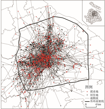
为了研究上海居民通勤行为与城市建成环境之间的关联,2009年3至5月周末在上海外环高架线以内地区(图1)进行居民通勤问卷调查。在问卷开始之前首先选取了长宁区的仙霞小区进行试点调查,在试点调查过程中发现,由于反感其日常生活遭到打扰,居民参与问卷调查的积极性很低,且愿意接受调研的居民明显是低收入群体。这样造成大规模问卷调查的难度较高,而且样本选择明显有偏,因此在每个行政区选择4个小区作为抽样地点的原计划被放弃。考虑到公园是开放空间,容纳了不同经济与社会地位的人群;上海各类型的绿地公园较多,分布相对均匀,使得样本具有一定的代表性;居民在宽松的环境中,意愿参与问卷的可能性较大,因此调研计划变更为,根据各行政区人口比重,在每个区内选取空间分布均衡的2~3个公园作为抽样地点,每个公园随机调查50名居民,展开问卷调查工作。本调查共收回相对完整的问卷1200份,根据研究目的,剔除数据存在缺失的问卷,整理出有效问卷857份,有效率71.42%。
图1 研究区域位置、样本分布及通勤流
Fig. 1 The location of the study area and the distribution of samples and commuter flow
为了更加细致的了解到调查样本的地理分布问题,通过百度地图,进一步获取居民居住地与就业地的位置信息,并将其可视化,从图1被访者居住与就业位置的分布可以看出,样本绝大多数位于外环线内部,且多位于浦西地区,仅有少部分位于外环线以外。分别从居住地与就业地分布来看,居住地多在浦西地区,分布也相对均匀,就业地则在中心区域更加集中,通勤流也在市中心区域高度密集,向心性明显。以上现象符合上海就业高度集中在中心区域、居住相对分散的实际情况。因此从地理分布来看,本样本对于研究上海外环线以内区域具有一定的代表性。
根据可得性资料与以上问卷得到了被访者通勤起讫点街道建成环境、通勤时间/距离及社会经济属性3个方面的描述性统计分析,并与可得的上海中心城区相关信息进行比照进一步考察样本代表性。
(1)城市建成环境特征。建成环境因素主要以街道为尺度,从通勤起讫点四个维度展开:① 土地利用混合度。采用就业用地(工矿仓储用地、商服用地与公共建筑用地)与居住用地(住宅用地)比值测度就业用地和居住用地的混合度。② 道路设计。采用交通运输用地比(交通运输用地面积/街道总面积)反映道路网密度,并用高架路与一二三四等级道路的道路网密度作稳健性检验;采用十字路口比(十字路口数占街道总路口数的比值)测度道路通达性。③ 密度。包括居住地人口密度(街道常住人口/街道总面积)与工作地就业密度(街道就业岗位/街道总面积)。④ 区位特征。就业岗位密度最高街道的几何中心被定义为就业主中心,各街道几何中心与就业主中心的直线距离反映各空间单元的区位。
表1 建成环境与通勤变量描述性统计
Tab. 1 The descriptive statistics of built environment and commuting variables
| 变量名 | 样本数量 | 均值 | 标准差 | 最小值 | 最大值 |
|---|---|---|---|---|---|
| 居住地 | |||||
| 人口密度(万人/km2) | 857 | 2.62 | 1.25 | 0.26 | 5.88 |
| 土地利用混合度 | 857 | 1.08 | 0.81 | 0.25 | 6.83 |
| 交通运输用地比 | 857 | 0.19 | 0.07 | 0.07 | 0.61 |
| 十字路口比 | 857 | 0.44 | 0.12 | 0.13 | 0.94 |
| 距主中心距离(km) | 857 | 8.19 | 4.54 | 0 | 26.92 |
| 就业地 | |||||
| 就业密度(万人/km2) | 857 | 2.23 | 1.77 | 0.03 | 8.14 |
| 土地利用混合度 | 857 | 1.14 | 1.12 | 0.25 | 6.83 |
| 交通运输用地比 | 857 | 0.20 | 0.08 | 0.04 | 0.61 |
| 十字路口比 | 857 | 0.45 | 0.11 | 0.08 | 0.94 |
| 距主中心距离(km) | 857 | 7.21 | 5.66 | 0 | 39.35 |
| 通勤时间(min) | 857 | 39.17 | 23.84 | 1 | 150 |
| 通勤距离(km) | 857 | 8.88 | 8.53 | 0.10 | 89.60 |
(2)通勤特征。包括被访者的单程通勤时间与通勤距离(表1)和通勤方式(表2)。本调查的居民平均通勤时间为39.17分钟,略低于上海市第四次综合交通调查报告中的中心城居民上下班平均通勤时间(43.2分钟)。其中,通勤方式分为四类:① 步行占14.35%;② 自行车与助动车占14.59%;③ 小汽车(含出租车与摩托车)占10.50%;④ 公共交通(含单位班车、地铁与公交)占60.56%,为主要的通勤方式。此外,不同通勤方式在不同距离内存在分化,步行、自行车/助动车主要适用于中短距离通勤,长距离出行主要采用机动化的通勤方式,公共交通的平均通勤距离与时耗最长。
表2 不同通勤方式所占比例及平均通勤距离/时间
Tab. 2 The proportion of commuting modes and the average commuting distance/duration
| 通勤方式选择 | 样本数量 | 比重(%) | 平均通勤距离(km) | 平均通勤时间(min) |
|---|---|---|---|---|
| 小汽车 | 90 | 10.50 | 8.99 | 32.62 |
| 步行 | 123 | 14.35 | 1.17 | 14.86 |
| 自行/助动车 | 125 | 14.59 | 4.62 | 25.63 |
| 公共交通 | 519 | 60.56 | 11.72 | 49.33 |
| 共计 | 857 | 100.00 |
(3)居民社会经济特征(表3)。包括被访者的性别、年龄、收入、受教育程度、家庭规模、家庭未成年人数、家庭就业人数和居住性质。被访者男性较多(63.94%),略高于与上海第六次人口普查就业人口数据中的相应比重(57.89%);被访者受教育水平以大学专/本科为主,74.33%的被访者月收入在6000元以下,年龄在21~30岁与31~40岁的居民比例分别为54.38%和33.02%;自有房居民与租房居民数量差异不大,分别为51.34%与42.12%,还有6.54%居民居住在单位分房;被访者家庭户平均人数为2.59人,与六普数据接近(2.53);被访者家庭就业平均人数以1~2人为主,占全部样本的86%;有2个或以上未成年人的家庭仅占2%,绝大多数家庭没有未成年人或有1个未成人,这是计划生育政策的结果,后面计量检验中将使用家庭有无未成年人虚拟变量来代替未成年人数变量。以上社会经济属性,没有与普查数据或其他数据渠道进行对比的是因为缺乏可对比数据来源。
表3 研究区居民社会经济特征
Tab. 3 Social and economic characteristics of residents in the study area
| 样本数量 | 比重(%) | 样本数量 | 比重(%) | ||||
|---|---|---|---|---|---|---|---|
| 家庭就业人数(个) | 1 | 298 | 34.77 | 居住性质 | 自有房屋 | 440 | 51.34 |
| 2 | 437 | 50.99 | 单位分房 | 56 | 6.54 | ||
| 3及以上 | 122 | 14.24 | 租房 | 361 | 42.12 | ||
| 家庭未成年人数(个) | 0 | 532 | 62.08 | 年龄(岁) | 20及以下 | 17 | 1.98 |
| 1 | 305 | 35.59 | 21~30 | 466 | 54.38 | ||
| 2及以上 | 20 | 2.33 | 31~40 | 283 | 33.02 | ||
| 月收入(元) | 0~4000 | 450 | 52.51 | 41~50 | 64 | 7.47 | |
| 4001~6000 | 187 | 21.82 | 51及以上 | 27 | 3.15 | ||
| 6001~8000 | 95 | 11.09 | 性别 | 男 | 548 | 63.94 | |
| 8001~10000 | 53 | 6.18 | 女 | 309 | 36.06 | ||
| 10001及以上 | 72 | 8.40 | 文化程度 | 初中及以下 | 36 | 4.20 | |
| 家庭规模(个) | 1 | 206 | 24.04 | 高中/职中 | 178 | 20.77 | |
| 2 | 150 | 17.50 | 大学专科/本科 | 557 | 64.99 | ||
| 3及以上 | 500 | 58.34 | 硕士及以上 | 86 | 10.04 | ||
总结以上可知,问卷调查的抽样过程已经尽可能的考虑到了样本的代表性和随机性,而且从样本的地理分布、平均通勤时间来看,较具有代表性。尽管样本代表性还存在不足,但考虑到本文主要目的是研究样本通勤与建成环境之间的关系,而不是反映样本通勤本身,故在一定程度上是可接受的。
表4 多项逻辑模型回归结果(以小汽车通勤方式为参照)
Tab. 4 The results of multinomial logit model ('commuting by car' as reference)
| 变量 | 模型1:解释变量未纳入通勤距离 | 模型2:解释变量纳入通勤距离 | |||||
|---|---|---|---|---|---|---|---|
| 步行 | 自行/助动车 | 公共交通 | 步行 | 自行/助动车 | 公共交通 | ||
| 建成环境特征 居住地 | |||||||
| 人口密度 | 0.4572* | 0.4621** | 0.3897** | 0.7166*** | 0.5033** | 0.3300* | |
| 土地利用混合度 | 0.4831 | 0.6011** | 0.5526** | 0.6463* | 0.6162** | 0.5015** | |
| 十字路口比 | 3.6437** | 3.0694* | 2.8221** | 3.5076* | 3.1742* | 3.1398** | |
| 交通运输用地比 | -0.3090 | 1.5252 | -1.7619 | 1.2909 | 2.0077 | -1.3349 | |
| 距主中心距离 | -0.0733 | 0.0176 | -0.0148 | 0.0325 | 0.0481 | -0.0511 | |
| 就业地 | |||||||
| 就业密度 | -0.1766 | 0.0006 | 0.2106** | -0.0374 | 0.0586 | 0.1505 | |
| 土地利用混合度 | -0.1520 | 0.2715** | -0.0420 | 0.0079 | 0.2536* | -0.0223 | |
| 十字路口比 | -0.7570 | -1.3369 | -1.7141 | 0.2991 | -2.0901 | -1.2933 | |
| 交通运输用地比 | -0.8767 | -1.8941 | 0.4958 | -0.4079 | -2.0355 | 0.8172 | |
| 距主中心距离 | -0.0505 | -0.0400 | 0.0333 | -0.0397 | --0.0462 | 0.0017 | |
| 个体社会经济特征 | |||||||
| 住房性质 | |||||||
| 单位分房(是=1) | -0.1996 | -1.0505 | -1.8464*** | -0.8518 | -1.0334 | -1.9700*** | |
| 自有房屋(是=1) | -2.4706*** | -1.1923*** | -0.7561* | -2.5363*** | -0.8434* | -0.9580** | |
| 性别(男=1) | -0.9866** | -0.1329 | -0.4948 | -1.3091*** | -0.1068 | -0.7492** | |
| 年龄(岁) | |||||||
| 31~40(否=0) | -1.5436*** | -0.7424* | -1.0081*** | -1.6292*** | -0.7910* | -0.9419** | |
| 41~50(否=0) | 1.1518 | 0.7265 | 0.7726 | 2.0302** | 0.8467 | 0.9929 | |
| 51及以上(否=0) | -1.0115 | 0.3030 | -1.2921 | -0.1994 | 0.0934 | -1.0561 | |
| 月收入(元) | |||||||
| 4001~6000(否=0) | -0.9824** | -1.5316*** | -0.9756** | -0.5899 | -1.4952*** | -1.0663*** | |
| 6001~8000(否=0) | -0.7321 | -1.1503** | -0.4742 | 0.2486 | -0.9386* | -0.4925 | |
| 8001~10000(否=0) | 0.1012 | -2.4054*** | -1.0384** | 0.7223 | -2.3141*** | -1.3281** | |
| 10001及以上(否=0) | -2.2980*** | -3.2988*** | -2.0403*** | -1.1082 | -2.9749*** | -2.1424*** | |
| 家庭特征 | |||||||
| 家庭规模 | -0.2607 | -0.4422** | -0.1173 | -0.0414 | -0.4350* | -0.1554 | |
| 家庭就业人数 | 0.3185 | 0.5601* | 0.2573 | 0.0882 | 0.4694 | 0.2505 | |
| 是否有未成年人(是=1) | -0.8385* | 0.1022 | -1.3111*** | -1.2809** | -0.0758 | -1.2285*** | |
| 通勤距离 | -1.1223*** | -0.1556*** | 0.0937*** | ||||
| 截距 | 2.8410 | 0.4590 | 2.4125 | 2.7502 | 1.2014 | 2.2839 | |
| N | 857 | 857 | |||||
| Pseudo R2 | 0.2061 | 0.4039 | |||||
| Log likelihood | . | -748.2758 | . | . | -561.8536 | . | |
| Chi2 | 388.5232 | 761.3677 | |||||
为了研究建成环境与居民通勤方式选择的联系,考虑到本文将通勤方式为归并为4个离散的类别,意在探讨城市建成环境对于居民不同通勤方式的影响差异,多项Logit模型(Multinomial Logit Model)可以满足研究需求,且对数据没有正态性要求,所以本文构建了多项Logit模型方程,如下:
式中:Logit(P1/P2)为选择任意两种通勤方式概率比值的自然对数;X1为街道建成环境特征,包括密度、土地利用混合度、十字路口比、交通运输用地比与距主中心距离;X2为居民社会经济属性特征,包括性别、年龄、学历、月收入、家庭规模、家庭就业人数、家庭有无未成年人及居住性质;X3为单程通勤距离;
将小汽车通勤方式作为步行、自行/助动车和公共交通三种通勤方式的参照,在公式(1)的基础上构建了如下方程用于具体回归分析:
表4报告了根据公式(2)~(4)的多项Logit回归分析结果。从模型拟合优度看,模型卡方(Chi-Square)统计量分别为388.5232与761.3677,在5%水平上显著,表明模型的拟合程度较好。通勤距离与交通方式选择之间具有双向因果关系,为了缓解内生性,也计算了不包含通勤距离的模型回归结果,但并不影响建成环境变量的作用方向和显著度。模型1与模型2结果基本一致,因而表4给出的回归结果具有稳健性。
回归结果显示,在控制了个体社会经济特征及通勤距离后,居民的通勤方式选择与居住地建成环境有显著关联,而与就业地关系相对较弱。在模型1中,就业地变量有两项显著,一是就业地就业密度与公共交通通勤方式显著正相关,这与实际相符。在上海,就业密度高的地区,公共交通服务也十分便利。同时,此结果也与已有研究[5, 10, 27, 28]结论相似,如Zhang对于波士顿的研究和Zhao对于北京的研究都发现就业地就业密度的增加会显著提高居民采用公共交通通勤的可能性[5, 10]。Chen等与Paaswell对纽约大都市区的研究与Chatman对美国的研究也发现由于停车与拥堵问题,就业地就业密度的增加会减少小汽车通勤的可能性[4, 26]。二是就业地土地利用混合度(就业居住用地比)的增加显著提高居民采用自行/助动车的可能性,可能的原因在于,自行车尤其是助动车机动灵活,速度快,花费少,受拥堵影响小,因而在中国特大城市中在很多情况下比小汽车具有优势。
居住地人口密度对居民通勤方式选择有显著的影响,人口密度越高,居民选择小汽车通勤方式的可能性减小。在模型1中,街道1 km2每增加10000人,居民选择步行相对于小汽车通勤方式的发生比率将增加[Exp(0.4572)-1]×100% = 58%,选择自行/助动车相对于小汽车通勤方式的发生比率将增加59%,选择公共交通相对于小汽车通勤方式的发生比率将增加48%。一方面,在上海居住在人口密度较高街道的居民,通勤距离较短,增加了非机动通勤可达性。另一方面,在高密度区域,地铁与公交服务设施完善,公共交通可达性高。此外,高密度区域的停车困难,以及在上下班时段的交通拥堵问题,也是造成小汽车通勤可能性降低的原因。这一结果与大多数已有文献的结论一致,城市高密度发展可以降低居民小汽车出行需求,鼓励公共交通与非机动通勤。如Cervero对于美国的研究,Zhao对于北京的研究都发现人口密度的提高会减少居民开车上班的可能性,增加公共交通与非机动通勤方式的使用[5, 9]。在发达国家公共交通通勤的份额往往十分低,而在上海,公交与地铁服务系统发达完善,已经成为居民主要的通勤方式。
表5 建成环境变量与社会经济因素交互项回归结果
Tab. 5 The regression results of interaction between built environment and socioeconomic variables
| 变量 | 模型1:解释变量未纳入通勤距离 | ||
|---|---|---|---|
| 步行 | 自行/助动车 | 公共交通 | |
| 居住地土地利用混合度×性别 | 1.4095** | 0.6501 | 0.6040 |
| (0.6356) | (0.4519) | (0.4135) | |
| 居住地人口密度×年龄dummy(31-40) | -0.7013* | -0.6705* | -0.4644 |
| (0.3913) | (0.3457) | (0.3137) | |
| 居住地十字路口比×月收入dummy(10001及以上) | 10.5619 | 19.1280** | 6.0700 |
| (8.5664) | (7.5962) | (4.3486) | |
土地利用混合度参数表明,相对于小汽车通勤方式而言,居住在土地利用相对混合街道的居民,更有可能选择非机动或公共交通通勤方式。以模型1结果为例,土地利用混合度每增加一个单位,选择自行/助动车通勤方式的发生比率是选择小汽车通勤方式的Exp(0.6011)= 1.82倍,选择公共交通通勤方式发生比率是选择小汽车通勤方式的Exp(0.5526)= 1.74倍。这一结果与已有研究结论一致[2, 9, 27],如Van Acker等对比利时弗兰德斯根特的研究发现,土地利用混合度越高,小汽车通勤使用越少[27],也与预期相符,即对上海而言,在居住地街道增加就业用地,有助于居民就近就业,缩短通勤距离,减少居民对小汽车通勤的依赖。但是也应该看到,由于数据的缺乏,本文并没有考虑到就业岗位与居民就业需求的匹配问题。
城市设计方面,居住地街道十字路口比重提高会增加步行、自行/助动车及公共交通通勤方式的概率,此结果与Zhang与Badland等的研究结论相似[10, 20],其发现居住地十字路口比例的增加将会增加非机动通勤的可能性。一方面,较高的十字路口比重意味着较高的交通通达性,会促进步行与自行/助动车的使用。另一方面,道路通达性的提高,同时也使得公共交通的组织更加有效;反之,较低的十字路口比重会降低道路网通达性水平,增加居民通勤对小汽车的依赖。表4还显示,在控制其他变量后,交通运输用地比不显著,换成高架路与一二三四等级道路的道路网密度,依然对通勤方式没有显著影响,后一结果本文中没有报告。此结论表明,在城市道路网设计中,应该更加重视路网的形式与布局设计。此外,居住地与就业主中心的距离对居民通勤方式选择没有显著影响,而已有研究发现,距离主中心越远,选择小汽车[9-10]与公共交通[5]可能性将会增加。为此尝试在模型1中去掉居住地人口密度与土地利用混合度,发现随着居住地距中心距离的增加将会显著提高小汽车通勤相对步行与公共交通的可能性。这表明距主中心距离的变量效用已经被密度与土地利用混合特征所细化,因为邻近市中心地区的密度和就业居住用地比也越高,是共线原因导致了模型1中距就业主中心距离的不显著。
以上结果只是显示了在其他变量既定的情况下建成环境对通勤方式选择的平均影响,其实,在不同社会经济因素属性下,建成环境对通勤方式选择的作用也会存在差异。为了检验这一异质性的存在,本文构造了表4中统计显著的建成环境变量与社会经济变量的交互项,并作为解释变量分别单独带入表4回归模型1中,发现了3个统计显著、较为稳健并具有一定逻辑解释力的交互项结果(表5)。首先,居住地土地利用混合度和性别的交互项与步行方式显著正相关,这表明,增加居住地土地利用混合度尽管对全部样本的步行影响不显著,但对于男性是有显著作用的。其次,居住地人口密度与31~40岁年龄段虚拟变量的交互项,与步行和自行/助动车显著负相关,表明对于31~40岁年龄段的通勤者来说,增加居住地人口密度所提高的步行和自行车/助动车通勤可能性,显著低于其他年龄段。另外,居住地十字路口比与10001元及以上的月收入组的交互项,与自行车/助动车通勤显著正相关,意味着提高居住地十字路口比所增加的自行/助动车通勤可能性,对于10001元及以上的月收入组作用更明显。这些结果表明,建成环境对通勤方式选择的影响不仅存在独立效应,而且其作用还会因个体的社会经济异质性而不同。
居民通勤方式选择与内生性变量单程通勤距离有显著的相关性。如在模型2中,通勤距离每增加1 km,居民选择小汽车通勤方式的发生比率是选择步行的1/Exp(-1.1223)= 3.07倍,是选择自行/助动车的1.17倍。造成这种现象的原因是,通勤距离的增加使得步行与自行/助动车的可达性下降,而步行通勤方式对距离更加敏感。在公共交通参照小汽车模型中,通勤距离每增加1 km,居民选择公共交通通勤方式的发生比率是选择小汽车的1.10倍。此结果与发达国家通勤距离越长越趋向于使用小汽车通勤方式的普遍认识[9]存在显著差异,本文分析主要有以下几个方面的原因:首先,上海城市密度高,人均道路面积较少,在上下班时段,交通拥堵造成小汽车通勤困难,而上海相对完善的公交尤其是轨道系统可以较好地保证居民准点上下班,因而远距离通勤时小汽车并不比公共交通具有时间优势;其次,中国城市居民收入相对较低,对出行成本比较敏感,公共交通金钱花费明显低于小汽车;最后,在轨道交通上,居民可以自由安排此段时间(例如学习、娱乐等)。这些结果也与Pan等对上海的研究、Zhao对北京的研究结果是一致的,即通勤时间越长,机动化交通工具比非机动方式更具优势,但选择公共交通的可能性高于小汽车[1, 5]。
表4也展示了个体的社会经济特征对于通勤方式选择的影响。首先,模型的结果验证了收入对于居民通勤方式选择的影响,在控制其他变量后,随着收入水平的提高,居民对小汽车通勤成本的承担能力增强,因而居民小汽车通勤可能性也相应增加。居住性质方面,自有房屋居民比租房居民更愿意采用小汽车通勤,可能的原因是租房居民住房选择具有很大的灵活性,可以更加靠近上班地点居住。年龄方面,与31岁以下居民相比,31~40岁居民选择小汽车通勤可能性较高,可能的解释是,31~40岁居民具有了一定的工作经验与物质基础,因而有条件选择小汽车通勤方式,而且这个年龄段的人受近10~20年中国汽车进入家庭的社会观念影响较大。性别方面差异也较明显,男性比女性选择小汽车通勤的可能性更高,尤其在只有一辆小汽车的家庭中,男性对小汽车的使用占据了优势。家庭方面,有未成年人的家庭,选择小汽车通勤概率越大,这与上海实际是符合的,因为有未成年人的家庭,考虑到孩子上下学、就医甚至业余补课的需要,往往会加快家庭购车的节奏,小汽车通勤的可能性也就更高。
针对发达国家城市建成环境与居民通勤方式选择的关联研究较为充分,而对于国内这一领域的研究还比较缺乏。在中国快速城市化和机动化的背景下,本文基于上海问卷调查数据,运用多项Logit模型检验了城市建成环境对于居民通勤方式选择的影响。结果发现,在控制了其他因素后,街道尺度居住地建成环境对于居民通勤方式选择存在显著影响。具体而言,提高居住地的人口密度、土地利用混合度与十字路口比例,可以促进职住邻近,减少通勤距离,提高道路的连接性,提升交通服务使公共交通组织更加有效,最终减少居民选择小汽车通勤可能性,诱导居民采用步行、自行/助动车与公共交通模式通勤;增加就业地就业密度与土地利用混合度,可以诱导公共交通与自行/助动车通勤模式;而且,建成环境对通勤方式选择的影响会因个体的社会经济异质性而不同。这些结论与西方发达国家城市的研究结论基本一致,为基于优化城市空间组织来引导居民出行行为的规划理念提供了有力的实证支持。关于通勤距离对通勤方式的影响,随着上海居民通勤距离变长,小汽车比非机动通勤方式更具优势,但与公共交通相比却处于劣势,后一点与西方发达国家的研究结论不同,这与上海乃至中国特大城市特有的城市交通环境和公共交通基础有关。
本文对于优化小汽车使用政策具有以下两个启示。一方面,在街道土地利用规划方面,应该坚持高密度、紧凑的发展模式,同时在居住地的周围布局商业购物及娱乐消费用地,形成混合功能特征,吸引居民就近就业、购物与消费;在路网规划方面,应尽可能多地采用十字交叉口的方格网式道路布局,增加道路通达水平,完善公共交通系统,并辅以步行为导向的街道规划。另一方面,鉴于建成环境对于不同社会经济家庭背景下居民通勤行为的影响存在异质性,且有一定规律,因此,只有考虑到不同社会群体通勤行为的差异,才能有针对性的制定城市交通管理政策,对缓解城市交通拥堵发挥真正作用。
本文是基于上海市外环线以内及邻近区域问卷调查数据的计量分析结果,尽管得到有一些有意义的发现,但本文的研究还是探索性的,尤其是由于数据和信息的缺乏,在机制解释方面较弱,对于居民通勤方式的主动选择与被动选择没有深入分析。此外,本文的问卷样本采集于公园当中,其代表性需要进一步提高。
The authors have declared that no competing interests exist.
| [1] |
Impacts of urban forms on travel behavior: Case studies in Shanghai .城市形态对居民出行的影响: 上海实例研究 . |
| [2] |
Travel demand and the 3Ds: Density, diversity, and design . |
| [3] |
Built environments and mode choice: Toward a normative framework . |
| [4] |
How density and mixed uses at the workplace affect personal commercial travel and commute mode choice . |
| [5] |
The impact of the built environment on individual workers' commuting behavior in Beijing .https://doi.org/10.1080/15568318.2012.692173 Magsci [本文引用: 8] 摘要
The increasing emission of transport-related pollutants has become a key issue in relation to climate change mitigation and the improvement of air quality in China's cities. This article aims to examine the effects of changes in the built environment on transportation by examining the case of Beijing. Looking at household survey data, the analysis found that individual workers' commuting behavior (concerning travel destination, mode choice and travel time) is significantly related to some aspects of the built environment when socioeconomic and demographic characteristics are taken into account. There are obvious differences in the effects of the built environment on commuting across income groups, occupations and industries.
|
| [6] |
Matching and settlement patterns: The case of Norway . |
| [7] |
Impacts of mixed use and density on utilization of three modes of travel: Single-occupant vehicle, transit, and walking . |
| [8] |
Effect of employment site characteristics on commute mode choice . |
| [9] |
Mixed land-uses and commuting: Evidence from the American Housing Survey .https://doi.org/10.1016/0965-8564(95)00033-X URL [本文引用: 4] 摘要
Past research suggests that mixed land-uses encourage non-auto commuting; however, the evidence remains sketchy. This paper explores this question by investigating how the presence of retail activities in neighborhoods influences the commuting choices of residents using data from the 1985 American Housing Survey. Having grocery stores and other consumer services within 300 feet of one's residence is found to encourage commuting by mass transit, walking and bicycling, controlling for such factors as residential densities and vehicle ownership levels. When retail shops are beyond 300 feet yet within 1 mile of residences, however, they tend to encourage auto-commuting, ostensibly because of the ability to efficiently link work and shop trips by car. The presence of nearby commercial land-uses is also associated with relatively low vehicle ownership rates and short commuting distances among residents of a mixed-use neighborhood. Overall, residential densities exerted a stronger influence on commuting mode choices than levels of land-use mixture, except for walking and bicycle commutes. For non-motorized commuting, the presence or absence of neighborhood shops is a better predictor of mode choice than residential densities.
|
| [10] |
The role of land use in travel mode choice: Evidence from Boston and Hong Kong . |
| [11] |
The influence of socioeconomic characteristics, land use and travel time considerations on mode choice for medium-and longer-distance trips . |
| [12] |
The paradox of intensification .https://doi.org/10.1016/j.tranpol.2010.05.007 Magsci [本文引用: 1] 摘要
<h2 class="secHeading" id="section_abstract">Abstract</h2><p id="">Urban intensification as part of a smart growth strategy can facilitate low-energy transport modes and reduce overall car use, with benefits to the global environment, but evidence suggests the effect will be less than proportional. Hence, in locations where intensification occurs, greater concentrations of traffic tend to occur, and this worsens local environmental conditions. This phenomenon is defined below as the ‘paradox of intensification’. The consequent challenges for planners and policymakers, which arise, are considered. The analysis suggests that a compromise involving limited intensification would merely redistribute the balance between the two sets of problems: global and local. It is concluded that urban intensification should be accompanied by more radical measures to constrain traffic generation within intensified areas.</p><h2 class="secHeading" id="section_gabs">Graphical Abstract</h2><h4 id="secGabs_N3055af80N25b01390">Research Highlights</h4><p>?Urban intensification tends to reduce overall car use. ?The relationship is inelastic, particularly at the level of the individual development. ?This means urban intensification worsens local concentrations of traffic. ?Unless it is accompanied by more radical traffic restraint measures.</p>
|
| [13] |
Density and the journey to work . |
| [14] |
The impact of metropolitan structure on commute behavior in the Netherlands: a multilevel approach . |
| [15] |
A micro-analysis of land use and travel in five neighborhoods in the San Francisco Bay Area . |
| [16] |
Travel behavior as function of accessibility, land use mixing, and land use balance: Evidence from San Francisco Bay Area . |
| [17] |
Which reduces vehicle travel more: Jobs-housing balance or retail-housing mixing? |
| [18] |
Travel choices in pedestrian versus automobile oriented neighborhoods . |
| [19] |
What affects commute mode choice: Neighborhood physical structure or preferences toward neighborhoods? |
| [20] |
Travel behavior and objectively measured urban design variables: Associations for adults traveling to work . |
| [21] |
Cragg S E et al. Exploring the effect of the environment on physical activity: A study examining walking to work . |
| [22] |
|
| [23] |
Impact of land use development on travel mode choice: A case study in Shenzhen .https://doi.org/10.3969/j.issn.1672-5328.2011.05.009 URL [本文引用: 1] 摘要
为缓解日益严重的城市交通问题、优化居民出行方式,有必要研究城市土地利用与交通系统的协调 问题。以深圳市为例,应用多元Logit模型(MNL模型),纳入城市土地利用变量与出行者的家庭、社会、经济等变量,分析其对居民工作与非工作出行方式 的影响。研究结果表明,出行起点的城市区位是影响居民出行方式的重要因素之一。相对于组团中心和非中心区的出行者,城市中心和城市副中心的出行者选择公共 交通的可能性更高。同时,还从城市规划和设计角度,对优化居民出行方式提出了政策性建议。
城市土地利用特征对居民出行方式的影响: 以深圳市为例 .https://doi.org/10.3969/j.issn.1672-5328.2011.05.009 URL [本文引用: 1] 摘要
为缓解日益严重的城市交通问题、优化居民出行方式,有必要研究城市土地利用与交通系统的协调 问题。以深圳市为例,应用多元Logit模型(MNL模型),纳入城市土地利用变量与出行者的家庭、社会、经济等变量,分析其对居民工作与非工作出行方式 的影响。研究结果表明,出行起点的城市区位是影响居民出行方式的重要因素之一。相对于组团中心和非中心区的出行者,城市中心和城市副中心的出行者选择公共 交通的可能性更高。同时,还从城市规划和设计角度,对优化居民出行方式提出了政策性建议。
|
| [24] |
Influence of urban form on travel behavior in four neighborhoods of Shanghai .
Since the 1980s, cities in China have expanded tremendously due to fast-paced economic growth and urbanization. Much of the new urban development has departed significantly from the traditional high density, pedestrian and bicycle oriented urban form that used to characterize Chinese cities. Has the change in urban form generated significant effects on people’s travel behavior? This is a question of great practical importance for urban planners in China as they strive toward sustainable development. The question is also of considerable scholarly interest, because it can potentially lead to improved understanding of the relationship between the built environment and travel behavior. This paper presents an effort to answer the question through a study of travel behavior in four neighborhoods of Shanghai, which have contrasting urban form characteristics. A travel survey was conducted in 2001, which generated 1,817 valid observations for our empirical analysis. In testing the relationship between travel behavior and the built environment, two statistical models are estimated. One is an ordinary least squares regression of trip distance, and the other is a multiple logistic regression of mode choice. Results from the modeling exercise indicate clearly that in the traditional neighborhood with relatively high densities and small street blocks, trip distance is much shorter and the chance for choosing walk or bike as travel mode is much greater. These findings suggest that recent transformation of the built environment in Chinese cities has made it less conducive to the “greening” of urban transportation.
|
| [25] |
Urban land-use characteristics and commuters' travel pattern: A case study of west Hangzhou .大城市街区建成环境特征与居民通勤方式研究: 以杭州城西为例 . |
| [26] |
Role of the built environment on mode choice decisions: Additional evidence on the impact of density .https://doi.org/10.1007/s11116-007-9153-5 Magsci [本文引用: 1] 摘要
<a name="Abs1"></a>Density is a key component in the recent surge of mixed-use neighborhood developments. Empirical research has shown an inconsistent picture on the impact of density. In particular, it is unclear whether it is the density or the variables that go long with density that affect people’s travel behavior. Many existing studies on density neglect confounding factors, for example, residential self-selection, generalized travel cost, accessibility, and access to transit stations. In addition, most still use a single trip as their observation unit, even though trip chaining is well recognized. The goal of this paper is to assess the role of density in affecting mode choice decisions in home-based work tours, while controlling for confounding factors. Using the dataset collected in the New York Metropolitan Region, we estimated a simultaneous two-equation system comprising two mutually interacting dependent variables: car ownership and the propensity to use auto. The results confirm the role of density after controlling for the confounding factors; in particular, employment density at work exerts more influence than residential density at home. The study also demonstrates the importance of using tour as the analysis unit in mode choice decisions. The study advances the field by analyzing the role of the built environment on home-based work tours. New knowledge is obtained in the relative contribution of density vs. a set of correlated factors, including generalized travel cost, accessibility, and access to transit stations.
|
| [27] |
Commuting trips within tours: how is commuting related to land use? https://doi.org/10.1007/s11116-010-9309-6 URL [本文引用: 1] 摘要
Studies that model the effects of land use on commuting generally use a trip-based approach or a more aggregated individual-based approach: i.e. commuting is conceptualized in terms of modal choice, distance and time per single trip, or in terms of daily commuting distance or time. However, people try to schedule activities in a daily pattern and, thus, consider tours instead of trips. Data from the 2000 to 2001 Travel Behaviour Survey in Ghent (Belgium) illustrate that car use and commuting times significantly differ between commuting trips within work-only tours and more complex tours. Therefore, this paper considers trip-related decisions simultaneously with tour-related decisions. A multiple group structural equation model (SEM) confirmed that the relationship between land use and commuting differs between work-only tours and more complex tours. Trips should be considered within tours in order to correctly understand the effect of land use scenarios such as densifying on commuting. Moreover, the use of multiple group SEM enabled us to address the issue of the complex nature of commuting. Due to interactions between various explanatory variables, land use patterns do not always have the presumed effect on commuting. Land use policy can successfully influence commuting, but only if it simultaneously accounts for the effects on car availability, car use, commuting distance and commuting time.
|

/
| 〈 |
|
〉 |