

1 引言
公共服务是人民群众的基本生活需求,是提升生活质量、促进高质量发展与共同富裕的重要内容。中国经济快速发展伴随着日益严峻的社会不公平问题,一个重要的方面就体现在公共服务的不公平,公平已成为新时代公共政策与空间规划的焦点议题。中国共产党“十九大”报告中作出了“我国社会主要矛盾已经转化为人民日益增长的美好生活需要和不平衡不充分的发展之间的矛盾”的重大判断。因此,提升公共服务配置的充分性与平衡性,是当前阶段的一项紧迫任务。自“十一五”时期以来,基本公共服务均等化已上升为国家重要战略,最新编制的《“十四五”公共服务规划》针对这一目标的实现进行了总体部署。
医疗设施等公共设施的优化配置是地理学经典命题[1-2]。医疗设施空间分布会影响需求者使用行为及效果[1],是从空间上落实基本公共服务均等化的关键。地理学者在公共设施空间分布特征和布局评价两方面取得了显著进展[3]。在空间分布特征方面,已有研究从不同尺度分析了公共服务资源的分布特征[4⇓-6],并探讨其动态演变趋势[7]与形成机制[8-9]。在布局评价方面,很多研究利用基于GIS的空间可达性方法,评价设施布局的合理性与公平性[10⇓⇓-13]。然而,这些研究只能给出改善布局的定性建议,无法定量确定优化方案。为科学确定设施最优布局,国内外地理学、运筹学等学科的研究者提出了一系列优化配置(Location-allocation)模型[14⇓-16]。经典优化配置模型通常关注效率导向的优化目标,如P-中位模型目标为到最近设施的平均出行距离最近[16-17],最大覆盖模型目标为覆盖需求人口最多[18],而位置集合模型目标为覆盖全部人口所需设施数量最少[19]。虽然公平目标的政策价值突出,但由于建模和求解等难度,空间公平导向的优化配置模型一直是研究难点[20⇓-22]。
最大可达性均等(Maximal Accessibility Equality, MAE)模型[20]是空间公平导向优化配置模型的最新进展。该模型将公共服务的空间公平界定为在顾及供给与需求人口空间匹配关系的基础上,各地区居民获取公共服务可达性的差异程度,并通过优化模型使可达性的地区间差异最小化。由于空间公平问题求解涉及到非线性规划问题,该研究将优化问题转换为二次规划问题进而求解[20]。考虑到已有研究认为可达性的空间差异或群体差异能够较好反映公共资源的“机会公平”,通常以可达性的地区差异为基础测度空间公平[11-12,23 -24],因此MAE模型能较好地衡量和优化公共服务的空间公平性。MAE模型的理论基础体现在3个方面:① 地理学及相关学科对于空间公平理论内涵及测度方法的研究;② 作为MAE模型基础的可达性概念,是地理学中对于公共服务供给和需求空间相互作用的综合表述;③ 空间优化研究关注公共资源空间配置如何达到最优的整体福利水平。
自2013年提出以来,MAE模型迅速得到了大量应用和发展。Tao等[25]将MAE模型应用于养老设施优化配置研究,并引入粒子群优化(Particle Swarm Optimization, PSO)算法来提高求解效率,并后续探讨了基于预测人口的优化研究[26]。Wang等[27]探讨了设施区位的优化问题。Li等[28]基于MAE模型提出了一个两阶段的优化方式,其中第一阶段优化设施区位,第二阶段优化设施资源规模,发现区位优化提升空间公平的效果更显著。Luo等[29]将传统效率导向的优化配置模型与MAE模型相结合,提出了“提升空间可达性的两阶段优化(2SO4SAI)”方法,通过两阶段的优化兼顾效率与公平目标。戴特奇等[30]将MAE模型应用于学区配置优化问题,针对“多校划片”随机入学方式中的学位分配进行公平导向优化。Dai等[31]进一步引入概率方法来衡量就学机会。Liao等[32]结合就学机会空间公平性和缩短就学距离两方面,构建了多目标优化模型。Li等[33]则着重关注空间效率和空间公平之间的权衡关系,并将两阶段优化模型与区位选择和资源优化同步优化模型进行比较。空间公平的测度指标是MAE模型的关键。在最初构建的MAE模型[20]中,采用可达性的方差来测度空间不公平程度,优势是能够转换为二次规划问题进行求解。随后的应用[25,28⇓ -30]中都沿用了这一空间公平测度指标。然而,正如王法辉等[21]指出,方差指标对异常值较为敏感,亟待研究不同空间公平测度指标的差异。事实上,空间差异与空间公平的测度指标研究非常丰富[34⇓-36]。这些测度指标在优化配置模型中表现如何,亟待通过基于真实案例的比较研究来回答。
基于此,本文旨在系统梳理常见的空间公平测度指标,构建并比较基于这些指标的MAE模型。一方面从理论上解析各个测度指标的空间公平内涵;另一方面基于深圳市医疗设施案例,比较各个指标在优化配置研究中的表现。医疗设施是设施优化配置模型的典型应用场景[1,20,22],因此以医疗设施为例具有代表性。本文在方法上的创新在于,针对MAE模型中仅采用方差指标作为目标函数的不足,引入另外9个常用空间公平测度指标作为改进MAE模型的目标函数,并通过比较发现基于变异系数、平均绝对偏差和帕尔玛比值3个指标的改进MAE模型在理论内涵和优化效果方面的综合表现最好。本文进一步推进了空间公平导向设施优化配置模型的发展,对于地理学关于空间公平理论与分析方法的讨论也提供了有益探索。在实践意义方面,为基本公共服务均等化战略的空间落实、公共服务设施布局规划提供了更加科学且可操作的分析方法。
2 数据与方法
2.1 研究区与数据来源
图1
图1
深圳市行政区划及人口和现状医疗设施分布
Fig. 1
Distribution of administrative divisions, population and healthcare facilities in Shenzhen
研究数据主要包括3类:① 人口数据来源于深圳各区第七次人口普查数据公报中的街道尺度常住人口数据,共74个街道单元。② 医疗设施数据,包括地址及医生数属性,来源于深圳市卫生健康委员会,收集时间为2021年7月,并采用百度地图地址编码应用编程接口(Application Programming Interface, API)转换为标准地理坐标。研究中仅考虑已定级的71家综合医院,总医生数量为19924人。③ 出行时间数据,采用百度地图路线规划API测算。为反映城市居民出行方式的多样性,分别采用驾车规划和公交规划API测算了两种交通方式的出行时间。由于街道单元面积较大,容易增大分析误差,本文在社区尺度测算出行时间。社区列表及人口数据来源于深圳市2010年第六次人口普查,共包括771个社区。首先,以社区服务中心为出发点,医院为目的点,测算每个社区到每家医院的驾车、公交方式最短出行时间;然后,根据社区人口规模进行加权平均,得到各街道到医院的出行时间;最后,根据各区机动化出行中驾车和公交方式的分担率[39],得到多交通方式的平均出行时间。
2.2 研究方法
2.2.1 空间可达性评价方法
空间可达性是指各地区居民获取公共服务等资源的潜在机会和难易程度[1],测度方法非常多样,如最近距离法、供需比例法、累积机会法、重力模型法、两步移动搜寻法等[10,13]。可达性受到多方面因素的影响,包括土地利用因素(即设施分布)、交通因素、时间因素和个人因素[40]。其中,设施分布及其与需求分布的关系和交通方式是空间可达性研究中的关键因素[1]。两步移动搜寻法(Two-step Floating Catchment Area, 2SFCA)是应用最广泛的空间可达性评价方法之一,具有考虑因素较为综合、计算过程和结果易于理解等优势[1]。针对传统2SFCA方法忽略搜寻区内可达性差异的不足,很多研究提出改进,加入了不同形式的距离衰减函数[13,41 -42]。本文中采用高斯型2SFCA,即加入高斯型距离衰减函数的改进2SFCA方法,该方法具有距离衰减效应强度适中、仅有一个参数的优势[13,41]。
高斯2SFCA方法原理包括两个步骤:首先,根据需求点规模及距离衰减函数值,将每个设施的资源分配给搜寻区内的需求点;其次,将每个需求点从其搜寻区范围内可达设施能够竞争得到的资源进行求和,即可得到需求点的可达性值,含义为平均每个需求者可获得的潜在服务资源量。该方法的计算公式为:
式中:Ai是需求点i的可达性值;Sj是设施j的服务规模,本文中为医生数;Pk是需求点k的需求量,即常住总人口;dij和dkj分别是需求点和设施之间的交通成本,由综合驾车和公交模式的出行时间表示;D0为设施的搜寻区半径;f为高斯型距离衰减函数,可表示为:
2.2.2 最大可达性均等(MAE)模型
MAE模型的基本原理是,在满足设施资源投入量和可达性计算规则等约束条件下,寻求最优的设施布局方案,以使得目标函数所表征的空间公平指标最大化,即可达性差异程度最小化。在MAE模型中,采用方差来测度可达性的空间差异或空间公平程度,方差越小则空间公平程度越高。MAE模型的目标函数是使可达性方差最小化,可表达为:
式中:Ai是可达性,由高斯型2SFCA计算;Pi是需求规模;n是需求点数量;待求解的决策变量为可达性计算中的供给变量Sj。MAE模型由公式(1)~(3)以及对决策变量Sj的约束条件构成。在应用中,Sj的设定有3种方式:① 采取给定的设施候选点(即可配置设施的区位)及给定的设施总规模,对Sj的数值组合进行优化,称为设施资源分配优化问题[20,25];② 考虑在现状设施基础上新增一定数量的设施,对新增设施的区位(即Sj取值为0或1)进行优化,称为区位优化[27];③ 将上述两种方式相结合,先进行区位优化,再进行设施资源优化[28]。然而,后两种问题的求解难度大,且对于新增设施区位和数量的确定需要较多论证。考虑到本文的主要目的是模型比较研究,且深圳市目前综合医院的分布较为分散,因此仅考虑设施资源分配优化问题。MAE模型的求解采取粒子群优化算法,该算法的有效性和效率已在研究[25-26,45]中得到验证。需指出的是,本文根据各个模型中采用的空间公平目标函数形式,对粒子群优化算法的适应函数进行了修正。
2.2.3 空间公平及其测度指标
表1 主要空间公平测度指标
Tab. 1
| 指标 | 公式 | 指标 | 公式 |
|---|---|---|---|
| 方差(VAR) | 标准差(SD) | ||
| 变异系数(CV) | 平均绝对偏差(MAD) | ||
| 基尼系数(Gini) | 最大偏差(MaxD) | ||
| 值域(Range) | 最小值最大化(MaxMin) | ||
| 帕尔玛比值(Palma) | 泰尔指数(Theil) |
注:
方差和标准差是用于测度数据差异程度的基础指标。本文对方差和标准差指标进行了两处调整:① 用可达性的人口加权平均值表示平均值,如前所述,人口加权平均可达性恒等于总供给与需求之比;② 对每个单元的可达性与加权平均可达性偏差的平方项进行人口加权,以考虑不同单元的人口规模差异,反映基于“人”而不是空间单元的空间公平。类似地,在变异系数和平均绝对偏差指标中,也对各单元的可达性差异值进行人口加权平均,以更好地反映基于人的空间公平,在后文中不再赘述。
变异系数由标准差除以平均值所得,可以消除数据量纲的影响。对于MAE模型应用而言,可达性数据是给定的,因此变异系数和标准差的作用应是等价的。
上述3个指标中,都包含可达性与均值偏差的平方项,对于可达性高值和低值较为敏感[21]。相比之下,平均绝对偏差指标利用偏差的绝对值来衡量差异,具体是以人口为权重对各单元可达性与加权平均可达性的绝对偏差进行加权平均。
上述指标都考虑了所有空间单元的可达性情况,而在最大偏差、最小值最大化、值域和帕尔玛比值4个指标中,只考虑可达性的部分特殊值。最大偏差指标衡量各空间单元可达性与平均值的最大绝对偏差,可能来源于最大值或最小值。值域指标衡量可达性的取值范围,即最大值与最小值之间的间隔。最小值最大化指标则不关注高于平均值的部分,只关注可达性的最小值,在优化中旨在使可达性最小值的最大化。帕尔玛比值反映的是收入最高的10%人口所占收入份额与最差40%人口所占份额的比值,在近些年的收入差距研究中逐渐替代基尼系数[51]。
泰尔指数是一种常用的基于信息论的不确定性测度指标,通常也用于测度数据的差异程度。它的一个重要优势是能够将总体差异分解至多个空间尺度,但在本文中暂不需要使用这一性质。在10个指标中,只有最小值最大化指标对空间公平的作用方向为正,即指标值越大意味着空间公平程度越高,其他指标均相反。因此,在优化模型的目标函数中,对最小值最大化指标进行最大化,对其他指标则进行最小化。
2.2.4 不同模型优化结果的比较方法
从两个方面对不同模型的优化结果进行比较,以综合评价各模型的效果。一是利用最大值、最小值、中位数和标准差等统计指标,对不同模型优化后设施规模和可达性的分布进行比较。此外,还绘制可达性的分布曲线和洛伦兹曲线,可以全面考察可达性的分布情况。二是对不同模型的优化结果进行交叉比较。具体思路为,每个模型的优化可达性是在该模型的空间公平测度指标最优化目标下,所得到的最优可达性。在交叉比较中,将每个模型的优化可达性都采用10个空间公平测度指标分别进行评价,从而反映各个模型结果在不同空间公平测度指标下的综合表现,选出总体优化效果最好的指标和优化模型。
3 结果分析
3.1 现状可达性的空间公平评价
本文采用高斯2SFCA测算了深圳市现状医疗服务可达性,作为后续分析的基础,分布如图2所示。深圳现状医疗服务可达性分布并不均衡,总体上呈现中心城区优于外围地区、东部地区优于西部地区的特点。市域西北部是医疗可达性最薄弱的地区,包括光明区及宝安区和龙华区的北部。这说明目前深圳医疗资源配置与人口之间存在较明显的空间不匹配问题。
图2
图2
2020年深圳市现状医疗可达性分布
Fig. 2
Distribution of actual healthcare accessibility in Shenzhen in 2020
表2中展示了深圳市基于不同指标测度的现状医疗服务可达性空间公平结果。从基尼系数来看,通常认为基尼系数大于0.4时意味着明显的收入差距,因此深圳现状医疗服务可达性呈现一定的空间差异,但差异程度较为适中。标准差衡量的是平均意义上每个评价单元可达性与加权平均可达性的差异程度,是加权平均可达性(1.139×10⁻³人)的0.319倍。变异系数正好是该比值,可以较为直观地理解其数值。平均绝对偏差与标准差的含义类似,但处理方式不同,相较于标准差和方差对偏差的敏感性较为适中,从指标取值看平均绝对偏差确实比标准差更小。最大偏差、值域和最小值最大化3个指标的原理类似,3个指标都只考虑可达性的极值,没有考虑所有单元的可达性水平。在收入差距领域,现实的帕尔玛比值通常大于1,因此帕尔玛比值意味着深圳现状医疗可达性的差异程度相对适中。
表2 深圳现状医疗服务可达性的空间公平测度
Tab. 2
| 指标 | 方差(VAR) | 标准差(SD) | 变异系数(CV) | 平均绝对偏差(MAD) | 基尼系数(Gini) |
|---|---|---|---|---|---|
| 结果 | 1.323×10⁻⁷ | 3.638×10⁻⁴ | 0.319 | 2.874×10⁻⁴ | 0.325 |
| 指标 | 最大偏差(MaxD) | 值域(Range) | 最小值最大化(MaxMin) | 帕尔玛比值(Palma) | 泰尔指数(Theil) |
| 结果 | 7.758×10⁻⁴ | 1.4×10⁻³ | 4.942×10⁻⁴ | 0.522 | 0.078 |
3.2 不同模型优化结果比较
图3中利用箱型图对不同模型优化设施规模和可达性的分布情况进行比较。箱形图的优势是能够排除异常值,图中方框上下边界分别反映指标的上、下四分位数,方框中红色横线表示中位数,方框外的黑色横线表示非异常数值的上限和下限,红色“+”表示异常数值。如图3a所示,在VAR、SD、CV和Theil模型中,优化设施规模的中位数非常接近下四分位数,说明优化结果中有很多小规模(接近模型设定的规模下限20个医生)的设施,优化结果与实际中的医疗设施规模分布不符合。其他6个模型的优化设施规模分布则较为合理。如图3b所示,在MAD、Gini和Palma模型中,优化可达性分布较为紧凑,其次是SD、CV和Theil模型,前2个模型的分布非常类似。综合这两方面,MAD、Gini和Palma 3个模型的优化结果表现较好。
图3
图3
不同模型的优化设施规模和可达性统计比较
Fig. 3
Comparisons of optimal facility sizes and accessibility of various models
图4展示了10个模型得到的优化可达性之间的相关系数,以比较模型优化结果之间的相关性。VAR、SD和CV 3个模型的优化可达性高度相关,因为3个模型的空间公平测度指标在数学上可以直接转换。Palma和Theil模型的优化可达性与上述3个模型结果也呈高度相关。此外,MAD与Gini模型、MaxD与Range模型之间相关性较高,而MaxMin模型优化结果与其他模型的相关性相对较低。图4最后一列统计了每个模型优化结果与其他模型相关系数的平均值,可以反映每个模型与其他模型的总体相关情况。总体而言,VAR、SD、CV、Palma和Theil 5个模型的优化可达性结果非常类似,MAD和Gini模型为第二梯队,MaxD和Range模型为第三梯队,MaxMin模型与其他模型结果相关性最低。
图4
图4
不同模型的优化可达性的相关系数
Fig. 4
Correlations between optimal accessibility of various models
本文绘制了每个模型优化可达性的洛伦兹曲线,但由于优化可达性的差异程度都较小,洛伦兹曲线形状较接近,难以直观比较。因此,本文绘制了各个模型优化可达性的帕尔玛比值分布图,包括前10%和后40%空间单元的可达性占比、两者之间的比值(即帕尔玛比值)(图5)。帕尔玛比值的优势在于可以揭示较高的不公平程度是来自于高值区还是低值区。可见,Palma模型优化结果中,后40%单元的可达性占比并非最高,前10%单元可达性占比也没有明显低于其他模型,但由于在两个方面表现都较好,因此帕尔玛比值最小。相比之下,MAD和Gini模型中,虽然后40%单元的可达性占比较高,但前10%单元可达性占比也较高,因此帕尔玛比值较大。而MaxD和Range模型则相反,较大的帕尔玛比值主要是由于后40%单元的可达性占比较低。MaxMin模型则在高值区和低值区的表现都较差,因此帕尔玛比值明显大于其他模型,说明该模型虽然尽可能地提高了可达性的最低值,但对于后40%低值区的可达性提升并不明显,同时也加剧了高值区的优势,总体对空间公平的优化效果较差。
图5
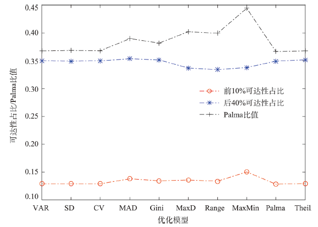
图5
不同模型优化可达性的帕尔玛比值比较
Fig. 5
Comparisons of Palma ratios for optimal accessibility of various models
进一步对不同模型的优化结果进行交叉评估,即将每个模型的优化可达性,用10个空间公平测度指标进行评估(图6)。由于测度指标的方向不同,MaxMin指标值越大意味着空间公平测度高,而其他指标相反。此外,不同指标的取值范围也存在差异。因此,图6中对所有指标评价值进行了标准化,标准化后取值范围为0~1,值越大表示空间公平程度越高。可见,不同模型交叉评估结果与图4中的优化可达性相关系数情况较为类似,VAR、SD、CV、Palma和Theil 5个模型的优化效果关联性较强,MAD与Gini模型之间关联较强,MaxD与Range模型关联较强,MaxMin模型与其他模型的关联最弱。从每个模型优化结果在10个测度指标下的平均表现来看,Theil、VAR、SD和CV模型最好,Palma模型其次,Gini、Range和MaxD模型处于第三梯队,MAD模型处于第四梯队,MaxMin模型最差。
图6
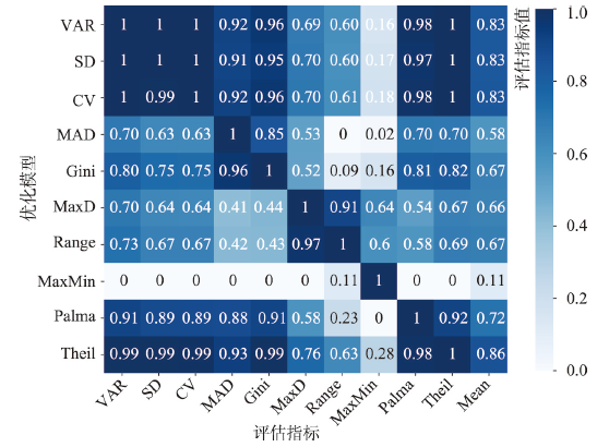
图6
不同模型优化结果与空间公平指标的交叉评估
Fig. 6
Performance of each model in terms of various spatial equity measures
综合上述比较,CV、MAD和Palma 3个模型的总体表现较好。VAR和SD模型与CV在数学原理上等价,评价结果也接近,但CV指标便于进行解读,因此建议这3个模型中优先使用CV模型。Theil模型的表现也较好,与CV、Palma模型类似,但Theil指数没有明确现实含义,不利于进行空间公平的解读,因此本文不作为推荐模型。为更全面地分析各个模型的优化可达性分布情况,图7中绘制了CV、MAD和Palma 3个模型优化可达性的降序分布。此外,MaxMin模型优化结果较为特殊,以及加权平均可达性,也加入图中作为参考。CV、MAD和Palma 3个模型的优化可达性分布与加权平均可达性的契合程度较好,大部分单元的可达性与加权平均可达性较为接近。其中,MAD模型优化可达性在中值区与加权平均可达性的契合程度最高,而CV和MAD模型在高值区和低值区的优化效果较好。相比之下,MaxMin模型虽然很好地提高了可达性最小值,但代价是大部分单元的可达性与加权平均可达性的差异较大。
图7
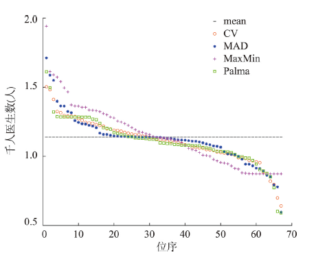
图7
部分模型优化可达性的降序分布对比
Fig. 7
Distribution of optimal accessibility in descending order of selected models
3.3 优化结果的空间分布
图8展示了CV、MAD和Palma 3个模型优化可达性的空间分布,类似地也加入了MaxMin模型的结果作为参照。图8中均以可达性的加权平均值加减标准差作为分段值。在CV、MAD和Palma 3个模型的结果中,大部分街道单元的优化可达性都位于可达性加权平均值加减标准差的取值范围内,可达性空间公平程度较高。此外,3个模型中的可达性高值和低值区较为一致,反映出模型优化结果的稳定性。其中,高值区可能是由于现状医疗设施较密集、交通可达性较好;而低值区则相反,需要新建医疗设施或改善交通条件才能进一步提升医疗服务可达性。在3个模型中,Palma模型优化结果中的高值区和低值区最少。作为对比,在MaxMin模型结果中高值区和低值区都较多,对空间公平的优化效果较差。
图8
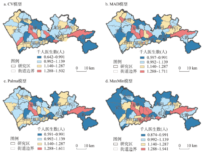
图8
部分模型优化可达性的空间分布
Fig. 8
Spatial distribution of optimal accessibility of selected models
4 结论与讨论
空间公平导向的设施优化配置模型是地理学参与基本公共服务均等化战略的重要途径,最大可达性均等(MAE)模型是该领域的重要方法进展。但目前MAE模型应用中主要是基于方差指标,对于其他空间公平测度指标的探讨仍较缺乏,使得优化配置模型的理论基础和科学性均较薄弱。本文系统梳理了国内外研究中提出的空间公平测度指标,从医疗服务空间公平的角度对这些指标的内涵进行了分析,并以深圳市医疗设施为例对基于这些指标的MAE模型进行了应用和综合比较评估,以识别出综合优化效果较好的空间公平测度指标和优化模型。模型构建涉及的可达性、空间公平等关键概念对于医疗设施以外的其他类型点状公共服务设施也具有通用性,因此研究中对MAE模型的改进对于其他公共服务设施优化配置也具有应用前景。
(1)从空间公平内涵来看,方差、标准差、变异系数、基尼系数、平均绝对偏差和泰尔指数等指标都考虑了每个空间单元的可达性差异程度,能够较好地从可达性总体差异的角度反映公共服务空间公平。但这些指标对差异程度的衡量方式不同:方差、标准差和变异系数都依赖于可达性差异的平方项,因此对可达性高值和低值较为敏感;平均绝对偏差指标采用绝对值计算来衡量可达性差异,对可达性差异的敏感性较为适中;基尼系数指标对任意两个单元间的可达性差异都予以考虑,是收入差距等社会经济领域公平性研究中最常用的指标;泰尔指数基于信息论方法来衡量可达性差异,但评价结果的现实含义不易于理解。此外,帕尔玛比值虽然没有考虑所有空间单元,但考虑最关键的两部分空间单元(即可达性水平前10%和后40%单元)的可达性情况,因此也能较好反映公共服务的空间公平。最后,最大偏差、值域和最小值最大化3个指标只考虑可达性的极值情况,对所有空间单元可达性差异的考虑较为片面,适用于某些特殊的应用情景。总体而言,根据指标内涵方面的讨论,本文建议变异系数、基尼系数、平均绝对偏差和帕尔玛比值等4个指标较为适用于公共服务的空间公平优化研究。
(2)通过优化设施规模和可达性分布、相关系数和优化结果交叉评估等角度,对10个优化模型的实际效果进行了综合比较。总体而言,基于方差、标准差、变异系数、帕尔玛比值、平均绝对偏差和泰尔指数的MAE模型表现较好,基于最小值最大化指标的模型表现明显差于其他模型。
综合上述两个方面的优势,本文认为变异系数、平均绝对偏差和帕尔玛比值3个指标的综合表现最好,能够较好地测度公共服务可达性空间公平,基于这3个指标的最大可达性均等模型能够得到较好的优化效果,明显提升公共服务可达性的空间公平性。以这3个指标替换传统MAE模型中作为目标函数的方差指标,可以得到优化效果更好的改进MAE模型。表3中总结了3个改进模型的表达形式和优势。
表3 建议的3个改进MAE模型
Tab. 3
| 模型名称 | CV-MAE模型 | MAD-MAE模型 | Palma-MAE模型 |
|---|---|---|---|
| 目标函数 | Minimize | Minimize | Minimize |
| 可达性模型 | |||
| 决策变量 | Sj | Sj | Sj |
| 约束条件 | Sj取值区间; 资源总量 | Sj取值区间; 资源总量 | Sj取值区间; 资源总量 |
| 模型优势 | CV指标消除了可达性量纲影响,应用于不同案例时具有一定可比性;是常用的差异测度指标;对可达性高值和低值的优化效果较好 | MAD指标与可达性量纲一致;对可达性差异的敏感性较为适中,对中间段大部分单元的公平性优化效果较好;表达形式和含义较简单 | 帕尔玛指标是目前收入研究中流行的指标;考虑最好和最差的一部分人群之间的差距,对于社会公平有较为直接但有效的反映;易于理解 |
如前所述,空间公平是一个难以统一定义的概念,在学术讨论中也仍存在不同观点。本文着重从不同地区可达性总体差异的角度来测度公共服务空间公平。在分析的10个空间公平测度指标中,也有一些指标关注可达性极值对空间公平的影响,如最大偏差、值域和最小值最大化指标。但根据模型效果评估,这3个指标虽然较好地优化了可达性极值,但对于可达性总体差异的优化效果相对其他指标更差。尽管如此,不同空间公平测度指标可能适用于不同政策情景,对多个指标进行组合运用也可能提升综合优化效果,对于这些问题还需更深入的研究来探讨。
此外,本文也还存在一些不足:① 本文仅针对深圳市医疗设施案例进行了模型应用与比较,研究结论对于其他地区或其他类型设施是否具有普适性还需后续研究的进一步验证。② 虽然本文中考虑了已有研究中10种讨论较多的空间公平测度指标,但还有一些指标尚未涉及,在后续研究中有待进一步补充。③ 本文的主要目的是进行模型比较,因此优化情景设置较为简单,后续研究需进一步完善优化情景设置,以更好地与公共服务设施规划实践相结合。④ 本文关注了可达性的空间公平,对于公平内涵的反映仍局限于机会公平,后续研究应进一步关注公共服务的结果公平。
参考文献
Measurement, optimization and impact of health care accessibility: A methodological review
DOI:10.1080/00045608.2012.657146 URL [本文引用: 6]
Spatial optimization in geography
DOI:10.1080/00045608.2012.685044 URL [本文引用: 1]
Research progress and its enlightenment of urban public service facilities allocation
DOI:10.18306/dlkxjz.2019.04.004
[本文引用: 1]

Public service facilities are the essential part of both harmonious livable city construction and people's desire for a better life in China. Our findings show the research topics regarding public service facilities allocation varies at home and abroad. English literature focuses mainly on the location choice, accessibility, spatial equity and social economic effects of public service facilities allocation, while domestic studies pay enormous attention to the optimized layout, accessibility, spatial patterns, social differentiation, residents' needs and satisfaction, as well as influencing factors of public service facilities allocation. Combining the prior domestic and foreign research, future studies in China should be more concerned with spatial distribution regularities, social equity, performance evaluation and spatial optimization of public service facilities allocation. By reviewing the related research progress at home and abroad, this study can contribute to promoting both theory ascension and scientific practice of urban public service facilities allocation in China.
城市公共服务设施配置研究进展及趋向
DOI:10.18306/dlkxjz.2019.04.004
[本文引用: 1]
公共服务设施是中国和谐宜居城市建设与人民美好生活愿望的重要构成。国内外城市公共服务设施配置的研究主题有所差异,国外研究主要关注公共服务设施配置的区位选择、可达性、空间公平和社会经济效应等方面,国内研究更加重视公共服务设施配置的优化布局、可达性、空间格局、社会分异、居民需求和满意度以及配置影响因素等内容。结合国内外研究现状的评析,论文认为中国城市公共服务设施配置研究需要加强公共服务设施配置的空间规律、社会公平、绩效评价和空间优化等方向研究。通过对国内外城市公共服务设施配置研究进展的理论总结与评述,以期促进中国城市公共服务设施配置的理论提升与科学实践。
Mapping the inequalities of medical resource provision in China
DOI:10.1080/21681376.2020.1848615 URL [本文引用: 1]
On the spatial allocation of the quantity and diversity of basic urban public service facilities: A case study of Wuhan inner city
城市基本公服设施数量与多样性空间配置研究: 以武汉市主城区为例
The spatial pattern and effect of basic public service quality in Henan Province
DOI:10.13249/j.cnki.sgs.2016.10.006
[本文引用: 1]
Basic public service is the foundation of maintaining social fairness and justice. It is of significance to build a comprehensively well-off society by establishing and perfecting the basic public service system and promoting the equal basic public service. By establishing the evaluation system of basic public service, this article evaluated the level of basic public service in Henan Province, then analyzed the spatial pattern of basic public service quality by using the spatial autocorrelation method, and finally studied the spatial spillover effects and the influence factors of basic public service by using Spatial Durbin Model. The results show that, 1) The level of basic public service quality in cities of Henan Province shows the different rising trend during 2005-2013, but the overall level remains to be improved. The relative difference among cities shows the trend of shrinking. The low level area shows obvious “catch-up effect” to high level area. 2) The spatial pattern of basic public service shows the structure of half band characteristics and the level of basic public service decreases from northwest to southeast. From the global trend, the basic public service level in west area is higher than the east area, the north area is superior to the south area and the latitudinal direction difference is less than the east-west differences. Compared with sub-region in Henan Province, the level of the Central Plains Urban Agglomeration is the highest, the level of the western and southwest region and the northern region is the higher, and the level of Huanghuai region is the lowest. 3) The global Moran’s index during 2005-2013 is positive. The spatial pattern of basic public service shows the positive spatial correlation. The various types of basic public service show the spatial evolution mode of agglomeration-dispersion-agglomeration. The local auto-correlation results show that the spatial club convergence characteristics of High-High and Low-Low agglomeration is obvious. The distribution and amount of various agglomeration types remain stable. 4) The spatial Durbin Model test shows that there exists spatial spillover effects of basic public service among cities in Henan Province. The level of regional basic public service is not only influenced by the region itself factors, also affected by the basic public service level of adjacent areas. The regression results show that the urbanization level, local financial expenditure and regional economic vitality have a positive influence on the basic public service.
河南省基本公共服务质量空间格局与空间效应研究
DOI:10.13249/j.cnki.sgs.2016.10.006
[本文引用: 1]
构建基本公共服务质量评价指标体系,对河南省基本公共服务水平和空间格局特征进行了分析,最后采用空间杜宾模型研究了基本公共服务的空间溢出效应与影响因素。研究发现:① 2005~2014年河南省各市基本公共服务水平呈不同程度的上升趋势,但整体水平不高;空间格局上呈自西北向东南衰减的半环带圈层结构。② 基本公共服务在市际尺度上具有显著的全局与局部自相关特征,随时间呈现集聚-分散-集聚的演变模式;高高集聚与低低集聚的空间俱乐部趋同特征明显。③ 空间杜宾模型检验表明基本公共服务空间上存在溢出效应;城镇化水平、地方政府财政支出能力、地方经济发展活力对基本公共服务具有正向促进作用。
Spatio-temporal characteristics and evolution mechanism for the equalization of basic public service in island counties of China
中国海岛县基本公共服务均等化时空特征及其演化机理
Analysis of the spatial structure, mechanism and social-political effects of the high-quality basic educational resources in China
DOI:10.11821/dlxb202002008
[本文引用: 1]
Education is not only important for strengthening a country's population quality and comprehensive power but key in reshaping the "man-land" relations in a country. This article reviews studies on the distribution of educational resources in both Chinese and Anglophone literature and summarizes the research gaps in the Chinese literature, which include but are not limited to the downplay of the analysis of mechanism and comprehensive effects of the spatial structure of educational resources. Employing different map-making technologies and mechanism-analysis methods, this article dives into three findings. First, though spatial features are slightly different between primary school level and middle school level, eastern regions generally have higher quality educational resources than western regions. In addition, urban agglomeration, including Beijing-Tianjin-Hebei, Shanghai-Ningbo-Hangzhou, and the Pearl River Delta, have an advantage in attracting and cultivating high-quality educational resources. Second, the quantity of high-quality primary school resources is positively correlated with annual per capita disposable income of urban households and number of full-time primary school teachers. The quantity of high-quality middle school resources is positively correlated with the comprehensive economic and social performance of the city. Third, when affected by multiple mechanisms, the spatial structure of China's high-quality educational resources is dynamic and deeply intertwines with the interrelations between cities as well as between the societies within each city. This article contributes both to the understanding of the unequal spatial structure of high-quality educational resources in China and to the analysis of complex socio-political effects on this transforming structure. Its findings encourage further research on the connection between the spatial structure of a region's educational resources and its cooperation and geopolitics as well as on the resulting social mobility among different social strata. Study limitations include: place-related elements, such as local political resources, were not sufficiently considered when selecting factors; there is a lack of longitudinal analysis; and not enough attention is paid to the combination of number-based data and geo-information-based data in analyses.
中国优质基础教育资源空间格局形成机制及综合效应
DOI:10.11821/dlxb202002008
[本文引用: 1]
教育关乎一个国家人口素质的提升和综合实力的发展,也是塑造国家和地区人地关系的重要因素。通过回顾并反思中西方人文地理学视角下的教育资源配置研究,总结当前中国相关研究的不足。借鉴当前西方教育资源空间格局研究中所采取的“资源格局—影响机制—社会效应”的主流路径,本文利用多种空间分析和机制研究方法,对中国优质基础教育资源空间格局、形成机制和综合效应进行了分析。研究发现:① 优质小学基础教育资源和优质中学教育资源的区域格局和强度虽各有差异,但都体现出不平衡的发展特征,特别是在区域尺度上,体现出明显的东西部差异。此外,中国几大城市群,如京津冀,沪宁杭,珠三角,武汉都市圈以及成渝都市圈等,是优质基础教育资源的优势区域;② 优质小学教育资源的形成和规模增长与城市居民经济自由度以及城市专任教师规模两个因素高度相关;优质中学教育资源的形成和规模增长和城市本底经济社会发展水平因素高度相关;③ 在多元相关机制作用下,中国优质教育资源空间结构在当下及未来必定处于复杂动态变化之中,并将更为深刻地塑造着城市与城市、城市与社会之间的互动关系。本文有助于理解中国优质教育资源空间结构不平衡的现状,同时反思和探索教育资源结构所蕴含和产生的政治意义和社会影响。
Spatial equity and influences of two-level public healthcare resources: A background to hierarchical diagnosis and treatment reform in China
DOI:10.11821/dlxb201906008
[本文引用: 1]
In present-day China, the unequal distribution of public healthcare resources across different levels and regions is problematic. Hierarchical diagnosis and treatment (HDT) reform is of great significance for optimising the distribution of healthcare resources and promoting fairness across health services. In this study, exploratory spatial data analysis (ESDA) was applied to evaluate spatial patterns at the lower and upper levels of healthcare resources. The Geodetector model was used to analyse the influences of the healthcare system at the municipal and county levels during 2015. The results show that there is significant spatial clustering in the distribution of the two-level healthcare resources. Influences on upper-level healthcare resources are more significant than those on lower levels. The dominant influencing factors of the two-level healthcare resources differ across spatial scales and regions. In terms of upper-level healthcare resources, urbanisation, population density and the level of economic development are the dominant global factors, in addition to the regional factors of population aging, topography and the morbidity of epidemic and endemic diseases. In the case of lower-level healthcare resources, urbanisation is an important influencing factor, while economic development, population aging and morbidity have local effects. Ultimately, population density was the dominant factor. Finally, this paper suggests that, aiming for HDT reform, decision makers should allocate healthcare resources among different regions and levels in consideration of relevant global and local factors, united and targeted policies, and top-down and bottom-up decision-making mechanisms. This could promote the overall function of the healthcare system and enhance the equity and coordination of multi-level healthcare resources.
两层级公共医疗资源空间均衡性及其影响机制: 以分级诊疗改革为背景
DOI:10.11821/dlxb201906008
[本文引用: 1]
中国公共医疗资源在层级间和地区间配置不合理的问题较为突出。分级诊疗改革对优化医疗资源配置、实现供需均衡具有重要意义。运用探索性空间分析法和地理探测器分别从全国地级市域和四川县域两个尺度分析了2015年两层级医疗资源的空间配置特征与影响机制。结果表明:基层和上层医疗资源均呈显著空间聚集特征,而层级间空间配置格局具有差异性。不同尺度和区域两层级医疗资源配置的决定力及其影响强度不同,上层医疗资源对外部影响因素响应强度大于基层。对上层级医疗资源配置而言,城镇化率、人口密度、经济发展水平是全局性因素,老龄化、地形条件和发病率为地方性因素;对基层医疗资源配置而言,人口密度是较为显著的全局性影响因素,城镇化率是重要的地方性影响因素,地形、经济发展水平、人口老龄化和发病率在部分尺度和区域有局部影响。为实现分级诊疗改革的目标,各级决策部门需以“全局性和地域性因素相结合,统一性和地方性政策相结合,自上而下与自下而上决策机制相结合”为思路,统筹不同区域和层级医疗资源配置,以提高医疗卫生服务体系的整体功能,促进其均衡、协同发展。
Spatial accessibility to public service facilities and its measurement approaches
DOI:10.11820/dlkxjz.2010.10.009
[本文引用: 2]
Spatial accessibility measurement can be applied to assess the rationality of public service facilities distribution, and can be used to compare the merits and drawbacks of related planning schemes. As for spatial accessibility measurement to public service facilities, the primary issue is to select corresponding accessibility evaluation factors according to specific spatial distribution targets of various facilities presumed by facilities features and service demands, and the next is to apply appropriate accessibility measurement approaches according to the evaluation factors and to achieve the accessibility calculation. However, it is unlucky that the present literature on such thematic studies is scarce. On the one hand, we analyze the classification to public service facilities from the perspectives of service urgency, acceptability, quantity (single or various) and hierarchic rank, and then we discuss how to presume spatial distribution targets and select corresponding accessibility evaluation factors of different facilities. On the other hand, we introduce the main measurement approaches including the methods based on supply (provider) versus demand (population), the shortest travel impedance (time or distance), opportunities to be accumulated, and spatial interaction, and furthermore we compare the applications as well as the merits and drawbacks of various approaches, and discuss how to measure spatial accessibility of public service facilities based on potential model and two-step floating catchment area method. Finally, based on the above review and summary, we point out that the following research topics should be devoted more attention to: the spatial accessibility measurement to hierarchical facilities, comprehensive examination of the spatial accessibility measurement from the point of view of demanders activities, integrated spatial accessibility measurement to multiple facilities in the study area, and the integration between complicated measure approaches and GIS.
公共服务设施空间可达性及其度量方法
DOI:10.11820/dlkxjz.2010.10.009
[本文引用: 2]
空间可达性度量既可用于评价公共服务设施空间布局的合理性,也可用于比较规划方案的优劣。公共服务设施空间可达性度量需要针对不同设施特有的空间布局目标,选取与之相适应的可达性评价因子,并采用合适的度量方法展开,对此进行专题研究的文献并不多见。本文一方面在对公共服务设施按照时效性、接受性、数量、等级性进行分类的基础上,系统阐述如何针对不同设施进行空间布局目标设定和可达性评价因子选取;另一方面将主要的度量方法分为比例法、最近距离法、基于机会累积的方法、基于空间相互作用的方法,并对各类方法的应用领域及优缺点予以分析比较,同时以潜能模型、两步移动搜寻法为例探讨相关方法在公共服务设施空间可达性度量中的应用;最后在对上述研究总结评述的基础上,本文指出多等级设施空间可达性、从需求者的活动规律考虑空间可达性、针对各类设施的综合空间可达性以及相关度量方法与GIS的集成等主题值得投入更多关注。
Public transit accessibility approach to understand the equity for public healthcare services: A case study of Greater Mumbai
Research progress of the two-step floating catchment area method and extensions
DOI:10.18306/dlkxjz.2016.05.006
[本文引用: 4]
Two-step floating catchment area (2SFCA) method is an important method of research on spatial accessibility to public services, which has been widely applied in studies on the spatial layout of public service facilities. Various extensions of 2SFCA have been developed. However, the application of the 2SFCA method and especially its extensions is still very limited in China. Thus, this study systematically summarizes the major extensions of the 2SFCA method. Such extensions found in existing literature can be classified into four categories. The first category focuses on the distance-decay function, replacing the dichotomous distance-decay form of the original 2SFCA by a multilevel discrete form as in the Enhanced 2SFCA, or continuous forms such as in the gravity-style, Gaussian-style, and Kernel-density-style distance-decay functions. The second category deals with the delimitation of catchment areas. The original 2SFCA form adopts a buffer-ring (BR) method delineating the catchment areas as concentric circles with certain radii of physical distance or travel time. A number of extensions have improved the BR method, including the Variable 2SFCA, the Dynamic 2SFCA, and the Multi Catchment Sizes 2SFCA. Moreover, a novel nearest-neighbor (NN) method for delineating the catchment areas by identifying a finite number of nearest facilities for each demand node has been proposed. The third category strives to improve the accuracy of 2SFCA by accounting for the competition among demand nodes or among supply nodes. The initial extension of this category is the Three-step Floating Catchment Area (3SFCA) method, following which other extensions such as the Modified 2SFCA and the Huff 2SFCA are proposed to make further improvements. The fourth category extends the travel means of the demand side, including the Multi-mode 2SFCA taking into account various potential transportation modes, and the Commuter-based 2SFCA integrating service visits and commuting behavior. The advantages and disadvantages, scenarios appropriate for their application, and potential improvements in the future of these extensions are also discussed. This study can contribute to the choice of method in relevant studies and promote the implementation and development of the 2SFCA method and extensions in relevant research fields in China.
两步移动搜寻法及其扩展形式研究进展
DOI:10.18306/dlkxjz.2016.05.006
[本文引用: 4]
两步移动搜寻法是公共服务设施空间可达性研究中的重要方法,在国内外公共服务设施布局研究中得到了广泛应用,且发展出了众多扩展形式。但国内研究中对两步移动搜寻法尤其是其扩展形式的应用还较为有限。本文对两步移动搜寻法的主要扩展形式进行系统梳理和总结,将国内外研究中提出的两步移动搜寻法扩展形式归纳为基于引入距离衰减函数的扩展、对搜寻半径的扩展、针对需求或供给竞争的扩展以及基于出行方式的扩展4类,并分析了各种扩展形式的优缺点、适用情景以及未来可能改进方向。旨在为相关研究的方法选择提供参考,促进两步移动搜寻法及其扩展形式在国内相关领域的应用和发展。
Strategic facility location: A review
DOI:10.1016/S0377-2217(98)00186-6 URL [本文引用: 1]
Evaluation, optimization and simulation of the spatial layout of transport hubs in China
DOI:10.11821/xb201104007
[本文引用: 1]
Transport hubs are important elements of an integrated transportation system. How to locate transport hubs rationally has great significance to construct an efficient integrated transportation system. The layout optimization of transport hubs has been a focus field of transportation engineering and transportation geography. However, the current research on transport hubs' layout has limits to one single transport mode and has not considered the integration of all transport modes. As a result, the transport hubs' construction has the problem of fragmentation, duplication and even contradictory. Based on regional comprehensive transport hubs, this paper designs a series of indices, composed of 20 indicators. All these 20 indicators belong to three categories: transport network, passenger and freight traffic, and socio-economic development. The basic unit is 337 prefecture-level cities, and the maximum coverage model is adopted (one of the spatial layout optimization models). Under the condition of limited space, the model tries to find a way to locate infrastructure with the aim of making people as many as possible enjoy infrastructure service in a certain distance. First, this paper evaluates the potential of the 337 prefecture level cities for being comprehensive transport hubs with the maximum coverage model, and then identifies the optimal number of comprehensive transport hubs and their spatial distribution with the service radius of 80 km, 120 km, 160 km and 200 km separately. Second, the paper summarizes the general rules between the number of transport hubs and the objective values, and finally chooses 42 transport hubs for China. Third, this paper divides the hierarchy of the 42 transport hubs and simulates their spatial effect of area, population, and GDP, and the result shows better than that of the comprehensive transport hubs by national planning.
中国交通枢纽空间布局的评价、优化与模拟
Space operation of rural primary and secondary school location
DOI:10.11821/dlxb201310010
[本文引用: 2]
The location of the primary and secondary schools has a great significance on ensuring the safety and convenience when students attending and leaving schools. Many previous researches have proposed school location-allocation models, but the models are not suitable for rural schools. In this manuscript, we improve the P-median model by fully considering the advantages of P-center model and P-median model. A maximum distance constraint between students' home and school are coupled into the original P-median model. Thus, the improved P-median model owns the advantages of both P-center model and P-median model, i.e. ensuring the convenience for students from remote rural areas, and minimizing the sum of weighted distance. In order to facilitate the model application, an decision support system based on our newly derived vertex substitution search algorithm for allocating optimal location of rural elementary and secondary school were developed on the ArcGIS Engine development component library and Visual Studio development platform. Afterwards, a town of Shandong province is taken as a system test case. The school location selected by our system is better than the locations selected by traditional P-median model. The results prove that the improved P-center model can supply a reference for allocating the location of elementary and secondary school.
农村中小学选址的空间运筹
DOI:10.11821/dlxb201310010
[本文引用: 2]
农村中小学的选址问题是当前地理学区位理论应用的一个热点,学校作为一个设施对学生上学安全和便捷程度有很大影响。许多学者研究了学校的区位问题,然而对农村地区来说,采用模型不够适合。本文学校选址研究充分考虑P-重心模型和P-中心模型的优缺点,在P-重心模型的基础上对模型进行改进,增加学生上学最大距离不超过某一阈值的约束,这样改进后的模型同时具有P-中心和P-重心模型的优点,既保证农村偏远地区的学生上学相对方便,又保证加权距离和相对最小。为了方便应用,应用地理信息科学方法,使用改进的节点交换搜索算法求解,然后通过Visual Studio 开发平台和ArcGIS Engine 二次开发组件库开发了农村中小学最优选址的决策支持系统。最后以山东省某镇为例,用该系统解决该镇的小学选址,结果发现改进后同时具有P-重心和P-中心特性的模型比传统的P-重心模型更能适合农村小学选址,能够作为小学学校规划选址的辅助决策依据。
Optimum locations of switching centers and the absolute centers and medians of a graph
DOI:10.1287/opre.12.3.450 URL [本文引用: 1]
Maximal coverage location problem
DOI:10.1177/0160017615600222 URL [本文引用: 1]
Stratified estimation of the total number and location of Chinese civil airports based on population coverage using revised LSCP and MCLP models
DOI:10.11820/dlkxjz.2014.12.007
[本文引用: 1]
Determining the appropriate number of civil airports is an important topic in Chinese civil airport planning and development. Qualitative estimation of the number of airports cannot meet the requirement of future planning, thus appropriate quantitative methods are needed for providing sound support for decision making. According to the different accessibility requirements of various demand points, this paper defines different accessibility thresholds for different levels of airports, sets the minimum number of population that an airport should serve, and utilizes the revised Location Set Covering Problem (LSCP) and Maximal Covering Location Problem (MCLP) models for the stratified estimation of the total number and location of Chinese civil airports. The result reveals that to cover 95% of the total population within 100 km rectilinear distance, the required number of airports is 370~385. In the central and western regions, city-and county-level airports are all required. City-level airports need to be constructed in northeast China and there should be a number of new county-level airports in Heilongjiang Province. In the eastern region, seldom any city-level airports but some county-level airports are demanded. The result that some cities do not need new airports in the city-level estimation but the counties under these cities need one or more new airports in the county-level estimation may seem counter intuitive, but this research found that this result is reasonable. The result is heuristic for future civil airport planning.
中国机场总规模分层优化测算研究: 基于人口覆盖角度
DOI:10.11820/dlkxjz.2014.12.007
[本文引用: 1]
适宜的机场数量规模是中国机场发展战略和中长期规划的重要研究内容。传统的定性方法难以满足规划的需求,而采用合理的定量测算方法求解中国机场规模对未来的规划更具有参考意义。本文根据不同等级需求点的可达性要求,设置不同的机场服务半径,并规定新建机场腹地人口规模,通过制定位置集合覆盖模型(Location Set Covering Problem,LSCP)和最大覆盖选址模型(Maximal Covering Location Problem, MCLP)的综合修正模型,对中国机场规模进行分层测算。结果表明,不同地、县级需求组合下,在地面道路距离100 km范围内覆盖中国95%总人口时,中国机场规模以370~385个为宜。其中,中部、西部地区地级机场与县级机场均需建设;东北地区需要多新建地级机场,黑龙江省还需新建少量县级机场;东部地区新建少量地级机场以及适量县级机场。对于本文结果中出现的首层地级测算中地级市没有布局机场,但在第二层县级测算时下属县却布局机场,以及同一地级市布局多个县级机场的现象,认为是合理的。测算结果对未来民航机场规划具有一定参考价值。
Planning toward equal accessibility to services: A quadratic programming approach
DOI:10.1068/b37096 URL [本文引用: 7]
Spatial optimization and planning practice towards equal access of public services
公共资源公平配置的规划方法与实践
Research progress and prospect of public service facilities layout optimization models
公共服务设施布局优化模型研究进展与展望
Social justice and spatial inequality
DOI:10.1177/0309132517702969 URL [本文引用: 1]
Research on equalized layout of urban and rural public facilities: A case study of educational facilities in Changzhou
城乡基本公共服务设施布局均等化研究: 以常州市教育设施为例
Spatial optimization of residential care facility locations in Beijing, China: Maximum equity in accessibility
Spatial optimization of residential care facility locations in 2020 in Beijing: Maximum equity in accessibility
DOI:10.18306/dlkxjz.2015.12.009
[本文引用: 3]
Beijing is facing rapid population aging. Residential care plays an increasingly important role in the care for the elderly people. It is of great importance to optimize the layout of residential care facilities to ensure equal and reasonable access, which has scientific and practical implications. This study first forecasted the spatial distribution of the elderly population under natural growth in 2020 in Beijing. Second, a spatial optimization model was established to maximize equity in access to residential care facilities. The Particle Swarm Optimization algorithm was used to solve the optimization model. As the results show, the elderly population aged 60 or older will reach 4.37 million in 2020 in Beijing, among which 7.9%, 50.2%, 30.1%, and 11.8% of the total elderly population will be located in the Capital Core Functional Area, Urban Functional Extension Area, Urban New Developing Area, and Ecological Protection Area, respectively. By contrast, 2.7%, 32.7%, 48.5%, and 16.1% of the total residential care facility (RCF) beds will be located in the Capital Core Functional Area, Urban Functional Extension Area, Urban New Developing Area, and Ecological Protection Area, respectively when optimized. The optimized RCF layouts improve spatially equal access to residential care resources with very low accessibility standard variation (0.0026), while the accessibility standard variation of actual layouts is 8 times (0.0207) that of the optimized results. In the layouts with maximum equity in access, only a portion of the demands for residential care in the Capital Core Functional Area and Urban Functional Extension Area will be met locally. The residential care resources in the Urban New Developing Area will meet both the local demands and the demands from the two functional areas in the central city. The Ecological Protection Area, however, mainly provides residential care services for the local elderly population. The optimized results of this study correspond to the “Special Plan for the Development of Residential Care Facilities in Beijing,” which also conforms to the reality that the land resources are in shortage in the central city and the physical environment in the suburb is more pleasant for the elderly people. The results of this study will support knowledge-based policy-making and planning of residential care facilities. The methods introduced in this study can also be applied to the spatial optimization of other types of public service facilities.
基于公平最大化目标的2020年北京市养老设施布局优化
DOI:10.18306/dlkxjz.2015.12.009
[本文引用: 3]
北京市正快速步入老龄化社会,机构养老作为一种重要的养老模式,对其布局公平性和合理性的研究具有重要的科学和现实意义。本文首先预测了自然增长状态下2020年北京市老龄人口的空间分布,然后建立设施布局优化模型,该模型以各需求点到养老设施的可达性差异最小化为目标;并采用粒子群优化算法求解,对北京市养老设施进行以公平最大化为目标的布局优化。研究结果表明,在公平最大化的目标下,首都功能核心区和城市功能拓展区(即中心城区)所提供的机构养老资源不能完全满足本地需求。城市发展新区在满足当地的机构养老需求之外,还将为中心城区提供大量机构养老服务,生态涵养发展区在满足本地需求的基础上还可为其他地区提供少量机构养老服务。该布局导向与《北京市养老设施专项规划》提出的布局建议相一致,且符合中心城区用地紧张、郊区自然环境较舒适的现实情况。研究结果能为养老政策的制定提供科学建议,所采用的方法也能为其他类型公共服务设施的布局优化提供借鉴。
A two-step approach to planning new facilities towards equal accessibility
DOI:10.1177/0265813516657083 URL [本文引用: 3]
Two-step optimization for spatial accessibility improvement: A case study of health care planning in rural China
Secondary school allocation optimization towards equal access: A case study on Shijingshan District
公平导向的学校分配空间优化: 以北京石景山区为例
DOI:10.11821/dlxb201708011
[本文引用: 2]
空间优化正从地理学的一个研究方向成为学科分支,但公平导向的公共服务空间分配优化研究还较薄弱。学区配置是这方面的一个典型问题,受到社会的广泛关注。针对“多校划片”的随机入学方式,以各居住小区所获得的教育质量期望值的方差来定义入学指标空间分配的公平程度,构建了以该方差最小化为目标、包含最大上学距离约束的二次规划模型,探求各小区对所获得指标进行随机抽签的情景下,各校入学指标在各小区的公平最大化分配,并以北京市石景山区为案例进行了应用研究。结果表明,在维持学校布局和师资配置现状的前提下,与“就近入学”相比,公平最大化的“多校划片”能以有限的上学距离代价,显著降低教育分配的空间差异。在最大上学距离为5 km的约束下,各小区教育质量期望值的方差降幅高达99%,教育质量期望值有所提升的小区或学生比例高达约2/3;付出的上学距离代价较显著但可接受,平均上学距离增加到3.99倍,达到3.20 km,仍低于案例区实际平均上学距离。当模型的最大上学距离参数从5 km逐步增至8 km时,教育公平的改善呈指数增长,平均上学距离呈算数增长;当距离为7 km时,各小区教育质量期望值的方差趋近于0,可基本实现上学机会的空间均等化。本文进一步讨论了优化结果对入学政策的启示。
Optimizing the spatial assignment of schools through a random mechanism towards equal educational opportunity: A resemblance approach
DOI:10.1016/j.compenvurbsys.2019.03.003 URL [本文引用: 1]
Optimizing the spatial assignment of schools to reduce both inequality of educational opportunity and potential opposition rate through introducing random mechanism into proximity-based system
Equalizing the spatial accessibility of emergency medical services in Shanghai: A trade-off perspective
Equality measures properties for location problems
DOI:10.1007/s11590-015-0968-2 URL [本文引用: 2]
Inequality measures and equitable locations
DOI:10.1007/s10479-007-0234-9 URL [本文引用: 3]
Regional inequality measurement: Methods and evaluations
区域差异测度方法与评价
Spatial difference analysis for accessibility to high level hospitals based on travel time in Shenzhen, China
DOI:10.1016/j.habitatint.2015.12.023 URL [本文引用: 1]
Evaluating the spatial accessibility and distribution balance of multi-level medical service facilities
Investigating the impacts of public transport on job accessibility in Shenzhen, China: A multi-modal approach
Accessibility evaluation of land-use and transport strategies: Review and research directions
DOI:10.1016/j.jtrangeo.2003.10.005 URL [本文引用: 1]
Black residential segregation, disparities in spatial access to health care facilities, and late-stage breast cancer diagnosis in metropolitan Detroit
An enhanced two-step floating catchment area (E2SFCA) method for measuring spatial accessibility to primary care physicians
Measures of spatial accessibility to healthcare in a GIS environment: Synthesis and a case study in Chicago region
Location characteristics of inner-city neighborhoods and employment accessibility of low-wage workers
DOI:10.1068/b250345 URL [本文引用: 1]
Integrating socioeconomic status and spatial factors to improve the accessibility of community care resources using maximum-equity optimization of supply capacity allocation
Equity and equality in health and health care
DOI:10.1016/0167-6296(93)90004-x
PMID:10131755
[本文引用: 3]
This paper explores four definitions of equity in health care: equality of utilization, distribution according to need, equality of access, and equality of health. We argue that the definitions of 'need' in the literature are inadequate and propose a new definition. We also argue that, irrespective of how need and access are defined, the four definitions of equity are, in general, mutually incompatible. In contrast to previous authors, we suggest that equality of health should be the dominant principle and that equity in health care should therefore entail distributing care in such a way as to get as close as is feasible to an equal distribution of health.
How can the spatial equity of health services be defined and measured? A systematic review of spatial equity definitions and methods
Associations between spatial access to medical facilities and health-seeking behaviors: A mixed geographically weighted regression analysis in Shanghai, China
Late-stage breast cancer diagnosis and health care access in Illinois
DOI:10.1080/00330120701724087 URL [本文引用: 1]
On the measurement of inequality
DOI:10.1016/0022-0531(70)90039-6 URL [本文引用: 1]
Homogeneous middles vs. heterogeneous tails, and the end of the 'inverted-U': It's all about the share of the rich
DOI:10.1111/j.1467-7660.2011.01694.x URL [本文引用: 1]
