

1 引言
改革开放以来,中国乡村为中国城镇化和创造世界经济奇迹作出了巨大贡献。新中国成立初期,为了加快国民经济建设、夯实工业基础,国家选择了城市偏向的赶超型重工业优先发展战略[1],通过工农业产品价格“剪刀差”、城乡劳动力“剪刀差”、城乡土地“剪刀差”等制度安排,以农业哺育工业、农村支持城市,完成了工业化和城镇化所需要的大量资本积累[2]。随着改革开放的深入推进,中国经济增长与社会发展开始步入统筹协调、全面发展的新轨道,工业化、城镇化进程加快,现代化建设水平和居民生活质量不断提高。进入21世纪,为了解决快速工业化和城镇化带来的工农关系、城乡关系不平衡不协调的矛盾,中央政府先后实施了“五个统筹”、“社会主义新农村建设”、城乡发展一体化、新型城镇化等战略[3]。但是,制约乡村发展的城乡二元体制和城市优先发展偏好依然存在,城乡发展不平衡、农业基础不牢固、“乡村病”日益严峻成为新时代乡村转型发展所面临的现实难题[4]。党的“十九大”审时度势,提出要建立健全城乡融合体制机制,坚持农业农村优先发展,实施乡村振兴战略,着力弥补全面建成小康社会的乡村短板,为新时期地理学服务支撑国家重大战略,研究破解“三农”问题指明了方向。
“三农”问题是中国基本国情的集中体现,是地理学长期研究的焦点和难点。早在1936年著名地理学家胡焕庸在省域和全国范围内开展了农业区域研究,将全国划分成9个农业区[5,6]。新中国成立后,秉持地理学为国民经济建设服务,特别是为农业服务的宗旨,以吴传钧、邓静中等为代表的老一辈地理学家开展了大量农业资源调查和农业地域类型研究,编制了全国及不同地区农业区划的初步方案[7,8,9,10,11,12]。改革开放后,1981年周立三主持完成了《中国综合农业区划》编制。该区划将全国划分成10个一级农业区、38个二级农业区,为制定国家农业发展中长期规划、优化农业生产布局做出了重要贡献。进入21世纪,随着工业化、城镇化的快速推进和农业产业化、市场化程度的不断提高,农业生产地域格局与功能发生了显著变化,刘彦随主持研制了《中国现代农业区划》方案,将全国农业地域类型划分成15个一级区、53个二级区[13]。从不同时期的区划结果看,全国农业分区日趋细化,反映了人类活动强度及其影响程度不断增大,农业地域结构及其变化的影响因素增多,农业生产格局及其功能的地域性、多样性显著增强。
随着城乡人口、土地、资金、技术等生产要素流动的不断增强,城乡关系及乡村社会经济结构发生了巨大变化,研究视角逐步从“农业”扩展到“乡村”,研究对象由“乡村地区问题”转向“乡村地域系统”。特别是2005年实施“新农村建设”国家战略以来,“三农”问题受到高度重视,面向国家战略需求的新农村建设地理学快速兴起[14],乡村地理学发展势头强劲,研究内容与主题丰富多样,主要包括乡村发展格局与类型[15]、乡村转型发展过程与机理[16,17,18]、乡村性评价[19]、乡村地域功能分化与演变[20,21,22]、乡村重构[23]、城乡融合与乡村振兴[24]等。但是,着眼于乡村地域系统类型及其分异规律的综合研究尚处于探索发展阶段,当前主要包括从乡村转型、经济发展水平视角,研究揭示乡村发展类型及区域差异[25,26],而着眼于资源禀赋状况、地理环境、社会与经济发展等综合视角进行乡村地域系统的深入研究亟需加强。在研究尺度上,现有研究主要从县域层面探讨了乡村地域类型[27],尚缺少全国层面的乡村地域系统区划研究,难以科学把握乡村地域系统类型及其空间分异规律,不利于支撑新时代乡村振兴国家战略的落实和落地。
乡村振兴实质上是乡村地域系统要素重组、空间重构、功能提升的系统性过程[4, 28]。乡村振兴战略着眼于根本解决农民、农村、农业“三农”问题,补齐乡村发展短板,促进城乡经济社会均衡发展和乡村充分发展。乡村振兴是乡村地域系统的全面振兴,但不是每个村都要振兴,也不是每个村域同时振兴。中国地域辽阔、要素复杂、类型多样,从沿海到内陆、从南方到北方的自然地理分异,以及各区域城乡空间格局的差异,决定了乡村地域系统类型的复杂多样性[4]。遵循不同地域类型区乡村发展的客观规律,把握乡村系统要素的地域分异特征,是实施乡村振兴战略,实现乡村可持续发展的客观要求[4]。在规划决策中致力于推进“五体乡村”,即田园综合体、生命共同体、村镇有机体、特色经济体、创业联合体的系统建设,是科学谋划、因地制宜、分类推进乡村振兴战略的现实需要。本文立足于乡村振兴战略的宏观背景,依据人地关系地域系统与人地系统科学理论,首次以全国39164个乡镇为单元,探究乡村地域系统格局及其可持续发展的制约因子,甄别中国乡村地域系统特征及其类型,为乡村振兴国家战略的落实和落地提供科学基础与决策支持。在人类活动及人地系统交互作用日益增强的新时期,着眼于地理学视角透析乡村地域系统类型及其空间分异规律,有助于深化人地关系地域系统的理论认知,有助于创新发展人地系统科学的理论与方法,更好地凸显地理学、地球科学服务国民经济建设的学科价值和重大战略意义。
2 研究依据与方法
2.1 理论基础
(1)人地系统科学。20世纪90年代初,著名地理学家吴传钧指出,地理学的研究核心是人地关系地域系统[29]。“人”指人类社会,包括人口、社会、经济等要素;“地”指地理环境,包括资源、环境等要素。在人地关系中,人具有主观能动性,可以主动认识、利用并改造地理环境;“地”是人类赖以生存的物质基础和空间载体,地理环境制约着人类社会经济活动的深度、广度和速度。从人地协调论的视角来看,人地关系既会随着科学技术和生产力水平的提高而日益密切,也会由于特定地域自然、社会、经济条件的差异而发生改变,致使人地系统不断处于协调—失衡—再协调的动态演变中,同时人地关系具有地域差异性,仅当人类社会尊重自然,与自然和谐共生,才能形成协调的人地关系[30]。当代经济全球化、快速工业化、城镇化过程,已经或正在强烈地作用于地球表层人地系统,使地表自然、经济、社会、技术等多要素耦合,以及物理、化学、生物、人文等多过程作用更加强烈,并聚焦于人地系统融合与交互作用的地表新圈层——“人地圈”。较相对单一的自然圈层、生物圈层(人类圈),“人地圈”是现代人类活动与其赖以生存和发展的地表环境相互联系、交互作用、耦合渗透而形成的自然—经济—技术综合体,它更能凸显地表人地系统演化的耦合性、综合性与复杂性。面向人类世(Anthropocene)、立足“人地圈”,创新发展人地系统科学或现代人地系统学,将为深度解析现代人文技术作用过程、地表环境演变进程及其地域分异格局提供了科学认知基础。
(2)乡村地域系统。人类活动在强烈地营造着空间景观、城市风貌的同时,也在深刻地改变着乡村区域的生态属性和自然风貌,推进形成乡村人地关系耦合系统或乡村地域系统。乡村地域系统是在特定乡村范围内,由自然环境、资源禀赋、区位条件、经济基础、人力资源、文化习俗等要素相互作用构成的具有一定功能和结构的开放系统[23],是人地关系地域系统在乡村地理学研究实践中的理论拓展,其本质上是由人文、经济、资源与环境相互联系、相互作用下构成的、具有一定结构、功能和区际联系的乡村空间体系,是一个由城乡融合体、乡村综合体、村镇有机体、居业协同体等组成的地域多体系统[4]。中国改革开放40年来,伴随着快速工业化、城镇化、信息化发展,传统的乡村地域类型、要素结构、空间格局与过程均发生了深刻的变化。从社会形态来看,中国乡村发展以序次推进建设温饱型社会、小康型社会、富裕型社会为目标,以实施“新农村建设”战略、实现全面小康建设为节点,大致经历从解决温饱(1978-2005年)、小康建设(2005-2020年)、到实现富裕(2020-2035年)“三阶段”。从地域功能来看,相应地呈现出由单一型农业系统、多功能型乡村系统,再到融合型城乡系统的“三转型”特征,以及由农业中国、乡村中国,到城乡中国的演进历程。加快推进城乡融合与乡村可持续发展是新时代中国特色社会主义的本质需求,也是全面实施乡村振兴战略,加快实现农业农村现代化的根本保障。
(3)城乡有机体理论。城市与乡村是一个有机体、命运共同体[31],城乡融合发展是城乡空间有机重构、乡村要素有效配置、乡村振兴有序推进的核心[4, 28]。乡村是一个相对于城市而言的地域概念,指城市建成区以外的广大乡土地域。依据系统论原理,区域系统是由乡村系统和城镇系统两大子系统构成,它们相互融合、交互叠加,形成一个独特的城乡融合体系[32]。从系统内部的要素构成来看,乡村系统包括自然地理环境、资源禀赋等自然要素和人口、经济(产业)、社会、文化等人文要素;从系统结构及发展动力来看,乡村系统包括乡村地域内核系统、乡村地域外缘系统[33]。随着全球化、工业化、城镇化的推进,乡村系统的内核系统与外援系统之间不断进行着物质、能量、信息的交换[34]。乡村孕育了城市,城镇化影响和驱动着乡村转型发展,成为乡村地域系统演化和分异的主导因素,进而决定着不同类型乡村地域的要素组成、功能结构与发展模式[4]。因此,着眼于重塑新型城乡关系与城乡融合体系,深度探究城乡双转型、一体化机制,通过识别影响乡村地域系统可持续性的主导要素,刻画乡村地域系统类型及分异规律,对科学认知城乡发展基本规律和分类推进乡村振兴战略具有重要理论意义与实践价值。
2.2 区划原则
(1)综合性评价与主导要素相结合。乡村地域系统是由各自然要素和人文要素构成的多体系统,是一个复杂的具有动态变化特征的巨系统,需要从多要素视角解析乡村地域系统的特征。人口、土地、产业是乡村地域系统演化的核心要素,工业化和城镇化外援动力、自我发展内生动力是乡村地域系统发展演化的主要动力源泉。
(2)资源环境与社会经济的相似性。自然地理环境是乡村发展的生态本底和空间载体,社会经济发展水平是乡村地域系统各人文要素结构、过程和格局在某一阶段的综合表征。两者的相似性反映了不同乡村地域的人地耦合关系及其系统要素构成、发展演化特征的同一性。
(3)发展方向与发展模式的一致性。基于一定乡村地域的资源禀赋状况、地理环境条件、经济发展基础和比较优势,科学甄别乡村发展方向、特点相一致的地域,系统梳理具有地域特色的乡村发展模式,因地制宜、分类施策、分区推进,为实施乡村振兴的地域差异化战略提供科学依据。
(5)空间连续性与行政区划完整性。区域划分的空间单元是一个连续整体,不同地域系统类型之间具有较强的空间异质性,但其内部又具有相对一致性。考虑到行政区划仍是中国重大战略和政策实施的组织基础,对属于同一地域系统类型但又独立分布的少数乡镇,则通过邻近归类调整,保证分区边界的完整性。
2.3 指标体系与数据来源
构建科学、合理的指标体系是区划的重要前提,划分乡村地域系统类型的目的在于客观地反映不同地域的资源环境本底与社会经济发展特征。同时,由于地理格局、系统要素的分异及其相互作用过程、效应均是尺度依存的,不同尺度的空间数据所承载地理信息的精度不同。本文以乡镇尺度为乡村地域系统类型的研究单元,不同于县域尺度的乡村地域类型研究,乡镇尺度上乡村地域系统类型的研究能更加准确地表征乡村地域范围,更有利于揭示乡村地域系统各要素的空间分异规律。因此,立足于人地关系地域系统和乡村地域系统理论,兼顾全国乡镇尺度数据的可得性,本文选取了资源禀赋(年降水量、0 ℃以上积温、人均耕地面积、农田生产潜力)、地理环境(平均海拔、15°以上坡度面积占比、地表破碎度)、人文社会(人口密度、老龄化率、人口外流率)、经济水平(夜间灯光指数、人均GDP、村镇化水平)等13个评价指标(表1)。
表1 乡村地域系统多要素指标体系
Tab. 1
| 编码 | 指标层 | 指标释义 | 单位 |
|---|---|---|---|
| X1 | 平均海拔 | 区域平均高程 | m |
| X2 | 15°以上坡度占比 | 坡度大于15°面积/区域总面积 | % |
| X3 | 地表破碎度 | 不同栅格高程的标准差 | - |
| X4 | 0℃以上积温 | 0 ℃以上积温的多年平均值 | ℃ |
| X5 | 年均降雨量 | 地区多年平均降雨量 | mm |
| X6 | 农田生产潜力 | 土地粮食生产潜力 | kg/hm2 |
| X7 | 人均耕地面积 | 耕地总面积/农村户籍人口 | 亩/人 |
| X8 | 人口密度 | 人口总量/区域面积 | 人/km2 |
| X9 | 老龄化率 | 农村65岁及以上人口/农村常住总人口 | % |
| X10 | 人口外流率 | (农村户籍总人口-农村常住总人口)/农村户籍总人口 | % |
| X11 | 夜间灯光指数 | 夜间平均灯光强度 | - |
| X12 | 人均GDP | 地区生产总值/总人口数 | 元/人 |
| X13 | 村镇化水平 | 建设用地面积/区域总面积 | % |
本文所使用的数据包括全国乡镇单元矢量数据、高分辨率遥感影像和社会经济统计数据,时间为2015年。全国乡镇单元矢量数据(不含港、澳、台地区,下同)来自中国科学院资源环境科学数据中心(
2.4 区划方法与步骤
采用主成分分析法,识别影响乡村地域系统可持续发展的主导要素,通过主导要素聚类和空间叠加,结合相关区划成果、专家经验等定性分析,得到中国乡村地域系统区划方案,具体方法与步骤如下:
(1)乡村地域系统主导要素识别。乡村地域系统是一个多要素交互作用的复杂巨系统,系统要素之间也存在明显的差异性。主成分分析法[37]是在损失较少信息的前提下,通过变量变换,在多个具有相关关系的变量中找出少数几个相互独立的新变量(主成分);新变量是原有变量的线性组合,既相互独立又能最大程度反映原变量指标所包含的信息。本文将所构建的13个指标进行主成分分析,提取累计贡献率达到85%及以上的主成分,为影响乡村地域系统可持续发展的主导要素,并计算主导要素综合得分,计算公式如下:
式中:zm分别代表第m主成分得分;xp为标准化后的第p个原变量;lpm为第p个原变量在第m主成分中的得分系数。
(2)乡村地域系统类型划分。自然地理环境与社会经济特征的相似性是乡村地域系统一级区划分的重要依据。将主成分分析获取的主成分保存为变量,根据公式(1)计算主导要素得分。采用K-means聚类方法对主导要素进行聚类,分别尝试3~15个类别的不同聚类方案,最后选取类间距离较短的聚类方案,将结果导入ArcGIS中实现可视化,选择“地理区位+主导要素驱动力/约束力”两段法命名一级区。由于地理数据具有空间信息,K-means聚类方法缺少考虑空间维度和空间关系,因此将每个主导要素聚类结果进行空间叠加,划分乡村地域系统类型二级区,以“地域范围+主导要素驱动力/约束力+乡村经济发展水平”三段法命名二级区。两级类型区的命名均包括“主导要素驱动力/约束力”,有助于刻画影响乡村地域系统可持续发展的主导要素或制约因子。
3 结果分析
3.1 乡村地域系统主导要素
表2 主成分载荷矩阵
Tab. 2
| 编号 | Z1 | Z2 | Z3 | Z4 | Z5 | Z6 |
|---|---|---|---|---|---|---|
| X1 | 0.716 | 0.129 | 0.485 | 0.018 | 0.087 | -0.197 |
| X2 | 0.896 | 0.189 | -0.058 | 0.016 | 0.110 | 0.051 |
| X3 | 0.879 | 0.205 | 0.097 | -0.002 | 0.109 | -0.081 |
| X4 | 0.270 | 0.039 | 0.921 | -0.026 | 0.026 | -0.070 |
| X5 | -0.149 | -0.044 | 0.941 | -0.037 | 0.007 | -0.091 |
| X6 | 0.778 | -0.240 | -0.057 | -0.028 | -0.261 | 0.028 |
| X7 | -0.014 | -0.101 | -0.089 | 0.875 | -0.026 | 0.017 |
| X8 | 0.007 | 0.903 | 0.022 | 0.005 | -0.086 | 0.018 |
| X9 | -0.067 | 0.040 | -0.155 | 0.013 | 0.147 | 0.968 |
| X10 | 0.030 | 0.312 | 0.041 | 0.019 | 0.891 | 0.169 |
| X11 | 0.053 | 0.879 | 0.010 | 0.014 | 0.295 | 0.001 |
| X12 | 0.013 | 0.123 | 0.037 | 0.873 | 0.046 | -0.004 |
| X13 | 0.216 | 0.855 | -0.018 | 0.013 | 0.296 | 0.034 |
注:表中X1、X2、···、X13代
由表2可知,影响乡村地域系统可持续发展的主导要素包括地形条件、村镇化水平、气候条件、资源禀赋状况、人口流动程度和老龄化水平。从6个主成分的载荷矩阵来看,第一主成分(Z1)与15°以上坡度占比(X2)、地表破碎度(X3)、农田生产潜力(X6)、平均海拔(X1)呈较强的正相关性,该主成分是反映区域地理环境的综合变量;第二主成分(Z2)和人口密度(X8)、夜间灯光指数(X11)、村镇化水平(X13)有较强的正相关关系,它主要从人口、经济、土地方面刻画乡村地域的城镇化进程,是反映村镇化水平的综合变量;第三主成分(Z3)与年降雨量(X5)、0 ℃以上积温(X4)有显著的正相关关系,主要从气温和降水反映一个乡村的气候条件;第四主成分(Z4)和人均耕地面积(X7)、人均GDP(X12)呈较强的正相关,而人均GDP与人均耕地面积又存在一定的正相关关系(相关系数为0.53),因此,该主成分可以视为反映土地资源禀赋的综合变量;第五主成分(Z5)与人口外流率(X10)呈较强的正相关,是主要反映人口流动程度的综合变量;第六主成分(Z6)与老年人口占比(X9)有显著的正相关关系,是反映乡村老龄化水平的综合变量。
主导要素是表征乡村地域系统可持续发展水平及其子系统耦合状态的重要变量(图1)。地形条件(Z1)和气候条件(Z3)是地理环境子系统中两个最重要的要素,对乡村农业生产适宜性和生态环境有重要影响,是乡村社会经济发展的自然本底。村镇化水平(Z2)反映了乡村地区城镇化的进程、规模与状态,是经济子系统的重要要素,体现了在城市发展带动下乡村外援驱动力的大小。资源禀赋(Z4)反映了区域农地富裕程度,是资源子系统的重要变量,对农业规模化经营和增强乡村发展内生动力具有重要影响。人口流动程度(Z5)和老龄化水平(Z6)是社会子系统中的重要指标,前者反映了劳务输出与流入等外援驱动力的大小,后者反映了农村发展主体老弱化、内生发展动力不足的程度。
图1
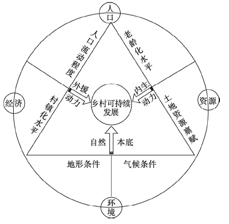
图1
乡村地域系统主导要素与作用
Fig. 1
Leading factors and functions of rural regional system
3.2 乡村地域系统主导要素的地域分异规律
表3 各主成分得分系数
Tab. 3
| 编号 | Z1 | Z2 | Z3 | Z4 | Z5 | Z6 |
|---|---|---|---|---|---|---|
| X1 | 0.217 | -0.022 | 0.170 | 0.022 | 0.072 | -0.100 |
| X2 | 0.333 | -0.010 | -0.093 | 0.001 | 0.053 | 0.066 |
| X3 | 0.308 | -0.003 | -0.035 | -0.006 | 0.073 | -0.050 |
| X4 | 0.031 | 0.004 | 0.481 | 0.012 | -0.066 | 0.143 |
| X5 | -0.125 | -0.003 | 0.517 | 0.008 | -0.049 | 0.103 |
| X6 | 0.321 | -0.077 | -0.055 | -0.013 | -0.253 | 0.143 |
| X7 | 0.006 | -0.050 | -0.014 | 0.573 | -0.014 | 0.004 |
| X8 | -0.064 | 0.515 | 0.043 | -0.001 | -0.493 | 0.103 |
| X9 | 0.036 | 0.012 | 0.129 | 0.001 | -0.148 | 1.036 |
| X10 | -0.009 | -0.193 | -0.038 | -0.014 | 0.986 | -0.093 |
| X11 | -0.047 | 0.341 | -0.016 | -0.006 | 0.028 | -0.054 |
| X12 | -0.010 | 0.039 | 0.046 | 0.572 | -0.018 | -0.003 |
| X13 | 0.021 | 0.318 | -0.036 | -0.008 | 0.030 | -0.015 |
图2
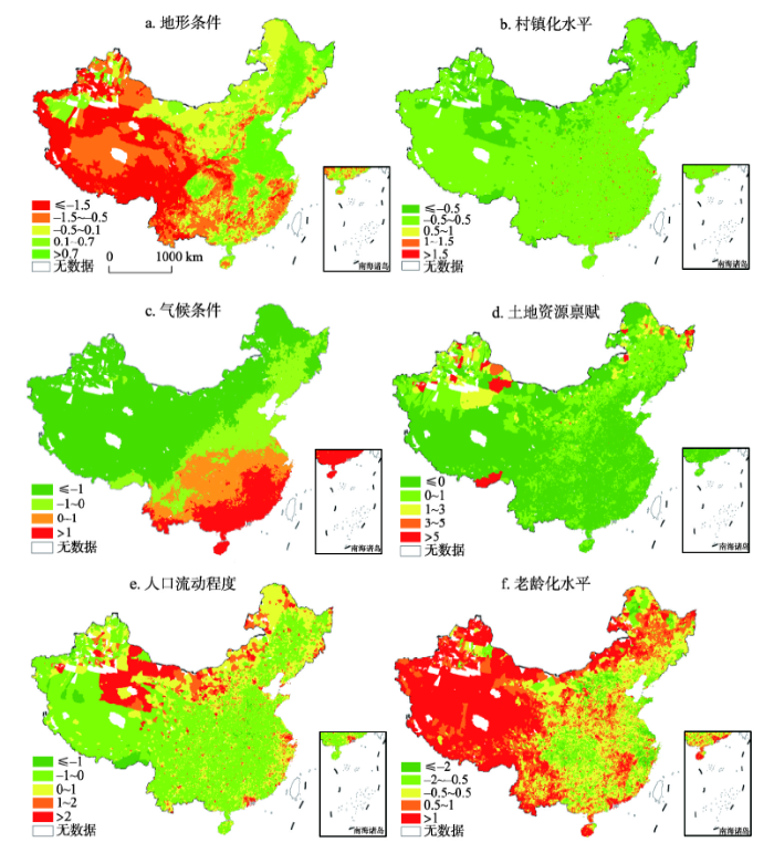
图2
中国乡村地域系统主导要素的空间格局(主成分得分)
注:该图基于国家测绘地理信息局标准地图服务网站审图号为GS(2016)2893号的标准地图制作,底图无修改。
Fig. 2
Spatial patterns of leading factors of rural regional systems in China (Principale component values)
从地理环境基础来看,地势三大阶梯和三大自然区(东部季风区、西北干旱半干旱区、青藏高寒区)构成了中国自然地理格局的基本骨架[35]。自西向东地势逐渐降低,呈阶梯状分布(图2a);从沿海到内陆降水逐渐减少,从低纬到高纬积温逐渐升高(图2c)。已有研究对中国自然地理格局及其分异特征已做了深入分析,在此不再赘述。从村镇化水平来看,全国村镇化水平呈“点面结合、零星分布”的空间格局,村镇化水平较高的乡村主要分布在北京、上海、广州、成都、重庆、武汉、西安、郑州等大城市郊区,而西南部、西北部、东北等地区村镇化水平相对较低(图2b)。从水土资源禀赋状况来看,东北地区、新疆地区以及藏南河谷少数乡村的人均耕地面积较多,但受地形和气候影响,仅东北地区乡村土地资源的粮食生产潜力较高,其他地区人多地少、农业生产适宜性差等矛盾较为突出(图2d)。从人口流动情况来看,受城镇化和工业化辐射带动作用影响,长三角、珠三角、环渤海等东部经济发达地区以及中西部省会城市周边区域是乡村人口的流入区域,呈组团式分布,而西北地区、东北山区大量农村人口向附近的工业城市以及东部经济发达地区转移,是乡村人口的外流区,集中连片呈带状分布(图2e)。从农村老龄化水平来看,东北山区、西北干旱区、青藏高原、云贵高原以及西南山地丘陵区由于大量中青年劳动力外出务工,导致农村老龄化水平较高,乡村发展内生发展动力不足,农村社会主体老弱化问题突出(图2f)。
3.3 中国乡村地域系统区划
按照前文分区方法,通过“要素聚类—发展水平判断—主导要素识别—区划范围确定”的步骤划定乡村地域系统一级区。① 对6个主导要素进行聚类分析,按类间距离最小的原则确定最优聚类数,即区划类型数,得到每个乡镇的聚类结果,最优聚类数为12。② 以村镇化水平表征乡村经济发展水平,计算同一类型中所有乡镇村镇化水平的平均值(AZ2),AZ2 < -0.5、-0.5 ≤ AZ2 < 0.5、0.5 ≤ AZ2 < 1、1 ≤ AZ2 < 1.5、AZ2 ≥ 1.5分别表示乡村经济发展水平低、较低、中等、较高、高,判断各大地域系统类型区的乡村发展水平。③ 将得分最低的主导要素识别为乡村经济发展处于中等水平及以下地域系统类型区的约束要素,得分最高的主导要素识别为乡村经济发展处于较高水平和高水平地域系统类型区的驱动要素。④ 把聚类分析的结果导入ArcGIS进行可视化表达,将数据缺失的部分乡镇与其相邻地区识别为同一地域系统类型,结合相关区划成果对少数分散分布的乡镇进行边界调整,得到乡村地域系统一级区。在一级区划的基础上,将6个主导要素进行空间叠加,对一级区内部的乡镇进行聚类分析,其余步骤与一级区划一样,得到乡村地域系统二级区,最终形成中国乡村地域系统区划方案(图3)。
图3
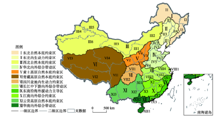
图3
中国乡村地域系统区划方案
注:该图基于国家测绘地理信息局标准地图服务网站下载的审图号为GS(2016)2893号的标准地图制作,底图无修改。
Fig. 3
Regionalization scheme of rural regional systems in China
中国乡村地域系统区划方案包括12个一级区、43个二级区。一级区包括东北自然本底约束区(Ⅰ)、东北内生动力约束区(Ⅱ)、西北自然本底约束区(Ⅲ)、华北内外综合带动区(Ⅳ)、黄土高原自然本底约束区(Ⅴ)、青藏高原自然本底约束区(Ⅵ)、四川盆地内生动力约束区(Ⅶ)、长江中下游内外综合带动区(Ⅷ)、东南沿海外援动力主导区(Ⅸ)、江南内外综合约束区(Ⅹ)、云贵高原自然本底约束区(Ⅺ)、华南内外综合带动区(Ⅻ)。进一步统计结果表明:中国乡村地域系统类型在中国东部地区、中部地区和边境地区呈现明显的差异性,具体表现为东部沿海地区整体的村镇化水平较高,乡村经济发展由强度相似的外援驱动力和内生动力共同带动;中部地区村镇化程度为中等水平,乡村经济发展过程中的外援驱动力较大,内生动力不足;东北山区、西北干旱区、青藏高原区、西南高山区等地区受自然环境约束,加上地理位置较偏远,乡村经济发展外援动力有限,内生动力不足,整体村镇化水平较低(表4)。
表4 中国乡村地域系统分区统计
Tab. 4
| 名称 | 乡镇数量 (个) | 面积 (104 km2) | 人口密度 (人/km2) | 农田生产潜力 (kg/ha) | 建设用地占比 (%) |
|---|---|---|---|---|---|
| 东北自然本底约束区 | 2853 | 46.48 | 192.21 | 3056.71 | 22.12 |
| 东北内生动力约束区 | 1052 | 65.80 | 35.40 | 2035.65 | 12.39 |
| 东南沿海外援动力主导区 | 2293 | 19.37 | 639.43 | 1162.41 | 18.56 |
| 华北内外综合带动区 | 7089 | 53.15 | 577.99 | 5308.59 | 25.22 |
| 华南内外综合带动区 | 1200 | 17.04 | 326.95 | 1816.18 | 11.90 |
| 黄土高原自然本底约束区 | 3333 | 44.82 | 185.35 | 2473.58 | 11.27 |
| 江南内外综合约束区 | 3455 | 41.35 | 251.44 | 2299.08 | 6.91 |
| 西北自然本底约束区 | 1540 | 225.12 | 15.38 | 1592.53 | 8.12 |
| 青藏高原自然本底约束区 | 1922 | 236.43 | 5.83 | 223.96 | 1.61 |
| 四川盆地内生动力约束区 | 5038 | 37.24 | 306.31 | 3148.72 | 6.83 |
| 云贵高原自然本底约束区 | 4596 | 74.73 | 143.40 | 1118.27 | 2.52 |
| 长江中下游内外综合带动区 | 4793 | 46.16 | 483.19 | 4325.37 | 20.11 |
| 全国 | 39164 | 907.79 | 141.12 | 2914.73 | 13.57 |
注:表中所有统计数据均以现有的乡镇数据为基础,缺失的乡镇数据不包括在内。
3.4 中国乡村振兴分区战略
乡村地域系统区划为科学认知新时期乡村地域分异规律、服务支撑乡村振兴重大战略提供了理论依据和决策支持(表5)。
表5 中国乡村地域系统分区及其乡村振兴策略
Tab. 5
| 一级区 | 二级区 | 乡村振兴主要策略 |
|---|---|---|
| Ⅰ东北自然本底 约束区 | Ⅰ1小兴安岭山区地形约束型较低水平区 | 生态为先、三产融合、分区治理、绿色发展,着力发展特色林产业、现代高效农业与文旅观光业。 |
| Ⅰ2三江平原农业内生主导型中等水平区 | ||
| Ⅰ3长白山地形约束型较低水平区 | ||
| Ⅱ东北内生动力 约束区 | Ⅱ1中部平原外援驱动型较高水平区 | 发挥资源综合优势,创新内生增长机制,引领区域农业现代化、工业园区化、乡村城镇化融合发展。 |
| Ⅱ2北部平原农业内生主导型中等水平区 | ||
| Ⅱ3大兴安岭山前农业内生约束型较低水平区 | ||
| Ⅱ4长白山山前农业内生约束型较低水平区 | ||
| Ⅲ西北自然本底 约束区 | Ⅲ1灌溉农业内生主导型较低水平区 | 合理利用水资源,优化水土配置和乡村产业结构,优先发展生态型现代农业与乡村特色文旅创新产业,围绕水、能源与生态问题,创建陕甘宁蒙经济协作区。 |
| Ⅲ2内蒙古东部农牧业内生约束型较低水平区 | ||
| Ⅲ3内蒙古西部干旱气候约束型低水平区 | ||
| Ⅲ4伊犁河谷干旱气候约束型低水平区 | ||
| Ⅲ5北疆地区干旱气候约束型低水平区 | ||
| Ⅲ6南疆地区干旱气候约束型低水平区 | ||
| Ⅳ华北内外综合 带动区 | Ⅳ1山东半岛农业内生主导型中等水平区 | 村镇建设与城乡融合发展,加快农业信息化、产业化、乡村智慧化和乡村空间重构,创建村镇有机体、田园综合体。 |
| Ⅳ2京津外援驱动型较高水平区 | ||
| Ⅳ3燕山太行山地形约束型较低水平区 | ||
| Ⅳ4豫西农业内生主导型中等水平区 | ||
| Ⅳ5黄淮海平原内外综合驱动型较高水平区 | ||
| Ⅴ黄土高原自然本底 约束区 | Ⅴ1渭河平原内外综合驱动型中等水平区 | 保护水与生态环境、优化人地关系,科学推进生态产业化、产业生态化、乡村社区化,创建黄河流域生态经济特区。 |
| Ⅴ2甘宁山区地形约束型较低水平区 | ||
| Ⅴ3晋西河谷农业内生主导型中等水平区 | ||
| Ⅴ4中部高原地形约束型较低水平区 | ||
| Ⅵ青藏高原自然本底 约束区 | Ⅵ1川西高原地形约束型较低水平区 | 强化生态保护与环境修复,保护“中华水塔”和高原人文景观,健全生态补偿长效机制和生态富民治理体系。 |
| Ⅵ2藏南河谷地形约束型低水平区 | ||
| Ⅵ3藏北高寒气候约束型低水平区 | ||
| Ⅵ4青海资源环境约束型低水平区 | ||
| Ⅶ四川盆地内生动力 约束区 | Ⅶ1大巴山内生约束型较低水平区 | 强化三生结合、城乡融合发展,创建乡村双创和扶贫富民强村新机制新模式。 |
| Ⅶ2成渝外援驱动型较高水平区 | ||
| Ⅷ长江中下游内外综合 带动区 | Ⅷ1长三角城镇化外援驱动型高水平区 | 城乡一体化、产业园区化、乡村智慧化与治理能力现代化,创建高质量综合体发展新模式。 |
| Ⅷ2皖南农业内生主导型中等水平区 | ||
| Ⅷ3湘鄂赣城镇化外援驱动型较高水平区 | ||
| Ⅷ4平原内外综合驱动型较高水平区 | ||
| Ⅸ东南沿海外援动力 主导区 | Ⅸ1浙闽城镇化外援驱动型型较低水平区 | 城乡融合与智慧社区建设,创新中心城镇化、外向特色园区化,创建生态文明制度、现代产业制度。 |
| Ⅸ2粤东沿海劳务输出型中等水平区 | ||
| Ⅸ3珠三角城镇化外援驱动型较高水平区 | ||
| Ⅹ江南内外综合 约束区 | Ⅹ1武夷山农业内生约束型较低水平区 | 强化生态农业与绿色发展,促进工农结合和优势产业品牌化、有机化、市场化。 |
| Ⅹ2湘赣平原外援动力不足型中等水平区 | ||
| Ⅹ3南岭农业内生约束型较低水平区 | ||
| Ⅺ云贵高原自然本底 约束区 | Ⅺ1东部山地丘陵地形约束型较低水平区 | 保护生态环境和自然、人文景观资源,创建特色产业经营体系,繁荣民族文化和文旅康养新经济。 |
| Ⅺ2滇贵资源环境约束型较低水平区 | ||
| Ⅺ3滇西边境地形约束型较低水平区 | ||
| Ⅻ华南内外综合 带动区 | Ⅻ1海南内外综合驱动型较高水平区 | 发展共享经济、创意产业园区,创建国际化农业特区和生态文明示范区。 |
| Ⅻ2两广内外综合驱动型较高水平区 |
(1)东北自然本底约束区:包括大兴安岭北部、小兴安岭、三江平原和长白山地区。受地形地貌约束,区域城镇化、工业化相对滞后,乡村发展主要动力在于推进农业农村现代化。该区与蒙古、俄罗斯、朝鲜三国接壤,东部为三江平原,南部为山地丘陵,区内森林资源丰富,以粮食生产和林区特色农业为主,是全国重要的特色农林产品基地。除三江平原外,大部分地区由于山地地形的限制,农业经营效益低下,开垦荒地造成生态严重破坏;资源型城市衰竭和城乡发展转型面临改制压力,农村劳动力转移受阻,农民增收缓慢且来源不稳定,基础设施建设落后,是东北贫困人口和少数民族人口集聚区[40]。该区应充分发挥水土资源、生态环境优势和边境区位条件,强化资源保护与节约利用,将生态保育、乡村社区化和现代特色农林业相结合,重视山水林田湖草生命共同体建设,强化生态文化与粮食安全功能,促进乡村“三产”融合,实现乡村资源、生态和社会、经济协调与可持续发展。
(2)东北内生动力约束区:包括黑龙江、吉林、辽宁三省的平原与山前丘陵大部分乡镇区域。乡村发展的动力在于现代农业及其产业化,工业化、城镇化具有一定带动作用。该区地形平坦,土壤肥沃,耕地资源丰富,农业规模化与商品化程度较高,是中国重要的粮食主产区。区内矿产资源丰富,工业基础好,也是全国重要的老工业基地。该区面临着资源枯竭、人口流失、土地生态退化等问题。区内人口密度为35人/km2,大量青壮年劳动力流失造成农村老龄化、农业兼业化问题突出,城乡内生发展动力不足。该区应立足雄厚的农业资源基础,有效推进农村土地流转,培育新型农业经营主体,创新现代“场部制”模式,充分发挥粮食生产功能,促进农业现代化和工业园区化、乡村城镇化融合发展。改善乡村基础设施和公共服务环境,推动农村环境综合治理和资源保护,推进现代农业综合体、村镇有机体建设,提升乡村价值与形象,让东北乡村吸引人、留住人,以乡村人才振兴、产业振兴、生态振兴推动东北地区振兴。
(3)西北自然本底约束区:包括内蒙古、新疆及甘肃、宁夏的部分乡镇区域。受内陆干旱气候的影响,区域生态环境脆弱,农业与乡村发展水平较低。该区整体位于西北干旱区,光热条件好但水资源匮乏,以绿洲农业、灌溉农业和畜牧业为主,是中国重要的棉花、特色水果生产基地;煤炭、石油、有色金属等矿产资源丰富,是全国重要的能源基地。长期以来过度开垦、过度放牧以及肆意开采能源矿产造成土地荒漠化、草场退化等环境问题,脆弱的生态环境导致自然灾害多发频发,人地矛盾突出。该区应以生态保育与自然修复、乡村减贫与持续发展为战略抓手,系统开展节水技术的研发与推广、生态环境修复与治理,优先发展节水农业、生态旅游业和电商物流服务业,将资源禀赋、环境优势转化为经济优势,改善乡村交通物流设施条件,加强水利基础设施和乡村社区网络建设,拓宽农业转移就业渠道,加快补齐乡村民生短板。
(4)华北内外综合带动区:包括京津冀、山东、江苏及安徽北部、河南东北部部分乡镇区域。该区农业生产条件优越,工业化、城镇化进程较快,受外援驱动力和内生发展能力的综合作用,乡村发展水平高、实力强。区内地势平坦,耕地资源丰富,水热条件较好,土地粮食生产潜力为5308 kg/hm2,是国家粮食和主要农产品供给区。该区受大城市群发展影响,乡村人口结构、土地利用结构、城乡产业结构的转型和地域功能升级快,多数乡村已进入工农互动、城乡一体的转型发展新阶段。该区应立足资源条件、区位优势,以市场需求为导向,创建田园综合体,促进现代农业产业化、智慧化、生态化,完善农村基础设施建设和公共服务体系,通过新型城镇化和乡村振兴“双轮驱动”,实现城乡融合与乡村发展转型升级,加快农业转移人口市民化和城乡发展一体化。
(5)黄土高原自然本底约束区:包括山西西部、陕西中南部及甘肃、宁夏南部的大部分乡镇区域。该区地形复杂、沟壑纵横,生态环境的本底脆弱、水土流失严重,受地形格局和气候条件的制约,乡村经济发展水平较低。长期以来,由于人口快速增长带来了滥砍滥伐、过度开垦,加剧了乡村人地矛盾。水资源短缺是整个黄土高原农业发展的“瓶颈”因素,还有农村经济基础差、产业结构单一、交通闭塞、能源短缺等问题,致使城镇化水平较低,乡村自我发展能力较弱。该区应以生态保育和基本农田建设为基础,推广节水灌溉技术和造林实用技术,依靠科技进步解决水资源缺乏、环境恶化、经济停滞的发展难题。科学实施退耕还林、生态环境保护、治沟造地土地整治重大工程,推广沟道—边坡土地整治与现代农业技术[41],持续改善农业生产条件。着力发展特色林果业、立体农业与文旅康养产业,调整现代农业与城乡经济结构,走生态产业化、高质量绿色发展之路。
(6)青藏高原自然本底约束区:主要包括西藏、青海、四川西部地区。该区以青藏高原为主体,平均海拔在4000 m左右,气候干旱寒冷,以高原农牧业为主,土地利用效率和粮食生产潜力较低。地理环境较为封闭,交通、电讯等基础设施和公共服务设施建设落后,工业化、城镇化发展缓慢,乡村综合发展水平较低。青藏高原是中国大江大河的主要发源地,孕育着“中华水塔”,具有国家生态安全屏障的重要地位。该区应以生态保护和环境修复为主要目标,探索建立生态补偿长效制度,创新畜牧业“减压增效”与农旅融合机制,发展具有高原特色的现代农牧业、生态旅游业,走生态产业化、治理现代化发展道路,切实提高农牧民收入和城乡公共服务水平,实现乡村经济社会和生态环境的协调与可持续发展。
(7)四川盆地内生动力约束区:包括四川东部、重庆西部以及大巴山区部分乡镇区域。受成渝城市群的辐射带动作用较强,但乡村发展的内生动力不足。该区以低山丘陵为主,自然资源丰富,农业地域类型多样,土地粮食生产潜力大,乡村人口密度高,乡村老龄化问题突出。近年来,随着工业化、城镇化进程的加快,乡村生产要素快速非农化、农村主体老弱化、村庄用地空废化等“乡村病”问题显现,乡村发展进入了转型升级关键期[4]。该区应以发展都市型田园综合体为重点,着力根治“乡村病”,积极引导农村土地流转和空心村综合整治,培育农业生产合作社、种养大户、共享农场等新型经营主体,完善农业现代化生产经营体系、市场服务体系,改善农村人居环境和促进人地协调共生,持续提升乡村自我发展能力、活力与竞争力。
(8)长江中下游内外综合带动区:包括上海、江苏、安徽、浙江、江西、湖北、湖南的大部分乡镇区域。受外援动力和内生动力的双重驱动,工业化和城镇化进程较快,乡村发展水平较高。该区地势平坦开阔,气候温暖湿润,耕地资源丰富,土地粮食生产力水平高,是中国重要的农产品主产区。但是,工业化、城镇化带来的污废物及农药、化肥的大量使用造成了乡村水土环境恶化,河流、湖泊、农田污染事件频发,制约了农业与乡村可持续发展。该区应以推进长江经济带、长三角一体化发展战略为契机,坚持以中小城市和小城镇为依托,以发展产业园区和产业生态化为重点,优化山水林田湖人地耦合格局与村镇空间组织体系,提高土地利用效率与效益,重视加强乡村环境综合治理,推进美丽宜居乡村建设,持续改善人居环境质量,打造产业兴旺、生态宜居、乡村文明的乡村振兴区域样板。
(9)东南沿海外援动力主导区:包括浙江、福建沿海以及广东东南部的大部分乡镇区域。依靠沿海区位优势,受区域发展政策的外援驱动较强,乡村综合发展水平高。该区地形以平原、丘陵为主,光、热、水资源丰富,海岸线漫长,是中国重要的水产品养殖区和经济作物种植区。对外开放程度高,市场化进程较快,促进了乡村地域内核系统与外援系统要素的有序流动。区内人口密度最高,耕地资源较少,2015年人均耕地面积仅有1.19亩,人地矛盾较为突出。因此,该区应立足于区位优势和现代特色农业基础,加快构建现代农业产业体系、生态体系和经营体系,积极吸引城市资本及外商投资,大力发展农产品深加工、城郊型农业和休闲观光业,推动乡村区域提质增效,实现乡村经济转型升级,走绿水青山、产业生态化之路。
(10)江南内外综合约束区:包括江西、湖南、福建西部及两广北部的部分乡镇区域。受地形和区位因素的制约,区内农业经营方式较落后,工业化、城镇化的外援驱动力较弱,乡村发展处于中等水平。该区以山地丘陵为主,水热条件优越,农业类型多样,是中国重要的粮食主产区和淡水产区。区域城市经济发展水平较高,但城乡发展差距较大,工业化、城镇化对乡村地域的辐射带动作用有限。不合理的资源开发利用加剧了山区水土流失、生态退化,平原农区的围湖造田导致湖泊面积缩小、生物多样性减少。该区应充分利用比较发达的工农业基础,重点发展外向型农业和乡村特色经济,改善乡村生态环境,建设绿色、高效、优质的现代农产品生产基地,加快城乡发展一体化建设,实现城乡融合与乡村振兴的共赢目标。
(11)云贵高原自然本底约束区:包括云南、贵州、广西西北部以及湘、鄂、渝、黔四省交界地区的部分乡镇区域。受喀斯特地貌的约束,乡村发展总体水平较低。该区以云贵高原为主体,地势起伏大,耕地破碎且土层稀薄,是全国喀斯特地貌最典型、分布最广的地区,石漠化问题突出,农业生产条件较差。区内工业化、城镇化水平较低,基础设施建设落后,城乡联系薄弱,农村居民就业难、收入低,是全国贫困人口集中分布的连片特困地区,人地矛盾十分尖锐。该区应坚持经济发展与生态环境保护相结合,积极推进石漠化地区生态综合治理,加强农村教育、医疗、网络等基础设施和公共服务设施建设,合理利用山区丰富的旅游资源、生物资源,发展立体高效农业、农副产品和林产品加工业、乡村旅游业,以精准扶贫助力乡村振兴,整体提升乡村地域功能、生态文化价值。
(12)华南内外综合带动区:包括海南、广东和广西南部的部分乡镇区域。受外援动力和内生动力的双重驱动,城镇化带动能力较强,乡村发展水平较高。该区以低山丘陵为主,水热资源丰富,是中国热带农作物的核心产区。自然风光优美,现代旅游业发达,对外开放程度高,区域经济联动和城乡联系较为密切。该区应立足于临海的区位条件和资源优势,加快热带作物专业化生产基地和服务体系建设,面向国内外市场,注重城乡融合与一体化发展,充分发挥开放经济区、自贸区优势,积极创建现代绿色农业、共享农庄、乡村生态旅游与康养产业体系,推动农业生产市场化、集约化、专业化,率先实现农业农村现代化、区域协作国际化。
4 结论与讨论
本文在深入解析人地系统科学、乡村地域系统和城乡有机体相关理论基础上,首次以全国乡镇为基本单元,构建了乡村地域系统可持续发展评价指标体系,运用主成分分析法定量识别了制约乡村地域系统可持续发展的主导因子。通过聚类分析、空间叠加和定性定量相结合的综合方法,研制了中国乡村地域系统区划方案,探究了中国乡村地域系统类型分异特征及其乡村振兴途径。
(1)乡村地域系统是一个由人文、经济、资源与环境相互联系、相互作用下构成的、具有一定结构、功能和区际联系的乡村空间体系。影响和制约乡村地域系统可持续发展的主导要素包括地理环境、村镇化水平、气候条件、土地资源禀赋、人口外流程度和老龄化水平等。中国乡村地域系统划分为12个一级区、43个二级区。一级区采用“地理区位+主导要素驱动力/约束力”的方法命名,分别为东北自然本底约束区、东北内生动力约束区、西北自然本底约束区、华北内外综合带动区、黄土高原自然本底约束区、青藏高原自然本底约束区、四川盆地内生动力约束区、长江中下游内外综合带动区、东南沿海外援动力主导区、江南内外综合约束区、云贵高原自然本底约束区、华南内外综合带动区。二级区采用“地域范围+主导要素驱动力/约束力+乡村经济发展水平”的三段法命名,深刻反映了乡村地域系统类型的复杂性。
(2)不同乡村地域系统的发展现状、动力来源和发展方向存在明显差异。乡村地域系统区划为科学认知新时期乡村地域分异规律、服务支撑乡村振兴战略提供了理论依据和决策支持。中国乡村振兴理应坚持因地制宜、分区推进、分类施策原则,遵循乡村地域系统演化及其分异规律,按照乡村发展问题导向和乡村振兴目标指向,系统探究不同类型区的乡村系统转型与振兴地域模式、科学路径。新时期亟需重视培育乡村振兴新主体,引导扶持“三乡人”(返乡农民工、下乡市民、回乡大学生),加快健全“三乡师”(乡村规划师、建筑师、工程师)。面向国际科学前沿和国家战略需求,地理学者理应立足专业综合优势、发挥科技支撑作用,读万卷书、行万里路、谋万民福。抢抓乡村振兴战略新机遇,推进现代地理研究新突破,科学揭示不同类型地域乡村社会结构演化与乡村空间形态变化规律,在跨区域尺度,深入探究不同地域系统的城乡融合、人地耦合、功能契合的内在机理和高质量发展的新动力源,为实现城乡要素有效配置、乡村空间有机重构、乡村振兴有序推进提供强有力的科技支撑。
(3)本文基于乡镇尺度对中国乡村地域系统的主导要素与地域类型进行了定量研究,与县域尺度相比[38],乡镇尺度的乡村地域系统类型研究具有明显的优势和特点:① 以乡镇为基本单元,可以剔除县城所在的街道、城关镇等城镇地域,避免县域城镇地域对乡村地域系统区划结果的影响,准确地刻画了乡村地域系统范围。② 乡镇尺度的空间数据承载地理信息的精度更高,更有助于揭示乡村地域系统构成要素在空间分布上的差异性和规律性。③ 地理数据具有地理位置、距离等隐含的空间信息,利用K-means、SOM模型等数学统计方法进行地理数据聚类分析时未考虑空间维度,本文运用“要素聚类+空间叠加”的区划方法,弥补了传统数学方法的不足。然而,受数据可获取性的影响,本研究构建的乡村地域系统可持续发展指标体系,尚未考虑制度、文化、组织、土地利用等人文过程要素的综合作用。进一步应用大数据技术和结合典型案例区,从微观尺度探究不同类型乡村地域系统演化的过程与机制,揭示“人地圈”机理与人地系统科学原理,深入研究城乡融合空间格局与乡村振兴地域类型,探明不同类型区乡村振兴途径与地域模式,乃是新时期地理学服务乡村振兴和区域可持续发展国家战略的重大前沿课题。
参考文献
Balance urban and rural development must change the urban-oriented development strategy
统筹城乡发展必须转变城市偏向发展战略
Theoretical thinking of rural restructuring
DOI:10.18306/dlkxjz.2018.05.002
URL
[本文引用: 1]

With its focus on the increasingly complicated human-environment relationship under the background of rapid urbanization, rural restructuring study has become an important frontier research area of geography. Rural restructuring is a process of reshaping the socioeconomic forms and spatial patterns in rural areas in respond to the changes of factors both internal and external of the system, by optimally allocating and efficiently managing the material and non-material elements of rural development. It aims at ultimately optimizing the structures and improving the functions within rural territorial systems as well as realizing the structural coordination and functional complementation between urban and rural territorial system. Based on the perspective of "elements-structure-function" of rural territorial system, this article first elaborated the concept of rural restructuring from the aspects of behavioral mainstream, value system, and targets. Then, a framework of rural restructuring mechanism was analyzed, which consisted of inducing mechanism, supporting mechanism, constraining/promoting mechanism, guiding mechanism, and driving mechanism. Furthermore, in view of the guiding role of governments in optimal allocation of critical resources and rural restructuring, this article argued that it is necessary to restructure the contours of state intervention in rural societies and economies. Finally, the research contents of rural restructuring in the future were prospected.
乡村重构的理论认知
DOI:10.18306/dlkxjz.2018.05.002
URL
[本文引用: 1]
With its focus on the increasingly complicated human-environment relationship under the background of rapid urbanization, rural restructuring study has become an important frontier research area of geography. Rural restructuring is a process of reshaping the socioeconomic forms and spatial patterns in rural areas in respond to the changes of factors both internal and external of the system, by optimally allocating and efficiently managing the material and non-material elements of rural development. It aims at ultimately optimizing the structures and improving the functions within rural territorial systems as well as realizing the structural coordination and functional complementation between urban and rural territorial system. Based on the perspective of "elements-structure-function" of rural territorial system, this article first elaborated the concept of rural restructuring from the aspects of behavioral mainstream, value system, and targets. Then, a framework of rural restructuring mechanism was analyzed, which consisted of inducing mechanism, supporting mechanism, constraining/promoting mechanism, guiding mechanism, and driving mechanism. Furthermore, in view of the guiding role of governments in optimal allocation of critical resources and rural restructuring, this article argued that it is necessary to restructure the contours of state intervention in rural societies and economies. Finally, the research contents of rural restructuring in the future were prospected.
Research on the urban-rural integration and rural revitalization in the new era in China
DOI:10.11821/dlxb201804004
URL
[本文引用: 8]
Cities and villages are components of a specific organism. Only the sustainable development of two parts can support the prosperous development as a whole. According to the theory of man-earth areal system, urban-rural integrated system and rural regional system are the theoretical bases for entirely recognizing and understanding urban-rural relationship. To handle the increasingly severe problems of "rural disease" in rapid urbanization, accelerating rural revitalization in an all-round way is not only a major strategic plan for promoting the urban-rural integration and rural sustainable development, but also a necessary requirement for solving the issues related to agriculture, rural areas, and rural people in the new era and securing a decisive victory in building a moderately prosperous society in all respects. This study explores the basic theories of urban-rural integration and rural revitalization and analyzes the main problems and causes of rural development in the new era, proposing problem-oriented scientific approaches and frontier research fields of urban-rural integration and rural revitalization in China. Results show that the objects of urban-rural integration and rural revitalization is a regional multi-body system, which mainly includes urban-rural integration, rural complex, village-town organism, and housing-industry symbiosis. Rural revitalization focuses on promoting the reconstruction of urban-rural integration system and constructs a multi-level goal system including urban-rural infrastructure networks, zones of rural development, fields of village-town space and poles of rural revitalization. Currently, the rural development is facing the five problems: high-speed non-agricultural transformation of agriculture production factors, over-fast aging and weakening of rural subjects, increasingly hollowing and abandoning of rural construction land, severe fouling of rural soil and water environment and deep pauperization of rural poverty-stricken areas. The countryside is an important basis for the socioeconomic development in China, and the strategies of urban-rural integration and rural revitalization are complementary. The rural revitalization focuses on establishing the institutional mechanism for integrated urban-rural development and constructs the comprehensive development system of rural regional system, which includes transformation, reconstruction and innovation in accordance with the requirements of thriving businesses, pleasant living environments, social etiquette and civility, effective governance, and prosperity. Geographical research on rural revitalization should focus on the complexity and dynamics of rural regional system and explore new schemes, models and scientific approaches for the construction of villages and towns, which are guided by radical cure of "rural disease", implement the strategy of rural revitalization polarization, construct the evaluation index system and planning system of rural revitalization, thus providing advanced theoretical references for realizing the revitalization of China's rural areas in the new era.
中国新时代城乡融合与乡村振兴
DOI:10.11821/dlxb201804004
URL
[本文引用: 8]
Cities and villages are components of a specific organism. Only the sustainable development of two parts can support the prosperous development as a whole. According to the theory of man-earth areal system, urban-rural integrated system and rural regional system are the theoretical bases for entirely recognizing and understanding urban-rural relationship. To handle the increasingly severe problems of "rural disease" in rapid urbanization, accelerating rural revitalization in an all-round way is not only a major strategic plan for promoting the urban-rural integration and rural sustainable development, but also a necessary requirement for solving the issues related to agriculture, rural areas, and rural people in the new era and securing a decisive victory in building a moderately prosperous society in all respects. This study explores the basic theories of urban-rural integration and rural revitalization and analyzes the main problems and causes of rural development in the new era, proposing problem-oriented scientific approaches and frontier research fields of urban-rural integration and rural revitalization in China. Results show that the objects of urban-rural integration and rural revitalization is a regional multi-body system, which mainly includes urban-rural integration, rural complex, village-town organism, and housing-industry symbiosis. Rural revitalization focuses on promoting the reconstruction of urban-rural integration system and constructs a multi-level goal system including urban-rural infrastructure networks, zones of rural development, fields of village-town space and poles of rural revitalization. Currently, the rural development is facing the five problems: high-speed non-agricultural transformation of agriculture production factors, over-fast aging and weakening of rural subjects, increasingly hollowing and abandoning of rural construction land, severe fouling of rural soil and water environment and deep pauperization of rural poverty-stricken areas. The countryside is an important basis for the socioeconomic development in China, and the strategies of urban-rural integration and rural revitalization are complementary. The rural revitalization focuses on establishing the institutional mechanism for integrated urban-rural development and constructs the comprehensive development system of rural regional system, which includes transformation, reconstruction and innovation in accordance with the requirements of thriving businesses, pleasant living environments, social etiquette and civility, effective governance, and prosperity. Geographical research on rural revitalization should focus on the complexity and dynamics of rural regional system and explore new schemes, models and scientific approaches for the construction of villages and towns, which are guided by radical cure of "rural disease", implement the strategy of rural revitalization polarization, construct the evaluation index system and planning system of rural revitalization, thus providing advanced theoretical references for realizing the revitalization of China's rural areas in the new era.
The agricultural region of Jiangsu Province
DOI:10.11821/xb193401004
URL
[本文引用: 1]
The Province Kiangsu is one of the most prosperous agricultural regions of China. It yield 8.5% of rice, 12.5% of wheat, 20% of cotton, 16% of cocoon produced in the whole country.The province may be divided into four agricultural regions according to their predominate products:1. The northern region where wheat, kaoliang, maize, and millet are prod-uced.2. The central rice region,3. The southern rice and sericulture region, and4. The coastal cotton region.
江苏省之农产区域
DOI:10.11821/xb193401004
URL
[本文引用: 1]
The Province Kiangsu is one of the most prosperous agricultural regions of China. It yield 8.5% of rice, 12.5% of wheat, 20% of cotton, 16% of cocoon produced in the whole country.The province may be divided into four agricultural regions according to their predominate products:1. The northern region where wheat, kaoliang, maize, and millet are prod-uced.2. The central rice region,3. The southern rice and sericulture region, and4. The coastal cotton region.
Agricultural regions of China
DOI:10.11821/xb193601001
URL
[本文引用: 2]
Various attempts have been made to divide China into regions of agricultural significance. Both the divisions of Nyhus and Cressey are not very satisfatory. According to my recent study, China may be divided into nine greater agricultural regions which are quite similar to the climatic regions of Co-ching Chu.
中国之农业区域
DOI:10.11821/xb193601001
URL
[本文引用: 2]
Various attempts have been made to divide China into regions of agricultural significance. Both the divisions of Nyhus and Cressey are not very satisfatory. According to my recent study, China may be divided into nine greater agricultural regions which are quite similar to the climatic regions of Co-ching Chu.
Modern agricultural geography and land use innovation research
现代农业地理与土地利用创新研究: 贺吴传钧先生90华诞
Agricultural regionalization in Wuxi, Jiangsu Province
江苏省苏锡地区农业区划
Agricultural regionalization in Huaiyin, Jiangsu Province
江苏省淮阴专区农业区划
Fundamental problems on the division of agricultural regions of China
我国农业区划基本问题的探讨
Regional differentiation and comprehensive regionalization scheme of modern agriculture in China
DOI:10.11821/dlxb201802001
URL
[本文引用: 5]
Agriculture consolidates the process of natural reproduction and economic reproduction. Spatial pattern of agricultural region is comprehensively influenced by factors such as natural geography, economic and social development and advances in technology. Along with the changes of these influencing factors over a long period, agricultural pattern and agricultural function present regional differentiation and spatio-temporal evolution. This lays a scientific foundation for comprehensive agricultural regionalization. China is currently experiencing a new period of coordinated development of industrialization, urbanization, informatization and agricultural modernization. This paper firstly investigates spatio-temporal changes and dynamic characteristics of modern agriculture development conditions in China. Then, it puts forward the coupling measure index system of agricultural natural factors and regional function, zoning principles and scientific method of modern agricultural regionalization under the new development background. Using cluster analysis and qualitative analysis, it carries out a comprehensive research and puts forward China's modern agriculture regionalization scheme in the new era, which divides China into 15 agricultural first-grade regions and 53 agricultural sub-regions. After doing a comparative analysis with the new scheme and the previous one, which was published in 1981, the paper makes a systematic interpretation on current producing situation, regional function, spatial pattern changes and agricultural development trend of each agricultural region and the whole country at last. The results of this research provide scientific basis for strategic structural adjustment and development of modern agriculture in each region. At the theoretical level, this paper provides a research reference for the development of modern agriculture and rural geography. At the application level, it promotes integrated geography research to serve the rural revitalization and national development strategic needs in the transition period in China. The regional agriculture is a natural, economic and technological complex system, with the characteristics of complexity, dynamics and high risk. As such, based on the congnition of spatial differentiation of modern agriculture development patterns, it is necessary to deeply analyze the regional differentiation of agricultural endogenous power, agriculture and rural territorial types, to improve observational research of agricultural geographical engineering and technology, and the economic, ecological, climatic integrated effects of regional agriculture transformation, to summarize systematically regional agricultural models and regional transformation patterns, to explore the early warning mechanism of modern agricultural complex system, and to study continuously the theories and strategic decision-making for promoting agricultural modernization and rural revitalization.
中国农业地域分异与现代农业区划方案
DOI:10.11821/dlxb201802001
URL
[本文引用: 5]
Agriculture consolidates the process of natural reproduction and economic reproduction. Spatial pattern of agricultural region is comprehensively influenced by factors such as natural geography, economic and social development and advances in technology. Along with the changes of these influencing factors over a long period, agricultural pattern and agricultural function present regional differentiation and spatio-temporal evolution. This lays a scientific foundation for comprehensive agricultural regionalization. China is currently experiencing a new period of coordinated development of industrialization, urbanization, informatization and agricultural modernization. This paper firstly investigates spatio-temporal changes and dynamic characteristics of modern agriculture development conditions in China. Then, it puts forward the coupling measure index system of agricultural natural factors and regional function, zoning principles and scientific method of modern agricultural regionalization under the new development background. Using cluster analysis and qualitative analysis, it carries out a comprehensive research and puts forward China's modern agriculture regionalization scheme in the new era, which divides China into 15 agricultural first-grade regions and 53 agricultural sub-regions. After doing a comparative analysis with the new scheme and the previous one, which was published in 1981, the paper makes a systematic interpretation on current producing situation, regional function, spatial pattern changes and agricultural development trend of each agricultural region and the whole country at last. The results of this research provide scientific basis for strategic structural adjustment and development of modern agriculture in each region. At the theoretical level, this paper provides a research reference for the development of modern agriculture and rural geography. At the application level, it promotes integrated geography research to serve the rural revitalization and national development strategic needs in the transition period in China. The regional agriculture is a natural, economic and technological complex system, with the characteristics of complexity, dynamics and high risk. As such, based on the congnition of spatial differentiation of modern agriculture development patterns, it is necessary to deeply analyze the regional differentiation of agricultural endogenous power, agriculture and rural territorial types, to improve observational research of agricultural geographical engineering and technology, and the economic, ecological, climatic integrated effects of regional agriculture transformation, to summarize systematically regional agricultural models and regional transformation patterns, to explore the early warning mechanism of modern agricultural complex system, and to study continuously the theories and strategic decision-making for promoting agricultural modernization and rural revitalization.
Study on the pattern and types of rural development in the Huang-Huai-Hai region
黄淮海地区乡村发展格局与类型
Rural transformation development and new countryside construction in eastern coastal area of China
DOI:10.11821/xb200706001
URL
[本文引用: 1]
With the implementation of reform and opening up policies, rapid industrialization and urbanization in the eastern coastal area of China has not only promoted the development of regional economy, enhanced the international competitiveness, but also influenced the vast rural area deeply, bringing great changes to the rural industrial structure, employment structure and agricultural production pattern, and the development of the coastal rural area has come into a new period of transformation and upgrade. The proportion of the primary industry decreased from 23.3% to 7.9% and that of the tertiary industry increased from 19.8% to 40.5%, while the proportion of agricultural labor force decreased from 90.8% to 47.9% during 1978-2005. Analysis shows that proportions of both production value of coastal agriculture in GDP and agricultural labor force in rural labors will continue to decrease to 8.0% and 44.5% by 2010 and to 6.0% and 32.2% by 2020. From 1990 to 2005, the average elasticity coefficient of cultivated land and labor force in the eastern coastal area came to 1.84, which means that the transfer of agricultural labor force is faster than the decrease of cultivated land and the labor productivity is increasing steadily. At the corresponding period, rural population decreased from 306 million to 219 million while rural construction land use per capita increased, indicating that the transfer of rural population failed to be linked to the decrease of rural residential land. The new countryside construction in the eastern coastal area must obey the rules of rural transformation and development, lay stress on scientific plan and regionalization, promote rural productivity and foster interactive and harmonious development between city and countryside by optimizing urban and rural land use and developing modern agriculture and rural characteristic economy.
中国东部沿海地区乡村转型发展与新农村建设
DOI:10.11821/xb200706001
URL
[本文引用: 1]
With the implementation of reform and opening up policies, rapid industrialization and urbanization in the eastern coastal area of China has not only promoted the development of regional economy, enhanced the international competitiveness, but also influenced the vast rural area deeply, bringing great changes to the rural industrial structure, employment structure and agricultural production pattern, and the development of the coastal rural area has come into a new period of transformation and upgrade. The proportion of the primary industry decreased from 23.3% to 7.9% and that of the tertiary industry increased from 19.8% to 40.5%, while the proportion of agricultural labor force decreased from 90.8% to 47.9% during 1978-2005. Analysis shows that proportions of both production value of coastal agriculture in GDP and agricultural labor force in rural labors will continue to decrease to 8.0% and 44.5% by 2010 and to 6.0% and 32.2% by 2020. From 1990 to 2005, the average elasticity coefficient of cultivated land and labor force in the eastern coastal area came to 1.84, which means that the transfer of agricultural labor force is faster than the decrease of cultivated land and the labor productivity is increasing steadily. At the corresponding period, rural population decreased from 306 million to 219 million while rural construction land use per capita increased, indicating that the transfer of rural population failed to be linked to the decrease of rural residential land. The new countryside construction in the eastern coastal area must obey the rules of rural transformation and development, lay stress on scientific plan and regionalization, promote rural productivity and foster interactive and harmonious development between city and countryside by optimizing urban and rural land use and developing modern agriculture and rural characteristic economy.
Research progress and prospect of rural transformation and reconstruction in China: Paradigms and main content
DOI:10.18306/dlkxjz.2015.08.009
URL
[本文引用: 1]
Rural transformation is a leading human process accompanying urban-rural development and the transformation of economic development mode, under the background of rapid urbanization in the past few decades in China. In the study of rural transformation process, spatial reconstruction mechanism and optimal rural spatial reconstruction are of great significant. Using the theory of human-nature relationship in the territorial system, the process of rural transformation and interaction mechanism between this process and land use transformation should be analyzed in future studies to examine the mechanism of rural spatial reconstruction and the pattern of optimal spatial reorganization that affect the process of rural transformation. The integration of remote sensing and GIS and sampling survey and modeling methods should be used to: (1) analyze the process and dynamic patterns of rural transformation and its geographical types; (2) explore the collaborative mechanism between rural transformation and land use transformation; (3) establish models for optimal spatial reorganization that affects rural transformation; (4) identify typical patterns of rural transformation and land use allocation that affect rural spatial reconstruction indifferent functional types; and (5) systematically analyze the mechanism of different rural development patterns and the main regional geographical features. Combined with empirical studies, this research compares and analyzes typical development patterns in terms of the evolution process and interaction mechanism among various factors, to explore geographical patterns and methods for rural spatial reconstruction.
中国乡村转型重构研究进展与展望: 逻辑主线与内容框架
DOI:10.18306/dlkxjz.2015.08.009
URL
[本文引用: 1]
Rural transformation is a leading human process accompanying urban-rural development and the transformation of economic development mode, under the background of rapid urbanization in the past few decades in China. In the study of rural transformation process, spatial reconstruction mechanism and optimal rural spatial reconstruction are of great significant. Using the theory of human-nature relationship in the territorial system, the process of rural transformation and interaction mechanism between this process and land use transformation should be analyzed in future studies to examine the mechanism of rural spatial reconstruction and the pattern of optimal spatial reorganization that affect the process of rural transformation. The integration of remote sensing and GIS and sampling survey and modeling methods should be used to: (1) analyze the process and dynamic patterns of rural transformation and its geographical types; (2) explore the collaborative mechanism between rural transformation and land use transformation; (3) establish models for optimal spatial reorganization that affects rural transformation; (4) identify typical patterns of rural transformation and land use allocation that affect rural spatial reconstruction indifferent functional types; and (5) systematically analyze the mechanism of different rural development patterns and the main regional geographical features. Combined with empirical studies, this research compares and analyzes typical development patterns in terms of the evolution process and interaction mechanism among various factors, to explore geographical patterns and methods for rural spatial reconstruction.
Study on the characteristics and territorial types of rural transformation development: The case of "Southern Jiangsu-Northern Shaanxi" transect
乡村转型发展特征评价及地域类型划分: 以“苏南—陕北”样带为例
Assessment of rural development types and their rurality in eastern coastal China
DOI:10.11821/xb200904005
URL
[本文引用: 1]
Currently, both rural development and urban development in China are experiencing a transition period. the transformation of a traditional agricultural society into a modern industrial and urban society, and the economy is changing from a traditional planned economy to a modern market system. As a result, regional development factors reintegration and followed industrial restructuring have changed the rural areas in eastern coastal China deeply. Different rural development types were shaped basing on a carrier, which is composed of different industries. Accordingly, this paper defines four rural development types, i.e. agriculture-dominated rural development type, industry-dominated rural development type, balanced rural development type, and rural development type focusing on business, tourism and providing services, and classifies the rural development types in eastern coastal China. Then, an indicator system was established to assess the rurality index (RI) of different rural development types in eastern coastal China. The results showed: (1) Relying on the advantages of location and national lean policies, 57.6% of the total territory of eastern coastal China belongs to balanced rural development type, and 18.64%, 11.99% and 11.75% of the total area is shared by agriculture-dominated rural development type, industry-dominated rural development type, and rural development type focusing on business, tourism and providing services, respectively; (2) 59.1% of the agriculture-dominated rural development type shows a strong rurality (RI > 0.5); (3) In the industry-dominated rural development type, the area with a weak rurality (RI < 0.4) and a moderate rurality (0.4 < RI < 0.5) takes up 33.4% and 42.8%, respectively; (4) In the rural development type focusing on business, tourism and providing services, the area with weak, strong and moderate rurality shares 42.7%, 27.3% and 30.0% of the total, respectively; (5) Almost half (45.8%) of the balanced rural development type with a moderate rurality, 17.2% of this type with a weak rurality, and 37% with a strong rurality. In some cases, the big difference of rurality index value among the same development types is due to the development of multi-functionality of current countryside and place-based rural development mode under globalization and socio-economic restructuring. Rural development depends on the change of its influencing factors. So, the rural development types classified in this paper can not always keep the same situation, at least the quantitative change occurs momently.
中国东部沿海地区乡村发展类型及其乡村性评价
DOI:10.11821/xb200904005
URL
[本文引用: 1]
Currently, both rural development and urban development in China are experiencing a transition period. the transformation of a traditional agricultural society into a modern industrial and urban society, and the economy is changing from a traditional planned economy to a modern market system. As a result, regional development factors reintegration and followed industrial restructuring have changed the rural areas in eastern coastal China deeply. Different rural development types were shaped basing on a carrier, which is composed of different industries. Accordingly, this paper defines four rural development types, i.e. agriculture-dominated rural development type, industry-dominated rural development type, balanced rural development type, and rural development type focusing on business, tourism and providing services, and classifies the rural development types in eastern coastal China. Then, an indicator system was established to assess the rurality index (RI) of different rural development types in eastern coastal China. The results showed: (1) Relying on the advantages of location and national lean policies, 57.6% of the total territory of eastern coastal China belongs to balanced rural development type, and 18.64%, 11.99% and 11.75% of the total area is shared by agriculture-dominated rural development type, industry-dominated rural development type, and rural development type focusing on business, tourism and providing services, respectively; (2) 59.1% of the agriculture-dominated rural development type shows a strong rurality (RI > 0.5); (3) In the industry-dominated rural development type, the area with a weak rurality (RI < 0.4) and a moderate rurality (0.4 < RI < 0.5) takes up 33.4% and 42.8%, respectively; (4) In the rural development type focusing on business, tourism and providing services, the area with weak, strong and moderate rurality shares 42.7%, 27.3% and 30.0% of the total, respectively; (5) Almost half (45.8%) of the balanced rural development type with a moderate rurality, 17.2% of this type with a weak rurality, and 37% with a strong rurality. In some cases, the big difference of rurality index value among the same development types is due to the development of multi-functionality of current countryside and place-based rural development mode under globalization and socio-economic restructuring. Rural development depends on the change of its influencing factors. So, the rural development types classified in this paper can not always keep the same situation, at least the quantitative change occurs momently.
Connotations of rural regional multifunction and its policy implications in China
乡村地域多功能的内涵及其政策启示
Spatial differentiation and influencing factors of rural territorial multifunctions in developed regions: A case study of Jiangsu Province
经济发达地区乡村地域多功能空间分异及影响因素: 以江苏省为例
Functions diversification of rural spatial region system and new rural development model
乡村空间地域系统的功能多元化与新农村发展模式
Rural restructuring: Theory, approach and research prospect
DOI:10.11821/dlxb201704001
URL
[本文引用: 2]
For the sake of adapting to the changes of elements in both kernel system and external system of rural development, rural restructuring is a process of optimally allocating and efficiently managing the material and non-material elements affecting rural development, reshaping social and economic structures in rural areas and optimizing spatial pattern in rural territory, and approaching the structure optimization and function promotion of rural territorial system as well as the structure coordination and function complementation of urban-rural territorial system. Based on elaborating the concept and connotations of rural restructuring and the mechanism of promoting rural restructuring due to the evolution of "elements-structure-function", the paper probed the approaches of rural restructuring from the aspects of spatial restructuring, economic restructuring and social restructuring. In order to meet the current national strategic demands and meet the challenges of rural development in the process of urban-rural development transformation, it is in great urgency to strengthen the study on the patterns and processes, dynamic mechanism, differentiated development models, rural planning technology systems, strategies and policies for rural development, and the impacts of globalization on China's rural restructuring in the future. Finally, focusing on a series of problems in the implementation of some important government intervention policies, which is aimed at boosting the social and economic development of rural areas in recent years, a critical analysis and discussion is carried out.
论乡村重构
DOI:10.11821/dlxb201704001
URL
[本文引用: 2]
For the sake of adapting to the changes of elements in both kernel system and external system of rural development, rural restructuring is a process of optimally allocating and efficiently managing the material and non-material elements affecting rural development, reshaping social and economic structures in rural areas and optimizing spatial pattern in rural territory, and approaching the structure optimization and function promotion of rural territorial system as well as the structure coordination and function complementation of urban-rural territorial system. Based on elaborating the concept and connotations of rural restructuring and the mechanism of promoting rural restructuring due to the evolution of "elements-structure-function", the paper probed the approaches of rural restructuring from the aspects of spatial restructuring, economic restructuring and social restructuring. In order to meet the current national strategic demands and meet the challenges of rural development in the process of urban-rural development transformation, it is in great urgency to strengthen the study on the patterns and processes, dynamic mechanism, differentiated development models, rural planning technology systems, strategies and policies for rural development, and the impacts of globalization on China's rural restructuring in the future. Finally, focusing on a series of problems in the implementation of some important government intervention policies, which is aimed at boosting the social and economic development of rural areas in recent years, a critical analysis and discussion is carried out.
Urban-rural integration and rural revitalization: Theory, mechanism and implementation
城乡融合与乡村振兴: 理论探讨、机理阐释与实现路径
Study on the regional disparities of rural development in China
我国农村发展地域差异及类型划分
Analysis of regional disparities of rural economic development level in China
中国农村经济发展水平的区域差异分析
SOFM-based functional subareas of rural area along the Bohai Rim in China
基于SOFM的环渤海地区乡村地域功能分区
Research on the geography of rural revitalization in the new era
新时代乡村振兴地理学研究
The core of study of geography: Man-land relationship areal system
DOI:10.2307/140646 URL [本文引用: 1]
论地理学的研究核心: 人地关系地域系统
DOI:10.2307/140646 URL [本文引用: 1]
Man-earth aeral system - the core of geographical study: On the geographical thoughts and aacdemic contributions of Academician Wu Chuanjun
地理学的研究核心——人地关系地域系统: 论吴传钧院士的地理学思想与学术贡献
Revitalize the world's countryside
DOI:10.1038/548275a URL PMID:28816262 [本文引用: 1]
Dynamic mechanism and models of regional rural development in China
中国区域农村发展动力机制及其发展模式
The mechanism and models of villages and towns construction and rural revelopment in China
中国村镇建设和农村发展的机理与模式研究
A new scheme for comprehensive physical regionalization in China
中国综合自然地理区划的一个新方案
Draft of major function oriented zoning of China
DOI:10.11821/dlxb201502002
URL
[本文引用: 2]
Major Function Oriented Zoning (MFOZ) is the blueprint for the future developmnt and protection pattern of China's territory, and has been raised to from major function zones planning to major function zoning strategy and major function zoning institution. From 2004 to 2014, the author organized a series of research projects to compose MFOZ for the country, studied basic theory of regional function and MFOZ technical process, and proposed that space controlling zones of national and provincial scales can be divided into four types: urbanized zones, foodstuff-security zones, ecological safety zones, cultural and natural heritage zones. On this basis, major function zones of county scale should be transferred to optimized, prioritized, restricted, and prohibited zones. In this paper, a regional function identification index system comprising nine quantitative indicators (including water resources, land resources, ecological importance, ecological fragility, environment capacity, disaster risk, economic development level, population concentration and transport superiority) and one qualitative indicator of strategic choice is developed. Based on the single index evaluation, comprehensive evaluation using regional function suitability evaluation index is conducted, aiming at testing several key parameters including lower limit of protection zones and upper limit of development zones at the provincial level. In addition, a planning-oriented zoning method of major function zones is also discussed, which has brought the first MFOZ planning in China. According to the MFOZ caliber, it is forecasted that national spatial development intensity will rise from 3.48% in 2010 to 3.91% in 2020. Furthermore, according to caliber of the provincial integrated MFOZ planning, the area of optimized, prioritized and restricted zones accounts for 1.48%, 13.60% and 84.92%, respectively, and that of urbanized, foodstuff-security and ecological safety zones accounts for 15.08%, 26.11% and 58.81%, respectively. In combination of analyses of development level, resources and environmental carrying status and quality of the people's livelihood, the main characteristics of MFOZ were identified. Through verification, MFOZ draft of national and provincial scales, which is interactively accomplished with "MFOZ Technical Process" put forward by the author, is mostly above 80% identical with what have been forecasted.
中国主体功能区划方案
DOI:10.11821/dlxb201502002
URL
[本文引用: 2]
Major Function Oriented Zoning (MFOZ) is the blueprint for the future developmnt and protection pattern of China's territory, and has been raised to from major function zones planning to major function zoning strategy and major function zoning institution. From 2004 to 2014, the author organized a series of research projects to compose MFOZ for the country, studied basic theory of regional function and MFOZ technical process, and proposed that space controlling zones of national and provincial scales can be divided into four types: urbanized zones, foodstuff-security zones, ecological safety zones, cultural and natural heritage zones. On this basis, major function zones of county scale should be transferred to optimized, prioritized, restricted, and prohibited zones. In this paper, a regional function identification index system comprising nine quantitative indicators (including water resources, land resources, ecological importance, ecological fragility, environment capacity, disaster risk, economic development level, population concentration and transport superiority) and one qualitative indicator of strategic choice is developed. Based on the single index evaluation, comprehensive evaluation using regional function suitability evaluation index is conducted, aiming at testing several key parameters including lower limit of protection zones and upper limit of development zones at the provincial level. In addition, a planning-oriented zoning method of major function zones is also discussed, which has brought the first MFOZ planning in China. According to the MFOZ caliber, it is forecasted that national spatial development intensity will rise from 3.48% in 2010 to 3.91% in 2020. Furthermore, according to caliber of the provincial integrated MFOZ planning, the area of optimized, prioritized and restricted zones accounts for 1.48%, 13.60% and 84.92%, respectively, and that of urbanized, foodstuff-security and ecological safety zones accounts for 15.08%, 26.11% and 58.81%, respectively. In combination of analyses of development level, resources and environmental carrying status and quality of the people's livelihood, the main characteristics of MFOZ were identified. Through verification, MFOZ draft of national and provincial scales, which is interactively accomplished with "MFOZ Technical Process" put forward by the author, is mostly above 80% identical with what have been forecasted.
Areal types and their development strategies of rural areas in China
中国乡村地域类型与分区发展对策
Territorial multi-functionality evaluation and decision-making mechanism at county scale in China
中国地域多功能性评价及其决策机制
Regional characteristics and causes of rural poverty in northeast China from the perspective of targeted poverty alleviation
DOI:10.13249/j.cnki.sgs.2017.10.001
URL
[本文引用: 1]
Based on the structured questionnaires, this article uses the methods of questionnaire investigation and interview to analyze the spatial pattern and regional characteristics of rural poverty in Northeast China, and then the formation mechanism of poverty problems in the typical rural poor areas is discussed and deconstructed. The main conclusions are as follows. 1) The rural poor population and poor counties in Northeast China are centrally distributed in the southern piedmont region of the Da Hinggan Mountains, the provincial boundaries between three provinces and the eastern part of Inner Mongolia, and the border areas of Sino-Korean and Sino-Russian. At the same time, there are 2 major poverty areas in the east and the west: the west area extends from north to south in a belt, and two mass poverty population concentrated areas are in the east area. On the whole, the poor population shows the spatial distribution characteristics of “big agglomeration and small dispersion”. 2) There are 5 high incidence areas of rural poverty in Northeast China, including the northern and eastern border of Sino-Russian, the Songnen Plain, the west, and the border areas of Sino-Korean. The incidence of poverty is high in the north and east, low in the south and west. 3) The poor are mainly consisted in the middle-aged and elderly people with a low educational level. At the same time, their food and clothing and medical security problems are severe. Disease, lack of cultivated land and low utilization rate of cultivated land, are the main causes of rural poverty in Northeast China, thus developing modern agriculture and going out to work are important ways to eliminate poverty. 4) In Northeast China, there are 3 typical rural poverty areas: the farming and pastoral transitional zone of the western region, Korean nationality community of the eastern border mountainous region, and the eastern plains and hills transition zone. The poverty in the western region is mainly affected by the single agricultural structure, low agricultural product market prices, backward farmers' understanding of their own ideas, weak infrastructure construction and harsh natural ecological conditions. While the rural poverty in the Korean nationality community in the eastern border mountainous areas is mainly caused by the continuous outflow of the working age population. And the emergence of rural poverty in the transition areas of the eastern plain and hilly areas is mainly affected by the remote location and complicated topography, which leads to natural disasters and the shortage of cultivated land resources.
精准扶贫视角下中国东北农村贫困地域性特征及成因
DOI:10.13249/j.cnki.sgs.2017.10.001
URL
[本文引用: 1]
Based on the structured questionnaires, this article uses the methods of questionnaire investigation and interview to analyze the spatial pattern and regional characteristics of rural poverty in Northeast China, and then the formation mechanism of poverty problems in the typical rural poor areas is discussed and deconstructed. The main conclusions are as follows. 1) The rural poor population and poor counties in Northeast China are centrally distributed in the southern piedmont region of the Da Hinggan Mountains, the provincial boundaries between three provinces and the eastern part of Inner Mongolia, and the border areas of Sino-Korean and Sino-Russian. At the same time, there are 2 major poverty areas in the east and the west: the west area extends from north to south in a belt, and two mass poverty population concentrated areas are in the east area. On the whole, the poor population shows the spatial distribution characteristics of “big agglomeration and small dispersion”. 2) There are 5 high incidence areas of rural poverty in Northeast China, including the northern and eastern border of Sino-Russian, the Songnen Plain, the west, and the border areas of Sino-Korean. The incidence of poverty is high in the north and east, low in the south and west. 3) The poor are mainly consisted in the middle-aged and elderly people with a low educational level. At the same time, their food and clothing and medical security problems are severe. Disease, lack of cultivated land and low utilization rate of cultivated land, are the main causes of rural poverty in Northeast China, thus developing modern agriculture and going out to work are important ways to eliminate poverty. 4) In Northeast China, there are 3 typical rural poverty areas: the farming and pastoral transitional zone of the western region, Korean nationality community of the eastern border mountainous region, and the eastern plains and hills transition zone. The poverty in the western region is mainly affected by the single agricultural structure, low agricultural product market prices, backward farmers' understanding of their own ideas, weak infrastructure construction and harsh natural ecological conditions. While the rural poverty in the Korean nationality community in the eastern border mountainous areas is mainly caused by the continuous outflow of the working age population. And the emergence of rural poverty in the transition areas of the eastern plain and hilly areas is mainly affected by the remote location and complicated topography, which leads to natural disasters and the shortage of cultivated land resources.
Integrated land research and land resources engineering
Land is the solid bases for human life and development and sustainable land use is very important to the socioeconomic development of human society. Promoting comprehensive theoretical and engineering technological innovation for land resources is an important frontier in development transformation, eco-civilization construction, human-land relationship coordination and people's livelihood-land protection in China. Because of rapid industrialization and urbanization, land use, exploitation and management in China face serious problems. The current knowledge, study direction and technologies regarding land resources cannot support China's key land use problems and it is necessary to intensify the study of land resource engineering and application. Here, we discuss the main themes and content around land resource engineering, empirically analyze typical engineering cases, and investigate areal modes and the impact of land resource engineering studies. We found that land resource engineering indicates comprehensive engineering and the application of investigation assessment, planning design, exploitation consolidation and protection utilization of land resources usable for agriculture, forestry, husbandry and other industries. Land resource engineering normally includes engineering technologies for land investigation, assessment, planning, design, exploitation, consolidation, protection and utilization. It is necessary to further develop land resource engineering in China. For example, more attention should be paid to theoretical systems, regional diagnosis, technological methodology, standards, functioning modes, performance assessment and mechanisms. Particularly, the cross-integration of various subjects, public participation, absorbing local knowledge, innovating key engineering technologies, establishing multi-participants networks, and innovating mechanisms of land resources engineering should be intensified when there are problems such as land shortage, degradation and inefficiency.
土地综合研究与土地资源工程
Land is the solid bases for human life and development and sustainable land use is very important to the socioeconomic development of human society. Promoting comprehensive theoretical and engineering technological innovation for land resources is an important frontier in development transformation, eco-civilization construction, human-land relationship coordination and people's livelihood-land protection in China. Because of rapid industrialization and urbanization, land use, exploitation and management in China face serious problems. The current knowledge, study direction and technologies regarding land resources cannot support China's key land use problems and it is necessary to intensify the study of land resource engineering and application. Here, we discuss the main themes and content around land resource engineering, empirically analyze typical engineering cases, and investigate areal modes and the impact of land resource engineering studies. We found that land resource engineering indicates comprehensive engineering and the application of investigation assessment, planning design, exploitation consolidation and protection utilization of land resources usable for agriculture, forestry, husbandry and other industries. Land resource engineering normally includes engineering technologies for land investigation, assessment, planning, design, exploitation, consolidation, protection and utilization. It is necessary to further develop land resource engineering in China. For example, more attention should be paid to theoretical systems, regional diagnosis, technological methodology, standards, functioning modes, performance assessment and mechanisms. Particularly, the cross-integration of various subjects, public participation, absorbing local knowledge, innovating key engineering technologies, establishing multi-participants networks, and innovating mechanisms of land resources engineering should be intensified when there are problems such as land shortage, degradation and inefficiency.
