

1 引言
村镇是村和镇的统称,以农村经济为基础,为农民生产和生活服务的乡村居民点,是中国城乡居民点体系的重要组成部分[1]。村镇聚落体系是在一定地域范围内规模不等的村镇聚落共同组成的具有经济、社会和行政等级差异和职能分工的有机整体。村镇聚落体系在中国一般由建制镇、乡集镇、行政村、自然村组成[2]。最早对村镇聚落体系空间组织结构的理论总结源于1933年克里斯泰勒提出的中心地理论模型[3]。中国村镇聚落体系研究始于20世纪80年代开展的村镇规划工作[4],探讨一定地域范围内乡村聚落组合的合理规模与分布[5],此时村镇聚落体系的时空演化与空间组织规划成为乡村聚落地理学研究的重要方面。由于经济发展的城市偏向,相对于城镇体系而言村镇聚落体系研究成果相对较少[6]。20世纪90年代以来,伴随全球化、城镇化、工业化和信息化的急速持续发展,中国城乡空间发生剧烈转型。在城市持续扩张、村镇工业化和劳动人口外流共同作用下,专业性的工业镇村、城中村和空心村、村落被兼并和重组成为普遍现象。村镇聚落如何科学合理组织布局以适应国家对城乡融合与乡村振兴的要求,逐渐成为乡村空间重构研究的关注重点。目前对村镇聚落体系的研究主要集中在规模等级结构[7-8]、空间分布结构[9-10]和规划优化重组等方面[2,11 -12]。
长期以来,关于村镇聚落体系规模等级结构的研究理论和方法通常借鉴城市体系研究方法[6,10],主要包括城市首位度、位序—规模法则和四城市、十一城市指数等,用于对聚落体系规模等级划分和职能分工的静态或动态模拟研究[8]。1984年以色列学者Sonis等研究发现,村落的规模分布并不服从城镇位序—规模法则,遵从乡村聚落自身的位序—规模法则[13],其优越性也在国内平原地区村落体系研究中得到验证[14-15]。2021年黄万状等引入位序累积规模模型进行乡村聚落规模体系的量化研究,在河湟地区该方法比乡村聚落位序—规模法则具有更高的适用性[16-17]。面向城乡融合发展,综合考虑区域内城镇村聚落体系等级规模的合理组织布局日益重要[6]。村镇聚落体系的空间分布结构研究同样以借鉴城镇体系研究方法为主,包括定性和定量的研究方法,定性研究主要针对其空间布局特征进行归纳[18],定量研究则主要使用分形理论中的聚集维数、网格维数和空间关联维数对村镇聚落体系的空间分布结构特征量化测算并提出优化建议[10]。目前针对区域内村镇聚落体系的规模等级和空间分布结构的动态演化和耦合关联规律,不同区位类型的村镇聚落体系演化的影响机制,以及面向国土空间规划和管控的村镇聚落空间优化重组模式等问题,亟待进一步深化研究。
广东省是改革开放以来中国城镇化和工业化发展最快的省份之一,由于自然资源、地理区位和历史人文等原因,广东省的经济和城镇化发展存在巨大区域差异[19-20]。已有研究表明,乡村聚落分布和演化存在一定的空间指向性规律,区位条件、自然禀赋条件不同的村镇聚落发展具有空间分异性[21],本文基于区位分异从空间关联的视角考察广东省村镇聚落体系发展演化的分类特征。广东省经济社会发展空间非均衡特征显著,既有经济发达的珠三角地区,又有经济发展滞后的粤东西北地区,选择其作为典型案例研究能揭示城乡发展转型中不同发展类型和发展阶段村镇聚落体系演化的规律与特征,具有较强典型性和代表性。县域是中国最基本的行政单元,是推进城镇化和城乡融合的重要载体,具有从“建制镇—乡集镇—行政村—自然村”完整村镇聚落体系的最小行政单元[4]。1990—2020年是广东省城镇化快速发展时期,本文使用位序累积规模模型和聚集性模型对此期间广东省县域单元内的村镇聚落体系规模等级和空间分布结构的动态演变过程进行综合分析,探索其分类特征和驱动的影响机制,并尝试构建适用于不同区位和发展类型的村镇聚落体系优化重组空间概念模型,以期为推动面向城乡融合发展和区域协调发展的村镇空间优化重组,提供科学依据和理论支撑。
2 研究区概况、数据和方法
2.1 研究区域
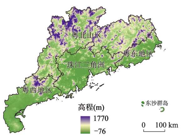
广东省作为中国对外开放的南大门,近40年来经济快速增长。2020年全省地区生产总值达11.08×10⁴亿元,同比增长2.9%,其中农业总产值7.91×10³亿元,同比增长9.0%;全省常住人口城镇化率74.15%,乡村户籍人口6858万人,乡村从业人员3509.31万人,城乡居民人均可支配收入比为2.49。广东省地貌类型复杂多样,山地、丘陵、平原和台地面积分别占全省土地总面积的33.7%、24.9%、21.7%和14.2%。地势总体北高南低,沿海多平原台地,北部多为山地和高丘陵,基于地理区位和经济发展差异,全省划分为珠三角、粤东、粤西和粤北山区4个经济区(图1)。根据广东省第三次全国国土调查,2020年初全省城市建设用地面积4.51×10⁵ hm2,建制镇建设用地4.47×10⁵ hm2,村庄建设用地8.08×10⁵ hm2。广东省乡村聚落呈现东西两翼平原台地密集、北部山区及中部稀疏的空间分布特征[22],具有低海拔、低坡度、邻河流、邻乡镇的空间指向性[21]。广东省辖21个地级市,122个县级行政单元。其中几个行政单元不参与本文村镇聚落体系分析:① 广州市的越秀、荔湾、海珠三区和肇庆市端州区的村镇斑块所剩无几,村镇聚落不成体系;② 深圳市全市各区无农村行政建制和农村管理体制。此外,东莞市和中山市虽为地级市却仅有市、镇两级建制,无县级行政单位,本文将其整体加入村镇聚落体系结构分析。因此,本文研究对象为广东省109个区(县)加2个地级市,共111个行政单元。
图1
2.2 数据来源
本文借鉴卫春江等[13]和黄万状等[16]的数据获取方法,利用村镇聚落斑块面积表征村镇聚落规模。文中的村镇聚落斑块用地特指为农村居民点用地类型,其数据来源于地理空间数据云(
2.3 研究方法
2.3.1 村镇等级规模体系的位序累积规模模型
2.3.2 村镇聚落体系的聚集性模型
式中:Df为分维。考虑到半径r的单位取值影响分维的数值,可将其转化为平均半径,定义平均半径为:
则一般有分维关系:
式中:Rs为平均半径;ri为第i个聚落斑块到区域几何中心的欧氏距离;S为聚落斑块个数;D为分维数。D反映的是聚落斑块围绕几何中心随机聚集的特征,称为聚集维数,表示聚落斑块分布从几何中心向周围腹地的密度衰减特征。已有研究表明,当D < 2时,聚落体系的斑块空间分布从几何中心向四周是密度衰减的;当D = 2时,村镇聚落体系的斑块分布在半径方向上是均匀变化的;当D > 2时,聚落体系的斑块分布从几何中心向四周密度递增,是一种非正常的情况[23]。
3 结果分析
3.1 1990—2020年广东省村镇聚落体系等级规模演化过程
3.1.1 广东省村镇聚落规模变化特征
1990—2020年广东省村镇聚落呈现出斑块数量逐渐减少、斑块总面积和平均斑块面积呈现先增后减的特点。村镇聚落斑块数量呈现逐年减少趋势,由1990年的14831个减少至2020年的13900个,且2005—2020年减少速率加快。聚落斑块总面积呈现先增后减的状态,村镇聚落总面积由1990年的4460 km2增加至2000年的4920 km2,随后下降至2020年的4257 km2;聚落斑块平均面积略有增加,最大聚落面积有明显先增后降趋势,而最小聚落面积和最大斑块指数则在小幅波动中维持稳定。最大斑块指数1995年上升至0.51%,2005—2020年间一直维持在0.12%(表1)。
表1 1990—2020年广东省村镇聚落斑块规模统计
Tab. 1
| 指标 | 1990年 | 1995年 | 2000年 | 2005年 | 2013年 | 2020年 |
|---|---|---|---|---|---|---|
| 聚落总数量(个) | 14831 | 14814 | 14758 | 14585 | 13664 | 13900 |
| 聚落总面积(km2) | 4460 | 4650 | 4920 | 4890 | 4170 | 4257 |
| 平均斑块面积(km2) | 0.301 | 0.314 | 0.333 | 0.336 | 0.305 | 0.306 |
| 最大聚落面积(km2) | 6.325 | 23.892 | 6.163 | 5.853 | 4.892 | 5.296 |
| 最小聚落面积(m2) | 106.687 | 204.124 | 207.424 | 201.533 | 201.533 | 106.819 |
| 最大斑块指数(%) | 0.14 | 0.51 | 0.13 | 0.12 | 0.12 | 0.12 |
3.1.2 村镇聚落位序—累积规模系数演变特征
广东省县域村镇聚落位序—累积规模系数β值范围分别为1990年的3.75×10⁵~7.00×10⁷和2020年的3.64×10⁵~4.00×10⁷,测定系数R2在0.907~0.997。广东省各行政单元村镇聚落体系发育程度差异明显,β值在1990年和2020年< 1.00×10⁷和≥ 1.00×10⁷的行政单元分别从63个和48个变化为65个和46个,占比从56.76∶43.24变化为58.56∶41.44(图2)。两年份111个行政单元的β值变异系数分别为105.99%和95.28%,表明30年间各行政单元β值离散程度趋向减少。从空间分布格局来看,1990—2020年广东省111个行政单元β值总体呈现西南高、东北低和沿海高、内陆低的特征(图3)。从变化趋势方面来看,1990—2020年有78个行政单元的村镇聚落体系等级规模保持稳定状态,出现萎缩和增长的行政单元分别为16个和17个,β值减少、不变和增加的数量分别占14.4%、70.3%和15.3%。研究期内β值增减的幅度普遍较小,其中,减少值占1990年β值比例≤ 50%和> 50%的行政单元分别为12个和4个,增加值占1990年β值比例≤ 50%和> 50%的行政单元分别为10个和7个。从空间分布上来看,β值下降区域集中于珠江口东岸和粤东沿海地区,上升区域较为集中在珠江口西岸。
图2
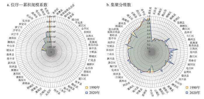
图2
1990年和2020年广东省111个行政单元村镇聚落位序—累积规模系数与集聚分维数分布
Fig. 2
Distribution plots of rural rank cumulative size coefficients and agglomeration fractal dimensions of 111 administrative units in Guangdong province in 1990 and 2020
图3

图3
1990—2020年广东省111个行政单元村镇聚落位序—累积规模系数变化
Fig. 3
Changes of rural rank cumulative size coefficients of 111 administrative units in Guangdong province, 1990-2020
3.2 1990—2020年广东省村镇聚落体系空间分布演化过程
广东省111个行政单元的村镇聚落体系空间分布在1990年和2020年均具有明显几何分形特征,各行政单元内村镇斑块的分布均呈现以其几何中心为核的向心聚集分布特征,斑块分布从中心向四周密度逐渐衰减,各行政单元村镇聚落体系是以其几何中心聚集发展的空间分布结构(图4)。1990年和2020年广东省县域村镇体系聚集维数D值范围分别是0.2737~0.9553和0.2737~0.9675(图2),测定系数R2在0.850~0.999之间,其中R2小于0.9的行政单元数在两个年份中仅有6个。不同行政单元的D值在1990和2020年均存在差异,D值越小,村镇斑块围绕中心分布越聚集,反之则围绕中心分布越均匀。1990和2020年111个行政单元的D值变异系数分别为24.45%和24.70%,30年间D值分布的离散程度轻微增加。从变化趋势方面来看,1990—2020年D值减小、增加和不变的行政单元分别占50.45%、47.74%和1.80%;其增减幅度均较小,其中,变化值占1990年D值比例在-1%~1%的行政单元最多,有44个;减少值占1990年D值1%~10%和10%以上的数量分别为21个和8个;增加值占1990年D值1%~10%和10%以上的数量分别为28个和10个。从空间分布来看,D值增加较为剧烈的地区集中在珠三角核心区和粤北地区,减少较多的地区主要分散在珠江口西岸、粤西和粤北地区。
图4
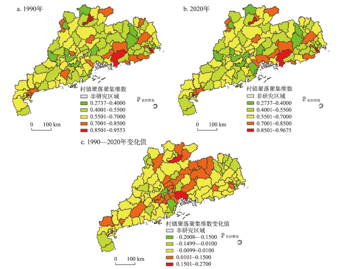
图4
1990—2020年广东省111个行政单元村镇聚落集聚维数变化
Fig. 4
Changes of agglomeration fractal dimensions of 111 administrative units in Guangdong province, 1990-2020
3.3 广东省村镇聚落体系演化驱动机制
3.3.1 村镇聚落体系演化的驱动机制
图5
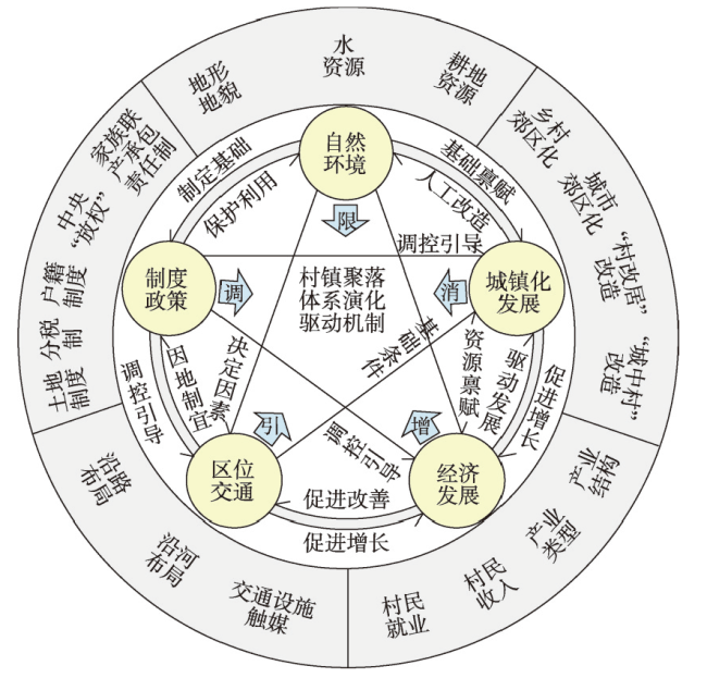
图5
村镇聚落体系演化的驱动机制
Fig. 5
The driving mechanism of rural settlement system evolution
自然环境是村镇聚落体系发展的基础本底,对村镇聚落的形成演化产生基础性影响,并对其拓展方向和规模有一定的限制作用,较大程度上决定了村镇聚落体系的空间形态和布局[24-25]。限制村镇发展的自然条件主要包括地形、地貌、水资源、耕地资源等[21]。平原和台地地区地形平坦、水网交织、土地肥沃,适宜生产和生活,村镇聚落易于形成并发展壮大,村镇数量和规模普遍较大。山地丘陵地区地形起伏较多,连片平坦用地较少,耕地零散分布,人地关系紧张,难以形成连片聚集的农村居民点,聚落规模普遍较小,村镇数量也较少[1]。2020年珠三角、粤东和粤西地区的村镇斑块平均面积为28.10 hm2,而粤北山区的村镇斑块平均面积仅为22.11 hm2。广东省111个行政单元1990年和2020年β值的空间分布表明,沿海的珠江三角洲平原、潮汕平原和湛江台地村镇聚落斑块面积较大、数量较多,聚落规模体系发育较好;而位于粤北山地丘陵地带的行政单元β值较小,村镇聚落斑块零散而细碎,聚落规模较为平均。丘陵山地地形也限制了山区村镇聚落的发展,从1990—2020年的β值变化看来,其规模和数量的提升较为缓慢。
经济发展是村镇聚落体系形成和发展的首要推动力,产业类型和结构直接影响村镇聚落体系的规模等级和空间分布结构。第一产业为主导的地区乡村聚落规模较小而布局分散,而第二三产业占主要比重的地区的乡村聚落规模较大并呈集聚分布特征[26]。2020年广东省珠江三角洲、粤东、粤西和粤北山区四大经济区地均生产总值分别为1.63×10⁸元/km2、0.46×108元/km2、0.24×108和0.08×108元/km2,村镇聚落体系β值表现为沿海区域较高,内陆山区较低,且高值和低值的区域均具有一定连片聚集特征(图3)。沿海经济较发达地区尤其珠三角地区“村村点火、户户冒烟”的乡村工业化加速了人口和产业在村镇持续聚集,推动农用地快速非农化,乡村聚落规模逐渐增大,部分发展成为小城镇。自20世纪90年代以来,部分乡镇企业经历了三资企业改制、产业园区化政策推动下的村镇级产业园建设[27],部分地区的产业集群形成专业镇[28]。2010年以来,广东省产业从劳动密集型向技术、资金和劳动密集型并举升级,原有企业所依托发展的乡村和小城镇随工业化进一步壮大。村民加建物业用于出租的需求持续增大,促进了聚落规模的扩张,乡村聚落布局逐渐从分散细碎走向连片集聚。县域内工业在镇村的遍地开花式发展使各个聚落均衡发展,致使多数村镇聚落体系等级规模位序变化并不明显。反之,位于内陆山区欠发达地区的村镇由于交通区位和资金等条件限制,二三产业的发展一直较为缓慢,面临着劳动力外流的空心化,村镇聚落规模普遍较小且布局分散。
城镇化是导致村镇聚落体系重构与消亡的直接驱动力。广东省尤其是珠三角地区的农村城镇化经历了外向型城镇化到区域中心城市引领的城市化两个阶段。20世纪80年代开始,外资对珠三角乡村地区的投资建设开启了“三来一补”的乡村工业化和城镇化进程,乡镇政府和村集体力推将农用地转化为工业用地,并在周边配套建设商业和道路交通设施[29],建设用地在乡村地区连片蔓延,民房与厂房混杂布局,形成了星罗棋布的小城镇和乡村城市化地区。21世纪以来,广州、深圳等区域中心城市的聚集作用逐渐凸显,以地生财经营城市的政府策略加速了全省各地的城镇化进程。位于市区和县城区周边的城郊村在郊区化作用下,农村居民点以外的大量土地被城市政府征收,遗留下被城市建设用地所包围的“城中村”[30];达到一定开发条件后,“城中村”被整体拆迁改造,村民被拆迁安置或回迁到原地新建的商品房,乡村聚落形态在此区域彻底消失,完全融入城市。城郊村从规模缩减数量减少逐渐走向融入城市。在远郊或偏远地区,城镇辐射带动范围以外的乡村则面临劳动人口持续向发达地区市、县和镇区流出,带来了人口空心化和旧居民点普遍衰败。另一方面,受传统观念影响,外出务工人口工资性收入回流促推返乡建房,形成了乡村聚落外新内旧的空间扩散趋向。
交通区位是村镇聚落体系形成和空间布局的引导性因素,并在其演化过程中起着催化剂的作用。交通设施是村镇与外界联系和资源交换的重要渠道,村镇聚落趋于沿路、沿河布局,道路等交通设施成为村镇聚落分布的骨架网络,引导其空间布局形态的演变。与市/县区之间交通联系的便捷程度直接影响村镇的规模和数量变化[21]。2020年广东省沿海地区(包括珠三角、粤东和粤西地区)和粤北山区公路网密度分别为1.33 km/km2和1.10 km/km2,两地相差达21.12%,广东省村镇聚落体系发育程度呈现沿海高、内陆低的格局,与其交通便捷度有重要的正向关联。新的交通设施尤其是交通枢纽的建设将激发村镇聚落形态的变化[31],引起村镇聚落空间格局的改变。在城镇化发展的前半阶段,区位的优越和交通的便捷能加速村庄尤其是集镇聚集人口提升规模;当小城镇聚集发展升级成小城市后,周边的乡村将由于城区的拓展而被蚕食吞并,村庄的规模和数量反而出现下降。
国家与区域的政策、制度制定与改革是村镇聚落体系变化的主导作用因素,相关政策或制度的实施对村镇的规模和数量的变化趋势具有重要的调控作用,影响村镇聚落体系发展方向。国家政策制度是最顶层的调控因素,改革开放、土地制度改革、分税制改革、家庭联产承包制建立、户籍制度改革以及中央对广东省农村集体开发土地的放权管理等政策直接刺激了全省尤其是珠三角地区的经济发展和城镇化进程[24,32],对村镇聚落体系的结构和布局带来多样化的影响和变化,成为村镇聚落发生演变的最根本驱动力。各级政府针对人地关系不协调、城乡二元结构分隔和城镇村聚落体系规模与空间布局不合理等的各项行政决策也对村镇聚落体系发展产生间接的影响。广东省政府公布实施的《珠三角城镇群协调发展规划(2004—2020)》和《关于推进产业转移和劳动力转移的决定》等政策为协调省内区域间发展不平衡,缩小城乡差距和乡乡差距作出规划布局与落实安排。前者强调对区域性交通基础设施的协调建设上,促进珠三角内外交通的连通性,提升外围地区与国内国际市场的接轨;后者则对珠三角地区的劳动密集型企业提出了转型升级的要求,珠三角部分企业的关停和“退二进三”的升级改造使一直以来与之唇齿相依的村镇聚落产生一定的规模萎缩和衰落[33],但也为一部分村镇发展带来了机遇。一方面部分村镇成功升级转型为高新技术企业或其配套服务产业的载体,加速了聚落规模的扩大;另一方面转移到粤东西北地区的劳动密集型产业为外围地区村镇带来更多的就业机会,吸引外来人口和外出人口回流,这类村镇的规模和数量因而得到一定增长。此外,广东省多年以来的农村“双到”扶贫政策,为粤东西北地区乡村集体经济的壮大和农民脱贫致富作出有力的保障,一定程度上促进了欠发达地区村镇聚落体系的发展。地方的制度创新也促进了村镇聚落体系的演化进程。其中农村股份合作制的创新突破了家庭联产承包责任制土地零散细碎的使用格局,实现了土地的规模化经营,为珠三角乡村地区的集体经济早期建立乡镇企业、建设厂房等物业出租和后期村级工业园建设创造了可能性[34],是解放农村生产力、促进农民向二三产业转移的重要制度基础,从而改变了珠三角地区乃至全省的村镇聚落体系结构。
3.3.2 广东省村镇聚落体系演化的空间关联区位类型分化及其归因
1990—2020年广东省不同行政单元村镇聚落体系的等级规模和空间分布结构具有较大差异,在相同的国家与区域政策背景下,不均衡发展的形成与其自然禀赋和交通区位具有密切关系。1978年改革开放以来,广东省经济社会快速发展与邻近港澳的区位带来的外资和技术引进息息相关,尤其是珠三角地区的乡村在近40年的发展中凭借良好的区位优势吸引了大量外资投入实现了乡村工业化的转型,形成独特的外向型城镇化“珠江模式”[35],而其他地区则发展相对缓慢。因此区位条件成为分析不同的村镇聚落体系差异化发展机制的重要考虑因素。为准确归纳总结广东省不同类型行政单元村镇聚落体系的发展规律,预测未来发展趋势,本文根据区位条件,从空间关联视角将111个行政单元分成城区型、近郊型、远郊型和山区型4类(表2),不同类型行政单元村镇聚落体系由于所处发展阶段和主导驱动因素的不同呈现出差异化的演变发展趋势(图6)。
表2 广东省村镇聚落体系分类特征、演化规律及优化重组模式
Tab. 2
| 区位类型 | 城区型 | 近郊型 | 远郊型 | 山区型 |
|---|---|---|---|---|
| 主要分布 区域 | 地级市的老城区、县级市和县的城区 | 地级市的新城区 | 地级市的外围县(市) | 粤北山区的清远市、韶关市、河源市和梅州市的16个外围山区县(市) |
| 城镇化发展 阶段 | 中后期、成熟期 (城镇化率> 70%) | 城镇化中期 (城镇化率50%~70%) | 城镇化中期 (城镇化率30%~70%) | 城镇化初期向中期 (城镇化率30%~50%) |
| 村镇聚落体 系发展阶段 | 融入城市发展阶段 | 成长阶段(双核并进的组团发展阶段) | 成长阶段(村镇聚落体系的强中心发展阶段) | 初期阶段(传统村镇空间组织发育阶段) |
| 2020年位序 累积规模系 数β值特征 | 逐渐减小趋于0,村镇聚落体系逐步瓦解,融入城市空间组织体系 | 随城镇化率提升而增大,进入城镇化后期后回落,与1990年相比β值以增长为主 | 随城镇化率提升而增大,在进入城镇化中期后出现回落,与1990年相比β值以增长为主 | 规模分布较均匀,等级规模序位特征不明显,整体水平较低,处于缓慢增长状态 |
| 村镇斑块空 间分布特征 | 城镇化率越高,村镇斑块越趋向于分散布局 | 高度的城乡用地混杂状态,聚落体系空间结构日渐松散 | 村镇斑块在行政单元中趋于离心外围扩散 | 村镇斑块呈现沿交通线为发展轴延展布局的聚集特征 |
| 村镇空间优 化重组调控 建议 | 融入城市整体发展:土地、物业、产业、村民的制度转变、物质空间到社会空间的城乡融合发展 | 城乡分组团发展:双核驱动模式,形成“县域副中心—建制镇—中心村—一般村”的乡村组团结构,乡村组团与城区组团产业错位互补,市场、技术、资源要素互通,组团间相对独立发展 | 村镇中心地等级体系发展:“县城—建制镇—中心村—一般村”四级传导的传统中心地发展模式,构建 “县—镇—村”三级全域全覆盖的乡村公共服务体系,土地利用高效集约突显低密度和生态化的村镇空间融合体特征 | 泛中心链式集群化发展:强化县域内外交通与通讯基础设施建设,依托道路交通构建多链交织山区型村镇空间组织网络,促成个体乡村集群化和组团化发展,充分借力城乡网络化和全球生产网络发展的外援动力,构建泛中心的链式生产生活服务覆盖模式 |
| 行政单元 名单 | 梅江区、蓬江区、江城区、赤坎区、云城区、香洲区、龙湖区、金平区、源城区、惠城区、天河区、白云区、黄埔区、番禺区、禅城区、江海区、霞山区、清城区、榕城区、浈江区、汕尾城区、茂南区、湘桥区、东莞市、中山市 | 澄海区、鼎湖区、金湾区、斗门区、濠江区、武江区、新会区、南沙区、从化区、花都区、潮阳区、顺德区、三水区、高明区、潮安区、揭东区、云安区、增城区、潮南区、南海区、曲江区、惠阳区、电白区 | 南澳县、兴宁市、雷州市、德庆县、五华县、龙门县、陆河县、四会市、封开县、紫金县、东源县、梅县区、徐闻县、信宜市、普宁市、海丰县、鹤山市、南雄市、惠东县、博罗县、台山市、阳春市、麻章区、廉江市、化州市、高州市、广宁县、英德市、揭西县、新兴县、罗定市、龙川县、陆丰市、开平市、恩平市、阳西县、阳东区、吴川市、遂溪县、坡头区、怀集县、高要区、清新区、佛冈县、饶平县、惠来县、郁南县 | 仁化县、连平县、连州市、和平县、连山壮族瑶族自治县、连南瑶族自治县、翁源县、阳山县、始兴县、乳源瑶族自治县、乐昌市、新丰县、平远县、丰顺县、大埔县、蕉岭县 |
图6
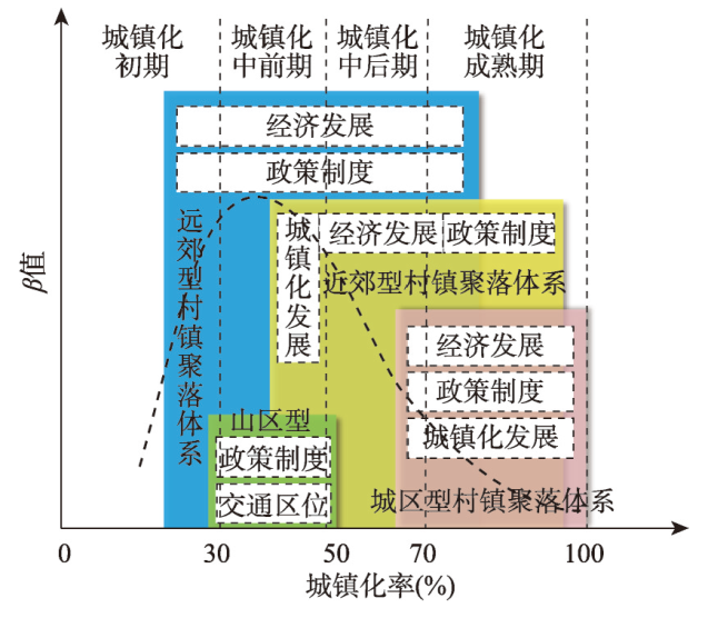
图6
广东省不同类型村镇聚落体系所处城镇化发展阶段及其演变主导因素
Fig. 6
The urbanization development stages of different types of rural settlement system and their evolution leading factors in Guangdong province
城区型行政单元为地级市的老城区或者是县级市和县的城区,2020年25个行政单元中有20个城镇化率超过80%,普遍进入城镇化后期成熟阶段。村镇聚落体系呈现斑块规模小数量少、空间分布破碎化特征,多表现为“城中村”或“城边村”状态。2020年仅有6个行政单元的β值≥ 1.00×10⁷,其余值较小。β值≥ 1.00×107的行政单元,村镇等级规模体系较完整,村镇规模较大数量较多;城镇化率超过80%且越接近100%的多数行政单元β值越小并渐趋于0。与1990年相比,城镇化率60%~80%的行政单元2020年β值以增加和不变为主;城镇化率大于80%的行政单元β值以减少和不变为主。城区型村镇聚落体系2020年D值分布随城镇化率的增大呈现上升趋势,表明城镇化率越高,村镇斑块在各行政单元中越趋向于分散布局。同时,与1990年相比,2020年D值以增加为主。经济和城镇化的发展驱动城市建设用地版图不断外拓,城市政府通过各种行政手段,促使村镇融入城市,聚落体系被分散瓦解逐渐走向消亡。此类行政单元经济进入三产为主、二三产业共同驱动发展阶段,吸纳大量就业人口聚集,带来城镇化加速发展,加剧了对城市建设用地需求。政府为增加建设用地规模,通过编制或调整城市规划将城区外围用地纳入城市建设范围,位于城区边缘的乡村用地被城市政府征收并返还一定比例的留用地,原来的“城边村”在经济发展、城镇化和政府行政调控下变成了“城中村”。凭借良好区位,村民在集体留用地上建设商业或厂房物业并将原有住房加高改造以获取更多的租金收益,“城中村”在密度和规模上都发生一定增长;当“城中村”所在区位优势凸显时,政府将启动“旧村改造”以释放土地增值红利,乡村聚落物质形态伴随改造彻底消失。城区型乡村融入城市的另一种形式是“村改居”改造,政府通过将“城中村”或“城边村”撤销原村民委员会改建为城市居民委员会,尝试使用城市社会管理模式代替原有农村社会管理模式。虽然改制之后乡村社区变成了城市社区,村民户口变成了市民户口,原来的乡村在行政管理上被城市化,但是实质上多数乡村的集体组织结构依然存在,集体所有的土地性质不变,村民聚居点仍基本保留原来的聚落形态,享受的社会保障和公共服务依然由村集体承担,是一种表面上的“城市化”。
近郊型行政单元主要为地级市的新城区,2020年23个行政单元城镇化率有14个集中在50%~80%,处于城镇化中前期到成熟期。2020年β值有11个≥ 1.00×107,其余12个较小。此类村镇聚落体系的等级规模发展存在一定分异,既有体系发育成熟均衡分布,斑块数量多的行政单元;也有等级规模比较均匀,斑块数量较少的行政单元。从2020年β值分布情况看来,该类村镇聚落体系β值随行政单元的城镇化率增大而增大,在城镇化率70%左右达到最高峰,在70%~100%阶段出现轻微回落。与1990年相比,2020年β值以不变和增长为主,仅有4个行政单元出现减少,说明此类行政单元的β值以稳定和增长为主要发展趋势,呈现村镇聚落体系与城镇化同步发展的状态。此类村镇聚落体系2020年的D值分布随城镇化率增大呈上升趋势,表明城镇化率越高,村镇斑块在各行政单元中越趋向于分散均匀布局。此类村镇聚落体系在改革开放之初随乡村工业化发展,吸引大量本地和外地劳动人口聚集,各级聚落普遍发生扩张;20世纪90年代随分税制等制度改革,乡镇企业出现倒闭或转制,依托这些企业发展壮大的部分村镇出现衰落。但近郊型村镇得益于与中心城区的邻近性和较低的地租,部分规模较大经营良好的乡镇企业成功转制;另一方面,企业倒闭的村集体吸取经验,对集体经济的经营策略转为在集体用地上建设物业出租以获取租金收入,乡村的工业用地经历了从自发聚集到政府统一规划的过程,逐渐形成大小各异的村级镇级工业园,园区所依托发展的村镇聚落规模持续扩大,部分地区形成了具有产业簇群的专业镇。2003年开始,村级工业园由于土地利用效率低等问题经历多次整顿;同时,城区外扩过程中周边乡村逐渐被政府通过征地、“三旧”改造和“村改居”形式兼并融合,村镇聚落规模数量出现减少。总体来说,此类村镇聚落体系在经济发展、城镇化和政策制度共同作用下从蓬勃发展,到出现一定程度的优胜劣汰,未来仍将保持着一定的数量与规模。这一过程中村镇空间与城市建设愈加紧邻分布,呈现出高度的城乡用地混杂状态,村镇聚落体系空间结构日渐分散。
远郊型行政单元村镇聚落体系位于地级市外围县(市),2020年47个行政单元中有43个城镇化率集中在30%~70%的城镇化快速发展阶段。远郊型行政单元在4种类型中城镇化率相对较低,其农村人口和乡村用地规模占比较大,多数行政单元村镇数量和规模都较大。2020年β值有28个≥ 1.00×10⁷,其余19个< 1.00×10⁷,此类村镇聚落体系发展同样存在一定分异。从2020年β值分布情况看来,该类行政单元村镇聚落体系β值在城镇化率30%~40%达到高峰后回落。2020年β值与1990年相比以稳定为主要趋势。远郊型行政单元村镇聚落体系2020年的D值分布随城镇化率的增加呈上升趋势,表明城镇化率越高,村镇斑块在各行政单元中越趋向于分散均匀布局。此类村镇聚落体系在20世纪80年代乡村工业化促进下从农业村转向工农兼业村,但在乡镇企业式微后,县城产业聚集带动的城镇化效应渐强,城乡差距逐渐加大,户籍制度的松动和经济利益的驱动使得乡村人口开始“离土离乡”,持续外流至县城或珠三角等发达地区打工,部分村镇聚落出现“空心化”;得益于宅基地制度保障和退出机制的牵制,外出打工者并未永远离开家乡,多数赚钱回乡后在旧村外围沿路建新房,但在岭南传统宗族理念的影响下,老宅依然原址保留,使聚落呈内旧外新圈层式发展状态[36],乡村聚落规模不减反增,空间布局趋向离心外围扩散。2005年以来,建设社会主义新农村和乡村振兴的国家战略保障,各项资金、技术和人才持续向外围欠发达乡村地区投入,多种因素结合使得远郊型村镇聚落体系在稳定中有所增长。
山区型行政单元为粤北山区的清远市、韶关市、河源市和梅州市的16个外围山区县(市),2020年城镇化率为32.58%~55.21%,处于城镇化初期和中前期。2020年β值除翁源县外其余行政单元均低于1.00×10⁷,村镇斑块规模小而均匀,数量较少,村镇聚落体系发育程度普遍较低,空间分布受丘陵山地所限较为分散。与1990年相比,2020年β值以不变为主,增长的仅有3个行政单元,村镇聚落体系正处于缓慢发育的过程。山区型村镇聚落体系2020年的D值分布随城镇化率的增加呈上升趋势。与1990年相比2020年D值以增加为主,村镇斑块在各自行政单元中趋于分散布局。山区型村镇多数产业发展较为薄弱缺乏内生动力,基本形成以一三产为主、二产为辅的经济结构,总体产值较低。区位偏远交通不便和用地破碎零散是其最大劣势,工业由于缺乏聚集效应和资金投入难以成规模发展,大量农村劳动力外流导致乡村“空心化”。省政府为平衡区域发展实现优势互补,长期以来制定实施了大量扶持和对口支援山区经济发展的政策,政策与资金支持是山区村镇发展的最大动力。省政府对区域交通和通信基础设施的大力投入,致力帮助山区克服交通不便的劣势,为外部资金与技术进入,促进山区村镇发展铺平道路。因此,山区型村镇聚落呈现显著的沿交通线为发展轴延展布局聚集的特征。
3.4 广东省村镇聚落体系分类发展及优化重组模式
城区型行政单元城镇化水平普遍较高,此类地区中除了需要保留的历史文化村落外,多数村镇聚落将融入城市空间组织体系(图7)。乡村融入城市是一个循序渐进的过程,两者在土地、物业、产业、文化和治理体系等方面差异巨大,转型路径的选择影响着城乡融合的速度与质量。快速城镇化带来失地农民、集体资产分配不公等诸多问题。土地从集体所有转向国有过程中产生的土地出让金如何在政府和村集体之间合理分配,“旧村改造”中物业的拆迁补偿和村民回迁安置,村内原有产业能否升级改造融入城市产业体系,村民户口转变与身份认同及其社会保障制度的配套,社区治理方式从村委会管理转换为居委会管理,原集体所有资产的管理和运营,公共服务和市政基础设施从村集体自理变为纳入城市一体化配套管理,乡村原有的文化与习俗如何与城市文明融合得以传承,这些问题的解决方式将决定乡村能否顺利融入城市,村民真正变成市民,实现从“物的城镇化”到“人的城镇化”[37],从物质空间到社会空间的真正城乡融合。
图7
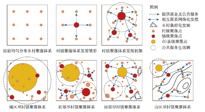
图7
村镇聚落体系成长历程及4种类型发展优化重组模式图
Fig. 7
The growth process of the rural settlement system and the four types of spatial optimization and reconstruction models
近郊型行政单元在城市新区建设与乡村工业化发展共同作用下城乡用地和景观风貌混杂,用地效率和城镇化质量偏低,在高质量城镇化和农业农村现代化的新要求下,需要系统梳理区分城市和乡村的经济社会文化物质多维度空间。在城区对外围村镇的极化作用和扩散作用并存背景下,为削弱极化效应对村镇资源的虹吸作用,并充分利用城区的技术和产业扩散效应,未来该类县域村镇体系的空间组织应采用以县城中心与乡镇副中心共同驱动的双核发展模式。在县域层面划分城区组团与乡村组团,两者应加强交通设施连通性、保持双向市场开放和要素流动,在空间、产业和公服等方面形成相对独立互馈的系统。位于城区组团的村镇应用城区型村镇发展模式,循序渐进高质量融入城市系统。另外,在远离县城中心的外围培育一个具有良好交通区位优势的建制镇作为县域副中心,形成“县域副中心—建制镇—中心村—一般村”的乡村组团结构,副中心功能以面向村镇的产业发展和生产性与生活性服务为主导。乡村组团应充分利用和发挥邻近城区的区位优势和生态优势,与城区组团功能错位互补,强调生态绿色的发展理念指导下积极承接城区产业转移并实现农产品加工业、都市农业和观光休闲旅游业三次产业融合发展。保护传承乡村优良传统文化风俗和景观风貌,防止城市资本下乡导致乡村性丧失。充分利用“互联网+”提升产业规模与等级[35],以专业化产业聚集为导向规划建设中心镇和中心村,制定适应本地的人口吸引政策,加强自身的内聚竞争力;以镇为核心建设公服设施共享的村镇发展共同体,保证乡村组团形成相对独立发展系统,避免过多受到城区组团城镇化虹吸聚集作用。
远郊型行政单元村镇聚落体系处于聚集成长期,远离城市辐射作用影响,经济发展相对落后,劳动人口流出明显。其县城发展处于起步或成长期人口集聚能力有限,城镇化、工业化、农业现代化驱动作用并存。未来应该强调县城在县域城镇村体系发展中的核心引领作用,采用“县城—建制镇—中心村—一般村”四级传导的中心地发展模式[3],凸显县城“城尾乡头”的地域中心辐射功能,强化建制镇的县域次级中心地功能,形成产业、市场、资源和公服四级联动的村镇有机体空间组织形态。县城形成劳动密集型产业和服务业聚集区促进人口聚集,建制镇加强农产品加工和农业服务业的培育,中心村提高农业现代化水平和示范带动作用,一般村提升农业生产专业化程度,四级联动共同完善县域现代工业和农业产业体系。鼓励和引导有条件的乡村实现“电商聚集型”产业发展,通过现代电子通信技术跨越时空区位劣势,与区域甚至全球的生产网络有效连接[35]。保护县域内广阔的生态空间,为区域保留生态安全屏障同时积极发展生态旅游业,凸显乡村生态服务与文化功能。建构“县—镇—村”三级全域全覆盖的乡村公共服务体系,县城提供县级公共服务和产业服务配套,以中心镇和中心村为核心,建设提供分级综合服务的高质量社区生活服务圈[38];提升县城和镇区的人口聚集度,为常住人口提供城乡均等的公共服务以吸引外出人口回流及外来人口进驻。在促进城镇化、工业化和村镇聚落发展的同时应注意土地利用的高效集约,突显低密度和生态化的村镇空间融合体特征。
山区型行政单元由于县城规模较小聚集能力不足,经济发展水平较低,农业和工业现代化程度较低。由于山区聚落点分散而规模小,交通联系不便,难以应用中心地理论进行公共服务设施布局以实现服务效率最大化,公共服务覆盖程度较低。未来山区型村镇聚落体系的空间组织应以县域交通主干道串联的县城、镇和村组成县域发展主链,以次干道连接的镇村形成多条发展副链,并通过车道、水道、绿道和驿道等交通网络辐射带动周边其余村镇发展,构建泛中心化的村镇网络空间组织体系。通过多链交织构建村镇网络,促成个体乡村集群化和组团化发展[39],使原来分散弱小的村落联结成为一个有机整体,提高产品品牌影响力和竞争力,增强乡村产业发展的生命力。强化县域内外交通与通讯基础设施建设,加强山区村镇与外部发达地区的线下与线上网络连接,促进县域内外和城乡之间的要素与资源的流通,在“互联网+”背景下促进偏远乡村地区市场网络对接全球市场网络体系,充分借力城乡网络化和全球生产网络发展等外援动力,增强乡村发展内源动力。依托特有的生态环境资源优势融合发展一二三产,鼓励发展特色化、产业化、专业化农业和生态旅游业,充分发挥山地乡村的农业经济价值、生态景观价值和社会情感价值。通过车道、绿道、驿道和水道等交通串联区域内特色村镇形成乡村振兴发展带。选取发展链上条件较好、位置适合的村镇分级布置公共服务设施点、旅游驿站和物流网点,构建泛中心的链式生产生活服务覆盖模式,确保服务范围内的村民享受到公共服务覆盖,游客享受到乡村旅游服务,生产要素实现快速无碍流通。针对贫困山区长期外出人口和“两不具备”的搬迁移民,建议制定合理宅基地和承包地退出机制,鼓励将原有宅基地和承包地使用权进行资金变现或置换搬迁物业。
4 结论与讨论
4.1 结论
(1)广东省县域村镇聚落体系等级规模具有显著区域差异特征,其位序累积规模系数呈现西南高、东北低和沿海高、内陆低的空间格局。1990—2020年广东省111个行政单元的β值下降区域主要集中于珠江口东岸和粤东沿海地区,上升区域主要在珠江口西岸,其他区域变化较小。村镇聚落斑块普遍呈现以各行政单元几何中心向心聚集分布特征。
(2)自然本底、经济发展、城镇化水平、交通区位、制度与政策等因素相互作用、共同驱动村镇聚落体系的形成和发展演变,不同类型和发展阶段的村镇聚落体系其耦合驱动机制具有差异性。城镇化发展成熟阶段的城区型村镇聚落体系规模小数量少,村镇聚落逐渐消亡并融入城市;伴随城镇化和工业化近郊型村镇经历了优胜劣汰并保持着数量与规模的稳定,城乡用地混杂发展使村镇空间组织日渐松散;远郊型村镇经历要素外流出现“空心化”,村民回乡建房和宅基地退出机制掣肘等使其规模持续稳定增长,空间形态呈现离心向外围扩散;偏远山区型村镇在政策制度的支持下缓慢发展,沿交通线为发展轴布局的空间组织原则使其渐趋于沿道路聚集。
(3)基于不同类型村镇聚落体系的演变趋势和发展规律,有针对性地提出不同空间优化重组策略,以增强村镇发展的内生动力。城区型村镇聚落体系重点关注融入城市后土地、物业、产业、文化、治理等体系转变,引导从物质空间到社会空间的城乡融合。近郊型村镇聚落体系采取双核双组团发展模式,在城区组团以外,构建“县域副中心—建制镇—中心村—一般村”结构的乡村组团,城乡组团间在市场、技术、资源要素互通并互促发展。远郊型村镇聚落体系采用中心地发展模式,形成“县城—建制镇—中心村—一般村”四级空间组织体系,推动土地利用高效集约、低密度和生态化的村镇空间融合体建设。山区型村镇聚落体系倡导泛中心链式集群化发展,依托线性交通构建多链交织山区型村镇空间组织网络,促成个体乡村的集群化发展,充分借力全球生产网络与城乡网络的外援动力,构建链式生产生活服务覆盖模式。
4.2 讨论
(2)面向城乡融合发展和重塑城乡网络化的时代重大需求,城—镇—村有序的空间组织极为重要,县城作为县域城镇化与乡村振兴有机衔接的重要增长极,构建围绕县城为核心空间组织的空间规划理论尤为重要。在中国县域农业农村现代化进程中,有待进一步完善县城、重点镇(专业镇)和村的空间组织规划技术规程,研发兼顾可达性和效益性的城乡基础设施和公共服务设施优化配置技术模型,构建县—镇—村一体的垂直和横向联系产业集群体系,形成城乡一体化的产业全价值链体系,并探索兼顾人地关系协调和农业农村现代化需求的村镇生产生活圈建设科学路径,将促进县—镇—村一体化的乡村振兴地域综合体的建设[40],实现城乡聚落体系融合一体的空间优化重构。
参考文献
Spatial distribution characteristics and optimized reconstructing analysis of rural settlement in China
DOI:10.13249/j.cnki.sgs.2016.02.002
[本文引用: 3]

This study focuses on the distribution characteristics, effect factors and optimized reconstructing analysis of rural settlement in China. Based on electronic map data in 2012 and socioeconomic data of counties in China, the spatial distribution pattern of rural settlement and effect factors have been examined using model of the average nearest neighbor distance and geographical detector method, while the background and mode for rural space optimization reconstruction were analyzed. Main results for this study are as follows: 1) the rural settlement spatial distribution mode consists of cluster, random and uniform discrete distributions in China, while the regional differences were significant. The density of rural settlements is greater in the southeastern region than in the northwest region with Hu Huanyong's population distribution line for the boundary in China. There were a variety of characteristics for the rural settlement distribution in different type of regions. The spatial distribution of rural settlement was intensive, and those spatial distribution modes were mainly random and disperse with a short average nearest neighbor distance in plain areas. On the other side, the density of rural settlement was low, and those spatial distribution modes were mainly cluster relatively with a long average nearest neighbor distance in highland and cold areas and fringes of the desert. In addition, the density of rural settlement was high, and those spatial distribution modes were mainly random in the intersected transition zone between hill and mountain. 2) The dual factors affect the rural settlement distribution from traditional and economy. Although the traditional factors still play a significance role, the influence of the economic developed more and more obviously. There were a large amount of factors attributing to impacting rural settlement distribution, the spatial form of production and life space, including natural topography and water resources natural conditions, etc. That also included traffic condition, industry, economic development level and agricultural modernization. 3) With factors of production non-agriculture in rural region, the rural space need be a reconstructing optimization. The priority selection is to rebuild village-town system for optimizing rural physical space. Theoretically, village-town system is a sort of hierarchical structure, consisting of central regional town, general agricultural town, central village and basic village. 4) The multiple modes will been made use of restructuring rural space in different geographical areas, including balance forms of radiation, radiation disequilibrium forms, multicore equilibrium forms and corridor layout pattern or mixed modes. From the system and the hierarchical logic level to deconstruct the rural space theory for optimization, a reasonable village-town system is rebuilt orderly, which will provide a scientific basis for urban and rural urbanization.
中国村庄空间分布特征及空间优化重组解析
DOI:10.13249/j.cnki.sgs.2016.02.002
[本文引用: 3]
以中国电子地图数据和分县经济社会数据为基础,利用最邻近距离R指数模型分析中国村庄分布模式格局,结合地理探测器的研究方法对影响因素进行探测识别,同时解析乡村空间优化重组背景和模式。研究得出以下主要结论:① 中国村庄空间分布呈现出聚集、随机、离散均匀分布的并存空间分布模式,村庄空间分布模式区域差异特征显著。东南半壁的村庄分布密度远大于西北半壁,不同地域类型区的村庄空间分布模式表现出各异的特征。平原地区的村庄空间分布密集,空间分布模式以随机、分散为主,村庄之间邻近距离较近。高寒山区、沙漠边缘地带,村庄空间分布密度极低,村庄之间邻近距离偏大,村庄空间分布相对聚集。丘陵、山地交汇过渡地带,村庄空间分布密度较大,空间分布模式偏向随机分布。② 村庄分布受到传统因素和经济发展双重因子的影响,传统影响因素依然在发挥作用,但经济发展的影响愈加明显。不同区域地形、水资源条件对村庄分布影响显著。交通条件、产业非农化、经济发展、农业现代化发展对乡村生活、生产空间的空间形态和分布模式产生剧烈影响。③ 伴随乡村各种生产要素非农化流失,村庄空间亟待优化重组,优化以镇区为依托的中心村-基层村体系空间组织结构应为乡村物质空间优化重组有效选择。④ 在不同地域类型区域,村镇格局的空间优化重组形态可以采用放射均衡、放射非均衡、多核心均衡、走廊式布局模式及混合模式。
On planning organization of rural settlement system
试论乡村聚落体系的规划组织
Service area of settlement and settlement system at the county level
聚落服务范围与县级聚落体系
The history and current trends of research on rural settlement geography in China
DOI:10.11821/xb198804003
[本文引用: 2]
In ancient China, there was no systematic research on rural settlement. What we can see today on ancient rural settlement is the general description in local records, novels and travels. Xu Xiake──the great ancient geographer, born 400 years ago, was the first one whobegan the research and record of rural settlement in China.The systematic research on rural settlement was initiated in 1930’s when French scholar Jean Brunhes’ a Geographie Humaine?was translated into Chinese, which had a fundamental influence on the circle of geographical science in China.. Before the foundation of the People’s Republic of China, the Chinese ge ’graphers had carried out some geographical researches on rural settlement, including: (1) research on the theory of settlement geography; (2) the systematic research on rural settlement in a given region; (3) studies on towns; (4) rural settlement research as apart of regional geography. So far as contents concerned, all the recesarches made then put emphasis on the explanation of the cause-effect relationship between scitlement and its environments.Since the foundation of the People’s Republic of China, the research on rural settlement geography has experienced three main phases: (1) In the early 1950’s, because of the improper treatment of human geography in China, fewer and fewer geographers were engaged in the field; (2) During 1958-1959, a large number of geographers participated in the planning of People’s Commune, meanwhile, the rural settlement planning, as a part of the People’s Com-mune Planning, was emphasized; (3) Since the hate oof 1970’s, with the improvement of rural ceonomy and the new coming phase of town-village construction, the importance of research on rural settlement geography has been recognized. Meanwhile, the new research fields, such a. territorial management, have provided rural settlement geography with a wide range of research projects. Moreover, the focus of rural s-’ttleinent geography has been shifting from the explanation of relationship between settlement a.d its environments to predicting, planning and designing of rural settlement for future development.The current trends of research on rual set dement geography in China are as following:(1) to serve the reform, management, rational distribution and planning of rural settlement;(2) researches on the tran,formastion, migration of rural population and the trends, sizes and processes of rural urbanization; (3) the theoretical synthesis of rural settlement geography; ( 4) the quantitative approach: (5) the analysis of new types of man-land relationship, in or-dcr to harmonize the settlement with economic development and its environments: (6) enhan-cement of the research on rural settlement geography within regional geography.
我国农村聚落地理研究历史及近今趋向
DOI:10.11821/xb198804003
[本文引用: 2]
本文论述了农村聚落地理学的研究对象,分析了我国农村聚落地理研究的各个阶段及其研究特点,提出了我国当前开展农村聚落地理研究的意义、主要内容和有待解决的重大问题。
Evolution paths and the driving mechanism of the urban-rural scale system at the county level: Taking three counties of Jiangsu province as an example
DOI:10.11821/dlxb201812009
[本文引用: 4]
In the context of the new era, it is of great theoretical and practical significance to promote urban-rural integrated development and rural revitalization by exploring the evolution paths and the driving mechanism of the urban-rural scale system. In this paper, we examined the evolution paths and the driving mechanism of this system at the county level based on both the land change survey data and remote sensing data in 1995 and 2015, when taking three counties of Jiangsu province as an example, namely developed Zhangjiagang, moderately-developed Taixing, and less-developed Lianshui at different levels of economic development. Based on the empirical study, in this paper, three typical evolution paths of the urban-rural scale system at the county level in Jiangsu province were summarized, and they fell into three types: Developed County, Moderately Developed County, and Less Developed County. In this case, some conclusions can be drawn as follows: (1) the number of settlements in the county decreased, but the total size increased; (2) the total size of rural settlements decreased, and the size of cities and towns increased at different speeds, when the town size gradually exceeded the urban size; (3) the number and the built-up area of high grade settlements increased, while those of low grade settlements decreased; (4) the polarization feature of the county's development became increasingly significant before gradually becoming weak; (5) the characteristics of the spatial cluster concerning the urban-rural scale system became increasingly significant, and the number of hot-points increased in the county area; (6) urban and rural construction land constantly expanded, when Chengguan town and key towns experienced the main change; (7) the spatial pattern of the urban-rural scale system evolved from the single center to double centers, and then to multi-centers. Furthermore, there were two common characteristics, namely urban-dominant effect and clumped-distributive effect, in the developing process of the urban-rural scale system in different counties. Then, based on the analysis of the key influencing factors, in this paper, the driving mechanism of the urban-rural scale system at the county level was put forward. In this study, economic growth, urbanization, transport network, and institutional management stand for four ways to propel progress. They are like the four wheels of a car, reinforcing and depending on one another and forming an integrated whole, in which the urban-rural settlement system constantly evolves.
江苏典型县域城乡聚落规模体系的演化路径及驱动机制
DOI:10.11821/dlxb201812009
[本文引用: 4]
新时代背景下,深入开展县域城乡聚落规模体系研究对促进城乡融合发展、推动乡村振兴战略的实施具有重要的理论意义和实践价值。本文从苏南、苏中、苏北选择张家港市、泰兴市、涟水县3个典型县市作为研究案例地,利用1995年和2015年遥感影像数据和土地利用数据,构建了县域城乡聚落规模体系的评价方法,对县域城乡聚落规模体系的时空演化过程进行了实证分析,发现不同类型县域城乡聚落规模体系的演化路径既有明显差异,也存在一般性路径,而且演化路径具有显著的城镇主导效应和集群分布效应。在深入分析经济发展、城镇化、交通网络、制度与管理4种主要影响因素基础上,进一步提炼出县域城乡聚落规模体系演化的“四轮”驱动机制。研究结果有助于深入认识城乡聚落有机整体的系统观,为推动城乡聚落优化重构提供了新的研究视角和方法支撑。
The village system scale structure prediction: A case of the Shache county
新疆村镇体系规模结构预测研究: 以莎车县为例
The changing distribution patterns of rural settlements during the process of urbanization: The case of Gongyi (1929-2013), China
县域聚落分布格局演变分析: 基于1929—2013年河南巩义的实证研究
DOI:10.11821/dlxb201512002
[本文引用: 2]
基于河南省巩义市1929-2013年的村庄数据,从位序—规模角度着手,使用齐夫指数、分形维数以及基尼系数,分别测度了近百年来县域聚落分布格局的演变。相对于城市,巩义市聚落等级规模具有如下特征:① 齐夫指数偏小但增长较快。大聚落发育不突出,具有农村聚落特征;但聚落规模越大,规模增加的速度越快,且二次项模型优于线性模型。② 分形维数偏大但降速加快。聚落体系等级差异增加,规模分布趋于集中。县域聚落规模只有增加到一定程度才能与城市表现出同样的规律。③ 聚落规模大小的基尼系数相对较小但增加显著,且增长率在1990s后加速,这与当地的城镇化发展过程具有密切关联。在空间上表现如下特征:① 沿河线状格局变化。核心聚落由“沿河平原线状”格局主导逐渐向“平原—丘陵片状”格局转变。② 网络等级结构形成。高等级聚落数量增加且规模增大,聚落等级增加,最终形成市场原则的5级等级结构。③ 核心聚落转移替代。县城迁移、工业化与城镇化带来聚落位序—规模变化,使核心聚落出现空间改变。
A preliminary study on the spatial structure of rural settlements in Guanzhong Region of Shaanxi Province
陕西关中地区乡村聚落空间结构初探
Configuration of the public service facilities in Suzhou rural area on the background of the urban and rural integration
城乡一体化背景下苏州村镇公共服务设施配置研究
Research progress and prospect of spatial evolution and optimization of rural settlements
乡村聚落空间演变和优化研究进展与展望
Rank-size rule for rural settlements
DOI:10.1016/0038-0121(84)90046-6 URL [本文引用: 3]
A rethink of the rank-size rule for rural settlement in traditional agricultural areas: A case study of Zhoukou city
传统农区村落位序—规模法则的实证研究: 以周口市为例
Change of settlement size in the less development agricultural plain area under the background of rapid urbanization
快速城镇化下欠发达平原农区的聚落规模变化
An empirical study on rank cumulative size model of rural settlements in the Hehuang area
DOI:10.11821/dlxb202106012
[本文引用: 4]
Scientific determination of rural settlement system is one of the keys to implement the strategy of rural revitalization and promote the modernization of agriculture and rural areas. Meanwhile, understanding the distribution law of rural settlement size is helpful for the optimization of rural settlements. In order to provide a reliable theoretical basis for the study of rural settlement size distribution and the optimization of rural settlement system, this article took the Hehuang area as an example, and explored a more accurate expression and law of Rank Cumulative Size Model based on the original Rank Cumulative Size Model. Then we examined the applicability and accuracy of the model in rural settlement size distribution compared with the Rural Rank-Size Rule. We also studied the characteristics and evolution law of rural settlement size distribution in the study area. The results show that: (1) Rank Cumulative Size Model is a monotonously increasing concave function (P ≥ 1), and its expression varies with the change of the Pareto coefficient of rural settlements. When 1 ≤ P < 1.20225, Si = aln(Ni) + b, there is a positive correlation between the fitting coefficient a and the size of first settlements. When P ≥ 1.20225, $S_i=be^{aln(N_i)}$ the coefficient of variation of settlement size and the size of the first settlements are negatively correlated with the fitting coefficient a, and positively correlated with the fitting coefficient b. (2) Rank Cumulative Size Model is more suitable for the study of rural settlement size distribution in Hehuang as it has better applicability and accuracy; while the Rural Rank-size Rule is not applicable. (3) The rural settlement size in Hehuang nearly shows the equilibrium distribution pattern of Pareto coefficient 2 and tends to be more concentrated. In the future, the rural settlements should be concentrated in areas with superior natural and socio-economic conditions, and the layout of regional rural settlements and villages should be planned reasonably. Based on this, we can develop a rural revitalization path with the harmonious coexistence between human and nature, as well as between urban and rural development.
河湟地区乡村聚落位序累积规模模型的实证研究
DOI:10.11821/dlxb202106012
[本文引用: 4]
科学确定乡村聚落体系是落实乡村振兴战略和促进农业农村现代化的关键之一,研究乡村聚落规模分布规律有助于乡村聚落体系优化。基于理论假设推导出了位序累计规模模型的准确表达及其规律,在此基础上,比较研究了位序累计规模模型和乡村位序—规模法则在河湟地区的适用性和准确性,厘清了河湟地区乡村聚落规模分布的特征和演变规律。研究显示:① 位序累积规模模型是一个单调递增的凹函数(P ≥ 1),函数表达式随着聚落规模分布的帕累托系数变化而变化。当1 ≤ P<1.20225时,S<sub>i</sub>=aln(N<sub>i</sub>)+b,拟合系数a与首位聚落规模呈正相关;当P ≥ 1.20225时,$S_i=be^{aln(N_i)}$,聚落规模变异系数和首位聚落规模与拟合系数a呈负相关关系,而与拟合系数b则呈正相关关系。② 位序累积规模模型在河湟地区乡村聚落规模分布研究中具有良好的适用性和准确性,而乡村位序—规模法则不适用。③ 河湟地区乡村聚落规模分布为接近于帕累托系数为2的均衡分布且总体趋于集聚。未来河湟地区应有序推进乡村聚落向自然和社会经济条件较为优越区域适度集聚,合理制定区域乡村聚落布点规划和实用性村庄规划,走人与自然和谐共生、城乡融合发展的具有河湟地区特色的乡村振兴道路。
A new method for analyzing the size structure of urban system: Rank cumulative size model
DOI:10.13249/j.cnki.sgs.2017.06.003
[本文引用: 2]
Based on investigating and interpreting the size structure characteristics of urban system, this article build a new method on analyzing the size structure of urban system. Adopting the resident population data of cities at county level and above, traditional rank-size rule and the rank cumulative size model proposed are used to measure the inter-provincial differences and their spatial distribution characteristics of city size structure at 2000 and 2014 in China, then discussed the geographic factors which have influence on size structure of regional urban system. The results show that the rank-size rule has some shortcomings in interpreting the characteristics of the size structure of regional urban system. Particularly, when the fitting result provided by the rank-size rule is not ideal, the β value provided by the rank cumulative size model given in this article can more realistically and objectively reflect the characteristics of the size structure of regional urban system. There is a big difference in the size structure type of urban system of provinces in China, and the β value ranks the top often belongs to the province with good physic-geographical conditions and developed socio-economic level. On the whole, the β value’s increase in the East is larger than in the West and its growth rate in the South is higher than in the North. Such change is similar to China’s population and economy center’s transfer trend in the past decade. Moreover, there is a close statistical relationship between the selected regional variables, such as regional population, urbanization, population density and road network density, and the value of β given by the rank cumulative size model. But with the development of the society and economy, the physic-geographical and infrastructures conditions’ impact on urban system size distribution is not significant.
城市体系规模结构研究的新方法: 位序累积规模模型
DOI:10.13249/j.cnki.sgs.2017.06.003
[本文引用: 2]
利用位序累积规模模型与位序-规模法则定量分析2000~2014年中国城市体系规模结构的省际差异及其变化特征。结论如下:使用位序-规模法则进行区域城市体系规模结构对比与演变分析时会存在较大的不确定性,而位序累积规模模型更能准确刻画区域城市体系规模结构的特征;中国各省区β值排名靠前的多属于自然地理条件优越、社会经济比较发达的地区,其变化大致表现出增幅东大西小、增长率南高北低的特征;位序累积规模模型能较准确地反映出自然与社会经济条件对区域城市体系规模结构的影响,但随着社会经济的发展,自然地理和基础设施条件对城市体系规模分布的影响不再显著。
The spatial features and leading measures of village system in small watershed in loess plateau gully region: A case study on Chunhua county, Shaanxi province
黄土高塬沟壑区小流域村镇体系空间分布特征及引导策略: 以陕西省淳化县为例
Dynamics, space, and regional inequality in provincial China: A case study of Guangdong Province
DOI:10.1016/j.apgeog.2012.05.003 URL [本文引用: 1]
Difference assessment of regional economic development and the coordinated development countermeasures of Guangdong
广东区域经济发展差异评价与协调发展对策
An analysis of rural settlement patterns and their effect mechanisms based on road traffic accessibility of Guangdong
DOI:10.11821/dlxb201710010
[本文引用: 5]
Based on classification data of remote sensing images, using kernel density, the minimal cumulative resistance model of road traffic accessibility, and a logistic regression model, the spatial pattern and the main factors influencing it were quantitatively examined in Guangdong Province from 1990 to 2013. The framework of the research concerning rural settlement evolution and its effect mechanisms were also discussed and generalized for the future. The results are as follows: (1) The spatial distribution of rural settlements showed some spatial orientation to low altitude and to low slope, and were significantly close to rivers and towns; thus formed a special pattern of "dense on the plains, and sparse in the mountainous region", including two high density core regions of rural settlements in the Chaoshan plain and the Zhanjiang tableland. The rural settlements were distributed along the rivers, valleys, and roads in the mountainous region surrounding the Pearl River Delta. (2) In addition to the spatial orientation of the open road, the accessibility of road traffic to the township has the greatest influence on the spatial distribution of the rural settlements. The connected transport network between towns and villages is significant for rural transformation as a comprehensive increase in township production and service capacity will be the key to optimizing the town-village system in rural areas. (3) Elevation and slope were two basic but influential factors that have affected the distribution, scale, and form of rural settlements. The attributes of the natural geography are the first elements in optimizing village layout and planning spatial reconstruction. (4) In the current Internet and social media era, the reconstruction of market network system orders is connected with the global market network system in the rural areas. The rural life service circle will be constructed with the township at its core to explore the theory and practice of spatial reconstruction, including its production, life and ecology, and social-cultural heritage and protection. It will also allow for exploration of the rural settlements' evolution, rural spatial production, rural social networks, group behavior, social autonomy, and social and cultural fields, which will be the core focus of China's rural spatial reconstruction research under the background of globalization.
基于自然主控因子和道路可达性的广东省乡村聚落空间分布特征及影响因素
DOI:10.11821/dlxb201710010
[本文引用: 5]
以遥感图像分类解译数据为基础,利用核密度、道路交通可达性阻力值、Logistic回归模型,定量识别了1990-2013年的广东省全域范围内的乡村聚落空间分布特征及现状、乡村聚落空间分布的主导影响因素,并讨论归纳了乡村聚落演变及其机制研究的内容框架。结果表明:① 广东省乡村聚落空间分布具有低海拔、低坡度、邻河流、邻乡镇的空间指向性。呈现出“平原稠密,山区稀疏”的空间分布格局,形成了粤东潮汕平原和粤西湛江平原台地两大高密度核心区域,珠江三角洲外围山区的乡村聚落呈现出邻近于河流谷地和沿交通线串珠式布局特征。② 乡村聚落除具有邻近开放型道路空间指向性外,更为重要体现为到乡镇的道路交通可达性对乡村聚落空间分布影响最大,镇—村连接的交通网络完善度对乡村转型发展的意义重大,全面提升乡镇的综合生产和服务能力将是优化农村地区村镇体系的核心。③ 高程和坡度是影响乡村聚落的分布、规模、形态的两个重要的基础性影响因素。自然地理本底属性是村庄优化布局与空间重构规划建设考虑的第一要素。④ 在“互联网+”时代背景下,重构农村地区市场网络体系对接于全球市场网络体系,建构以乡镇为核心的乡村生活服务圈,有待进一步探寻“三生空间”的重构和社会文化传承与保护的理论与实践的研究。同时深化乡村聚落形态演化、乡村空间生产、乡村社会网络、群体行为、社会自治、社会文化领域等的研究将是全球化背景下中国乡村空间重构研究的核心领域。
Dynamic analysis of the spatial structure and evolution model of rural settlement in Guangdong province from 1980 to 2015
1980—2015年广东省乡村聚落的空间特征与演变
Fractal dimensions of spatial structure of an urban system and the methods of their determination
DOI:10.11821/yj1999020009
[本文引用: 2]
In the paper,three kinds of fractal dimensions were summed up to characterize spatial structure of urban systems which were respectively named as aggregation dimension, grid dimension, and spatial correlation dimension.Correspondingly, the methods of the determinning of the fractal dimensions were advanced, including gyration radius method,Sandbox method,and density-density correlation function method.
城镇体系空间结构的分形维数及其测算方法
DOI:10.11821/yj1999020009
[本文引用: 2]
总结了刻画城镇体系空间结构的三种分形维数:聚集维数(半径维数)、网格维数和空间关联维数,阐释了各种维数的地理意义,然后以实例说明了它们的测算方法。
Review on researches of rural settlement space in China since 1990
1990年以来我国乡村聚落空间特征研究评述
Research progress and prospect on Chinese rural settlements
国内乡村聚落研究进展与展望
The spatial distribution characteristics and the basic types of rural settlement in loess hilly area: Taking Qin'an County of Gansu Province as a case
DOI:10.13249/j.cnki.sgs.2013.01.45
[本文引用: 1]
The rural population distribution depends on the rural settlement that is an important site for the working and living of rural people. It has very important significance to analyze on the spatial distribution characteristics and the law of spatial evolution of the rural settlement for optimizing the rural settlement spatial layout and promoting the construction of a new socialist countryside and the integration of urban and rural development. Taking Qin'an County of Gansu Province as a case, this article analyses the essential characteristic of spatial distribution of rural settlement based on GIS and statistical analysis technique. The results of the research show that: 1) the inside rural settlement of Qin'an County is dense and its spatial distribution is extremely scattered, which is formed after a long spatial diffusion process of the original settlement. With the increasing growth of population, the limited arable land fail to gradually meet the need for the life of settlement population in its effective farming radius, so people have been forced to spread gradually to possible living space; 2) the spatial distribution of rural settlement is closely related to its altitude, slopes, rivers and other natural geographical conditions, and the settlement patches present the normal distribution obviously along with the variations of elevation and slope, and the differences between the space distributions are significant; and 3) the complicated rural settlement types of Qin’an County are not only closely related and correspondence obviously to the spatial distribution characteristics. The rural settlements that large and medium-sized, agglomeration-typed, commodity economy and half-commodity economy are mainly distributed in the valley and flat areas, and while the small, diffuse, traditional agriculture and services output type are mainly distributed in loess hilly areas.
陇中黄土丘陵区乡村聚落空间分布特征及其基本类型分析: 以甘肃省秦安县为例
DOI:10.13249/j.cnki.sgs.2013.01.45
[本文引用: 1]
以甘肃省秦安县为例,基于GIS与统计分析方法,分析了县域乡村聚落空间分布的基本特征与乡村聚落的基本类型。研究结果表明:① 秦安县乡村聚落密度较高且聚落空间分布极为分散;② 乡村聚落的空间分布与海拔、坡度、河流等自然地理条件密切相关,聚落斑块随高程和坡度变化呈明显的正态分布,空间分布差异显著;③ 秦安县复杂多样的乡村聚落类型,与聚落的空间分布特征密切相关且存在明显的对应关系,大中型、集聚型、商品经济型和半商品经济型乡村聚落主要分布在河谷川道地区,而小型、分散型、传统农业型和劳务输出型乡村聚落主要分布在黄土丘陵山区。
The problem of land use in the process of rural industrialization in Pear River Delta area: With Nanhai district of Foshan city as an example
珠江三角洲农村工业化的土地问题: 以佛山市南海区为例
The mechanism and rout for the transition and upgrading of the specialized towns in Guangdong province
广东专业镇转型升级: 机制与路径
Land use change in rural space transition: A case study of Jiaozhong village
乡村空间转换中的土地利用变化研究: 以滘中村为例
The Formation and Evolution of "Villages in the City": A case study of Zhucheng in the Pearl River Delta: An informal immigrant settlement in China
中国经济发达地区城市非正式移民聚居区: “城中村”的形成与演进: 以珠江三角洲诸城市为例
Spatial differentiation and mechanisms of typical rural areas in the suburbs of a metropolis: A case study of Beicun village, Baiyun district, Guangzhou
DOI:10.11821/dlxb201908010
[本文引用: 1]
The reforms of global production modes and social systems have accelerated the process of urbanization, and the urban-rural flow speeds up spatial differentiation in the rural suburbs. Based on spatial production theory and game theory, this paper analyzes the spatial differentiation and its influence mechanism in Beicun in the suburbs of Guangzhou. The results are as follows: (1) Since the 1980s, Beicun has experienced three stages: agricultural development, industrial development, and service industry development. The industry has changed from single to diversified, and the transformation from agricultural decentralization to rural community has been realized. (2) In the transformation of rural economic development, the land use type and structure of Beicun tended to be diversified, and the spatial relationship of various types of land use was complicated, emerging in new characteristics of land for mixed commercial and residential use, and mixed industrial and commercial use, gradually forming a circle-type spatial layout structure model of "public service facilities-traditional and modern residential areas-commercial areas-agricultural and industrial areas". (3)The diversification of the rural material space was mainly due to the intervention of new industries and the transformation of leading industries. Both endogenous land-transferring mechanisms and exogenous urban capital promoted the industrialization process, and market power promoted the transformation of manufacturing industry into a service industry. (4) The industrialization process promoted the functional replacement of historical buildings by village organizations; changed the social relationship of the village to the blood clan and made it more geographically oriented; and produced an occupational relationship between migrant workers and urban low-income groups. (5) The multi-differentiation of suburban rural space followed the game logic of capital and land interests. The rural community played a key mediation role in the competition for space and in the game interests among local villagers, farmers, cooperative economy, industrial operators, and service owners.
广州市城郊典型乡村空间分化过程及机制
DOI:10.11821/dlxb201908010
[本文引用: 1]
全球生产方式变革和社会制度改革加速了城市化进程,城乡要素流动加快了城郊乡村空间分化,以空间生产和博弈论为理论基础,针对广州市城郊北村的空间分化过程及机制进行解析,以期丰富乡村空间分化和治理的理论。结果表明:① 20世纪80年代以来,北村的发展经历了农业发展、工业发展和服务业发展等3个阶段,业态结构从单一的农业逐渐转向为多元,兼有农业去中心化向农村社区化发展转变过程。② 伴随村域经济发展转型,北村土地利用类型和结构趋向多元分化,各类用地空间关系变得更加复杂化,呈现出商住混合和工商混合的用地新特征,空间上逐渐形成“公共服务设施—传统居住区和现代居住区—商业区—农业区和工业区”的圈层式布局模式。③ 乡村物质空间的多元分化动力主要源于新产业介入和主导产业的更替转变。内生的土地流转方式和外生的城市资本共同推动乡村工业化进程,市场力推动了产业发展向服务业转型。④ 乡村工业化驱动了村社组织对历史建筑功能的置换,改变了乡村以宗族血缘和地缘为主的社会关系,产生了由外来务工人员和城市低收入阶层组成的业缘关系,乡村社会关系逐渐多元化。⑤ 城郊乡村空间多元分化遵循着资本和土地利益博弈逻辑。本地村民、代耕农民、经济合作社、工业经营主体和服务业经营主体等行为主体对空间进行争夺和利益博弈,村社组织起着关键的中介作用。
Review and preview of the urbanization in Pearl River Delta in the past 30 years of reform and opening up
改革开放30年珠江三角洲城镇化的回顾与展望
The spatial distribution and mechanism of city shrinkage in the Pearl River Delta
珠江三角洲城镇收缩的空间分布与机制
De-embeddedness and double-embeddedness of the rural collective property ownership: Experiences of the Pearl River Delta in the past 40 years
农村集体产权的脱嵌治理与双重嵌入: 以珠三角地区40年的经验为例
Evolution and regional model of rural development in the Pearl River Delta Region, China, under rapid transformation development
DOI:10.11821/dlyj020181092
[本文引用: 3]
This paper systematically reviews the evolution of rural development and major regional models in the Pearl River Delta Region, within the context of a rural revitalization strategy. This review provides solid scientific bases for the selection of rural development and revitalization strategies in China. Rural development in the Pearl River Delta has experienced four stages. The first stage, called “traditional rural development”, took place before 1978. In response to international market demands, a large amount of farmland was converted into ponds, for the cultivation of rice and mulberry: the land started to be cultivated intensively and the “mulberry-dike-fish-pond complex” gradually formed, showing the traditional agricultural landscape. The second stage (1978-2000) was driven by industrialization. In the context of two international industrial transfers, foreign investments have been acquired by township enterprises; additionally, the bottom-up approach to industrialization and urbanization gradually created a functional structure known as “living + agricultural production + industrial production. ” The “de-villagization” of industry promoted a continuous differentiation of the rural space: it resulted in plaque-like industrial and urban spaces, planar-like agricultural production spaces, and point-like rural living spaces. The third stage (2000-2008) saw the coexistence of urbanization and metropolitanization. Government-led urban land developments and new investments in infrastructure construction, gradually transformed the Pearl River Delta region into an urban-rural “large cluster, small scatter” area. The fourth stage, a period of rapid transformation and rural under-urbanization, started in 2008 and still continues at present: the Pearl River Delta metropolitan area has undergone a process of rapid construction, the urban and rural systems have been gradually integrated and networked, and the industrial development of rural areas has diversified. The presence of fragmented informal space has led to the formation of mosaic-like spatial patterns under metropolitan area. Based on the differences in externalities and endogenous factors at different locations, the rural development models in the Pearl River Delta region can be classified into city, suburbs, and far-suburbs. In conclusion, external environmental changes and internal factors (i.e., differentiation, reconstruction) seem to directly affect the direction and modality of rural development and revitalization.
转型视阈下珠三角地区乡村发展过程及地域模式梳理
DOI:10.11821/dlyj020181092
[本文引用: 3]
在乡村振兴战略背景下,系统梳理珠三角地区的乡村发展演变历程及其主要地域模式,对中国乡村发展和振兴的科学路径选择具有重要参考价值。珠三角地区的乡村发展演变历经了4个阶段。① 1978年以前,传统乡村发展阶段。在国际市场需求刺激下出现“弃田筑塘,废稻树桑”,逐渐形成桑基鱼塘的有机循环农业生产模式,呈现出传统农业景观。② 1978—2000年,工业化驱动发展阶段。以乡镇企业嫁接外资形式推动了自下而上的工业化和城镇化,乡村空间逐渐形成了“生活居住+农业生产+工业生产”三位一体的功能结构,空间分化与混杂性特征显著。③ 2000—2008年,城市化与都市化双轨并行阶段。政府主导的城市土地开发和基础设施投资建设,促使珠三角地区逐渐演变为“大集聚,小分散”的城乡发展转型空间格局。④ 2008年至今,都市化驱动乡村急剧转型阶段。珠三角都市圈建设进程加快,城乡体系逐步向一体化和网络化发展,乡村地区的产业发展趋向多元分化,乡村破碎化的非正规空间促使形成全球城市区域下马赛克式分布的空间格局。基于不同区位的外部性和内生性因素的差异性,珠三角地区的乡村发展模式可归纳为城市区域型、近郊型、远郊型等不同地域类型。在乡村发展转型过程中,外部性的环境变化、内部要素分化与重构机制直接影响到乡村振兴的科学路径和模式选择。
Geographical research and optimizing practice of rural hollowing in China
DOI:10.11821/xb200910005
[本文引用: 1]
Rural hollowing is a widespread phenomenon all over China, especially in traditional agricultural areas. From the dynamic viewpoint, rural hollowing is a special evolution form of rural areal system during the process of urban-rural transformation development. In terms of its natural function and task, rural geography has unique advantages to research rural hollowing. From the comprehensive, dynamic and regional perspectives, these advantages of rural geography are mainly the phenomenon description and spatial models establishment of rural hollowing, formation mechanism and dynamic force simulation, response mechanism and comprehensive effect, as well as potential types and its optimal regulation This paper puts forward a series of propositions which should be studied based on theoretical disciplinary system of rural geography. Therefore this paper refines and develops the theoretical foundation of rural geography for rural hollowing research. The theoretical system includes the lifecycles of rural hollowing evolvement, spatial pattern of generation development, mechanics theory of rural hollowing and "Three Integration" model. Then based on the theory research of rural space reconstructions and rural hollowing regulation, integrating with analysis of influencing factors on spatial pattern and evolvement of rural settlement, this paper develops a framework for the succession, evaluation and regulation of rural hollowing. Finally, taking Yucheng city in Shandong province as a typical case, this paper constructs the basic criterion, development concept and planning schemes for the regulation of hollowed villages in Yucheng city, which is the theoretical practice of rural geography. In order to guide new countryside construction, ensure warning line of cultivated land and co-ordinate land use allocation between urban and rural areas in China, it is necessary to conduct a through investigation on the mechanism, policy and mode innovation involved "trinity" by implementing village renovation demonstration project.
中国农村空心化的地理学研究与整治实践
Urbanization and urban-rural relations in China (1949-2019): Course, transition and reflection
新中国成立七十年来的城镇化与城乡关系: 历程、变迁与反思
Differentiation and dynamic mechanism of rural development in metropolitan fringe based on the functional perspective in Guangzhou city
DOI:10.13249/j.cnki.sgs.2021.02.006
[本文引用: 1]
This article takes the differentiation of rural development types in metropolitan fringes areas as the theme. The comprehensive analysis of the rural development types, formation mechanism and optimization were examined on village scale in Guangzhou by using the village planning survey database of Guangzhou in 2013 and methods such as spatial concentration and functional identification. The results as fellows: First, the spatial gradient difference of rural function in Guangzhou is significant. The functions of economic development and social security are gradually decreasing from urban areas to suburbs, while the functions of agricultural production and ecological conservation are gradually increasing from urban areas to suburbs. According to the principle of rural dominate function, the rural areas in Guangzhou are divided into 6 types: economic development leading type, social security leading type, agricultural production leading type, ecological conservation leading type, balanced development type and comprehensive development type, among which the balanced development type is the main type. Secondly, the rural areas of Guangzhou are divided into urban development type, mixed development type and traditional development type by the characteristics of rural development and the location, which exhibit layer structures surrounding the downtown and the sub-center of city. Third, government, market and social forces are important driving forces of rural development, which exert multi-directional influences on the differentiation of rural development through different forms of action. The government promotes the rapid development of urbanization through administrative division adjustment, strategic development planning, major projects and major infrastructure construction. Market forces promote rural industrial structure transformation and non-agriculture diversified development through enterprise investment and industrial. Social forces promote the reconstruction of rural production, living and ecological space through the development of economic organizations and the establishment of township enterprises. Fourth, the system of multi-participation in the community management, the space integration of village cluster, as well as the construction of town-township interaction circle will be an important way to optimize rural development.
基于功能视角的广州都市边缘区乡村发展类型分化及其动力机制
DOI:10.13249/j.cnki.sgs.2021.02.006
[本文引用: 1]
基于村庄规划详细调查数据库,采用空间集中度和功能识别等方法,深度剖析广州都市边缘区村域尺度乡村发展的类型分化及其动力机制。结果表明:① 广州都市边缘区村域乡村功能的空间梯度差异特征明显。乡村经济发展功能和社会保障功能呈现出由城区向城郊逐渐减弱的分异特征,农业生产功能和生态保育功能则由城区向城郊逐渐增强态势。以乡村主导功能为划分原则,将广州市都市边缘区乡村划分为经济发展功能主导型、社会保障功能主导型、农业生产功能主导型、生态保育功能主导型、均衡发展型和综合发展型等6种类型。② 在城乡区位上,城镇发展型、混合发展型和传统发展型3类乡村依次呈现出围绕主城区和城市副中心的圈层结构特征。③ 政府力通过行政区划调整、战略发展规划、重大项目及重大基础设施的建设推动城乡发展空间转型,奠定了乡村发展的圈层分化格局;市场力通过企业投资和产业转移助推乡村产业非农化和地域功能多样化;社会力通过经济组织发展和乡镇企业兴办等推动乡村“三生”空间重构。④ 建立多方参与的社区化管理体系、乡村群空间组织结构以及镇乡互动圈将是乡村发展优化的重点。
From village construction to regional development: The rural cluster development model
从村庄建设到地区发展: 乡村集群发展模式
Pattern evolution and optimal paths of county urbanization in China
DOI:10.11821/dlxb202212001
[本文引用: 1]
The orderly development of county urbanization, as an effective driving force for the integrated development of urban and rural areas in the new era, promotes the interaction and flow of elements between urban and rural territorial system, the optimization and adjustment of industrial structures, the optimal allocation of resources and markets, and the organic integration of urban and rural territorial system. The results show that: (1) From 2000 to 2020, the county urbanization in China developed rapidly, and the regional differences in spatial and temporal dynamics were significant. The county urbanization rate in the eastern coastal, central suburbs and northern border areas was high, while it is low in southwest China, rural areas of the central region and most parts of Tibet and Xinjiang. In 2020, to the east of the Hu Huanyong Line, the northeastern region, northern Hebei, Shanxi-Shaanxi-Henan region, eastern Sichuan, and Yunnan-Guizhou region became high-value areas for urbanization rates at the county level. There are 716 counties with urbanization rates exceeding 50%, including the Pearl River Delta, the Yangtze River Delta, the Beijing-Tianjin-Hebei region, the Chengdu-Chongqing region, the middle and lower reaches of the Yangtze River, the border areas of Inner Mongolia, and the southeastern coastal areas of Jiangsu, Zhejiang and Fujian, accounting for 38.3% of the country's total. (2) The county urbanization in China is the result of the combined effects of factors such as population, economy, society, and culture. The level of economic development, natural environment conditions, infrastructure construction, geographic locations, public resource supply, professional entrepreneurial clusters, and macro policies affect the direction, scope and depth of county urbanization. It is predicted that by 2035, the urbanization rate of China will reach about 76.04%, and that of counties will be about 64.38%. In the future, we should strengthen the adjustment and optimization of county population, economy, society and spatial organizational structure. (3) There are five types of county urbanization in China, including factor agglomeration urbanization in counties around big cities, industrial agglomeration-driven urbanization in counties with specialized function, agricultural modernization-led urbanization in counties with main agricultural production areas, ecological conservation urbanization in counties with ecological function areas, and concentrated urbanization in counties with population loss. (4) County urbanization takes county and key towns as important spatial carriers for the agglomeration of urbanization elements, and forms a multi-level system of residence-industry and industry-city coordination. The rational spatial distribution of factors such as the development of industrial integration and population resources will further promote the interactive flow of urban and rural elements, the integration of urban and rural industries, the equalization of urban and rural residents, and the equalization of urban and rural infrastructure, and enhance urban-rural integration and network development.
中国县域城镇化格局演化与优化路径
DOI:10.11821/dlxb202212001
[本文引用: 1]
县域城镇化的有序发展和优化布局,对于推进城乡要素平等交换、产业结构优化调整、资源与市场优化配置、促进城乡融合发展与乡村振兴具有重要战略意义。研究表明:① 2000—2020年中国县域城镇化快速发展且区域差异显著,东部沿海地区、中部城郊地区和北方边境地区的县域城镇化率相对较高,而西南地区、中部农区、西藏及新疆大部分地区的县域城镇化率偏低;2020年沿“胡焕庸线”东侧的东北地区、冀北及晋陕豫地区、川东及云贵地区成为县域城镇化率高值区,珠三角地区、长三角地区、京津冀地区、成渝地区、长江中下游地区、内蒙古边境地区,以及江浙闽东南沿海一带城镇化率超过50%的县域达716个,占比38.3%。② 县域城镇化是人口、经济、社会、文化等要素综合作用的结果,经济发展水平、自然环境条件、基础设施建设、地理区位条件、公共资源供给、专业创业集群与宏观政策等影响县域城镇化的方向、范围和深度。预测到2035年中国城镇化率为76.04%,县域城镇化率为64.38%。未来要重视强化县域人口、经济、社会和空间组织结构的调整优化。③ 县域城镇化发展可分为大城市周边县域要素集聚型城镇化、专业功能县域产业集聚带动型城镇化、农产品主产区县域农业现代化引领型城镇化、重点生态功能区县域生态保育型城镇化、人口流失县域异地转移集中型城镇化等5种类型。④ 县域城镇化以县城和重点镇作为要素集聚的重要空间载体,形成居业协同与产城融合的多级体系。通过构建产业全价值链、主导产业关联集群、公共服务融合配置体系等创新路径,将推动城乡要素平等交换与公共资源均衡配置、城乡产业融合与等值化发展,促进城乡融合网络化、城乡治理体系化与资源利用集约化,为优化县域人地关系和城镇化空间体系提供持久动力。
