

1 引言
青藏高原有“世界屋脊”和“地球第三极”之称,是中国乃至亚洲重要的生态安全屏障。现代考古学证据表明,至少5.2 ka前人类就已经永久定居在青藏高原东北部的河湟谷地区,并缓慢向高原东南部和南部的河谷及高海拔地区扩张[1]。特别是进入21世纪以后,亚洲23%的人类活动扩张发生在以青藏高原为主体的高地,其中建设用地扩张的贡献率超过20%[2],青藏高原的人类活动强度显著上升[3]。由于高海拔地区的氧分压和大气含氧量较低,人体长期暴露于低压低氧环境下诱发的高原性心脏病、高血压等慢性高山病和高原肺水肿、高原脑水肿等急性高山病严重影响着青藏高原短居和世居人群的身体健康和生活质量[4⇓-6]。在过去较长时期内,青藏高原的人均预期寿命明显低于全国平均水平[7],因病致贫也是导致青藏高原成为中国贫困人口和贫困地区分布最集中区域的重要因素之一[8]。为了提高青藏高原居民福祉,从20世纪90年代开始,中国先后采取了游牧民定居工程、精准扶贫异地搬迁和极高海拔地区生态移民搬迁等人类活动空间布局优化举措,但覆盖范围小,惠及人口数量有限。当前,中国正在推动青藏高原生态安全屏障建设和区域高质量发展,预计未来生态友好型旅游业和清洁能源开发等产业将会呈现规模性发展趋势,人口数量和城镇化率会有较大幅度上升,稳边固边型重点城镇和村庄建设被提到更加重要的位置[9],对新增建设用地的需求更加迫切。建设用地作为承载生产和生活等人类活动的核心空间载体,评价青藏高原的建设用地适宜性进而明确适宜开发建设的用地潜力及其空间分布,对于合理安排人类活动空间,优化国土空间开发保护格局,进而统筹协调青藏高原生态保护与人类活动具有重要意义。
涉及建设用地的土地利用适宜性分析(Land-use Suitability Analysis, LUSA)起源于联合国粮农组织1976年提出的土地评估框架(Framework For Land Evaluation, FLE)[10],旨在根据特定人类活动的需求和偏好来确定特定类型土地用途最适当的空间分布模式,是应用最广泛的土地利用适宜性评估与制图工具箱[11-12],但其关注的重点是农、林、牧用地,建设用途的评价工作相对薄弱[13]。21世纪以来,伴随大规模工业化、城镇化导致的优质耕地锐减和生态环境问题凸显,建设用地适宜性评价成为新的热点,并已逐步拓展到城镇建设用地[14-15]、乡村居民点用地[16-17]、工矿用地[18]以及光伏电场[19]和风能电场[20]等建设选址的适宜性等方面,评价要素选取和技术方法也得到较大改进。多准则决策分析(Multi-criteria Decision Analysis, MCDA)是应用最广泛的建设用地适宜性评价方法和分析框架[21-22],其基本流程为基于不同分析目标构建包含地形地貌、气候条件、地质条件、用水条件和社会经济条件等评价指标体系,采用层次分析法、熵值法和模糊数学等方法确定指标权重,使用加权线性组合法[23](Weighted Linear Combination, WLC)和有序加权平均法[24](Ordered Weighted Averaging, OWA)等方法对评价指标进行加权组合,最后通过适宜性综合指数划分建设功能指向的适宜性等级[25⇓-27]。随着空间分析技术的发展,人工神经网络和元胞自动机等机器学习方法也被用于建设用地适宜性评价建模,其评价结果相较MCDA法更为客观[28-29]。总的来看,现有建设用地适宜性评价研究的空间尺度较小,缺乏更大尺度区域的适宜性建模,同时研究方法和分析框架也存在固有的缺陷:如MCDA法受到研究尺度,数据可获得性、有效性和数学转换,评价指标的权重确定存在主观性等限制,其分析框架更适合小尺度的精细化评价,难以扩展到更大尺度区域[30];MCDA分析框架下多种指标输入是否存在重叠和共线性进而导致评价结果偏误等问题有待进一步检验。现有研究多聚焦评价方法模型的改进和评价结果的格局解析,缺乏对土地利用响应适宜性评价结果的演变过程及其影响机理的探讨,尚未形成基于模型的土地利用适宜性评价“格局—过程”耦合分析框架[31]。此外,青藏高原普遍存在基础数据缺失和难获取等问题,采用数据驱动型的适宜性分析框架很难直接应用于青藏高原的建设用地适宜性评价工作中。
2008年汶川地震灾后恢复重建资源环境承载力评价工作中提出了一种基于高程和坡度分级组合优选可利用土地资源的建设用地适宜性评价方法,该方法具有可操作性强、不依赖大量指标输入和能够快速应用于大尺度区域等优点,是一种能满足基本工程建设需求,兼顾一定人体生理适宜性的基础性土地适宜性评价方法[32⇓-34],被广泛应用于全国和省区尺度主体功能区规划和国土空间规划资源环境承载能力和国土空间开发适宜性评价(简称“双评价”)中的土地资源评价[35-36]。徐勇等基于该方法的学术思想开发了能够反映垂直方向上土地资源人类活动适宜性的分析框架,通过将随海拔和坡度变化的空气密度和坡地适建系数分别映射到地形高程和地形坡度上,以反映建设功能指向的人体生理适宜性和工程建设适宜性,有效解决了原方法中适宜性等级判定存在的主观性、缺乏最大高程限制等缺陷,使之能够直接应用到青藏高原等高海拔地区,并在高山峡谷典型地区藏东南米林县的实证应用中取得了很高的精度[37]。
厘清人类活动的适宜空间是青藏高原生态安全屏障建设的重要一环,也是第二次青藏高原综合科学考察研究的关键内容。当前关于青藏高原的研究主要关注生态环境变化及其人类活动效应,针对人类活动适宜性的研究成果很少。已有研究评价了青藏高原的耕地适宜性[38-39]和气候适宜性[40],尚未有一个针对建设用地适宜性的完整评估,适宜人类定居和开展工矿活动的空间范围尚未得到科学论证。本文将土地资源人类活动适宜性评价方法模型拓展到青藏高原全域,通过构建融合了空间维度下适宜性格局刻画与时间维度下实际建设用地适应性过程分析的耦合研究框架,测算和分析青藏高原全域的建设用地适宜性及其空间分布格局,使用1990年、2000年、2010年和2020年的土地利用数据分析时间维度下实际建设用地对适宜性评价结果的适应性过程,进一步解析低适应建设用地的内部限制因素和影响机理,最后计算后备适宜建设用地潜力,所得结论可为青藏高原生态移民搬迁和生产力空间布局提供科学支撑。
2 研究区概况
青藏高原位于26°00′12″N~39°46′50″N,73°18′52″E~104°46′59″E,包括西藏自治区和青海省全部,四川省、甘肃省、新疆维吾尔自治区和云南省的部分地区,涉及213个县级行政单元,国土面积约258.23万km²,约占中国陆域总面积的26.9%。青藏高原处于中国地势第一级阶梯,73%的区域处于海拔4000 m以上,地势整体西北高东南低,分布有帕米尔—昆仑山地、藏北—青南高原、冈底斯山地、念青唐古拉山地、喜马拉雅山地、雅鲁藏布江谷地、横断山区、柴达木盆地、祁连山地和河湟谷地等重要地理单元,东南部横断山区地形起伏剧烈、山河相间、山高谷深,西北部藏北高原地势高耸,海拔多在5000 m以上,空气稀薄,地形相对平缓(图1a)。气候总体呈现干冷特征,年平均气温在-6~20 ℃之间,年平均降水量在20~4500 mm之间,东南部的横断山区降水较为丰富,至西北部降水逐渐递减。植被类型以草地为主,占比超过60%,林地主要分布在藏东南和川西横断山区(图1b)。境内水系发育,湖泊冰川众多,是长江、黄河、澜沧江、怒江和雅鲁藏布江等大江大河的发源地,被誉为“中华水塔”。根据第七次全国人口普查数据,青藏高原常住人口约为1810万人,其中城镇人口约777万人,农村人口约1033万人,城镇化率约57.08%,人口密度约7人/km²。产业以牧业为主,青海河湟谷地和西藏“一江两河”地区(雅鲁藏布江、拉萨河和年楚河)是主要的城镇和农业空间。随着人口增加、超载放牧以及工程建设等人类扰动的强度增大,青藏高原局部区域面临草地退化和动植物栖息地被破坏等生态问题。
图1
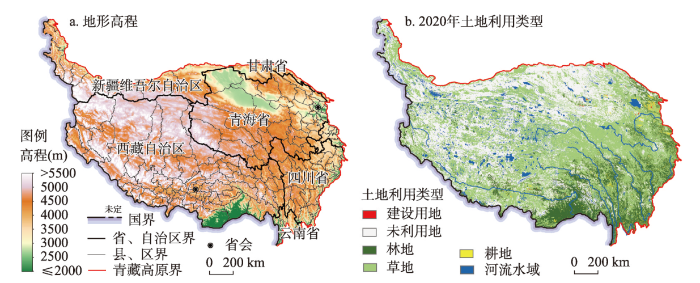
图1
青藏高原地形高程与2020年土地利用类型空间分布
注:基于自然资源部标准地图服务网站GS(2022)4312号标准地图制作,底图边界无修改,下同。
Fig. 1
Topographic elevation and spatial distribution of land use types on the Qinghai-Tibet Plateau in 2020
3 研究方法与数据
3.1 建设用地适宜性评价模型
3.1.1 评价模型与关键参数
尽管建设用地适宜性受到地质、水文、气候、地形、自然灾害和社会经济条件等诸多因素的影响[41],但建设用地适宜性可归结为人体生理适宜性和开展建设活动的便利与难易程度两个基本方面,尤其是在青藏高原,高海拔带来的生理不适宜是建设活动的直接限制因素。徐勇等[37]构建的建设用地适宜性评价方法模型采用空气密度参数和坡地适建系数两个指标,其中空气密度参数由不同海拔高度上的标准化空气密度值与地形高程的一元一次函数拟合关系式计算得出,反映人体在不同海拔高度上的生理适宜性;坡地适建系数由坡地梯级化后实际建设用地面积与坡地垂直投影面积的比值与地形坡度的一元二次函数拟合关系式计算得出,反映不同地形坡度下开展建设活动的难易程度和成本高低,具体原理和测算方法见参考文献[42]。空气密度参数和坡地适建系数的乘积用于定量表达建设用地适宜性指数,公式为:
式中:
3.1.2 高程与坡度分级
合理的地形高程和坡度分级是开展建设用地适宜性评价的前提和基础。根据不同海拔高度上人体生理反应的强弱差异,国际上通行以小于1500 m、1500~2500 m、2500~3500 m、3500~5800 m和大于5800 m将海拔高度划分为低海拔、中等度高海拔、高海拔、极高海拔和极端海拔5个等级[43]。现代医学研究也表明,2500 m基本对应慢性高山病发生的海拔下限,海拔2500 m以下发生高山病的概率很小[44]。海拔3000 m以上,人体机能开始受到慢性高山病的明显影响,并随着海拔的升高而增强,但高海拔适应过程(High Altitude Acclimatization)能够有效缓解其症状[43]。海拔4000 m以上患高原肺水肿和高原脑水肿等急性高山病的概率显著增加[45]。尽管人类永久性聚居点所处的最高海拔可能超过5000 m[46],但就青藏高原而言,县城等规模性人类聚居点的最高海拔多在4500 m左右。
根据不同地形坡度下开展建设活动的难易程度和成本高低,通常以小于3°、3°~8°、8°~15°、15°~25°和大于25°将坡度划分为5个等级,在资源环境承载力评价[32⇓-34]、主体功能区规划[36]、“双评价”[35]和后备适宜建设用地评价[47]等建设用地适宜性评价工作中得到广泛应用(表1)。坡度在3°以下与平地无异,最适宜开展规模性建设活动;坡度在3°~8°之间开展建设活动会受到少量的地形限制;坡度在8°~15°之间开展建设活动的难度和成本显著增加,但坡地改造等工程措施能够降低地形限制的影响;坡度在15°以上已不适宜开展规模化的建设活动,通过工程措施可以少量布置居住用地;坡度在25°以上开展建设活动的工程难度很高,同时面临较大的水土流失风险,不宜作为建设用地[42]。
表1 现有建设用地适宜性评价实践的地形高程和坡度等级划分原则
Tab. 1
| 类型 | 高程分级阈值(m) | 坡度分级阈值(°) |
|---|---|---|
| 灾后重建资源环境承载力评价 | 800、1200、1600、2000、2500、3000 | 3、5、8、10、15、25、30 |
| 主体功能区规划 | 500、1000、2000、3000 | 3、8、15、25 |
| 国土空间规划“双评价” | 1000、2000、3000、4000 | 3、8、15、25 |
| 后备适宜建设用地评价 | 500、1000、2000、3000 | 3、8、15、25 |
参考现有工作对地形高程和坡度的分级分类原则,将人类活动的生理适宜性以及开展建设活动的便利和难易程度关键阈值映射到高程和坡度分级中,同时兼顾模型计算效率和分级对等,以2000 m、2500 m、3000 m、3500 m、4000 m、4500 m和5000 m为间隔将青藏高原地形高程划分为8级,以3°、5°、8°、12°、15°、20°和25°为间隔将地形坡度划分为8级,在此基础上开展建设用地适宜性评价[48]。
3.2 实际建设用地适应性分析指标
3.2.1 实际建设用地适应性指数
实际建设用地适应性通过分析实际建设用地在不同适宜性等级中的分布状况,反映时间维度下实际建设用地扩张对建设用地适宜空间分布的响应过程。适应性越高,表明区域实际建设用地与建设用地适宜空间分布的适配程度越高,冲突性越低。由于建设用地适宜、较适宜和一般适宜等级能够较好支撑建设活动的开展,定义实际建设用地适应性指数为县级单元内处于建设用地适宜、较适宜和一般适宜等级中的实际建设用地面积与建设用地总面积的比值,公式为:
式中:
3.2.2 实际建设用地的垂直梯度指数
式中:
3.3 后备适宜建设用地潜力
式中:
3.4 数据来源与处理
本文使用的数据主要包括地形、土地利用和行政区划数据等。地形高程采用NASADEM数字高程模型,空间分辨率约为1弧秒(30 m),将其重采样为100 m,实验证明建设用地适宜性评价的适宜栅格精度为100 m[37];地形坡度基于NASADEM计算得到。垂直方向上不同高程对应的空气密度值来源于国际标准大气模型[54]。土地利用数据使用资源环境科学数据注册与出版系统(
4 结果分析
4.1 建设用地适宜性评价结果
将青藏高原地形高程和坡度进行空间叠加,分别输入对应高程和坡度分级的空气密度参数
图2
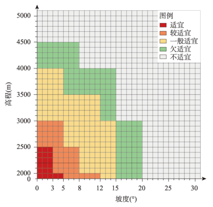
图2
建设用地适宜性等级与高程和坡度的对应关系
Fig. 2
Relationship between the classes of construction land suitability and elevation and slope
图3
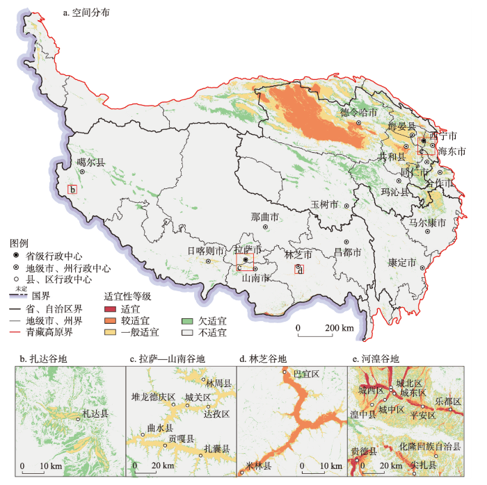
图3
青藏高原建设用地适宜性等级空间分布
Fig. 3
Spatial distribution of construction land suitability classes on the Qinghai-Tibet Plateau
表2 青藏高原建设用地适宜性等级面积
Tab. 2
| 区域 | 适宜等级 | 较适宜等级 | 一般适宜等级 | 欠适宜等级 | 不适宜等级 | 总面积 (104 km2) | |||||||||
|---|---|---|---|---|---|---|---|---|---|---|---|---|---|---|---|
| 面积 (104 km2) | 比例 (%) | 面积 (104 km2) | 比例 (%) | 面积 (104 km2) | 比例 (%) | 面积 (104 km2) | 比例 (%) | 面积 (104 km2) | 比例 (%) | ||||||
| 西藏 | 0.21 | 0.17 | 0.43 | 0.36 | 1.21 | 1.00 | 4.80 | 3.99 | 113.57 | 94.47 | 120.21 | ||||
| 青海 | 0.10 | 0.14 | 9.36 | 13.47 | 9.79 | 14.09 | 11.29 | 16.24 | 38.95 | 56.06 | 69.48 | ||||
| 四川 | 0.01 | 0.04 | 0.05 | 0.19 | 1.43 | 5.61 | 2.73 | 10.70 | 21.25 | 83.45 | 25.47 | ||||
| 甘肃 | 0.00 | 0.04 | 0.36 | 3.81 | 2.71 | 28.99 | 1.68 | 17.95 | 4.60 | 49.20 | 9.35 | ||||
| 云南 | 0.01 | 0.17 | 0.03 | 0.75 | 0.19 | 5.75 | 0.30 | 8.85 | 2.86 | 84.48 | 3.39 | ||||
| 新疆 | 0.01 | 0.02 | 0.20 | 0.66 | 2.73 | 9.02 | 3.34 | 11.00 | 24.05 | 79.31 | 30.33 | ||||
| 青藏高原 | 0.33 | 0.13 | 10.42 | 4.04 | 18.06 | 7.00 | 24.12 | 9.34 | 205.29 | 79.50 | 258.23 | ||||
(1)建设用地适宜等级主要分布在西藏东南部的高山峡谷区和青海河湟谷地。西藏的适宜等级面积为2047.22 km²,占西藏土地总面积0.17%,分布在西藏东南部山南市和林芝市错那县、墨脱县和察隅县等的山间河谷平地;该地区海拔在2000 m以下,水分、热量和氧气含量充足,但山高谷深,地表起伏剧烈,适宜等级用地极其破碎。青海的适宜等级面积为979.21 km²,占青海土地总面积0.14%,主要分布在西宁市和海东市的湟水谷地和黄河谷地。
(2)建设用地较适宜等级主要分布在柴达木盆地、河湟谷地和藏南谷地的二级支流河谷地区。青海省海西州的柴达木盆地是青藏高原建设用地较适宜等级最大的集中连片区,面积达8.85万km²,西宁市、海东市和海南州的共和盆地、黄河谷地和湟水谷地的较适宜等级面积合计4498.48 km²,青海省较适宜等级占土地总面积13.47%。西藏的较适宜等级面积仅次于青海省,面积为4321.4 km²,占西藏土地总面积0.36%,主要分布在藏东南林芝市和山南市错那县的雅鲁藏布江干流谷地及其二级支流河谷地区。
(3)建设用地一般适宜等级分布范围较为广泛,其中青海的一般适宜等级面积达9.79万km²,占青海土地总面积14.09%,主要分布在柴达木盆地及其与祁连山和昆仑山区的山间过渡地带、祁连山区的山间谷地、青海湖盆地、共和盆地以及河湟谷地等地区。甘肃的一般适宜等级面积2.71万km²,占甘肃土地总面积28.99%,主要分布在祁连山区和甘南山区的山间宽谷地区。新疆的一般适宜等级面积2.73万km²,占新疆土地总面积9.02%,主要分布在巴音郭楞州的阿尔金山和昆仑山区山间宽谷地区。四川的一般适宜等级面积1.43万km²,占四川土地总面积5.61%,主要分布在阿坝州的松潘高原地区以及横断山区山间沟谷地带。西藏的一般适宜等级面积1.21万km²,占西藏土地总面积1.00%,主要分布在日喀则谷地,拉萨—山南谷地和藏东南雅鲁藏布江三级支流河谷。
(4)建设用地欠适宜等级主要分布在青海省海西州的祁连山区、果洛州和玉树州的青南高原、新疆巴音郭楞州的昆仑山区、西藏阿里地区的冈底斯山、藏北高原、日喀则市的喜马拉雅山区以及川西高山峡谷地区等的山间谷地。青海的欠适宜等级面积最大,西藏和新疆次之,分别为11.29万km²、4.80万km²和3.34万km²,分别占各自省区土地总面积16.24%、3.99%和11.00%。建设用地不适宜等级面积最大,分布在青藏高原全域,其中藏北—青南高原、帕米尔高原和昆仑山区以建设用地不适宜为主。
4.2 实际建设用地对适宜性评价结果的适应性
1990—2020年青藏高原实际建设用地总面积分别为1228.84 km²、1340.32 km²、2110.94 km²和2633.48 km²,分别占青藏高原土地总面积的0.05%、0.05%、0.08%和0.10%,青藏高原建设用地总体呈不断增长趋势,2000年后明显加快。将4个时间点的实际建设用地与适宜性评价结果进行空间叠加后发现,实际建设用地对建设用地适宜空间是高度适应的。1990—2020年处于适宜、较适宜和一般适宜等级中的建设用地占比分别为85.16%、85.93%、85.18%和78.01%。1990—2010年的实际建设用地适应性总体稳定在85%左右,但2020年较2010年显著下降,表明近年来欠适宜和不适宜等级中的实际建设用地比例升高,建设活动正加速向建设用地欠适宜和不适宜等级区域扩张(表3)。
表3 1990—2020年青藏高原不同适宜性等级中的实际建设用地面积
Tab. 3
| 年份 | 适宜等级 | 较适宜等级 | 一般适宜等级 | 欠适宜等级 | 不适宜等级 | 建设用地 总面积(km²) | 总体适应性(%) | |||||||||
|---|---|---|---|---|---|---|---|---|---|---|---|---|---|---|---|---|
| 面积 (km²) | 比例 (%) | 面积 (km²) | 比例 (%) | 面积 (km²) | 比例 (%) | 面积 (km²) | 比例 (%) | 面积 (km²) | 比例 (%) | |||||||
| 1990 | 148.48 | 12.08 | 434.33 | 35.34 | 463.63 | 37.73 | 97.23 | 7.91 | 85.16 | 6.93 | 1228.84 | 85.16 | ||||
| 2000 | 159.10 | 11.87 | 490.22 | 36.57 | 502.38 | 37.48 | 100.08 | 7.47 | 88.54 | 6.61 | 1340.32 | 85.93 | ||||
| 2010 | 200.10 | 9.48 | 949.38 | 44.97 | 648.73 | 30.73 | 170.52 | 8.08 | 142.21 | 6.74 | 2110.94 | 85.18 | ||||
| 2020 | 240.30 | 9.12 | 826.47 | 31.38 | 987.72 | 37.51 | 324.09 | 12.31 | 254.90 | 9.68 | 2633.48 | 78.01 | ||||
1990—2020年实际建设用地适应性表现出显著的空间异质性,但其空间格局变化总体保持稳定(图4)。实际建设用地适应性指数在80%以上的高适应性区县数量约占1/3,主要分布在阿尔金山—祁连山区、柴达木盆地、河湟谷地、甘南山区、松潘高原、西藏“一江两河”地区以及藏东南林芝谷地等地区,这些区域是人类活动的主要承载地区,建设用地主要分布在建设条件较好的盆地与河谷地带,与适宜性评价结果具有高度的空间耦合性。川藏高山峡谷区的实际建设用地适应性空间差异极大,表现为较高、中等和较低等级交错分布,这与该区域建设用地主要受到地形起伏的强烈限制有关,适宜开展建设活动的区域主要分布在深切河谷底部的冲积平地和海拔相对较低的夷平面地貌类型区,而实际建设用地更多分布在深切河谷两侧的大坡度山地,其对适宜性评价结果的适应性较低。藏北—青南高原、冈底斯山—念青唐古拉山区以及喜马拉雅山区的实际建设用地总体表现为低适应性,适应性指数低于20%的区县数量约占青藏高原区县总数的1/3,表明该区域实际建设用地主要分布在建设用地欠适宜或不适宜等级区域中。
图4
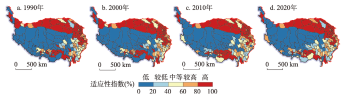
图4
1990—2020年青藏高原实际建设用地适应性指数空间分布
Fig. 4
Spatial distribution of existing construction land adaptability index on the Qinghai-Tibet Plateau, 1990-2020
4.3 实际建设用地对适宜性评价结果低适应的限制因素
1990—2020年青藏高原处于建设用地欠适宜和不适宜等级中的实际建设用地面积分别为182.39 km²、188.62 km²、312.74 km²和578.99 km²,分别占实际建设用地总面积的14.84%、14.07%、14.82%和21.99%,对建设用地适宜空间分布特点适应性低的实际建设用地呈不断增加趋势,2010年以后其扩张趋势明显增强(表4)。从细分用地类型来看,处于欠适宜和不适宜等级中的实际建设用地以农村居民点用地为主,其他建设用地次之,城镇建设用地的占比最小,表明对适宜性评价结果低适应的实际建设用地主要为农村居民点;从时间维度来看,处于欠适宜和不适宜等级中的农村居民点用地占比不断降低,从1990年的78%下降到2020年的41.46%,而城镇建设用地和其他建设用地的占比不断升高,分别从1990年的8.31%和13.17%上升到2020年的19.41%和39.13%,表明农村居民点用地虽然占据主要部分,但其时空格局相对稳定,而城镇建成区、工矿用地尤其交通运输用地等不断向更大坡度和更高海拔的区域扩张,且速率不断加快,也反映了青藏高原快速推进的城市化和工业化进程造成更多的建设用地突破适宜空间,其实际建设用地的低适应程度不断提高。
表4 1990—2020年青藏高原处于欠适宜和不适宜等级中的实际建设用地面积
Tab. 4
| 年份 | 欠适宜等级 | 不适宜等级 | 建设用地 面积(km²) | |||||||||||
|---|---|---|---|---|---|---|---|---|---|---|---|---|---|---|
| 城镇建设用地 | 农村居民点用地 | 其他建设用地 | 城镇建设用地 | 农村居民点用地 | 其他建设用地 | |||||||||
| 面积 (km²) | 比例 (%) | 面积 (km²) | 比例 (%) | 面积 (km²) | 比例 (%) | 面积 (km²) | 比例 (%) | 面积 (km²) | 比例 (%) | 面积 (km²) | 比例 (%) | |||
| 1990 | 8.16 | 4.48 | 76.58 | 41.99 | 12.48 | 6.84 | 6.99 | 3.83 | 66.64 | 36.54 | 11.54 | 6.32 | 182.39 | |
| 2000 | 9.59 | 5.08 | 78.01 | 41.36 | 12.49 | 6.62 | 7.96 | 4.22 | 68.52 | 36.32 | 12.06 | 6.39 | 188.62 | |
| 2010 | 42.51 | 13.59 | 97.05 | 31.03 | 30.96 | 9.90 | 23.00 | 7.35 | 96.06 | 30.72 | 23.15 | 7.40 | 312.74 | |
| 2020 | 75.10 | 12.97 | 123.25 | 21.29 | 125.75 | 21.72 | 37.26 | 6.44 | 116.83 | 20.18 | 100.81 | 17.41 | 578.99 | |
测算处于建设用地欠适宜和不适宜等级中的实际建设用地垂直梯度指数时,将高程和坡度梯度指数按0.1%、0.2%、0.5%和1%为阈值划分为低、较低、中等、较高和高5个等级,分析实际建设用地受高程和坡度限制的作用大小及其时空分布格局(图5)。1990—2020年青藏高原实际建设用地高程和坡度梯度指数大小及其空间分布范围均随时间的推移而逐渐增强。高程梯度指数中等水平及以上的区县数量由1990年的85个,占区县总数的41.87%,到2020年的105个,占比上升到51.72%;其中高程梯度指数高值区时空格局较为稳定,主要分布在青南高原的玉树州和果洛州,零散分布在祁连山区和川西横断山区等区域,而中等和较高水平区县由川西横断山区、祁连山区以及西藏“一江两河”周边区域向藏北高原、冈底斯山区以及喜马拉雅山区等高海拔地区扩张的趋势明显。坡度梯度指数中等水平及以上的区县数量由1990年的83个上升到2020年的105个,占比从40.89%上升到49.75%;其空间范围也由青南高原、川西横断山区、祁连山区、河湟谷地和甘南山区等区域向藏北高原、念青唐古拉山区和藏东南喜马拉雅山区等区域扩张,但其扩张趋势显著弱于高程梯度指数。总体来看,青南高原、川西横断山区和祁连山区的实际建设用地受到高程和坡度的双重限制,表明这些区域实际建设用地对适宜性评价结果低适应的原因来自于高海拔和大坡度两个方面;藏北高原、冈底斯山区和喜马拉雅山区的实际建设用地对适宜性评价结果低适应的原因主要为高海拔的强烈限制,而坡度的贡献程度相对较低。
图5
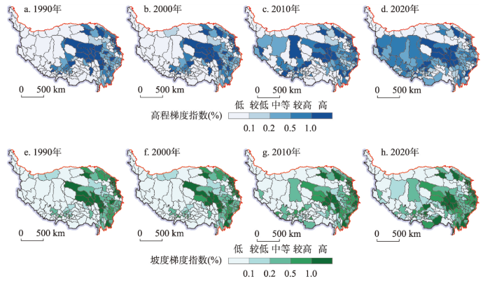
图5
1990—2020年青藏高原实际建设用地高程和坡度梯度指数空间分布
Fig. 5
Spatial distribution of elevation and slope vertical gradient of existing construction land on the Qinghai-Tibet Plateau, 1990-2020
4.4 后备适宜建设用地潜力
使用2020年的土地利用数据和县级单元常住人口数据测算青藏高原后备适宜建设用地潜力和县级单元人均潜力面积(图6、表5)。青藏高原后备适宜建设用地面积为124143.86 km²,占青藏高原总面积的4.81%,其中适宜、较适宜和一般适宜等级面积分别为38.77 km²、60376.56 km²和63728.53 km²,分别占后备适宜建设用地总面积的0.03%、48.63%和51.33%,青藏高原潜在可开发利用的建设用地以一般适宜和较适宜等级为主,人均后备适宜建设用地面积9928 m²/人。从空间分布来看,后备适宜建设用地主要分布在青海省,面积达95947 km²,占后备适宜建设用地总面积的77.29%,人均面积达到17143 m²/人;柴达木盆地的后备适宜建设用地呈现空间上的集中连片,人均面积在50000 m²/人以上,后备适宜建设用地资源十分丰富,可大力开展光伏发电和风力发电等清洁能源建设;共和盆地后备适宜建设用地资源较为丰富,共和县的后备适宜建设用地面积为2226.69 km²,人均面积达到16691 m²/人,同时工农业基础较好,在进行沙化土地整治和建设引水工程之后可作为三江源国家公园生态移民搬迁的重要安置地。西藏的后备适宜建设用地面积仅有464.50 km²,人均面积仅为130 m²/人,主要零星分布在藏东南的山间谷地以及山南雅鲁藏布江谷地,可开发利用的后备适宜建设用地资源十分缺乏;其中雅鲁藏布江山南宽谷段可开发利用条件较好,在解决沙化土地整治和配套引水工程的条件下可满足藏北高原生态移民安置的需求。
图6
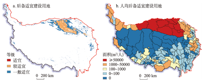
图6
2020年青藏高原后备适宜建设用地与人均面积空间分布
Fig. 6
Spatial distribution of reserve suitable construction land and area per capita on the Qinghai-Tibet Plateau in 2020
表5 2020年青藏高原后备适宜建设用地等级面积与人均面积
Tab. 5
| 区域 | 适宜等级 | 较适宜等级 | 一般适宜等级 | 后备适宜建设 用地面积(km²) | 人均后备适宜建设 用地面积(m²/人) | |||||
|---|---|---|---|---|---|---|---|---|---|---|
| 面积(km²) | 比例(%) | 面积(km²) | 比例(%) | 面积(km²) | 比例(%) | |||||
| 西藏 | 21.92 | 4.72 | 10.07 | 2.17 | 432.52 | 93.11 | 464.50 | 130 | ||
| 青海 | 1.60 | 0.00 | 57430.37 | 59.86 | 38515.03 | 40.14 | 95947.00 | 17143 | ||
| 四川 | 0.17 | 0.01 | 1.77 | 0.09 | 1863.58 | 99.90 | 1865.52 | 925 | ||
| 甘肃 | 2.25 | 0.02 | 2290.03 | 19.57 | 9412.40 | 80.42 | 11704.69 | 18593 | ||
| 云南 | 0.15 | 0.79 | 0.61 | 3.25 | 17.94 | 95.96 | 18.69 | 39 | ||
| 新疆 | 12.68 | 0.09 | 643.72 | 4.55 | 13487.06 | 95.36 | 14143.46 | 69146 | ||
| 青藏高原 | 38.77 | 0.03 | 60376.56 | 48.63 | 63728.53 | 51.33 | 124143.86 | 9928 | ||
5 讨论
5.1 与已有研究对比
根据《主体功能区划技术规程》测算得到青藏高原可利用土地资源等级类型[36],根据《资源环境承载能力和国土空间开发适宜性评价方法指南》测算得到青藏高原城镇建设功能指向的土地资源等级类型如图7。结果发现,在不使用其他因素修正的情况下,基于主体功能区划测算方法的可利用与不可利用土地资源类型面积分别为70.65万km²和188.18万km²,可利用类型面积明显偏大,占青藏高原总面积的27.33%,藏北—青南高原的大片高海拔区域被划分为可利用土地类型,这些区域明显是不适宜开展永久性人类活动的。基于“双评价”方法测算的城镇土地资源评价结果优于主体功能区划,高、较高、中等、较低和低等级面积分别为9.55万km²、11.69万km²、46.85万km²、33.57万km²和157.16万km²,高和较高两个等级的空间分布与本文的评价结果相似度较高,但中等等级面积较大,占青藏高原总面积的18.12%,同样存在不适宜人类活动的藏北—青南高原等高海拔地区被划分为中等和较低等级。总的来看,主体功能区划中的土地资源可利用类型、“双评价”中的土地资源中等和较高等级均存在高估的情况,其原因在于二者的评价方法和框架主要面向中国中东部的低海拔地区,以坡度作为判断建设用地适宜性的主要限制因素,海拔高程的重要程度较低,而这在青藏高原地区是不适用的。3种评价方法的实测数据验证了主体功能区规划和“双评价”中的建设用地适宜性评价方法在青藏高原高海拔地区存在机理性缺陷[37],也证明了本文使用的评价方法更能反映青藏高原的实际情况。在青藏高原相关省区开展国土空间规划实践要重点关注海拔高程对土地资源评价结果造成的误差影响。
图7
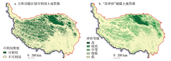
图7
青藏高原主体功能区划与“双评价”的建设用地适宜性评价结果
Fig. 7
Assessment results of construction land suitability in Major Function Zoning and Double Evaluations on the Qinghai-Tibet Plateau
5.2 关于本文评价方法应用的补充说明
本文得出的青藏高原建设用地适宜性是从土地资源角度开展的基础性评价,其适用范围包括城镇村建设用地、工业建设用地以及光伏电厂和风能电厂建设选址等,在实际应用中还需根据用地类型的不同综合考虑使用可利用水资源量和用水条件,地质环境稳定性等工程地质条件以及滑坡、泥石流等地质次生灾害等多种要素对适宜性评价结果进行修订。在中小尺度区域的应用中还可进一步提高分析精度,如在高山峡谷区采用更高分辨率的地形高程数据和更精细的高程坡度分级等。需要注意的是,限于多源土地利用数据的分类和精度不一致,使用不同来源的土地利用数据测算后备适宜建设用地潜力的结果也会有所差异,本文的测算结果可为后续研究提供有益参考;在实际应用中需根据分析尺度和精度要求选取基础数据,中小尺度区域的评价宜选用自然资源部门的土地利用现状调查矢量数据。
基于建设用地适宜性评价结果对处于高海拔和大坡度地区的建设用地搬迁,还需考虑到佛教寺院等特殊用地和交通运输用地的特殊性。藏传佛教建筑呈现典型的宗山式或山崖式建筑群落风格,其空间分布偏好依山而建,用地的坡度很大,同时其分布海拔也普遍高于通常的城镇村聚居区。交通运输用地由于其用地性质具有特殊性,其受人体生理适宜性和工程建设难易程度的限制弱于城镇村建设用地。因此,在开展生态移民搬迁的实际应用中应结合土地利用调查数据和遥感影像进行综合判定,合理扣除特殊用地和交通运输用地。
6 结论与政策建议
6.1 主要结论
本文测算和划分了青藏高原建设用地适宜性等级,分析了1990—2020年实际建设用地对适宜性评价结果的适应性,解析了低适应性实际建设用地的时空差异及其垂直梯度变化特征,测算了后备适宜建设用地潜力,主要结论如下:
(1)青藏高原建设用地适宜、较适宜、一般适宜、欠适宜和不适宜等级面积分别为0.33万km²、10.42万km²、18.06万km²、24.12万km²和205.29万km²,分别占土地总面积的0.13%、4.04%、7.00%、9.34%和79.50%。青藏高原建设用地适宜性以不适宜等级为主,能够较好支撑人类活动的适宜、较适宜和一般适宜等级面积仅占总面积的11.16%,主要分布在柴达木盆地、河湟谷地、共和盆地、松潘高原、日喀则谷地、拉萨—山南谷地以及林芝谷地等区域。
(2)实际建设用地适应性指数总体较高且空间差异明显。1990—2020年青藏高原实际建设用地适应性指数分别为85.16%、85.93%、85.18%和78.01%,平均适应性在80%以上,青藏高原实际建设用地对建设用地适宜空间是高度适应的。适应性指数在80%以上的高适应区县数量占比超过1/3,主要分布在阿尔金山—祁连山区、柴达木盆地、河湟谷地、甘南山区、松潘高原、西藏“一江两河”地区(雅鲁藏布江、拉萨河与年楚河)以及藏东南林芝谷地等区域;川藏高山峡谷区的适应性指数总体表现为较高、中等和较低等级交错分布,空间差异较大;藏北—青南高原、冈底斯山—念青唐古拉山区以及喜马拉雅山区的实际建设用地以低适应性为主。
(3)对适宜性评价结果低适应的实际建设用地存在地类差异,其垂直梯度效应具有显著的时空差异性。1990—2020年青藏高原对适宜性评价结果低适应的实际建设用地主要为农村居民点,其他建设用地次之,城镇建设用地的占比最小,但城镇建设用地和其他建设用地的占比随时间快速升高。实际建设用地的高程和坡度梯度指数逐渐增强,空间分布范围不断扩大,青南高原、川西高山峡谷区和祁连山区的实际建设用地受到高程和坡度的双重限制,而藏北高原、冈底斯山区和喜马拉雅山区的主要限制因素为海拔。
(4)青藏高原后备适宜建设用地面积为12.41万km²,占青藏高原总面积的4.81%,以较适宜和一般适宜等级为主,适宜等级面积很小,人均后备适宜建设用地面积为9928 m²/人。柴达木盆地后备适宜建设用地资源最为丰富,能够支撑大规模工矿和清洁能源基础设施建设;共和盆地和山南雅鲁藏布江谷地可分别作为三江源和藏北高原地区生态移民搬迁的优先安置区。
6.2 政策建议
极高海拔和地形起伏剧烈地区的建设用地扩张不仅增加了脆弱人群暴露在高寒缺氧环境下的风险比例,导致区域交通及公共服务基础设施的配置成本显著增加,同时也造成生态环境的破坏和退化,社会经济发展与生态保护的矛盾凸显。为了解决这一难题,西藏自治区于2018年开展了极高海拔地区生态搬迁,将极高海拔地区的人口整体搬迁至更适宜人类生活的雅鲁藏布江沿岸[61]。然而,生态移民搬迁的区域、规模和安置方向等关键问题尚未有一个科学的回答。本文根据实际建设用地适应性和后备适宜建设用地潜力分析结果,提出藏北高原—山南雅江谷地远程移民搬迁、三江源地区—共和盆地远程移民搬迁、川藏高山峡谷区近程搬迁3种生态移民搬迁模式。
藏北高原—山南雅江谷地远程移民搬迁涉及改则县、措勤县、尼玛县、申扎县、班戈县、双湖县、安多县7个县,总人口18.70万人,牧民人口14.30万人;山南雅江谷地在完成土地综合开发、河道整治和水利工程配套的基础上具备7万~9万人的安置潜力。三江源地区—共和盆地远程移民搬迁涉及曲麻莱县、杂多县和治多县,总人口13.64万人,牧民人口5.86万人;共和盆地配合黄河上游水电梯级开发建设引水工程,在解决水资源问题的基础上,具备5万~10万人的安置潜力。川藏高山峡谷区采用“从山上到山下”的近程搬迁模式,将处于高海拔地区和大坡度河谷两侧坡地的人口逐步就近集中搬迁安置在海拔较低且相对平坦开阔的河谷滩地。
参考文献
Agriculture facilitated permanent human occupation of the Tibetan Plateau after 3600 BP
DOI:10.1126/science.1259172
PMID:25593179
[本文引用: 1]

Our understanding of when and how humans adapted to living on the Tibetan Plateau at altitudes above 2000 to 3000 meters has been constrained by a paucity of archaeological data. Here we report data sets from the northeastern Tibetan Plateau indicating that the first villages were established only by 5200 calendar years before the present (cal yr B.P.). Using these data, we tested the hypothesis that a novel agropastoral economy facilitated year-round living at higher altitudes since 3600 cal yr B.P. This successful subsistence strategy facilitated the adaptation of farmers-herders to the challenges of global temperature decline during the late Holocene. Copyright © 2015, American Association for the Advancement of Science.
Human expansion into Asian highlands in the 21st century and its effects
Most intensive human activities occur in lowlands. However, sporadic reports indicate that human activities are expanding in some Asian highlands. Here we investigate the expansions of human activities in highlands and their effects over Asia from 2000 to 2020 by combining earth observation data and socioeconomic data. We find that ∼23% of human activity expansions occur in Asian highlands and ∼76% of these expansions in highlands comes from ecological lands, reaching 95% in Southeast Asia. The expansions of human activities in highlands intensify habitat fragmentation and result in large ecological costs in low and lower-middle income countries, and they also support Asian developments. We estimate that cultivated land net growth in the Asian highlands contributed approximately 54% in preventing the net loss of the total cultivated land. Moreover, the growth of highland artificial surfaces may provide living and working spaces for ∼40 million people. Our findings suggest that highland developments hold dual effects and provide new insight for regional sustainable developments.© 2022. The Author(s).
Mapping human influence intensity in the Tibetan Plateau for conservation of ecological service functions
DOI:10.1016/j.ecoser.2017.10.003 URL [本文引用: 1]
Chronic mountain sickness: Clinical aspects, etiology, management, and treatment
Environmental determinants of Cardiovascular disease
DOI:10.1161/CIRCRESAHA.117.306458
PMID:28684622
[本文引用: 1]
Many features of the environment have been found to exert an important influence on cardiovascular disease (CVD) risk, progression, and severity. Changes in the environment because of migration to different geographic locations, modifications in lifestyle choices, and shifts in social policies and cultural practices alter CVD risk, even in the absence of genetic changes. Nevertheless, the cumulative impact of the environment on CVD risk has been difficult to assess and the mechanisms by which some environment factors influence CVD remain obscure. Human environments are complex, and their natural, social, and personal domains are highly variable because of diversity in human ecosystems, evolutionary histories, social structures, and individual choices. Accumulating evidence supports the notion that ecological features such as the diurnal cycles of light and day, sunlight exposure, seasons, and geographic characteristics of the natural environment such as altitude, latitude, and greenspaces are important determinants of cardiovascular health and CVD risk. In highly developed societies, the influence of the natural environment is moderated by the physical characteristics of the social environments such as the built environment and pollution, as well as by socioeconomic status and social networks. These attributes of the social environment shape lifestyle choices that significantly modify CVD risk. An understanding of how different domains of the environment, individually and collectively, affect CVD risk could lead to a better appraisal of CVD and aid in the development of new preventive and therapeutic strategies to limit the increasingly high global burden of heart disease and stroke.© 2017 American Heart Association, Inc.
Impact of high altitude on Cardiovascular health: Current perspectives
DOI:10.2147/VHRM.S294121
PMID:34135590
[本文引用: 1]
Globally, about 400 million people reside at terrestrial altitudes above 1500 m, and more than 100 million lowlanders visit mountainous areas above 2500 m annually. The interactions between the low barometric pressure and partial pressure of O, climate, individual genetic, lifestyle and socio-economic factors, as well as adaptation and acclimatization processes at high elevations are extremely complex. It is challenging to decipher the effects of these myriad factors on the cardiovascular health in high altitude residents, and even more so in those ascending to high altitudes with or without preexisting diseases. This review aims to interpret epidemiological observations in high-altitude populations; present and discuss cardiovascular responses to acute and subacute high-altitude exposure in general and more specifically in people with preexisting cardiovascular diseases; the relations between cardiovascular pathologies and neurodegenerative diseases at altitude; the effects of high-altitude exercise; and the putative cardioprotective mechanisms of hypobaric hypoxia.© 2021 Mallet et al.
Mortality, morbidity, and risk factors in China and its provinces, 1990-2017: A systematic analysis for the Global Burden of Disease Study 2017
DOI:10.1016/S0140-6736(19)30427-1 URL [本文引用: 1]
Spatial-temporal pattern of poverty-stricken areas and its differential policies for poverty alleviation in China
中国贫困地区时空格局与差别化脱贫政策研究
Special thinking and green development path of urbanization in Qinghai-Tibet Plateau
DOI:10.11821/dlxb202208005
[本文引用: 1]
Urbanization in the Qinghai-Tibet Plateau is a special mission in defending the national security, the national ecological security and the Asian Water Tower. It plays an irreplaceable role in the world, which ensures the realization of modernization, the happiness of all ethnic groups, a stronger ecological security and a more solid national security barrier in this region. This study discusses in detail the special driving force, development path, development goals, development pattern, green development mode and green development path of new urbanization in the Qinghai-Tibet Plateau, which are completely different from the inland areas. It is believed that the urbanization of the Qinghai-Tibet Plateau is a process characterized by low-level development, cultural inheritance, national defence, water tower protection, small agglomeration and large dispersion, social inclusion, and ecological enrichment. It is driven by a single investment, tourists, services, and counterpart support in an alpine and anoxic environment. In the future, the urbanization development thinking in the Qinghai-Tibet Plateau is, firstly, to take the defence of the territory and the border as the guideline to ensure national security, and a sufficient population in the border and rural areas at a fast, stable and appropriate growth rate. By 2035, the permanent population of the plateau will reach 16 million, and the urbanization rate should be 52.5%, which will be stable in the middle stage of urbanization for a long time, and the quality of urbanization will be promoted comprehensively. Secondly, driven by green development, the ability and level of ecological products and ecological services will be continuously improved, highlighting characteristics and folk customs, and promoting cultural diversity and inclusiveness. And we encourage local herdsmen to live in the town and graze in the township so that they can build beautiful cities and towns and advance in-situ urbanization on the plateau. Thirdly, based on the principle of small agglomeration and large dispersion, the pattern of borderland security urbanization is composed of "three circles, four belts and multi-nodes", emphasizing the agglomeration effect of the three circles (Xining metropolitan area, Lhasa metropolitan area, and Qaidam urban circle), four belts (urban belt along the Qinghai-Tibet Railway, urban belt along the Sichuan-Tibet Railway, town belt along the Tangbo Ancient Road, and border town zone), and multi-nodes (multiple important urban nodes, and important border towns). Fourthly, we should guarantee the channel development, including the construction of new infrastructure facilities such as the Qinghai-Tibet high-speed railway, and the building of plateau smart cities, so as to safeguard national security. Finally, taking territorial security as a top priority, we should speed up the reform of the land system in border cities, set up pilot special zones for borderland land reform, and focus on border cities in major national strategic layout and territorial spatial planning.
青藏高原城镇化发展的特殊思路与绿色发展路径
DOI:10.11821/dlxb202208005
[本文引用: 1]
青藏高原城镇化肩负着捍卫国家安全屏障与护卫国家生态安全屏障及“亚洲水塔”的特殊使命,对守护好世界上最后一方净土、确保“地球第三极”同全国一道基本实现现代化、让青藏高原各族人民生活更幸福、使青藏高原生态安全屏障更牢固、使国家安全屏障更坚固都发挥着不可替代的重要作用。本文详细论述了青藏高原新型城镇化与内地截然不同的特殊驱动过程、特殊发展道路、特殊发展目标、特殊发展格局、绿色发展模式与路径,认为青藏高原城镇化是一个在高寒缺氧环境下,由单一投资拉动、游客带动、服务驱动、对口支援等特殊驱动形成的低度开发型、文化传承型、守土固边型、护卫水塔型、小聚大散型、社会包容型、生态富民型城镇化过程。未来发展思路是:以守土固边为先导,保障国家安全,快稳有度,确保边境和农村地区有足量人口,到2035年高原常住人口将达到1600万人,城镇化率宜为52.5%左右,将长期稳定在城镇化发展的中期阶段,全面提升城镇化发展质量;以绿色发展为主导,不断提高生态产品和生态服务能力及水平,突出特色,彰显民风,弘扬文化,住在镇里,牧在乡里,就近就地镇民化,建设高原美丽城市与城镇;以小聚大散为布局原则,聚散有度,在散聚中形成由“三圈四带多节点”构成“星星点灯”式固边型城镇空间格局,突出“三圈”(西宁都市圈、拉萨城市圈和柴达木城镇圈)、“四带”(青藏铁路沿线城镇带、川藏铁路沿线城镇带、唐蕃古道沿线城镇带、边境地区固边城镇带)和“多节点”(多个重要城市节点和重要固边城镇)的集聚效应;以通道建设为保障,超前建设青藏高铁等基础设施,筑牢国家安全保障线,加快引进“新基建”上高原,建设高原智慧城市;加快边境城市土地制度改革,建设边境土地改革试验特区,以国土安全为重,在国家重大战略布局和国土空间规划中优先考虑边境城市。
A Framework for Land Evaluation
Land-use suitability analysis in the United States: Historical development and promising technological achievements
Various methods of spatial analysis are commonly used in land-use plans and site selection studies. A historical overview and discussion of contemporary developments of land-use suitability analysis are presented. The paper begins with an exploration into the early 20th century with the infancy of documented applications of the technique. The article then travels through the 20th century, documenting significant milestones. Concluding with present explorations of advanced technologies such as neural computing and evolutionary programming, this work is meant to serve as a foundation for literature review and a premise for the exploration of new advancements as we enter into the 21st century.
GIS-based land-use suitability analysis: A critical overview
DOI:10.1016/j.progress.2003.09.002 URL [本文引用: 1]
Agricultural land suitability analysis: State-of-the-art and outlooks for integration of climate change analysis
DOI:10.1016/j.agsy.2019.02.013 URL [本文引用: 1]
Land-use suitability analysis for urban development in Beijing
DOI:10.1016/j.jenvman.2014.06.020
PMID:25036557
[本文引用: 1]
Land-use suitability analyses are of considerable use in the planning of mega-cities. An Urban Development Land-use Suitability Mapping (UDLSM) approach has been constructed, based on opportunity and constraint criteria. Two Multi-criteria Evaluation (MCE) methods, the Ideal Point Method (IPM) and Ordered Weighted Averaging (OWA), were used to generate the opportunity map. The protection map was obtained by means of constraint criteria, utilizing the Boolean union operator. A suitability map was then generated by overlaying the opportunity and protection maps. By applying the UDLSM approach to Beijing, its urban development land-use suitability was mapped, and a sensitivity analysis undertaken to examine the robustness of the proposed approach. Indirect validation was achieved by mutual comparisons of suitability maps resulting from the two MCE methods, where the overall agreement of 91% and kappa coefficient of 0.78 indicated that both methods provide very similar spatial land-use suitability distributions. The suitability level decreases from central Beijing to its periphery, and the area classed as suitable amounts to 28% of the total area. Leading attributes of each opportunity factor for suitability were revealed, with 2256 km(2), i.e. 70%, of existing development land being overlaid by suitable areas in Beijing. Conflicting parcels of land were identified by overlaying the resultant map with two previous development blueprints for Beijing. The paper includes several recommendations aimed at improving the long-term urban development plans for Beijing. Copyright © 2014 Elsevier Ltd. All rights reserved.
Urban construction land suitability evaluation based on improved multi-criteria evaluation based on GIS (MCE-GIS): Case of New Hefei City, China
DOI:10.1007/s11769-013-0609-6 URL [本文引用: 1]
Multi-criteria decision analysis for land suitability mapping in a rural area of southern Italy
DOI:10.1016/j.landusepol.2015.05.013 URL [本文引用: 1]
Land suitability evaluation and reconstruction of settlements in the pastoral area of Tibetan Plateau: A case study of Nagqu county in northern Tibet
DOI:10.31497/zrzyxb.20200315
[本文引用: 1]
Taking Nagqu county in the alpine pasture of Tibetan Plateau as a case study, this paper built a land suitability evaluation index system of settlements, assessed the suitability of the land for the layout of settlements and its suitability grade in the study area using self-organizing mapping neural network (SOFM), evaluated the land suitability of current settlements, and further explored the paths of settlement reconstruction. The results showed that: (1) Nagqu county had a low level of land suitability for the layout of settlements. Suitable and sub-suitable areas, scattered in valleys with low elevations and flat terrain, only accounted for 12% of the total land area. Other areas of poorer suitability were relatively concentrated, accounting for 88% of the total land area. There were obvious differences among various townships and towns in the land suitability of settlements. (2) The current settlements of Nagqu county covered an area of 75.94 km<sup>2</sup>, accounting for only 0.47% of the total land area. Areas where the suitability level was generally suitable and above accounted for 86.47%. About 13.53% of settlement area was distributed in hardly suitable, unsuitable, or prohibited construction areas. The layout of settlements in various townships and towns tended towards high-grade suitability areas. The better the environmental conditions, the more reasonable the layout of settlements; and vice versa. Lack of planning guidelines, irrational setting of administrative villages, local identification with specific survival spaces, and worshipping of mountains by Tibetans all contributed to the unreasonable layout of settlements in Nagqu county. (3) Ecomigration, "village-oriented" development in suitable areas, and other promotion factors can be integrated to realize the spatial reconstruction of settlements. Through constructing the central villages and towns system supported by characteristic industries and giving full play to the element diffusion role of the "point-axis" system, restructuring can be promoted to achieve the economic restructuring of settlements. By means of improving the allocation of public service facilities, enhancing the degree of social organization, strengthening the inheritance of Tibetan culture, and promoting the optimization of other functions, the social restructuring of settlements will be accomplished.
青藏高原高寒牧区聚落用地适宜性评价及其重构: 以藏北那曲县为例
DOI:10.31497/zrzyxb.20200315
[本文引用: 1]
本文建立了适用于高寒牧区的聚落布局适宜性评价体系,利用自组织神经网络(SOFM)对青藏高原藏北地区那曲县展开聚落布局适宜性评价,并评估其现状聚落布局的合理性,在此基础上提出其聚落未来重构的思路。结果表明:(1)那曲县对于聚落布局的适宜性整体较低,适宜性水平高于一般适宜的区域零散分布在海拔较低、地势低缓的河谷地区,仅占全县面积的12%。其他适宜性较低的区域占全县面积的88%,分布相对集中。不同乡镇对于聚落布局的适宜性差异显著。(2)那曲县现有的聚落空间占全县总面积的0.47%,为7594 hm<sup>2</sup>,其中分布在一般适宜及以上等级区的面积占聚落总面积的86.47%,而较不适宜、不适宜和禁建区内的聚落占比高达13.53%。那曲县聚落空间布局倾向于较高级别的适宜区,聚落用地适宜性条件较好的乡镇其布局合理性越高。那曲县局部聚落布局不合理的原因包括:缺失空间布局指引、村级行政区划欠佳、藏民对神山的宗教信仰和历史遗存的地域环境认同。(3)聚落的空间重构可推动生态移民、适度“村庄化”等要素的整合来实现。聚落的经济重构要建设由特色产业为基础的村镇系统、充分利用“点—轴”结构的辐射效应等结构要素的重组来实现。聚落的社会重构需要通过合理安排基础设施、增强藏族社会关系组织程度、提倡藏区优秀文化传承等优化功能的措施来实现。
Mined land suitability assessment: A semi-quantitative approach based on a new classification of post-mining land uses
DOI:10.1080/17480930.2021.1949864 URL [本文引用: 1]
A new geographical information system approach based on best worst method and analytic hierarchy process for site suitability and technical potential evaluation for large-scale CSP on-grid plant: An application for Algeria territory
A multi-criteria GIS based model for wind farm site selection using interval type-2 fuzzy analytic hierarchy process: The case study of Nigeria
DOI:10.1016/j.apenergy.2018.07.051 URL [本文引用: 1]
GIS-based multicriteria decision analysis: A survey of the literature
DOI:10.1080/13658810600661508 URL [本文引用: 1]
GIS-based multiple-criteria decision analysis
DOI:10.1111/j.1749-8198.2011.00431.x URL [本文引用: 1]
Suitability evaluation of urban construction land in Pendik district of Istanbul, Turkey
Ordered weighted averaging with fuzzy quantifiers: GIS-based multicriteria evaluation for land-use suitability analysis
DOI:10.1016/j.jag.2006.01.003 URL [本文引用: 1]
Land suitability analysis for the upper Gila River watershed
DOI:10.1016/S0169-2046(00)00093-1 URL [本文引用: 1]
Land-use suitability assessment for urban development using a GIS-based soft computing approach: A case study of Ili Valley, China
The assessment of land suitability for urban development in the anticipated rapid urbanization area from the Belt and Road Initiative: A case study of Nong Khai City, Thailand
Land suitability and urban growth modeling: Development of SLEUTH-suitability
Suitability assessment of urban land use in Dalian, China using PNN and GIS
DOI:10.1007/s11069-020-04500-z [本文引用: 1]
Design of a GIS and multi-criteria based land evaluation procedure for sustainable land-use planning at the regional level
DOI:10.1016/j.agee.2014.10.015 URL [本文引用: 1]
The integrated studies of geography: Coupling of patterns and processes
DOI:10.11821/dlxb201408002
[本文引用: 1]
Geography is a subject which perceptibly reveals integration and regionalism. The integration means that the diversiform subjects in which geography is involved, and that the regionalism of geography is reflected by the regional differentiation. Through the comprehensive study of the interrelationships among the constituent elements of earth system and the relationship between natural and human systems, it helps us understand the variations of the past, present and future of earth system, and grasp the essence of these changes. Pattern helps us to understand the external features of the world and the process is conducive to the understanding of the internal biophysical mechanism of the world. On the basis of field observations and long-term comprehensive surveys, coupling of patterns and processes at different spatiotemporal scales is an effective way to understand and solve the problems in the field of geography. By analysis of the case studies in the Loess Plateau, the methods of coupling the patterns and processes in the integrated research of geography are discussed and explored.
地理学综合研究的途径与方法: 格局与过程耦合
DOI:10.11821/dlxb201408002
[本文引用: 1]
地理学是一门以综合性和区域性见长的学科。地理学的综合性通过要素多样化来体现,区域性则表现为区域分异或区域差异。地理学综合研究是对地球表层各要素的相互作用以及人地关系的研究,帮助我们认识地球表层系统的过去、现状和未来的趋势,把握其变化的脉搏。格局是认识世界的表观,过程是理解事物变化的机理,基于长期的野外观测和综合调查以及模型模拟,对不同时空尺度下的地理格局与过程进行耦合研究,是从机理上理解与解决地理学综合研究的有效途径与方法。文章结合在黄土高原地区的相关研究案例,探讨了将格局与过程耦合研究的地理学综合研究的途径与方法。
Evaluation method and empirical application of human activity suitability of land resources in Qinghai-Tibet Plateau
DOI:10.11821/dlxb202207004
[本文引用: 5]
The existing human activity suitability evaluation of land resources in China has the defects of insufficient theoretical support in terms of basic data accuracy, elevation and slope classification and suitability grade judgement. When it is applied empirically, there are some problems such as excessive evaluation factors, difficulty in obtaining indicator data, and low altitude of applicable regions. In this paper, we constructed a technical evaluation framework applicable to the Qinghai-Tibet Plateau, and established a grid-scale evaluation model for construction land suitability and cultivated land suitability after selecting key parameters that vary with topographic elevation and slope. And then we proposed a generalized algorithm for key parameters such as atmosphere density, air temperature, slope suitability for construction, and soil erosion resistance of sloping cultivated land. With Milin County in southeastern Tibet as an example, the empirical research has been carried out according to the interval of 100 m in elevation and 1° in slope. In addition, grid precisions of 30 m, 50 m, 100 m, 250 m, 500 m, and 1000 m are tested. This article obtains four conclusions: (1) The construction land suitability and cultivated land suitability can be classified into five levels: suitable, relatively suitable, moderately suitable, less suitable, and unsuitable. Under the grid precision of 30 m, the five levels of construction land suitability account for 1.26%, 2.92%, 2.12%, 2.77%, and 90.93%, respectively. Compared with 30 m, the area ratio results of 50 m, 100 m and 250 m have the errors of ±0.34%, ±0.34% and ±1.11%, respectively. Similarly, the area ratio of each level of cultivated land suitability with a 30 m grid precision is 0.72%, 3.07%, 2.62%, 1.35%, and 92.25%, the errors between it and the results under grid precision of 50 m, 100 m, and 250 m are ±0.52%, and the errors of 500 m and 1000 m grid precisions for both construction land suitability and cultivated land suitability are relatively larger than those of the other grid precisions. (2) Current construction lands (i.e., settlements of cities, towns and villages, industrial and mining lands) in the study area are mainly distributed in areas with levels of relatively suitable, suitable, and moderately suitable according to the distribution ratio. Under grid precisions of 30 m, 50 m, and 100 m, the total land areas of these three levels account for 95.96%, 95.96%, and 94.74%, respectively. Current cultivated land and plantation land are distributed in areas with levels of relatively suitable, moderately suitable, and suitable, accounting for more than 96% of different grid precisions. (3) The empirical research shows that evaluation method, quantitative model, and parameter algorithm for evaluating the human activity suitability of land resources in the Qinghai-Tibet Plateau are feasible and applicable. In the actual evaluation, the grid precision should be controlled within 100 m, and the maximum cannot exceed 250 m. (4) This study established a corresponding pedigree between construction land suitability and cultivated land suitability and topographic elevation and slope that can be applied to the Qinghai-Tibet Plateau. Meanwhile, some professional defects are analyzed of available land resources evaluation methods in major function-oriented zoning and "Double Evaluations" of territorial spatial planning in China when applied to the Qinghai-Tibet Plateau.
青藏高原土地资源人类活动适宜性评价方法及实证应用
DOI:10.11821/dlxb202207004
[本文引用: 5]
针对中国现有土地资源人类活动适宜性评价方法存在的问题,搭建了适用于青藏高原的评价流程框架,建立了基于栅格单元的建设用地和耕地适宜性定量评价模型,提出了空气密度、气温、坡地适建、坡耕地土壤抗蚀等关键参数的普适性算法,并以藏东南米林县为例进行了实证研究。结果表明:① 米林县建设用地和耕地适宜性可划分为适宜、较适宜、一般适宜、欠适宜、不适宜5个等级类型,30 m精度建设用地各适宜性等级面积占土地面积比例依次为1.26%、2.92%、2.12%、2.77%和90.93%;50 m、100 m各等级面积较30 m误差±0.34%,250 m误差 ±1.11%,500 m、1000 m误差较大。30 m精度耕地各适宜性等级面积占土地面积比例依次为0.72%、3.07%、2.62%、1.35%和92.25%;50 m、100 m、250 m与30 m误差±0.52%,500 m、1000 m误差较大;② 米林县现状城镇村及工矿用地主要分布在建设用地较适宜、适宜和一般适宜等级类型,30 m精度三者合计占比达95.96%,50 m、100 m占比分别为95.96%和94.74%。现状耕地和种植园用地主要分布在较适宜、一般适宜和适宜等级类型,3种栅格精度下三者合计占比大于96%;③ 业已建立的评价方法、定量模型及参数算法是可行的和适用的,青藏高原建设用地和耕地适宜性评价的适宜栅格精度为100 m,最大不超过250 m;④ 建立了可应用于青藏高原的土地资源建设用地和耕地适宜性等级类型与地形高程及坡度对应谱系。
Suitable evaluation on cultivated land based on Fuzzy weights of evidence method in the Yarlung Zangbo River, Nyangqu River and Lhasa River region, Tibet
DOI:10.11849/zrzyxb.2014.07.015
[本文引用: 1]
Cultivated land suitability evaluation of the plateau is an important prerequisite to promote the planning of regional agricultural development and the construction of food security system. This paper takes cultivated land of 18 counties in the Yarlung Zangbo River, Nyangqu River and Lhasa River (YNL) region of Tibet as the object of evaluation. The fuzzy weight of evidence model is introduced to screen out nine factors included in the four aspects of topography, climate, soil and water conditions as evidence layers, calculate the fuzzy weight of evidence of factor layer, and finally synthesize parameters of all factor layers to calculate posterior probability weight and revise it to format a distribution map of cultivated land suitability. The study shows that: 1) 80.83% of the known suitable points are above moderately suitable level in the grading figure of modified posterior probability, reflecting a high coherency, which indicates that the fuzzy weight of evidence connecting with modified posterior probability can evaluate the suitability of cultivated land scientifically and effectively. 2) Fuzzy weight of evidence model, which is both data-driven and knowledge-driven, can give full play to the prior knowledge and the role of objective laws. It can also increase the intervention of knowledge by the membership function, effectively using the experience of experts, which, to some extent, avoids arbitrariness in selecting indicators and determining the weight in the knowledgedriven method and overcomes the weakness of purely data-driven method. 3) Highly suitable, moderately suitable, generally suitable and unsuitable culti-vated land in the study area cover 213200 hm2 of cultivated land, accounting for 32.03%, 31.94%, 27.19% and 8.84% respectively, which corresponds to the spatial distribution. This can optimize the scale and layout of cultivated land and also can be used in the practice of cultivated area on the plateau to promote the rational utilization and management of cultivated land.
模糊证据权法在西藏一江两河流域耕地适宜性评价中的应用
DOI:10.11849/zrzyxb.2014.07.015
[本文引用: 1]
开展耕地适宜性评价是编制农业发展规划、优化耕地资源配置的基础性工作。文章以西藏一江两河流域18 个县的耕地资源为评价对象,将模糊证据权模型引入到耕地适宜性评价中,通过该方法筛选出地形地貌、气候、土壤和水资源状况等4 个方面的9 个因子作为证据图层,并计算因子图层的模糊证据权重,最后综合各因子图层的证据权重参数得出后验概率并修正形成耕地适宜性分布图。结果表明:①80.83%的适宜样本点处于修正后验概率分级图的中等适宜级别及以上,即已知信息体现出较高的吻合性,表明模糊证据权模型能够科学、有效地评价耕地资源的适宜性;②集知识驱动与数据驱动一体化的模糊证据权模型既能够充分发挥先验知识、客观规律的作用,也可以通过隶属度函数增加知识干预,有效利用专家的丰富经验,在一定程度上克服了知识驱动方法中因子筛选和权重确定主观性强或纯粹数据驱动方法的不足;③研究区21.32×10<sup>4</sup>hm<sup>2</sup>的耕地资源中,高度适宜、中度适宜、一般适宜和不适宜的耕地资源分别占32.03%、31.94%、27.19%和8.84%,对应其空间分布情况,可以优化耕地资源规模与布局,指导高原耕地区农业生产实践,促进耕地资源的合理利用。
Evaluation of arable land suitability based on the suitability function: A case study of the Qinghai-Tibet Plateau
Climate suitability assessment on the Qinghai-Tibet Plateau
Urban planning construction land standard and its revision of climate and topography in China
DOI:10.11821/dlxb202001014
[本文引用: 2]
Urban planning construction land standard is the technical specification for allocating various types of urban construction land scientifically, and is the basis for drawing up and revising the overall urban planning as well. In view of China's current urban planning construction land standard, there are many problems such as the big gap of land use control threshold, the lack of regional differences in climate revision, and ignorance of the topographical and geomorphological factors. To solve these problems, this paper proposed a step-by-step process framework and quantitative calculation method for the establishment and revision of standards in accordance with the principle of "total-structure" control. Through the setting of conditions, a universal basic standard for construction land was established. Then quantitative analysis was made for the relations between each index and the basic standard with the selected key indicators such as urban population size, sunshine spacing coefficient, valley area (intermountain basin) width and terrain slope. Finally we formed a revision standard for climate, topography and geomorphology which is matched with the basic standard. The main results are as follows: (1) The per capita construction land area of 95 m 2/person can be used as the total indicator for the basic standard of urban planning in China. The percentage of corresponding per capita for each type of construction land is 32.5% for residential land, 7.42% for public administration and public service land, 22.5% for industrial land, 17.5% for transport facilities, 12.5% of green land, and 7.58% of other types of land. The results of revision value of urban population scale shows that the impact of population size difference on the per capita construction land is relatively weak. (2) The climate revision results of per capita residential land and per capita construction land in major cities show that the climate revision value varies greatly between northern and southern China. The climate revision value of the per capita area of construction land varies by latitude as follows: the figure for 20° north latitude is 93 m 2/person; the figure for 30° north latitude is 97 m 2/person; the figure for 40° north latitude is 103 m 2/person; and the figure for 50° north latitude is 115 m 2/person. The basic standard value of 95 m 2/person is roughly distributed along the Xiamen - Guilin - Kunming line. (3) The cities located in mountainous areas, hilly valleys or intermontane basins can reduce the allocation of community parks and comprehensive parks when the average width of river valley or intermontane basin is less than 2 km. When the average width of the valley or intermontane basins is between 2 km and 4 km, the allocation of the comprehensive parks can be reduced. The revised results of per capita land for construction use on slopes indicate that the terrain slope has a great impact on the revised value of per capita construction land. The revised value at 3° is 3.68% higher than the baseline value, and the increases of 8°, 15° and 25° are 11.25%, 26.49% and 68.47%, respectively.
中国城市规划建设用地标准及气候和地形地貌修订
DOI:10.11821/dlxb202001014
[本文引用: 2]
城市规划建设用地标准是科学配置城市各类建设用地的技术规范和编制、修订城市总体规划的基础。针对中国现行城市规划建设用地标准存在的用地指标控制阈值高低差距较大、气候修订缺乏地域分异和地形地貌因素缺失等问题,本文按照“总量—结构”控制的建标思路,提出了标准建立、修订的分步式流程框架和定量测算方法,通过条件设定建立了普适性的建设用地基础标准,进而选择城市人口规模、日照间距系数、河谷地(山间盆地)宽度、地形坡度等关键指标,定量分析了各指标与基础标准之间的关系,形成与基础标准配套的气候和地形地貌修订标准。主要研究结果包括:确定了设定条件下适用于全国不同地区的由人均建设用地面积和人均单项用地类型结构控制的建设用地基础标准;按城市人口规模等级对基础标准进行了量化修订;定量测算了人均居住用地面积随日照间距系数变化的情况,提出了按纬度方向变化的人均建设用地气候修订标准;阐释了河谷地(山间盆地)宽度变化与公园绿地的配置,量化分析了地形坡度与人均建设用地面积变化的关系,建立了针对山地、丘陵地区城市规划建设用地的地形地貌修订标准。
Altitude illness
Consensus statement on chronic and subacute high altitude diseases
General introduction to altitude adaptation and mountain sickness
Highest permanent human habitation
Assessing construction land potential and its spatial pattern in China
DOI:10.1016/j.landurbplan.2011.07.013 URL [本文引用: 1]
Evaluation method and empirical application of construction land suitability and arable land suitability in alpine-gorge region of Qinghai-Tibet Plateau: A case study of Nyingchi city
DOI:10.31497/zrzyxb.20230511
[本文引用: 1]
The Qinghai-Tibet Plateau is an important ecological barrier area in China and Asia.Conducting construction land suitability evaluation (CLSE) and arable land suitability evaluation (ALSE) is important for ecological protection, restriction of human activity space in this plateau. However, the application has the defects of existing CLSE and ALSE models and methods in high-altitude areas. In this paper, we constructed CLSE and ALSE models applicable to alpine-gorge region in the Qinghai-Tibet Plateau, as well as proposed the measurement methods of four control parameters: air density, sloping land suitability for construction, air temperature and soil erosion resistance of sloping land. Based on the standard scenarios of elevation-slope classification with an interval of 100 m in elevation and 1° in slope, an empirical application research was carried out in Nyingchi city, the typical area of alpine-gorge region in the Qinghai-Tibet Plateau, and the feasibility was demonstrated of two different elevation-slope classification scenarios for CLSE and ALSE as well. This article obtains four conclusions: (1) Construction land suitability (CLS) and arable land suitability (ALS) in Nyingchi city can be divided into five grade types: suitable, relatively suitable, moderately suitable, less suitable, and unsuitable. The grade type of CLS and ALS is mainly unsuitable in the city, with 87.48% and 87.42% area ratio of unsuitable grade type, 5.58% and 4.58% area ratio of less suitable grade type, and sum area ratio of suitable, relatively suitable, moderately suitable grade types accounted for only 6.94% and 7.60%. (2) The matching degree is high of CLS and ALS with current construction land and arable land under standard scenario in Nyingchi city, with the matching accuracy reaching 93.59% and 90.89%, respectively, among which the matching accuracy in Mainling county, Chagyib district, and Bowo county is above 95%, and the matching accuracy in Gongbo' gyada county, Nang county, and Mêdog county is very low, respectively. (3) The matching accuracy is 93.11% and 91.28% of CLS under scenarios 1 and 2, and its matching error is -0.48% and -2.31% with the standard scenario. The matching accuracy is 91.52% and 91.54% of ALS under scenarios 1 and 2, and its matching error is +0.63% and +0.65% with the standard scenario. The model error is within an acceptable range. (4) Classification schemes with an interval of 500 m in elevation and 3°, 5°, 8°, 12°, 15°, 20°, and 25° in slope are applicable for CLSE and ALSE in alpine-gorge region of the Qinghai-Tibet Plateau.
青藏高原高山峡谷区建设用地和耕地适宜性评价方法及应用: 以林芝市为例
DOI:10.31497/zrzyxb.20230511
[本文引用: 1]
青藏高原是中国乃至亚洲的重要生态屏障区,进行建设用地和耕地适宜性评价对于青藏高原生态保护、严格人类活动空间具有重要意义。针对中国现行建设用地和耕地适宜性评价方法在高海拔地区应用中存在的不足,分别构建了适用于青藏高原高山峡谷区的建设用地和耕地适宜性评价模型,提出了空气密度、坡地适建、气温和土壤抗蚀四个控制参数测算方法;以100 m间隔高程分级和1°间隔坡度分级为基准情景,选择林芝市为典型案例开展实证应用研究,并对两种增大高程和坡度间隔分级情景进行论证。结果表明:(1)林芝市建设用地和耕地适宜性均以不适宜为主体,不适宜区面积占土地总面积比例分别为87.48%和87.42%,欠适宜区比例分别为5.58%和4.58%,适宜、较适宜和一般适宜区的面积之和占比分别仅为6.94%、7.60%;(2)基准情景下建设用地和耕地适宜性评价结果与现状建设用地和耕地的适配效果较好,适配精度分别达到93.59%和90.89%,米林县、巴宜区和波密县的适配精度达到95%以上;(3)情景1和情景2下建设用地适宜性的适配精度与基准情景的误差分别为-0.48%和-2.31%,耕地适宜性的适配精度与基准情景的误差分别为+0.63%和+0.65%,误差处于可接受范围;(4)500 m高程间隔和3°、5°、8°、12°、15°、20°、25°的坡度间隔适用于青藏高原高山峡谷区建设用地和耕地适宜性评价。
Evolution characteristics of slope spectrum and slope-climbing effects of built-up land in China
DOI:10.11821/dlxb202107013
[本文引用: 1]
The changes in the scale and structure of built-up land is the basis for spatial development and planning of the national territory. Previous studies mainly focused on the characteristics and patterns of the horizontal expansion of built-up land, but little attention has been given to the "three-dimensional" gradient characteristics and effects of built-up land (such as slope-climbing). Therefore, based on Google Earth Engine, this study, for the first time as far as we know, uses DEM and land use data to draw built-up land slope spectrums and calculates the average built-up land climbing index (ABCI). The gradient characteristics and laws of the slope climbing of China's built-up land from 1990 to 2018 at the national, regional, provincial, and urban scales are systematically analyzed and the various spatial effects are explored. The results show that: (1) From 1990 to 2018, the area of built-up land with slope angle above 5° in China increased by 1.43 times, and the proportion of the total built-up land area rose from 10.25% to 14.81%. Particularly, the 2010-2015 period witnessed the fastest and largest slope-climbing development of built-up land in China. Moreover, the slope-climbing intensities in the central and western regions are higher than that in other regions. (2) According to the average built-up land climbing index (ABCI) and the upper limited slope angle change (ULSC), the 34 provinces (autonomous regions and municipalities) in China can be divided into three types: high-climbing, low-climbing, and horizontally expanding. Among them, the number of high-climbing provinces accounts for more than 50% of the total. And seven horizontally-expanding provinces present the distribution characteristics of "southeast-northwest" in space. (3) Before 2010, the cities with slope-climbing phenomenon were mainly mountainous cities. However, ethnic minority settlements and low-hill and gentle slope development pilot cities became the main force for the slope-climbing of built-up land after 2010. (4) The slope-climbing of built-up land can reduce the occupation of plain arable land and ecological land by built-up land expansion to a certain extent, and thus alleviate the contradiction between supply and demand of build-up land. However, it is worth noting that development and construction without reasonable plans and bulldozing mountains to build cities driven by real estate can also lead to increased geological disasters and ecological risks.
中国建设用地的坡谱演化规律与爬坡影响
DOI:10.11821/dlxb202107013
[本文引用: 1]
城镇建设用地规模与结构变化是国土空间开发与规划研究的基础。以往相关研究更关注建设用地水平空间扩张格局特征与模式,极少关注建设用地三维梯度上的“爬坡”特征规律与影响。因此,本文基于Google Earth Engine(GEE),并结合高精度地形数据与土地利用数据,在建设用地坡谱概念基础上,首次构建了平均建设用地爬坡指数(ABCI),系统地分析了1990—2018年中国建设用地坡谱在国家、区域、省级和城市4个尺度上的变化特征与规律并深入剖析建设用地爬坡的空间影响。结果显示:① 1990—2018年中国坡度5°以上地区建设用地面积增长了1.43倍,比例由10.25%上升至14.81%。其中2010—2015年是建设用地爬坡发展最迅速与规模最大的时期,且中西部地区建设用地爬坡最为显著。② 依据平均建设用地爬坡指数与上限坡度变化,可将中国34个省(自治区、直辖市)划分为高爬坡型、低爬坡型和水平扩展型3类,其中高爬坡型省份占50%以上,水平扩展型省份仅有7个,在空间上呈现“东南—西北”的两极分布特征。③ 1990—2010年爬坡型城市以山地与丘陵地貌城市为主,2010年后少数民族聚居区及低丘缓坡开发试点城市成为建设用地爬坡的主力。④ 建设用地爬坡在一定程度上能够减少建设用地扩张对平原优质耕地与生态用地的胁迫和侵占,缓解建设用地供需矛盾,但是无规划约束的开发和房地产驱动的“削山造地”则会导致地质灾害和生态环境风险的增加。
Relationship between construction land and slope in rapidly expanding mountain cities: A case study in Guiyang, China
DOI:10.31497/zrzyxb.20220714
[本文引用: 1]
With the rapid urbanization, the land utilization rate in the mountainous areas has been increasing. Therefore, we should deepen our understanding of the construction land expansion in mountain cities, so as to carry out more scientific management of land use in mountainous areas. This paper studied the slope gradient effect of construction land growth in Guiyang, a typical mountain city in Southwest China, using digital elevation model (DEM) and construction land datasets of 2000, 2005, 2010, 2015 and 2020, which was integrated with zonal statistics approaches based on spatial statistics unit of kilometer grid and slope section with one degree interval. Combined with the information of construction land density and slope, we propose a novel method to quantify the spatial pattern of construction land climbing. The research was designed to address three research questions: Is there a synergistic relationship between the area of construction land and the average slope of construction land? What are the distribution and change characteristics of construction land density on the slope gradient? What is the relationship between the density of construction land and the heat of construction land climbing? The results showed that: (1) The total area of construction land is positively correlated with the average slope of construction land, both of which increase gradually across the entire study period. However, the average slope of new construction land gradually becomes steeper among four neighboring periods, while the area of new construction land turns from increasing to decreasing, implying that they are not synchronous. (2) The density of construction land in each period decreased with the increase of slope, no matter in one period or in the other four periods. (3) The density of construction land has a significant impact on the heat of construction land climbing, and this influence increases as the average slope of the background ground rises. This paper suggests that the phenomenon of construction land climbing would promote the intensification and compactness of construction land in mountain cities.
山地城市建设用地增长的坡度梯度效应: 以贵阳市为例
DOI:10.31497/zrzyxb.20220714
[本文引用: 1]
山地城市快速扩张致使其建设用地爬坡现象日趋普遍,深入认识该现象将有助提高山区国土空间管控科学性。以中国西南典型山地城市贵阳为例,利用数字高程模型和2000—2020年五期建设用地数据,构建建设用地密度、建设用地爬坡热度等指标,基于网格单元和坡度区段单元开展统计分析,探究该市建设用地增长的坡度梯度效应。结果表明:(1)建设用地面积的增长总体伴随着建设用地平均坡度的趋陡,各相邻时段新增建设用地面积先增大后减小,但新增建设用地平均坡度却一直在变陡;(2)各时期建设用地的现状密度和新增密度均随坡度上升而减小,在坡度梯度上体现出强烈的“择平而建”效应;(3)建设用地密度对建设用地爬坡热度有显著线性影响,且该影响随着背景地面平均坡度上升而增强。研究认为,建设用地爬坡现象通常更多出现在建设用地加密时期,这有利于促进山地城市实现更为集约紧凑的空间增长。
The pattern of available construction land along the Xijiang River in Guangxi, China
DOI:10.1016/j.landusepol.2014.07.010 URL [本文引用: 1]
Potential of available construction land in the Yangtze River Economic Belt
长江经济带后备适宜建设用地潜力
Evaluation of reserve available land resources based on three types of territorial space: A case study of Jiexiu city in Shanxi province
DOI:10.18306/dlkxjz.2021.02.008
[本文引用: 1]
The spatial distribution of reserve available construction land overlaps with that of reserve available cultivated land in the resources and environmental carrying capacity and territorial development suitability evaluations of current territorial spatial planning. On the basis of elaborating the connotation of relevant concept, this study developed an integrated evaluation method of reserve available land resources, discussed the regional tendency of use of these two types of land, and took Jiexiu City in Shanxi Province as an example. The results are as follows: 1) Reserve available construction land in Jiexiu City had an area of 45.3 km 2, which was 6.1% of the total land area of the city. Its distribution was scattered. The reserve available construction land could be generally divided into three levels: highly suitable, suitable, and less suitable. The corresponding areas were 3.6 km 2, 16.1 km 2, and 25.6 km 2 respectively. The area of reserve available construction land per capita was 0.16 mu. 2) The area of the reserve available cultivated land was 74.1 km 2, which was 10% of the total. The reserve available cultivated land also could be divided into three levels: highly suitable, suitable, and less suitable. The corresponding areas were 21.7 km 2, 26.1 km 2, and 26.3 km 2respectively. The area of reserve available cultivated land per capita was 0.26 mu. There were similar spatial distributions between these two types of land in the study area. The potential of reserve available land resources in Mianshan and Lianfu towns was large, while the potential of the urban area and its surroundings was small. In view of the overlap and difference of spatial distribution between these two types of land, reserve available land resources in the urban area, town centers, and the northern part of the city could be used as construction land preferentially in the future. They should be classified as urban space. Reserve available land resources in the southern areas of Lianfu, Mianshan, Yitang, and Zhanglan towns could be transformed into new cultivated land. They should be classified as agricultural space.
基于“三类”空间的后备可利用土地资源评价研究: 以山西省介休市为例
DOI:10.18306/dlkxjz.2021.02.008
[本文引用: 1]
针对当前国土空间规划“双评价”中存在的后备适宜建设用地与后备适宜耕地在城镇、农业空间分布上的重叠性问题,论文在对2类用地进行概念内涵辨析的基础上,尝试构建后备可利用土地资源集成评价方法,探讨不同类型后备可利用土地资源用途的地域导向,并选取山西省介休市作为案例区进行实证应用研究。结果表明:介休市后备适宜建设用地面积较大(45.3 km <sup>2</sup>),但集中连片趋势不明显。人均后备适宜建设用地面积为0.16亩/人。区域后备适宜耕地面积74.1 km <sup>2</sup>,人均后备适宜耕地面积为0.26亩/人。研究区域2类用地具有相似的空间分布格局,即绵山镇、连福镇等地区后备可利用土地资源潜力较大,而城区及周围地区的潜力较小。针对2类用地的重叠性和差异性,介休市城区、各乡镇中心及北部地区的后备可利用土地资源未来可转化建设用地,即未来应被划归城镇空间。连福、绵山、义棠、张兰等乡镇南部地区未来可转化为新增耕地,即应被划归农业空间。
Spatiotemporal characteristics, patterns and causes of land use changes in China since the late 1980s
DOI:10.11821/dlxb201401001
[本文引用: 1]
Land-Use/land Cover Changes (LUCC) are a direct consequence of human and nature interactions. China's Land Use/cover Datasets (CLUD) were updated regularly at five-year intervals from the late 1980s to the year of 2010 with standard procedures based on Landsat TM/ETM + images. A dynamic zoning method was proposed to analyze major land-use conversions. The spatiotemporal characteristics, differences, and causes of land-use changes at a national scale were then examined. The main findings are summarized as follows: Land-Use Changes (LUC) across China indicated a significant variation in spatial and temporal characteristics in the past 20 years between the 20th and 21st centuries. The amount of cropland change decreased in the south and increased in the north, but the total area remained almost unchanged. The reclaimed cropland was shifted from northeast to northwest. The built-up lands were expanded rapidly, which were mainly distributed in the east and gradually spread out to the midwest. Woodland decreased first and then increased, but desert area was inverted. Grassland continued decreasing. Different spatial patterns of LUC in China were found between the late 20th century and the early 21st century. The original 13 LUC zones were replaced by 15 units with changes of boundaries in some zones. The main spatial characteristics of these changes included (1) an accelerated expansion of built-up land in the Huang-Huai-Hai region, the coastal areas of southeastern China, the midstream area of the Yangtze River, and the Sichuan Basin; (2) the shifted land reclamation in the north from Northeast China and eastern Inner Mongolia to the oasis agricultural areas in Northwest China; (3) the continuous transform from rain-fed farmlands in Northeast China to paddy fields; and (4) the effectiveness of the “Grain-for-Green” project in the southern agricultural-pastoral ecotones of Inner Mongolia, the Loess Plateau, and mountainous areas of southwestern China. In recent two decades, although climate change in the north impacted the change in cropland, policy regulation and economic driving forces were still the primary causes of LUC across China. During the first decade of the 21st century, the anthropogenic factors that drove variations in land-use patterns have shifted the emphasis from one-way land development to both development and conservation. The "dynamic zoning method" was used to analyze changes in the spatial patterns of zoning boundaries, the internal characteristics of zones, and the growth and decrease of units. The results revealed "the pattern of the change process," namely the process of LUC and regional differences in characteristics at different stages. The growth and decrease of zones during this dynamic LUC zoning, variations in unit boundaries, and the characteristics of change intensities between the former and latter decades were examined. The patterns of alternative transformation between the "pattern" and "process" of land use and the reasons for changes in different types and different regions of land use were explored.
20世纪80年代末以来中国土地利用变化的基本特征与空间格局
Remote sensing monitoring data of land use in China
中国多时期土地利用遥感监测数据集(CNLUCC)
Datasets of the boundary and area of the Tibetan Plateau
《论青藏高原范围与面积》一文数据的发表: 青藏高原范围界线与面积地理信息系统数据
