

1 引言
乡村是城市建成区以外的广大乡土地域,是具有特定自然、经济、社会特征和生产、生活、生态、文化等多功能的地域综合体[1-2]。根据人地关系地域系统理论,城市和乡村是在经济、空间、社会、文化等方面存在明显差异,但又相互联系的两个子系统[3]。第二次社会大分工以来,乡村与城市作为人类社会经济发展的两个重要载体,城乡之间的要素流动频率和强度逐渐增加。1978年改革开放以来,中国工业化与城镇化快速发展,乡村地区生产要素非农化、农村主体老弱化、村庄用地空废化、乡村地区贫困化、水土环境污损化等“乡村病”日益凸显[4];城市地区交通拥堵、住房紧张、基础设施与公共服务设施超荷、社会失调、生态环境污染等“城市病”也愈加明显[5]。乡村病与城市病互为病因,阻碍了社会经济的可持续发展,要素从乡村单向流出和城乡要素难以自由流动和平等交换成为“城乡病”产生的主要成因[6]。在工业化与全球化背景下,现代产业体系运转所需的要素数量和结构日趋复杂化,城乡要素的互补性决定了城乡要素流动在当代城乡社会经济活动运行的基础性作用。因此,城乡间要素的自由双向流动成为实现城乡功能互补、城乡融合发展的必要条件[7]。
城乡要素流动思想起源于古典时期Smith的绝对优势理论[8],认为地域间的分工可提高劳动生产率;第二次世界大战结束后,城乡发展与城乡要素流动研究备受关注,但主要集中在单项或几项要素在城乡之间的单向流动。例如经典的基于城市导向的Lewis的二元经济结构理论[9]、Perroux的增长极理论[10]和基于乡村导向的Schultz的传统农业改造理论[11]等。21世纪以来,学者们在城乡要素流动的类型与范畴、特征与机制及其与乡村振兴、城乡融合的相互关系等方面开展了大量研究。城乡要素的类型从基本的劳动力、土地、资本等生产要素逐步拓展到信息、技术、文化等新生产要素[6,12],城乡要素流动的范畴也进一步扩大,城乡之间的产业、产品、公共服务、文化观念等要素流动也被视为广义的“城乡对流”[7]。① 单项要素的流动特征研究包括,运用问卷调查数据或流动人口动态监测调查数据,开展城市群地区城乡人口流动研究[13-14];结合政策梳理和历史资料,研究中国城乡土地要素流动的主要形式和特征[15];基于实地调研,测度微观尺度的城乡资本要素以及商品流动[16-17];利用城乡人口流动调研数据,系统刻画城乡间的生态系统服务流动、生活方式变化等[18-19]。② 多要素流动特征研究包括,运用传统经济学的计量分析,测度人口、资本、技术流动[20];利用地理学的“流空间”理论,测度地域单元间的要素流动[21-22]。③ 要素流动机制研究,通过定性研判和定量识别相结合,阐明要素流动对城乡发展[23]、城乡融合[7,24 -25]和城乡关系调控[3,26]的影响。全球化背景下,社会经济活动对地域的综合影响已逐渐发展为多时空尺度[27-28],不同尺度的城乡要素流动特征研究亟需加强,尤其是基于社会生产全过程视角的城乡要素流动测度研究,可为新时代城乡融合与乡村振兴提供理论支撑。
城乡要素流动通过改善要素在城乡空间的配置,如乡村人口、土地资源流向城市,城市的资本、管理、服务流向乡村,从而提高城乡社会再生产效率,实现城乡发展的等值化,为实现城乡融合和乡村振兴打下基础[29]。为优化城乡要素流动与城乡融合,中国共产党“十九大”提出“乡村振兴”战略,要求建立健全城乡融合发展体制机制和政策体系;“十四五”规划和2035年远景目标纲要指出,建立健全城乡要素平等交换、双向流动政策体系。因此,本文以社会再生产理论为基础,构建了城乡要素的测度方法,基于面板数据开展2013—2020年中国省域城乡要素流动格局与演化过程研究,为明晰城乡要素流动态势,破解城乡发展不平衡与不充分难题,促进乡村振兴与城乡融合提供理论支撑。
2 理论基础
2.1 社会再生产理论
社会再生产理论认为社会再生产由生产、分配、交换、消费4个环节构成[30]。生产和消费互为因果,生产环节伴随着生产要素消费,消费环节伴随着劳动力的再生产;分配和交换会引导要素流动、影响生产效率、消费结构和程度,而生产和消费也会影响分配交换的方式、性质、深度和广度等。
社会再生产过程的正常运转,需要各环节中要素的投入和循环。城市和乡村存在显著的资源禀赋差异,若仅依靠地域内的要素投入的社会再生产,会严重影响社会再生产效率,导致区域内部城乡发展、区际社会经济发展受限[21]。因此,城乡之间以及区际的社会再生产过程对城乡发展具有重要意义。由于本文主要关注社会再生产过程中要素在空间的变化,为方便要素流动测度,将社会再生产理论中的交换和分配环节统称为中介环节,将社会再生产过程简化为生产、中介、消费3个环节。
2.2 城乡要素
根据传统经济学理论,要素仅包括在物质生产过程中投入的土地、资本、劳动力以及技术、专利、信息等资源。本文基于社会再生产理论,将要素范围扩大至生产、中介、消费等环节,将物流、仓储设施与服务,交换分配的媒介场所和农产品、非农消费品等资源均纳入要素范畴。因此,本文中的城乡要素泛指影响城市与乡村一切社会经济活动的实体和非实体资源,划分为生产环节的劳动力、土地、资本等要素,中介环节的公共资源、信息技术、文化等要素,以及消费环节的农产品、非农消费品等要素。此内涵下的城市或乡村要素属性具有可变性,尤其强调要素的空间属性,为方便测度,将要素用于城市的社会再生产过程,则定义为城市要素,反之则为乡村要素。
2.3 城乡要素流动
要素流动是各类生产要素在时间和地域空间上呈现出的数量、质量、位置等变化,基于社会再生产、人地关系地域系统等理论,结合乡村和城市的差异性,将城乡要素流动定义为影响城市与乡村发展的要素变化,流动类型划分为内流动、互流动和区际流动3种类型(图1)。
图1
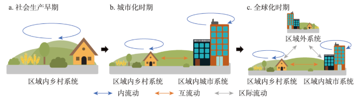
早期社会的城乡地域系统实质上是单一的以乡村社会为特性的乡村地域系统[2]。该阶段的社会再生产以满足生计为目的,要素仅在乡村系统内部低强度、短距离流动(内流动),以满足简单的社会再生产需求。从要素流动的类型来看,社会再生产过程中的生产环节受交通运输条件限制,主要以就地取材的方式进行生产,生产要素的主要类型以劳动力和土地为主,但在空间上无明显流动;中介环节主要为产品的储存、运输、交换等,主要媒介为人力或畜力运输和临时性集市等;消费环节的要素类型主要为初级农产品和手工业品,消费量相对较低。
城市出现以后,社会再生产从满足生计需求逐渐转向财富积累,以满足人类社会更高级的物质和精神需求,社会再生产过程所涉及的要素类型和结构更为复杂。城市或乡村内部的短距离要素流动已无法满足复杂的社会再生产活动,城市与乡村之间的要素流动(互流动)也随着城镇化水平的提升而不断增强。具体来看,生产环节主要呈现出人口、土地、资本从乡村单向流入城市。例如,农村劳动力进入城市从事非农生产,农村土地转为城市建设用地,农业原始积累资本向工商业投资等[7];中介环节的要素类型扩展为交通运输、物流仓储、交易服务等媒介,加速产品与服务流动,医疗、教育、文化等各类公共资源和信息、技术、文化等非物质要素也逐渐成为中介要素,并在城市和乡村之间流动;消费环节中,城乡居民消费的转型升级,促使农产品从农村流向城市、非农产品从城市流向农村,流动强度和流动距离显著高于早期社会阶段。
全球化时期,受现代工业化、信息化影响,区域互动交流日益紧密。远距离的人类活动开始影响区域内的城乡地域系统[2],形成了区际间远程的要素流动(区际流动)。虽然城乡要素流动类型与城市化时期类似,但流动强度更大,流动方向更复杂。生产要素从乡村单向流向城市逐渐转变为动态双向流动,如城市人口返乡创业、驻村工作等人口流动,城市或工矿用地收缩、土地复垦、生态修复等土地流动,城乡之间用于直接投资或伴随着商品、服务的资金流动等[7]。此外,国家尺度下的人口跨省迁移、资源调配(如南水北调、西气东输),全球尺度下的跨国公司投资等活动,均属于生产要素的区际流动;中介要素的区际流动在信息技术以及现代物流交通体系的支撑下,城市、乡村、区际系统中的要素流动壁垒被打破,流动强度显著提高;消费环节的要素流动主要表现为产品的进口与出口,产品流通的类型、数量也显著提升。
图2
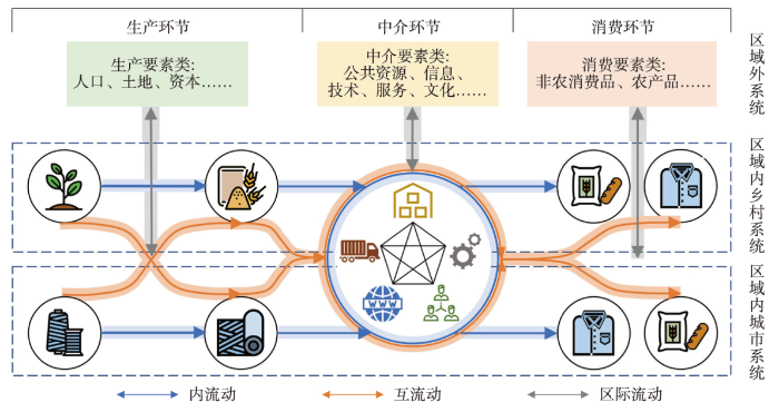
图2
基于社会再生产理论的城乡要素流动分析图
Fig. 2
Analysis diagram of urban-rural factor flow based on the theory of social reproduction
3 方法与数据
3.1 城乡要素流动测度框架
某一区域要素变化主要来源于城市和乡村内部的自然变化、城市和乡村之间的流动、区际间的流动。已有研究通常利用统计数据,直接利用城市要素变化量(ΔU)和乡村要素变化量(ΔR)用于城乡要素流动研究[12],无法体现要素的“内流动、互流动、区际流动”特征。因此,本文基于城乡要素类型划分和假设,构建城乡要素区际流动(Inter-regional Flow, IRF)、互流动(Mutual Flow, MF)、内流动(Inner Flow, IF)的测度模型。
假定1:当城乡要素发生区际流动时(区际流动量已知),城市和乡村的区际流动量,由该类城乡要素存量占该区域要素总量的比例计算。
假定2:当要素在区域内的自然变化率已知,则假定该要素在城市与乡村自然变化率等于要素在该区域的自然变化率。
若将互流动的正值定义为要素从乡村流向城市,区际流动的正值定义为区域外系统要素流入,则MF和IRF可表达为:
式中:RMF和UMF分别指要素从乡村流向城市、要素从城市流向乡村;RIRF和UIRF分别指要素从特定区域内的乡村和城市流入到区域外。由于RMF、UMF相对难以直接测度,可以借助统计数据中的∆R、∆U、∆RNG和∆UNG,通过ΔR和ΔU可进行分解:
式中:ΔRNG和ΔUNG分别指乡村和城市内部要素的自然变化。由公式(1)~(4)可以得出MF和IRF的测度公式:
城乡要素内流动(IF)的流动测度较为特殊,当所测度要素在社会再生产过程中一旦投入,则被一次性消耗(如各类消费品),从要素实际参与社会再生产的角度看,城乡要素在系统内的变化量(ΔR、ΔU)可分解为内流动(RIF、UIF)、互流动(RMF、UMF)和区际流动(RIRF、UIRF)3类。根据定义,可得到IF的测度公式:
当所测度要素在社会再生产过程中投入后,可被多次利用(如人口、土地、资本等生产要素,物流、仓储等中介要素),则要素在子系统内的流动无法简单用城乡要素在系统内的变化量表达。该情况下,需通过其他方法对该类要素的内流动进行测度。考虑已有数据只能测度2013—2020年中国省域部分类型城乡要素内流动,故本文仅对城乡要素互流动和区际流动进行测度分析。
3.2 不同类型要素流动测度
基于数据可获取性、要素类型可代表性原则,本文以城乡要素流动测度框架为基础,选取生产环节的人口、土地、资本要素,中介环节的公共资源、技术要素,消费环节的农产品、非农消费品要素,在省域尺度进行测度。
3.2.1 人口流动
人口流动包括自然变化、互流动和区际流动。其中,自然变化指省域内城乡人口的自然增长,互流动指人口在省域内城乡之间的迁移,外流动指跨省域的城乡人口迁移。因此,t年份人口区际流动PIRFt与城乡人口互流动PMFt的测算公式如下:
式中:Pt、RPt、UPt分别表示t年度本省总人口、乡村人口、城镇人口数;Pt-1、RPt-1、UPt-1则代表t-1年度人口数;NPGRt表示t年度本省人口自然增长率。
3.2.2 资本流动
式中:Rcfst、Ucfst分别表示t年度省域内乡村、城镇的资本变化量;SFCt、RSFCt、USFCt分别表示t年度全省、省域内乡村、城镇的固定资本存量。
3.2.3 农产品流动
农产品包括自然变化、区际流动和乡村单向互流动。其中,自然变化指省域内农产品的生产,乡村单向互流动指本省农产品从乡村流向城市,区际流动指本省农产品流向省外,或外省农产品流向本省。因此,t年份农产品区际间流动APIRFt和互流动APMFt的测度公式为:
式中:APSij表示i年度第j种农产品(1=粮食,2=肉类)在本省的产量;RAPDij和UAPDij分别表示i年度第j种农产品在本省乡村、本省城市的需求量(消费量)。
3.2.4 其他要素流动
土地要素、公共资源要素和非农消费品要素均只存在互流动方式,其中,土地要素的互流动实质为区域土地利用类型在农业用地和城市建设用地之间的转化,公共资源要素的互流动实质为省域内城市公共资源向农村地区的倾斜配置,非农消费品的互流动实质为本省非农消费品从城市流向乡村。因此,可直接将城市要素变化量或乡村要素变化量作为土地要素、公共资源要素和非农消费品要素互流动的量。其中,土地要素互流动的量可用城市建成区面积的变化量表示,城乡公共资源配置可用乡村千人医疗床位数[12]表示,非农消费品互流动可用农村居民家庭生活消费支出与食品消费支出的总差额代替。技术要素的流动主要以区际间的流动为主。根据已有研究,外商直接投资与技术流动存在显著正效应[25],因此用外商直接投资代表技术要素的区际流动。
3.3 城乡要素流动强度
基于不同类型要素流动量的城乡要素流动强度评价,可为对比分析不同属性的城乡要素流动特征提供重要支撑。基于已有研究方法[22],将各类要素的流动量取绝对值后进行归一化处理,采用熵权法确定权重,通过加权求和分别得到生产、中介、消费环节的要素流动强度以及综合强度。
3.4 数据来源
研究数据主要包括人口、土地、资本、外商直接投资、公共资源、农产品、非农消费品等。主要来源于2012—2020年《中国统计年鉴》《中国区域经济统计年鉴》、中国各省统计年鉴等资料(暂未含港澳台地区),对缺失的数据采用线性拟合方面进行补缺处理(表1)。
表1 数据类型、来源及用途
Tab. 1
| 类型 | 来源 | 时间 | 用途 | 补缺方法 |
|---|---|---|---|---|
| 人口 | 《中国统计年鉴》 | 2012—2020 | 运用各省常住人口数据和人口自然增长率数据,计算人口要素的互流动和区际流动 | 对2020年西藏、新疆人口自然增长率的数据缺失采用线性拟合 |
| 土地 | 《中国区域经济统计年鉴》 | 2012—2020 | 运用各省城市建成区面积的年际变化量作为土地要素的互流动 | |
| 资本 | 《中国统计年鉴》 《中国区域经济统计年鉴》 | 2012—2020 | 运用各省固定资本、存货、居民可支配收入、消费额以及常住人口数计算资本要素变化规模,运用城镇、乡村的固定资本存量计算资本要素的互流动和区际流动 | |
| 技术 | 《中国商务年鉴》 | 2013—2020 | 运用各省外商直接投资作为技术要素的区际流动 | |
| 公共 资源 | 《中国卫生统计年鉴》 各省统计年鉴 | 2013—2020 | 运用各省乡村千人医疗床位数作为公共资源的互流动 | 对北京市、上海市2016—2019年千人医疗床位数的数据缺失采用线性拟合 |
| 农产品 | 《中国统计年鉴》 《中国区域经济统计年鉴》 | 2013—2020 | 运用各省粮食、肉类产量,各省城镇居民与农村居民人均粮食、肉类消费量以及常住人口数计算农产品互流动和区际流动 | |
| 非农消 费品 | 《中国统计年鉴》 《中国区域经济统计年鉴》 | 2013—2020 | 运用农村居民家庭生活消费支出、食品消费支出以及农村常住人口数计算非农消费品互流动 |
4 中国城乡要素流动特征分析
4.1 “互流动”特征分析
4.1.1 空间格局
2013—2020年中国不同类型城乡要素“互流动”呈现显著的空间差异,整体表现为乡村流向城市(图3)。其中,人口互流动较大的省份主要集中在黄淮海地区的河南、山东、河北和江苏,以及中南部的湖南、四川,每年人口从农村流向城市的规模超过100万人;互流动较小的省份分布在青藏地区以及北京、天津、上海、海南和宁夏(图3a)。土地要素互流动呈现“东南高,西北低”格局,广东、山东、四川和江苏的互流动高于其他省份;此外,新疆作为西北内陆省份,土地要素互流动明显高于周边省份(图3b)。资本要素互流动呈现“东高西低”格局。其中,黄淮海地区的河南、山东和河北,长三角地区的江苏、浙江,广东乡村资本向城市的互流量较大;西北地区的青海和甘肃资本互流动为负(图3c)。公共资源互流动差异明显,除西藏和宁夏外,西部地区农村人均公共资源配置整体略高于中部和东部地区(图3d)。农产品互流动明显的区域集中在三大平原区和四川盆地区,尤其是黑龙江、山东和河南。农产品互流量较小的地区集中在东南地区、西南地区(除四川)和西北地区(图3e)。非农消费品互流动呈现“东南高,西北低”格局,其中东部沿海地区及中部的河南、湖南和西部的四川较高(图3f)。
图3
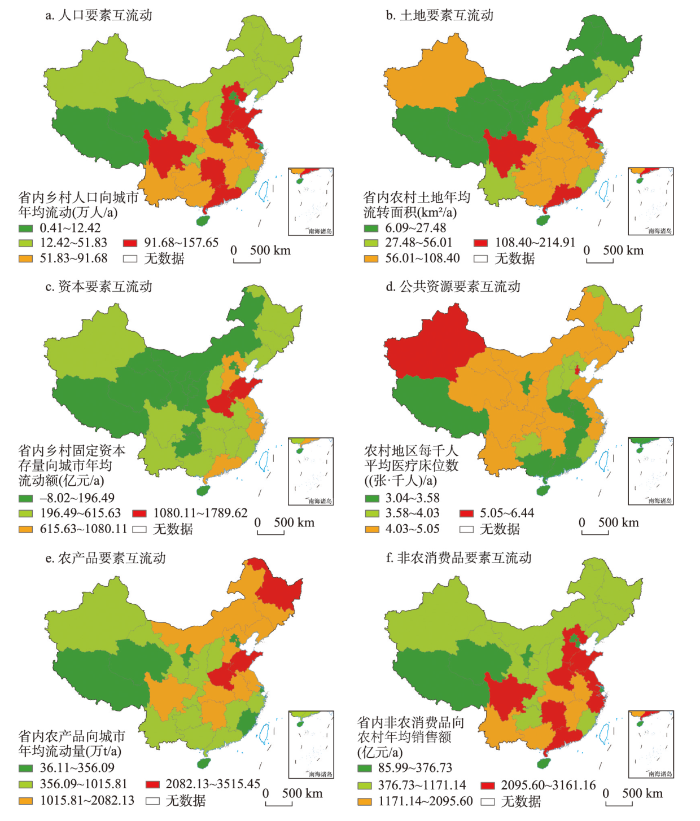
图3
2013—2020年中国省域城乡要素年均互流动空间格局
注:基于自然资源部标准地图服务网站审图号为GS(2016)1569号的标准地图制作,底图边界无修改。
Fig. 3
Spatial pattern of annual mutual flow of urban-rural factors in China from 2013 to 2020
4.1.2 演进过程
2013—2020年社会再生产过程中各要素互流动综合强度均呈现上升趋势(图4)。其中,2013—2019年生产环节的要素互流动强度以小幅波动为主,2019年后强度明显增大。中介环境的要素互流强度在研究期内逐年增长,互流强度与增速明显高于生产、消费环节。消费环节的要素互流动强度整体呈上升趋势,但增速逐渐降低。
图4
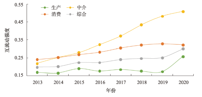
图4
2013—2020年中国城乡要素互流动强度指数变化
Fig. 4
Change of intensity index of mutual flow of urban-rural factors in China from 2013 to 2020
4.2 “区际流动”特征分析
4.2.1 空间格局
2013—2020年中国不同类型城乡要素“区际流动”存在显著的空间差异。人口要素区际流动呈现“内陆流向沿海”格局,其中,人口流出的省份共17个,占样本量的54.8%,中部地区的湖南、湖北、江西、安徽和山西,东北地区的吉林和黑龙江是主要的人口流出省份;人口流入的省份共14个,广东、浙江是主要的人口流入省份,西部地区受“西部大开发”政策影响,存在少量的人口回流(图5a)。资本要素区际流动呈现“东高西低”格局,河南、山东和江苏外部资本流入规模较大,西北地区外部资本流入规模较小(图5b)。技术要素区际流动集中在中东部部分省份,广东、浙江、河南、山东、北京、湖南和安徽等省份的区际流动较大。区际技术流动规模较小的省份主要分布在西部地区,但在东部的福建、江苏和东北地区的吉林、黑龙江,中部的山西也有分布(图5c)。农产品在三大平原区和四川盆地区为主要流出区域;农产品为区际流入的省份共5个,分别为北京、天津、上海、浙江和广东;其余省份的农产品的生产可满足本省消费需求,呈现为少量的外流(图5d)。
图5
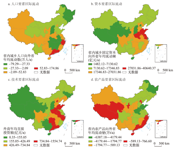
图5
2013—2020年中国各省份城乡要素年均区际流量空间格局
注:基于自然资源部标准地图服务网站审图号为GS(2016)1569号的标准地图制作,底图边界无修改。
Fig. 5
Spatial pattern of annual inter-regional flow of urban-rural factors in China from 2013 to 2020
4.2.2 演进过程
2013—2020年社会再生产过程中各要素区际流动综合流动强度增加趋势不明显。其中,生产环节的要素区际流动强度逐年上升,但在2013—2019年增长缓慢,其强度显著低于中介、消费环节。中介环节的要素区际流动强度在2013—2017年波动上升,在2017—2020年波动下降。消费环节的要素区际流动强度在2013—2017年缓慢波动上升,在2017—2020年趋于稳定(图6)。
图6
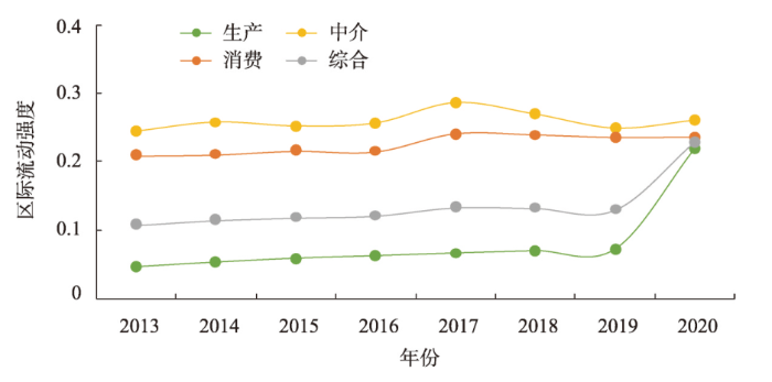
图6
2013—2020年中国城乡要素区际流动强度指数变化
Fig. 6
Change of intensity index of inter-regional flow of urban-rural factors in China from 2013 to 2020
5 中国城乡要素流动的机制分析与优化路径
5.1 城乡要素流动影响因素与作用机制
中国省域城乡要素流动存在明显的空间分异特征,城乡要素禀赋差异决定了空间差异的基本格局。城乡要素禀赋主要包括自然本底条件、产业经济基础和社会文化特征等因素。其中,自然本底条件包括地形地貌、气候条件、资源丰度和农业生产条件等[34],决定了农业生产、城乡建设活动强度等区域社会经济活动;产业经济基础主要包括经济区位、产业结构、地方财政、城镇化水平以及城乡居民收入水平和差距等[35],要素之间相互作用并形成了产业比较优势差异,导致社会再生产过程中城乡要素流动的空间差异;区域社会文化特征受自然和经济基础影响,主要包括区域发展历史、思想观念和生活方式等,形成了不同偏好的社会再生产过程,引起城乡要素流动类型、强度差异。河南、山东、江苏和四川人口密集、城市化进程较快[36],农业生产的耕地基础丰富,机械化与科技化水平较高,在社会再生产中,兼以农业生产和非农业生产,生产阶段要素以省域内的城乡互流动为主。广东和浙江是东部沿海省份,人口密集、产业发展基础好,但区域内耕地资源有限、人地矛盾较为突出,在社会再生产中,以大规模非农业生产为主,生产、消费环节对省域外人口、农产品要素的需求较大。东北地区土地资源丰富,是农产品主产区[37],但人口流失、土地生态退化等问题对区域可持续发展的影响巨大[36],在社会再生产中,仍以农业生产为主,是农产品输出的主要地区。西北地区受自然环境约束明显,社会再生产规模相对较小,省域内城乡要素互流动有限,部分要素依赖于区际流动输入,相对传统的生产生活方式,使得资本要素和技术要素在该地区的流动强度明显小于其他地区。
除城乡要素禀赋基础外,政策规划、城乡建设、系统治理等干预手段对中国城乡要素流动具有重要的调控作用。中国实施的西部大开发、东北振兴、中部崛起以及东部率先发展等区域协调发展战略,不仅有效缩小了区域差异、实现均衡高效发展,也在一定程度上改变了城乡要素流动的时空格局,催进生产要素跨地区自由流动。从全国尺度来看,人为干预手段主要改变了城乡要素流动强度的变化。2013—2020年以中介环节为代表的城乡要素互流动强度增速逐渐放缓,这与中国经济发展方式的转型有关。2017年中国共产党“十九大”提出“高质量发展”,中国从以基建投资拉动社会再生产的模式逐渐转向注重经济、社会、生态多维度的可持续发展模式,互流动强度增速放缓。从省域尺度来看,人为干预手段主要通过改变省域城乡要素流动的区际流动,从而促使城乡要素互流动优化。本文中,新疆的人口、土地等要素流动要显著高于周边省份,主要受“西部大开发”等区域均衡发展战略影响,人口、农产品等要素通过区际流动输入扩大社会再生产[38],从而促进土地要素等的互流动。
城乡要素流动的产生和发展,以社会再生产过程的规模化和复杂化为基础,并贯穿于生产、中介和消费等相对独立、互为关联的环节中。生产和消费环节的城乡要素流动取决于城乡(生产)要素市场和产品市场的供需关系,广东、山东和河南等省份的城乡人口规模较大,社会再生产中的生产和消费规模显著高于其他区域,导致城乡要素流动量较大。中介环节的要素流动主要满足生产、消费需求,并间接调节生产、消费环节的要素流动。例如,城乡之间交通设施建设、公共服务资源投入分别影响城乡居民产品消费偏好和人口流动[19,39]。本文的研究结果表明,城乡要素流动的时空分异,是城乡要素禀赋和人为干预调控综合作用于社会再生产过程,所形成的区域差异(图7)。其中,城乡要素禀赋为社会再生产提供基础,决定了区域承载社会再生产规模的理论上限;人为干预调控以区域城乡要素供求关系为基础,在一定程度上优化区域城乡要素的耦合协调,从而扩大实际社会再生产规模。社会再生产的运行,表现为各类城乡要素在多尺度下的流动;而城乡要素的合理流动,使得社会再生产过程的各个环节稳定运行。在城乡融合与乡村振兴过程中,应充分考虑区域自然、生态、人文等要素禀赋差异,针对不同尺度的要素流动特征,选择合理的人为干预手段,优化配置社会再生产过程各环节要素,实现城乡要素的自由双向流动。
图7
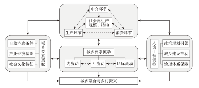
图7
城乡要素流动影响因素及作用机制
Fig. 7
Influencing factors and mechanism of urban-rural factor flow
5.2 城乡要素流动优化路径
中国地域辽阔、城乡差异巨大,城乡要素禀赋空间分布不均衡,不同区域的城乡要素禀赋提升应遵循“普适性”和“差异性”原则,通过工程技术[40]、资源跨区域运输[41]、交通和基础设施建设[19]等手段,促进多要素耦合、加强跨区域要素流动,全面缩小区域资源禀赋差异和提升承载能力。同时,充分考虑区域资源环境本底、社会经济等基础条件,因地制宜地发挥区域比较优势,优化城乡要素流动。具体来说,对于黄淮海平原和四川盆地区域,需立足自身优势,加强城乡基础设施一体化建设、健全城乡要素市场,优先实现要素高质量流动;对于东南沿海地区,可通过优化乡村资源利用效率、生产过程和生活方式[42],提升要素流动所需的资源环境承载能力,缓解生产环节的人地冲突和资源环境问题,并充分利用区位优势,畅通要素国际国内“双循环”,扩大消费内需[43-44],促进消费环节的城乡要素合理流动,扩大各类城乡要素流动的规模;对于东北地区,应立足粮食生产功能,改善城乡要素流动的中介环境,避免农业劳动力快速流失,通过扩大城乡要素互流动强度,调控城乡要素区际流动的强度和方向,提高城乡发展的内生动力;对于西北边远地区,亟需加强社会再生产各阶段的要素流动,优化城乡要素内流动、互流动,通过改善地区交通物流设施条件和空间治理体系[37,45],优化城乡要素流动的媒介载体,实现与中东部地区的优势资源互补;并通过地方特色产品和生态旅游产业,加强城乡要素区际流动,提升城乡发展活力。
此外,中国通过政策规划、城乡建设以及系统治理等方式,实现了城乡要素流动的优化调控。但是仍存在全国统一的要素市场尚未建成[46]、城乡要素流动失衡导致的城乡收入差距较大[47]、基层城乡要素市场治理能力较弱等问题。因此,需要从多尺度入手,实现城乡要素的自由双向流动,促进城乡融合与乡村振兴。具体来说,在全国尺度,应继续推进区域协调发展战略,通过构建“双循环”格局、加快建设全国统一大市场,优化城乡要素区际流动,实现区域可持续发展;在省域尺度,应根据各省城乡要素流动现状,基于本省特色产业,以发展规划等方式优化城乡要素流动的类型和规模,并在政策驱动下打破城乡要素市场壁垒,通过加强交通设施建设、公共服务资源投入,减小社会再生产过程城乡要素互流动的摩擦,促进城乡产品、产业、文化、公共服务的多维融合[7];在乡村与城市系统的尺度,应注重自上而下的政策规划和自下而上的能人治理、公众参与相结合[48],通过因地制宜地开展村庄规划、农村基础设施建设和人居环境整治等,确保宏观政策与实际结合,使城乡要素合理内流动,实现乡村振兴。
6 结论
本文基于社会再生产理论,阐述了城乡要素流动内涵,提出了城乡要素流动的测度方法,并定量分析了2013—2020年中国省域尺度城乡要素流动的空间格局与演进特征。主要结论如下:
(1)城乡要素流动泛指影响城市与乡村发展的要素数量与质量变化。城乡要素可划分为生产要素、中介要素和消费要素3类,基于省域内乡村系统和城市系统、省域外系统可将流动类型划分为内流动、互流动和区际流动3类。
(2)2013—2020年中国省域尺度的城乡要素“互流动”呈现显著的空间分异,人口、土地和社会消费品互流动呈现“东南高西北低”格局,资本互流动呈现“东高西低”格局,公共资源互流动在全国各省相对均衡,农产品互流动高值区则分布在农牧业大省所在区域。社会再生产环节的要素互流动强度呈现上升趋势,中介环节要素互流动强度与增速明显高于生产、消费环节。
(3)2013—2020年不同类型要素“区际流动”的空间差异明显,人口区际流动由内陆省份流向沿海省份,资本区际流动呈现“东高西低”格局,技术区际流动高值区集中在工业发达省份,农产品区际流动主要由农牧业大省流向东南沿海、西北地区、直辖市地区。社会再生产环节的要素区际流动强度变化平稳,生产环节要素区际流动强度显著低于中介、消费环节。
(4)自然、经济、社会与文化等城乡要素禀赋和政策、规划与治理等人为调控手段通过调节社会再生产的规模和结构,影响城乡要素流动的强度和结构。应充分考虑区域要素禀赋差异,针对不同尺度的要素流动特征,选择合理的人为干预手段,优化配置社会再生产过程各环节要素,实现城乡要素的自由双向流动。
参考文献
The basic theory and methodology of rural revitalization planning in China
DOI:10.11821/dlxb202006002
[本文引用: 1]

Agricultural and rural modernization is the general goal of the implementation of the rural revitalization strategy. The scientific formulation of the rural revitalization planning is related to the implementation effect of the national rural revitalization strategy. How to establish the basic theory of rural revitalization and develop the methods of rural revitalization planning have become important tasks of academic research and government decision-making. This paper constructed the theoretical model and method system of rural revitalization planning, tried to carry out the main function-oriented zoning, dominant type classification and principal purpose classification of rural regional system, and established the spatial system of rural revitalization planning and its optimal adjustment scheme. This system was applied to the overall rural revitalization planning in Yanchi County of Ningxia. By establishing the principle of rural revitalization planning that sticks to ecological priority, adaptation to local condition, industrial support and urban-rural integration, it put forward that the priority should be given to the development of rural professional cooperation organizations and the mixed economy of villages and towns, and the acceleration of the construction of advantageous industrial system characterized by the industrialization of tan-sheep, day lily, and minor cereals, and highlighted by the wisdom of eco-cultural tourism. Moreover, it was encouraged to give prominence to the position of the central town in space, and form the village organism and housing industry coordination body with the county seat and three key towns as the center of integrated industry development. The typical case study of Yanchi County has shown that the main contents and technical points of rural revitalization planning were embodied in the following four aspects: (1) determining the overall orientation of rural revitalization planning, and clarifying the phased development mode, key areas; (2) developing the county area based on the main function-oriented zoning, leading type classification and main purpose classification system, and exploring the territorial pattern and differentiation rules; (3) establishing the county development mode and industrial system, formulating coordination schemes of different main function-oriented zones, and revealing the spatial configuration and structural relationship of different dominant types; (4) exploring the local association and hierarchical system of each dominant type in its scale and level. The main task of implementing the rural revitalization planning is to promote the formation of a new pattern of urban-rural development with factors gathering, reasonable structure and orderly space in accordance with the objective requirements of "industrial prosperity, ecological livability, rural civilization, effective governance and prosperous life". China is facing great differences in rural development and many problems in transformation. Regional disparities and urban-rural differences determine the complexity, diversity and differences of rural governance and rural revitalization planning. China's rural transformation-urban and rural integration-rural revitalization-high quality development will become the major development logic and new normal in the future. The research on rural revitalization planning in the new era should focus on the overall situation of regional coordination and urban-rural integration, and solve the practical problems of "rural disease", so as to serve the national rural revitalization planning and scientific decision-making.
中国乡村振兴规划的基础理论与方法论
DOI:10.11821/dlxb202006002
[本文引用: 1]
农业农村现代化是实施乡村振兴战略的总目标,科学编制乡村振兴规划事关国家乡村振兴战略的推进及实施成效。《全国乡村振兴战略规划(2018—2022)》提出以来,如何建立符合中国乡村发展基本特点与规律的乡村振兴规划基础理论,研制县域乡村振兴规划方法与方案,成为当前学术研究及政府决策的重要课题和重点任务。基于乡村地域多体系统理论,构建了乡村振兴规划理论模式,提出了“三主三分”乡村振兴规划方法。“三主三分”的基本原理是依据特定区域乡村地域系统结构与格局,进行地域系统主体功能分区、主导类型分类、主要用途分级,确立乡村振兴规划空间体系及其优化调整方案。该体系运用于宁夏回族自治区盐池县乡村振兴总体规划,制定了坚持生态优先、因地制宜、产业支撑、城乡融合的乡村振兴规划原则,提出应重点发展乡村专业合作组织和村镇混合制经济,加快建设以滩羊、黄花、小杂粮产业化为特色、生态文化旅游智慧化为亮点的优势产业体系;在空间上突出中心城镇地位,形成以县城和3个重点镇为中心、“三产”融合发展的村镇有机体、居业协同体。本研究是对创建中国乡村振兴规划体系的有益尝试,可为全国县级乡村振兴规划与乡村发展决策提供参考依据。
Human geography research based on the new thinking of global rural-urban relationship
DOI:10.11821/dlxb202112001
[本文引用: 3]
Sustainable rural development is critical to the achievement of global sustainable development goals. Globalization and urbanization, as the key processes, continuously drive the human-earth system to make adaptive responses, promoting the transformation of urban-rural relations. The rural-urban relationship is essentially a mother-child relationship, which is a comprehensive characterization of the transfer of rural humanistic factors, the transformation of man-land relationship and the transformation of urban-rural development in the process of urbanization. However, the traditional cognition of urban-rural relationship ignores the multi-dimensional connections between the rural and the urban as well as the existence of the rural-urban integration system, resulting in prominent drawbacks of rural regions, negatively affecting the urban-rural development rights, and resulting in urban and rural territorial dysfunction and other problems. The key to solve the problems of socio-economic development in China is to reform the urban-biased development strategy, and to innovate the new cognition of rural-urban relationship based on the thinking of "rural maternal effect", which highlights that rural areas nourish the city. Based on the remote coupling and systematic synthesis of the rural human-earth system, modern human geography urgently needs to strengthen the cross-research with physical geography and information geography, create a coordinated observation system of human-earth system supported by the sky-space-ground integration, reshape the global rural development perspective, rural-urban system perspective, and reorganize the global rural human-earth relationship, the rural-urban integration relationship, and the living and employment relationship. Rural human-earth relationship territorial system is the core of rural geography research. The rural human-earth system research should focus on the coupling of rural natural ecosystem and the socio-economic system and their complex interactive processes and effects. Supported by the intersection of multiple disciplines, the expansion of new fields and the cultivation of new disciplines, it should create the collaborative observation technology of human-earth system and methodology of multi-source data fusion computing, the research idea based on process-mechanism-pattern and the technical path of monitoring-simulation-decision support, and explore the organic connection path between rural human-earth system coupling and rural-urban integrated development, regional sustainable development and global common governance.
全球乡城关系新认知与人文地理学研究
DOI:10.11821/dlxb202112001
[本文引用: 3]
全球化、城镇化作为驱动人地系统不断做出适应性调整和改变的关键过程,持续推动着城乡关系的转型与重塑。本文认为乡村孕育了城市,乡城关系实质上是母子关系,是城镇化进程中乡村人文要素转移、人地关系转变、城乡发展转型的一种综合表征,具体体现在不同发展阶段乡村与城市之间土地非农化、人口城镇化、产业园区化、城乡发展一体化等诸多方面;传统的城乡关系认知忽略了城市与乡村之间的内在关系和多维联系,以及城乡融合系统这一重要地理综合体及其功能价值,成为产生乡村短板效应凸显、城乡发展权能受损、城乡地域功能紊乱等突出问题的根源;转变城市偏向发展观念,基于乡村母体思维,创新全球乡城关系新认知是破解当前全球化特别是中国社会经济发展不平衡、不充分问题的关键所在。现代人文地理学迫切需要强化与自然地理学、信息地理学交叉研究,创建天—空—地一体化人地系统协同观测体系,突出乡村人地系统的远程耦合性和系统综合性,重塑全球乡村观、乡城系统观,探究可持续的全球乡村人地关系、城乡融合关系、村镇居业关系。乡村人地系统研究应聚焦乡村自然生态系统、社会经济系统耦合及其复杂交互过程与效应,以多学科交叉、新领域拓展与新学科培育为支撑,创建人地系统协同观测技术与多源数据融合计算方法论,基于过程—机理—格局的研究思路和监测—模拟—决策支持的技术路径,探寻实现乡村人地系统耦合与乡城融合发展、区域可持续发展及全球共同治理的有机衔接路径。
A factor-based theoretical analysis of urban-rural relationship change
DOI:10.18306/dlkxjz.2021.08.004
[本文引用: 2]
Urban-rural integration is an important support for the implementation of the new urbanization strategy and the rural revitalization strategy, while the reasonable flow and optimal allocation of urban-rural elements are the keys to the change of urban-rural relationship and urban-rural integration. Based on the theory of urban-rural regional system, this study examined the essence and connotation of urban-rural relationship from the perspective of elements, clarified the stages and general features of urban-rural relationship change, and then put forward its regulatory mechanism. The main conclusions are as follows: 1) Urban-rural relationship is the concentrated embodiment of urban-rural population relationship, land relationship, and economic relationship. The foundation of urban-rural relationship is the functional differences and complementarity between them and the representation is the flow of urban and rural elements. 2) The pattern of the development of urban-rural relationship is from differentiation to integration. Its evolution process can be generally divided into four stages: urban-rural differentiation, urban-rural opposition, urban-rural integrated development, and urban-rural integration. There are clear differences in the type, direction, ways, intensity, and degree of freedom of urban and rural element flow in different periods and regions. 3) Under the effect of economic mechanism and political mechanism, the flow of various elements constantly promotes the evolution of urban-rural relationship. The adjustment of urban-rural relationship should also continually improve and optimize the economic and political mechanisms.
基于要素视角的城乡关系演化理论分析
DOI:10.18306/dlkxjz.2021.08.004
[本文引用: 2]
城乡融合发展是新型城镇化战略与乡村振兴战略的重要支撑,城乡要素的合理流动与优化配置是城乡关系演化与城乡融合发展的关键。论文基于城乡地域系统理论,从要素视角深入揭示城乡关系的本质与内涵,厘清城乡关系演化阶段及其特征,进而提出其调控机制。主要结论有:① 城乡关系是城乡人口关系、土地关系、经济关系等关系的集中体现,产生的根源在于城乡之间的功能差异性与互补性,表征是城乡间要素的流动;② 从分化到融合是城乡关系发展的客观规律,其演化过程一般分为城乡分化、城乡对立、城乡融合和城乡一体化4个阶段,不同时期不同区域城乡要素流动的类型、方向、方式、强度及自由度等具有明显差异;③ 在经济机制和政治机制的作用下,多种要素的流动不断推动着城乡关系的演进,城乡关系的调控亦应不断完善和优化经济机制和政治机制。
Research on the urban-rural integration and rural revitalization in the new era in China
DOI:10.11821/dlxb201804004
[本文引用: 1]
Cities and villages are components of a specific organism. Only the sustainable development of two parts can support the prosperous development as a whole. According to the theory of man-earth areal system, urban-rural integrated system and rural regional system are the theoretical bases for entirely recognizing and understanding urban-rural relationship. To handle the increasingly severe problems of "rural disease" in rapid urbanization, accelerating rural revitalization in an all-round way is not only a major strategic plan for promoting the urban-rural integration and rural sustainable development, but also a necessary requirement for solving the issues related to agriculture, rural areas, and rural people in the new era and securing a decisive victory in building a moderately prosperous society in all respects. This study explores the basic theories of urban-rural integration and rural revitalization and analyzes the main problems and causes of rural development in the new era, proposing problem-oriented scientific approaches and frontier research fields of urban-rural integration and rural revitalization in China. Results show that the objects of urban-rural integration and rural revitalization is a regional multi-body system, which mainly includes urban-rural integration, rural complex, village-town organism, and housing-industry symbiosis. Rural revitalization focuses on promoting the reconstruction of urban-rural integration system and constructs a multi-level goal system including urban-rural infrastructure networks, zones of rural development, fields of village-town space and poles of rural revitalization. Currently, the rural development is facing the five problems: high-speed non-agricultural transformation of agriculture production factors, over-fast aging and weakening of rural subjects, increasingly hollowing and abandoning of rural construction land, severe fouling of rural soil and water environment and deep pauperization of rural poverty-stricken areas. The countryside is an important basis for the socioeconomic development in China, and the strategies of urban-rural integration and rural revitalization are complementary. The rural revitalization focuses on establishing the institutional mechanism for integrated urban-rural development and constructs the comprehensive development system of rural regional system, which includes transformation, reconstruction and innovation in accordance with the requirements of thriving businesses, pleasant living environments, social etiquette and civility, effective governance, and prosperity. Geographical research on rural revitalization should focus on the complexity and dynamics of rural regional system and explore new schemes, models and scientific approaches for the construction of villages and towns, which are guided by radical cure of "rural disease", implement the strategy of rural revitalization polarization, construct the evaluation index system and planning system of rural revitalization, thus providing advanced theoretical references for realizing the revitalization of China's rural areas in the new era.
中国新时代城乡融合与乡村振兴
DOI:10.11821/dlxb201804004
[本文引用: 1]
城市与乡村是一个有机体,只有二者可持续发展,才能相互支撑。依据人地关系地域系统学说,城乡融合系统、乡村地域系统是全新认知和理解城乡关系的理论依据。针对日益严峻的“乡村病”问题,全面实施乡村振兴,既是推进城乡融合与乡村持续发展的重大战略,也是破解“三农”问题,决胜全面建成小康社会的必然要求。本文探讨了新时代城乡融合与乡村振兴的基础理论,剖析了乡村发展面临的主要问题,提出了问题导向的中国城乡融合与乡村振兴科学途径及研究前沿领域。结果表明:① 城乡融合与乡村振兴的对象是一个乡村地域多体系统,包括城乡融合体、乡村综合体、村镇有机体、居业协同体,乡村振兴重在推进城乡融合系统优化重构,加快建设城乡基础网、乡村发展区、村镇空间场、乡村振兴极等所构成的多级目标体系。② 中国“三农”问题本质上是一个乡村地域系统可持续发展问题,当前乡村发展正面临主要农业生产要素高速非农化、农村社会主体过快老弱化、村庄建设用地日益空废化、农村水土环境严重污损化和乡村贫困片区深度贫困化等“五化”难题。③ 乡村是经济社会发展的重要基础,城乡融合与乡村振兴战略相辅相成,乡村振兴应致力于创建城乡融合体制机制,推进乡村极化发展,按照产业兴旺、生态宜居、乡风文明、治理有效、生活富裕的要求,构建乡村地域系统转型—重构—创新发展综合体系。④ 乡村振兴地理学研究应着眼于乡村地域系统的复杂性、综合性、动态性,探究以根治“乡村病”为导向的新型村镇建设方案、模式和科学途径,为实现新时代中国乡村振兴战略提供理论参考。
Theoretical analysis on the mechanism and evolution law of urban-rural integration development
DOI:10.11821/dlxb202204001
[本文引用: 1]
Urban and rural areas are always an inseparable organic integration, and the high-quality new urbanization is the process of urban-rural integration and rural revitalization. "urban disease" and "rural disease" are connected with each other, and are the causes of each other, which are known as "urban and rural diseases". The radical cure of "urban disease" and "rural disease" requires rural revitalization and new urbanization. Based on the review of the research on urban-rural integration development at home and abroad, this study analyzes the pathological roots and opposition pattern of urban and rural areas from the theoretical level, explores the main controlling factors, driving mechanism, sustainability and four-stage regularity of urban-rural integration development, constructs the measurement test system of urban-rural integration development, and puts forward the triangular model of urban-rural multi-integration development. It is known that the urban-rural integration development in China is in the high integration stage of more towns and less villages in the late urbanization, and will enter the deep integration stage of more towns and less villages, namely the final stage of urbanization. This study explores the policy evolution path of urban-rural integration development in China since the founding of the People's Republic of China in 1949. China has generally experienced the policy evolution process from urban-rural coordinated development to the integration of urban-rural development and then to urban-rural integration development, and played an important guiding role in promoting new urbanization and rural revitalization. From the path level, it is suggested that the Central Urban and Rural Work Conference should be jointly convened, the National Urban-Rural Integration Development Plan should be jointly compiled, and the strategy of deep integration of urban-rural development should be implemented. The new urbanization and rural revitalization should be used as two different means to solve urban and rural diseases and improve the quality of urban and rural development. The theory and method of urban-rural integration development should be innovated, and the evaluation system should be constructed to quantitatively evaluate the depth of urban-rural integration development and build beautiful cities and beautiful villages. We should promote the development of new urbanization and rural revitalization in the direction of high synchronization, deep integration and co-prosperity, as well as improve the quality of urban and rural development and realize urban and rural modernization in a comprehensive way.
城乡融合发展机理与演进规律的理论解析
DOI:10.11821/dlxb202204001
[本文引用: 1]
城市与乡村始终是一个不可分割的有机融合体,高质量的新型城镇化过程就是城乡融合发展与乡村振兴过程。“城市病”因乡村病而生,“乡村病”也因城市病而生,“城市病”与“乡村病”同病相连,互为病因,复合叠加形成“城乡病”,根治“城市病”必须通过乡村振兴,根治“乡村病”也必须通过新型城镇化。本文在对国内外城乡融合发展研究综述的基础上,从理论层面分析了城乡病理病根及对立格局,解析了城乡融合发展的主控要素、驱动机制、城乡融合发展的规律性和持续性,构建城乡融合发展测度试验系统,提出了城乡多融合发展的三角模式,验证了中国城乡融合发展正处在城镇化后期城多乡少的高度融合阶段,未来将迈入城镇化终期城多乡少的深度融合阶段。从政策层面分析了中华人民共和国成立以来国家有关城乡发展政策的演进路径,总体经历了从城乡二元发展、城乡协调发展、城乡统筹发展、到城乡一体化发展、再到城乡融合发展的政策演进过程,这些政策对推动新型城镇化和乡村振兴发挥了重要指导作用。从路径层面建议合并召开中央城乡工作会议,合并编制《国家城乡融合发展规划》,实施城乡深度融合发展战略,把新型城镇化与乡村振兴同时作为解决城乡病、提升城乡发展质量的两种不同手段,创新城乡融合发展理论与方法,构建评估体系定量评判城乡融合发展程度,建设美丽城市和美丽乡村。推动新型城镇化与乡村振兴向高度同步化、深度融合化和共荣化方向发展,同步提升城市发展质量和乡村发展质量,同步实现城市现代化和乡村现代化。
Review of urban-rural integration evaluation: Connotation identification, theoretical analysis, and system reconstruction
DOI:10.31497/zrzyxb.20211013
[本文引用: 2]
The scientific evaluation of urban-rural integration is the core content of urban-rural integration, and it is the foundation for establishing and improving the institutional mechanism of urban-rural integration. Based on the logical line of "connotation identification-theoretical analysis-system reconstruction", this paper carries out the review of urban-rural integration evaluation including concept connotation, theoretical basis, evaluation index, evaluation method, evaluation scale, spatio-temporal differentiation, and mechanism analysis. At present, the academic understanding of the connotation of urban-rural integration is basically the same. The evaluation index selection of urban-rural integration shows multidimensional and multi-attribute characteristics, but the index system construction has not broken through the static characteristics. Quantitative evaluation method is relatively simple. Generally, current research still remains at the macro scale, but lacks quantitative research from a micro perspective and comparative studies of different fusion modes. The spatial and temporal differentiation pattern and its mechanism of urban-rural integration need to be further deepened. Finally, this paper puts forward five prospects: (1) strengthening the construction of basic theory system and perfecting system research framework; (2) optimizing the multidimensional evaluation index system and identifying the development model of urban-rural integration; (3) deepening the flow mechanism of urban and rural elements and promoting the balanced development of urban and rural space; (4) strengthening the exploration of micro-scale details and improving the promoting mechanism of urban-rural integration; (5) strengthening the empowering role of the digital economy and innovating the development mechanism of high-quality urban-rural integration.
城乡融合评价研究综述: 内涵辨识、理论认知与体系重构
DOI:10.31497/zrzyxb.20211013
[本文引用: 2]
科学的城乡融合评价是城乡融合工作的重要环节,是建立健全城乡融合体制机制的基础。以“内涵辨识—理论认知—体系重构”为逻辑主线,从城乡融合的概念内涵、基础理论、评价指标、评价方法、评价尺度及演化机理等方面,开展城乡融合评价综述。研究表明:学界对城乡融合概念与内涵的认识基本一致,且已有一定理论基础;城乡融合评价指标选取呈现多维化、多属性化特征,但指标体系构建尚未突破静态性层面;定量评价方法较为单一;研究尺度整体偏向中宏观,缺少微观视角下的量化以及不同融合模式对比研究;城乡融合的时空分异格局及其机理研究亟待进一步深化。对此,提出了以下五点展望:(1)加强基础理论体系建设,完善系统研究框架构建;(2)优化多维评价指标体系,识别城乡融合发展模式;(3)深化城乡要素流动机制,推动城乡空间均衡发展;(4)加强微观尺度细节挖掘,健全城乡融合推进机制;(5)强化数字经济赋能作用,创新城乡高质量融合发展机制。
Research on the realization path of urban-rural integration development with a perspective of urban-rural "convection"
DOI:10.7522/j.issn.1000-694X.2021.00216
[本文引用: 6]
Promoting the mutual exchange and two-way flow of various "energy" between urban and rural areas is an inevitable requirement for the integrated development of urban and rural areas and rural revitalization in the new era. This paper analyzes the connotation of urban-rural integration and urban-rural "convection", and explores the mechanism and basic path of urban-rural "convection" to promote the development of urban-rural integration. Urban-rural integration is a dynamic process of interaction between urban and rural areas. The connotation of urban-rural integration can be explained in terms of overall thinking, basic path, main dimensions, key content, and realization process. Urban-rural convection is the image expression of urban-rural interaction, and is a basic measure and method to promote the development of urban-rural integration. It mainly includes element "flow", industry "flow", product "flow", public service "flow" and cultural concept "flow". Urban-rural convection, through spillover effects and synergistic effects, realizes a virtuous cycle of resource elements, optimizes and coordinates structure and functions, and reshapes the development space pattern to promote the integration of urban and rural development. The integration of urban and rural development from the perspective of urban-rural convection needs to promote the two-way flow of urban and rural elements, the restructuring of urban and rural industries, the reconstruction of urban and rural commerce circulation systems, the interconnection of public services, and the complementarity of urban and rural cultural exchanges.
城乡“对流”视角的城乡融合发展路径
DOI:10.7522/j.issn.1000-694X.2021.00216
[本文引用: 6]
推动城乡各种“能量”的相互交换和双向流动,是新时代城乡融合发展和乡村振兴的必然要求。本文分析了城乡融合和城乡“对流”的内涵,探讨了城乡“对流”推动城乡融合发展的机理和基本路径。城乡融合是城与乡相互作用的动态过程,可以从总体思路、基本路径、主要维度、重点内容、实现过程等方面阐述城乡融合的内涵。城乡对流是城乡互动的形象表达,是推动城乡融合发展的基本举措和方法,主要包括要素“流”、产业“流”、产品“流”、公共服务“流”和文化观念“流”。城乡“对流”通过溢出效应和协同效应,实现资源要素良性循环、结构功能优化协调、发展空间格局重塑,推动实现城乡融合发展。基于城乡“对流”视角的城乡融合发展需要推动城乡要素双向流动、城乡产业格局重构、城乡商贸流通体系重建、公共服务互联互通、城乡文化交流互补。
Economic development with unlimited supplies of labour
DOI:10.1111/j.1467-9957.1954.tb00021.x URL [本文引用: 1]
Economic space: Theory and applications
DOI:10.2307/1881960 URL [本文引用: 1]
Transforming traditional agriculture: Reply
DOI:10.2307/1236629 URL [本文引用: 1]
Characteristics and mechanism of urban and rural population mobility in Chang-Zhu-Tan Urban Agglomeration
长株潭城市群城乡人口流动特征及动力机制
How do population flows promote urban-rural integration? Addressing migrants' farmland arrangement and social integration in China's urban agglomeration regions
China’s urban–rural relationships have been changed dramatically by the intensifying population flows, especially in urban agglomeration regions. This study contributes to the interpretation of urban–rural integration mechanisms in urban agglomeration by constructing a conceptual framework of migration-related resource flows. Taking the Wuhan urban agglomeration as an example, migrants’ farmland arrangement, migration pattern, and social integration have been investigated to uncover the spatial and temporal characteristics of the urban–rural interaction, based on the data from the China Migrants Dynamic Survey in 2012–2017. The findings indicate that the farmland circulation in the Wuhan urban agglomeration was generally low, but slightly higher than that of the national average. The central city, Wuhan, had a high degree of family migration and social integration, indicating stronger resource flows in developed areas. However, its farmland circulation level was lower than that of non-central cities. The unsynchronized interaction of resources in urban and rural areas should be taken seriously, especially in areas with a relatively developed urban economy. The advantages of the central city in absorbing and settling migrants confirmed the positive impact of the urban agglomeration on promoting urban–rural integration.
Rural wealth creation of intellectual capital from urban local food system initiatives: Developing indicators to assess change
DOI:10.1080/15575330.2017.1354042 URL [本文引用: 1]
Small-town agricultural markets in northern Ghana and their connection to rural and urban transformation
DOI:10.1057/s41287-018-0171-2 [本文引用: 1]
Strengthening urban-rural resource flow through regional circular and ecological sphere (R-CES) approach in Nagpur, India
Urban and rural areas within a regional space are closely linked through a variety of linkages including the flow of people. The increasing pace of development transformations with discrete planning of urban and rural areas has raised serious concerns for achieving coordinated development at the regional level. In that regard, the concept of Regional Circular and Ecological Sphere (R-CES) has recently been introduced by the Government of Japan to localize the flow of resources between urban and rural areas. To understand the applicability of the R-CES approach, this study aims to visualize the flow of people within a defined cluster of Nagpur Metropolitan Area (NMA) in India. A “home interview method” Origin-Destination survey was adopted to analyze the flow patterns of people and their key purposes. Based on the collected information, flows of people were represented using a desire line diagram in ArcGIS 10.4.1. The study results revealed that the maximum flow of the rural and forest population is directed towards nearby or distant urban settlements to avail the higher-order urban services. Based on the key R-CES principles of a low-carbon society, circular economy, and harmony with nature, the authors suggest feasible directions for localizing the urban–rural flow of people in NMA.
Rural-urban mobility influences wildmeat access and consumption in the Brazilian Amazon
DOI:10.1017/S0030605321001575
URL
[本文引用: 3]
Research demonstrates substantial urban consumption of wildmeat and the existence of trade networks in the Brazilian Amazon. Yet rural–urban mobility persists in this urbanized region, with the circulation of people, goods and ideas, blurring boundaries between rural and urban lives. Here we examined the relationships between rural–urban mobility and wildmeat access in highly forested areas of central Brazilian Amazonia. We surveyed 798 urban households in four towns and 311 rural households in 63 riverine communities. Rural–urban mobility was common amongst urban households: 49.7% maintained rural livelihoods and 57.3% were headed by rural in-migrants. Although many urban consumers purchased wildmeat, gifting was equally important. Urban households with greater rural–urban mobility consumed more wildmeat and were less likely to purchase it. Buying wildmeat was rare in rural areas but emergent in larger rural communities. Rural consumption was greater in remote areas, non-floodplain communities and during the high-water season. Urban populations placed particular pressure on three preferred species: the lowland paca Cuniculus paca, tapir Tapirus terrestris and white-lipped peccary Tayassu pecari. Rural consumption was more diverse, and per-capita wildmeat consumption was four times greater in rural than urban households (21 vs 5 kg/person/year). Total estimated annual wildmeat consumption was 3,732 t across 43 riverine urban centres compared to 11,351 t in surrounding rural areas. Because of poverty in these towns and socially mediated wildmeat acquisition, it is debatable whether urban consumers should or could be denied access to wildmeat. Nonetheless, the probable future increase in urban demand and related risks to sustainable, equitable resource use necessitate the monitoring and management of rural–urban wildmeat flows.
Regional differences and convergence of urban-rural integration development from the perspective of factor flow
Driving mechanism of urban-rural integration in Huaihai Economic Zone: Based on the space of flow
DOI:10.31497/zrzyxb.20200810
[本文引用: 2]
To restructure the evaluation index system of urban and rural integration from population, space, economy, society and ecological environment, the dynamic coupling coordination model was selected to measure the urban and rural multi-dimensional integration level, and the global Moran index and the local indicators of spatial association (LISA) were used to reveal the spatial distribution characteristics of the urban-rural multi-dimensional integration level in Huaihai Economic Zone. And then, the spatial correlation pattern in the study area was analyzed by the spatial structure index (SSI) from the population flow, logistics flow, capital flow and information flow. And finally, the driving mechanisms of urban-rural integration in the study area were explored by the fixed effect spatial error model (SEM-FE) from the perspective of these four types of flow. The results are as follows: (1) The urban-rural multi-dimensional integration levels are low but go well, the overall level in the research area rose from 0.016 in 2003 to 0.028 in 2017, with an annual rate of 0.08%. When the urban-rural multidimensional integration structure maintains stable in the research period, the economic integration is the highest, while the spatial integration is the lowest. (2) The regional interrelation is close in the context of population flow and capital flow, while it shows a "core-periphery" structure under the material flow and information flow. In general, the spatial structure in Huaihai Economic Zone is a decentralized network with multiple central cities, which lays a good foundation for the future development of urban-rural integration and inter-regional coordinated development. (3) In order to achieve the improvement of quantity and quality of urban-rural integration in Huaihai Economic Zone, we should shift the effect of the core area from agglomeration to diffusion, and need reasonable labor distribution and trading to stimulate the regional comparative advantage fully of each city node. Moreover, it is necessary to assist a series of cultural, economic and political systems in the implementation of local and national policies, because urban and rural integration development is a big cycle system of the socio-economy.
流空间视域下淮海经济区城乡融合发展驱动机制
DOI:10.31497/zrzyxb.20200810
[本文引用: 2]
从要素流动多维重构淮海经济区城乡融合评价体系,以动态耦合协调度模型测度城乡融合水平并分析其时空分异规律,最后从“流空间”视角探索城乡融合发展驱动机制。结果表明:(1)研究区城乡融合水平整体较低但趋势向好,其正向空间关联和局域内向集聚特征明显。(2)流空间视角下区域呈多中心网络结构,且在人流和资金流下相对紧密,而物流和信息流下“核—辐”结构突出。(3)推动核心区集聚效应转向扩散效应,发挥各城市节点比较优势,合理调节要素流动强度、方向和质量,并在实施地方和国家政策时配套相关制度,方能实现淮海经济区城乡融合“量”“质”同升。
The spatial flow characteristics and optimization of urban and rural elements in provincial fringe areas from the perspective of "flow space": A case study of Qingyang
“流空间”视角下省际边缘区城乡要素空间流动特征与优化: 以庆阳市为例
Income inequality in China and its influential factors
中国收入差距的走势和影响因素分析
Exploration and thinking on promoting the reform of the system and mechanism of the free flow of urban and rural factors: Taking Chengdu as an example
推进城乡要素自由流动体制机制改革的探索与思考: 以成都市为例
How does land allocation promote urban-rural multi-dimensional integration? An efficient market and effective government
土地要素配置如何促城乡多维融合? 有效市场和有为政府
How do rural-urban linkages change after an extreme flood event? Empirical evidence from rural communities in Pakistan
Integration across a metacoupled world
Sustainability in the Anthropocene: Telecoupling framework and its applications
DOI:10.11821/dlxb202011010
[本文引用: 1]
With increasing global integration, distant coupled human and natural systems have more interactions than ever before, which often lead to unexpected outcomes with profound implications for sustainability. The integrated framework of telecoupling (socioeconomic and environmental interactions over distances) has been proposed to address such cross-border and cross-scale challenges, helping better evaluate and understand telecouplings. We first provide an introduction to the telecoupling framework, including components, definitions, and functions, and then offer an overview of the growing number of telecoupling studies. Particularly, we use three Chinese cases to illustrate the methods, results, significance, and implications of applying the telecoupling framework. We also point out some research gaps and critical unsolved questions in the applications. The telecoupling framework provides a powerful tool to incorporate feedbacks, trade-offs, and synergies across multiple coupled human and natural systems, and helps improve the understanding of distant interactions and the effectiveness of policies for socioeconomic and environmental sustainability across local to global levels.
人类世可持续发展背景下的远程耦合框架及其应用
DOI:10.11821/dlxb202011010
[本文引用: 1]
在全球一体化进程不断加深的背景下,国家与地区之间的联系日益紧密,产生了一系列跨国家、跨地区、多尺度的社会—经济—环境影响,远程耦合(Telecoupling,社会、经济、环境的远距离相互作用)科学概念和综合框架的提出为解决上述问题提供了新方法和新途径。为更好促进远程耦合综合框架的正确使用和规范推广,本文系统解析了远程耦合综合框架,厘清各组成部分的定义和功能,梳理了框架的应用现状;通过对3个中国典型案例的阐释,展示了远程耦合综合框架的使用方法、结果分析及由此得出的科学意义和政策价值;最后描述了远程耦合综合框架使用中需要重点关注的问题,并对其应用前景进行了展望。远程耦合综合框架的推广应用有助于以跨国家、跨地区、多尺度的视角,重新审视多个人类与自然耦合系统的相互作用,揭示隐藏的远距离地理空间作用的科学价值,服务于有关政策的制定和实施,促进全球社会、经济、环境的可持续发展。
Urban-rural integration and rural revitalization: Theory, mechanism and implementation
DOI:10.11821/dlyj201811001
[本文引用: 1]
Rural revitalization and urban-rural integration aim at narrowing the gap between urban and rural areas, promoting balanced development and realizing the equivalent life quality between urban and rural residents. Spatial equilibrium and its quantitative expression provide a new perspective to explain the pattern, process and mechanism of urban-rural integration and rural revitalization. Through the analysis of basic theory, this study discusses the scientific content and interaction between urban-rural integration and rural revitalization, sets up the urban-rural spatial equilibrium model, defines the urban-rural development isolines, works out the way to implement the urban-rural integration and rural revitalization in China, and addresses the potential for further research. The results show that: (1) Theory of regional system of man-land relationship and theory of spatial structure are the important theoretical basis for urban-rural integration and rural revitalization. The urban-rural integrated development depends on the all-round development of economy, society and environment with optimized spatial layout and innovative system, and rural revitalization mainly refers to the "pentagon of rural revitalization" and "people-land-capital-industry"; Urban-rural integration and rural revitalization strategy support each other, and the process of urban rural integration and rural revitalization is a dynamic equilibrium process between urban and rural areas. (2) The key issues of implementing rural revitalization and urban-rural integration can be illustrated through the urban-rural spatial equilibrium model, and the overall per capita benefits in rural areas gradually tend to be the same as that in cities by the re-optimization of urban-rural factors and population mobility; the dynamic process and mechanism of urban-rural integration spatial equilibrium is further interpreted via the urban-rural development isolines. (3) Exploring the implementation path of scientific rural revitalization strategy can achieve the goal of urban-rural integration and urban-rural spatial equilibrium development. The scientific path of rural revitalization is discussed from the perspectives of policy system construction, "pole-axis" spatial progressive diffusion, sub-area classification and typical development pattern, and it can provide theoretical reference for the strategy implementation of China's rural revitalization.
城乡融合与乡村振兴: 理论探讨, 机理阐释与实现路径
DOI:10.11821/dlyj201811001
[本文引用: 1]
缩小城乡差距,促进城乡均衡发展,实现城乡居民生活质量等值,是乡村振兴和城乡融合发展的重要目标。通过基础理论的分析,探讨了城乡融合与乡村振兴科学内涵,剖析了城乡融合与乡村振兴的相互关系,构建了城乡空间均衡模型和定义城乡等值线,提出了中国城乡融合与乡村振兴实现途径及需要深入研究的方向。结果表明:① 城乡融合发展是基于空间布局优化和制度供给创新的经济、社会、环境全面融合发展,“乡村振兴五边形”和“人—地—钱—业”是乡村振兴的核心内涵;城乡融合与乡村振兴战略相互支撑,城乡融合和乡村振兴的过程是城乡空间动态均衡的过程。② 城乡发展的空间均衡模型可以较好地阐释促进城乡融合发展、实施乡村振兴的关键问题,通过城乡要素的重新优化配置和人口的流动,城乡人均综合发展效益逐渐趋于相等;城乡等值线可以进一步解释城乡发展空间均衡的动态过程与传导机理。③ 从政策制度构建、“点轴”渐进扩散、分区分类推进、典型发展模式提炼等方面探讨乡村振兴的科学路径,可以为中国乡村振兴战略实施提供理论参考。
Theoretical framework and research priorities on food system couplings in an urbanization context
DOI:10.11821/dlxb202110002
[本文引用: 1]
Driven by urbanization, regional functional differentiation, optimal allocation of production factors, and rapid expansion of transportation networks, the flow of resources between regions has become a key impetus for regional sustainable development. Hence, the interaction networking between human beings and their natural environment requires a meta-coupling paradigm research from a geographic perspective, that is, to consider the human-nature interactions within the region, between the region and surrounding regions, and between non-adjacent regions simultaneously. As an industrial chain and value chain that connects rural areas and cities, as well as production areas and global consumer markets, the research on food system couplings is a good and important entry point for a better understanding the interactions and networking in the human-earth system. With this perspective in mind and aiming at demonstrating the theoretical study based on internal basis and external conditions, this paper combines the food system components with the tele-coupling framework to establish a "theoretical framework of local and tele-coupling of food systems driven by urbanization", and discusses the specific connotation of the theoretical framework. Taking the extension of the frontier fields in the theoretical framework as the basic guide and combining China's major strategic needs, the paper further identifies the basic issues for food system coupling research and four priority research directions that need to be breakthrough. Among them, the pattern characteristics, the spatio-temporal evolution and its driving mechanism of foodshed are the basic issues, while the four research priorities include: human-nature interaction research of the supply chain network coupling socio-economic and cultural changes and biogeochemical cycles; effects of the local and tele-coupling of food system and its regulatory strategies; the mechanism of urban-rural integration and long-term poverty alleviation based on food system; and cross-regional multi-level governance of food systems for public health and food security. A general technical methodology of the food system coupling research is designed at the end of the paper. The conceptual framework and methodology in this paper can provide theoretical guideline and enlightenment for further food system coupling research and other similar studies.
城市化背景下食物系统耦合研究的理论框架及优先方向
DOI:10.11821/dlxb202110002
[本文引用: 1]
受城市化、地域功能分化、生产要素优化配置和交通网络快速扩展等因素影响,区域之间资源要素的流动已成为区域可持续发展的内在需求。在这种背景下,人类与地理环境互动模式的网络化就要求地理学研究采取全程耦合范式,即将区域内部、区域与周边区域、以及非邻接区域之间的人地互动同时纳入考虑。食物系统作为衔接乡村与城市、以及产地与全球消费市场的产业链和价值链,是开展人地系统近远程耦合研究的重要切入点。基于这种认识,本文在论证理论研究内在依据及外在条件的基础上,将食物系统的构成要素与远程耦合框架相结合,建立“城市化驱动下食物系统近远程耦合的理论框架”并论述该理论框架的具体内涵。以拓展理论框架中的前沿领域为基本导向并结合国家重大战略需求,本文进一步明确了食物系统耦合研究的基本问题和4个亟待突破的优先研究方向。其中,基本问题是食物域的格局特征、时空演化及其动力机制。4个优先方向则包括:耦合社会经济文化变迁与生物地球化学循环的供应链网络人地互动研究;食物系统近远程耦合效应及其调控策略研究;基于食物系统的城乡融合与长效脱贫机制研究;以及面向公共卫生安全的食物系统跨区域、多层次治理研究。本文最后设计了食物系统耦合研究的一般技术路径,研究结果可为进一步的案例实证提供理论支撑和研究思路参考。
Domestic saving and international capital flows
DOI:10.2307/2231790 URL [本文引用: 1]
Regional capital flow and regional economic coordinated growth in China
我国区域资本流动与区域经济协调发展
Research on geographical elements of economic difference in China
DOI:10.11821/yj2009020017
[本文引用: 1]
<p>Much research has been done on the effect of geographical elements on economic difference throughout the world. Furthermore, based on the theory of two nature of metropolitan location proposed by Krugman, as well as the theory of human-land relationship and comparative advantages, this paper presents three geographical elements that affect economic differences. The first geographical element includes natural environment, i.e., elevation, slope, undulating topography, human climate index, water resource index, and potential agricultural production; the second consists of traffic and location, which are represented by transport facilitation and economic position respectively; and the third contains human capital and R&D level, respectively represented by years of schooling and the number of patents. Supported by Arcgis 9.0 software, this paper, through modeling, analyzes the impact of various geographical elements on economic difference within the whole country and three major regions. The result shows that the geographical environment plays an increasingly important role in economic development. In addition, it extends the knowledge of Sachs et al. about geographical elements of economic development. At present, China's economy is in transition. Among all geographical elements, the great one affecting economic difference is transport facilities index, reaching 0.374. So more capital should be injected in infrastructure construction in the future.</p>
中国区域经济差异形成的三次地理要素
Spatial pattern and influencing factors of quality of life in rural areas of Hunan province
DOI:10.11821/dlyj201812009
[本文引用: 1]
Understanding the regional differentiation regularities and causes of quality of life in rural areas is not only the new content of rural geography for a new era, but also the inherent requirement of the scientific implementation of the rural revitalization strategy. Taking 101 counties (cities, districts) of Hunan province as the research unit, this paper proposes a assessment indicator system of quality of life in rural areas consisting of six dimensions. Then, using the entropy method, exploratory spatial data analysis and geo-detector, we elaborate spatial pattern characteristics and influencing factors of quality of life in rural areas of the province. Our results suggest the following: (1) The spatial distribution pattern of quality of life indicates that the overall feature is high to low from the east to west and descends from east to west. (2) From the perspective of the spatial correlation pattern, obviously, the spatial pattern of High-High area and Low-Low area present a pattern of agglomeration. High-High area is mainly located in Changsha-Zhuzhou-Xiangtan urban agglomeration and its adjacent counties, while Low-Low area is mainly in western Hunan. (3) The primary factors influencing quality of life are per capita GDP, urbanization level, distance from provincial capital, and elevation. The secondary factors are the slope, the proportion of secondary and tertiary industries, the proportion of non-agricultural labor in rural areas, and total power of agricultural machinery. To realize rural revitalization and improve the quality of life in rural areas, we should give priority to rural industrial and economic revitalization based on eco-environmental protection, actively strengthen the interconnection between regions and enhance the modernization of infrastructure and public service facilities in rural areas.
湖南乡村生活质量的空间格局及其影响因素
DOI:10.11821/dlyj201812009
[本文引用: 1]
认知乡村生活质量的地域分异规律及形成原因,既是新时代乡村地理学研究的新内容,也是科学实施“乡村振兴”战略的内在要求。以湖南省101个县(市、区)为研究单元,构建由6个维度组成的乡村生活质量评价指标体系,运用熵权法、探索性空间数据分析(ESDA)及地理探测器等研究方法,研究湖南乡村生活质量的空间格局特征及其影响因素。结果表明:湖南乡村生活质量总体上呈现出东高西低并由东向西依次递减的空间分布态势;从空间关联格局来看,HH区和LL区在空间上集聚格局明显,显著HH区主要分布在长株潭城市群地区和周边临近县域,显著LL区主要分布在大湘西地区;影响湖南乡村生活质量空间格局的重要因素为人均GDP、城镇化水平、离省会城市距离、海拔,次重要因素为坡度、第二第三产业占比、农村非农劳动力占比、农业机械总动力。振兴乡村,提高乡村生活质量应在充分保护乡村生态环境的基础上,把乡村产业振兴和经济振兴放在优先的位置,应积极改善广大乡村地区的互联互通条件,促进乡村地区基础设施和公共服务设施的现代化。
Rural regional system and rural revitalization strategy in China
DOI:10.11821/dlxb201912007
[本文引用: 2]
Rural regional system is a spatial system with certain structure, function and inter-regional relationship, which is composed of humanity, economy, resources and environment that are connected and interacted with each other. It is a regional multi-body system, including urban-rural integrity, rural synthesis, village-town organism, and housing-industry synergy. Targeting the rural regional system and supporting the rural revitalization strategy provides new opportunities and challenges for innovation of Chinese geography in the new era. Guided by the theory of regional system of human-land system and the science of human-land system, the research on rural revitalization geography should serve national strategy by finding solutions to problems hindering rural sustainable development, and make contribution to the comprehensive study of rural regional system structure, transformation process, evolution mechanism, differentiation pattern, regional function, and rural revitalization path and model under the interaction of surface's human-land system. There is an urgent requirement to better understand and reveal differences in the types of rural regional system and their differentiation law. Taking 39164 townships in China as research object, this paper used quantitative and qualitative methods to detect and identify the dominant factors that restrict the sustainable development of rural regional systems in China. Then we divided the types of Chinese rural regional systems, revealed the pattern of rural regional differentiation and further proposed scientific approaches to rural revitalization in different areas. Results demonstrate that topographic conditions, climate conditions, ruralization level, land resources endowment, population mobility and aging level are the dominant factors restricting the sustainable development of rural regional system, of which reflects the level of resource endowment, endogenous power and external aid of rural development. Through cluster analysis and spatial overlay of dominant factors, China's rural regional system can be divided into 12 first-class zones and 43 second-class zones. The first-class zones are named by means of 'geographical location + driving force of dominant factors', and the second-class zones are named by means of 'regional scope + driving force of dominant factors + economic development level'. The driving force of rural sustainable development in different regional types are varied. The regional pattern and path of rural revitalization in different types of areas are varied, and promoting the rural revitalization strategy should be based on local conditions to realize the coordination and sustainable development of rural economy, society, culture and ecosystem.
中国乡村地域系统与乡村振兴战略
DOI:10.11821/dlxb201912007
[本文引用: 2]
乡村地域系统是由人文、经济、资源与环境相互联系、相互作用下构成的、具有一定结构、功能和区际联系的乡村空间体系,是一个由城乡融合体、乡村综合体、村镇有机体、居业协同体等组成的地域多体系统。以乡村地域系统为对象,服务支撑国家乡村振兴战略,为新时期地理学创新研究提供了新机遇和新挑战。乡村振兴地理学研究,亟需以问题为导向、战略为指向,以人地关系地域系统理论和人地系统科学为指导,致力于地表人地系统交互作用下乡村地域系统结构、转型过程、演变机理、分异格局、地域功能,以及乡村振兴途径与模式综合研究,科学把握乡村地域系统类型及其分异规律。本文以全国39164个乡镇为基本单元,采用定量和定性相结合的研究方法,诊断识别了制约中国乡村地域系统可持续发展的主导因子,划分了中国乡村地域系统类型,揭示了乡村地域系统分异格局,探明了不同类型区乡村振兴科学途径。结果表明:① 地理环境、村镇化水平、资源禀赋、人口流动程度和老龄化水平等是乡村地域系统分异的主导因子,反映了乡村发展自然本底特征以及外援动力、内生动力的大小。② 通过主导要素聚类和空间叠加分析,将中国乡村地域系统划分为12个一级区、43个二级区。一级区采用“地理区位+主导要素驱动力/约束力”的方法命名,二级区采用“地域范围+主导要素驱动力/约束力+乡村经济发展水平”命名。③ 不同类型区乡村振兴地域模式和路径不同,乡村振兴战略与规划的落地要因地制宜、分类施策。
Draft of major function oriented zoning of China
DOI:10.11821/dlxb201502002
[本文引用: 2]
Major Function Oriented Zoning (MFOZ) is the blueprint for the future developmnt and protection pattern of China's territory, and has been raised to from major function zones planning to major function zoning strategy and major function zoning institution. From 2004 to 2014, the author organized a series of research projects to compose MFOZ for the country, studied basic theory of regional function and MFOZ technical process, and proposed that space controlling zones of national and provincial scales can be divided into four types: urbanized zones, foodstuff-security zones, ecological safety zones, cultural and natural heritage zones. On this basis, major function zones of county scale should be transferred to optimized, prioritized, restricted, and prohibited zones. In this paper, a regional function identification index system comprising nine quantitative indicators (including water resources, land resources, ecological importance, ecological fragility, environment capacity, disaster risk, economic development level, population concentration and transport superiority) and one qualitative indicator of strategic choice is developed. Based on the single index evaluation, comprehensive evaluation using regional function suitability evaluation index is conducted, aiming at testing several key parameters including lower limit of protection zones and upper limit of development zones at the provincial level. In addition, a planning-oriented zoning method of major function zones is also discussed, which has brought the first MFOZ planning in China. According to the MFOZ caliber, it is forecasted that national spatial development intensity will rise from 3.48% in 2010 to 3.91% in 2020. Furthermore, according to caliber of the provincial integrated MFOZ planning, the area of optimized, prioritized and restricted zones accounts for 1.48%, 13.60% and 84.92%, respectively, and that of urbanized, foodstuff-security and ecological safety zones accounts for 15.08%, 26.11% and 58.81%, respectively. In combination of analyses of development level, resources and environmental carrying status and quality of the people's livelihood, the main characteristics of MFOZ were identified. Through verification, MFOZ draft of national and provincial scales, which is interactively accomplished with "MFOZ Technical Process" put forward by the author, is mostly above 80% identical with what have been forecasted.
中国主体功能区划方案
DOI:10.11821/dlxb201502002
[本文引用: 2]
中国主体功能区划方案是刻画未来中国国土空间开发与保护格局的规划蓝图,主体功能区规划已上升为主体功能区战略和主体功能区制度。2004-2014年,笔者组织系列研究项目,配合国家编制主体功能区规划,研究地域功能基础理论和功能区划技术流程,提出国家和省区尺度进行空间管制的地域功能区域类型为城市化区域、粮食安全区域、生态安全区域、文化和自然遗产区域等4类,在此基础上转化为以县级行政区划为单元的优化开发、重点开发、限制开发和禁止开发4类主体功能区。研制了由水资源、土地资源,生态重要性、生态脆弱性、环境容量、灾害危险性、经济发展水平、人口集聚度和交通优势度等9类可定量指标及战略选择为1项定性指标构成的地域功能识别指标体系,进行了单项指标评价,开发并运用地域功能适宜程度综合评价指数进行了综合评价,测算了各省区保护类区域下限、开发类区域上限以及开发强度等关键参数;研讨了以规划为应用指向的主体功能区划分方法,形成中国首部主体功能区划方案,按照全国主体功能区规划口径,2020年与2010年相比,全国国土空间开发强度从3.48%增加到3.91%;按照省区集成的主体功能区规划口径,优化、重点、限制开发区域的土地面积比重分别为1.48%、13.60%、84.92%,城市化、粮食安全、生态安全区域的土地面积比重分别为15.08%、26.11%、58.81%。结合区域发展水平、资源环境承载状态、民生质量等相关分析,给出了主体功能区的主要特征。通过区划方案校验,国家和省区分两级采用笔者主持制定的《主体功能区划技术规程》互动完成的全国主体功能区划方案,同预判的吻合程度多为80%以上。
Network structure and spatiotemporal evolution of China's interprovincial migration
中国省际人口迁移网络结构及时空演化
Spatio-temporal differentiation and influencing factors of the distribution of floating population in Jiangsu Province
DOI:10.11821/dlxb202212008
[本文引用: 1]
Based on the data of the sixth and seventh national censuses (Jiangsu province), this paper seeks to explore the spatiotemporal differentiation and influencing mechanism of the distribution of floating population in cities (districts), towns, and rural areas from 2010 to 2020. The findings show that: (1) The floating-permanent population ratio in cities and towns in Jiangsu generally increased from 2010 to 2020, but the rate of increase in towns was significantly higher than that in cities; the floating-permanent population ratio decreased in nearly half of the units in rural areas. (2) The gradient pattern (south Jiangsu - central Jiangsu - north Jiangsu) of the distribution of the floating population remained stable. South Jiangsu is still a highland for attracting the floating population, but towns in central and north Jiangsu have become attractive to the floating population in the province. There are also differences in the distribution of the intra- and inter-floating population in cities, towns, and rural areas. (3) The share of the floating population in parts of rural areas in south Jiangsu and some towns in central and north Jiangsu increased significantly, reflecting the agglomeration capacity of the towns and rural areas for the floating population. (4) The results of the models show that the increase in government social investments is important to enhancing the attractiveness of cities, towns, and rural areas to the floating population; the Engel coefficient of urban residents has different effects on intra- and inter-floating population in cities and towns; the impacts of industry in cities, towns and rural areas are positive; the upgrading of the economic structure only has a positive effect on the ratio of intra-floating population in cities and towns; the effect of the farming industry is negative in rural areas.
江苏省流动人口城—镇—乡分布的时空分异与影响因素
DOI:10.11821/dlxb202212008
[本文引用: 1]
以江苏省为研究区,探索了2010—2020年间流动人口在城、镇和乡(即城区、镇区和乡村3类地域类型)分布的时空分异和影响因素。研究发现:① 江苏省城和镇流动人口占常住人口的比例普遍增加,但镇的增幅明显高于城,乡的流动人口占比却在近一半的市县出现减少。② 江苏省流动人口苏南—苏中—苏北分布的梯度格局尚未发生根本性改变,苏南仍是吸引流动人口的高地,但苏中和苏北的镇对省内流动人口的吸引显著增强。③ 苏南一些乡和苏中、苏北一些镇流动人口占比有明显提升,体现了乡镇对流动人口的集聚能力。④ 模型结果显示,政府社会投入的增加有利于增强城、镇、乡对流动人口的吸引力;城镇居民恩格尔系数在城和镇对两类流动人口占比的影响有所不同;产业的影响因城、镇和乡的不同而分异:工业在城、镇、乡均为正向影响;产业结构的高级化在城镇仅对省内流动人口占比具有正向作用;农林牧渔业在乡为负向影响。
Modern agricultural geographical engineering and agricultural high-quality development: Case study of loess hilly and gully region
DOI:10.11821/dlxb202010001
[本文引用: 1]
Agricultural geography is the interdisciplinary subject of agricultural science and geographical science, and agricultural geographical engineering is the further deepening and systematic application of the interdisciplinary research of geography and engineering in the field of modern agriculture and rural revitalization, and it is an important material basis to ensure the agricultural high-quality development. With the innovative development of modern agricultural science and technology and human-earth system science, the scientific and technological needs of regional agricultural infrastructure are increasingly strong, and agricultural geographical engineering experiments have become an important task of agricultural engineering technology research and farmland system management. This article expounds the scientific connotation, experimental principles and technical methods of agricultural geographical engineering, and takes the loess hilly and gully region as an example to carry out the experimental research on geographical engineering and discussed the countermeasures for high-quality agricultural development. Results show that: (1) Agricultural geographical engineering experiments mainly include soil and water allocation, soil layer composition, field experiment, ecological protection, geospatial analysis and monitoring for specific regional geographical environment and agricultural development issues, aiming to explore coupling law of resource elements for regional high-standard farmland construction and healthy agricultural ecosystem construction, and establish a sustainable land use system and multifunctional agricultural management model. (2) Agro-ecosystem experiments mainly includes trench slope protection methods, healthy farmland system structure, crop-soil matching relationship, economic analysis of farmland input and output, which aimed to reveals the coupling mechanism and optimal control approach of "crop-soil relationship" by carrying out interactive experiments and field trials for land improvement and crop optimization. (3) Optimization and regulation of crop-soil relationship is the main content of engineering experiment design, which includes six stages: climate-crop optimization, soil-body structure improvement, terrain-crop optimization, soil quality improvement, soil-crop optimization and benefit-crop optimization. (4) The core tasks of the application of agricultural geoengineering technology are to deepen the comprehensive research, reveal the micro-coupling mechanism and establish the engineering test paradigm, and its application path is mainly reflected in three dimensions of time, space, and logic. The geographical engineering experiment of modern agriculture and its application in the new era are conducive to enriching the frontier theories and methodology of agricultural geography, and are of great significance to the advancement of geographical engineering research and the decision-making of agricultural and rural high-quality development.
现代农业地理工程与农业高质量发展: 以黄土丘陵沟壑区为例
DOI:10.11821/dlxb202010001
[本文引用: 1]
农业地理学是农业科学与地理科学的交叉学科,农业地理工程是地理学与工程学交叉研究在现代农业与乡村领域的进一步深化和系统应用。随着现代农业科学技术和人地系统科学的创新发展,区域农业基础建设的科技需求日益旺盛,农业地理工程试验成为农业工程技术研发和农田系统管理的重要任务。本文阐述了农业地理工程的科学内涵、试验原理与技术方法,并以黄土丘陵沟壑区为例开展了地理工程试验研究和农业高质量发展对策探讨。结果表明:① 农业地理工程试验主要包括针对特定区域地理环境和农业发展问题的水土配置、土层复配、大田试验、生态防护、地理空间分析与监测,旨在探明区域高标准农田建设、健康农业生态系统营造的水土气生资源要素耦合规律,建立可持续土地利用系统与多功能农业经营模式。② 农业生态系统试验主要包括沟道边坡防护方式、健康农田系统结构、作物与土壤匹配关系、耕地投入产出经济分析,通过开展土地改良、作物优选交互试验和田间试种,揭示新造地“作土关系”耦合机理与优化调控途径。③ 作土关系优化调控是工程试验设计的主要内容,包括气候—作物优选、土体结构改良、地形—作物优选、土壤质量改良、土壤—作物优选、效益—作物优选6个阶段。④ 农业地理工程技术应用的核心任务是深化贯通综合研究、揭示微观耦合机理、建立工程试验范式,其应用路径主要体现在时间维、空间维与逻辑维三个维度。新时期农业地理工程试验与示范应用,有利于丰富农业地理学前沿理论与方法论,对于推进地理工程化研究和服务农业农村高质量发展决策具有重要意义。
Impacts of irrigated agriculture on food-energy-water-CO2 nexus across metacoupled systems
Irrigated agriculture has important implications for achieving the United Nations Sustainable Development Goals. However, there is a lack of systematic and quantitative analyses of its impacts on food–energy–water–CO2 nexus. Here we studied impacts of irrigated agriculture on food–energy–water–CO2 nexus across food sending systems (the North China Plain (NCP)), food receiving systems (the rest of China) and spillover systems (Hubei Province, affected by interactions between sending and receiving systems), using life cycle assessment, model scenarios, and the framework of metacoupling (socioeconomic-environmental interactions within and across borders). Results indicated that food supply from the NCP promoted food sustainability in the rest of China, but the NCP consumed over four times more water than its total annual renewable water, with large variations in food–energy–water–CO2 nexus across counties. Although Hubei Province was seldom directly involved in the food trade, it experienced substantial losses in water and land due to the construction of the South-to-North Water Transfer Project which aims to alleviate water shortages in the NCP. This study suggests the need to understand impacts of agriculture on food–energy–water–CO2 nexus in other parts of the world to achieve global sustainability.
Pollution and restructuring strategies of rural ecological environment in China
DOI:10.18306/dlkxjz.2018.05.014
[本文引用: 1]
Rural ecological environment issues in the process of rural-urban transition in China have influenced the production and daily living of residents in rural areas. This article reviews the sources and characteristics of rural environmental pollution, and proposes the restructuring strategies of rural ecological environment from the aspects of resources, production, and living. The research shows that unreasonable resource use, intensive production activities, and changed life style resulted in rural land contamination and water and air pollution. Rural environmental pollution is characterized by diversified sources, sporadic discharges, and inefficient management. These problems call for the highly efficient use of resources, cleaning of production processes, and agglomeration of living space to realize the coordination of rural production development, enhancement of quality of living, and ecological environment improvement.
中国乡村生态环境污染现状及重构策略
DOI:10.18306/dlkxjz.2018.05.014
[本文引用: 1]
城乡发展转型进程中的乡村生态环境问题日益突出,已经影响到乡村的生产发展和居民的日常生活。本文梳理了乡村生态环境污染的来源和特点,并从资源、生产和生活方面提出了乡村生态环境的重构策略。主要结论为:①资源利用不当、生产活动加强和生活方式改变造成的污染是乡村土地污损化、水体污染化和空气污浊化的主要原因;②乡村生态环境污染具有来源分散多样、排放随机不均和治理局部低效的特点;③通过资源利用的高效化、生产过程的清洁化和生活方式的集聚化进行乡村生态环境的重构,最终实现乡村地区生产发展、生活富裕和生态良好的目标。
"Dual circulation" and Beijing-Tianjin-Hebei high-quality coordinated development: From the division in the value chain and factor mobility perspective
DOI:10.11821/dlxb202206004
[本文引用: 1]
The Beijing-Tianjin-Hebei (BTH) region has experienced a path from competition and cooperation to high-quality coordinated development. Under the new development pattern of "dual circulation", the coordinated development of the BTH region is facing new challenges and new development goals, and it is urgent for the region to achieve innovation-driven economic transformation. This paper starts from the aspects of division in the value chain, technology and capital element flow, systematically combs the status in value chain and radiation capabilities of the BTH region in the "international circulation" and "national circulation", and coordinated development status of the BTH region expressed by "internal circulation". It was found that the BTH did not form the capacity corresponding to the world-class urban agglomeration in the "international circulation", and occupies the low value-added link of the value chain. In the "national circulation", the BTH has played a role of R&D service center, so it occupies the high value-added link of the value chain. It also exports technology and capital and becomes a highland of domestic innovation and capital, but its attraction and radiation are limited. Further exploration found that the BTH is relatively marginalized in the "international circulation", which is one of the important reasons that they have not been complementary to each other in "internal circulation". Moreover, Tianjin and Hebei are less attractive to Beijing's capital and technology, so Beijing's patents are difficult to transform within the BTH urban agglomeration. Therefore, the BTH region failed to achieve innovation-driven economic growth. In the next stage, the BTH urban agglomeration should be driven by the horizontal knowledge chain and gradient innovation chain to build a vertical industrial chain. Specifically, in the "national circulation", efforts should be made to create a collaborative pattern, that is, Beijing specializes in research and develop, Tianjin specializes in high-end manufacturing, and Hebei specializes in logistics service. "International circulation" builds a model of "Beijing innovation cluster, Hebei integrated manufacturing, Tianjin R&D and shipping" mode, gradually realize the "national circulation" to feed back the "international circulation".
双循环新格局与京津冀高质量协同发展基于价值链分工和要素流动视角
DOI:10.11821/dlxb202206004
[本文引用: 1]
京津冀地区经历了从竞争、合作到迈向高质量协同发展的过程,在“双循环”新发展格局下,京津冀协同发展面临着新挑战和新目标,亟需实现创新驱动经济转型。本文从价值链分工和要素流动等方面入手,系统梳理了京津冀在“外循环”和“国内大循环”中的价值链地位和辐射能力,以及以“京津冀小循环”为表现的京津冀协同发展现状。结果发现,京津冀在“外循环”中没有形成世界级城市群相对应的技术分工和知识生产能力,处于价值链较低附加值环节;在“国内大循环”中,京津冀占据价值链高附加值环节,并向外输出技术和资本,但吸引和辐射力有限。进一步探究发现,京津冀在“外循环”中相对边缘化的重要原因之一是“京津冀小循环”尚未打通,创新成果难以在城市群内部转化,从而未能实现“创新驱动经济增长新引擎”的城市群定位目标。下一阶段京津冀城市群应以水平知识链、梯度创新链为驱动,构建城市群垂直产业链。具体来说,“内循环”中应着力打造“北京研发—天津高端制造—河北物流服务”协同格局,“外循环”中构建以知识转移和市场突破为核心的“北京创新集聚溢出—河北综合制造—天津研发、航运”分工模式,逐步实现“内循环”反哺“外循环”。
Relationship between income inequality and domestic consumption in China: A perspective of urban-rural segmentation
城乡分割视角下中国收入不均等与消费关系研究
Rural spatial governance and urban-rural integration development
DOI:10.11821/dlxb202006013
[本文引用: 1]
The construction of the modern rural governance system becomes an important part in promoting the urban-rural integration development and rural vitalization. Solving systemic problems such as limited development space, unclear ownership relationship and inefficient organization in the process of using rural space has become the primary task of rural spatial governance. Based on the breakthrough of the comprehensive governance of "matter-ownership-organization" in rural space, this paper attempts to analyze the mechanism of rural space governance in promoting rural space restructuring, ownership reshaping and organizational system reconstruction, and further explores the feasible path of rural space governance to optimize the urban-rural pattern, improve the urban-rural interaction, and promote the urban-rural integration development. The conclusions are as follows: (1) Physical space governance facilitates the optimization of rural spatial structure, the space ownership governance safeguards the development rights of different stakeholders, and the space organization governance enhances rural organizational capabilities. The comprehensive governance of "matter-ownership-organization" in rural space helps to impel the restructuring of rural space, the reshaping of ownership relations and the reconstructing of organizational system, to achieve the goals of the modern rural space governance system with clear rural space ownership. (2) The "population-land-industry" transformation path guided by rural space governance creates conditions for the analysis of "deepening space governance-activating rural space-optimizing human-land relationship-improving the urban-rural pattern". (3) Rural space governance promotes the continuous evolution of urban-rural development, and the improvement of urban-rural interaction becomes an important basis for upgrading urban-rural integration development and solving the dilemma of rural development. Finally, this paper constructs an analytical framework and feasible path for the interaction between rural space governance and the urban-rural integration development, and explores the internal relationship and research trends of rural space governance and territory spatial planning.
论乡村空间治理与城乡融合发展
DOI:10.11821/dlxb202006013
[本文引用: 1]
构建现代乡村治理体系成为推动城乡融合发展和乡村振兴的重要内容。破解乡村空间利用过程中出现的发展空间受限、权属关系不明和组织体系不畅等系统性问题,成为乡村空间治理的首要任务。本文从乡村空间“物质—权属—组织”综合治理的视角出发,尝试解析乡村空间治理在推动乡村空间重构、权属关系重塑和组织体系重建中的作用机制,并进一步探讨乡村空间治理优化城乡格局、改善城乡互动关系、推动城乡融合发展的可行路径。结论如下:物质空间治理可作为乡村空间结构和功能优化的重要手段,空间权属治理有助于保障乡村空间不同参与主体的发展权利,空间组织治理可提升乡村空间的组织效率;乡村空间治理导向的“人口—土地—产业”转型过程为“深化空间治理—活化乡村空间—优化人地关系—改善城乡格局”的分析思路创造条件;乡村空间治理推动城乡发展格局不断演化,城乡互动关系改善成为推动城乡融合发展和破解乡村发展困境的重要依据。最后,本文构建了乡村空间治理与城乡融合发展互动分析框架,并探讨了乡村空间治理与国土空间规划的内在关系及研究趋势。
Building a unified national factor market: Problems and countermeasures
建设全国统一要素市场: 突出问题及思路对策
Misallocation of China's dual economic and income distribution
中国二元经济的要素错配与收入分配格局
Revitalize the world's countryside
DOI:10.1038/548275a URL [本文引用: 1]
