

1 引言
2 遥感水文概念的认知
中文有“遥感水文”和“水文遥感”两个专业名词。早在1984年胡四一用“遥感技术在水文和水资源的应用”作标题介绍德国在遥感与水文相结合方面的研究成果[11]。1989年王燕生阐述如何将遥感技术应用到水文模型时用了“遥感水文模型”,将“遥感”与“水文”两个词联系在一起[12];1991年杨积成发表文章,以“水文遥感”作为专业名词介绍遥感与水文相结合的发展趋势[13];1997年在水利科学技术名词中公布了“水文遥感”,并将水文遥感解释为应用传感器在遥远处探测不直接接触的水体的性质和水文要素。2001年傅国斌等用“遥感水文”专业名词[14],分析遥感水文的尺度问题,揭示了“遥感”与“水文”相结合的科学内涵。随后“遥感水文”和“水文遥感”两个词在中文文献中也被普遍使用。因此从早期的文献看,国内外对遥感水文概念的认知基本同步。
“遥感水文”和“水文遥感”两个专业名词的含义差异并不大,《辞海》中对“遥感”“遥感学”“水文”和“水文学”均有明确的定义。遥感是利用传感器,不与被测物体直接接触,在高空或远距离接收物体辐射或反射的电磁波信息,经过处理和分析后,识别目标,揭示其性质、形状、相互关系及其变化规律[15];遥感学是研究利用遥感平台上的传感器获取地球和其他天体表层的几何和物理信息,以揭示目标性质、形状、相互关系、变化规律,并加以应用的学科[15]。水文指自然界中水的各种变化和运动的现象[15];水文学是研究地球系统中水的物理、化学特性、水的运动、分布、水文循环规律,以及水与生态环境相互关系等的学科[15]。依据以上定义,遥感水文或水文遥感可以定义为利用传感器,不与被测物体直接接触,在高空或远距离接收物体辐射或反射的电磁波信息,经过处理和分析后,识别水的物理、化学特性、水的运动、分布、水文循环规律,以及水与生态环境相互关系等的研究领域。若从遥感学的分支来看,遥感按应用领域分为气象遥感、地质遥感、海洋遥感等;其中气象遥感定义为利用电磁波或声波,感应远处大气现象、大气层结、大气物理性质(如气温、气压)、大气运动(如垂直运动)等的技术[15],据此水文遥感应更偏重于遥感学领域,遥感水文更偏重水文学领域。
中文中还有“水利遥感”这个专业名词。水利是采取各种人工措施对自然界的水进行控制、调节、治导、利用、管理和保护的活动,以减轻或免除水旱灾害,利用水资源,适应生活生产和改善生态环境需要[15],因此水利遥感可以理解为对自然界的水进行控制、调节、治导、利用、管理和保护活动的遥感应用。2016年李纪人发表文章阐述了水利遥感应包括防灾减灾的洪涝灾害、旱情和涉水地质灾害监测评估、洪水预报预警,水资源监测保护的卫星遥感降水量预报、土壤含水量与蒸散发量遥感估算、地表水体监测、地下水监测、水环境监测和地表水体保护,以及生态保护的生态环境监测、水土保持和灌溉面积调查、河道与河口变化监测和治理等[16];从中可以看出水利遥感的范围比遥感水文或水文遥感的内涵更为广泛,既包括了遥感水文的内容,还涵盖了一系列与水有关的管理和保护活动的遥感监测。
3 遥感水文文献分析
以“remote sensing hydrology”“hydrological remote sensing”和“remote sensing hydrological model”为关键词,在“Web of Science”论文数据库中采用并列关键词搜索方法进行筛选,时间跨度为1976年1月—2023年1月,共得到相关英文论文7922篇,通过对这些文献的关键词进行聚类分析,可以看出全球相关研究关注的焦点和热点,进而得到遥感水文在全球研究中的位置和权重。从这些国际相关研究可以看出遥感水文在论文聚类分析中并不突出,有以下4个显著特点(图1):① 研究范围广泛,包括河流、湖泊、径流、土壤、水文观测、水文产品、时空分辨率、指数模型、制图、变化监测、关系分析和参数分析等,基本涵盖了水文学中所有的相关内容;② 遥感和水文模型更多提供方法来解决科学问题,提供技术来支撑相应应用;③ 从发展的时间上看,相关研究从土壤、观测和制图关系分析向产品和简易指数方法发展,更加直接有效的水文数据产品生产是目前国际上关注的热点;④ 遥感和水文的结合目前仍处于较为松散的状态,尤其是遥感和水文模型的耦合,同时遥感数据获取的方法更加丰富,包括卫星数据、无人机、激光雷达等,对于这些观测技术和传感器的关注度越来越高。
图1
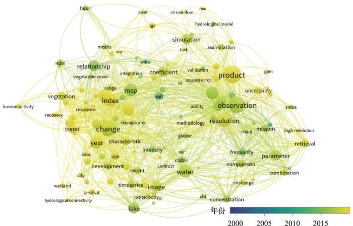
图1
1976年1月—2023年1月“Web of Science”文献数据库遥感水文研究成果聚类分析
Fig. 1
Cluster analysis map of remote sensing hydrology in the world that source from Web of Science literature database
以“遥感水文”“水文遥感”“遥感水文模型”“遥感水文反演”为关键词,采用并列搜索的方法在中国知网(CNKI)文献数据库中,共检索1980—2022年发表中文论文408篇。通过对中文论文中关键词进行聚类分析,得出中国遥感水文方面研究中关注的重点和热点,从文献关键词聚类分析可以看出,中国遥感水文相关研究具有以下3个主要特点(图2):① 遥感和水文的结合比国际上更为关注,研究对象涉及洪水预报、土壤水、地下水、河川径流、水文地质和蒸散发等;② 从发展历程上看,从单纯的遥感反演水文要素发展到遥感和水文模型的结合,进而推动遥感技术在水文研究领域的应用;遥感技术的应用将深刻改变了水文学研究方法已经成为共识,单纯的水文模型研究也越来越少;③ 目前遥感和水文的耦合还较为松散,没有将遥感提供的连续空间格网信息与产汇流动态过程实现真正的耦合;自主研发的遥感水文模型还较少,在实际应用部门推广的遥感水文模型更少。
图2
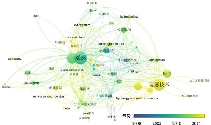
图2
1980—2022年CNKI文献数据库遥感水文研究成果聚类分析
Fig. 2
Cluster analysis map of remote sensing hydrology in China source from CNKI literature database
4 遥感水文模型是遥感水文研究重点
水文指自然界中水的各种变化和运动的现象,一个区域或流域的水量(水的多少)、水情(水的变化)和水质(水的好坏)是水文学需要回答的基本问题,水文模型是解决这些问题的主要途径。因此尽管遥感水文的研究领域包括了水文要素的遥感反演,但是从以上国内文献分析中可以看出,遥感与水文模型的耦合就一直是遥感水文研究的重点。
1973年Adelman在阐述遥感在水文中应用时,重点说明了通过遥感获取流域资料来支撑水文模型的可行性[9]。1984年胡四一从“测雨雷达联机洪水预报”和“利用卫星图片资料估算降雨量”的研究中得出“一个主要的趋势是将遥感资料并入新的水文模型作为输入,发展和改进这种基于更为广泛的资料的水文模型”[11]。张仁杰把流域划分为若干基本计算单元,建立每个基本计算单元和流域的遥感信息模型,从而证明其在无水文记录地区的径流估算是可行性[17]。熊江波利用遥感提供的流域下垫面特征信息和河网几何形态因子,建立更完善的水文模型,阐明遥感水文模型在“辽阔地域和人迹罕至地区的地表水资源和洪水估算仍有很大的应用价值”[18]。1988年Schultz整理汇总了20世纪70年代以来世界各国在遥感水文方面的研究成果,归纳出的主要进展也都是围绕遥感与水文模型结合的研究,认为遥感不仅提供了水文模型的输入数据,还提供了模型的基础参数,从而优化完善水文模型的结构;并从陆地卫星资料确定水文模型参数,以及利用NOAA序列卫星资料计算月尺度径流过程来说明遥感与水文模型耦合的实际效果[10]。1989年王燕生论证了遥感增加的物理量信息为建立水文模型创造了条件,认为对概念性水文模型作适当修改与遥感信息相匹配,从而可以实现遥感与水文模型的耦合[12]。
21世纪开始,傅国斌等从水文空间尺度,遥感信息空间分辨率,水文参数空间延拓,以及遥感技术与水文科学的结合等4个方面探讨了遥感水文的空间尺度实质,从瞬时遥感信息时间拓展和遥感信息时间分辨率两个方面分析遥感水文的时间尺度内涵,从而辩证地论证了遥感与水文模型耦合。这些论述从科学认识论方面厘清了遥感水文模型研究,推进了遥感水文模型理论研究[14]。
2002年王芳等利用遥感和地理信息系统技术实现生态的空间分区,以流域水量平衡模型为基础,量化了生态需水[19];2002年薛安等回顾了地理信息系统、模型库管理系统和空间分析处理系统集成研究的现状,提出了对象模拟模型和对象分析处理模型的元模型层次体系[20];2005年刘家宏等开展了用遥感图像提取模型分布式参数研究,并应用在黄河数字流域模型的建设实践中[21];2005年夏军提出“随着水文循环中各个组成要素的深入研究,以及计算机、地理信息系统和遥感技术的迅速发展,使构造具有一定物理基础的流域分布式水文模型成为可能,是目前水文模型的重要发展方向”[22]。随后,赵少华等结合生态环境对水资源管理的需要,从遥感与水文模型耦合的结构对遥感水文模型进行了分类[23];李新等开展了流域综合遥感联合试验,进一步创新了水文变量遥感反演与实证方法[24];杨大文等综合国内外水文学的新进展,结合遥感空间数据和大数据,实现多要素、多过程的综合模拟,提出构建“陆面—水文—社会耦合模型”[25];刘元波等阐述了流域水量平衡原理与遥感水量收支闭合,流域水量平衡要素的遥感反演及适用性检验,以及数据同化等3个方面的科学问题[26];岩腊等从中国最严格水资源管理制度出发,探索地面观测、卫星遥感和陆面同化系统三位一体的立体监测体系的构建,明确遥感与水文模型的结合是其检测体系的重要基础[27]。
5 遥感水文模型类型与开发案例
5.1 遥感水文模型的类型
应用遥感资料的水量平衡模型的结构简单而清晰,但计算存在误差累计问题。如刘昌明等举例提出,在降水量为500 mm的半湿润半干旱地区,实际蒸散发量为420 mm;由于区域蒸散量估算的困难和精度,如误差为±10%,即估算区域蒸散发量为378mm或462 mm,尚在满意程度范围内,但径流量的误差则高达±50%以上,令人无法接受[31]。
5.2 遥感水文模型平台开发案例
由于遥感水文模型的诸多不确定性,单一模型难以分析不同情形的水文过程,为此针对暴雨过程、流域过程和区域水循环过程,刘昌明等研发了EcoHAT(Ecological Hydrology Assessment Tools)遥感水文模型平台系统[35]。EcoHAT立足于遥感数据的空间特征,开展分布式水文过程和生态水文模拟,通过区域空间网格参数的输入,实现基于像元的模型运算。EcoHAT系统主要由9个遥感水文模型组成(图3),首先以河川径流监测为基础,用河川径流遥感监测模型EcoHAT RSHS解决水资源监测问题;其次构建不同尺度的水文过程模型,包括暴雨径流模型EcoHAT LCM、流域水文过程模型EcoHAT RS-DTVGM和区域水循环模型EcoHAT SVAT,以及城市雨洪模型EcoHAT Eco-rudim,从而解决水文模拟计算问题;最后构建物质迁移转化模型,包括土壤侵蚀模型EcoHAT LCM-MUSLE、非点源污染模型EcoHAT Macro-NPS、氮循环EcoHAT NT和磷素迁移转换模型EcoHAT PT。
图3
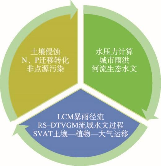
图4
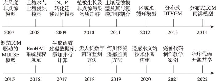
图4
EcoHAT系统发展历程
Fig. 4
The important development milestones of the EcoHAT model
图5
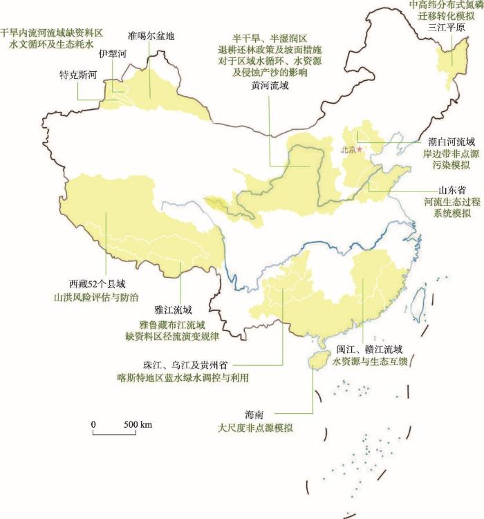
图5
EcoHAT应用区域
注:基于自然资源部标准地图服务网站GS(2016)1549号的标准地图绘制,底图边界无修改。
Fig. 5
Regions in China where the EcoHAT model is applied
6 遥感水文模型发展展望
从20世纪70年代遥感水文模型发展的成功历程,可以清楚地认识到“遥感”与“水文模型”耦合发展的辩证关系,即遥感的优势在于不与目标物相接触来探测目标特性,从而拓展了水文模型的空间参数;缺憾也正是仅通过目标物电磁波特性观测,从而产生一系列不确定性;同时还应当认识到实践对遥感水文模型建模认识的重要推动作用,正是因为遥感水文模型发展寓之于实际应用,抓住了方法技术的变革时机,吸纳了更多类型信息数据来解决遥感水文模型面临的各种难题。
水文模型终究是对现实系统的简化,由于水文系统高度的非线性特性,遥感水文模型仍然面临时空尺度、模型参数率定和模拟不确定性等难题[39]。因此,耦合多重信息采集手段,立足解决重大实际问题仍然是遥感水文模型发展的趋势。
6.1 遥感径流监测技术将有利于提升遥感水文的数据获取能力
遥感水文模型的根本目的之一就是获取河流径流量。随着遥感技术和无人机技术的发展和推广,直接监测径流的新方法不断涌现。在这些新技术中,遥感水文站是一项遥感径流监测的新兴技术,也是发展的一个重要方向。遥感水文站技术以无人机低空遥感和地面测量为基础,应用高精度无人机地形数据和实测河道水文水力参数,构建精确的三维数字河道模型,利用遥感卫星提供的水面宽度序列数据,驱动数字河道模型,计算出河道流量,时间分辨率最高可达到旬尺度,从而获取长序列河道流量数据和历史流量数据回溯,截至2022年底全国已建设监测站站点500余个[40]。通过遥感水文站新技术,将大大降低水文数据的获取成本,为水文数据进一步共享提供了技术支持[41],同时也为更好地解决水文模型不确定性问题提供坚实的观测数据基础。
6.2 地面多传感器平台与智能物联网应用将弥补遥感径流监测时间频次的不足
随着地面和低空水文监测传感器发展以及通信技术不断提升,让以流域为单元的传感器物联网建设成为现实[42],物联网通过5G网络实时将数据发送至高性能服务器,实现数据的接收、算法集成、数据处理和存储。丰富的数据资源将有效解决遥感水文模型的时空尺度、模型参数率定和模拟不确定性等问题,提高遥感水文模型可靠性。如高塔综合观测平台和流域水文传感器智能物联网能够进一步降低水文监测的成本,形成以流域为单元的水文监测体系,获取多种关键水文要素。又如塔基视频流量技术将应用高塔架设的视频监测传感器[43-44],获取河道断面监测视频数据,提取每一帧图像并计算监测断面的水面宽度数据,通过高时间分辨率的水面宽度数据,驱动高精度数字河道模型,进而获取高精度的河道流量,将弥补遥感监测径流时间频次不足和突发事件监测能力的不足。
6.3 参数不确定性分析与缺资料区应用仍然是遥感水文模型的重点问题
随着对地观测卫星数量增多,数据挖掘技术不断发展,已经形成了时空分辨率与水文模型建模尺度相匹配、准确度较高的遥感数据产品。水文模型所需降水、气温等驱动要素,以及所模拟的土壤含水量、蒸散发等重要过程变量的遥感栅格数据产品可为缺资料地区水文模型构建提供强大数据支持。随着遥感数据产品逐渐丰富,在完全无地面观测流域,可以用结构较为复杂的SWAT、VIC等分布式水文模型进行水文模拟,提升对流域水文循环过程时空演变的认识。当前遥感降水数据产品精度已经基本符合分布式水文模型建模需求[45],对于蒸散发与土壤含水量遥感数据产品,其优势是在于能够提供丰富的时空异质性信息,它们与水文模型的结合可有两种方式:① 进行参数率定,在使用遥感河道水面宽度或高程数据率定模型后,继续使用遥感蒸散发或土壤含水量数据进一步对参数空间进行约束[46];② 与模型模拟进行同化,分要素分阶段进行时序同化,通过融合遥感数据与模型模拟,提升模型模拟的精准性[47]。
6.4 流域水量—水质—水生态过程精细化模拟给遥感水文模型发展提出了更高要求
流域水文循环过程是流域内物质、能量与信息传递的重要途径。随着生态文明建设不断深入,流域生态环境保护呈现水资源、水环境与水生态三水融合管控的态势。水文模型所模拟的降雨径流过程是模拟流域内水文节律、面源与点源污染驱动下水环境与水生态过程的基础,流域水文—水环境模型发展至今,可应对流域水量—水质过程模拟[48]或地表河湖水文—水环境过程模拟[49]。但在服务流域陆水一体化管控的三水综合模拟中,现有模型仍存在水量—水质模拟与水生态模拟联动性差,从集水区到全流域跨尺度耦合中的界面条件协调性弱,模型对三水融合过程关键环节的数学表达精度低等瓶颈。利用空—天—地立体化观测技术,将流域内点状离散观测通过空—天观测进行时空拓展[50],进而捕捉水生态动态连续变化信息,从而克服三水系统中水生态模拟的短板,打通多源数据跨尺度融合链条,为模型三水融合模拟提供更为精准的驱动数据与关键参数信息,实现流域三水综合模拟模型的升级换代。
7 结论
遥感水文是水文学与遥感学的交叉研究领域,遥感水文将遥感技术与水文模型相结合,以构建遥感信息驱动的水文模型为主要特征,从20世纪70年代以来遥感水文模型就一直是遥感水文的热点。遥感水文模型可以概括为遥感信息和地面同步实测资料的回归模型,应用遥感资料的水量平衡模型,以及遥感信息作为参数的参数化模型3类。中国从遥感水文兴起之时就与国际上同步开展研究,并且在遥感水文的概念认知,遥感与水文相结合的科学认识,以及遥感水文模型的研发方面做出了诸多探索性的成果。然而由于水文系统高度的非线性特性,遥感水文模型仍然面临时空尺度、模型参数率定和模拟不确定性等难题。总结20世纪70年代以来遥感水文模型发展的经验,应当厘清“遥感”与“水文模型”耦合发展的辩证关系,认识到实践对遥感水文模型建模发展的重要推动作用。随着遥感技术、无人机技术的发展,以及地面和低空水文监测传感器、通信技术、大数据和云计算的不断推广,耦合多重信息采集手段,立足解决遥感径流监测技术、多传感器智能物联网、缺资料区水文分析和流域水量—水质—水生态过程精细化模拟等重大问题是遥感水文模型发展的趋势。
参考文献
Parameterization of air temperature in high temporal and spatial resolution from a combination of the SEVIRI and MODIS instruments
DOI:10.1016/j.isprsjprs.2009.02.006 URL [本文引用: 1]
Precipitation: Measurement, remote sensing, climatology and modeling
DOI:10.1016/j.atmosres.2009.08.017 URL [本文引用: 1]
Glacier melt: A review on processes and their modelling
DOI:10.1191/0309133305pp453ra
URL
[本文引用: 1]

Modelling ice and snow melt is of large practical and scientific interest, including issues such as water resource management, avalanche forecasting, glacier dynamics, hydrology and hydrochemistry, as well as the response of glaciers to climate change. During the last few decades, a large variety of melt models have been developed, ranging from simple temperature-index to sophisticated energy-balance models. There is a recent trend towards modelling with both high temporal and spatial resolution, the latter accomplished by fully distributed models. This review discusses the relevant processes at the surface-atmosphere interface, and their representation in melt models. Despite considerable advances in distributed melt modelling there is still a need to refine and develop models with high spatial and temporal resolution based on moderate input data requirements. While modelling of incoming radiation in mountain terrain is relatively accurate, modelling of turbulent fluxes and spatial and temporal variability in albedo constitute major uncertainties in current energy-balance melt models, and thus need further research.
Validation of a large scale hydrological model with data fields retrieved from reflective and thermal optical remote sensing data: A case study for the Upper Rhine Valley
Hydrological consistency using multi-sensor remote sensing data for water and energy cycle studies
DOI:10.1016/j.rse.2007.03.027 URL [本文引用: 1]
Assimilation of remotely sensed latent heat flux in a distributed hydrological model
DOI:10.1016/S0309-1708(02)00089-1 URL [本文引用: 1]
A remote sensing driven distributed hydrological model of the Senegal River basin
DOI:10.1016/j.jhydrol.2008.03.006 URL [本文引用: 1]
Developments in Applications of Remote Sensing to Hydrology
Remote sensing in hydrology
DOI:10.1016/0022-1694(88)90187-4 URL [本文引用: 2]
Introduction to the application of remote sensing technology in hydrology and water resources in the Federal Republic of Germany
德意志联邦共和国遥感技术在水文和水资源中的应用介绍
Remote sensing hydrological models and applications
遥感水文模型及其应用
Potentiality of remote sensing for hydrology in the new generation
新一代水文遥感潜力展望
Scale issues on the applications of remote sensing to hydrology
遥感水文应用中的尺度问题
DOI:10.11867/j.issn.1001-8166.2001.06.0755
[本文引用: 2]
遥感技术在水文科学中的广泛应用,极大地拓宽了其研究的领域和范围,增加了其研究的深度。但同时也应该看到,遥感信息的空间分辨率和时间分辨率,以及水文科学自身尺度问题的复杂性,一方面对遥感水文的应用产生困难和问题,限制了水文遥感的应用;另一方面又对水文尺度问题提供了新的技术手段,为遥感水文应用增添了新的亮点。从水文机理与空间尺度、遥感信息的空间分辨率、水文参数的空间延拓,以及遥感技术与水文科学的发展等 4个方面探讨了遥感水文的空间尺度问题;从瞬时遥感信息的时间拓展和遥感信息的时间分辨率 2个方面讨论了遥感水文的时间尺度问题。
Advance of hydrographic remote sensing with time
与时俱进的水利遥感
From remote sensing information to hydrological model parameters
从遥感信息到水文模型参数
Methods of determining parameters of hydrologic model through remotely sensed data
用遥感资料确定水文模型参数的方法
A study of ecological water requirements in Northwest China (Part Ⅱ): Application of remote sensing and GIS.
中国西北地区生态需水研究(2): 基于遥感和地理信息系统技术的区域生态需水计算及分析
Integration theory of model and GIS
模型与GIS集成理论初步研究
Study on key technology of digital river basin model
数字流域模型关键技术研究
Advances in international hydrological science research
国际水文科学研究的新进展
DOI:10.11867/j.issn.1001-8166.2006.03.0256
[本文引用: 1]
在介绍第七届国际水文科学大会关注热点问题的基础上,总结了近4年来国际水文科学研究的新进展,主要包括:无资料流域水文预测,不确定性、非线性和尺度问题,生态水文学,水文模型及资料获取与参数识别,气候变化的水文响应,水资源可持续利用,城市水文水资源,同位素技术和遥感技术在水文学中应用;提出未来水文学研究的展望。
Advances in the coupled model of remote sensing and hydrology
遥感水文耦合模型的研究进展
The progresses on the Watershed Allied Telemetry Experimental Research(WATER): Remote sensing of key hydrological and ecological parameters
黑河综合遥感联合试验研究进展: 水文与生态参量遥感反演与估算
Progress and prospect of hydrological sciences
DOI:10.18306/dlkxjz.2018.01.005
[本文引用: 1]
Hydrology is the science that describes the continuous movement of water, the related biogeochemical and geophysical processes, and their interactions with the environment. Hydrology research has evolved from experience-based to theories, from single process to complex systems, and from qualitative interpretations to quantitative models. The progress and evolution of hydrology has been intimately intertwined with the scientific and technological progresses and socioeconomic development, which creates many branches and interdisciplinary areas of hydrology, such as ecohydrology, hydrometeorology, cryosphere hydrology, hydrologic remote sensing, isotope hydrology, urban hydrology, and socio-hydrology. Hydrology research has made notable progress in the fields of multi-scale observations, coupled land surface-hydrology-society modeling, and multi-source data and model assimilation techniques, which further expands the connotation of hydrological study. In the future, hydrology research will focus on the characteristics and mechanism of the changes of water cycle, prediction of the changes of water cycle, and natural and social impact assessment of the changes of water cycle, in order to offer sustainable solutions to water security. In summary, the research paradigm of hydrology would shift from the traditionally self-focused approaches to the emerging integrated approaches that focus on all the water-related processes across multiple scales and sectors in the earth system.
水文学研究进展与展望
DOI:10.18306/dlkxjz.2018.01.005
[本文引用: 1]
水文学是研究地球上水的起源、存在、分布、循环运动等变化规律,并运用这些规律为人类服务的知识体系。水文学研究经历了由经验到理论、由简单过程到复杂系统、由定性描述到定量模拟的发展历程,其学科体系演进与科学技术进步及社会发展需求紧密联系,并由此衍生出诸如生态水文学、气象水文学、冰冻圈水文学、遥感水文学、同位素水文学、城市水文学、社会水文学等多种交叉研究领域与分支学科。当今水文学研究在水文多尺度观测、陆面—水文—社会耦合模拟及多源观测—模型同化技术等领域取得显著进展,水文学研究的广度和深度不断拓展。未来水文学研究将面向陆地水文循环的变化规律及其效应,重点关注水文循环变化特征和机理、水文循环变化趋势预估及水文循环变化的自然和社会影响等前沿课题;从原有就水论水研究思路转向在自然地理综合分析框架下以水循环为纽带开展的多尺度、多过程集成研究。
Remote sensing for watershed hydrology: Issues and challenges
流域水文遥感的科学问题与挑战
DOI:10.11867/j.issn.1001-8166.2020.045
[本文引用: 1]
21世纪以来,水文遥感得到长足发展并成为当前地球科学的研究热点之一,同时也在流域生态水文过程研究中发挥了不可替代的作用,成为当前流域生态水文研究的重要手段。流域水文遥感在研究内容、研究方法、实际应用等方面具有流域整体性要求,涉及流域水量收支的闭合约束、要素反演检验的流域有效性以及流域水文模型的数据同化,指出流域尺度的反演检验、反演结果的不确定性和数据同化的误差溯源是当前面临的科学挑战。
A review on water resources stereoscopic monitoring systems based on multi source data
基于多源信息的水资源立体监测研究综述
Dynamics of surface water area in the Yellow River Basin and its influencing mechanism during 1986-2019 based on Google Earth Engine
DOI:10.11821/dlxb202205008
[本文引用: 1]
The Yellow River Basin (YRB) has been facing severe water shortages, hence the monitoring of long-term dynamics of surface water area (SWA) is essential to better understand the spatial and temporal variation of surface water resources and its driving factors. In this study, the spatial and temporal change characteristics of SWA in the YRB were revealed, and then the impacts and relative impact rate of precipitation (Pre), temperature (Temp), leaf area index (LAI), SWA in the previous year (Pre_SWA) and residual factors (e.g. water conservation measures and human water use activities) on SWA were determined in the combination of water detection index, linear slope, multiple linear regression and partial differential decomposition. The results show that: (1) the overall accuracy of classification of surface water bodies is 97%. The increase rate of year-long SWA in the study area from 1986 to 2019 is 49.82 km2/a, of which 83.2% was contributed by the SWA increment from the main river channel area, and the year 2001 is the turning point of SWA trend from decreasing to increasing; the seasonal SWA decreased at a rate of -79.2 km2/a, of which 61.8% was contributed by the SWA decrease in the sub-basin areas. (2) The SWA changes of all major natural lakes are relatively stable, and the only decreasing trend of SWA was observed in the Hongjiannao lake; the SWA of Xiaolangdi and Longyangxia reservoirs changed significantly with an increasing trend among the large reservoirs in the main river channel, and SWA increasing trends can be observed in the 50 sub-basins located in the middle and lower reaches. (3) Precipitation had the least effect on the increasing trend of SWA, and warming caused a decrease of SWA in the middle reaches, but led to an increase of SWA in the source area. The impacts of vegetation greening on the SWA trend in the main channel area and sub-basin areas are 10.12 km2/a and 7.26 km2/a, respectively. Residual factors had a negative reffect on the SWA trend in the sub-basin areas, where the SWA reduction induced by human water use was much greater than the SWA increment induced by small water conservancy projects. However, residual factors had a positive effect on the SWA increase due to the great regulating storage capacity of large reservoirs in the main river channel area.
1986—2019年黄河流域地表水体动态变化及其影响因素
DOI:10.11821/dlxb202205008
[本文引用: 1]
黄河流域水资源严重短缺,对地表水面积(SWA)开展动态监测有助于明晰地表水资源时空变化规律及其驱动机制。本文基于Google Earth Engine云平台技术,综合利用混合指数规则集、线性斜率、多元线性回归和偏微分分解等方法,揭示了黄河流域SWA的年际变化及其空间分异规律,厘定了降雨、温度、植被叶面积指数、前一年SWA和水利水保措施与人类用水活动等其他因素对SWA的影响量和相对影响率。结果表明:① 地表水体总体识别精度为97%。1986—2019年全流域永久性SWA年际增长速率49.82 km<sup>2</sup>/a,其中主河道区贡献83.2%,且2001年为SWA变化由减小到增加的转折点;季节性SWA年际减小速率-79.2 km<sup>2</sup>/a,其中子流域区贡献61.8%。② 除红碱淖SWA呈显著持续减小外,其他主要天然湖泊SWA均较为稳定;6个主河道大型水库中,小浪底和龙羊峡水库SWA增加趋势最为显著;在86个子流域中,50个子流域SWA呈增加趋势,主要分布于流域中下游。③ 非气象要素对SWA的影响均大于气象要素影响作用。降雨对SWA的增加作用最小,温度上升造成中游地区SWA减小,但却导致源区SWA增加。植被叶面积指数增加导致主河道区和子流域区SWA变化斜率分别增加10.12 km<sup>2</sup>/a和7.26 km<sup>2</sup>/a。其他因素对子流域区SWA增加呈负作用,这表明子流域内剧烈用水活动对SWA的减小作用大于水利水保措施对SWA的增加作用,但是分布于主河道中的大型梯级水库调蓄功能可显著提升其对主河道区SWA的增加作用。
Use of multispectral photography in water resources planning and management in North Carolina
Evaluation of daily evapotranspiration estimates from instantaneous measurements
DOI:10.1016/0168-1923(94)02181-I URL [本文引用: 1]
A discussion on some issues of hydro-geographical research
DOI:10.11821/dlxb202201001
[本文引用: 1]
Water-related issues have long been one of the most important topics in China, and these issues are related to a series of major national requirements, including social stability, people's livelihood and welfare, and economic development. Hydro-geography is an interdisciplinary subject of hydrology and geography that adopts the principles, perspective and methodologies of geography. The theory of the terrestrial surface system has an important enlightening effect on the systematic research of hydro-geography. First, this study discusses the cross-relationship and research content in hydro-geography, as well as the rise of research on global water systems and the ecohydrology. After summarizing the main advocates of terrestrial surface system theory and their viewpoints, this study explores the relationship between the comprehensive and regional aspects of geographic research, while proposing that the "three characteristics" (i.e., comprehensive, regional and orderly characteristics of processes) should be the research thought for hydro-geographical system. Furthermore, based on the expansion of the basic theories of the subject, this study presents several cases of systems science and technology that can deepen the spatiotemporal dynamic process mechanism (orderliness) of hydro-geography. Finally, several key development and research directions of hydro-geographic research in China are discussed, mainly including: research on the impact of climate change and impacts of human activities on the water cycle process; research on the dynamic evolution mechanism of the four major balances in ecohydrology; research on renewability of water resources; the process of evapotranspiration of plants (crops) and water-saving control; hydro-geographic zoning, mapping technology and intelligence technology applications.
水文地理研究发展若干问题商榷
DOI:10.11821/dlxb202201001
[本文引用: 1]
水问题研究一直是我们国家最重要的课题之一,关系到社会稳定、民生福祉、经济发展等一系列国家重大需求。水文地理是水文学与地理学交叉学科,主要采用地理学原理、观点和方法。陆地表层系统的提出对水文地理的系统性研究具有重要的启发作用。首先,对水文地理学的交叉关联、研究内容、全球水系统和生态水文研究的兴起进行阐述;其次,在总结陆地表层系统论思想的主要倡导者及其观点后,讨论了地理研究综合性和区域性的关系,提出综合性、区域性和时空动态过程机理等“三性”应是水文地理系统的研究思想;再次,基于学科基础理论的扩展,给出深化水文地理时空动态过程机理的系统科学技术的几个案例;最后,讨论了中国水文地理研究的几个重点发展方向,主要包括气候变化与人类活动对水循环过程的影响、生态水文四大平衡动态演变过程机理、水资源可再生性维护、“蓝绿水”的认知意义、水文地理区划与制图技术及智能技术等。
Hydrologic land use classification using Landsat
Application of remote sensing images to dynamic hydrologic simulation
遥感信息在水文动态模拟中的应用
A dynamic precipitation-runoff model for a watershed based on grid data
DOI:10.11821/xb199503009
[本文引用: 1]
After having studied the precipitation-runoff process affected by the spatial and temporal variability of precipitation and the spatial differences of physi-geographic parameters on the earth’s surface, this paper developed a dynamic model based on grid data. The model takes topographic map.soil distribution map. land use map. precipitation. evaporation. seepage and moisture content of soils as inputs. The hydrological grid data base is supported by the Geographic Information System (GIS). XMGIS 2. 0, which is made by the authors. According to the model, necessary analyses of digital topographic model and grid superposition are made, and the grid element assigned grade and flow forms a fully watershed (Fig. 2).When the runoff yield and the inflow of surface and subsurface. taking the grid element as a unit. are respectively calculated. the outflow of a grid element is one of inflows in the corresponding subgrid. All the grid element is continuously calculated in the order of grade, and the flow process in every time interval is finally obtained.
基于栅格数据的流域降雨径流模型
DOI:10.11821/xb199503009
[本文引用: 1]
本文在研究降雨时空分布不均匀与下垫面自然地理参数空间分布不均匀,对降雨径流过程影响的基础上,提出了一种在地理信息系统支持下的动态分布式降雨径流流域模型,实现了基于栅格的坡面产汇流与河道汇流的数值模拟,能够获得流域上任意模拟时刻任意栅格的径流量。模型视栅格为水文一致性单元,水文参数在栅格内一致,在相邻栅格间变化。采用Holtan模型计算下渗率,水量平衡方程和线性水库的马斯京根法进行栅格产汇流演算,模型的每个参数具有明确的物理意义和地理规律,本文的产汇流模拟方法以石桥铺径流实验区作为验证,取得较好效果。
Development and application of distributed ecological hydrology model: Ecohydrological Assessment Tool (EcoHAT) system
分布式生态水文模型EcoHAT系统开发及应用
A distributed hydrological model driven by multi-source spatial data and its application in the Ili River Basin of Central Asia
DOI:10.1007/s11269-014-0641-z URL [本文引用: 1]
Quantifying anthropogenic and climatic impacts on sediment load in the sediment-rich region of the Chinese Loess Plateau by coupling a hydrological model and ANN
DOI:10.1007/s00477-017-1381-4 URL [本文引用: 1]
The assessment of the changes of biomass and riparian buffer width in the terminal reservoir under the impact of the South-to-North Water Diversion Project in China
DOI:10.1016/j.ecolind.2017.11.011 URL [本文引用: 1]
Hydrological models: Past, present and future
水文模型: 回顾与展望
Discharge estimation with hydraulic geometry using unmanned aerial vehicle and remote sensing
星—机一体的水力几何形态流量估算方法
A new method for long-term river discharge estimation of small and medium-scale rivers by using multisource remote sensing and RSHS: Application and validation
River discharge is an important hydrological parameter of river water resources. Especially in small- and medium-scale rivers, data deficiency is the biggest problem for studies of river discharge. In recent years, remote sensing has become a rapid and convenient method to estimate river discharge. However, remote sensing images still have some difficulty generating continuous long-term river discharge. To address this problem, we developed a new method coupling the remote sensing hydrology station method (RSHS) with statistical regression downscaling, using data from optical satellites (Landsat-8, Sentinel-2), radar satellites (Sentinel-1), and un-manned aerial vehicles (UAVs). We applied this method to monitor monthly river discharge for small- and medium-scale rivers from 2016 to 2020 on Yunnan-Guizhou Plateau and evaluated the accuracy of the results. The results show that (1) by applying the newly constructed method, the water body continuity index obtained by Landsat-8 increased by 7% and the average river length percentage in the channel reached 90.7%, a 40% increase; (2) there were only 10 river flow data points, on average, in the 5-year period obtained before this method was applied; after this method was applied, more than 50 river flow data points could be obtained, on average, extending the quantity of data fivefold; in addition, improper extreme values could also be avoided; (3) with better continuity of water body distribution, the images provided steadier river widths. The relative error of daily flow estimation from Landsat-8 images was reduced by 60% and the mean percentage error was reduced by one-fourth. The relative error of the multisource remote sensing composited flow was reduced by 37% with a reduction in the mean percentage error of over a half; (4) in addition, we found that when the threshold difference between water bodies and land in remote sensing images is more than 0.2, the impact of water body recognition error on flow accuracy can be ignored. This method helps to overcome the absence of remote sensing methods for the long-term estimation of flow series in small- and medium-scale rivers, improves the accuracy of remote sensing methods for calculating flow, and provides ideas for regional water resource management and utilization.
Application of remote sensing technology in the construction of digital twin river basins
遥感技术在数字孪生流域建设中的应用
Research on the method and application of large-scale ecological disturbance risk assessment
大尺度生态干扰风险评估技术方法及应用研究
Spatial analysis on diffuse pollution and algal bloom characteristic with remote sensing in Chao Lake Basin
巢湖流域氮磷面源污染与水华空间分布遥感解析
Simulation of actual runoff using remote sensing driven distributed hydrological model
遥感驱动的分布式实际径流模拟研究
On the contribution of remote sensing-based calibration to model hydrological and hydraulic processes in tropical regions
Multi-mission satellite remote sensing data for improving land hydrological models via data assimilation
Satellite remote sensing offers valuable tools to study Earth and hydrological processes and improve land surface models. This is essential to improve the quality of model predictions, which are affected by various factors such as erroneous input data, the uncertainty of model forcings, and parameter uncertainties. Abundant datasets from multi-mission satellite remote sensing during recent years have provided an opportunity to improve not only the model estimates but also model parameters through a parameter estimation process. This study utilises multiple datasets from satellite remote sensing including soil moisture from Soil Moisture and Ocean Salinity Mission and Advanced Microwave Scanning Radiometer Earth Observing System, terrestrial water storage from the Gravity Recovery And Climate Experiment, and leaf area index from Advanced Very-High-Resolution Radiometer to estimate model parameters. This is done using the recently proposed assimilation method, unsupervised weak constrained ensemble Kalman filter (UWCEnKF). UWCEnKF applies a dual scheme to separately update the state and parameters using two interactive EnKF filters followed by a water balance constraint enforcement. The performance of multivariate data assimilation is evaluated against various independent data over different time periods over two different basins including the Murray-Darling and Mississippi basins. Results indicate that simultaneous assimilation of multiple satellite products combined with parameter estimation strongly improves model predictions compared with single satellite products and/or state estimation alone. This improvement is achieved not only during the parameter estimation period ([Formula: see text] 32% groundwater RMSE reduction and soil moisture correlation increase from [Formula: see text] 0.66 to [Formula: see text] 0.85) but also during the forecast period ([Formula: see text] 14% groundwater RMSE reduction and soil moisture correlation increase from [Formula: see text] 0.69 to [Formula: see text] 0.78) due to the effective impacts of the approach on both state and parameters.
Evaluating the influence of hydrological condition on the phosphorus loads in an agricultural river basin using the SWAT model
DOI:10.2166/nh.2021.165
URL
[本文引用: 1]
Excessive phosphorus is an important cause of eutrophication. For river basin management, source identification and control of nonpoint source (NPS) pollution are difficult. In this study, to explore influences of hydrological conditions on phosphorus, the Soil and Water Assessment Tool (SWAT) model is applied to the Luanhe River basin in North China. Moreover, influences of the spatial scale of the livestock and poultry amount data on estimations of phosphorus loads are also discussed. The results show that applying town-level livestock and poultry amount data allows the model to perform better when estimating phosphorus loads, indicating that using data at a finer administrative level is necessary. For the typical wet year, the estimated annual phosphorus load was 2.6 times that in the typical dry year. Meanwhile, the contribution of pollution in summer to the annual load is greater in the wet year than that in the dry year. The spatial distributions of subbasins with high unit loads of phosphorus differ under different hydrological conditions, meaning that critical areas for pollution control vary with the wetness of each year. All these findings indicate that for pollution control at basin scale, considering the seasonal and interannual variabilities in hydrological conditions is highly demanded.
Diverse responses of hydrodynamics, nutrients and algal biomass to water diversion in a eutrophic shallow lake
Monitoring inland water quality using remote sensing: Potential and limitations of spectral indices, bio-optical simulations, machine learning, and cloud computing
