

1 引言
旅游作为新兴的重要发展力量,正深刻改变着乡村空间格局。随着旅游快速发展和乡村振兴战略的推进,乡村旅游地正面临由单一农业功能向多功能转变的局面[1]。乡村承载人居保障、农业生产等传统功能的同时,旅游消费赋予乡村发展新动能和新活力,生态保护、旅游休闲等潜在功能被逐步挖掘,由此导致乡村旅游地土地利用方式变更、资源要素重新配置和空间重组。然而随着人类旅游活动影响范围和强度的增加,乡村空间资源更为稀缺,人地关系变化愈加剧烈,并引发人居空间功能失衡、土地利用效率下降、生态环境风险增加等诸多问题,乡村旅游地正成为利益主体直接对话和冲突的场所。分析和认识乡村旅游地人类活动与地理环境之间的冲突关系,对利害关系进行协调,是解决人地矛盾问题、实现乡村旅游地可持续发展的重要途径[2]。
多功能源自人类自身的复杂性与矛盾性,反映区域空间能满足人类多种需求的程度和能力[3]。多功能概念最早于1992年联合国“环境与发展”地球峰会上提出[4]。目前,在人本主义及后现代主义思潮的影响[5⇓-7]下,多功能正成为乡村地理学、旅游地理学、社会学等学科研究热点[8⇓-10],且取得较多重要研究成果[11⇓-13]。随着多功能理论的发展,乡村空间嵌入了多功能概念,反映了社会发展过程中人类对乡村地域生产、消费和生态等多元功能的需求变化驱动着乡村功能不断演变[11,14]。后生产主义范式下的乡村地区被视为消费空间,土地多功能逐渐取代农业多功能,成为乡村多功能转型的重要载体[15-16]。上述研究成果更多以物质空间为切入点,解构、重构乡村空间多功能,强调“自上而下”传统研究范式。当前,随着乡村多元力量的涌现,利益主体功能需求成为推动乡村多功能转型的关键,“自下而上”为主要特征的研究范式在乡村多功能研究中日益受到关注。国内外学者开始关注利益主体需求在多功能转型及多功能权衡中所扮演的重要角色,不同利益主体基于不同的目标或价值观而认知,对乡村旅游地土地功能提出更多需求[17],导致空间层面与社会层面冲突与矛盾的出现[18⇓⇓⇓-22]。解决冲突的关键不在于避免冲突本身,而在于冲突的协调和管理[23-24]。通过关注不同利益主体多功能诉求[25-26],寻求多功能协调机制[27⇓-29],找出调节冲突的方法以缓解空间冲突[18]。现有研究主要聚焦利益主体冲突的属性特征,较少关注利益主体的空间认知价值,乡村旅游地利益主体多功能空间认知冲突有待深入研究,多功能空间认知冲突因素和协调机制仍需深入解释。研究方法上,有待进一步发挥地理学采集数据和描述多功能空间认知等方面的学科优势。
面对乡村振兴的迫切现实需求和国家赋予的更高生态保护战略使命,亟需科学判识新阶段变化环境下(生态保护约束、旅游转型发展等)的乡村旅游地利益主体多功能空间诉求问题。如何描述、量化和映射不同利益主体多功能空间认知冲突?多功能空间认知冲突呈现哪些特征?如何解释资源竞争带来的多功能空间认知冲突产生“为什么”的内源性问题?如何建构冲突的协调机制和有效协调路径?开展这些基础性理论问题的科学研究,既是旅游地理学领域亟待深入研究的重要课题,也是新阶段面向国家战略需求亟需推进科学决策的重要研究主题。鉴于此,本文基于地理学的空间认知视角,以黄山风景区山岔村为案例,采取“自下而上”的研究范式,尝试构建乡村旅游地利益主体多功能空间认知“冲突—协调”理论框架,探究二者之间的内在关联机制;通过密度制图和冲突倾向模型等方法,科学识别利益主体多功能诉求和空间认知的潜在冲突点;运用扎根理论分析访谈文本,提取空间认知冲突影响因素,构建协调发展指标体系;并使用决策实验室分析法(DEMATEL)对多功能诉求的协调发展状态进行判断,提出具体协调路径。力求丰富旅游地理学理论与方法体系,为乡村旅游地利益主体协调和冲突管控、空间资源合理利用与科学管理提供支撑。
2 理论框架
2.1 乡村旅游地利益主体多功能空间认知“冲突—协调”理论研究框架
多功能空间认知冲突是空间认知差异和多元利益主体关系错综交织的结果,空间认知冲突的协调是乡村旅游地多功能空间有序重塑的重要途径。由于土地利用多宜性和主体需求多样性[30-31],多功能性成为乡村旅游地发展的核心动力[32],多功能理论为乡村旅游地可持续发展研究提供了新理论与新范式。乡村空间的多功能认知是主体以价值理念为基础,对客观功能空间进行差异性主观识别,具体表现为对农业、经济、人居保障、生态以及旅游休闲等多功能的不同认知状态和水平[10,33 -34],这些多功能认知对象和认知程度差异是功能空间认知矛盾产生的关键前因。利益相关者的参与是乡村旅游地发展成功的关键。基于利益相关者理论,乡村旅游地空间重构与多元利益主体关系重组之间存在动态的互馈关系,协调稳定的利益主体关系有助于优化乡村旅游地多功能空间格局,是旅游地可持续发展的重要保障。由此,将多功能理论与利益相关者理论相结合,聚焦地理学空间认知,构建出乡村旅游地利益主体多功能空间认知“冲突—协调”理论研究框架(图1)。
图1

图1
乡村旅游地利益主体多功能空间认知“冲突—协调”理论研究框架
Fig. 1
A theoretical research framework of multifunctional space cognition "conflict-coordination" for stakeholders in rural tourism destinations
乡村旅游地是用地结构和人类活动互动关联的空间载体[35-36],具有空间多功能复合性、用地结构异质性等特征[37],通过人为或自然过程提供多样的服务,继而经由消费满足人类的多功能需求。据此,将乡村旅游地多功能类型划分为农业、经济、人居保障、生态和旅游休闲五大功能。农业功能反映农业生产活动为地域提供农产品的能力,经济功能指为乡村人口创造财富而发挥作用的能力,人居保障功能则包括提供居住空间和生活服务两方面的能力,生态功能指具有调节气候、净化空气、水土保持以及提供生态产品与服务的能力,旅游休闲功能指为游客提供游览、体验等娱乐休闲服务的能力。受多功能需求的驱动,利益主体通过各种方式影响乡村旅游地,并最终影响各主体利益诉求的实现和乡村旅游地可持续发展。具体而言,乡村空间的地域差异性导致不同利益主体获得服务的惠益分配与消费存在偏差,利益主体以价值理念为基础认识自己赖以生存的多功能空间,且认知态度不尽相同,存在空间非一致性。地理空间认知是地理空间信息的知识化过程[38],利益主体将自身对赖以生存的环境认识转换为对现实的理解和态度,由利益主体的价值观差异而产生的理解和态度差异是空间冲突的根源[19]。通过结合功能现状与利益主体的多功能预期,识别空间资源竞争带来的功能冲突区域,采用潜在冲突倾向概念模型[39],用土地使用偏好(支持或反对)态度差异性反映社会冲突。地图是主体认知地理空间的重要表达工具[40],利益主体借助地图表达自身的土地使用偏好,多类冲突点由此衍生。在分析冲突点表征的过程中发现,利益诉求是乡村多功能空间认知冲突的本质[30,41]。多功能冲突因素直接解释多功能冲突产生原因,通过对利益诉求协调发展状态进行判别,缓解、调和矛盾与冲突。从功能导向、主体需求和生态制约等方面,确定濒临失调、轻度协调、中度协调、优质协调类型,规范现实乡村空间的发展方向。以多数人利益或整体利益为标准[42],满足利益主体多功能需求是乡村旅游地冲突协调决策的最终目标,协调稳定的利益主体关系结构是旅游地运作、管理的基本保障[43]。利益主体空间认知“冲突—协调”是循环迭代的过程,态度作为中介变量,协调多功能空间认知冲突,重塑利益主体的空间思维。此过程中所揭示的信息为处于“弱势”地位的利益主体获取话语权,为不同观点表达与整合提供支撑。
2.2 乡村旅游地利益主体多功能空间认知“冲突—协调”内在关联机制
基于“冲突—协调”理论研究框架,利益主体多功能空间认知的“冲突—协调”内在关联机制表现在驱动层面的多功能供需差异、冲突层面的多功能空间认知冲突、协调层面的多功能诉求协调路径(图2)。① 从驱动层面看,城市居民对乡村文化与环境的需求转变为旅游活动,为后生产主义消费创造了更广阔的市场,引起不同利益主体的积极响应[44]。利益主体基于各自目的对空间具有不同认知,并在土地利用方式上呈现[45]。乡村土地利用方式日益多元化,各类型用地分别提供了农业、经济、人居保障、生态和旅游休闲功能,地域功能的多样化供给也逐渐明显[14]。居民、企业、政府作为乡村旅游发展中参与程度最高的核心利益主体[46],代表不同的立场,分别从个人发展、经济利益、社会整体效益的角度出发,对生活、生产、生态都具有综合性的需求。旅游市场的多样化转型,利益主体需求的不断变化与乡村多功能发展互不同步[30],决定了乡村多功能供需一直处在动态变化中。② 从冲突层面看,空间认知冲突是利益主体基于不同利益诉求对多功能空间认知差异所产生的。政府从社会整体效益出发,对土地具有较为综合性的认知,通过政策引导等方式驱动多功能转型。企业从经济利益出发,旅游市场需求增加决定了企业对乡村商品化功能需求的不断增长。无节制的商业扩张可能导致政府作用在市场中失效,以及对社区居民的剥削。居民从个人发展出发,对乡村人居、生态环境具有基本需求,可能与政府和旅游企业的认知存在差异,进而导致空间冲突的产生。当空间功能与发展需求不相匹配时,又会造成这些主体之间矛盾与冲突,从而危及乡村旅游地可持续发展。③ 从协调层面看,考虑到各主体的利益,将其观点和利益结合起来从长远减少冲突。随着利益主体之间达成共识,合作与妥协的可能性也随之增加[47]。依据利益主体空间认知冲突表现,识别其利益诉求的协调发展状态,寻求冲突的协调机制,通过对各主体的利益进行分配、补偿和保障,促进乡村旅游地多功能空间协调有序发展。
图2
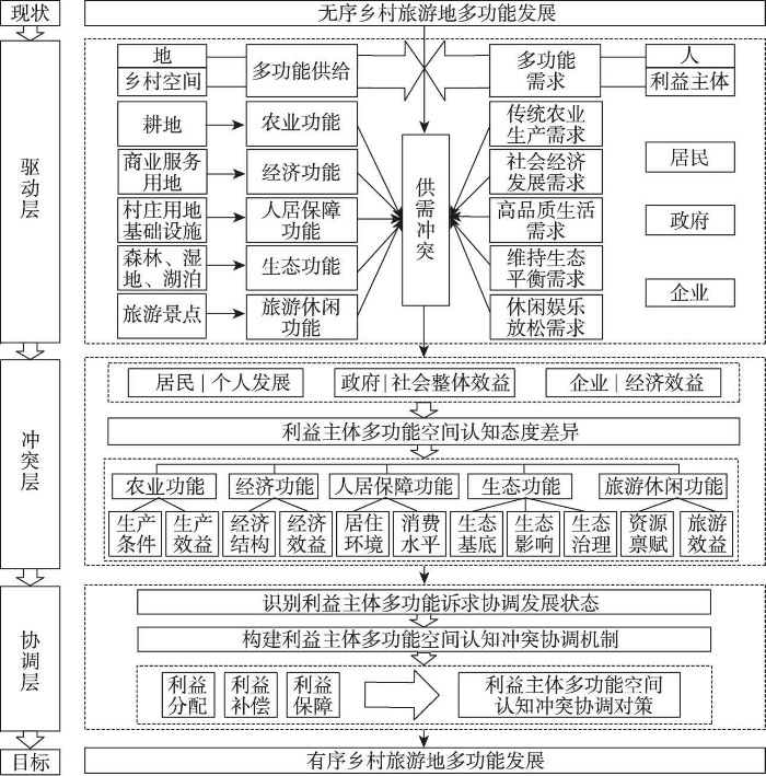
图2
乡村旅游地利益主体多功能空间认知“冲突—协调”内在关联机制
Fig. 2
The "conflict-coordination" intrinsic correlation mechanism of multifunctional spatial cognition of stakeholders in rural tourism destinations
3 研究区概况、研究方法与数据来源
3.1 研究区概况
黄山风景区是世界文化与自然遗产,拥有重要的保护价值和丰富的旅游价值。山岔村位于黄山风景区东南麓的汤口镇,北接黄山风景区,南至汤口镇中心,面积约32 km2,国道G205贯穿全境(图3)。2019年接待游客248万人次,旅游综合收入1亿元,全村75%以上的劳动力从事旅游服务,人均纯收入达22000元,村集体经济经营性收入为245万元,是“安徽省百家生态村”与“全国旅游重点村”。随着案例地旅游发展趋于成熟,空间资源稀缺性突出,人地关系矛盾加剧。旅游发展、遗产地保护与乡村可持续发展,构成了山岔村多元利益主体交织的空间利用冲突局面。
图3

山岔村农业功能方面,农用地占总面积的6.59%,以水田、旱地、茶园为主。经济功能方面,凭借旅游业带动了相关产业的发展,景区附近的翡翠新村和天湖新村发展较好。人居保障功能方面,用地占总面积的1.67%,以村庄用地和公路用地为主,13个村民组主要分布于交通干线沿线,人均住房面积为43 m2。生态功能方面,用地占总面积的87.18%,全村严禁天然林采伐,实施封山育林、退耕还林政策,森林覆盖率达97%。旅游休闲功能方面,村内拥有翡翠谷(位于上张村民组)、九龙瀑(位于田段和苦竹溪村民组)、凤凰源(位于乌泥关村民组)、香溪(位于杨家坪村民组)和天湖(位于天湖新村)景区,其中翡翠谷与凤凰源为国家4A级景区。
3.2 研究方法
3.2.1 认知冲突识别分析方法
式中:Ps指某一栅格中“对多功能分布满意”的密度值;Po指某一栅格中“对多功能分布不满意”的密度值;Ps+o表示满意和不满意的密度之和,即总体态度强度;Vc指多功能类型的密度值,也能反映地点的重要性;
(3)扎根理论。借助NVivo 12软件对访谈文本进行词频分析,筛选出不同利益主体满意和不满意的文本片段并进行编码,进而得出利益主体功能诉求的影响因素,反映多功能冲突背后的主要供需矛盾,为协调路径实施提供支撑。
3.2.2 冲突协调机制分析方法
表1 0~5标度法评分表
Tab. 1
| 影响程度 | 分数 |
|---|---|
| 没有直接影响(p>0.1) | 0 |
| 弱的直接影响(p ≤ 0.1且0 ≤ x<0.2) | 1 |
| 中等的直接影响(p ≤ 0.1且0.2 ≤ x<0.4) | 2 |
| 较强的直接影响(p ≤ 0.1且0.4 ≤ x<0.6) | 3 |
| 中强的直接影响(p ≤ 0.1且0.6 ≤ x<0.8) | 4 |
| 极强的直接影响(p ≤ 0.1且0.8 ≤ x<1) | 5 |
式中:zij为影响因素i对影响因素j的影响作用强度所对应的分数;为突出其他因素对某个因素的影响,若i = j,则zij = 0。计算标准化直接影响系数gij,得出规范化直接影响矩阵
影响度和被影响度的计算公式为:
式中:影响度Dj表示第j个影响因素对其他影响因素的直接影响和间接影响程度的大小;被影响度Ri表示第i个因素对其他因素的直接影响和间接影响程度的大小;中心度Pi表示该因素在所有因素中发挥作用的大小,中心度越大,说明该因素在多功能协调发展系统中所起的作用越大;原因度Ei > 0,称为原因度因素,该因素对其他因素存在影响作用;如果原因度Ei < 0,称为结果因素,说明该因素受其他因素的影响。
四象限法根据影响因素中心度和原因度取值分布来确定影响山岔村利益主体多功能诉求的协调发展状态。以中心度为横坐标,原因度为纵坐标,绘制分布图,交点O(a, 0)为横纵坐标的交点(a到中心度最大值和最小值的距离相等)。第一象限为濒临失调,建议重新进行规划,全面优化设计;第二象限为轻度协调,建议迅速采取行动,避免形势恶化;第三象限为中度协调,建议采取预防措施;第四象限为优质协调,建议维持现有优势。
3.3 数据来源及处理
选取居民、企业和政府3类群体作为研究对象,以山岔村土地利用数据为基础,使用参与式制图、半结构访谈等方式获得利益主体对山岔村多功能空间认知的分布及态度,根据访谈文本,获取利益主体多功能空间认知冲突的影响因素,明确多功能诉求协调发展指标体系。调研工具包括:一张调研地图和用于标记的不干胶贴片,主要标记调研对象所选择功能的具体位置;一份用于填图标志点的访谈问卷,记录选择该地点的原因;一份用于了解多功能诉求满意程度的调研问卷。具体调研过程为:选择在国庆“黄金周”前(2020年9月26—30日期间)调研,部分农户陆续返乡从事旅游服务的准备工作,且能保证调查需要的时间,提升样本的覆盖范围和调查深度。采用便利抽样和判断抽样方法进行实地调查,同时确保受访者相对均匀地分布在山岔村,以增强样本的代表性。首先将调研地图展示给受访者,帮助受访者建立山岔村的空间概念;然后详细介绍五大功能的含义,要求受访者用贴片贴出五大功能的具体位置,并通过半结构访谈获得受访者的态度信息;最后,根据访谈文本内容确定用于分析多功能诉求协调发展状态的调查问卷。最终获得调研问卷、填图340套,其中有效问卷328套,包括居民212套、企业106套、政府10套,有效率为96.47%。通过SPSS 19.0对总体样本数量进行处理,结果显示Cronbach's α系数为0.863,大于0.8,信度合格。
4 利益主体多功能空间认知的冲突分析
4.1 利益主体多功能空间认知的冲突分析
4.1.1 农业功能空间认知冲突分析
利益主体农业功能认知集中于13个居民点附近,呈现农村居民点与耕地的空间邻接特征,并反映居民点受到山区耕作半径制约的特点。居民与政府农业功能认知的空间分布呈现较高趋同性,而企业农业功能认知则主要集中于其农业经营场所周边及附近山上(图4a~4c)。结合图4d和OPD高值区类型可知,天湖新村、田段和苏坑为HB型;舒家、香溪、乌泥关、翡翠谷、寨头为HM型;杨家坪、黄狮谠和下东坑村民组附近为LB型。这些OPD高值区集中分布在农业生产条件认知差异大的区域和人口密度高的居民点。根据CPS值进行判断(图4e),天湖新村、田段、香溪属于一级冲突点,表现在耕地和园地冲突,以及部分公路用地与旅游用地冲突。上张、苏坑和乌泥关属于二级冲突点,表现在耕地、园地和旅游用地冲突。苦竹溪、舒家、寨头和黄狮谠属于三级冲突点,表现在耕地、园地和农村道路冲突。在不同强度冲突点中,冲突最为突出的用地类型是耕地、园地,其次是旅游用地和公路用地(图4f)。从冲突点涉及的利益主体来看,3个利益主体认知冲突集中在园地中的茶园,反映了政府对茶园生产布局与居民和企业对茶叶品质、产量、收益等诉求的矛盾。居民与政府认知冲突主要体现在耕地和农村道路,反映了山区耕地分散化与政府农业设施保障的矛盾;其次为公路用地冲突,是由政府征收农用地修建公路中存在的居民补偿与利益分配问题造成。居民与企业的认知冲突主要体现在景区景点,在农业用地旅游化过程中,部分居民农业生产空间被缩减,处于相对被动地位。总体来看,农业功能冲突点集中在耕地和园地,是由不同利益主体对山区农业的生产布局、设施保障及产出效益认知差异造成的。
图4
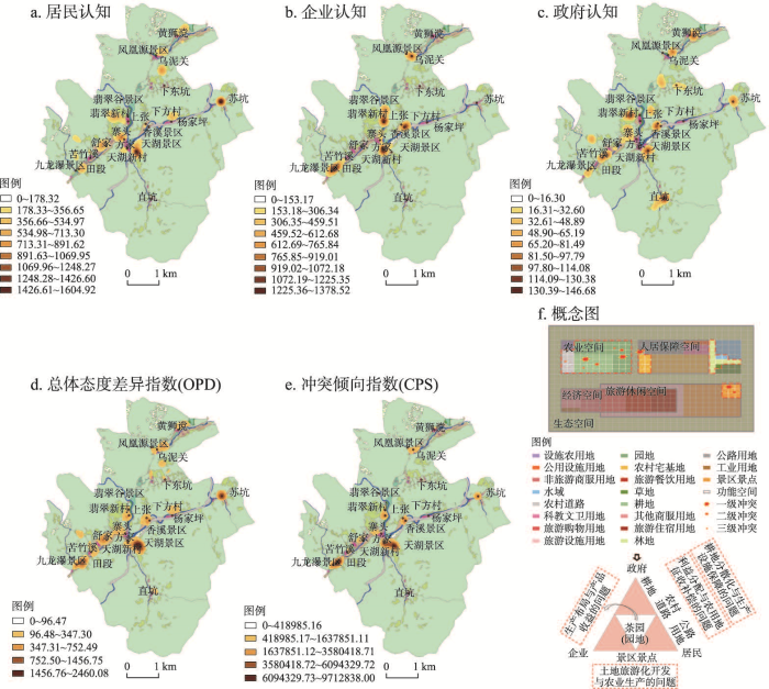
图4
利益主体农业功能空间认知冲突
Fig. 4
Cognitive conflict of agricultural function space of stakeholders
4.1.2 经济功能空间认知冲突分析
利益主体对经济功能认知主要集中于五大景区附近,呈现环景区周边的产业空间布局特征(图5a~5c)。结合图5d和OPD高值区类型可知,翡翠谷、九龙瀑、凤凰源为HB型;天湖和香溪为HM型。这些OPD高值区呈现景区发展程度对周边经济溢出效应存在明显分异的特征。根据CPS值进行判断(图5e),翡翠谷、天湖、九龙瀑、凤凰源属于一级冲突点,主要涉及非旅游商服、旅游住宿和旅游餐饮用地,以及部分景区景点用地。香溪为二级冲突点,涉及非旅游商服、旅游住宿和景区景点用地。在不同强度冲突点中,冲突最为突出的用地类型是非旅游商服用地,其次是旅游住宿餐饮和景区景点用地(图5f)。从冲突点涉及的利益主体来看,3个利益主体认知冲突集中体现在旅游住宿和景区景点用地。其中旅游住宿用地冲突反映了政府对住宿产业用地管控与居民、企业参与投资意愿的矛盾,并且一定程度上导致了居民和企业对住宿资源的竞争;景区景点用地冲突是由不均衡的旅游资源分配和不健全的收益分红机制造成的。企业与政府认知冲突主要体现在非旅游商服用地,政府空间管治下企业经营场所用地难是其主要原因。居民与企业认知冲突主要体现在旅游餐饮用地,企业有限的经营规模导致就业需求难以满足。整体上,经济功能冲突点主要集中在旅游商服和非旅游商服用地,是由不同利益主体对山区产业用地管控、山区建设用地紧缺、旅游收益分红认知差异造成的。
图5
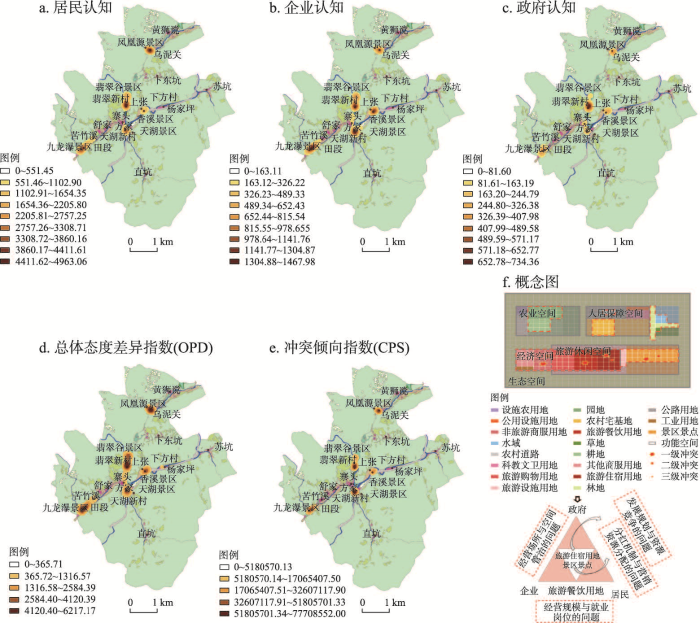
图5
利益主体经济功能空间认知冲突
Fig. 5
Cognitive conflict of economic function space of stakeholders
4.1.3 人居保障功能空间认知冲突分析
利益主体人居保障功能认知集中于沿交通干线的村民组,呈带状的交通区位取向特征(图6a~6c)。结合图6d和OPD高值区类型可知,天湖新村为HB型;上张、田段、舒家、寨头、乌泥关为HM型;黄狮谠和苏坑为LB型。这些OPD高值区集中分布于交通区位条件差异大的居民点。根据CPS值进行判断(图6e),天湖新村属于一级冲突点。该冲突点最为突出的用地类型是农村宅基地,其次为科教文卫、公用设施、公路用地以及生态和旅游用地(图6f)。从冲突点涉及的利益主体来看,3个利益主体认知冲突集中体现在农村宅基地,反映了政府对宅基地布局与整治未能满足居民对高品质生活和企业对宅基地商品化开发的需求。居民与政府认知冲突主要体现在科教文卫、公用设施和旅游设施用地,反映了居民不断提升的生活需求与政府服务设施配置不均衡不充分之间的矛盾。企业与政府认知冲突主要体现在公路用地,政府交通设施规划建设效率限制了企业的市场扩张。居民与企业认知冲突主要体现在水域,其原因在于旅游发展带来的水污染已经严重影响居民的日常生活。整体来看,人居保障功能认知冲突主要集中于农村宅基地、服务设施和生态环境,是由不同利益主体对基础设施配置、人居生活品质和乡村空间商品化程度认知差异造成的。
图6
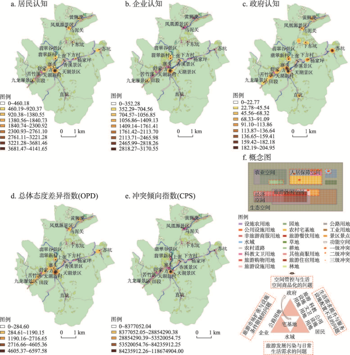
图6
利益主体人居保障功能空间认知冲突
Fig. 6
Cognitive conflict of habitat security function space of stakeholders
4.1.4 生态功能空间认知冲突分析
利益主体生态功能认知分布于山岔村全境,呈现生活、生产与生态空间认知叠合的特征(图7a~7c)。结合图7d和OPD高值区类型可知,田段、苦竹溪、寨头为HB型;天湖新村、直坑、黄狮谠附近为LB型。这些OPD高值区在空间上毗邻黄山风景区。根据CPS值进行判断(图7e),田段属于一级冲突点,表现在林地、水域和农业用地冲突。寨头和天湖新村属于二级冲突点,表现在水域和农业用地冲突。在不同强度冲突点中,冲突最为突出的用地类型是水域和农业用地,其次为林地(图7f)。从冲突点涉及的利益主体来看,居民、企业和政府认知冲突主要体现在水域、耕地和园地。水域冲突是由于政府未能有效管控污水排放,使得部分居民、企业用水遭受污染而导致的;其次为耕地、园地冲突,是由政府施行生态保护政策下野生动物泛滥损害居民和企业经济利益造成的。居民与政府认知冲突主要体现在林地,反映政府对生态红线管控与居民对生态资源利用的矛盾。总体来看,生态功能冲突点集中于水域、林地和部分农业用地,是由不同利益主体对生态环境规制、生态保护和生态效益认知差异造成的。
图7
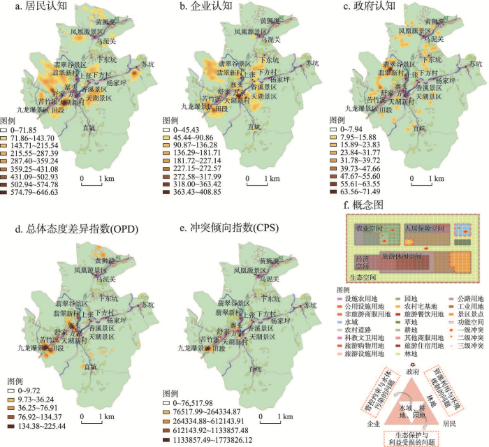
图7
利益主体生态功能空间认知冲突
Fig. 7
Cognitive conflict of ecological function space of stakeholders
4.1.5 旅游休闲功能空间认知冲突分析
利益主体旅游休闲功能认知集中于五大景区,呈以旅游景区为主导的区块式分布特征(图8a~8c)。结合图8d和OPD高值区类型可知,翡翠谷、凤凰源、九龙瀑为HB型;天湖和香溪为HM型。这些OPD高值区集中分布在旅游资源禀赋差异大的景区。根据CPS值进行判断(图8e),天湖、香溪景区属于一级冲突点,表现在景区景点、旅游住宿用地冲突。翡翠谷属于二级冲突点,认知冲突分布在景区景点、旅游住宿用地以及人居保障用地。九龙瀑景区、凤凰源景区属于三级冲突点,表现在景区景点与人居保障用地冲突。在不同强度冲突点中,冲突最为突出的用地类型是景区景点,其次是旅游住宿、人居保障用地(图8f)。从冲突点涉及的利益主体来看,居民、企业和政府认知冲突主要体现在景区景点、旅游住宿用地,反映了政府对旅游景区项目缺乏引导,导致项目同质化,进而影响周边居民、企业旅游收益。居民和政府认知冲突主要体现在农村宅基地,表现为政府旅游项目控制和居民居住空间混合利用的矛盾。企业和政府冲突主要体现在公路用地,政府规划旅游交通路线直接影响游客旅游企业选择,从而导致可达性较低的企业旅游收益受损。总体来看,旅游休闲功能冲突点集中在景区景点、旅游道路,是由旅游开发方式、旅游交通可达性、旅游收益认知差异造成的。
图8
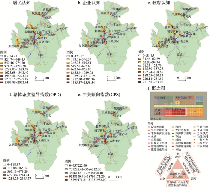
图8
利益主体旅游休闲功能空间认知冲突
Fig. 8
Cognitive conflict of tourism and leisure function space of stakeholders
4.2 利益主体多功能整体空间认知的冲突分析
利益主体多功能整体空间认知主要分布于五大景区,反映以景区为主导的资源集中、人口密集、产业集聚的特点(图9a)。多功能总体态度差异高值区集中分布于五大景区及G205沿线,空间分布受到资源禀赋、资源获取与开发条件的影响(图9b)。基于图9c分析可知:① 天湖景区多功能冲突倾向指数最高。天湖景区及其周边人口最为集中,现有农业生产、道路、科教文卫等设施保障不够完善,农业耕作空间有限,居民住宅密集,且日常生活空间随着民宿、商店等经济功能的不断开发而缩减,旅游发展还引发了生态污染,进一步加剧冲突。② 九龙瀑、翡翠谷、凤凰源、香溪景区多功能冲突倾向指数较高。现有茶园农业生产布局有待优化,旅游发展呈现以翡翠谷为核心的空间布局,存在不同景区分红不均、工资水平参差等现象,尚未形成以点带面的格局。此外,由于缺乏相应的管理和规划,旅游发展中恶意竞争现象时有出现。总体来看,在山岔村多功能空间认知冲突格局之中,旅游功能认知是主导,农业和经济功能认知是关键,而人居和生态功能认知是基本。这些不同功能认知交叠矛盾的特征,反映了当前各利益主体对自身发展的差异化利益诉求。
图9
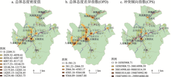
图9
利益主体多功能整体空间认知冲突
Fig. 9
Multifunctional overall spatial cognitive conflict of stakeholders
5 利益主体多功能空间认知冲突的协调机制
5.1 利益主体多功能诉求协调发展状态分析
5.1.1 指标体系构建
表2 多功能空间认知冲突访谈文本数据示例
Tab. 2
| 访谈文本片段 | 编码 |
|---|---|
| 茶园比较小,太分散了,产量一般,而且难以管理;农业生产受野猪的影响,农作物都被它们破坏了。 | 农产品产量 |
| 一年大概是8000元左右收入,收入低;茶叶价格好的时候大概300多元,价格差的时候大概是100元左右。 | 农产品价格 |
| 茶叶都是自产自销的,去汤口镇的路边卖茶叶,也没有收购中心可以销售。 | 农产品销量 |
| 这边都是高山茶,土壤条件不错,所以茶的品质很好。 | 农产品品质 |
表3 主轴译码结果
Tab. 3
| 主范畴 | 范畴化 | 概念化 | 贴标签 |
|---|---|---|---|
| 农业功能 | 农产品产销 | 农产品产量 | 产量、破坏、管理、野猪、茶叶、茶园、茶树 |
| 农产品价格 | 价格、人工费、收入 | ||
| 农产品销量 | 销售、收购、销量、销路、市场、自产自销 | ||
| 农产品品质 | 品质、毛竹质量、土质 | ||
| 农业生产面积 | 耕地面积 | 茶园面积、耕地面积、退耕还林 | |
| 山场面积 | 封山育林、毛竹、山场、木材 | ||
| 农业政策 | 农业补贴 | 补贴、补助、租金 | |
| 土地征收政策 | 征收、承包、政府 | ||
| 经济功能 | 就业机会 | 旅游就业 | 就业岗位、上班、打零工、工作机会 |
| 收入来源 | 劳动收入 | 工资、赚钱、农作物、摆摊、外出打工 | |
| 转让收入 | 土地征用、房屋使用权 | ||
| 分红收入 | 分红、福利、景区红利 | ||
| 收入差距 | 旅游引发的收入差距 | 公平、发展不平衡、竞争、贫富差距、淡旺季 | |
| 经济政策 | 旅游相关经济政策 | 经济政策、贷款、免税、普惠制、保障 | |
| 人居保障功能 | 生活居住面积 | 村庄面积 | 村庄大、面积大、分散 |
| 住房面积 | 居住面积、索道、危房、房屋规划、地皮、拆迁 | ||
| 活动面积 | 休闲娱乐空间、拥挤、绿化面积 | ||
| 交通状况 | 地理区位 | 距离、汤口 | |
| 便捷性 | 方便、交通、公交、班车、道路、堵车 | ||
| 基础设施 | 公共服务配套设施 | 医务室、教育、政府、路灯、停车场、休闲娱乐设施 | |
| 生活消费水平 | 旅游引发的物价变动 | 物价水平、不景气、资金 | |
| 生态功能 | 生态基底 | 森林覆盖 | 砍伐、森林、覆盖率90%、木材 |
| 环境质量 | 空气清新、水质好、水污染、可见度 | ||
| 旅游开发的环境影响 | 旅游开发的环境影响 | 绿化、丢垃圾、破坏、污染、工厂 | |
| 生态保护意识与行为 | 生态保护意识 | 环保意识、护林、乱砍滥伐、指标 | |
| 生态保护效果 | 政府、野生动物、山清水秀 | ||
| 旅游休闲功能 | 旅游景点 | 景点数量 | 景点多 |
| 景点面积 | 景区占地 | ||
| 景点吸引力 | 一成不变、同质性、品牌、吸引力 | ||
| 旅游效益 | 旅游收入 | 农家乐、经营、游客消费、分红 | |
| 旅游人数 | 游客接待、游客分散 |
在识别多功能空间认知冲突影响因素的基础上,基于科学性、实用性和前瞻性等基本原则,从五大功能角度出发,构建符合山岔村实际情况的多功能诉求协调发展指标体系(图10),为建立利益主体多功能空间认知冲突协调机制提供线索和思路。
图10
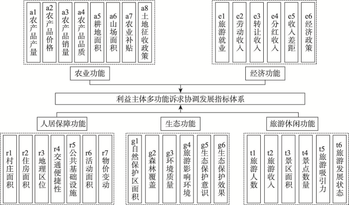
图10
山岔村利益主体多功能诉求协调发展指标体系
Fig. 10
Coordinated development indicator system for multifunctional appeal of stakeholders in Shancha Village
5.1.2 农业功能诉求协调发展状态
表4 利益主体多功能诉求协调发展状态
Tab. 4
| 指标 | 利益主体 | |||||||||||
|---|---|---|---|---|---|---|---|---|---|---|---|---|
| 居民 | 企业 | 政府 | ||||||||||
| P | E | 状态 | P | E | 状态 | P | E | 状态 | ||||
| 农业功能 | 农产品产量a1 | 4.62 | 0.20 | ▼ | 2.90 | 0.06 | ◆ | 2.80 | -0.20 | ● | ||
| 农产品价格a2 | 4.60 | 0.20 | ▼ | 2.66 | 0.05 | ◆ | 4.26 | 0.07 | ◆ | |||
| 农产品销量a3 | 4.88 | 0.86 | ▼ | 2.32 | -0.01 | ● | 3.06 | -0.04 | ● | |||
| 农产品品质a4 | 3.83 | -0.70 | ● | 3.15 | -0.30 | ● | 4.89 | -0.04 | ★ | |||
| 耕地面积a5 | 3.64 | 0.38 | ◆ | 2.87 | 0.14 | ◆ | 3.62 | -0.20 | ● | |||
| 山场面积a6 | 5.28 | -0.69 | ★ | 2.49 | 0.19 | ◆ | 4.85 | 1.11 | ★ | |||
| 农业补贴a7 | 5.79 | 0.20 | ▼ | 4.03 | 0.19 | ◆ | 4.55 | 0.58 | ▼ | |||
| 土地征收政策a8 | 5.47 | -0.01 | ★ | 4.37 | 0.19 | ▼ | 2.65 | 0.03 | ◆ | |||
| 经济功能 | 旅游就业e1 | 6.18 | 0.26 | ▼ | 5.46 | -0.40 | ★ | 2.22 | -0.03 | ● | ||
| 劳动收入e2 | 5.43 | 0.04 | ▼ | 5.53 | -0.03 | ★ | 2.00 | 0.00 | ● | |||
| 转让收入e3 | 5.32 | 0.30 | ▼ | 4.52 | 0.29 | ▼ | 2.47 | -0.03 | ● | |||
| 分红收入e4 | 5.74 | 1.02 | ▼ | 4.58 | 0.62 | ▼ | 3.04 | -0.20 | ● | |||
| 收入差距e5 | 6.62 | 0.14 | ▼ | 3.22 | 0.22 | ◆ | 3.61 | 0.09 | ◆ | |||
| 经济政策e6 | 6.49 | 0.61 | ▼ | 3.60 | 0.39 | ◆ | 2.71 | -0.10 | ● | |||
| 人居保障功能 | 村庄面积r1 | 3.75 | -0.06 | ● | 5.26 | -0.05 | ★ | 2.98 | -0.20 | ● | ||
| 住房面积r2 | 3.10 | -0.07 | ● | 4.12 | -0.03 | ● | 4.26 | -0.02 | ● | |||
| 地理区位r3 | 3.37 | -0.03 | ● | 4.79 | -0.14 | ★ | 4.93 | -0.06 | ★ | |||
| 交通便利性r4 | 3.56 | 0.14 | ◆ | 4.21 | 0.04 | ◆ | 3.19 | -0.21 | ● | |||
| 公共基础设施r5 | 3.67 | 0.26 | ◆ | 3.43 | 0.18 | ◆ | 2.84 | -0.04 | ● | |||
| 活动面积r6 | 3.92 | 0.19 | ◆ | 2.74 | 0.17 | ◆ | 3.38 | 0.09 | ◆ | |||
| 物价变动r7 | 3.39 | 0.14 | ◆ | 3.01 | 0.12 | ◆ | 3.70 | -0.07 | ● | |||
| 生态功能 | 自然保护区面积g1 | 5.15 | -0.85 | ★ | 5.48 | -0.79 | ★ | 6.43 | -0.01 | ★ | ||
| 森林覆盖g2 | 3.54 | -0.43 | ● | 4.23 | -0.80 | ● | 3.55 | -0.27 | ● | |||
| 环境质量g3 | 4.31 | 0.20 | ◆ | 3.26 | -0.28 | ● | 4.66 | -0.25 | ★ | |||
| 旅游影响环境g4 | 5.77 | -0.09 | ★ | 5.76 | 0.48 | ▼ | 2.73 | -0.21 | ● | |||
| 生态保护意识g5 | 5.32 | -0.75 | ★ | 5.59 | 0.32 | ▼ | 5.20 | -0.49 | ★ | |||
| 生态保护效果g6 | 5.89 | -0.77 | ★ | 5.86 | -0.74 | ★ | 5.66 | -0.24 | ★ | |||
| 旅游休闲功能 | 游客人数t1 | 3.83 | -0.27 | ● | 4.85 | 0.30 | ▼ | 5.03 | 0.59 | ▼ | ||
| 旅游收入t2 | 6.22 | 0.36 | ▼ | 6.03 | -0.01 | ★ | 3.89 | -0.01 | ● | |||
| 风景区面积t3 | 5.35 | -0.62 | ★ | 4.66 | -0.36 | ★ | 6.55 | -0.02 | ★ | |||
| 景点数量t4 | 4.51 | -0.38 | ★ | 4.19 | -0.61 | ★ | 6.64 | -0.17 | ★ | |||
| 旅游吸引力t5 | 4.16 | -0.01 | ● | 4.87 | 0.15 | ▼ | 4.06 | -0.26 | ● | |||
| 旅游发展状态t6 | 5.63 | -0.44 | ★ | 3.85 | -0.20 | ● | 2.79 | -0.19 | ● | |||
注:P中心度,E原因度,★优质协调,●中度协调,◆轻度协调,▼濒临失调。
图11
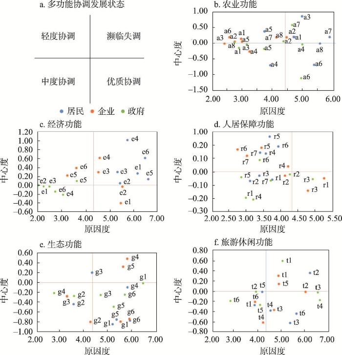
图11
多功能中心度和原因度四象限分布图
Fig. 11
Four-quadrant distribution of multifunctional centrality and causality
5.1.3 经济功能诉求协调发展状态
居民和企业对经济功能诉求较为突出,居民在经济功能各方面的诉求均位于第一象限。从企业角度,“转让收入”“分红收入”诉求处于濒临失调的发展状态,是影响协调发展的主导因素(图11c)。旅游发展未能给非旅游从业者带来经济效益,且村集体分红较低,导致贫富差距大,利益主体间矛盾凸显。而部分从事旅游经营的当地居民对房屋改造,减少了房屋资源,进而增加了旅游企业的扩张压力和经营竞争。企业和政府“收入差距”诉求处于轻度协调的发展状态,均认为旅游发展一定程度上为旅游从业者增加了家庭收入,但导致收入两极分化。同时,在“经济政策”上企业认为当前旅游发展缺乏政府正确引导,引发旅游经营者间恶性竞争。企业的“旅游就业”“劳动收入”诉求处于优质协调的发展状态,获得的丰厚收入提高了企业效益。
5.1.4 人居功能诉求协调发展状态
利益主体对人居功能满意程度较高,呈现出较好的协调状态(图11d)。居民和企业“交通便利性”“公共基础设施”“活动面积”等诉求位于第二象限,处于轻度协调的发展状态,认为道路等公共设施有待完善。利益主体“住房面积”诉求位于第三象限,良好的居住功能一定程度上促进了该功能诉求的协调发展。除此之外,基于生活的便捷性和游客的涌入情况,企业和政府“地理区位”诉求都位于第四象限,处于优质协调的发展状态。
5.1.5 生态功能诉求协调发展状态
企业对生态功能诉求较为突出,“旅游影响环境”和“生态保护意识”诉求位于第一象限,处于濒临失调状态,是主导因素(图11e)。企业主认为旅游开发虽然吸引了游客,但部分游客生态保护意识不高,存在乱丢垃圾的现象。居民“环境质量”诉求处于轻度协调状态,认为民宿污水排放对当地水资源造成破坏。利益主体“森林覆盖”诉求位于第三象限,处于中度协调状态,共同认为森林覆盖率高,生态环境良好。利益主体“自然保护区面积”和“生态保护效果”诉求均处于第四象限,认为山岔村自然保护区广阔,生态环境保护成效显著。
5.1.6 旅游休闲功能诉求协调发展状态
各利益主体对游客人数和旅游收入诉求突出(图11f),居民认为家庭主要收入来源是外出打工,旅游发展并未提高个人收入。企业认为疫情导致了游客数量的下降,并且当前景区发展缺乏特色,应加强对景区的建设与优化。政府旅游休闲功能诉求大多位于第三象限,认为除受疫情的特殊影响,当前旅游整体发展状态较好。各利益主体“景区面积”和“景点数量”诉求处于优质协调发展状态。
5.2 利益主体多功能空间认知冲突的协调机制
缓和利益主体多功能空间认知的冲突,实现山岔村利益主体多功能诉求的优质协调发展,必须对各利益主体的身份定位和相互关系进行调整,进而建立一个以满足利益主体诉求为核心,充分发挥各主体作用的利益协调机制(图12)。当地政府作为决策者和管理者,对乡村旅游地多功能协调发展起调控作用。政府通过行政管理等形式约束企业的经营行为,企业通过与政府间有效沟通,消除经营隐患,提高经济效益。在政府引导下,居民积极参与旅游经济活动,增加生计收入,提高生活质量和水平。居民和企业为实现利益诉求,通过民主评议与监督机制参与政府决策。居民作为资源所有者,可以利用手中资源参与旅游投资并监督旅游企业经营,享受利益分红,减少因贫富差距而产生的利益冲突。企业作为开发者,应合理开展经营活动,严格遵守政府出台的各项规定,落实企业社会责任,帮助弱势居民满足利益诉求,形成多方发展、福利共享的发展局面。
图12
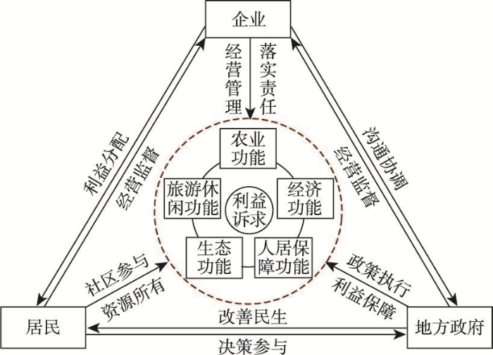
图12
利益主体多功能空间认知冲突协调机制
Fig. 12
Multifunctional spatial cognitive conflict coordination mechanism of stakeholders
5.3 利益主体多功能空间认知冲突的协调路径
基于利益主体多功能诉求协调发展状态分析,针对突出的多功能诉求,提出协调路径。① 农业功能方面,实行精准化补贴与销售路径。对农业生产行为提出限制条件,明确补贴对象是拥有耕地承包权的种地农民。鼓励“政府+网红”带货模式,提升农产品知名度,弥补农民自产自销的不足。② 经济功能方面,实行产业平台集散路径。为非从事旅游业的居民搭建培训平台,实现旅游从业人员遴选工作与岗位培训工作同步推进。加快产业转型升级,建立健全现代农业产业体系,严选具有地方特色的农副产品,助力农民增收致富。③ 人居保障功能方面,实行功能集约完善路径。重新系统规划山岔村交通体系,整修问题路段,完善道路交通标识,增加公交线路停靠点和班次。加强医疗、教育、休闲娱乐等社会设施建设,制定法规强化公共空间监管。④ 生态功能方面,实行生态意识强化与利益补偿路径。增设文明标识牌、环保宣传栏等,增强游客保护环境的意识。建立生态补偿机制,强化企业生态环保责任意识,通过经济补偿、政策补偿等方式补偿居民受损的利益。⑤ 旅游休闲功能方面,实行产业股权激励路径。充分发挥村级组织基层桥头堡作用,建立以多元主体为核心的股权制度,鼓励居民以生产要素入股投资当地旅游业发展,实现居民向“股东”身份转变,保障居民旅游分红收益。
6 结论与讨论
6.1 结论
从核心利益主体对多功能空间认知出发,分析其产生的空间认知冲突,针对冲突点,探寻冲突动因,并从利益协调角度提出冲突协调机制与协调路径。重要结论为:
(1)结合多功能理论和利益相关者理论,聚焦地理学空间认知,本文构建了乡村旅游地利益主体多功能空间认知“冲突—协调”理论研究框架,并提出利益主体多功能空间认知“冲突—协调”内在关联机制表现在3个层面:驱动层面的多功能供需差异、冲突层面的多功能空间认知冲突、协调层面的多功能诉求协调路径。
(2)在利益主体多功能空间认知冲突特征方面,多功能空间认知集聚点是利益主体供需矛盾、认知冲突最为激烈的区域。利益主体农业功能认知集中于13个居民点附近,呈现农村居民点与耕地的空间邻接特征,并反映居民点受到山区耕作半径制约的特点。OPD高值区集中分布在农业生产条件认知差异大的区域和人口密度高的居民点。CPS反映的主要冲突点集中在耕地和园地,由利益主体对山区农业的生产布局、设施保障和产出效益认知差异造成。经济功能认知主要集中于景区附近,呈现环景区周边的产业空间布局特征。OPD高值区呈现景区发展程度对周边经济溢出效应存在明显分异的特征。冲突点主要集中在旅游商服和非旅游商服用地,由不同利益主体对山区产业用地管控、建设用地紧缺、旅游收益分红认知差异造成。人居保障功能认知集中于沿交通干线的村民点,呈带状的交通区位取向特征。OPD高值区集中分布于交通区位条件差异大的居民点。冲突点主要集中于农村宅基地、服务设施和水域,由不同利益主体对基础设施配置、人居生活品质和乡村空间商品化程度认知差异造成。生态功能认知分布遍布村域,呈现生活、生产与生态空间认知叠合的特征。OPD高值区在空间上毗邻黄山风景区。冲突点集中于水域、林地和部分农业用地,由不同利益主体对环境规制、生态保护和生态效益认知差异造成。旅游休闲功能认知集中于景区,呈以旅游景区为主导的区块式分布特征。OPD高值区集中分布在旅游资源禀赋差异大的景区。冲突点集中在景区景点、旅游道路,由旅游开发方式、旅游交通可达性、旅游收益认知差异造成。
(3)基于访谈文本,本文提炼并构建出利益主体多功能诉求协调发展评价指标体系。评价结果显示:农业功能方面居民诉求突出,“农产品产量”“农产品销量”“农业补贴”等诉求是影响其协调发展的主导因素;经济功能方面居民和企业诉求突出,居民关于经济功能所有的利益诉求均为主导因素,企业对“转让收入”和“分红收入”的诉求是主导因素;人居功能方面整体满意程度较高,协调状态较好;生态功能方面企业诉求突出,“旅游影响环境”和“生态保护意识”诉求是主导因素;旅游休闲功能方面整体呈现较好的协调发展状态,但存在个别影响协调发展的主导因素,分别是政府、企业对“旅游人数”,企业对“旅游吸引力”和居民对“旅游收入”的诉求。
(4)在协调发展状态方面,构建了利益主体多功能空间认知冲突协调机制。以满足利益主体诉求为出发点,明晰政府、企业和居民在多功能认知形成中的权力与责任,建立企业居民间分配与监督、政府居民间改善与参与、企业政府间沟通与监督的相互制衡机制。同时,针对5个功能分别提出与之相对应的农业精准化补贴与销售、经济产业平台集散、人居社会功能集约完善、生态意识强化与利益补偿、旅游休闲产业股权激励等协调路径。
6.2 讨论
新时期乡村旅游地多功能研究是乡村可持续发展的研究热点。立足中国国土空间区域差异大、乡村旅游类型分异明显的发展特色,未来需要进一步加强典型案例地比较研究,总结乡村旅游地多功能发展一般性规律,这也是新时期推动乡村旅游地可持续发展和乡村振兴的重要着力点。面向乡村振兴国家战略,探讨“自下而上”和“自上而下”相结合的研究范式,强化理论研究、应用导向型研究和偏重技术导向型研究间的相互结合,推进乡村可持续发展的科学决策。研究乡村旅游地各功能认知之间的组合状态,探索不同功能之间拮抗与协同方式 [11]。决定利益主体多功能空间认知差异,是其对于利益和价值的判断。从价值判断形成的过程出发,深入分析具有不同身份、职位、权力的利益主体对多功能空间价值判断的差异[54],构建多元主体共享的价值机制,减少空间认知冲突[55]。在多功能认知的评价体系方面,将利益主体对政治、情感、文化、意义等更加复杂的非利益诉求纳入多功能的评价体系中。
参考文献
Spatial differentiation characteristics and trade-off/synergy relationships of rural multi-functions based on multi-source data
DOI:10.11821/dlyj020201140
[本文引用: 1]

Based on land use, point of interest, socio-economic statistics and other data, this study constructs an evaluation system of rural function from five dimensions of economic development, agricultural product production, social security, ecological services and tourism and leisure, and reveals the spatial characteristics of the five functions above and their comprehensive functions of the ecological conservation area from the township scale. By means of Spearman rank correlation analysis, production possibility frontier (PPF) and trade-off intensity index and so on, the trade-off coordination relationship and the degree of trade-off between rural functions are quantitatively discussed. The results show that: (1) the spatial patterns of economic development, social security and leisure tourism functions are similar; on the contrary, the functions of economic development, social security and agricultural products production in towns with strong ecological service function are often weak. (2) There is a significant synergy relationship between economic development and agricultural production / social security function, and a significant trade-off relationship between economic development / agricultural production / social security and ecological service function. And the trade-off intensity is economic development - ecological services > social security - ecological services > agricultural production - ecological services. When it comes to the PPF curve, we can conclude that the trade-off between economic development / agricultural product production and ecological service function is similar. That is to say, the trade-off between which will be weakened while sustainably developing the ecological services. The trade-off between social security and ecological services will intensify with the continuous investment of ecological services. The synergetic effect of economic development on agricultural production (social security) function will slow down with the development of economic function. (3) According to the idea of "the less the trade-off intensity is, the symbiotic development among functions" and "the greater the trade-off intensity, the most one function can be developed". In order to maximize the comprehensive income of rural functional combination, the ecological conservation area will be divided into four types of development areas: I (four types of functional symbiosis), II (three kinds of functional symbiosis), III (two kinds of functional symbiosis) and IV (single function development). The research results will be helpful for regional rural revitalization and development planning, and provide technical support for scientific design of rural function collaborative development path.
基于多源数据的乡村功能空间特征及其权衡协同关系度量
DOI:10.11821/dlyj020201140
[本文引用: 1]
本研究基于土地利用、兴趣点、社会经济统计等数据,从乡镇尺度揭示了北京生态涵养区经济发展、农产品生产、社会保障、生态服务、旅游休闲以及综合功能的空间特征,并运用Spearman秩相关分析、生产可能性边界(PPF)、权衡强度指数等定量探讨了多功能间的权衡-协同关系及其权衡程度。结果表明:① 经济发展、社会保障和休闲旅游功能的空间格局相似;生态服务功能与经济发展、社会保障和农产品生产功能的空间格局基本相逆。② 经济发展与农产品生产/社会保障功能为显著协同关系;经济发展/农产品生产/社会保障与生态服务功能为显著权衡关系。③ 按照“‘权衡强度越小,功能间共生发展’‘权衡强度越大,最多发展一种功能’”的思路,以追求乡村功能组合的综合效益最大化为目标,将生态涵养区划分为I(4种功能共生)、II(3种功能共生)、III(2种功能共生)和IV(单一功能发展)4种类型区。研究结果将为区域乡村振兴规划编制提供参考,为乡村功能协同发展路径设计提供技术支撑。
Research on environmental conflict analyses and its signification in geography
DOI:10.11821/xb1998s1023
[本文引用: 1]
Environmental conflict consists of the conflicts, between human activities and geographical environment in different areas, with different extent and form. It takes place more frequently with the development of economy, improper and excess exploitation of natural resources, and the out-of-order competition among departments and regions. This thesis introduces the devel-opment of the research overseas. Due to its obvious regionalism and inter-conditioning and inter-dependence with elements of physical and human geography, Environmental conflict has pro-found geographical signification handling environmental conflict by the same principle of justice in dealing with inter-regional, inter-department, and inter-generation conflicts, reliably regional sustainable development is essential. Then, the application of environmental conflict analysis in geographical research is tentatively discussed.
环境冲突分析研究及其地理学内涵
Multifunctional 'quality' and rural community resilience
DOI:10.1111/tran.2010.35.issue-3 URL [本文引用: 1]
Rural geography: Multifunctional rural geographies-reactionary or radical?
DOI:10.1191/0309132505ph584pr URL [本文引用: 1]
Impulses towards a multifunctional transition in rural Australia: Gaps in the research agenda
DOI:10.1016/j.jrurstud.2005.08.006 URL [本文引用: 1]
Function-analysis and valuation as a tool to assess land use conflicts in planning for sustainable, multi-functional landscapes
DOI:10.1016/j.landurbplan.2005.02.016 URL [本文引用: 1]
A study on the villagers' semantic understanding of functional challenges in rural settlements (Case study: Centeral district of Ravansar County)
Multifunctionality assessment of the land use system in rural residential areas: Confronting land use supply with rural sustainability demand
DOI:S0301-4797(18)31054-5
PMID:30336345
[本文引用: 1]
By applying an integrated framework, we developed a new way to quantify the multifunctionality of rural residential land: analyzing the reciprocal relationships between the structure and function of land use, as well as identifying the demand of rural sustainability for residential land functions. In the assessment of the rural residential land functions from the supply and demand perspectives by establishing an indicators system, the results show that there are five substantial functions of rural residential land, i.e., residential, public service, industrial, commercial and ecological function, and a potential function. Unbalanced development patterns between function supply and demand are clearly observed at multilevel: at the regional level, demand exceeding supply refers to the public service, commercial, and ecological function, especially for ecological function; at the town level, the spatial pattern of the difference is closely linked with topographic features; the inferior and complex topographic condition always is associated with inadequate function supply. Strategies based on the arrangements of rural residential land use structure, including function conversion and function enhancement, have been adopted to balance the supply and demand of land functions. Together, alternative strategies (e.g., industrial allocation, population introduction, and location choices) also need to be recognized by policymakers to achieve rural sustainable development.Copyright © 2018 Elsevier Ltd. All rights reserved.
Diversified agriculture and rural development in China based on multifunction theory: Beyond modernization paradigm
DOI:10.11821/dlxb201502007
[本文引用: 2]
There is a big gap between general rural modernization paradigm and huge empirical rural geography studies. This gap results in impotent development strategies on regionally differentiated countryside. Based on multifunctional agriculture theory and multifunctional rural theory which emerged in Western World as a new paradigm, this paper discusses the multiple objectives, differentiated pathways and policies of agriculture and rural development in China. Firstly, this paper reflects the problems and challenges caused by modernization paradigm in rural China on economic, social, and environmental aspects, as well as that of western developed countries. It can be concluded that conventional agricultural and rural modernization is developed largely at the expense of rural environment, social fabric and economic viabilities. Obviously, "modernization development paradigm" alone is not enough for healthy agricultural and rural development in such booming economy as China. A better paradigm should be developed which takes economic development, social justice and environmental sustainability into account at the same time. After a brief review of multifunctional agriculture theory and multifunctional rural theory overseas, the multiple objectives of agriculture and rural development in China are put forward. These multiple objectives, however, should not and could not be a burden on rural space indiscriminatingly due to the enormous differentiation of natural and socio-economic conditions. Thus, the final but main part of this paper envisions the differentiated pathways and policy portfolios of agricultural and rural development in China from the perspective of territorial division.
基于多功能理论的中国乡村发展多元化探讨: 超越“现代化”发展范式
DOI:10.11821/dlxb201502007
[本文引用: 2]
传统的乡村现代化发展范式和地理学关于乡村的区域差异研究之间存在缝隙,不足以为快速演化分异的乡村地域发展提供直接理论支撑。本文引入西方近20年来逐渐兴起的多功能农业与多功能乡村理论,从新的视角观察思考中国乡村多元化发展的目标、路径及对策。首先从经济、社会和环境三个方面反思中国乡村现代化的基本历程与得失,以及西方国家乡村现代化产生的问题,指出传统的农业农村现代化发展在很大程度是以牺牲乡村环境和乡村社会机理脆弱化为代价的,也造成了乡村经济对外部支持的过度依赖,仅仅强调“现代化”发展范式显然是不够的;然后简要介绍了国外多功能农业与多功能乡村理论;在此基础上,从功能角度提出中国农业农村发展的多元目标,推演探讨农业农村发展的区域差异化路径及对策。
Progress and prospect in the study of rural region multifunctions
乡村地域多功能的研究进展与展望
International research progress and perspectives on multifunctional landscape
DOI:10.1167/j.issn.1001-8166.2015.04.0465
[本文引用: 1]
As a bridge between natural landscape and human society, landscape function is always an important content of landscape ecology. Multifunctional landscape becomes closely related with the decision of land use by means of endowing landscape function with human value judgments. Till now, it has been an important development direction of landscape function research, an important field of multi-disciplinary integrated landscape study, as well as a new discipline growth of landscape ecology. Based on comprehensively analyzing the conceptual connotation of multifunctional landscape, the similarities and differences among the four concepts, i.e., multifunctional landscape, landscape multi-functionality, multifunctional agriculture, and ecosystem services are also fully contrasted and clarified. Focused on such three key issues as landscape multi-functionality assessment, spatial identification of multifunctional landscape, and multifunctional landscape planning and management, the updated research progress and main shortcomings on multifunctional landscape are deeply discussed. Finally, five topics are proposed as future research directions on multifunctional landscape, i.e., mechanism analysis of trade-offs in multifunctional landscape, regional categorization of multifunctional landscape, scaling and zoning effects assessment of multifunctional landscape, dynamic prediction of multifunctional landscape, and scenario simulation of multifunctional landscape.
国内外多功能景观研究进展与展望
DOI:10.1167/j.issn.1001-8166.2015.04.0465
[本文引用: 1]
作为沟通自然景观与人类社会的重要桥梁,景观功能一直以来都是景观生态学的重要研究内容;多功能景观通过对自然景观功能赋予人类价值评判,与土地利用决策紧密相关,已成为当前景观功能研究的重要发展方向、多学科景观综合研究的重点领域和景观生态学新的学科生长点。在系统梳理多功能景观概念内涵的基础上,对比分析了其与景观多功能性、生态系统服务及多功能农业的概念异同;并从景观多功能性评价、多功能景观空间识别、多功能景观规划与管理等3个方面,重点探讨了近年来国内外多功能景观研究的进展及其主要不足;最后,展望了当前国内外多功能景观研究的重点发展方向,即多功能景观权衡机理解析、多功能景观区域类型识别、多功能景观尺度与划区效应评估、多功能景观动态预测及情景模拟。
Knowledge structure of rural function in China: An analysis based on CiteSpace map.
DOI:10.1080/00130095.1961.11729540 URL [本文引用: 1]
基于CiteSpace中国乡村功能研究的知识图谱分析
Spatial differentiation and influencing factors of rural territorial multifunctions in developed regions: A case study of Jiangsu province
DOI:10.11821/dlxb201406007
[本文引用: 2]
With the rapid economic development, social progress, and land use change in rural regions, rural territorial function and development orientation show more significant spatial differentiation and diversification. Using the well-developed Jiangsu province as a case, this paper quantitatively identified and calculated four rural territorial functions at county level, i.e., ecological conservation, agricultural production, industrial development and social security. Subsequently, the influencing factors of spatial differentiation on rural territorial functions for 63 regional units were analyzed; the dominated functions of each spatial unit were also identified. According to the case study, the multifunctional feature of rural territorial function was evident, however the function of industrial development was of significant dominance accompanying with the increase of dominant degree from northern to southern in Jiangsu province. The spatial agglomeration degrees of four rural territorial functions were low with variant agglomerative areas, that was, ecological conservation function was mainly distributed at coastal, surrounding lake and mountain areas, agricultural production function was mainly found in the northern and central parts, the industrial development function was predominately in the southern part, social security function which had the lowest spatial agglomeration was obviously distributed in municipal districts and their surrounding counties rather than other counties. The functional combinations of the 63 regional units were diversified and nine functional types were identified. Results of influencing factors analysis indicated that the natural geographical characteristics, spatial location, and economic development were the main influencing factors of differentiation on rural territorial functions, but their effects were of different intensities and directions for the spatial differentiation of four rural territorial functions. Specifically, the industry development function was mainly affected by road density, location advantage, FDI, GDP and floating population from other places; most factors were negatively related with the agricultural production function except the areas of important ecological function zones and cultivated lands; the relationships between the ecological conservation function and influencing factors were complicated, in which some more developed counties also had higher ecological conservation function; the social security function had very weak relationships with influencing factors owing to its complexity. This paper provided a scientific reference for identifying the rural development orientation, promoting the differential development, enhancing the characteristics and competitiveness of different counties; meanwhile, it was a meaningful supplement for the research of Major Function Oriented Zoning and related studies about territorial function.
经济发达地区乡村地域多功能空间分异及影响因素: 以江苏省为例
DOI:10.11821/dlxb201406007
[本文引用: 2]
随着经济社会发展和土地利用格局变化,乡村地域功能和发展定位的多元化和空间差异特征日益明显。以经济发达的江苏省为例,采用定量化价值评价方法,研究县域尺度乡村地域生态保育、农业生产、工业发展和社会保障功能的空间差异,识别各县市区主导功能类型,揭示不同类型乡村地域功能的影响因素。结果表明:乡村地域多功能特征明显,工业发展功能占据主导;4 类乡村地域功能空间集聚程度均较低,生态保育功能高值区集中于沿湖、沿海或苏南山丘地区,农业生产功能集中于苏北和苏中,工业发展功能以苏南最强,社会保障功能则集中于市辖区及其临近市县;乡村地域功能组合类型多样,共可分为9 种;4 类乡村地域功能的影响因素存在较大差异,自然地理、空间区位、经济社会发展等因素的影响在强度和影响方向上明显不同。研究可为针对性地定位乡村功能和发展导向、增强县域乡村功能特色和竞争力提供参考依据。
Land consolidation and rural vitalization: A perspective of land use multifunctionality
DOI:10.18306/dlkxjz.2021.03.012
[本文引用: 1]
The long-term supply-demand imbalance of rural land use functions (RLUFs) is one of the main reasons for rural issues in China. Based on the multifunctionality theory, this study explained the mutual relationship between rural land consolidation (RLC) and rural vitalization with a focus on supply-demand and element-structure-function relationships, and then discussed how to realize the supply-demand balance of RLUFs through RLC so as to promote sustainable rural development. The results show that: 1) Comprehensive rural land consolidation is a multifunctional land use method and an important means to solve rural issues for promoting rural vitalization. In essence, it is the transition from productivism that focuses on economic benefits to non-productivism that takes social, economic, and environmental benefits as a whole. 2) RLUFs include production, living, ecological, and cultural functions, corresponding to the economic, social, enviromental, and cultural demands of rural vitalization. The production functions are divided into agricultural, commercial, and industrial functions, and living functions include residential, employment, and public service functions. 3) Along the path of integrating land use elements, restructuring land use structures, and optimizing land use functions, RLC promotes the supply-demand balance of RLUFs from the supply side according to local conditions. 4) In future research, the mechanisms and modes of RLC impact on rural vitalization at different spatial scales, as well as quantitative analysis of the functional supply of land use and the functional demand of rural vitalization under the influence of RLC should be given more attention, thus laying a scientific foundation for the formulation and implementation of land use and rural vitalization planning.
土地整治与乡村振兴: 土地利用多功能性视角
DOI:10.18306/dlkxjz.2021.03.012
[本文引用: 1]
长期以来乡村土地利用功能的供需不平衡是造成乡村问题的主要原因之一。论文基于土地利用多功能性视角,以“供给—需求”“要素—结构—功能”为主线,阐释了农村土地整治与乡村振兴的互馈关系,探讨了如何通过农村土地整治实现乡村土地利用功能的供需平衡,进而促进乡村振兴。研究结果如下:① 综合土地整治是一种多功能的土地利用方式,是当前解决乡村问题、促进乡村振兴的重要手段,其本质是从以经济效益为主的生产主义向兼顾社会、经济、环境等的非生产主义的转变。② 乡村土地利用具有生产、生活、生态、文化等4种主要功能,满足乡村振兴在经济、社会、环境、文化等方面的需求,其中生产功能分为农业、商业、工业生产功能,生活功能分为居住、就业和公共服务功能。③ 农村土地整治沿整合土地利用要素、重组土地利用结构、优化土地利用功能的路径,从供给侧因地制宜地平衡乡村发展对土地利用多功能的需求。④ 今后,农村土地整治与乡村振兴的研究应该考虑不同空间尺度下土地整治对于乡村振兴的作用机制与模式,定量分析土地整治影响下土地利用的多功能供给以及不同类型乡村发展对土地利用功能的需求,从而为土地利用和乡村振兴规划的制定和实施提供科学依据。
Land consolidation and rural vitalization
DOI:10.11821/dlxb201810002
[本文引用: 1]
The core objective of rural vitalization is to systemically establish a coupling pattern of various rural development elements including population, land and industry. As one of the prerequisites, land resources is required to be optimally allocated via land consolidation. Consequently, land consolidation contributes greatly in population agglomeration, industry development and resources support under the context of combating rural decline. In light of these facts, this paper conducts an elementary analysis on the connotation of land consolidation and rural vitalization in the new era, as well as their relationships. Furthermore, the issues on the alternative paths for achieving rural vitalization via land consolidation in different regions were also discussed. Main conclusions are drawn as follows: (1) It is manifested that rural vitalization in the new era can be explained as a comprehensive process of tackling the loss and decline of rural development elements through political, economic and cultural means. Most importantly, vitalizing the interior motivation and absorbing the external power are essential for the efficient reconfiguration and utilization of rural population, land and industry, thus achieving the goals of arousing rural vitality, optimizing elements structure, enhancing territorial function and restructuring rural morphology. (2) From the perspective of rural vitalization, land consolidation, which adheres to the path of connotative development, should not only target at stimulating the key elements of rural development, but also place emphasis on the coordination of material space and spirit core, so as to realize the co-prosperity of the urban and the rural areas. (3) Regional natural indigenous factors and the corresponding phases of socio-economic development should be both taken into account in the process of implementing rural land consolidation. Following the principle of adjusting measures to local conditions, appropriate paths or modes are supposed to be chosen in different regions constrained by the territorial development pattern. Finally, focusing on a series of problems and new concepts, which is aimed at achieving urban-rural integration development and boosting socio-economic growth in rural areas, we propose further discussions.
论土地整治与乡村振兴
DOI:10.11821/dlxb201810002
[本文引用: 1]
乡村振兴的核心目的是系统构建人口、土地、产业等多种发展要素的耦合格局。土地整治在乡村振兴过程中肩负着为人口集聚、产业发展提供资源支撑的基础性作用。本文基于影响乡村发展的关键要素阐释了新时代乡村振兴和土地整治的内涵及其互馈关系,剖析了乡村振兴背景下土地整治的区域实施路径。最后,就未来乡村振兴视角下土地整治的方向进行了展望与讨论。结论如下:① 乡村振兴的内涵在于为应对乡村内部要素的流失与衰退,通过经济、政治及文化建设等手段激发内部动力和吸纳外部资源来重新组合、优化配置和高效利用乡村人口、土地和产业等发展要素,从而优化要素结构、提升地域功能、重塑乡村形态,实现乡村地域经济、社会及生态的全面复兴和城乡融合发展的新格局;② 乡村振兴视角下土地整治要激活乡村人口、土地和产业等关键发展要素,统筹物质空间振兴与精神内核提升;③ 开展农村土地整治要与区域自然本底条件和社会经济发展阶段相适应,按照分区统筹、分类施策的原则在国土空间开发格局的框架下因地制宜地采取相应的模式与路径;④ 未来有必要重塑土地整治的价值取向,在统一空间规划体系下统筹土地整治规划与乡村振兴规划,大力发展土地整治与多功能农业相结合的新模式。
Spatio-temporal characteristics of rural settlements and land use in the Bohai Rim of China
DOI:10.1007/s11442-015-1187-6
[本文引用: 1]
Based on multiple remote-sensing image interpretation and classification, and economic and social data, this study focused on rural settlement and land use change amidst rapid urbanization. Rural settlements, spatial and temporal patterns of land use and influencing factors in the Bohai Rim were explored within 5×5 km grid cells, as per GIS spatial analysis and geostatistical analysis. Results show that the spatial distribution of rural settlements in the Bohai Rim is remarkably varied. The number of rural settlement sites in a 5×5 km grid cell exceeding 5.0 are distributed in a six-area pattern in the Bohai Rim; rural settlement dispersion is particularly high in agricultural regions in south Hebei and southwest Shandong, suggesting rural settlement density keeps increasing from northeast to southwest, characterized by high density and dispersed spatial distribution in traditional agricultural regions. Furthermore, rural settlements show dramatic spatial differences in terms of distribution and dynamic change degrees in the Bohai Rim. In terms of spatial distribution, rural residential land is always extensive in plains, with a high density of rural settlements, on the North China Plain in particular, and rural residential land in the south of Shandong province is also extensive, with most rural settlement land use areas in the 5×5 km grid cells exceeding 3 km2. However, traditional agricultural regions have underdeveloped economies, industrialization and tertiary industries, characterized by low urbanization rates, with farmers not feeling assimilated in rural or urban areas. In terms of the temporal sequence, urban expansion rapidly promotes the transformation of rural residential lands in rural-urban transitional belts of provincial capital or prefecture-level city into urban lands, and in traditional rural areas, residential lands are growing. The natural environment, transportation conditions, economic development and farmers’ incomes all have effects on type of land use change and pattern of rural settlements. It is a core objective for future rural development to reconstruct a rational spatial pattern of villages or towns and well-organized village-town systems, build central villages, key towns or central towns, optimize or reconstruct production, living and eco-space of rural areas. It is of significance for rural geographical research to further interpret and explore spatial reconstruction theory.
Social conflict: Escalation, stalemate, and settlement
DOI:10.2307/3790931 URL [本文引用: 2]
Understanding local water conflict and cooperation: The case of Namwala District, Zambia
DOI:10.1016/j.pce.2010.07.022 URL [本文引用: 2]
Using public participatory mapping to inform general land use planning and zoning
DOI:10.1016/j.landurbplan.2018.04.011 URL [本文引用: 1]
Spatial features of preference difference and conflict potential among multi-groups in tourism community: A case of Tangyu town in Xi'an
DOI:10.11821/dlxb201606011
[本文引用: 5]
With the rapid development of rural tourism, local communities have become the places where multi-groups compete and conflict with each other. The differences in preference to tourism development among multi-groups have become a key indicator of conflicts in these communities. Taking Tangyu town as a case, this study employed participatory mapping, which is an important tool of the public participation geographic information system (PPGIS), and semi-structure interview to investigate the landscape values and preferences for tourism development from local residents, tourists and vacation homeowners. Finally we obtained 315 sets of questionnaires, interviews and mappings, which totally generated 5518 geo-spatial points. Based on Brown's land use conflict model, this study combined preference differences and landscape values with geo-spatial analysis to explore the spatial features of differences of different preferences and potential conflicts held by multi-groups. Results indicated that: (1) Preferences toward tourism development and their difference were characterized by obvious location differentiation, and were related to different groups' spatial perception of landscape values. The spatial distribution of conflicts potential associated with tourism development in Tangyu was uneven, but presented a patch structure. The areas with high values of conflict potential were mainly distributed across core areas of tourism development, and the values decreased gradually from the core areas to the peripheral areas. (2) The formation of potential conflict sites was not only impacted by the traditional factors, but also by the spatial factors. The tourism development stages of local community, the involvement degree of those related groups, the spatial structure of tourism development elements and the spatial perception of landscape values, jointly contributed to the formation of conflict sites. (3) The combination of participatory mapping and in-depth interview provided a new method to better understand the spatial features of preferences and conflicts potential associated with tourism development.
旅游社区多群体态度差异和冲突倾向的空间特征: 以西安汤峪镇为例
DOI:10.11821/dlxb201606011
[本文引用: 5]
随着乡村旅游的快速发展,乡村旅游社区逐步成为多群体竞争与冲突的场所,其内部多群体的态度差异成为指示社区冲突的重要指标。本文以西安汤峪镇为例,采用参与式制图(Participatory Mapping)和半结构访谈方法对当地居民、度假购房业主和游客3类群体的旅游开发态度和景观价值感知进行调查,最终获得315套访谈表与填图,共提取空间信息点5518个。基于对Brown等土地利用冲突倾向指标模型的修订,并结合地理空间分析方法探讨旅游社区态度差异和冲突倾向的空间特征。结论显示:① 旅游开发态度及其差异具有明显的地点指向性,并与景观价值的空间感知相关联。旅游开发冲突倾向空间上并非均匀分布,而是呈斑状格局,高值集中于社区旅游开发核心区域,且强度由开发的核心区域向外围区域减弱;② 潜在冲突地点的形成既有传统冲突因素的影响,又有特殊空间因素的作用,旅游开发要素的空间结构、多人群景观价值的空间感知、社区旅游发展阶段和相关人群的涉入程度都会影响冲突空间的形成;③ 参与式制图与深度访谈结合的方法能够帮助获得多人群主观数据,为认识态度和旅游开发冲突的空间特征提供了新的技术支撑。
On stakeholders of ecotourism: With China as an example
我国生态旅游利益相关者分析
Landscapes toolkit: An integrated modeling framework to assist stakeholders in exploring options for sustainable landscape development
DOI:10.1007/s10980-011-9640-0 URL [本文引用: 1]
Drivers of European landscape change: Stakeholders' perspectives through fuzzy cognitive mapping
DOI:10.1080/01426397.2018.1446074
[本文引用: 1]
Understanding complex processes of landscape change is crucial to guide the development of future landscapes and land resources. Through Fuzzy Cognitive Mapping, we studied the processes of landscape change of six different environmental zones in Europe. Results show that landscapes are complex systems, with many interactions. Except for one, all regions show a strong decline in landscape quality. Dominant drivers are EU policy and the global economy, sometimes in conjunction with environmental drivers or the governance system. The process of change differs for all cases, through urbanisation or land abandonment in some cases, and agricultural intensification in others. The (un)intended effects of policies are difficult to predict. Although some EU Policies directly improve landscape quality, their indirect effects as well as other EU policies outweigh this positive influence and jointly result in a decrease of landscape quality. To counter these negative side effects, targeted landscape policies are urgently needed.
Sustaining multifunctional agricultural landscapes:Comparing stakeholder perspectives in New York (US) and England (UK)
Identifying spatial overlap in the values of locals, domestic- and international tourists to protected areas
DOI:10.1016/j.tourman.2018.07.015 URL [本文引用: 1]
Planning of rural housings in reservoir areas under (mass) tourism based on a fuzzy DEMATEL-GIS/MCDA hybrid and participatory method for Alange, Spain
DOI:10.1016/j.habitatint.2016.07.008 URL [本文引用: 1]
Identifying priority areas for rural housing development using the participatory multi-criteria and contingent valuation methods in Alange reservoir area, Central Extremadura (Spain)
DOI:10.1016/j.jrurstud.2017.01.006 URL [本文引用: 1]
Measuring awareness and benefit appeals of tourism stakeholders in Leshan City, China
利益主体(Stakeholder)理论在区域旅游规划中的应用: 以四川省乐山市为例
Connotations of rural regional multifunction and its policy implications in China
乡村地域多功能的内涵及其政策启示
Spatial-temporal change and coupling coordination measurement of rural territorial multi-functions in Jilin province
吉林省乡村地域多功能时空变化与耦合协调测度研究
Evolution characteristics and spatial relationship of rural multi-function in Henan province
河南省县域乡村多功能性演化特征与空间关系
Evolution characteristics and mechanism of rural multifunctionality in south Anhui tourism area based on major function-oriented zones
DOI:10.13249/j.cnki.sgs.2021.05.009
[本文引用: 1]
Taking the tourism area of southern Anhui Province as the research object, adopting multi-index comprehensive evaluation, hot spot analysis, the geographic detector model comparative analyzes the differences in features and influencing factors of rural multifunctional evolution in different main functional areas by constructing a multi-functional research framework for countryside of the tourist destination on a county scale and its indicator system. Then, the multi-functional pattern of rural areas is identified and the promotion path is proposed. The results showed that: 1) From 2006 to 2017, different functional structures have obvious differences in various major function oriented zones, the proportion of tourism and leisure function gradually increased in various major function oriented zones, while agricultural production and ecological service function continued to decline. 2) The multi-functional development in rural areas gradually decreased from key development zones to key ecological function zones and agricultural production areas with the continual wider gap. But the multi-functional diffusion convergence and functional intensity of rural areas in different major function oriented zones are basically matched. 3) The rural multi-functional evolution of key development zones is urban-driven, which is mainly affected by urban radiation, industrial structure, and population agglomeration; the rural multi-functional evolution of agricultural production areas is modernized by agriculture, which is mainly controlled by natural conditions, policies and technology application; the rural multi-functional evolution of key ecological function areas has evolved into tourism development, which is mainly affected by tourism, ecological resources, and market demands. 4) Based on the results of the multi-functional measurement in the rural areas, seven types of polar development and four types of dominant development counties are identified, and the path of improvement is proposed from the perspective of urban-rural integration in the major function oriented zones.
主体功能视角下皖南旅游区乡村多功能演化特征与影响机制
DOI:10.13249/j.cnki.sgs.2021.05.009
[本文引用: 1]
以皖南旅游区为研究对象,通过构建主体功能县域旅游地乡村多功能研究框架及其指标体系,采用多指标综合评价、热点分析、地理探测器等方法,对比分析不同主体功能区乡村多功能差异特征、影响因素、类型模式,并提出提升路径。结果发现:① 2006—2017年,不同功能结构在各类主体功能区差异明显,旅游休闲功能比重不断增长,农业生产和生态服务功能比重不断下降。② 乡村多功能由重点开发区向重点生态功能区和农产品主产区梯级递减且差距不断扩大,不同主体功能区乡村多功能扩散收敛和功能强度格局基本吻合。③ 重点开发区乡村多功能演化为城镇带动型,主要受城镇辐射、产业结构、人口集聚的影响;农产品主产区乡村多功能演化为农业现代型,主要受自然条件、政策调控、技术应用的影响;重点生态功能区乡村多功能演化为旅游发展型,主要受旅游发展、生态资源、市场需求的影响。④ 基于乡村多功能测度结果,识别7类极化发展型和4类主导发展型县域,并从主体功能区城乡融合角度建议提升路径。
Multifunctional evaluation and governance strategies of rural surrounding cities: A case study of Yinzhou district and Chiping district
城市周边乡村多功能评价及治理策略: 以宁波市鄞州区和聊城市茌平区为例
Spatial differentiation and type identification of rural territorial multi-functions in Liaoning Province
DOI:10.11821/dlyj020170647
[本文引用: 1]
In the new era, China is promoting integrated urban and rural areas. Rural territory is in the process of transformation, development and reconstruction. The features of rural territorial function diversification and multi-functionality have become more and more obvious. This paper takes Liaoning province, which is one of the national grain producing bases and old industrial bases in China, as the research area. It constructs an evaluation index system of rural territorial multifunctions from the following four aspects: agricultural production function, non-agricultural production function, dwelling and living function, and ecological service function. Jenks and Global Spatial Autocorrelation are used to explore the spatial pattern and spatial correlation of rural territorial functions. The Spearman's rho is used to analyze the interactions among rural territorial functions. This paper identifies the dominant function types of different counties in Liaoning province, and puts forward policy recommendations for their future development. The results of the study are reflected in the following three aspects: (1) The spatial distribution of rural territorial functions has obvious spatial heterogeneity and spatial agglomeration characteristics in Liaoning province. The highest and higher values of agricultural production function concentrate in the Liaohe River Plain. Non-agricultural production function decreases from the core urban areas, the highest, and higher values areas to the outside. The highest, higher, and middle values of dwelling and living function concentrate in municipal districts. The highest and higher values of ecological service function are observed in the mountainous areas. (2) According to the correlation among rural territorial functions and the actual interaction among functions, the types of interaction among functions have been clearly identified, which can provide guidance for the regulation of functions. (3) Based on the status and interactions of different functions, eight types of rural territorial functions have been identified. According to the types, preliminary proposals are put forward for the future development of rural areas in Liaoning province, which would provide references for the promotion of the rural transformation and the balanced urban and rural development.
乡村地域多功能空间分异特征及类型识别: 以辽宁省78个区县为例
DOI:10.11821/dlyj020170647
[本文引用: 1]
以具有国家粮食基地和老工业基地的经济功能与特征的辽宁省为例,通过构建乡村地域多功能评价指标体系,采用ArcGIS自然间断点分级法和全局空间自相关分析农业生产、非农生产、居住生活和生态保障四类功能的空间格局特征,采用Spearman等级相关系数定量分析功能间交互作用,识别各区县优势功能类型,并提出未来发展的政策建议。结果表明:① 从省域层面看,乡村地域功能空间格局的空间差异性和空间集聚特征显著;② 根据乡村地域功能间的相关关系和功能间的互动实际,得出各功能间的交互作用类型,从而为功能调控提供指导;③ 基于功能状态和功能间的交互作用,将辽宁省78个区县划分为8种乡村地域功能类型,并根据类型提出科学谋划辽宁乡村未来发展的初步建议,为促进乡村转型与城乡统筹提供参考。
The analysis of spatial conflict measurement in fast urbanization region from the perspective of geography: A case study of Changsha-Zhuzhou-Xiangtan urban agglomeration
DOI:10.11849/zrzyxb.2014.10.003
[本文引用: 1]
Spatial conflict is a kind of objective geographical phenomena, which is due to the scarcity of spatial resources and spillover of spatial function. It is an opposite phenomena associated with the resource allocation and competition in the process of human-land interaction. Geographic space is the basic object of research on geography, spatial pattern and process has been the core content of geographical research, the spatial conflict is the result as well as an influencing factor of spatial process, and it is also reflected in the spatial pattern. From the perspective of geography the basic point of space conflict is the disharmony of proportion structure, spatial pattern and mutual transformation process between different types of geographic space. Based on this, referring to landscape ecology index theory and method, identifying the connotation and calculating methods, and choosing Changsha-Zhuzhou- Xiangtan (Chang- Zhu- Tan) urban agglomeration to take the verification, the results showed that: 1) The spatial conflict index is the quantized index used to measure space conflict intensity, speed of changes and direction. It is an important basis of evaluation for spatial conflict risk, revealing the mechanism of the formation and evolution of spatial conflict. Based on the direction of geography, the types of spatial index can be divided into spatial type conflict index (STC), spatial structure conflict index (SSC) and spatial process conflict index (SPC). 2) It has been concluded from the test of spatial conflict index on Chang-Zhu- Tan urban agglomeration that the total spatial structure is barely reasonable. The spatial conflict has not happened yet, but the speed of transformation from un-constructional space to constructional space is too fast. Because the limited agriculture space, and irrational distribution of some districts especially industrial districts, conflict of spatial type and process has been emerged. Even in some units the space conflict has exceeded the upper limit threshold, where there is a large possibility for the happening of spatial conflict risk. Additionally, patterns of spatial conflicts present urban-rural gradient changes, and the spatial type conflict in city area is prominent, while the districts with serious spatial pattern and process conflict mainly are distributed in the suburbs or mutual connection of Chang-Zhu-Tan. After verification, the conclusions of empirical analysis are basically consistent with the actual situation, which further explains that the construction of spatial conflict index is scientific and has geographical significance.
基于地理学视角的快速城市化地区空间冲突测度: 以长株潭城市群地区为例
DOI:10.11849/zrzyxb.2014.10.003
[本文引用: 1]
空间冲突是源于空间资源的稀缺性和空间功能外溢性的一种客观地理现象,是在人地关系作用过程中伴随空间资源竞争而产生的空间资源分配过程中的对立现象。地理学视角下空间冲突的基本指向在于不同类型的地理空间在结构比例、空间组合以及相互转化过程中的不协调。基于此,论文借鉴景观生态指数理论与方法,构建空间类型冲突指数(STC)、空间格局冲突指数(SSC) 以及空间过程冲突指数(SPC),并明确其内涵及计算方法,并选择长株潭城市群进行实证区测度与验证,实证分析结论与实际情况吻合,进一步说明了空间冲突指数构建的科学性及其地理学意义。
Research on real-time rendering of virtual terrain environment based on spatial cognition
基于空间认知的虚拟地理环境研究
Methods for identifying land use conflict potential using participatory mapping
DOI:10.1016/j.landurbplan.2013.11.007 URL [本文引用: 3]
Cartographic tetrahedron: explanation of cartography in the digital era.
地图学四面体: 数字化时代地图学的诠释
The theoretical connotation and practical path of interest coordination
利益协调的理论内涵与现实路径
A literature review of stakeholder theory in tourism research abroad
国外旅游研究领域利益相关者的研究综述
Recreational multifunctionality and its implications for agroforestry diffusion
DOI:10.1007/s10457-009-9269-z URL [本文引用: 1]
A participatory framework to assess multifunctional land-use systems with multicriteria and multivariate analyses: A case study on agrobiodiversity of agroforestry systems in Tomé Açú, Brazil
20 years of rural tourism
国内外乡村旅游研究热点: 近20年文献回顾
Comparisons of stakeholder perceptions of tourism impacts in rural eastern North Carolina
DOI:10.1016/j.tourman.2008.10.021 URL [本文引用: 1]
Analysis of influence factors of rural tourism development based on DEMATEL model
基于DEMATEL方法的乡村旅游发展影响因素研究
Types, spatial pattern and mechanism of cultural stress of rural tourism destination: A case study of Dongshan town in Suzhou
DOI:10.11821/dlyj020191039
[本文引用: 1]
Under the background of rapid urbanization, the culture of rural tourism destination is increasingly impacted, and the decline of rural culture has become an indisputable fact. Following the development trend of the rural revitalization strategy and integration of culture and tourism in the new era of China, taking Dongshan Town in Suzhou city as an example, we explored the types, spatial pattern and mechanism of cultural stress in rural tourism destinations by using qualitative research and spatial measurement methods. The results show that: (1) the scale of cultural stress of rural tourism destination constructed by the grounded theory and questionnaire survey contains 23 items and 5 dimensions, namely natural landscape culture stress, settlement landscape culture stress, production and living culture stress, interpersonal culture stress and spiritual ritual culture stress. (2) According to the results of GIS spatial analysis, the rural cultural stress space is mostly distributed along the street and water. Traffic jams are the most common stress symptoms in rural areas at the early stage of tourism development. With the development of tourism, the problems which are closely related to the life of local residents, such as water pollution and price rise, are becoming increasingly prominent. Otherwise, the spatial distribution characteristics of the cultural stress in each dimension are quite different. The general space of rural culture stress shows significant agglomeration, among which the production and living culture is most vulnerable to tourism development and shows symptoms of spatial stress. (3) The rural culture stress space has the core-peripheral pattern with multi-core hierarchical distribution, and its spatial agglomeration degree will be significantly improved with the development of tourism. There is a big difference among the spatial agglomeration characteristics of the cultural stress in each dimension. Among them, the settlement landscape cultural stress has the characteristic of large aggregation and small dispersion. (4) Factors affecting cultural stress of rural tourism destination can be identified into the individual and whole levels. The differences in social attributes and conceptual cognition at the individual level, as well as the basic conditions, social development and policy propaganda at the whole level, play a role in the emergence and development of cultural stress in rural tourism destinations.
乡村旅游地文化胁迫类型、格局与机理研究: 以苏州东山镇为例
DOI:10.11821/dlyj020191039
[本文引用: 1]
快速城镇化背景下乡村旅游地文化日益受到冲击,并表现出衰落的现象已是客观不争的事实。紧跟新时期乡村振兴战略和文旅融合发展趋势,综合运用质性研究和空间计量方法,以苏州东山镇为例,探索了乡村旅游地文化胁迫类型、格局与机理,结果表明:① 乡村旅游地文化胁迫量表包含23个题项、5个维度,即“自然景观文化胁迫”“聚落景观文化胁迫”“生产生活文化胁迫”“人际交往文化胁迫”“精神仪式文化胁迫”;② 乡村文化胁迫空间多呈沿街、邻水分布,各维乡村文化胁迫空间分布差异较大。乡村文化胁迫空间总体上呈显著集聚,其中生产生活文化最易受到旅游开发胁迫而表现出空间受胁症状;③ 乡村文化胁迫空间具有多集核分级分布的核心-外围分布模式,且随着旅游开发程度的提高其空间集聚程度显著提升,各维乡村文化胁迫空间集聚特征差异较大,其中聚落景观文化胁迫具有“大聚集、小分散”的空间特征,且与总体最为类似;④ 乡村旅游地文化胁迫产生的原因可以归纳为个体和整体两个层面,个体层面的社会属性和观念认知差异,以及整体层面的基础条件、社会发展和政策宣传共同作用着乡村旅游地文化胁迫的产生和发展。
Changes of consumption patterns and spatio-temporal fix of tourism resorts: A case study on Haitang Bay of Sanya in China
DOI:10.11821/dlxb201812013
[本文引用: 1]
The imbalance between hotel supply and demand caused by anti-corruption policy has not attracted enough attention in academia. By introducing the concept of 'spatio-temporal fix' and the role of tourism within it, this paper proposes a general analytical framework to interpret the strategies adopted by the hotels and the local government to cope with the changes of tourists' consumption behavior. The framework of 'spatio-temporal fix' can be divided into economic dimension and non-economic dimension in the Chinese context. The economic dimension encompasses spatial fix and temporal fix. In Haitang Bay, spatial fix mainly includes geographical expansion and geographical restructuring, and temporal fix refers to 'switching' from the secondary circuit of capital accumulation towards the tertiary circuits. As for the non-economic dimension, the local government usually plays a key role within the development of spatio-temporal ?xes to capital. The government has pursued spatio-temporal ?xes to capital through up-scaling and down-scaling strategies: (1) by transforming the class interest of hotels and the local government into a general interest through the ideological machine of the state; (2) through urban strategies that have shaped and legitimatized the territorial manifestation production of tourism places of this capital ?xation; and (3) by promoting a set of regulations and devolution that have encouraged the moments of 'switching' and 'expansion' through tourism. Yet, some of the government's actions have disturbed the market order, which even have caused the deeper underlying troubles. In addition, there is a close relationship between the concepts of spatio-temporal fix and rescaling. Changes of tourism consumption lead to capital overaccumulation crises. The government's rescaling categories exert an important impact on the switch and expansion of capital. This paper improves the framework of spatio-temporal fix and illustrates how political and economic changes have reshaped the coastal landscape.
消费转型背景下度假型旅游地时空修复: 基于三亚海棠湾的案例研究
DOI:10.11821/dlxb201812013
[本文引用: 1]
消费转型背景下旅游目的地供需失衡矛盾凸显,由此引致了目的地新一轮的结构性调整,然而这一现象并未引起学界足够重视,现有的理论框架在解释力度上也存在明显不足。本文在详细剖析时空修复理论研究成果的基础上,结合中国情境与旅游情境,提出了资本应对消费转型的一般框架,分析了三亚海棠湾时空修复的整体历程,并揭示了案例背后的制度逻辑。研究表明:资本以时空修复的方式完成了对消费转型的应对。其中,时空修复的经济维度包括资本的空间修复与时间修复,在三亚海棠湾,空间修复突出的表现为地理扩张与空间重组,时间修复则重点表现在二级循环的缓建、停建及其向三级循环的跃迁。时空修复的非经济维度方面,政府部门藉由尺度重组用以促进资本的循环与积累,通过尺度上推,借助意识形态与城市战略,构建了资本空间运行的合法性;通过尺度下推,藉由绩效优先原则与权力下放策略,支持与服务资本的空间运行。但政府的部分行为在某种程度上干扰了市场秩序,延缓危机的同时制造了更大的隐患。此外,时空修复与尺度重组之间存在着理论关联,消费转型使得原有资本节律失常,地域组织通过尺度重组搭建起全新的地理架构,为资本的时空修复提供了相对稳定的地理平台。本文完善了时空修复的理论框架,部分回应了消费市场的理性回归对度假地的可能影响。
The actor-network perspective on the reconstruction process and internal mechanism of typical Taobao villages in the Pearl River Delta region
DOI:10.11821/dlxb202112014
[本文引用: 1]
Owing to the multiple influences of globalization, urbanization, industrialization, and informatization, rural regional space has experienced the process of reconstruction. Focusing on the analysis of the internal mechanism of rural reconstruction driven by the internet economy, this study selected Lirendong Village in Panyu District of Guangzhou, the most active Taobao trading village in the Pearl River Delta, as a typical case. We had an in-depth analysis of the process and internal mechanism of the reconstruction of typical Taobao villages in the Pearl River Delta metropolitan area through semi-structured interviews and the actor-network theory analysis framework. The study demonstrated that the key actors, such as local government, clothing workshop, village committee, e-commerce entrepreneurs, and social networks of fellow villagers, participate in the pursuit and realization of land value in the village according to their goal vision and action logic. Furthermore, these actors jointly evolve and construct the actor-network process of periodic industrial succession and spatial value accumulation in Taobao villages. The process has gone through the stage of agricultural decentralization led by the government, the industrialization stage dominated by the market, and the stage of e-commerce dominated by the social network of fellow towns people. Government subject, market subject, and social subject constitute the core driving force. They are linked together by providing benefits, and rural reconstruction practice is carried out according to the political, market, and elite logic. The reconstruction results in the change in spatial-social relations related to the changes in the dynamic mechanism. The reconstruction is realized through the reshaping of space and the change of value, from exogenous driving force leading to endogenous driving force exhibition, thus initiating a new cycle of the space reconstruction process.
珠三角地区典型淘宝村重构过程及其内在逻辑机制
DOI:10.11821/dlxb202112014
[本文引用: 1]
在全球化、城市化、工业化和信息化的多重影响下,乡村地域空间普遍经历空间重构过程。着眼于互联网经济驱动下的乡村重构内在机制剖析,本文选择珠三角地区淘宝交易活跃度居全国之首的淘宝村——广州市番禺区里仁洞村为典型案例,通过半结构式访谈,以行动者网络理论为分析框架,剖析珠三角大都市地区典型淘宝村重构过程及其内在逻辑机制。研究表明:地方政府、制衣作坊、村委会、电商创业能人、同乡社会网络等关键行动者依其目标愿景和行动逻辑参与村里土地价值的追逐和获取实现,共同演进和建构起淘宝村产业阶段性演替和空间价值积累的行动者网络过程,其历经政府主导的农业去中心化阶段、市场主导的工业化阶段,以及同乡社会网络主导的电子商务化阶段。政府主体、市场主体和社会主体构成核心驱动力,通过利益赋予联结到一起,依据政治逻辑、市场逻辑和精英逻辑推动乡村空间重构实践,重构结果引发空间社会关系的变化,触动动力机制的转变,并通过空间的重新塑造和价值改变来实现,从外源动力主导向内生发展动力转变,带来新一轮空间重构过程。
The value of nature to the state
DOI:10.1080/00045608.2013.765772 URL [本文引用: 1]
The Mediation Process: Practical Strategies for Resolving Conflict
