

1 引言
城市空间扩展是伴随着城镇化进程而形成的必然结果,但与中国的城镇化建设快速且大规模的演变过程不同,进入新时代中国城镇化更聚焦于探索高质量发展的路径,城市空间扩展不再着重于解决求高速求规模的问题,而是着眼于高效利用[1]。国家“十四五”发展规划明确提出,坚持具有中国特色的新型城镇化道路,需加快转变城市发展方式,实施城市更新行动,推动城市空间结构优化和品质提升。2019年国务院发布的《交通强国建设纲要》提出,把握交通“先行官”定位,推动交通发展由追求速度规模向更加注重质量效益转变,构建安全、便捷、高效、绿色、经济的现代化综合交通体系,打造世界交通强国。由此,为加快实现中国特色新型城镇化核心目标,应更具创新性地、更高效地发挥交通要素在城市空间发展中的引领作用。
作为连接高铁—城市网络的重要环节,高铁枢纽及其周边地区的建设成效吸引着设站城市的资金投入、人口流动和产业聚集,驱动设站城市的空间扩展和格局演变,凸显城市空间扩展效应[2-3]。中国处于城镇化快速发展阶段,大部分城市的高铁枢纽建设都承载着推动城市发展与空间扩展的重任[2],2014年颁布的《关于支持铁路建设实施土地综合开发的意见》指出,国家支持高铁建设与新型城镇化相结合,支持盘活铁路用地,鼓励铁路车站和线路用地综合开发利用。近年来,国内高铁枢纽地区逐步成为城市扩展的新型空间。受高铁选线等因素影响,高铁枢纽往往被动选址且远离城市中心,因此,多数城市为实现疏解旧城发展空间不足而建设高铁新城的目标,容易出现因缺乏便捷有效的交通衔接,外围高铁枢纽地区发展脱离既有中心支撑而出现产业集聚度不高、人气不足和缺乏培育新中心的动力等问题,难以与城市空间扩展和格局演变产生联动[4],进而使高铁枢纽地区出现空间资源闲置浪费等利用效率低化的“负效应”现象,而合理规划开发高铁枢纽地区能释放出带动周边地区和城市发展的“正能量”[2⇓⇓-5],彰显出新型城市空间扩展需要实现高效利用的要义。因此,当前国内城市功能发展的转型升级迫在眉睫,需要充分抓住设站城市发展机遇,亟需科学识别高铁枢纽驱动下设站城市空间扩展效应特征,探究城市与高铁枢纽及其周边地区开发建设的关联性,以期科学认识高铁枢纽为设站城市带来的城市空间扩展效应,为推动设站城市成功转型发展提供借鉴。
目前,国内外已开展的高铁枢纽对城市空间结构影响的研究,认为高铁枢纽为城市空间扩展提供重要机遇[2⇓⇓⇓-6]。国外高铁建设时间较早,关于高铁枢纽对城市空间演变影响的研究成果较为丰富[7⇓-9]。日本主要市辖区人口数量变化的统计数据表明,1975—1988年间日本新干线站点城市人口增长显著高于非站点城市[5,10];一些学者研究法国高速列车(TGV)干线发现,法国经济增长主要集中在第二层级的诸如里昂和里尔等高铁设站城市[3];同样,德国和意大利等国家的高铁对设站城市的经济增长具有明显的推动作用[11]。因此,高铁枢纽地区是城市发展的新机遇,一方面高铁站区能促进新的城市项目开发,提供高质量服务设施,进而提高城市竞争力[12];另一方面高铁站区开发能促进人口增长、强化土地利用集聚[13-14],以高铁站点为触媒带动周边开发建设进而实现内城复兴[15],发挥“催化剂”效应[16]。总之,日本、德国和法国等发达国家的城市化水平高或发展速度减缓[3,5 -6,8],高铁站点主要建在城市中心,其目的是利用高铁枢纽建设带动城市复兴[2,17 -18]。
国内高铁建设要比国外晚几十年,2008年以来国内才开始大规模兴建高铁,高铁新建速度、高铁网络的形成时间与发达国家存在明显差异,且中国处在城镇化快速发展阶段,因此,高铁枢纽地区开发建设成为城市空间扩展、转型发展的重要抓手[6]。国内相关研究主要聚焦于城市空间扩展、高铁枢纽周边地区和站—城融合等3个层面[8]:① 城市空间扩展层面,通过土地利用变化[3]、形态特征变化[19]、影响要素[20]等研究城市空间扩展特征,研究方法主要通过城市用地密度、城市用地扩张强度、重心转移等指数表征城市用地空间扩展程度[21⇓⇓-24],另外,通过回归分析法、相关分析法、地理探测器等方法探讨城市用地扩张的影响因素[25-26];② 高铁枢纽周边地区层面,通过空间演化、周边开发、场所价值等研究高铁枢纽周边地区空间演变特征[27-28],主要通过运行周期和距离指数、产业指数等研究方法测度高铁站区的发育程度[27,29];③ 站—城融合的层面,主要运用采用交互分析、回归分析等方法研究高铁枢纽对城市空间扩展影响力[26,30]。
由此,国内针对高铁枢纽地区空间、城市空间扩展等两个领域研究已具有较明确的方法指导和规划应对,但高铁枢纽驱动城市空间扩展研究领域囿于缺乏相关的定量分析指标,目前研究或定性描述高铁枢纽驱动城市扩展效应,或以单个城市为案例实证分析高铁枢纽驱动城市扩展效应,而对于大尺度范围多个城市以及多种影响要素横向比较,并确定其影响力大小及各因子间交互作用于城市空间扩展的机制研究较为有限。基于此,本文以长江经济带设站城市为例,构建高铁枢纽驱动城市重心转移测度模型,引入与高铁枢纽驱动相关的偏移夹角值——城市重心转移前后点连线与站—心(高铁站点与统计期始城市重心)连线间的夹角度数,进而测度城市重心转移的实际距离和生效距离,用定量数值描述高铁枢纽驱动设站城市空间扩展效应,在此基础上,运用地理探测器的因子探测和交互探测,揭示高铁枢纽驱动下城市空间扩展效应的作用机制,为科学合理指导高铁枢纽开发,实现站—城融合发展、站—城一体开发提供方法支撑。
2 研究设计
2.1 研究方法
2.1.1 基于重心转移指数模型的高铁枢纽驱动城市空间扩展效应原理诠释
城市重心的转移方向和距离是进行城市空间扩张实证研究的重要参考变量[23],传统的城市重心转移方向只能模糊地表征城市重心的位置变化和转移方位,城市重心转移距离可以运用欧氏距离等方法计算得到,但只能对研究要素直接相关的城市重心变化进行模糊的描述。同时,由于传统的重心转移模型并不能定量描述某一特定研究对象对整体重心转移的作用力大小和作用方向,即难以客观准确地反映某一研究对象在整体重心转移中的作用参与程度。因此,利用传统的城市重心转移距离和方向在进行不同城市间比较时,只能进行定性比较判断,主观性较强;尤其在观测某一特定要素所引起城市重心转移的变化时,则更难以进行不同城市间的比较,无法进一步对影响要素和机理进行定量分析。基于此,本文在传统城市重心转移计算模型基础上,以高铁枢纽这一特定要素为例,设定了高铁枢纽作用正坐标方向、高铁枢纽作用生效距离、城市重心偏移夹角、高铁枢纽作用下城市重心转移生效距离与城市重心转移实际距离的比值等变量,构建新的高铁枢纽驱动城市重心转移模型,进而定量地研判高铁枢纽驱动城市空间扩展的效应特征,在此基础上,进一步揭示高铁枢纽驱动城市空间扩展效应的作用机理。
图1
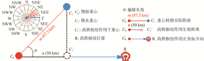
图1
高铁枢纽驱动下城市空间扩展效应原理示意图
Fig. 1
Schematic diagram of urban spatial expansion effect driven by high-speed rail hub
① 定义某一设站城市期始重心C0与高铁枢纽R连线方向为坐标系正坐标方向[33],测量重心转移实际连线(C0与C1连线)方向与高铁枢纽作用正坐标方向之间的夹角值θ来表征偏移量[34],偏移量用以解释统计期内的城市重心转移方向是否与高铁枢纽方向趋于一致,当θ值越接近于0°时,表示高铁枢纽对于城市重心转移程度的作用越明显,相反,当θ值接近于90°甚至大于90°时,则说明高铁枢纽对于城市重心转移程度的作用越小(图1)。② 利用余弦公式对城市重心实际转移距离m值进行分解,得到C1'点并测度高铁枢纽作用下城市重心转移生效距离数值n值,n值越大,反映高铁枢纽产生的作用效果越强,反之则越弱(图1)。③ 高铁枢纽作用下城市重心转移生效距离(n值)与城市重心转移实际距离(m值)的比值F(n/m)越大且越接近于1,说明高铁枢纽对城市重心转移的影响越明显,参与程度越高,反之,则说明高铁枢纽对城市重心转移的影响越不明显,参与程度越低。④ 将上述数值分别除以高铁枢纽对应设站城市统计期开始的建成区面积S和统计年份间隔时长Δt进行标准化处理,得到最终用于识别和分类的定量数值P,使不同高铁枢纽设站城市间计算得到的相对数值具有可比性,进而反映高铁枢纽驱动下城市空间扩展效应特征。测度模型示意图与公式如下:
式中:Xt、Yt、Xt+k和Yt+k分别为某一设站城市第t年和第t+k年城市重心的经度和纬度坐标;将设站城市分为i个次级区域;Cti为第t年第i块次级区域的建成区图斑面积(km2);Xi和Yi分别为第i块次级区域几何中心的经纬度坐标;公式(3)设地球为标准椭球体,且取地球平均半径为6371 km[35],D为重心转移前后点的实际距离;P为高铁枢纽驱动下城市重心转移指数;θ为转移前后重心连线与站—心(高铁站点与期始重心)连线之间的偏移夹角度数,依据ArcGIS以各设站城市建成区重心为原点,以东偏北11.25°为起始线,将研究区划分为16个夹角和大小相等的扇形区域并分别标注为不同方位,并利用ArcGIS 10.2中坐标几何(Coordinate Geometry, COGO)工具测量与提取得到长江经济带该设站城市重心偏移夹角数值指标θ[36](图1);S为该设站城市统计期始建成区面积;Δt为重心转移前后统计周期的时间间隔。
2.1.2 地理空间探测器
(1)因子探测:
(2)交互探测。交互探测表征两个影响因子对于高铁枢纽驱动城市空间扩展的作用关系,如高铁枢纽驱动下影响城市重心转移程度的M和N因素,通过空间叠加M和N形成新图层L,L的属性由M和N共同决定。通过比较M和N图层的因子影响力与L图层的因子影响力,判断两个因子交互作用对高铁枢纽参与城市重心转移程度的影响相比较于单个因子的影响是更强化还是更弱化。交互探测表达式为:若q(M∩N) < min(q(M), q(N)),表明因子M和N交互后非线性减弱;若min(q(M), q(N)) < q(M∩N) < max(q(M), q(N)),表明M和N交互后单线性减弱;若q(M∩N) > max(q(M), q(N))且q(M∩N) < q(M)+q(N),表明M和N交互后互相增强;若q(M∩N) > q(M)+q(N),表明M和N交互后非线性加强;若 q(M∩N) = q(M)+q(N),表明M和N相互独立。测度结果通过Geo Detector计算得出。
2.2 研究区概况
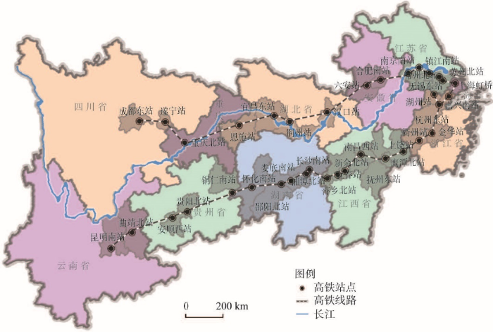
长江经济带横跨中国东西中三大区域,包括沪、苏、浙、皖、赣、鄂、湘、渝、川、滇和黔等11个省(直辖市),面积为205.23万km2,人口与经济总量皆处于全国前列,被称为世界上具有最多人口、最大产业规模、最完整城市体系的流域经济带。横跨长江经济带的沪汉蓉与沪昆两条高铁线是中国“八纵八横”高铁网络的重要干线,也是串联起长三角城市群、长江中游城市群和成渝城市群发展的重要通道。同时,由于同一城市中的不同站点由于高铁线路运距、运量、建成时间及其发展规模等存在一定差异,为排除不同线路、不同功能等高铁因素的影响,加强对高铁枢纽的建成时长、作业性质等其他变量的控制,重点研究不同城市间高铁驱动城市空间扩展效应的对比,本文以沪汉蓉线和沪昆线的37个高铁站点的地级市(包括直辖市和自治州府所在城市)为研究对象(图2)。
图2
2.3 数据采集与处理
选取长江经济带37个设站城市高铁站开通前后两个时间截断面(如苏州北站的高铁站建成运营时间节点2011年6月,设站城市高铁站开通前是指2011年,设站城市高铁站开通后是指2018年)探究城市空间重心转移与高铁枢纽之间的联系。数据采集包括分辨率为30 m的Landsat4-5、8TM遥感影像(2009年7月、2010年5月、2011年5月、2012年11月、2013年7月、2014年7月、2015年4月和2018年5月)及其他相关数据,借助ENVI软件分别将37个城市2个时相的遥感影像进行预处理获得长江经济带37个设站城市行政范围内数据(误差控制在一个像元以内),在ArcGIS 10.2的环境中,判读提取各城市的建成区,用于进行坐标计算的高铁站点坐标通过百度地图坐标拾取,分别计算37个设站城市的城市建成区的重心坐标,计算重心转移距离和转移方向。
2018年国家颁布的《关于推进高铁站周边区域合理开发建设的指导意见》指出,城市初期应重点开发新建高铁车站周边2 km以内区域并可适当控制预留远期发展空间;同时,关于高铁站对周边地区土地、产业等要素的影响范围的实证研究发现,高铁枢纽的直接影响范围在其周边3 km左右[40⇓-42]。综上,在判读提取各设站城市建成区的基础上,将建成区矢量数据转化为Grid数据,然后分别统计高铁枢纽建成前后2个时间截断面以高铁枢纽为中心周边3 km范围内建成区的面积,计算高铁枢纽地区的开发强度指数。高铁枢纽的城市内部交通路网信息通过矢量化长江经济带37个站点城市交通图(2018年)后得到,在此基础上,高铁枢纽整合度数据通过空间句法软件Depthmap 1.0计算得到。通过百度地图坐标拾取37个设站城市传统商业中心坐标,计算得到高铁枢纽距离指数。高铁枢纽城市的社会经济发展数据来源于《2017年城乡建设统计年鉴》和2018年37个站点城市的统计年鉴和统计公报。
3 高铁枢纽驱动下长江经济带城市空间扩展效应特征
依据GIS计算长江经济带37个高铁枢纽设站城市重心坐标,高铁站建成前后重心转移实际距离以及与重心连线与站—心连线夹角值,计算得到高铁站建成前后设站城市重心沿站—心连线移动距离数值,再除以各设站城市对应的建成区面积和统计年份周期的时长,然后进行比较分类。结果显示,重心转移指数P在0.02和0.09时,城市重心转移距离和站—心连线与重心转移连线间夹角度数有明显异动,基于此,将高铁枢纽驱动下城市重心转移程度分为3种类型:重心向高铁枢纽方向小幅度转移(0~0.02),重心向高铁枢纽方向中幅度转移(0.021~0.09)和重心向高铁枢纽方向大幅度转移(0.091~0.54)。其中,由于萍乡北站建成前后设站城市重心改变程度过大且与高铁枢纽联系十分不明显,站点观测价值不大,因此暂不将其列入下文特征观测范围。
3.1 城市重心向高铁枢纽方向大幅度转移特征
长江经济带设站城市高铁站建成前后重心向高铁枢纽方向转移幅度较大城市有14个,具体包括抚州东站、长沙南站、宜昌东站、娄底南站、遂宁站、上饶站、衢州站、金华站、邵阳北站、南昌西站、嘉兴南站、怀化南站、重庆北站和贵阳北站(图3)。
图3
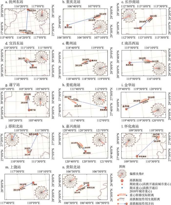
图3
长江经济带高铁开通后城市重心向高铁枢纽大幅度转移的设站城市分布
Fig. 3
Distribution of stations in cities whose center of gravity has greatly shifted to the hub of high-speed railway after the opening of high-speed railway in the Yangtze River Economic Belt
(1)从重心偏移方向θ值看,14个城市θ值最小值和最大值分别为0°和40°,均值为13°。其中,θ值在0°~6°有上饶站、衢州站、金华站、宜昌东站和嘉兴南站5个高铁枢纽,θ值在6.1°~16°有遂宁站、重庆北站、抚州东站、贵阳北站、南昌西站和长沙南站6个高铁枢纽,θ值在16.1°~40°有娄底南站、怀化南站和邵阳北站3个高铁枢纽。可见,这14个城市重心转移方向均属于正半轴方向且偏移夹角普遍较小,表明这些城市空间扩展受高铁枢纽影响比较明显,城市重心向高铁枢纽呈大幅度转移态势。
(2)从重心转移生效距离n值看,14个城市n值最大值和最小值分别为13.01 km和2.14 km,均值约为8.58 km。其中,n值在2.14~7.50 km有抚州东站、上饶站、邵阳北站、遂宁站和衢州站5个高铁枢纽,n值在7.51~11 km有嘉兴南站、宜昌东站、怀化南站、金华站和长沙南站5个高铁枢纽,n值在11.01~13.01 km有南昌西站、重庆北站、贵阳北站和娄底南站4个高铁枢纽。可见,这些城市在高铁枢纽驱动下重心转移生效距离均较大,表明高铁枢纽对这些城市空间扩展的作用力凸显,成为有效推进城市格局的重构与重塑的动力[43]。
(3)从城市重心转移生效距离(n值)和城市重心转移实际距离(m值)的比值F(n/m)看,14个城市中F(n/m)值最大值与最小值分别为1和0.77,均值为0.96。其中,F(n/m)值在0.77~0.95有邵阳北站、娄底南站和怀化南站3个高铁枢纽,F(n/m)值在0.96~0.98有长沙南站、南昌西站、贵阳北站和抚州东站4个高铁枢纽,F(n/m)值在0.99~1有衢州站、嘉兴南站、金华站、重庆北站、宜昌东站、上饶站和遂宁站7个高铁枢纽。可见,这些城市在高铁枢纽作用下城市重心转移生效距离(n值)和城市重心转移实际距离(m值)的比值均较大且接近于1,表明城市高铁枢纽对城市重心转移产生的作用程度均较大。
3.2 城市重心向高铁枢纽方向中幅度转移特征
长江经济带设站城市高铁站建成前后重心中幅度转移的城市总计13个,具体包括安顺西站、杭州东站、镇江南站、新余北站、湘潭北站、苏州北站、曲靖北站、南京南站、昆明南站、湖州站、合肥南站、汉口站和荆州站(图4)。
图4
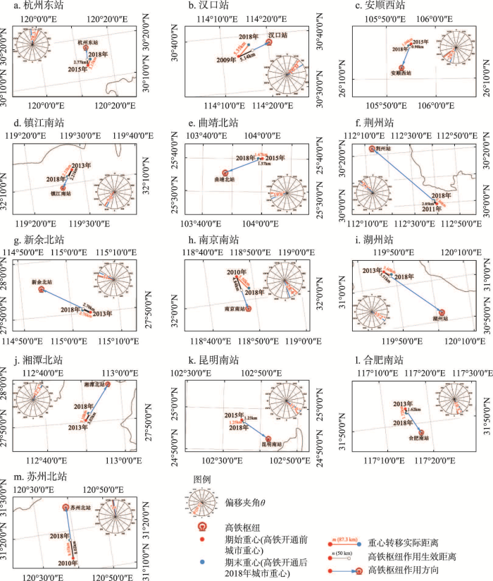
图4
长江经济带高铁开通后城市重心向高铁枢纽中幅度转移的设站城市分布
Fig. 4
Distribution of stations in cities whose center of gravity has medium amplitude shifted to the hub of high-speed railway after the opening of high-speed railway in the Yangtze River Economic Belt
(1)从重心偏移方向θ值看,这13个城市θ值最小值和最大值分别为2°和29.5°,均值为15.4°。其中,θ值在2°~11°之间的有苏州北站、荆州站、镇江南站、新余北站和昆明南站5个高铁枢纽,θ值在11.1°~16°有湘潭北站、湖州站和汉口站3个高铁枢纽,θ值在16.1°~29.5°之间的有合肥南站、曲靖北站、杭州东站、南京南站和安顺西站5个高铁枢纽。可见,这些城市的重心转移方向与高铁枢纽方向出现一定程度的偏离,偏移夹角增大,城市空间面向高铁枢纽地区扩展的指向性减弱。
(2)从重心转移生效距离n值看,这13个城市n值最大值和最小值分别为8.02 km和0.90 km,均值约为3.1 km。其中,n值在0.90~2.50 km有安顺西站、昆明南站、合肥南站、镇江南站和曲靖北站5个高铁枢纽,n值在2.51~3.50 km有杭州东站、荆州站、湘潭北站和新余北站4个高铁枢纽,n值在3.51~8.02 km有湖州站、南京南站、汉口站和苏州北站4个高铁枢纽。可见,这些城市在高铁枢纽作用下重心转移距离均较大,但与大幅度转移的城市相比,仍存在一定的差距,表明高铁枢纽对于这类城市空间扩展产生的影响力也在变小。
(3)从城市重心转移生效距离n值和城市重心转移实际距离m值的比值F(n/m)看,13个城市F(n/m)值最大值与最小值分别为0.99和0.87,均值为0.95。其中,F(n/m)值在0.87~0.95有南京南站、杭州东站、安顺西站、曲靖北站和合肥南站5个高铁枢纽,F(n/m)值在0.96~0.98有汉口站、湖州站、湘潭北站和新余北站4个高铁枢纽,F(n/m)值在0.99~1有昆明南站、镇江南站、苏州北站和荆州站4个高铁枢纽。可见,这些城市高铁枢纽对城市重心转移产生的作用力均较大,但F(n/m)值在0.96~1之间的高铁枢纽数量少于大幅度转移的城市,作用力与之相比也较小。
3.3 城市重心向高铁枢纽方向小幅度转移特征
长江经济带设站城市高铁站建成前后重心小幅度转移的城市共计9个,具体包括常州北站、鹰潭北站、宜春站、无锡东站、铜仁南站、上海虹桥站、六安站、恩施站和成都东站(图5)。
图5
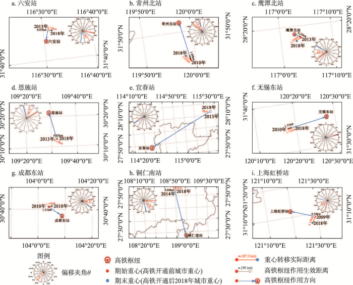
图5
长江经济带高铁开通后城市重心向高铁枢纽小幅度转移的设站城市分布
Fig. 5
Distribution of stations in cities whose center of gravity has small amplitude shifted to the hub of high-speed railway after the opening of high-speed railway in the Yangtze River Economic Belt
(1)从重心偏移方向θ值看,9个城市θ值最小值和最大值分别为0°和87°,均值为53.3°。其中,θ值在0°~45°有常州北站、无锡东站和宜春站3个高铁枢纽,θ值在45.1°~70°有成都东站和鹰潭北站2个高铁枢纽,θ值在70.1°~87°有上海虹桥站、六安站、恩施站和铜仁南站4个高铁枢纽。可见,这些城市偏移夹角与大、中幅度转移城市相比较大,且趋近于90°,但城市间偏移夹角数值差距较大,表明城市重心转移偏离高铁枢纽地区方向,受高铁枢纽影响不明显。
(2)从重心转移生效距离n值看,这9个城市n值最大值和最小值分别为1.71 km和0 km,均值约为0.63 km。其中,n值在0~0.4 km有宜春站、恩施站、铜仁南站、六安站和鹰潭北站5个高铁枢纽,n值在0.5~1.3 km有成都东站和上海虹桥站2个高铁枢纽,n值在1.31~1.71 km有常州北站和无锡东站2个高铁枢纽。可见,这些城市在高铁枢纽作用下重心转移距离均较小,受高铁枢纽影响不明显。
(3)从城市重心转移生效距离n值和城市重心转移实际距离m值的比值F(n/m)看,9个城市的F(n/m)值最大值与最小值分别为0.99和0,均值为0.38。其中,F(n/m)值在0~0.25有宜春站、六安站、恩施站、鹰潭北站和上海虹桥站5个高铁枢纽,F(n/m)值在0.26~0.80有铜仁南站和成都东站2个高铁枢纽,F(n/m)值在0.81~0.99有常州北站和无锡东站2个高铁枢纽。可见,这些城市在高铁枢纽作用下城市重心转移生效距离(n值)和城市重心转移实际距离(m值)的比值均较小,表明城市高铁枢纽对城市重心转移产生作用力均较小。
综上,高铁枢纽作用下城市空间扩展效应的特征可归纳为3个方面(表1)。
表1 高铁枢纽驱动下长江经济带城市空间扩展效应特征
Tab. 1
| 转移程度 | 偏移夹角(θ) | 高铁枢纽作用生效距离(n) | 高铁枢纽作用程度(F(n/m)) | 特点 | 高铁枢纽名称及数量 |
|---|---|---|---|---|---|
| 大幅度转移 | 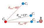 | 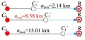 | 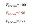 | ① 这些城市重心转移偏移夹角均较小 ② 向高铁枢纽地区转移距离较大 ③ 距离比值较大,且接近于1,城市重心转移受高铁枢纽的作用程度均较大 ④ 高铁枢纽驱动下城市重心大幅度转移的城市空间扩展呈现明显的“有的放矢”的特征,城市重心明显向着高铁枢纽的“靶心”方向转移 | 抚州东站、长沙南站、宜昌东站、娄底南站、遂宁站、上饶站、衢州站、金华站、邵阳北站、南昌西站、嘉兴南站、怀化南站、重庆北站、贵阳北站等14个高铁枢纽 |
| 中幅度转移 | 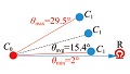 | 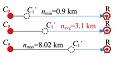 | 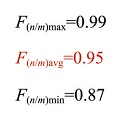 | ① 这些城市重心偏移夹角相比于大幅度向高铁枢纽转移城市偏大 ② 向高铁枢纽方向转移距离偏小 ③ 距离比值较大 ④ 城市重心转移受高铁枢纽影响不如大幅度向高铁枢纽方向转移的城市明显,指向性不够明显,处于待发展状态,呈现出“扩展萌芽”的特征 | 安顺西站、杭州东站、镇江南站、新余北站、湘潭北站、苏州北站、曲靖北站、南京南站、昆明南站、湖州站、合肥南站、汉口站和荆州站等13个高铁枢纽 |
| 小幅度转移 | 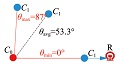 | 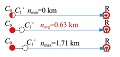 | 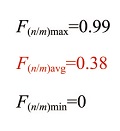 | ① 这些城市重心偏移夹角相比于大、中幅度向高铁枢纽转移城市都偏大 ② 向高铁枢纽方向转移距离偏小 ③ 距离比值较小 ④ 重心小幅度向高铁枢纽方向转移的城市空间扩展与高铁枢纽呈现“粘连关系不显著”的特征 | 常州北站、鹰潭北站、宜春站、无锡东站、铜仁南站、上海虹桥站、六安站、恩施站、成都东站等9个高铁枢纽 |
| 备注 | θmax指偏移夹角最大值 θavg指偏移夹角平均值 θmin指偏移夹角最小值 | nmax指高铁枢纽作用下重心转移生效距离最大值 navg指高铁枢纽作用下重心转移生效距离平均值 nmin指高铁枢纽作用下重心转移生效距离最小值 | F(n/m)max指生效距离与实际距离比值的最大值 F(n/m)avg指生效距离与实际距离比值的平均值 F(n/m)min指高生效距离与实际距离比值的最小值 | 距离比值指的是高铁枢纽作用下生效距离(n值)与城市重心转移实际距离(m值)的比值 | _ |
(1)重心向高铁枢纽方向大幅度转移的城市类型呈明显的“有的放矢”状态,主要表现在城市重心沿高铁枢纽方向转移的偏移夹角θ值较小,上饶站的θ值最小,θmin为0°,邵阳北站的θ值最大,θmax为40°,重心偏移夹角均值θavg仅为13°。沿高铁枢纽方向的生效距离n值较大,抚州东站的n值最小,nmin为2.14 km,南昌西站的n值最大,nmax为13.01 km,重心沿高铁枢纽方向的n值均值navg为8.58 km。生效距离与实际距离的比值F(n/m)较大且接近于1(表1),邵阳北站的比值最小,F(n/m)min为0.77,上饶站的比值最大,F(n/m)max为1,生效距离与实际距离比值的均值F(n/m)avg为0.96。这类城市的发展看重高铁枢纽带来的崭新机遇,努力把高铁枢纽的发展潜力内化为城市发展的潜力,处于快速城市化中的高铁枢纽承担了带动城市发展和空间扩展的重要任务。一方面,城市化进程推动了高铁枢纽的发展,为高铁站建设提供了充足的资金、人力等条件;另一方面,高铁枢纽为城市发展指明了新的方向,成为城市实现经济增长和产业升级的突破口之一,城市政府和市场发展的焦点与高铁枢纽地区重合度逐渐增强。
(2)重心向高铁枢纽方向中幅度转移的城市类型呈明显的“扩展萌芽”状态,主要表现在城市重心沿高铁枢纽方向转移的偏移夹角θ值较小,苏州北站的θ值最小,θmin为2°,安顺西站的θ值最大,θmax为29.5°,重心偏移夹角均值θavg为15.4°。沿高铁枢纽方向的生效距离值n值较大,安顺西站的n值最小,nmin为0.90 km,苏州北站的n值最大,nmax为8.02 km,重心沿高铁枢纽方向的n值均值navg为3.1 km。生效距离n值与实际距离m值的比值F(n/m)较大(表1),安顺西站的比值最小,F(n/m)min为0.87,荆州站、镇江南站和苏州北站的比值均较大,F(n/m)max为1,生效距离与实际距离比值的均值F(n/m)avg为0.96。但与重心向高铁枢纽方向大幅度转移的城市类型相比,城市重心向高铁枢纽方向转移的指向性不够明显,处于待发展状态,城市空间扩展与高铁枢纽的关系尚处于“扩展萌芽”阶段。
(3)重心向高铁枢纽方向小幅度转移的城市类型呈现与高铁枢纽“粘连关系不显著”状态,主要表现在城市重心沿高铁枢纽方向转移的偏移夹角θ值较大,宜春站的θ值最小,θmin为2°,六安站的θ值最大,θmax为87°,重心偏移夹角均值θavg为53.3°。沿高铁枢纽方向的生效距离值n值较小,宜春站的n值最小,nmin为0 km,无锡东站的n值最大,nmax为1.71 km,重心沿高铁枢纽方向的n值均值navg为0.63 km。生效距离与实际距离的比值F(n/m)较小(表1),宜春站的比值最小,F(n/m)min为0,无锡东站比值较大,F(n/m)max为0.99,生效距离与实际距离比值的均值F(n/m)avg为0.38。这类小幅度重心转移的城市城镇化水平多处于前期平缓和后期减缓的阶段,这两个阶段城市空间扩展的动力有限,这些城市一部分依托新的高铁枢纽形成新的城市功能区并发挥作用还需要一定的时间,如六安站等;另一部分属于在传统中心区旧站基础上建设的高铁枢纽,承担主要任务是加强城市中心的发展与更新,整体特征表现为高铁枢纽对城市空间扩展的拉动力也较小,高铁枢纽没有明显引起城市的重心转移,如上海虹桥站等。
4 高铁枢纽驱动下长江经济带城市空间扩展效应的作用机制
4.1 高铁枢纽驱动下城市空间扩展效应的影响要素识别
高铁枢纽驱动城市空间扩展效应特征表明,高铁枢纽对城市的影响并不局限于枢纽区域,而是依托高铁枢纽推动新区建设和郊区化等城市化进程,进而促进城市空间扩展和结构调整,为城市空间重构提供动力和机遇[44],但本文研究发现,高铁枢纽驱动长江经济带设站城市的空间扩展效应分异明显,为进一步揭示效应分异的关键驱动因子及作用机制,本文构建长江经济带高铁枢纽驱动城市空间扩展效应的影响机理框架。
(1)城市规模、城市外部可达性、城市发展水平和城市化等城市能级要素会对高铁枢纽驱动的城市空间扩展效应产生不同程度的影响[44]。高铁枢纽为沿线设站城市带来空间扩展效应由于高铁“再分配作用”机制产生差异,规模大、发展水平高的城市因“虹吸效应”带来生产要素的集聚加速城市空间扩展进程,反之扩展缓慢。因此,城市能级(ζ1)维度选取表征城市规模并影响高铁枢纽驱动城市重心转移程度的要素包括城市等级(X1)、城镇化率(X2)、三产占比(X3)、GDP(X4)和外部可达性变化率(X5)等5个指标。
(2)不同高铁枢纽等级、土地开发强度与投用运营时长等高铁枢纽发育程度要素影响着高铁枢纽驱动城市空间扩展的生效过程。高铁枢纽运营时长与经济、人流要素积聚程度成正比[45],即高铁枢纽运营一段时间后,逐步融入并承担起城市的功能,进而推动城市空间扩展。因此,高铁枢纽地区发育程度(ζ2)维度从空间和时间两个层面进行表征,其中,空间层面选取高铁枢纽等级(X8)和土地开发强度指数(X6),时间层面选择高铁枢纽投用运营时长(X7);高铁枢纽的车站等级及建成面积的增加是枢纽地区发育的直观表现,用高铁枢纽的开发强度指数表示,用于表征高铁枢纽地区的发育程度和速度[22],开发强度指数(Expand Intensity Index, EII)是指将增长面积标准化后,用来表征和比较城市某一单元面积变化的指标量[26]。
(3)高铁枢纽区位与可达性等站—城关系要素对城市空间扩展产生一定影响[46]。高铁枢纽内部可达性水平对旅客和功能要素的吸引力产生一定影响,进而影响着高铁枢纽是否向城市功能聚集中心成功转变[47-48];另外,高铁枢纽因位置不同致使其承担的城市功能有所差异,位于城市中心的高铁枢纽成为推动城市更新、促进城市复兴的重要依托,实现城市内部空间填充式增长;而位于城市边缘或外围的高铁枢纽则大部分为飞地式的新区建设发展。因此,站—城关系(ζ3)维度选取城市范围内高铁枢纽的可达性(X10)和高铁枢纽的选址区位(X9)两个指标,其中,高铁枢纽的可达性对城市与高铁枢纽之间资金、人口交流的速度产生影响,通过空间句法的全局整合度指数来解释城市内部可达性[49];高铁枢纽的选址区位是高铁枢纽的重要属性之一,距离指数是用于表征高铁枢纽距离城市中心的近远程度指标[29],一般呈负相关,即高铁枢纽距城市中心距离越近,城市扩张越容易发生[50]。
(5)从城市能级(ζ1)、高铁枢纽发育程度(ζ2)、站—城关系(ζ3)和政府政策(ζ4)等4个维度构建影响长江经济带高铁枢纽驱动城市空间扩展效应的指标体系(表2),并运用地理探测器分析高铁枢纽驱动下城市空间扩展效应的作用机制。
表2 影响要素探测指标体系
Tab. 2
| 维度层 | 探测因子 | 作用方向 | 变量解释及赋值计算说明 |
|---|---|---|---|
| 城市能级(ζ1) | 城市等级(X1) | + | 依据国务院《关于调整城市规模划分标准的通知》,将城市划分为超大城市、特大城市、大城市、中等城市和小城市5个等级,分别取值5、4、3、2、1 |
| 城镇化水平增长率(X2) | + | 城镇人口/总人口(%) | |
| 三产占比增长率(X3) | + | 第三产业增加值占城市国民生产总值(%) | |
| GDP增长率(X4) | + | 长江经济带37个城市GDP变化率 | |
| 城市外部可达性变化率 (X5) | + | 运用时间成本栅格法测算有无高铁条件下长江经济带37个城市交通外部可达性变化率 | |
| 高铁枢纽发育程度 (ζ2) | 枢纽土地开发强度(X6) | + | 式中:ΔUi为某一时段城市建成区面积变化数量;Δt为重心转移前后统计周期的时间间隔;TLA为研究单元总面积;EII为开发强度指数,即土地扩展强度指数,用来研究城市某一单元面积扩展特征的指标,表征城市单元空间开发的速度和程度[22]。本文用来识别以高铁枢纽为中心的3 km [40⇓-42]以内的土地面积开发强度系数 |
| 枢纽投用运营时长(X7) | + | 统计期始到统计期末的年份数(年) | |
| 枢纽等级(X8) | + | 枢纽等级变量是综合《全国铁路车站等级核定办法》《全国铁路中长期规划(2016—2030)》和各交通局年鉴、车站客流量、发车班次、站台面数量等资料整理所得[42] | |
| 站—城关系(ζ3) | 枢纽选址区位(X9) | - | 式中:d为高铁枢纽到城市中心(城市传统商业中心)的地理距离;S为统计期始设站城市建成区面积;Q为距离指数,可清晰地观察比较高铁枢纽的区位条件[29]。依据距离指数将高铁站划分为城市中心站、边缘站和外围站,分别取值3、2、1 |
| 枢纽城市内部可达性(X10) | + | 式中:Ii为整合度;m为城市系统中单元空间的个数; | |
| 政府政策(ζ4) | 枢纽政策多元性(X11) | + | 枢纽政策多元性=定位等级系数+规划功能系数+政策导向型产业复合度系数+政府重大投资项目系数 式中:定位等级系数代表高铁新城规划中对自身等级和层次的定位[51],定位越高,取值越大;规划功能系数代表高铁新城规划承担各类区域功能的多样化程度,功能种类越多,取值越大;政策导向型产业复合度=政府产业政策具体程度×产业复合度,值越大,代表政府政策对高铁枢纽产业的引导作用越大,反之,则越小;相关投资政策用政府引导下高铁枢纽相关的重大工程项目数表示 |
注:各指数均用自然间断点法进行分级处理。
4.2 设站城市重心转移关键驱动因子及其交互作用
地理探测器因子探测q值结果为:枢纽政策多元性(0.395)>城市外部可达性变化率(0.224)>枢纽城市内部可达性(0.210)>枢纽等级(0.120)>枢纽选址区位(0.091)>城市等级(0.080)>枢纽土地开发强度(0.074)>枢纽投用运营时长(0.070)>GDP增长率(0.030)>三产占比增长率(0.024)>城镇化水平增长率(0.022),均位于[0,1]区间,表明本文所选探测因子对高铁枢纽驱动下空间扩展效应具有不同程度的解释效果[39]。其中,枢纽政策多元性、城市外部可达性变化率、枢纽城市内部可达性和枢纽等级的q值位居前4位,分别属于政府政策(ζ4)、城市能级(ζ1)、站—城关系(ζ3)和高铁枢纽发育程度(ζ2)等4个维度,表明这4个维度均有影响因子对设站城市重心转移的作用明显。由于交互作用能更清楚地揭示各因素共同作用下的影响力是否受其他因素的制约,以及是否可增强高铁枢纽地区诱发城市空间扩展的能力,本文进一步对11个驱动因子进行交互分析(表3)。
表3 驱动因子交互作用探测结果
Tab. 3
| 驱动因子 | 政策 多元 | 城市外 部可达 | 城市内 部可达 | 枢纽 等级 | 选址 区位 | 城市 等级 | 土地 开发 | 投用 运营 | GDP | 三产 占比 | 城镇化 水平 |
|---|---|---|---|---|---|---|---|---|---|---|---|
| 政策多元 | 0.395 | ||||||||||
| 外部可达 | 0.738 | 0.224 | |||||||||
| 内部可达 | 0.453 | 0.440 | 0.210 | ||||||||
| 枢纽等级 | 0.459 | 0.425 | 0.376 | 0.120 | |||||||
| 选址区位 | 0.448 | 0.316 | 0.315 | 0.400 | 0.091 | ||||||
| 城市等级 | 0.594 | 0.490 | 0.295 | 0.380 | 0.249 | 0.080 | |||||
| 开发强度 | 0.771 | 0.548 | 0.524 | 0.235 | 0.399 | 0.740 | 0.074 | ||||
| 投用运营 | 0.669 | 0.452 | 0.408 | 0.407 | 0.289 | 0.278 | 0.188 | 0.070 | |||
| GDP | 0.633 | 0.350 | 0.266 | 0.377 | 0.160 | 0.185 | 0.390 | 0.287 | 0.030 | ||
| 三产占比 | 0.777 | 0.736 | 0.773 | 0.225 | 0.423 | 0.330 | 0.187 | 0.222 | 0.329 | 0.024 | |
| 城镇化水平 | 0.422 | 0.288 | 0.375 | 0.215 | 0.187 | 0.159 | 0.273 | 0.154 | 0.159 | 0.207 | 0.022 |
由表3可知,枢纽政策多元性、城市外部可达性变化率、枢纽城市内部可达性和枢纽等级等11个驱动因子两两共同作用后的影响力显著大于单因子影响力。① 城市能级维度(ζ1)的城市外部可达性变化率和城市等级2个驱动因子的解释力最强,且两者与城市三产占比增加、城镇化水平和GDP增长率等反映城市规模与发展水平指标的交互作用最为明显,枢纽政策多元性与城市三产占比增长交互后因子影响力为0.777(表3)。② 高铁枢纽发育程度维度(ζ2)的枢纽等级和枢纽土地开发强度2个驱动因子的解释力最强,两者交互后的因子影响力为0.235,较高于两者与其余因子间的交互作用,且两者与枢纽投用运营时长等反映枢纽自身发展潜力指标的交互作用更为明显(表3),分别为0.407和0.188。③ 站—城关系维度(ζ3)的枢纽选址区位和枢纽城市内部可达性2个因子的解释力最强,两者与枢纽土地开发强度、三产占比增长等其余3个维度具体指标间交互作用后的解释力均较强(表3),反映出站—城关系与枢纽土地开发强度、三产占比增加等指标间相互增强的关系。最后,政府政策维度(ζ4)的枢纽政策多元性指标对高铁枢纽驱动城市扩展效应的解释力最为明显,且与其余因子间的交互作用后的影响力均显著提升,反映枢纽政策多元性与其他指标均存在相互增强的关系。表3显示,影响高铁驱动城市扩展效应的4个主要维度中均存在单因子解释力较强且与其它因子间交互后发挥主导作用的关键驱动因子。基于此,本文对城市能级维度(ζ1)的“城市外部可达性变化率”和“城市等级”,高铁枢纽发育程度维度(ζ2)的“枢纽等级”和“枢纽土地开发强度”,站—城关系维度(ζ3)的“城市内部可达性”和“枢纽选址区位”,以及政府政策维度(ζ4)的“枢纽政策多元性”等7个关键性驱动因子做进一步的影响机制分析。
4.3 高铁枢纽驱动下城市空间扩展的驱动机制分析
4.3.1 城市能级是城市空间向高铁枢纽扩展的推动力
在城市能级维度(ζ1)中,城市外部可达性变化率和城市等级是高铁枢纽驱动城市空间扩展的两个关键性驱动因素,两者与城市三产占比增加、城镇化水平和GDP增长率等城市能级维度其余指标间的交互作用显著,充分反映出城市能级对高铁枢纽驱动城市空间扩展效应的推动作用。
(1)城市外部可达性变化率q值为0.224,属于第2位的主要影响因子。国内高铁建设处于城镇化快速发展和上升的阶段,尤其在城际联系愈加高铁化的背景下,城际联系的空间阻力逐步缩小,城市外部可达性正在不断改善[53],高铁枢纽“站”的作用不仅仅局限于城际的交通节点,同时因外部可达性的提升有利于加速高铁枢纽地区在城际间的资金、技术和劳动力等经济要素流动[51],枢纽间链接力愈加强大,高铁枢纽地区成为区域网络中的“关键节点”,使其企业和人口在高铁枢纽地区不断聚集,逐步成为城市新的商务中心,进而推动城市重心大幅度变化。如高铁开通使苏州北站枢纽成为承接上海虹桥国际开放枢纽交通流、商务流和会展流的重要区域,增强商务功能集聚力,成为吸引中高收入群体创业与居住的、商务型的苏州城市副中心,并逐渐发展为一个功能综合的高铁新城。苏州北站的城市外部可达性变化率为0.43,苏州北站高铁枢纽驱动城市重心发生中等幅度的转移,高铁枢纽作用下重心转移生效距离n值为8.02 km,F(n/m)值接近为1。可见,高铁改善城市外部可达性的同时,使部分高铁枢纽地区成为城市内部重要的功能区域,高铁枢纽驱动城市空间扩展的效应凸显。根据本文研究,高铁枢纽驱动城市重心进行大规模转移的城市外部可达性变化率大部分位于0.43~0.48之间,如上饶站、娄底南站和贵阳北站等均属于城市重心大幅度向高铁枢纽转移的类型,P值均较高,分别为0.17、0.54和0.24,而城市外部可达性变化率分别为0.464、0.461和0.482。
(2)城市等级q值为0.080,是属于前6位的关键驱动因子,对于推动城市空间向高铁枢纽扩展具有显著影响。城市等级是国家综合人口等要素进行的城市类型划分,一定程度上反映了城市发展的速度与程度。高铁促进城际间经济再分配,进而提升等级较高城市影响力,吸引更大范围的人流和资本的集聚[48]。如南昌西站提升了九龙湖乃至南昌市的功能和价值,南昌作为省会城市,依托于“中部崛起”和“长江中游城市群”等国家战略,处于城镇化水平快速增长阶段,同时由于南昌西站的人流汇聚让九龙湖人气大涨,使九龙湖高铁新城成为日渐繁华的商业中心,九龙湖公园、地铁、医院、学校、酒店和金融机构等配套逐渐完善,为做强“大南昌”提供了新的动力。因此,围绕南昌西站开展的九龙湖新城建设符合南昌市的城市发展规律,南昌高铁枢纽的建设极大推动了城市空间向南昌西站扩展,城市重心转移的夹角θ值较小,仅为18°,高铁枢纽作用下重心转移生效距离n值为13.01 km,高铁枢纽作用下F(n/m)值达0.97,由此,南昌西站推动江西省会城市进入了新一轮开发建设。相反,一些等级相对较低的设站城市近邻大城市,因大城市的虹吸作用导致自身的生产要素外流,反而削弱自身的发展能力[2]。如六安站的建设加速了东西方向的高铁客流,受邻近省会大城市合肥的虹吸影响,六安站区建设速度缓慢,整个城市空间向高铁枢纽扩展效果不明显,其重心转移P值仅为0.003。可见,中等城市空间扩展和格局演变程度正在呈“两极分化”趋势,一部分城市正抓住高铁枢纽发展载体积极推进城市发展[54],而另一部分还处于发展“休眠期”,但总体表现为城市等级越高,赋予城市更大的辐射范围,容易出现扩大腹地现象,城市向高铁枢纽地区的空间扩展越明显。
4.3.2 高铁枢纽发育程度是城市空间向高铁枢纽扩展的牵引力
高铁枢纽发育程度维度(ζ2)的解释力主要通过高铁枢纽等级和枢纽土地开发强度等两个因素表现出来,且两者与枢纽投用运营时长等高铁枢纽发育程度维度指标间的交互作用明显,两者均属于关键驱动因子,充分反映出高铁枢纽发育程度牵引着城市空间向高铁枢纽地区扩展。
(1)高铁枢纽等级决定了城市空间向高铁枢纽地区扩展的程度,q值为0.120,是处于第4位的关键驱动因子。高铁枢纽等级是反映高铁枢纽发育程度一个重要属性,较高等级高铁枢纽带来更高的日均客流量,促进高铁枢纽更好地发挥“触媒”作用并加速高铁枢纽地区的开发进程[46],更快速地集聚城市的资金、人口和产业,进而逐步演变成为城市功能的组成部分。如长沙南站为一等站,2018年车站客流量达5621万人次,为接纳如此巨大的人流并服务其需求,长沙南站枢纽及其周边地区加速布局配套基础设施空间并逐步引进会展中心、星级酒店和高端写字楼等业态,形成一定规模的现代服务业聚集的新区,使城市重心向高铁枢纽方向大幅度转移,城市重心转移的偏移夹角θ值较小,仅为15°,高铁枢纽作用下重心转移生效距离n值为10.96 km,F(n/m)值高达0.96。相反,新余北站作为二等站,2018年客流量仅为143万人次,高铁没有给高铁枢纽地区带来较高的人流,小规模客流对于办公、酒店以及零售等空间需求较小,配套商业及服务设施规模较小,则城市向高铁枢纽重心转移程度较小。可见,高铁枢纽周边开发程度随着枢纽等级的增长而加深,高铁枢纽“新城”空间逐步融入城市并承担起更多城市功能,进而推动城市发展和空间格局演变。因此,高铁枢纽等级在很大程度上牵引着城市的发展。
(2)高铁枢纽地区的土地开发强度影响着城市空间扩展效应。高铁枢纽周边地区作为城市用地构成的一部分,其用地面积的增加与城市建成区总体面积的增加呈一定的正相关关系,实现高铁枢纽地区土地有效整合与开发,提升枢纽地区公共服务设施和空间环境质量,可以更好地消化被吸引至此大量的人流,提高高铁枢纽的利用效率,使其转变为多样化城市功能的聚集空间[18]。如衢州站、南昌西站、长沙南站、金华站和嘉兴南站的枢纽用地开发强度指数均较高,分别为0.0363、0.0335、0.0518、0.0367和0.0351,这些站区周边的公共服务设施用地、商业和商务等用地类型得到了合理布局和充分开发。如衢州站周围集聚了衢州市图书馆、衢州公寓和万达广场等配套设施,为城市发展提供了优质的发展空间。相应地,这些高铁枢纽对城市重心转移的影响也较大,重心转移指数P值分别为0.17、0.14、0.16、0.14和0.10,均属于城市重心向高铁枢纽方向大幅度转移的设站城市类型。因此,围绕高铁枢纽开发建设为城市提供越优质的公共空间,吸引并承担起城市乃至更大范围内的人流、物流的集聚活动,牵引城市空间向高铁枢纽扩展效应越明显。
4.3.3 站—城关系是城市空间向高铁枢纽扩展的催化剂
站—城关系维度(ζ3)包括高铁枢纽所在城市内部可达性因子和枢纽选址区位因子,且两者与枢纽土地开发强度、三产占比增长等指标交互作用后的解释力均较强,充分反映出站—城关系决定着高铁枢纽驱动下城市空间扩展进程的快慢,发挥“催化剂”作用。
(1)高铁枢纽地区可达性对城市空间扩展具有较大的决定作用。高铁枢纽承担着时空压缩“最后一公里”的可达性效应[55],高铁枢纽良好的可达性条件对城市空间扩展具有很强的催化作用[4]。城市内部可达性条件较好的高铁枢纽地区有助于其与城市之间的资金、人员流动,进而成为城市经济、人流和土地开发程度较高的集聚地段[2],如重庆北站可达性指数为0.102,位居前列,通过城市地铁交通、公交车线路与城市中心产生便捷的联系,重庆北站成为理想的新城开发区,带动了城市空间向北扩展,致使重庆的城市重心逐渐向北移动。相反,城市内部可达性较差的高铁枢纽地区则抑制了城市空间向高铁枢纽扩展的程度和速度,导致城市重心转移方向偏离站—心连线方向,如六安站和恩施站的可达性指数仅分别为0.061和0.012,可达性较差,则两个城市的重心转移连线与站—心连线夹角θ值分别为87°和76.5°,重心转移指数仅分别为0.30和0.04。研究发现,长江经济带城市重心属于大幅度和中幅度转移的设站城市中,可达性较好和一般的高铁枢纽数量为18个,占比为72%。因此,较好的可达性提升推进城市的资金、人流向高铁枢纽集聚的效率,催化高铁枢纽新中心的形成[2,50]。
(2)高铁枢纽的区位对城市空间扩展具有一定的催化作用。高铁枢纽地区选址过于偏远或偏于中心均会影响城市向高铁枢纽地区扩展。高铁距离指数较大,表明高铁站远离城市中心,如铜仁南站和宜春站分别属于外围站和边缘站,距离指数分别为18.50和2.99,导致城市中心到高铁枢纽的通行成本显著增加,限制了人口和资金转移,致使铜仁南站和宜春站高铁枢纽的周边开发量较小,城市空间扩展效应不明显,重心转移指数仅分别为0.003和0。另外,距离指数过小也会限制高铁枢纽周边开发[29],如属于核心站的上海虹桥站、杭州东站、成都东站和常州北站等,距离指数仅分别为0.47、0.43、0.48和0.17,此时高铁枢纽周边开发已经较为成熟,城市开发程度和发育程度也较高,可开发空间面积变少,高铁枢纽对城市空间扩展的效应不明显,重心转移幅度较小,上海虹桥站和成都东站的重心转移指数分别仅为0.002和0.007。与此相反,合适的选址将强化高铁枢纽对城市空间扩展的引导作用,统计发现,长江经济带距离指数在0.93~2.14之间的高铁枢纽产生的城市空间扩展效应最明显。在重心大幅度转移的城市中,距离指数位于0.93~2.14之间的高铁枢纽数达到10个,占比为71%。因此,较低和较高的距离指数均会限制高铁枢纽驱动城市空间扩展的能力,而适当的区位选择能更好地发挥高铁枢纽驱动城市空间扩展的作用[56]。
4.3.4 政府政策是城市空间向高铁枢纽扩展的指导力
政府政策(ζ4)因素作为指导力,决定着高铁枢纽驱动城市空间扩展效应能否实现,q值为0.395,是排名第1的关键驱动因子,与其他指标间的交互作用也最为显著。国内城市中高铁枢纽地区空间形态大多是“自上而下”的规划定位和政府强势推动下的结果[48,51],政府规划定位、产业政策和项目投资对于城市资金、人员是否向高铁枢纽地区的倾斜具有重要的调控作用。研究发现,城市重心向高铁枢纽方向大幅度转移的城市中,73%的高铁枢纽地区有“城市副中心”“城市功能区”等较高的规划定位、多样的产业政策和较多的重大项目投资。如宜昌政府规划将宜昌东站高铁枢纽地区作为承担宜昌东部的金融、商贸、交通枢纽等功能的城市新经济增长点,并将其打造为城市副中心,形成宜昌市东部门户的标志性形象地区。宜昌东站高铁枢纽驱动城市重心发生大幅度的转移,高铁枢纽作用下重心转移生效距离n值为7.84 km,偏移夹角θ值仅为5.5°,F(n/m)值接近为1,可见,政府政策对高铁枢纽驱动城市空间扩展效应影响凸显。
但同样属于对高铁枢纽地区有较高规划定位的一些城市重心向高铁枢纽方向却呈小幅度转移的特征,地方政府在力求重塑城市中心体系,打造另一个城市副中心的同时会忽略高铁枢纽的区位、客流量和城市内部交通联系等要素的约束,国内大多数设置于城市边缘和外围高铁枢纽地区存在产业政策缺位、综合配套不完善、与其自身所处的发展阶段和地理区位不匹配等问题[51]。如宜春站等高铁新城将高铁站周边区域视为房地产“圈地运动”的沃土,使高铁站区的产业向纯房地产化的结构转变。这类高铁新城因产业单一、就业机会少、难以吸引人流而最终沦为“鬼城”,致使高铁枢纽驱动城市空间扩展效应难以生效。可见,政府政策的调控能力是影响高铁枢纽驱动城市空间扩展效应的重要因素之一,城市政府对于高铁枢纽的规划定位需及时调整,较高的规划定位并不能完全保障高铁枢纽顺利带动城市的发展,合理调控各种影响要素,能更好地发挥政府政策的指导力。
4.3.5 作用机制分析
高铁枢纽驱动下长江经济带城市空间扩展效应分异是城市能级、高铁枢纽发育程度、站—城关系和政府政策等4大驱动要素共同参与、相互作用的结果(图6)。从驱动力看,① 在城市能级维度中,城市等级、城镇化率、GDP、三产占比和城市外部可达性变化率等要素间交互作用明显,共同汇成了高铁枢纽驱动城市空间扩展过程中的推动合力,其中,城市外部可达性变化率和城市等级的分力较大,作用效果最明显。② 在高铁枢纽发育程度维度中,枢纽等级、投用运营时长和枢纽土地开发强度等要素间交互作用明显,共同汇成了高铁枢纽驱动城市空间扩展过程中的牵引合力,其中,枢纽等级的分力最大,作用效果最明显。③ 在站—城关系维度中,枢纽可达性和枢纽选址区位等要素间交互作用明显,共同汇成了高铁枢纽驱动城市空间扩展过程中的催化合力,其中,枢纽可达性的分力最大,作用效果最明显。④ 政府政策直接通过对于高铁枢纽地区所制定的多元化政策产生指导力,且与城市能级、站—城关系和高铁枢纽发育程度维度均存在明显的交互关系,作用效果显著。
图6
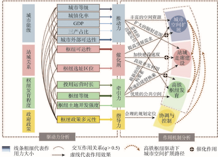
图6
长江经济带高铁枢纽驱动城市空间扩展的驱动力及作用机制
Fig. 6
Driving mechanism of urban spatial expansion induced by high-speed rail along the Yangtze River Economic Belt
从作用机制看,城市能级、高铁枢纽发育程度、站—城关系和政府政策4个维度在高铁枢纽驱动城市空间扩展过程中分别发挥了推动力、牵引力、催化力和指导力作用,且4种驱动力交互作用。由图6可知,① 城市能级的等级越高,则发挥推动力越强。城市能级等级越高的城市,则对空间资源诉求越大,按照赋予城市原有中心逐渐扩大的辐射范围和寻求疏解的路径,通过“站—城走廊”实现城市功能结构、空间资源的重构和再分配,推动城市空间资源向高铁枢纽方向扩展。② 高铁枢纽地区发育程度越好,则发挥牵引力越强。发育程度良好的高铁枢纽,产生更优质的公共空间,为城市空间转型发展提供了崭新结构要素,并依托“站—城走廊”牵引着城市空间向高铁枢纽地区扩展,逐步成为城市转型发展过程中新的增长极。③ 合适的站—城关系更能发挥“催化剂”作用。站—城距离越近,则高铁枢纽地区可拓展空间有限;而站—城距离越远,则通行成本显著增加,抑制了城市空间扩展;由此,只有合适的站—城距离,则高铁枢纽地区不仅拥有可拓展空间,且具有理想的通行成本,通过强化“站—城走廊”的建设速度和质量,催化城市中心人流、物流向高铁枢纽集聚,使高铁枢纽地区得以有效开发利用,最终成为城市新中心。④ 政府政策通过对于高铁枢纽地区的多元政策支持产生指导力,政府通过合理的规划定位、产业和投资引导等可以协调和控制着高铁枢纽驱动城市空间扩展效应的生效过程。
5 结论与讨论
(1)长江经济带37个城市高铁枢纽空间扩展效应分为3个等级且分异明显。① 高铁枢纽驱动城市进行大幅度重心转移,城市发展呈明显的“有的放矢”状态。高铁枢纽在城市重心转移过程中的作用力与参与程度都较强,且沿高铁枢纽方向的转移距离都较大,偏移夹角较小,城市重心明显向着高铁枢纽这一“靶心方向”转移。② 高铁枢纽驱动城市进行中幅度转移,城市向高铁枢纽地区发展呈“扩展萌芽”特征。高铁枢纽在城市重心转移过程中的作用力和参与程度较弱,沿高铁枢纽方向的转移距离较短,城市空间扩展虽面向高铁枢纽方向,但偏移夹角均较大,城市发展虽然与高铁枢纽有一定的联动,但指向性并不明显,还处于待发展的状态。③ 高铁枢纽驱动城市进行小幅度转移,城市重心转移偏离高铁枢纽方向,偏离角度较大且接近90°,城市发展并没有与高铁枢纽进行粘连,高铁枢纽驱动城市进行重心转移的作用力和作用程度都极弱,呈“粘连关系不显著”状态。
(2)高铁枢纽驱动城市空间扩展的作用机制主要表现在城市能级、高铁枢纽发育程度、站—城关系和政府政策等4个维度11个因子。① 城市能级在高铁枢纽驱动城市空间扩展过程中发挥了“推动力”作用,其中,解释能力最强的是城市外部可达性变化率,其次是城市等级;城市能级决定了高铁枢纽周边地区的发展基础条件,城市应结合自身经济水平布局高铁拉动城市发展的规划,求大求快的发展路径可能适得其反。② 高铁枢纽发育程度在高铁枢纽驱动城市空间扩展过程中发挥了“牵引力”作用。高铁枢纽发育维度主要包含枢纽等级、枢纽土地开发强度和枢纽投用运营时长3个因子,其中,作用力较大的是高铁枢纽等级;与高铁枢纽土地开发强度因子和投用运营时长因子共同发挥对城市空间扩展的牵引作用,高铁枢纽等级、设站城市土地开发政策、开发时序的优先级越高,高铁枢纽附近土地扩张的速度和程度越快,并通过提供更优质的公共服务设施牵引城市向高铁枢纽方向扩展。③ 站—城关系在高铁枢纽驱动城市空间扩展过程中发挥了“催化剂”作用。合适的区位选择降低高铁枢纽地区通行成本并提高其可开发利用程度,从而催化高铁枢纽驱动城市空间扩展的作用;同时,可达性对城市空间扩展也发挥着较大的催化作用,交通网络的完整性、通达性对于高铁枢纽地区与城市之间的资金、人员交流可以起到促进作用,从而加快城市空间向高铁枢纽地区扩展的进程。最后,政府政策作为协调和控制高铁枢纽驱动城市空间扩展的指导力,高铁枢纽地区合理的规划定位可以为后续的效应实现减小阻力,提供更大的可能性。
本文对于推进高铁枢纽开发建设,实现城市空间有效拓展和内部结构整合优化有重要的现实意义。① 科学认识高铁枢纽驱动城市空间扩展效应可为地方政府、交通局、高铁新城管委会等相关部门进行高铁枢纽开发可行性评价、明确高铁新城规划实施阶段提供重要的决策依据,进而强化政府对高铁枢纽改变区域联系格局、优化城市空间结构、带动城市人口和经济增长等优势作用的认识,减少处于待发展状态、单一交通发展模式为主的城市高铁枢纽地区数量,充分发挥高铁枢纽带动城市发展的“正能量”。② 高铁枢纽驱动城市扩展效应尚不明显的城市可依据“规划调控、枢纽牵引、城市推动、站—城关系催化”的驱动路径,结合城市功能区划、人口资源环境条件、区位优势、财力等发展实际,厘清建设重点和时序,着重解决重大投资项目引导、枢纽周边地区开发、站—城交通走廊连接等关键问题。③ 根据不同城市和高铁枢纽特点,制定差异化的高铁新城开发政策,如“枢纽先行、带动城市”“城市先行、带动枢纽”“城市与枢纽并行”等,避免高铁“鬼城”出现,实现高铁建设与城市发展的良性互动和可持续发展,为实现交通强国战略提供重要支撑。
本文构建的高铁枢纽驱动城市重心转移指数,为定量测度高铁枢纽驱动城市空间扩展提供了方法支撑,丰富城市地理学开展城市空间结构演化的理论和方法。另外,本文利用地理探测器的交互探测分析影响高铁枢纽驱动城市空间扩展效应的具体因子两两间的协同和增强关系,侧重于不同影响因子间影响力大小横向比较,但对影响因素间内生关系本文尚未做出深度分析。城市发展与交通设施存在着内生关系,即城市发展与交通设施建设具有互为促进作用的内生关系。由于中国处于城镇化快速发展阶段,大部分城市的高铁枢纽承载着推动城市发展与空间扩展的重任[2],因此,本文侧重分析高铁枢纽对城市空间扩展作用,而高铁枢纽与城市发展的内生关系在后续研究中作为重点研究方向。
参考文献
Basic rules and key paths for high-quality development of the new urbanization in China
DOI:10.11821/dlyj020180445
[本文引用: 3]

The high-quality development of the new urbanization in China is focused on man-earth harmony, people-oriented principle, low-carbon, ecology, innovation, wisdom and safety. It is an organic unity of high quality citizenization, infrastructure, living environment, urban construction, public service and urban management. Promoting the new urbanization is an important way for China to build a moderately prosperous society in all respects and achieve modernization basically, and it is an important way to realize the strategy of rural revitalization. To promote the development of China's new urbanization, we need to follow the four stage rule and gradual development rule. To realize the strategy transformation of new urbanization, it is necessary to make more changes: from the quantitative to the quality-oriented, from the "one step" to "step by step" in realizing our goals, from radical to gradual, from inducing "negative effect" to releasing the "positive energy", from passive to active, from "land-oriented" to "people-oriented". The current situation and background conditions of China's urbanization are very different from one place to another. Thus, we should avoid "one-size-fits-all" in promoting the development of new urbanization. Adhering to the principle of adapting local conditions and appropriate conditions, the paper divides the new urbanization area into five major types, including urban agglomeration region (I), major grain-producing region (II), farming, forestry, and animal husbandry region (III), linked poverty alleviation region (IV), and ethnic autonomous region (V), which are further divided into 47 sub-regions. The urbanization development mode between different regions and different subregions cannot be copied from each other, and we need to implement some diversified and differentiated models. According to the main functions of different types of urbanization regions, the different development policies of urbanization should be formulated, and development goals and priorities should be put forward according to local conditions, and the classification guidance should be proposed according to the appropriate conditions. The key paths to promote the high-quality development of China's new urbanization include: enhance the overall synergy of high-quality development and improve the quality of urban agglomeration development; promote the integrated development of industrial and urban areas and the equalization of basic urban public services, and improve the quality of urban development; propel integrated development between urban and rural areas and accelerate the revitalization of rural areas; highlight the main functions of urbanization quality development in different types of areas in accordance with local conditions; innovate institutional mechanisms and ensure that high-quality development is carried out throughout the trial process of new urbanization; standardize small towns with distinctive features and lay a solid foundation for the high-quality development of new urbanization; strengthen the analysis and regulation of the capacity of resources and environment for the high-quality development of new urbanization.
中国新型城镇化高质量发展的规律性与重点方向
DOI:10.11821/dlyj020180445
[本文引用: 3]
中国新型城镇化高质量发展是一种人地和谐、高效低碳、生态环保、节约创新、智慧平安的质量提升型城镇化,是高质量的城市建设、高质量的基础设施、高质量的公共服务、高质量的人居环境、高质量的城市管理和高质量的市民化的有机统一。高质量推进新型城镇化发展需要遵循城镇化发展的四阶段性规律和渐进式规律,实现新型城镇化由数量型向质量型、由“一步到位”向“分步到位”、由激进式向渐进式、由诱发“负效应”向释放“正能量”、由被动性向主动型、由“地为本”向“人为本”的战略转型。考虑到中国新型城镇化发展的地域差异显著,新型城镇化高质量发展客观上要因地制宜、因类指导,可将全国新型城镇化高质量发展区域划分为城市群地区(Ⅰ)、粮食主产区(Ⅱ)、农林牧地区(Ⅲ)、连片扶贫区(Ⅳ)、民族自治区(Ⅴ)共5大高质量发展类型区和47个亚区。未来推进中国新型城镇化高质量发展的重点路径包括:增强新型城镇化高质量发展的整体协同性,提高城市群发展质量;推动产城深度融合发展,加快实现基本公共服务均等化,提升城市发展品质与质量;推动城乡深度融合发展,在新型城镇化高质量发展中实现乡村振兴;突出因地制宜,明确不同类型地区城镇化高质量发展的主体功能;创新体制机制,全过程推进城镇化高质量发展;量力而行,以特取胜,规范建设特色小镇,夯实新型城镇化高质量发展的基石;把新型城镇化高质量发展与区域资源环境承载力及高质量保护有机结合起来。
Responses of China's urban master planning under HSR effects
高铁效应下我国城市总体规划的应对
HSR promote urban spatial restructuring as a structural element: A case study of Lyon
解析高铁作为城市空间重组的结构性要素: 法国里昂案例分析
Interaction between railway terminals and urban functionalities in mega cities: An extended analysis based on the node-place model
特大城市铁路客运枢纽与城市功能互动关系: 基于节点—场所模型的扩展分析
The enlightenment of the Japanese station-city development to the construction of high-speed railway new town in China: A case study of the New Yokohama station
日本站城一体化开发对我国高铁新城建设的启示: 以新横滨站为例
High-speed rail station and urban spatial evolution: Review and introspection
DOI:10.22217/upi URL [本文引用: 3]
高速铁路站点与城市空间演化: 述评与反思
Effect of high speed railway network on spatial structure of urban agglomeration
试论高速铁路网建设对城镇群空间结构的影响
The research review and prospect of the impact on urban and regional space of high-speed rail
高速铁路对城市与区域空间影响的研究述评与展望
The high-speed rail challenge for big intermediate cities: A national, regional and local perspective
DOI:10.1016/j.cities.2009.07.001 URL [本文引用: 1]
The development effect of high-speed rail stations and implications for California
High-speed rail in Europe: Experience and issues for future development
DOI:10.1007/s001680050037 URL [本文引用: 1]
Gaining insight in the development potential of station areas: A decade of node-place modelling in the Netherlands
DOI:10.1080/02697450701296247 URL [本文引用: 1]
Spatial-temporal analysis of urban growth and transportation in Jeddah City, Saudi Arabia
DOI:10.1016/j.cities.2012.04.008 URL [本文引用: 1]
Territorial cohesion impacts of high-speed rail at different planning levels
DOI:10.1016/j.jtrangeo.2011.10.008 URL [本文引用: 1]
High-speed rail transportation hub development mode: From transport complex to urban complex
高速铁路时代大型铁路枢纽的发展模式探讨: 从“交通综合体”到“城市综合体”
Governing urban developments around high-speed rail stations: Experiences from four European cities
高速铁路车站周边地区城市开发管理: 四个欧洲城市的经验研究
Review and evaluation of high-speed railways impact on urban space
高速铁路对城市空间影响研究述评
The synergy of high-speed railway station areas and urban space development
站点地区开发与城市空间的协同发展
A spatial analysis model for measuring the rate of land use change
DOI:10.11849/zrzyxb.2002.05.002
[本文引用: 1]
Through subdividing the spatial changes of each land use type into three categories of components,i.e.,the unchanged part,the converted part and the newly-increased part,this paper finds out that the two existing models for measuring the rate of land use changes have serious limitations.The traditional quantity analysis model only considers the quantitative change of land use but completely neglects the spatial changes of land use.The GIS-based dynamic degree model would seriously underestimate the change rate of those land use with rapid growth,in par-ticular urban land use because it only takes the conversion process into account but neglects the spatial expansion process of land use change.Therefore,a new spatial analysis model is then pro-posed to modify those limitations and to improve the measuring precision.Secondly,the proposed spatial analysis model is applied in a detailed case study on land use change in urban fringe of Beijing and the measuring results from the3models are compared which substantially demon-strate that the proposed spatial analysis model can more precisely measure the dynamic change rate of land use.
土地利用动态变化的空间分析测算模型
Urban spatial expansion and its influence factors based on RS/GIS: A case study in Changsha
基于RS/GIS的长沙市城市空间扩展及影响因素
A GIS based model of urban land use growth in Beijing
DOI:10.11821/xb200004003
[本文引用: 1]
Based on the land use maps of Beijing in 1982, 1992 and 1997, its spatial and temporal process of urban land use growth was analyzed through spatial clustering and historical morphological approaches. The growth intensity index (GII), was employed instead of growth speed to describe the spatial differentiation of urban land use growth. Assisted by spatial analysis techniques of GIS, the average GIIs per year (AGIIPY) of 155 communes or towns during 1982~1992 and 1992~1997 were calculated and then classified through the Natural Breaks method, and the spatial differentiation maps of urban land use growth in Beijing during 1982~1992 and 1992~1997 were made. This paper found: (1) Industrial land is the most important element of urban land use growth in Beijing, and its contribution rate is on the increase, which is different from the general Western urban growth model driven by residential expansion. Since 1982, the industrial land had been keeping expanded at the average rate of 24~25 km<sup>2</sup> per year. It is extraordinary high especially during the 1992~1997 period, while that of residential land and urban land use dropped by 59% and 24%, to 3 4 km<sup>2</sup> per year and 29 8 km<sup>2</sup> per year respectively. Thus, the contribution rate of industrial land to urban land use growth increased from 64 91% in 1982~1992 to 80 67% in 1992~1997. (2) The spatial pattern of urban land use growth in Beijing was in distinct concentric sprawl. With the growth centers’ gradual shift from the inner to outside, the new added urban land use were increased in distinct concentric zones and continually encroached upon the green spaces among the central mass and those “dispersed constellations”. The total area of green spaces for isolating built up areas in General Plan of Beijing, was 314 km<sup>2</sup> in 1958, reduced to 260 km<sup>2</sup> in 1983 and 160 km<sup>2</sup> in 1993. The concentric sprawl pattern seriously destroyed the spatial structure of “dispersed constellations” designed by the General Plan of Beijing, and also badly worsened the regional ecological environment. (3) The growth axes of urban land use in the southern and eastern part of Beijing had stepped into their decline period. The southern and eastern part of Beijing is located in the North China Plain and have advantages in urban development space, economic and transport communication, etc., so that they are determined as the main urban development areas and direction by the latest General Plan (1991~2010). But this paper found, the two major growth axes of urban land use along the Beijing Tian Jin and Beijing Shen Zhen highways in the southern and eastern part of Beijing, had stepped into their decline period during 1992~1997. Their AGIIPY decreased from 1 63 and 1 58 during 1982~1992 to 0 86 and 0 67 respectively, and the spatial growth pattern have also switched from vigorous axial expansion to fill in among axes.
基于GIS的北京城市土地利用扩展模式
DOI:10.11821/xb200004003
[本文引用: 1]
采用GIS空间分析技术,对1982~1997年期间北京城市土地利用扩展的时空过程进行空间聚类和历史形态分析。证实工业用地的高速外向扩展是北京城市土地利用规模“超常膨胀”的主要原因。
Space syntax expand intensity index and its applications to quantitative analysis of urban expansion
DOI:10.11821/dlxb201608002
[本文引用: 3]
Expand intensity index (EII) is an index commonly used to characterize the extent and speed of urban expansion. In other words, it is simply used to describe and analyze the physical spatial change from the perspective of urban area. But this index only represents the result of urban expansion neglecting the feeling of people to space and the underlying mechanisms of urban expansion. Moreover, an in-depth study is ignored on the evolving pattern of urban space and cannot reflect human activities in urban space. This paper presents a new expansion intensity index based on space syntax by considering the driving effect of transport network on urban expansion, namely space syntax expand intensity Index (SS-EII). SS-EII can reflect the syntactic variables about spatial clustering and dispersion and analyze the changes of spatial accessibility. Compared to the conventional expand intensity index, SS-EII not only cares about the result of urban expansion, but also captures the effect of transportation on the pattern and direction of urban expansion as well as the feeling of human to urban space. With Cotton Lake Town in Guangdong Province, China as an example, SS-EII is utilized to compare expansion speeds of built-up areas in different directions. It can be concluded that the result based on SS-EII is consistent to the actual situation of urban expansion and the correlation coefficient with EII is higher than 0.95.
基于空间句法的扩张强度指数及其在城镇扩展分析中的应用
DOI:10.11821/dlxb201608002
[本文引用: 3]
扩张强度指数(Expand Intensity Index, EII)是目前城市扩展数量特征研究的常用指标,用以表征城市扩张程度和速度,但该指标是从城市扩张的结果,即从城市用地面积变化角度对物质空间变化的简单描述与分析,忽略了人在空间中的感受,未能从城市扩张的动因角度揭示城市扩张特征,缺乏对城市外部空间形态演变模式的深入研究,不能反映人在城市扩展空间上的活动。本文从交通网络对城市扩张的驱动作用入手,基于空间句法,提出一种新的扩张强度指数——基于空间句法的扩张强度指数(Space Syntax Expand Intensity Index, SS-EII),SS-EII包涵可反映空间集聚和离散程度的句法变量,可用于分析空间可达性的变化等情况。与传统扩张强度指数相比,SS-EII是基于空间句法从城市扩张的驱动力方面计算扩张强度,不仅关注城市扩张的结果,同时关注交通对城市扩张模式、方向的导向作用和人主观感知下城市空间的变化。将SS-EII应用于广东省棉湖镇2002-2014年期间的城镇扩展特征分析中,研究结果表明,SS-EII可用于分析比较建成区不同方向的扩张速率与建设状况,其计算结果与棉湖镇建成区实际扩张情况相符,与EII相关度R<sup>2</sup>达0.95以上。
Multi-dimensional analysis of urban expansion patterns and their driving forces based on the center of gravity-GTWR model: A case study of the Beijing-Tianjin-Hebei urban agglomeration
DOI:10.11821/dlxb201806007
[本文引用: 3]
Research into urban expansion patterns and their driving forces is of great significance. Under the background of the integrated development of the Beijing-Tianjin-Hebei (Jing-Jin-Ji) urban agglomeration, it is important to study the temporal and spatial patterns of urban land expansion and the driving forces development. This paper uses land-use data of the Jing-Jin-Ji urban agglomeration from 1990 to 2015 and reveals the multi-dimensional characteristics of the urban land expansion patterns. We then combine the urban spatial interaction and the spatial and temporal nonstationarity of the urban land expansion process and build the center of gravity-geographically and temporally weighted regression (GTWR) model by coupling the center of gravity model with the GTWR model. Using the center of gravity-GTWR model, we analyze the driving forces of urban land expansion at the city scale, and summarize the dominant mode and core driving forces of the Jing-Jin-Ji urban agglomeration. The results show that: (1) Between 1990 and 2015, the expansion intensity of the Jing-Jin-Ji urban agglomeration showed a down-up-down trend, and the peak period of expansion was in 2005-2010. Before 2005, high-speed development was seen in Beijing, Tianjin, Baoding, and Langfang, which were then followed by rapid development in Xingtai and Handan. (2) Although the center of gravity of cities in the Jing-Jin-Ji urban agglomeration showed a divergent trend, the local interaction between cities was enhanced, and the driving forces of urban land expansion showed a characteristic of spatial spillover. (3) The spatial development mode of the Jing-Jin-Ji urban agglomeration changed from a dual-core development mode to a multi-core development mode, which was made up of three function cores: the transportation core in the northern part, the economic development core in the central part, and the investment core in the southern part. The integrated development between functional cores led to the multi-core development mode. (4) The center of gravity-GTWR model analyzes urban land expansion as a space-time dynamic system. The model proved to be feasible in the analysis of the driving forces of urban land expansion.
基于重心-GTWR模型的京津冀城市群城镇扩展格局与驱动力多维解析
DOI:10.11821/dlxb201806007
[本文引用: 3]
城镇用地扩展格局及驱动力研究对城市群发展规划与决策具有重要意义。以京津冀地区为例,基于城镇用地扩展强度指数、城镇用地扩展差异指数、分形维数、土地城镇化率和重心转移模型,多维解析了城市群城镇用地扩展格局特征,并耦合重心转移模型和时空地理加权回归(GTWR)模型构建重心-GTWR模型,在对空间格局进行长时间序列多维度指标分析的基础上,运用该模型依序对其特征进行驱动力解读,进而总结凝练京津冀区域发展的主导模式与城市核心驱动力。主要结论为:① 1990-2015年,京津冀城市群城镇用地扩展强度呈现“下降—上升—下降”的趋势,高峰时期在2005-2010年,在2005年之前高速发展城市集中在北京、天津、保定和廊坊,2005年之后集中在邢台和邯郸;② 城市群城镇用地重心虽呈现出发散态势,但城市之间的局部相互作用力逐渐增强,城镇用地扩展驱动力表现出空间溢出特征;③ 京津冀城市群空间发展模式由以北京和天津为中心的双核发展模式向多核发展模式转变,并出现北部资源运输核心、中部经济发展核心和南部投资发展核心三大功能核心组团,城市群趋向于多核功能协同发展模式;④ 重心-GTWR模型结合了时空非平稳性和城市空间相互作用,将城市群城镇用地扩展作为一个时空变化系统进行分析,经验证,该模型在城镇用地扩展格局驱动力分析研究中具有可行性。
Spatiotemporal change and its driving factors of built-up land sprawl in Yangzhou city
Built-up land sprawl is the most drastic and visual manifestation of urban land-use change. Understanding spatiotemporal change of built-up land sprawl and its driving forces can reveal the inherent laws of urban sprawl, and thus scientifically regulate urban land use. In this study, we used multisource data (e.g., 30 m resolution Landsat images in 1995, 2000, 2005, 2010, and 2015) and socioeconomic data to analyze spatiotemporal changes of built-up land sprawl in Yangzhou City. Further, we employed the boosted regression tree method to quantify the effects of geographic, social and economic factors on such sprawl. Results showed that the built-up land area gradually increased from 725.4 km<sup>2</sup> in 1995 to 1076.5 km<sup>2</sup> in 2015. With the increasing urbanization, the spatial form of built-up land tended to be compact and regular, and the gravity coordinates also migrated accordingly, showing local attraction and linkage of municipal districts (e.g., Hanjiang and Guangling). Among geographic, social, and economic factors, geographic factors (e.g., altitude, the distance from the county core, the distance from built-up land) had the greatest influence on built-up land sprawl, with the relative influence gradually decreasing from 73.9% in 1995-2000 to 60.2% in 2010-2015. The influence of social and economic factors gradually increased from 5.2% and 20.9% in 1995-2000 to 7.9% and 31.9% in 2010-2015. Geographic factors (e.g., the distance from the county core and the distance from built-up land) generally had negative effect on built-up land sprawl, but the effects of social and economic factors were inconsistent. For example, population density, GDP per capita and fiscal revenue promoted built-up land sprawl, gross population inhibited it, and secondary industry first inhibited built-up land sprawl and then promoted it.
扬州城市建设用地扩张的时空演变特征及其驱动机制
建设用地扩张是城市土地利用变化中最剧烈、最直观的表现。探究其时空演变特征及其驱动力将有助于揭示城市空间扩张机理,促进城市用地调控的科学化。以快速城市化的中型城市——扬州市为例,基于多期Landsat遥感影像(1995、2000、2005、2010和2015年)、社会经济数据等资料,分析建设用地扩张的时空演变特征,进而利用增强回归树(boosted regression tree)方法,探讨城市化进程中地理空间、社会和经济因子对建设用地扩张的影响。研究发现,1995—2015年,建设用地面积从725.4 km<sup>2</sup>持续增加到1076.5 km<sup>2</sup>。随着城市化的推进,建设用地的空间形态趋于紧凑、形状变得规则,重心也随之转移,表现出市辖区的局部吸引和联动特征。在地理空间、社会和经济因子中,地理空间因子(如海拔、距县市核心区和建成区的距离)对建设用地扩张的影响最大,但其相对影响却从1995—2000年的73.9%逐渐下降到2010—2015年的60.2%;社会和经济因子的相对影响则呈增加的趋势,即1995—2000年的5.2%和20.9%分别增加到2010—2015年的7.9%和31.9%。地理空间因子(如距县市核心区和建成区的距离)对建设用地扩张的影响以抑制作用为主,但不同社会经济因子的作用呈现较大差异,例如,人口密度、人均GDP和财政收入能够促进建设用地的形成,人口数量表现为抑制作用,第二产业则为先抑制后促进的作用。
Analysis of influencing mechanism of urban growth using Geographical Detector
一种基于地理探测器的城镇扩展影响机理分析法
Study of spatio-temporal pattern and driving mechanism of urban land expansion in urban agglomeration: A case study of the Changsha-Zhuzhou-Xiangtan urban agglomeration
城市群城市用地扩张时空特征及驱动机制研究: 以长株潭城市群为例
Spatial evolution of high-speed railway station areas and planning response
高铁站点地区空间演化与规划应对
Looking for the balance between transport value of node and functional value of city: Discussing theory and practice in the development of airport area and high-speed rail station area
寻求节点交通价值与城市功能价值的平衡: 探讨国内外高铁车站与机场等交通枢纽地区发展的理论与实践
Influence of HSR station location on the development of surrounding areas: A case study of Beijing-Shanghai HSR and Wuhan-Guangzhou HSR.
高铁站区位对周边地区开发的影响研究: 基于京沪线和武广线的实证分析
Evaluating the impact of high-speed railway on urban land expansion based on multi-period difference-in-difference model
高速铁路对城市用地扩张的影响
Analysis the change of urban internal spatial structure based on the shift of city gravity in Dalian city
基于城市重心转移的大连市城市内部空间结构变化分析
The shifting pattern of a city center: Taking Beijing as an example
论城市重心转移规律: 以北京市为例
Location selection of high-speed train stations of Beijing-Shanghai line and urban development
京沪高铁站点选址与其所在城市发展解析
Research and implementation of robot tracking control system based on real time offset correction
实时修正偏移量的循迹机器人控制系统研究与实现
Discussion on the average radius of reference ellipsoid
关于参考椭球平均半径的探讨
The values of vegetation purified air and its measure in Xin'an city
西安市植被净化大气物质量的测定及其价值评价
Geographical detectors-based health risk assessment and its application in the neural tube defects study of the Heshun region, China
DOI:10.1080/13658810802443457 URL [本文引用: 1]
Environmental health risk detection with GeogDetector
Geodetector: Principle and prospective
DOI:10.11821/dlxb201701010
[本文引用: 2]
Spatial stratified heterogeneity is the spatial expression of natural and socio-economic process, which is an important approach for human to recognize nature since Aristotle. Geodetector is a new statistical method to detect spatial stratified heterogeneity and reveal the driving factors behind it. This method with no linear hypothesis has elegant form and definite physical meaning. Here is the basic idea behind Geodetector: assuming that the study area is divided into several subareas. The study area is characterized by spatial stratified heterogeneity if the sum of the variance of subareas is less than the regional total variance; and if the spatial distribution of the two variables tends to be consistent, there is statistical correlation between them. Q-statistic in Geodetector has already been applied in many fields of natural and social sciences which can be used to measure spatial stratified heterogeneity, detect explanatory factors and analyze the interactive relationship between variables. In this paper, the authors will illustrate the principle of Geodetector and summarize the characteristics and applications in order to facilitate the using of Geodetector and help readers to recognize, mine and utilize spatial stratified heterogeneity.
地理探测器: 原理与展望
DOI:10.11821/dlxb201701010
[本文引用: 2]
空间分异是自然和社会经济过程的空间表现,也是自亚里士多德以来人类认识自然的重要途径。地理探测器是探测空间分异性,以及揭示其背后驱动因子的一种新的统计学方法,此方法无线性假设,具有优雅的形式和明确的物理含义。基本思想是:假设研究区分为若干子区域,如果子区域的方差之和小于区域总方差,则存在空间分异性;如果两变量的空间分布趋于一致,则两者存在统计关联性。地理探测器q统计量,可用以度量空间分异性、探测解释因子、分析变量之间交互关系,已经在自然和社会科学多领域应用。本文阐述地理探测器的原理,并对其特点及应用进行了归纳总结,以利于读者方便灵活地使用地理探测器来认识、挖掘和利用空间分异性。
A study on characteristics of spatial development and construction of high-speed railway station areas: An empirical analysis based on the case of beijing-Shanghai high-speed railway line
高铁站点地区空间开发特征研究: 基于京沪高铁沿线案例的实证分析
Spatial distribution and clusters of industry nearby high-speed rail station: The case of Nanjing Station, Shanghai-nanjing motor train
DOI:10.13249/j.cnki.sgs.2012.03.301
[本文引用: 2]
The questionnaires are surveyed including the passengers’ travel destination, traffic mode choice and the travel distance, etc., in the Nanjing Station of Shanghai-Nanjing Intercity high-speed railway. Collecting the address, industry category, set-up time of 6 145 companies surrounding station within 3 000 m as the study samples, using spatial analysis methods, this article analyzes the distribution of industries and spatial clusters by high-speed railway station. The resluts are as follows. 1) Generally speaking, industry location has obvious circle structure around high-speed station. The company density shows a circle structure with the Nanjing Station as the center and 500 m as the buffer radius. The company density ascends to the top at 1 500-2 000 m, and has break in the point of 2 000 m far from the Nanjing Station. The wholesale and retail industry has the largest number, business service industry in second, science and technology service industry in third. Comparing industry proportion in each circle, we come to the conclution that business service industry, accommodation and catering industry increase gradually at 0-1 500 m, reduce significantly at 2 000 m, which confirms the high-speed railway passengers on business service industry and accommodation and catering industry needs a 1 500 m-radius concentration. 2) The trend of spatial industrial concentration is similar, decreasing with the distance. Owing to the different spatial scales, the location of wholesale and retail industry has most options; transportation industry and real estate industry tend to have a significant traffic location. The accommodation and catering industry, computer service industry, science and technology service industry as well as the resident service industry show homogeneous distribution based on the cluster distribution. 3) There is a significant difference in the spatial distribution of the industry, featured by “higher in the west and lower in the east”. The spatial distribution patterns are generally identified in three modes of concentration. The transportation industry and real estate industry have a "small scatter, large cluster" mode, that is, the spatial distribution of companies show relative concentration and form a single hotspot. The resident service industry, wholesale and retail industry as well as accommodation and catering industry present a “large scatter, large cluster” mode. Business service industry, science and technology service industry and computer service industry have a “large scatter, small cluster” mode. The results above confirm the Ripley' s K function analysis.
高铁站区产业空间分布及集聚特征: 以沪宁城际高铁南京站为例
DOI:10.13249/j.cnki.sgs.2012.03.301
[本文引用: 2]
分析沪宁城铁南京站乘客的出行距离特性,初步确定高铁站区圈层范围为3 000 m。以南京站周边3 000 m范围内6 145个企业的地址、行业隶属、成立时间等为研究数据,运用空间分析方法,探讨高铁站区产业的分布与空间集聚特征。 ① 从总体看,高铁站区产业的空间分布具有明显的圈层结构,以车站为中心,以500 m为缓冲半径,在1 500~2 000 m范围企业密度最大,2 000 m以外企业密度陡然降低。② 各行业空间集聚趋势类似,随着距离增大集聚程度降低。但空间尺度上存在差异,交通运输业和房地产业集聚现象更为明显,交通指向性显著;批发和零售业集聚峰值相对最大,在大范围上有分散分布的趋势。③ 各行业空间分异特征显著,整体呈现“东低西高”,空间分异特征大致存在以下三种模式,即“小分散、大集聚”、 “大分散、大集聚”、“大分散、小集聚”。
Industrial structure of high-speed railway station areas under the influence of location: Empirical evidences from POI data
DOI:10.11821/dlxb202108014
[本文引用: 3]
High-speed railway (HSR) station is regarded as a new type of space for driving urban economic growth, and studying its surrounding industrial structure is of great significance to guide the development of HSR station areas. In this paper, nine HSR stations with different locations and different levels in China are selected as the research object. The Point of Interest (POI) information data of 10 industries within 3000 m around the HSR station are used as the research basis. Based on the Ripley's K function, kernel density estimation and industrial indexes, the characteristics of industrial distribution of HSR station areas in different locations are explored. Our result indicates that when the grade of high-speed rail stations is the same, the farther the high-speed rail stations are from the city center, the smaller the total number of industrial POIs in the station area. Among 10 kinds of industries, the number of POIs in four types of industry, namely, shopping services, catering services, life services and companies, is much larger than that of other industries. Secondly, all industries in the HSR station areas show a significant agglomeration within an observation distance of 1500 m. In terms of the industrial agglomeration degree, the change of the central station is relatively gentle, the change of the urban station is the highest, and the change range is greater, and the regularity of new-town station is not obvious. Thirdly, the industrial agglomeration area of the central station is mainly distributed in the range of 0-2500 m around the high-speed rail station, the industrial agglomeration area of??the urban station is more obvious in the range of 500-2500 m, and the industrial agglomeration area of the new-town station is concentrated in the ranges of 0-1500 m and 2000-3000 m. Fourthly, the basic service industry and derivative service industry are mainly concentrated in the inner and the middle circle layers, and the related service industries are mainly distributed in the middle and the outer circle layers. The compound characteristics of the industries in each circle layer are obvious, and the farther away from the city center, the weaker the radiation effect on the industry, the more obviously the trend of industry decays. Finally, based on the research findings, it is believed that the government should pay more attention to the intensification of land development and the integration of industrial development while developing the industries in HSR station areas.
区位因素影响下高铁站区产业结构特征: 基于POI数据的实证分析
DOI:10.11821/dlxb202108014
[本文引用: 3]
高铁站被视为拉动城市经济增长的新型空间,研究其周边产业结构对指导高铁站区的开发具有重要意义。本文选取了全国范围内9个不同区位、不同等级的高铁站为研究对象,以高铁站周边3000 m范围内10类产业的POI信息作为研究数据,通过Ripley's K函数、核密度估计和产业指数等方法探索不同区位下高铁站区的产业结构特征。研究发现:① 当高铁站的等级规模相同时,高铁站距离城市中心越远,站区内产业POI总数一般就越少。其中,购物服务、餐饮服务、生活服务和公司企业4类产业的POI数量显著高于其他产业。② 所有高铁站区的产业在1500 m的观测距离内均呈现出显著的集聚分布特征。其中,中心站产业集聚程度的变化较为平缓,城区站产业集聚程度最高,变化幅度也更大,而新城站的规律特征不明显。③ 中心站的产业集聚区域主要分布在高铁站周边0~2500 m的范围内,城区站的产业集聚现象在500~2500 m范围内较为明显,而新城站的产业集聚区域则集中在0~1500 m、2000~3000 m的范围以内。④ 基本服务产业和衍生服务产业主要集中于内圈层和中间圈层,相关服务产业则主要分布在中间圈层和外圈层,各圈层内产业复合特征明显,且高铁站越远离城市中心,其对产业的辐射作用越弱,产业衰减趋势也越明显。基于以上结论,本文认为未来高铁站区的产业开发更应关注土地开发集约化和产业发展复合化。
National grand infrastructure construction and urban spatial development: A case study on high-speed railway and urban comprehensive transport hub.
国家大型基础设施建设与城市空间发展应对: 以高铁与城际综合交通枢纽为例
Overseas study progress of high speed rail's influences on regional and urban spatial development
境外高速铁路对区域和城市空间发展的影响研究进展
Spatial differentiation of industry in Shanghai Hongqiao integrated transportation hub area
上海虹桥综合交通枢纽地区产业空间分异变迁
High-speed rail and its impacts on the urban spatial dynamics in China: The background and analytical framework
高速铁路对城市空间演变的影响: 基于中国特征的分析思路
High-speed line airport connections in Europe: State-of-the-art study
Research framework of high-speed railway impact on urban space
高速铁路对城市空间影响的研究框架及实证
Research on urban morphology evolution based on fractal theory and space syntax: Taking the Fuzhou city as an example
基于分形理论和空间句法的城市形态演变研究: 以福州市为例
Integrated transfer system of high-speed rail hub based on sustainable transfer
基于绿色换乘的高铁枢纽接驳体系建构
Evaluation on planning of high-speed rail station area based on node-place model in Yangtze River Delta area
基于节点—场所模型的高铁站点地区规划评价: 以长三角地区为例
Land development of HSR station area and the formation of urban central function: A case study of beijing-Shanghai HSR and beijing-Guangzhou HSR.
高铁站区用地开发及其城市中心职能实现程度研究: 基于京沪、京广高铁的实证分析
A study on the accessibility of high-speed rail in China: A case of Yangtze River Delta
关于中国高速铁路可达性的研究: 以长三角为例
The missing missions and constructive proposal of China's HSR new town
我国高铁新城的使命缺失与建设建议
Spatial differentiation and influence mechanism of the connection-distribution performance of urban high-speed railway hub in the Yangtze River Economic Belt
DOI:10.11821/dlxb202108013
[本文引用: 1]
A transportation hub is the key link in the construction of the comprehensive three-dimensional transportation corridor of the Yangtze River Economic Belt (YREB), and it is the basic factor responsible for the promotion of this belt. A high-speed railway hub has the effect of "last kilometer of time-space compression" and is the key to building an efficient, convenient, modern, and comprehensive transportation system. Based on the principle of this effect, this study constructed a model for measuring the connection-distribution performance of the high-speed railway hub, determined the connection-distribution performance of the urban high-speed railway hub in the YREB, and analyzed its spatial differentiation characteristics, and further revealed the influencing mechanism of the connection-distribution performance of the high-speed railway hub. The main results are as follows: (1) the connection-distribution performance of the high-speed railway hub in the YREB presented an "olive type" grade structure with two small ends and a large middle section, that is, there are fewer high-speed railway stations with high performance and average performance, and there are more high-speed railway stations with good performance and medium performance. (2) The connection-distribution performance of the high-speed railway hub in this economic belt showed a regional differentiation pattern of "high in the east and low in the west" and "high in the north and low in the south", and showed an urban agglomeration differentiation pattern of "high in the core area and low in the marginal area". Moreover, spatial differences were prominent in the distribution of nine evaluation indexes of the connection-distribution performance of the high-speed railway hub. (3) GDP, urbanization rate, city level, station passenger flow and frequency of shuttle bus were key driving factors affecting the connection-distribution performance of the high-speed railway hub. At the same time, there were significant differences in the key driving factors for the connection-distribution performance grades of high-quality, good, medium and average levels.
长江经济带城市高铁枢纽接驳—集疏运绩效空间分异及机理
DOI:10.11821/dlxb202108013
[本文引用: 1]
作为长江经济带综合立体交通走廊建设的关键环节,交通枢纽是推动长江经济带发展的基础保障。高铁枢纽承载着“时空压缩最后一公里”效应,是构筑高效便捷的现代化综合交通体系的关键。首先诠释了高铁枢纽“时空压缩最后一公里”效应原理,其次构建高铁枢纽接驳—集疏运绩效指标体系,进而对长江经济带37个城市高铁枢纽的接驳—集疏运绩效进行测度,并分析绩效空间分异特征,最后揭示高铁枢纽接驳—集疏运绩效的影响机理。结果显示:① 长江经济带高铁枢纽接驳—集疏运绩效等级分异呈“橄榄型”结构,即优质绩效和一般绩效的高铁站数量较少,良好绩效和中等绩效的高铁站数量较多;② 地带分异呈“东高西低、北高南低”格局,而城市群分异则呈“核心高、边缘低”格局,且9个评价指标值空间差异明显;③ GDP、城镇化率、城市等级、车站客流量和发送班车次数是影响高铁枢纽接驳—集疏运绩效的关键驱动因子;同时,优质、良好、中等和一般等不同等级绩效的关键驱动因子存在显著差异。
Characteristics and mechanism of high speed rail-driven suburbanization in China: A case study of beijing-Shanghai high-speed rail
DOI:10.13249/j.cnki.sgs.2012.09.1041
[本文引用: 1]
The international theoretical and practical studies suggest that the construction of high-speed rail (HSR) usually influences the development of suburban area. In China, the large-scale construction of HSR, together with the rapid urbanization, makes such influence more complex and profound. In the development of HSR new town, the HSR station works as an "amplifier", thus it promotes suburbanization. In the case study of Beijing-Shanghai High-speed Rail, this article takes both quantitative and qualitative approaches to explore suburbanization’s patterns in HSR new town: 1) relatively active suburbanization in major cities; 2) exorbitant scale and expectation of urban construction; 3) rapidly shifted urban forms. From the perspectives of government, market and society, this article uses urban regime theory to analyze the inter-mechanism of HSR-driven suburbanization. In conclusion, selectivity and uncertainty of HSR’s suburbanization are proposed. This article also suggests that it is important to coordinate the locations and relationships of the high-speed railway and cities along the lines at a regional level. Furthermore, the development of HSR and urban space in the new towns should be integrated, and the public participation during the planning and development of HSR new towns should be strengthened. Therefore, the goal of sustainable suburban development by HSR can be reached.
高铁驱动中国城市郊区化的特征与机制研究: 以京沪高铁为例
DOI:10.13249/j.cnki.sgs.2012.09.1041
[本文引用: 1]
国际理论与实践表明高铁的建设能够推动城市郊区化的发展。现阶段中国高铁大规模建设,与快速城市化同步推进,使得这一影响更为深刻和复杂。在高铁新城形成的过程中,高铁站点发挥了一个“放大器”的功能,推动了以高铁新城为主体的城市郊区化进程。以京沪高铁为例,定性与定量相结合分析了以高铁新城为代表的郊区化模式特征:① 大城市相对主动的郊区化;② 规划建设的规模与定位偏高;③ 迅速改变城市原有空间格局等。从政府、市场和社会三者的角度,利用城市政体理论分析了高铁驱动城市郊区化的内在机制。最后指出高铁对于城市郊区化的带动效应存在着选择性和不确定性,应从区域层面对高铁沿线及周边城市的定位及关系进行协调,将高铁新城的选址、规划、开发和建设纳入到城市整体空间发展的脉络之中,同时应加强高铁新城规划的公众参与,从而更好的利用高铁驱动中国城市郊区化的可持续发展。
