

1 引言
铁路建设改变要素流动的时空关系及其配置效率,并进而影响经济社会发展与引导国土空间重塑。近年来,中国铁路网络快速发展,在路网规模及质量、技术标准与客货运量等方面均步入世界前列。2021年3月国务院下发《关于进一步做好铁路规划建设工作的意见》,要求严格控制既有高铁的平行线路建设,铁路设计时速与客流密度密切挂钩,注重高速铁路(简称“高铁”)与普通速度铁路(简称“普铁”)协调发展。随着中国铁路网络布局的不断完善,铁路新建速度开始放缓,中国高铁骨架网络已基本形成。2020年全国铁路和高铁投产新线较2019年分别同比下降41.89%和47.02%。按照国铁集团计划,2022年铁路新开通里程继续下降,预计投产新线3300 km,其中普速铁路约1900 km①(①数据来源:
交通建设与运输组织重塑区域空间结构一直是经济地理学的经典命题[1-2]。聚焦于铁路,相关研究包括:① 基于可达性的铁路空间效应评估。从效率与公平角度评估了跨国、国家和区域尺度上铁路修建所带来的时空压缩效应与可达性格局变化,并以此揭示铁路塑造空间结构的规律[3⇓⇓-6]。② 铁路发展对区域发展的影响。以出行时间、可达性等时空压缩效应指标为解释变量,探讨铁路发展对区域经济的影响,并通过经济增长在空间上的极化与扩散揭示铁路整合与重塑区域空间格局特征[7-8]。③ 基于铁路交通流的城市网络结构。“流空间”背景下,相较于可达性静态指标,反映经济社会功能联系的交通流更能准确揭示区域空间结构特征[9-10]。国内外学者基于中心流动理论与网络分析方法开始对铁路交通流支撑下城市网络结构[11⇓⇓-14]、铁路与其他交通方式支撑下的城市网络结构异同[15⇓-17]、铁路网络与经济社会空间组织的耦合[4,18]等议题展开研究,并呈方兴未艾之势。上述研究从多维视角深化了铁路网络演化及其对区域空间结构重塑效应的规律性认识,但整体仍侧重于基于可达性的静态分析,缺少基于“流空间”视角下区域整合效应的分析。高铁与普铁以其各自的技术经济优势承担了差异化运输需求,反映了差异化区域空间结构特征[19-20]。然而,现有研究多基于高铁和航空的比较视角展开,缺乏高铁与普铁的直接比较并将其延伸到对经济社会空间组织整合效应的研究,可能导致已有结果的片面性。
鉴于此,在高铁网络架构基本形成,追求高铁与普铁平衡与协调发展背景下,本文以地级行政区为基本单元,开展高铁与普铁空间运输联系比较并评估其对经济社会空间组织的整合效应,为优化铁路网布局、通过铁路网嵌入国家空间治理进而促进区域协调发展提供决策参考。
2 理论基础与研究方法
2.1 交通运输与区域空间结构耦合理论
理解基于铁路的功效运输联系及其区域整合效应差异化逻辑,需从交通运输与区域空间结构耦合理论方面进行把握。交通运输与区域空间结构耦合主要指交通运输系统与人地关系地域系统的交互作用过程及其要素集散空间形态。从基础设施与空间福利视角出发,金凤君认为功效空间是一种福利空间,其实质是满足人类安全、健康和发展需求的地域空间[21]。科学有序的功效空间组织是实现人类社会可持续发展的关键。交通运输通过可达性与运输联系(交通流)作用于要素空间集散进而影响功效空间结构(图1),如交通经济带[2]、交通走廊[22]等。一方面,交通技术进步、高速交通运营所产生的时空压缩效应,通过促进要素流动、拓展空间相互作用范围与深度,进而引起要素集散和可达性格局变化,从而引导各尺度功效空间产生重塑[23-24]。新经济地理学认为,要素集散所引起的极化效应与扩散效应都存在,主要与区域发展阶段以及经济结构相关[25]。另一方面,交通运输联系作为功效空间社会经济功能联系的直接体现,通过各类交通流表征的要素流动直接作用于功效空间组织与结构的变化[9]。特别是在“地点空间”向“流空间”转型背景下,高速交通运营所产生的连通性变化将重塑区位优势,引起基于交通流的空间关联网络重构,直接反映了各类资源、人口及产业等要素的重新分配格局与区域空间结构特征。对交通运输与功效空间结构的探讨,即是对城市在交通网络中位势与城际关联空间结构的关注[19]。
图1
不同交通方式基于各自技术经济优势承担了差异化空间交通流。与公路和航空运输相比,铁路更偏向于揭示宏观区域和城市群尺度的空间结构[26-27],铁路网拓展空间的实质即是对市场实现整合[24]。依据《铁路技术管理规程》,普铁指200 km/h以下的客货共线铁路和仅运行普铁旅客列车的铁路,而高铁指速度200 km/h以上的客运专线和速度160~200 km/h仅开行动车组列车的铁路。高铁在设备配置、行车组织、信号显示以及基建等方面的要求远高于普铁,具有高建设成本、高票价以及发车频率高、客运密度高、舒适度高等技术经济与服务特征(表1)。由于经济社会发展地域差异,不同地域空间和群体使用铁路所带来的单位时间价值也存在差异。因此,基于差异性的运输需求,高铁和普铁对功效空间结构的影响也具有差异性。与公路相比,铁路在中长途客运市场中具有优势;但与普铁比较,高铁则相对集中于中短途客运市场[20,26],其中,高铁(G字头)优先满足廊道内核心城市之间联系,并给沿线城市带来显著的时空压缩与廊道效应,重构新区位,通过极化(虹吸、过滤)效应促进了人口、资源、产业等要素向核心城市的集聚,产生明显的效率导向或非均衡效应[27]。而在中心城市集聚不经济的背景下,高铁亦通过扩散效应作用于外围城市,进而提升了发展均衡性[18]。另一方面,“流空间”背景下,高铁(D、C字头)承担城市群中小城市出行服务需求[9],其“速度快、频率高、站点多”的运营服务特征与城市群内部高频城际出行需求结合,产生网络邻近效应与“规模借用”效应,带来功效空间结构多中心化与城市区域一体化发展[28-29]。因此,高铁对功效空间组织的影响以“廊道+区域(城市群)”呈现,以极化效率导向为主还是均衡导向为主则主要与所在区域发展阶段、地理尺度等因素相关[25]。与此对应,普铁在高铁的竞争下主要集中于中长途市场,更多地承担中长距离和欠发达地区的城际运输联系[20,26],站点设置差异小且停站较多,主要对跨区域廊道(通道)区域空间结构产生影响。
表1 高铁与普铁技术经济指标与服务特征比较
Tab. 1
| 类型 | 技术标准 | 建设成本 | 速度(km/h) | 基准票价(元/人km) | 单位时间价值(元/h) |
|---|---|---|---|---|---|
| 高铁 | 动车、高铁 | 350 km/h:9400万~1.83亿元/km250 km/h:7000万~1.69亿元/km | 新建:≥ 250;既有线改造:≥ 200;200以下动车组 | 350 km/h:0.42~0.48250 km/h:0.29~0.31 | 低收入群体:9.09 中低收入群体:18.09 中等收入群体:27.18 中高收入群体:36.27 高收入群体:90.63 |
| 普铁 | 国铁Ⅰ-Ⅳ级 | 约为高铁的30%~70% | ≤ 200 | 0.11 | |
| 类型 | 列车频次 | 客运量(亿人)及其占比(%) | 周转量(亿人km)及其占比%) | 客运密度(万人km/km) | 覆盖范围 |
| 高铁 | 17.36 | 15.57 (70.7) | 4844.9 (58.6) | 2038.6 | 连接主要城市群,基本连接省会城市和其他50万人口以上大中城市 |
| 普铁 | 7.51 | 6.46 (29.3) | 3421.3 (41.4) | 642.6 | 连接20万人口以上城市,基本覆盖县级以上行政区 |
注:根据参考文献[
2.2 数据来源
研究数据包括铁路和社会经济统计数据两大类。铁路数据来源于中国铁路客户服务中心(
表2 2019年中国高铁与普铁网络规模统计
Tab. 2
| 类型 | 城市数(个) | 边数(对) | 日发车数(趟/d) | 总联系强度 | 平均联系强度 | 最大值 | 最小值 | CV |
|---|---|---|---|---|---|---|---|---|
| 高铁 | 213 | 6006 | 6171 | 73512 | 6.57 | 256 | 0.64 | 2.06 |
| 普铁 | 289 | 12204 | 2312 | 64341 | 2.77 | 61 | 0.64 | 1.66 |
2.3 研究方法
2.3.1 客流联系强度模型
由于铁路部门对同一列车或不同列车在沿途站点分配车票数量的差异,仅采用频次数据揭示运输联系差异化特征具有一定的片面性。因此本文以每趟列车沿途经过的城市类型作为权重对基于时刻表获得的原始频次数据进行转换得到客流联系强度,公式如下[19]:
式中:tij为城市i到j的联系强度;Tij为城市i和j的铁路客运联系强度;Ti为城市i的铁路客运服务能力;fk,ij是第k趟列车的计数系数,每趟列车设为1;ok为经停系数,若i和j分别为该趟列车的始发和到达城市,或均为省会城市,则ok值为1;若i和j中仅有一个为起点、终点或省会,则ok值为0.8;剩余情况ok值为0.64(即0.82)。需要指出的是,由于铁路售票会根据实际客流进行智能分配,涉及因素包括长途优先、管内外差异等,在全国尺度上很难统一考虑,因而本文的客流联系强度模型重点考虑了经停城市类型差异这一关键因素。
2.3.2 服务能力区位熵
为揭示城市铁路服务资源与人口分布之间的集聚与匹配程度,参考区位熵概念,选用列车服务能力区位熵(TIi)予以表征,公式如下[33]:
式中:Ti含义同上;T为所有城市铁路客运服务能力总和;Pi和P分别为城市i的常住人口和全国总人口。TIi>1,表示城市i的铁路服务占全国比重高于其人口比重,为铁路服务突出型;TIi<1,则为铁路服务滞后型;TIi = 1,则为铁路服务均衡型。
2.3.3 城市位势指数
为解释网络中各城市相对优势水平的高低,采用节点中心性系数(DITi)指标表征城市在网络中的位势,计算公式为[17]:
式中:Ti含义同上;n为网络中城市总数;DITi值越大,表明城市i的相对优势越大,若该值大于1,则表明城市i的位势高于平均水平。
2.3.4 重叠率指数
为比较高铁与普铁在重叠城市对中的优势度,选取重叠率指数(ORij),公式如下[20]:
式中:
2.3.5 社团划分模型
3 高铁与普铁的功效空间级联系统结构
3.1 空间布局与服务能力
3.1.1 高铁布局与经济社会发展格局耦合性更好,普铁服务更具均衡性
高铁与普铁网络布局特征具有显著地域差异。高铁网络覆盖城市数量由中东部向西逐渐递减,普铁网络则由中部向东西部地区递减(表3)。在高铁网络中,东中西地带城市数量占总量的比重分别为37.09%、38.03%和24.88%,东中部所占比重基本一致;普铁网络中,中部所占比重为39.10%,东西部地区所占比重一致,为30.45%。从服务能力来看,东中西部差距更为明显,且高铁资源的集聚程度更高,超过一半的高铁服务能力(51.97%)集聚在东部,普铁则以中东部地区占比最高,占比分别为41.20%和39.08%。可见,高铁网络布局与全国区域经济社会发展梯度格局的耦合性更好,分别反映了高铁的效率与普铁的普惠导向。
表3 2019年中国高铁与普铁网络空间分布
Tab. 3
| 地区 | 高铁网络 | 普铁网络 | |||||||
|---|---|---|---|---|---|---|---|---|---|
| 城市数量(个) | 占比(%) | 客运服务能力 | 占比(%) | 城市数量(个) | 占比(%) | 客运服务能力 | 占比(%) | ||
| 东部 | 79 | 37.09 | 76405 | 51.97 | 88 | 30.45 | 50291 | 39.08 | |
| 中部 | 81 | 38.03 | 48981 | 33.31 | 113 | 39.10 | 53015 | 41.20 | |
| 西部 | 53 | 24.88 | 21638 | 14.72 | 88 | 30.45 | 25377 | 19.72 | |
| 全国 | 213 | 100.00 | 147024 | 100.00 | 289 | 100.00 | 128683 | 100.00 | |
注:东中西三大地带的划分参考文献[
服务能力区位熵反映了各城市铁路服务的集聚程度或铁路资源配置公平性。铁路服务能力与人口规模匹配计算结果如图2所示。两类网络的共同点在于:突出型城市多为省会城市、直辖市,并在重要铁路干线沿途形成优势城市密集地区,如长三角、武广线、西南黔贵地区,普铁的京哈沿线、陇海兰新沿线等。不同之处在于:高铁服务资源高度集聚在“胡焕庸线”以东地区,东侧有83个城市为高铁服务突出型,以西仅有兰州和嘉峪关两地,呈现出显著的效率导向;与高铁不同,考虑人口布局即旅客运输需求因素后,普铁服务能力配置均衡性大幅提高,在“胡焕庸线”东西两侧具有分布,东西两侧分别有96个和24个突出型城市,分别占东西城市总数的38.55%和60%。
图2
图2
2019年“胡焕庸线”两侧高铁与普铁服务能力区位熵空间分布
注:基于自然资源部标准地图服务网站GS(2019)1823号标准地图制作,底图边界无修改,下文同。
Fig. 2
Spatial pattern of TIi for high-speed rail and conventional rail on both sides of the Hu Line in 2019
3.1.2 高铁客运的距离衰减速率更快,600 km内具有显著运输优势
借助距离分布规律揭示基于高铁与普铁的功效空间级联系统距离衰减效应(图3)。相较于普铁营造的普惠导向,高铁营造的效率导向在距离上更为集中。高铁和普铁的平均运输距离分别为733 km和938 km;在600 km范围内,高铁联系强度比重高于普铁,累计率达到74.45%,600 km以上则以普铁最高,且随着距离增加二者差距逐渐拉大。高铁的距离衰减速率更为显著,80%的高铁联系强度集中在800 km范围内,在200 km范围内快速增加并达到峰值(27.84%),此后快速下降;普铁80%的联系强度集中在1200 km以内,在400 km范围内快速增加至峰值(20.66%)后稳步降低。结合图3b可知,在现有高铁与普铁的竞争下,二者大致存在3个作用区间,600 km以内高铁具有绝对优势,700~1100 km之间是现有运输网络布局下高铁和普铁互补服务的距离,1100 km以上则是普铁绝对优势距离。
图3
图3
高铁与普铁运输联系强度的距离分布规律
Fig. 3
Distance distribution of link strength in high-speed rail and conventional rail networks
3.2 城市空间层级
3.2.1 等级结构:金字塔型与扁平化纺锤型
高铁城市和普铁城市平均直接关联城市数量分别为105个和160个,这与普铁网络覆盖范围广具有直接关系。就城市位势分布来看,高铁和普铁城市位势等级结构分别呈“金字塔”型和“纺锤”型分布结构(图4)。高铁网络前四等级城市位势高于平均水平,以占高铁城市总数30.99%的城市占据约70.16%的高铁资源;普铁网络不存在第一等级城市,第二到第四等级共计109个城市,以占普铁城市总数37.72%的城市占据约78.24%的普铁资源。具体来看,高铁网络共有上海和南京2个一级城市,均位于长三角地区;6个二级城市,除杭州外,包括广州、长沙、郑州、武汉和北京等京广高铁沿线核心城市;三级城市19个,包括合肥、苏州、常州、无锡等长三角城市以及沈阳、济南、石家庄、南昌、福州、成都、贵阳、西安、重庆和天津等省会和直辖市,集中分布在“四纵四横”客运通道沿线。四级城市39个,除长春、南宁、昆明和兰州等省会外,其余城市均为客运通道和区域城际铁路上的中小城市,如衡阳、怀化、郴州等。普铁二级城市共计9个,均为传统普铁通道枢纽,包括北京、上海、郑州、武汉、南京、沈阳、石家庄、天津、西安。三级城市28个,包括广州、长沙、济南、哈尔滨等省会,以及蚌埠、保定、衡阳、株洲等枢纽。四级城市72个,以中部最多。高铁和普铁网络中分别有147个和180个五级城市,占各自城市总数的69.01%和62.28%。
图4
图4
基于高铁与普铁运输网络的城市等级结构比较
Fig. 4
Comparison on the city hierarchical structure of high-speed rail and conventional rail networks
3.2.2 优势城市:长江以南与长江以北
为比较同一城市在高铁和普铁网络中的位势差异,以城市位势系数差值为纵坐标,人均GDP、市辖区人口规模为横坐标形成散点图,并基于三西格马定律(Three-sigma Rule)[32],设定城市位势系数差值平均值±1个标准差作为上限和下限,高于上限值的为普铁优势城市,低于下限值则为高铁优势城市(图5a)。高铁优势城市共21个,既有上海(119)、广州(41)、南京(98)、杭州(51)、厦门(117)等省会和副省级城市,也有潮州(16)、抚州(37)、荆州(74)等外围城市。普铁优势城市共33个,主要为京哈、京九、京广、宝成以及兰新等客货混跑铁路沿线枢纽城市,包括天津(138)、石家庄(127)、长春(188)、哈尔滨(45)、沈阳(125)、兰州(82)、蚌埠(6)、宝鸡(8)、衡阳(56)等。进一步,以人均GDP均值(市辖区人口规模均值)+1个标准差作为临界值,揭示高铁、普铁与经济社会耦合关系(图5a)。普铁优势城市集中于人均GDP和市辖区人口规模临界值左侧,进一步表明普铁网络普惠导向更为显著,除天津、沈阳、哈尔滨、长春等传统普铁枢纽城市外,其余29个普铁优势城市人口和经济水平均低于临界值。高铁优势城市在临界值两侧均有分布,这与本文高铁包括动车组和城际列车直接相关。在空间布局上,高铁优势城市集中分布于东南沿海、中南和华南地区,普铁优势城市集中分布于中部、东北及西北内陆客货运输通道沿线(图5b)。高铁优势城市集中于长江以南也表明全国经济中心向东向南转移的趋势[33]。
图5
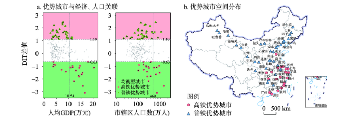
图5
铁路城市位势差值与社会经济发展关系
Fig. 5
Relationship between the difference of rail-city centrality and socio-economic development
3.3 运输联系空间层级
3.3.1 整体网络:“轴—辐”模式与廊道结构
高铁与普铁运输联系呈现出差异化组织模式(图6)。高铁网络在遵循“链式运输”廊道效应的同时,也体现出跨区域尺度的“轴—辐”组织模式,尤以东部沿海城市群最为明显;在保障基本出行机会和公共服务均等化驱动下,基于普铁的功效空间呈现出大尺度廊道格局,更多揭示的是覆盖全国尺度的功效空间级联系统结构特征,这与前述普铁直接关联城市数多于高铁是一致的。具体来看,高铁网络集中在“胡焕庸线”以东,覆盖全国3/4的城市,特别是第一、二等级联系均集中分布于中东部地区,在空间上形成了与“四纵四横”客运专线基本一致的格局。普铁网络覆盖全国4/5以上的城市,涉及城际联系对数量约比高铁多一半(50.79%)。经过长期的铁路建设,普铁网络围绕京广—京哈、陇海—兰新、京九、沪昆等铁路干线,基本形成了具有“普适”特征的全国大区域联系框架。
图6
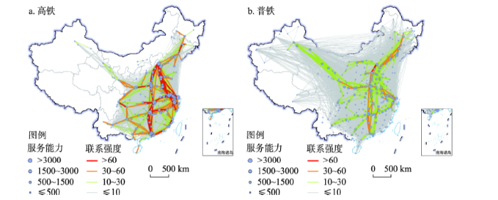
图6
2019年基于高铁与普铁的功效空间级联系统
Fig. 6
Spatial cascading system of high-speed rail and conventional rail networks in 2019
3.3.2 重叠网络②(②重叠网络由高铁和普铁同时运营的城市对组成。):“钻石形”区域内出行与中长距离的跨区域出行
重叠网络沿“四纵四横”客运通道展开,涉及199个城市和7539条城际联系,平均运输距离为728 km(图7)。高铁在3164条(41.97%)客运联系中具有优势,平均距离为586 km,主要承担以京津冀、长三角、珠三角、成渝地区为顶点的“钻石形”区域内部城市群及其间的出行联系,特别是前两个等级的高铁优势线路集中在“钻石形”范围内的城市群内以及四大城市群之间,主要服务于京津冀、长三角、珠三角等城市群内部高频跨城出行以及城市群间联系。普铁网络密度较低的东南客运密集走廊也是高铁优势线路集中地区。普铁在2680条(35.55%)客运联系中具有优势,平均运距为789 km,在空间上主要集中在传统客运主通道,包括两类,一类是距离长,高铁比较优势不突出的线路,集中在西北兰新沿线。究其原因,与两类方式的技术运营特征直接相关,高铁夜间检修停运使得普铁的平均运距超过高铁。经济性考虑和普铁卧铺过夜增加出行舒适度等因素的存在,使得普铁在远距离出行中具有一定的竞争优势。另一类是人流密度大的城市对,沿线高铁与既有铁路通道(京哈、京九、武广以及浙赣等)并行,高客运需求使得普铁仍具有相对优势。此外,高铁和普铁在经济发达地区共存表明了由于二者差异化技术经济特征,普铁仍具有较大的需求。
图7
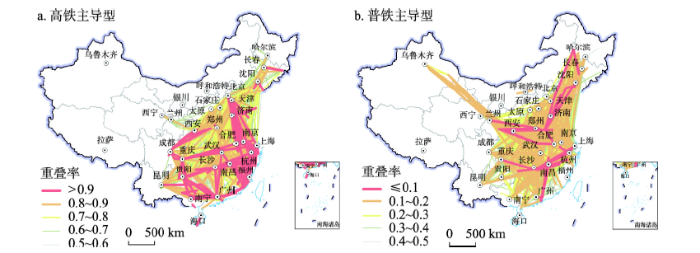
图7
2019年中国高铁与普铁叠合网络空间布局
Fig. 7
Spatial pattern of totally overlapped network by high-speed rail and conventional rail in 2019
4 功效空间组织的区域整合效应:高铁与普铁
铁路运营通过提升可达性和要素流通效率引导区域整合。基于社团内部联系紧密、社团间联系较弱的基本属性,本文通过对高铁和普铁网络进行社团划分以揭示全国和区域层面高铁与普铁对功效空间组织的区域整合作用。
高铁和普铁基于各自的网络干线布局分别形成了14个和12个社团,呈现出差异化的地理空间依赖性和空间形态(图8)。相较于普铁,高铁距离衰减效应更为显著,因而其社团划分结果呈现出显著的邻近区域集聚特征,特别是在长江以南地区,形成以广州为核心,覆盖广东北部和西部、湖南大部、广西、贵州和云南的华南社团;以杭州、福州、南昌为核心,覆盖浙江、福建和江西的东南社团;以重庆为核心,覆盖成渝以及湖北西南部的西南社团。长江以北区域形成了4个显著的跨区域廊道社团,包括京沪高铁沿线组成的京沪社团、京广高铁(石家庄—武汉段)组成的石武社团;以京哈高铁沿线组成的东北社团以及西兰、兰新高铁沿线组成的西北社团等。在高铁的竞争下,普铁客运市场集中在中长途,所形成的社团均呈现出沿主要铁路干线的大尺度南北向和东西向跨区域廊道集聚特征,如社团6主要由京九铁路沿线城市组成、社团1主要由京广线以及部分东西向沿江铁路(武汉—重庆段)、广昆铁路(广州—南宁段)沿线城市组成、还包括浙赣—湘黔沿线城市组成的社团3以及西北兰新通道沿线城市组成的社团5等。上述社团划分结果从整体上反映了高铁与普铁的区域整合的基本格局特征,接下来本文进一步从全国和区域层面揭示基于运营组织的两类网络的区域整合模式。
图8
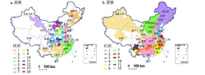
图8
中国高铁与普铁网络社团划分格局
Fig. 8
Spatial pattern of communities by high-speed rail and conventional rail networks in China
4.1 全国尺度
为揭示全国层面高铁与普铁区域整合模式,本文将各社团作为节点,将不同社团所属城市之间的联系统合为社团间联系,并据此生成拓扑网络结构图(图9)。高铁功效空间区域整合呈现出显著的两极分化态势,形成了以京沪(社团1)、华南(社团2)、东南(社团3)以及石武(社团4)等强高铁服务能力社团为核心的多中心等级化组织模式,四大核心社团间亦具有高强度的高铁联系。成渝(社团6)、东北(社团5)和西北(社团7)三大区域性社团高铁服务能力并不突出,远低于四大核心组团,与剩余分散社团共同成形成第二梯队。同时,第二梯队也主要与四大核心社团进行联系。需要指出的是,成渝社团并未出现在高铁功效空间体系的核心社团系列,且与四大核心社团联系不强,这在一定程度上表明了基于服务能力的高铁功效空间组织与“钻石型”国土空间以及“四极六轴”国家立体综合交通网布局并不完全一致,仍需重点完善[37]。与高铁相比,普铁功效空间区域整合呈现出了多板块均衡化组织模式,除一些零散社团外,主要板块按铁路服务能力从高到底依次为京广(社团1)、京沪南段(社团4)、沪昆(社团3)、京九(社团6)、东北(社团2)和西北(社团5),社团服务能力以及社团间的联系强度都较为均衡,这明晰了前述全国层面上基于普铁的功效空间组织的普惠导向。
图9
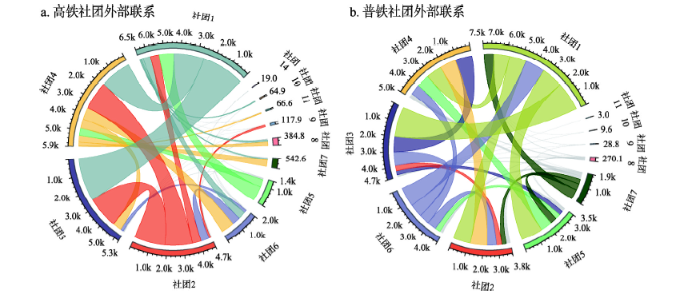
图9
基于高铁与普铁的功效空间级联系统网络拓扑结构
Fig. 9
Network topology of spatial cascading system by high-speed rail and conventional rail
中国西高东低、复杂多样的自然地理结构、自然资源分布的空间不均衡性、及此基础上形成的社会经济布局等从供需层面决定了中国铁路客货运输的基本格局。相较于普铁,高铁集中在中东部城镇密集地区,距离衰减效应显著,再加上票价较高,更多地成为以追求时间价值、舒适性与准时性为主要考量的群体出行选择[26]。在空间上重点连通人口密度高、经济发达的城市群地区、省会城市和其他大中城市。与航空与公路相比,高铁在200~700 km运输距离范围内具有优势[27]。因此,全国层面上,基于高铁的运输联系主要揭示效率为导向的功效空间组织模式。与此对应的是,普铁由于低票价、覆盖范围广,成为以追求经济性为主要考虑群体的出行工具选择,其空间范围呈现“普适性”特征。同时,普铁可以夜间行驶、出售卧铺票等因素使得其在远距离出行方面具有可能性。与高铁相比,基于普铁的客运联系更多反映的是以多板块均衡化导向的功效空间组织模式。
4.2 区域尺度
根据社团划分结果,本文分别选取高铁网络的京沪社团和普铁网络的京广社团以揭示区域层面上两类网络的区域整合模式。上述两社团运营服务能力最强、铁路网络布局较为成熟,是两类网络中发育较为成熟的社团。京沪社团主要基于京沪高铁、济青高铁以及社团内京津冀、山东半岛以及长三角区域城际铁路形成,整体发育程度较高。京沪高铁、济青高铁将三大区域沿途北京、天津、济南、徐州、南京、上海等核心城市贯穿,促进了沿途城市之间的交流与融合,中心城市之间交流融合的不断增加也带来了沿线中小城市的发展,从而为形成高铁“走廊型”区域整合奠定基础。另一方面,高铁网络的进一步扩张与“公交化”方式运营的城际铁路承担了区域内部中小城市以及中小城市与核心城市之间的跨城出行,进一步促进了城市群内部融合,形成“区域化”整合模式。因此,高铁的这种轴—辐运营模式支撑了三大区域的跨区融合发展,形成了高铁“廊道+区域(城市群)”整合模式(图10a、10b)。就普铁京广社团来说,该社团主要以京广普铁为主通道构成了贯穿南北的跨区域社团。在高铁的竞争下,普铁更加集中于中长途市场,站点设置差异小且停站较多,形成了大尺度跨区域廊道整合模式(图10c、10d)。同时,由于东西向沿江铁路(武汉—重庆段)、广昆铁路(广州—南宁段)、包海铁路(南宁—海口段)的存在形成的普铁网络化,局部地区延伸出东西向“廊道”。
图10
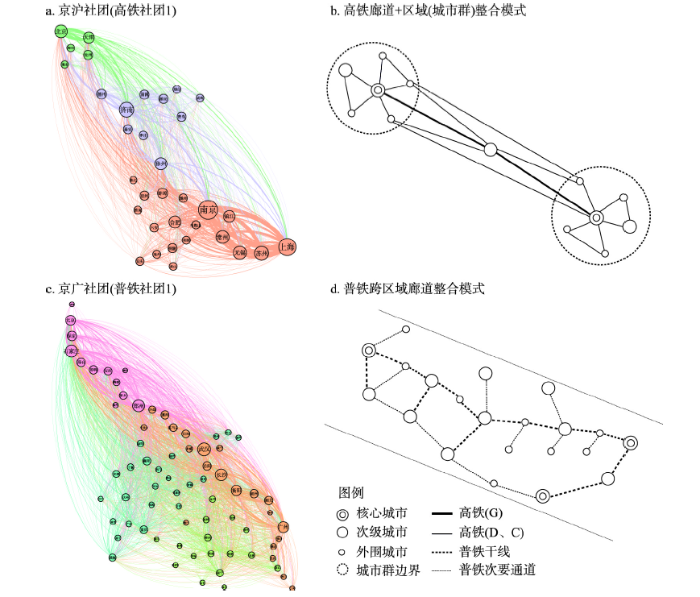
图10
基于高铁与普铁的区域整合模式示意图
Fig. 10
Regional integration model based on high speed rail and conventional rail
5 结论与讨论
在高铁网络架构基本形成,追求与普铁平衡发展背景下,本文比较分析了基于高铁与普铁的功效空间级联系统结构,揭示了二者对经济社会空间组织的整合效应,主要结论为:
高铁与普铁形成了差异化空间运输联系结构,刻画了差异化空间级联系统特征。相较于普铁,高铁布局与全国经济社会发展梯度格局更一致,但普铁服务均衡性更强。高铁客流联系距离衰减效应更明显,在600 km范围内最具优势;高铁和普铁城市位势分别呈“金字塔”型和“纺锤”型分布结构,且两者的优势城市呈显著的南北分异。高铁和普铁网络社团等级结构呈现出差异化的地理空间依赖性和形态,高铁社团形成了14个以邻近区域集聚为主要形态的功能性社团,普铁形成了12个沿主要铁路干线的大尺度南北向和东西向跨区域廊道集聚形态的功能性社团。
高铁和普铁的区域整合模式表现不一。在全国层面上,高铁功效空间区域整合呈现出显著的两极分化态势,形成了以京沪、石武、华南以及东南等强高铁服务能力社团为核心的多中心等级化组织模式。基于服务能力的高铁功效空间组织与“钻石型”国土空间以及“四极六轴”国家立体综合交通网布局并不完全一致,仍需重点完善。普铁功效空间区域整合呈现出了多板块均衡化组织模式。在区域层面上,高铁的轴—辐运营模式支撑高铁形成了“廊道+区域(城市群)”整合模式。普铁在高铁的竞争下主要集中于中长途市场,形成了大尺度跨区域廊道整合模式。需要指出的是,普铁在经济发达地区仍然有巨大的市场空间,依然需要重视普铁发展,满足经济发达地区差异化群体出行需求。
相较于以往单一铁路或高铁的研究,本文所得到的铁路运输联系格局与空间尺度存在一定的共性。本文创新之处在于关注铁路运输内部的不同运输方式—高铁与普铁在支撑空间级联系统中的耦合性与差异性,揭示了高铁与普铁对功效空间结构重塑的差异化特征与组织模式,丰富与深化了现有多元交通流特别是铁路交通流的研究。在后续研究中,可结合长时间数据探讨高铁与普铁功效空间结构体系的演化模式。此外,铁路时刻表数据仅能反映供给侧的现状,还需要结合需求侧客流数据做进一步的探讨。
参考文献
Spillovers and the locational effects of public infrastructure
DOI:10.1111/jors.1998.38.issue-3 URL [本文引用: 1]
The basic theory and life-circle pattern of traffic economic belt's development and evolvement
交通经济带的基础理论及其生命周期模式研究
Spatial analysis of the impact of transport accessibility on regional performance: A study for Europe
Railway network expansion and spatial accessibility analysis in China: 1906-2000
20世纪中国铁路网扩展及其空间通达性
Impacts of high speed rail on railroad network accessibility in China
DOI:10.1016/j.jtrangeo.2014.03.010 URL [本文引用: 1]
The influence of Beijing-Shanghai high-speed railways on land accessibility of regional center cities
DOI:10.11821/xb201010013
[本文引用: 1]

Since some limitations existed in the current accessibility method, integrated method of network analysis and cost weighted raster analysis were designed and applied to generate city isochronous rings after the operation of high-speed railways. The valuation of accessibility was conducted with three indicators, i.e. daily accessibility, potential model, and weighted average time. After the valuation, differences between accessibility patterns with scenarios with and without high-speed railways were analyzed, and influences of the high-speed railways on center cities' accessibility were discussed. Changes in hinterlands of the center cities were also calculated with field intensity model. The results indicated that high-speed railways would expand the isochronous rings, and realize significant optimization of urban daily accessibility and form uneven time convergence space. Sites along the high-speed railways became the biggest beneficiaries of time convergence, as the variability of their weighted average time and potential values were high. In different geographical scales, the high-speed railways reduced the equilibrium of weighted average time, and their influences on the equilibrium of potential values are inconsistent. The high-speed railways would expand the hinterlands of Beijing and Shanghai, and strengthen their regional influences. As accessibility changes differed in different regions, the industrial structure should be adjusted in regions with high accessibility variability, while regions with low accessibility variability should improve rapid transit networks, and increase accessibility by strengthening their links with high-speed railways.
京沪高铁对区域中心城市陆路可达性影响
DOI:10.11821/xb201010013
[本文引用: 1]
针对目前可达性研究技术的局限,设计网络分析与成本栅格加权集成法,并应用该方法生成高铁通车后城市等时圈图。利用日常可达性、潜力值与加权平均时间,比较有无京沪高铁两种情景下京沪地区中心城市可达性空间格局变化,探讨高铁对中心城市可达性的影响,并采用场强模型计算高铁通车前后中心城市腹地范围。结果显示:高铁将扩展等时圈范围,实现城市日常可达性整体大幅优化,形成非均衡的时间收敛空间。高铁站点沿线成为时间收敛的最大受益者,它们的加权平均时间与潜力值变率高。在不同地理尺度下,高铁降低加权平均时间均衡性,对潜力值均衡性影响不一致。高铁扩大北京与上海的腹地,增强其区域辐射力。针对区域可达性变化,可达性变率高的城市可适时调整产业类型,变率低的城市可通过加强快速交通网络与高铁的衔接来提高可达性。
Technological relatedness, regional accessibility and firm productivity
DOI:10.11821/dlyj020201280
[本文引用: 1]
Firm productivity is the basis to maintain regional sustainable development. Recent studies positively link the role of technological relatedness to various economic indicators, including firm survival, firm innovation and firm productivity. The co-agglomeration of diverse industries facilitates inter-industry spillovers and firms are more likely to benefit from inter-industry spillovers given the industries engage in similar types of economic activities. It leads to the recombination of new ideas and eventually promotes firm performance. While technological relatedness has been linked to promoting economic growth and development, it is unlikely that all firms will benefit equally from technologically related spillovers. Firms with better regional accessibility have higher incentives to seek out and rely on un-local resources, which in turn, affect the relations between technological relatedness and firm economic productivity. Based on China's Annual Survey of Industrial Firms (ASIF), this article employs a two-stage least squares (2SLS) method to investigate the effects of technological relatedness on firm productivity, which varies for different kinds of regional accessibility. The results show that: (1) Technological relatedness plays an important role in increasing firm productivity. Firms are more likely to benefit from inter-industry spillovers given the industries engage in similar types of economic activities. (2) The effects of technological relatedness on firm productivity have been shown to depend, in part, on the regional accessibilities. The growth of the firms with better road accessibility will be more dependent on technological relatedness, while the increase of regional railway accessibility may weaken the influences of technological relatedness. (3) There is industrial and spatial heterogeneity in the moderating effect of regional accessibility. Compared with labour-intensive firms, the relations between technological relatedness and the capital-intensive and technology-intensive firm productivity can be more significantly affected by regional accessibility. Besides, the improvement of road accessibility makes firms in the eastern region more path-dependent, and firms in the western region more path-breaking. Nevertheless, regional railway accessibility has no significant impact on firms in the central and western regions. The findings indicate that both technological relatedness and regional accessibility play a substantial role in improving the firm productivity in transitional economies.
技术关联、交通可达性与企业生产率: 基于公路和铁路的研究
DOI:10.11821/dlyj020201280
[本文引用: 1]
企业是区域经济发展的微观基础。企业生产率增长会影响区域长期经济发展,因此有必要深入分析企业生产率变动的影响因素和内在机制。基于中国工业企业年度调查数据(ASIF),通过两阶段回归模型(2SLS)探讨企业与区域产业环境间的技术关联对企业生产率的影响,并分析不同交通类型的区域可达性的调节作用差异。结果显示:① 企业与区域间的技术关联越高,企业的全要素生产率会越高。② 区域可达性能够调节技术关联与企业生产率间的关系,且异质性交通网络的调节效应不同。在公路可达性高的区域内,企业生产率受到企业与区域间技术关联的影响较强;相反,提升区域铁路可达性则主要表现为削弱技术关联对企业生产率的作用。③ 区域可达性的调节效应还存在产业和空间异质性。比起劳动密集型企业,资本、技术密集型企业的生产率与技术关联间的关系受区域可达性的影响更明显。对于不同区域,公路可达性会使东部企业的生产率更依赖技术关联,而中西部企业刚好相反;铁路可达性则能促使东部企业发生“突破性”的生产率变化,对中西部企业没有明显影响。
Impact of high-speed rail on regional economic disparity in China
DOI:10.1016/j.jtrangeo.2017.08.003 URL [本文引用: 1]
How does city-cluster high-speed rail facilitate regional integration? Evidence from the Shanghai-Nanjing corridor
DOI:10.1016/j.cities.2018.12.003 URL [本文引用: 3]
Theory and methodology of transportation development and location measures
DOI:10.11821/dlxb201804006
[本文引用: 1]
Variations of locational conditions caused by transport infrastructure construction largely promoted the agglomeration of production factors and the local economy and reshaped the regional structure. Hence, measuring transport location has become one of the fundamental topics in geography. Recently, along with transport development, as well as the emergence of new technology, new models, new factors and new industrial forms, the locational conditions have been reconstructed and individual travel concept and patterns changed. The existing research on measuring transport location considers not only the location in the geographic context in terms of the spatial location and transport infrastructure network but also the location in the flow of space concerning the network connectivity, reliability and travel convenience. The research objects changed from various locations to the micro-location regarding group travel characteristics and differences at the individual level. The research contents included door-to-door trips in the accessibility of transport networks. Meanwhile, techniques of big data and GIS-T methods make measuring transport location more accurate.
交通发展区位测度的理论与方法
DOI:10.11821/dlxb201804006
[本文引用: 1]
交通建设所引致的区位条件改善对促进各类生产要素集聚和地方经济发展,重塑区域空间结构具有重要作用,因此,交通区位的测度一直是地理学的核心议题之一。随着交通网络的不断发展与完善以及新技术、新模式、新因素和新业态的出现,地方传统区位条件被重构,个人出行理念和模式发生了一系列变化。① 交通区位的测度逐渐从依托空间位置和交通设施发展水平的传统地理区位扩展到依托网络连通性、可靠性与出行便捷性的“流空间”新区位;② 研究对象从关注不同地方的区位特征扩展到关注群体出行规律和个体行为差异的微观区位选择;③ 研究内容从交通设施网络的可达性扩展到基于“门到门”的全链条出行服务;④ 大数据挖掘技术和GIS-T技术的发展也使得交通区位的测度朝着更加精确化和精准化的方向迈进。
高速铁路对城市网络结构的影响研究: 基于铁路客运班列分析
DOI:10.11821/dlxb201602007
[本文引用: 1]
城市网络是近年来城市与区域研究的一个新方向.基于2003-2013年间8个横截面的中国铁路客运班列数据,采用加权度中心性和社区结构模型,探讨高速铁路建设对城市等级和集聚性空间格局及演化的影响.研究表明:① 基于铁路客运组织的城市等级结构呈现出位序--规模分布的特征和集聚性,且三大地带和各社区内城市也呈现出明显的位序--规模分布,随着高速铁路网络的扩展,加权度中心性的集聚性更明显,并逐步呈现出较为明显的层级结构和社区结构.② 城市等级结构呈现出明显的东中西地带性,廊道效应和经济,人口的耦合性,即基于铁路客运班列的城市等级结构与基于属性数据(人口/GDP)的结果表现出较大的相似性,但也存在一定的差异.城市社区结构与中国高速铁路网络,城市群的空间分布格局基本一致.随着高速铁路的建设,东中西三大地带间城市等级的差异呈扩大态势,但各社区间城市等级的差异呈缩小态势,部分社区核心城市已形成.
Spatial interaction and network structure evolvement of cities in term of China's railway passenger flow in 1990s
DOI:10.11820/dlkxjz.2005.02.009
[本文引用: 1]
Cities seperated in space are connected together by spatial interactions (SI) between them. But the studies focusing on the SI are relatively few in China mainly because of the scarity of data. This paper deals with the SI in terms of rail passenger flows in 1990s, which is an important aspect of the network structure of urban agglomerations. By using a data set consisting of 1991 and 2000 rail O-D passenger flows between nearly 200 cities, intercity rail distance O-D matrixes, and some other indices. It is found that the attenuating tendency of rail passenger is obvious, but the gravity model cannot explain the change over time. Then a further study is carried out based on the hub-and-spoke framework under which the error of gravity model is explained. And by analysis of dominant flows and spatial structure of flows, we find that passenger flows have a trend of polarizing to hubs while the links between hubs upgrades, and some driven factors for the re-organization process of the structure of urban agglomerations are discussed.
空间相互作用与城市关联网络演进: 以我国20世纪90年代城际铁路客流为例
Spatio-temporal evolution of land transportation connection in the Yangtze River Delta urban agglomeration under the background of area expansion
空间扩容背景下长三角城市群陆路交通联系时空演化
High-speed rail network spatial structure and organization model in China
DOI:10.13249/j.cnki.sgs.2020.01.010
[本文引用: 1]
High-speed rail is an important part of modern transport infrastructure. It has an important impact on the flow of production factors, the expansion of urban space, and the reconstruction of regional spatial structure. Based on the O-D data of high-speed rail network in 2018, the social network analysis is used to discuss the structural characteristics of high-speed rail network and other organizational modes from HSR network and urban nodes. The results show that: 1) China's high-speed rail network has experienced four stages of germination, start-up, tortuous development and prosperity. China's high-speed rail network is relatively loose overall, the northeast region has the highest network density and western network density is sparse. High-speed rail links between the western region and the northeastern region are sparse. The intermediary role of the central and eastern regions in the overall network is obvious; 2) The “corridor effect” of the important high-speed rail channel is remarkable. The area along the Beijing-Shanghai high-speed railway and the Beijing-Guangzhou high-speed railway has become hot spot with high central value region. On the whole, it has a “triangular flag” composed of Beijing-Guangzhou, Beijing-Shanghai and Shanghai-Kunming high-speed railways. Spatial pattern and the trend of decreasing toward the cities on both sides. The centrality of the intermediary shows that the random distribution of the central hub city can better play a cohesive role; 3) The first-level high-speed rail network shows the high-speed rail corridors closely related to Shanghai-Nanjing Intercity, Beijing-Tianjin Intercity and Wuhan-Guangzhou High-speed Railway. The second-level network basically reveals the road network planning of China's high-speed railways and the provincial cities in the high-speed rail network as a prominent intermediary role; The third level identifies the trend of the high-speed rail network from four horizontal and vertical expand to eight horizontal and eight vertical. The fourth level of China's high-speed rail network shows overall spatial network details; 4) The territorial organization models of high-speed railway network is characterized by point-axis beading mode, dual-core grouping mode and polar core model, the perfection of the high-speed railway networkhas transformed the organizational model from a single core to a network.
中国高铁网络结构特征及其组织模式
DOI:10.13249/j.cnki.sgs.2020.01.010
[本文引用: 1]
基于2018年高铁网络OD数据,运用社会网络分析方法从高铁网络、城市节点等方面探讨中国城市高铁网络结构特征及其地域组织模式,结果表明:①中国高铁网络整体较为松散,东北地区网络密度最高,东部和中部地区作为整体网络的中介作用明显;②重要高铁线路的“廊道效应”突出,中心度呈现出以京广、京沪和沪昆高铁组成的“三角旗状”空间格局并向两侧城市呈不规则递减的态势;③多层级网络识别出紧密关联高铁线路和四横四纵向八横八纵格局的转变;④高铁网络的地域组织形式表现为点-轴串珠模式、双核组团模式和极核模式,高铁网络的完善使组织模式由单核趋向于网络化转变。
Network pattern and spatial characteristics of railway passenger flow in China
中国铁路客运流的网络格局与空间特征研究
Spatial pattern of urban centrality on railway hub in China's mainland
基于铁路网的中国主要城市中心性的空间格局
Comparison of spatial structure and organization mode of inter-city networks from the perspective of railway and air passenger flow
DOI:10.11821/dlxb201708013
[本文引用: 2]
As traffic flow reflects the socio-economic relations between cities, it is widely applied as a key factor in studies on city networks. Based on the inter-city railway and air passenger flow in 2010, this article made a comparison of the spatial structure and passenger flow organization of inter-city networks from the perspective of railway and air passenger flow, in terms of node, linkage, and community. The results are as follows: (1) Both city networks based on railway and air passenger flow present a hierarchical structure with Beijing, Shanghai and Guangzhou being the top three, while the nodes in the lower classes of two networks are different. (2) The spatial structure of linkages between cities based on railway passenger flow displays strong neighborhood effect. In contrast, the cities' own characteristics play a dominant role in the organization of air passenger flow. (3) Most of the dominant railway passenger flow is directed to the capital city in each province, forming several disperse regional systems separated by the provincial boundaries. In terms of air passenger flow, the regional systems are integrated by vertical linkages between them. (4) Although the community structure is not obvious from the perspective of air passenger flow, there are seven communities of significant geographical characteristics being detected in the railway network. The main differences between two networks are attributed to the management systems and technical characteristics of the modes of transportation.
中国城市网络等级结构特征及组织模式: 基于铁路和航空流的比较
DOI:10.11821/dlxb201708013
[本文引用: 2]
交通流是反映城市间社会经济联系的重要表征,被广泛应用于城市网络研究中。基于2010年中国城际铁路与航空客流OD数据,本文从城市节点、流量、子网络视角对中国城市网络的结构特征与组织模式进行了比较研究,发现:① 铁路与航空流视角下的中国城市网络均呈现出以北上广为顶层节点的空间等级结构体系,但除顶层结构外两种网络结构差异较大。② 城市网络体系中的铁路流联系表现出空间邻近性特征,而航空流联系则主要受到城市节点的规模大小与职能属性的影响。③ 铁路流的首位联系受省级行政区划的制约,航空流的首位联系空间跨度大,形成了若干具有垂直层间联系的地域子系统。④ 铁路网络拥有具有显著地域特征的7个子网络,而航空网络中则不存在明显的子网络。技术经济特征与管理体制是造成铁路与航空两种网络特征差异的主要原因。
Evolution and geographic effects of high-speed rail in East Asia
DOI:10.11821/dlxb201604004
[本文引用: 2]
East Asia plays an increasingly important role in the world economy in a line with the development of economic integration and accelerated globalization. As one of the influencing factors of economic integration and regional development, HSR will largely influence the regional development, regional structure, commuting, and regional integration. In this paper, we take the high-speed rail in East Asia as a case to explore the evolution of HSR and its impacts on transport circle and accessibility of cities. Results indicate that the evolution of HSR in East Asia firstly follows the "core cities - core cities" mode and then forms a whole network spatially; HSR network has higher service market in population and GDP than in landuse, and the service markets of HSR network in 2012 are mainly located in the eastern and central regions of China, Japan and South Korea, and those of planned HSR network expand to western China and Japan, south part of South Korea; the 1-h transport circle of core cities in East Asia presents a continuous trend along trunk HSR lines, and the 2-h transport circle has formed continuous egions in the Yangtze River Delta, Pearl River Delta, Tokyo, Seoul or along trunk HSR lines, while the court of weighted shortest travel time of cities in China's mainland,Japan and South Korea presents the "core- peripheral structure", taking Zhengzhou in Henan province, Tokyo and Seoul as the core cities; as the development of HSR, the cities located along the trunk HSR lines have a large increase in accessibility, which shows the "corridor effects".
东亚高速铁路网络的发展演化与地理效应评价
DOI:10.11821/dlxb201604004
[本文引用: 2]
经济全球化和区域一体化进程的不断推进,促使东亚在世界经济中的地位不断提升。高速铁路作为促进经济一体化和区域发展的重要手段和基础,其快速发展势必会对东亚地区的区域发展、空间结构、人口流动和一体化产生重大影响。在分析东亚高速铁路网络发展历程及服务水平的基础上,评价与对比了高速铁路建设对城市交通圈和可达性的影响,及一体化高速铁路潜在的空间效应,以期为东亚一体化高速铁路构建提供指导。结果表明:东亚高速铁路网络扩张整体上呈现出“核心—核心”到网络化的发展历程;高速铁路网络在中国东中部、日本和韩国等地区具有较高的人口和产业服务水平,但国土面积覆盖率相对较低;高速铁路的建设促使核心城市交通圈格局不断扩展与强化,可实现当日往返城市对数量明显增加,主要分布在中国长三角、珠三角,日本东京和韩国首尔周边;中国大陆、日本和韩国的加权平均旅行时间分别呈现出以郑州、东京和首尔为中心的“核心—边缘”结构,且圈层结构逐渐向高速铁路沿线延伸;高速铁路的建设促使城市人口服务水平和可达性的空间格局均呈现出明显的“廊道效应”。
The evolution of regional spatial structure influenced by passenger rail service: A case study of the Yangtze River Delta
DOI:10.1111/grow.v53.2 URL [本文引用: 3]
The intercity railway connections in China: A comparative analysis of high-speed train and conventional train services
DOI:10.1016/j.tranpol.2022.02.007 URL [本文引用: 4]
A review of corridor and transport corridor
20世纪走廊及交通运输走廊研究进展
Impact of high-speed rail on the operational capacity of conventional rail in China
DOI:10.1016/j.tranpol.2021.06.016 URL [本文引用: 1]
China's bullet trains facilitate market integration and mitigate the cost of megacity growth
Scale economies, product differentiation, and the pattern of trade
Research on travel mode share and operation strategy in Baoji-Lanzhou transportation corridor
DOI:10.12733/issn.1548-7741 URL [本文引用: 4]
Comparison of spatial structure and linkage systems and geographic constraints: A perspective of multiple traffic flows
DOI:10.11821/dlxb201912005
[本文引用: 3]
Transportation connection has always been one of the important perspectives of studying spatial cascading systems and urban systems. Based on the timetable data in 2018 of inter-city coach, high-speed train and aviation, this paper builds networks of the three modes of transportation in China. Through the methods of the city-pair connectivity and community detection, this paper compares the spatial structure and linkage systems of multi-traffic flow network and reveals the geospatial constraints. The research results show that: (1) Different modes of transportation are suitable for portraying urban systems on different spatial and administrative scales. Inter-city coaches are constrained by the provincial administrative boundaries. High-speed train network shows the effect of corridors especially along the main trunks. The aviation network reflects the spatial relationship at the national scale. (2) From the perspective of the direct accessibility, there is a large spatial overlap between inter-city coaches and high-speed trains, and the market of inter-city coaches is obviously squeezed in recent years. For air transport, its frequency advantage mainly concentrates on the city-pairs with a long distance. The competition and complementarity of the three modes of transportation have a great impact on the urban system and are useful for the understanding of the spatial cascading system. (3) Geographical space, infrastructure space and administrative space constraint and management system are important factors affecting the transportation networks. Inter-city coach network and high-speed train network are obviously affected by distance attenuation effects, and they present significant community structures in the two networks, but their communities have different spatial characteristics. However, air transport does not follow the constraint of distance attenuation, and there is not an obvious community structure in the network. Factors related to the passenger transport market, such as social and economic links and tourism resources, play the important roles in the aviation network structure.
多元交通流视角下的空间级联系统比较与地理空间约束
DOI:10.11821/dlxb201912005
[本文引用: 3]
交通运输联系是区域空间级联系统与城市体系结构研究的重要视角之一,而不同交通运输方式表达的级联体系结构亦存在一定的差异。为综合研究交通运输体系刻画的空间级联系统及克服单一交通方式的局限性,基于长途汽车、高铁和航班时刻表数据,比较分析了多元交通网络的空间级联体系结构及其表达的城市网络组织体系,并进一步揭示了地理空间的约束作用。研究发现:① 每种交通运输方式适合在一定的空间尺度和行政范围内刻画和表达城市网络体系结构与城市联系,公路客运受省域行政范围约束,高铁联系具有廊道影响效应,航空运输体现全国和区域尺度较高层次的社会经济联系。② 从旅客直达视角分析,长途汽车与高铁的城际运输市场重叠最大,近年来长途汽车的运输市场受高铁影响明显。③ 地理空间是影响陆路交通运输和组织的重要约束因子,距离衰减效应明显;结合设施空间、行政空间和管理体制的作用,长途汽车和高铁运输在空间上形成分异的社区结构;航空运输由于具有超空间连接特性,既不遵循距离衰减规律,社区结构也并不明显。
Socioeconomic impact assessments of high-Speed rail: A meta-Analysis
DOI:10.1080/01441647.2021.1979689 URL [本文引用: 1]
On borrowed size, flawed urbanisation and emerging enclave spaces: The exceptional urbanism of Luxembourg
DOI:10.1177/0969776414528723
URL
[本文引用: 1]
This paper investigates the development trajectory and spatial governance practices in the Grand Duchy of Luxembourg, a small but affluent, rapidly developing member state of the European Union. Against the background of globalisation and its urban impact (particularly concerning smaller or emerging metropolitan areas), the paper aims at reconstructing the Luxembourgian urban development trajectory, which is characterised by continuous population growth and successful attraction of global services and financial industries in a rather unique context of the niche sovereignty politics of the small state/small city. The paper also presents a carefully balanced critique of governance practices that seeks to implement integrative strategies in a rather fragmented setting of development, policy and regulation. In so doing, the paper situates this specific case of urbanisation in the context of current paths and narratives of development, particularly with respect to the emergence of global ‘enclave spaces’ and the way these are becoming nested into broader network constellations. The paper also discusses possible consequences for both governance practices and comparative urban studies.
Is high speed rail an appropriate solution to China's rail capacity problems?
DOI:10.1016/j.jtrangeo.2014.05.004 URL [本文引用: 1]
Should China further expand its high-speed rail network? Consider the low-cost carrier factor
DOI:10.1016/j.tra.2017.04.010 URL [本文引用: 1]
Comparing passenger flow and time schedule data to analyse high-speed railways and urban networks in China
DOI:10.1177/0042098018761498
URL
[本文引用: 1]
China’s High-Speed Railways (HSR) network is the biggest in the world, transporting large numbers of passengers by high-speed trains through urban networks. Little is known about the analytical meaning of the use of two types of flow data, namely, time schedule (transportation mode flow) and passenger flow data, to characterise the configuration of urban networks regarding the potential spatial effects of HSR networks on urban networks. In this article, we compare HSR passenger flow data with time schedule data from 2013 in China within the same analytical framework. The findings show great differences in the strength of cities and links generated using the two different types of flow data. These differences can be explained largely by the socio-economic attributes of the cities involved, such as tertiary employment, GDP per capita, the cities’ topological properties (closeness centrality) in HSR networks and institutional factors (hub status), especially for the difference in link strength. The strength of first-tier cities in China with high socio-economic performance and the HSR links connecting core cites and major cities within respective regions tends to be underestimated when using time schedule flows compared with passenger flows. When analysing the spatial structure of HSR and urban networks by means of flows, it is important for urban geographers and transportation planners to consider the meaning of the different types of data with the analytical results.
Economic spatial structure in China: Evidence from railway transport network
This study analyzes the structure of China’s overall railway transport network and its sub-networks of conventional railway and high-speed railway, with the aim to understand the country’s economic spatial structure that is reflected by or underlines the railway transport network. First, the results indicate that compared with developed cities, backward cities not only have fewer train services but also lack a symmetrical transport plan; backward cities tend to connect with developed cities rather than within themselves. Second, the national-level urban hierarchy was established using the proposed algorithm, which helped reveal the economic geography of three economic plates in China. Third, the law of the primate city is not prominent in a large country such as China, which is undergoing regional restructuring with the economic center of gravity shifting to the coastal area while also moving south.
Maps of random walks on complex networks reveal community structure
DOI:10.1073/pnas.0706851105
PMID:18216267
[本文引用: 1]
To comprehend the multipartite organization of large-scale biological and social systems, we introduce an information theoretic approach that reveals community structure in weighted and directed networks. We use the probability flow of random walks on a network as a proxy for information flows in the real system and decompose the network into modules by compressing a description of the probability flow. The result is a map that both simplifies and highlights the regularities in the structure and their relationships. We illustrate the method by making a map of scientific communication as captured in the citation patterns of >6,000 journals. We discover a multicentric organization with fields that vary dramatically in size and degree of integration into the network of science. Along the backbone of the network-including physics, chemistry, molecular biology, and medicine-information flows bidirectionally, but the map reveals a directional pattern of citation from the applied fields to the basic sciences.
The spatial structures and organization patterns of China's city networks based on the highway passenger flows
DOI:10.11821/dlxb201702004
[本文引用: 1]
The multi-level perspective and multi-scalar city network have gradually become the critical pathways to understand spatial interactions and linkages. The road linkages represent distinguished characteristics of spatial dependence and distance decay, which is of great significance in depicting spatial relationships at regional scale. Based on the data of highway passenger flows between prefecture-level administrative units, this paper tries to identify the functional structures and regional impacts of China's city network, and further explores the spatial organization patterns of the existing functional regions, aiming to deepen the understanding of city network structure and provide new cognitive perspectives for the extant research. The empirical results are shown as follows: (1) It is immediately visible that the highway flows are extremely concentrated on the mega-regions of eastern coastal China and major economic zones in central and western China. And city networks based on highway flows demonstrate strong spatial dependence and hierarchical characteristics, which to a large extent has spatial coupling with the distributions of major mega-regions in China. It is a reflection of spatial relationships at regional scale and core-periphery structure. (2) A total of 19 communities that belong to important spatial configurations are identified through community detection algorithm, and we believe that they are urban economic regions within urban China. Their spatial metaphors can be concluded in three aspects. Firstly, many communities have the same boundaries with provincial level administrative units, which reveals that significant administrative region economy still exists in contemporary China. Secondly, trans-provincial linkages can be formed through spatial spillover effects of mega-regions within specific communities. Thirdly, cities located in the marginal areas of provinces and attracted by powerful center cities in neighboring provinces may become increasingly disconnected with their own provinces and be enrolled into communities of neighboring provinces, which make contribution to the formation of the trans-provincial core-periphery structures. (3) Each community, with its distinguished city network system, demonstrates strong spatial dependence and various spatial organization patterns. Regional patterns have emerged with the features of a multi-level, dynamic and networked system. (4) From the morphology perspective, the spatial pattern of regional city networks can be basically divided into monocentric structure, dual-nuclei structure, polycentric structure and low-level equilibration structure, with the monocentric structure as the major type.
基于公路客流的中国城市网络结构与空间组织模式
DOI:10.11821/dlxb201702004
[本文引用: 1]
多视角和多尺度城市网络逐渐成为认识空间关系的主要途径。公路流数据具有显著的空间依赖性和距离衰减特性,对于刻画区域尺度空间关系具有重要意义。基于全国地级行政单元间的公路客运流,论文尝试刻画中国城市网络功能结构和区域效应,并对其空间组织模式进行特征提取和规律挖掘,以期能够为城市网络研究提供新的方法支撑和认知视角。研究结果表明:① 基于公路流的城市网络空间形态表现出强烈的空间依赖性和层级特征,与中国主要城市群分布存在较大程度的空间耦合,更多体现的是区域尺度的空间关系及核心—外围组合关系;② 通过社区发现算法识别出19个城市经济区,其空间内涵主要包括行政区经济、巨型区域溢出效应和核心—边缘结构等;③ 不同地域系统内城市网络自成体系,表现出显著的空间依赖性和多元的空间组织模式,多层次、流动性和网络化的地域系统格局凸显;④ 从空间形态上看,区域城市网络空间结构大致可划分为单中心结构、双核心结构、多中心结构和低水平均势结构等区域关联形态,并以单中心发育模式为主。
Comparison of inter-city travel network during weekdays and holiday in China
DOI:10.11821/dlxb202004012
[本文引用: 1]
The differences of residents' travel purpose, travel time and regional attribute will lead to the heterogeneity of travel behavior. Working days and holidays have completely different time attributes, and the travel purpose is quite different. Therefore, comparing them has become an important way to reveal the inter-city travel network from different perspectives. Using migration data inferred from passenger travels during working days in April (11-15 April, 2016) and National Day golden week (1-7 October, 2016) from Tencent Location Big Data, this paper made a comparison of the spatial structure of inter-city travel network during weekdays and holiday in China. The results are as follows: (1) The average daily inter-city residents' travel scale during the golden week was significantly higher than that during the weekdays, but the travel distance and network clustering degree were significantly lower than the latter. (2) The two networks form three types of cross-regional group, adjacent group and provincial group. During the golden week, the number of cross-regional groups is significantly lower compared with weekdays, the number of regional and local hub cities is more than that of weekdays, and the number of adjacent groups and provincial groups is significantly higher than that of weekdays. (3) On weekdays, the three major cities of Beijing, Shanghai and Guangzhou have a prominent core position, and the function of tourism and transportation hub is highlighted in the golden week. (4) Weekday intercity network to cross-regional links, and the golden week is showing a clear spatial proximity effect, and formed a provincial capital as the center, the provincial travel core-peripheral mode. The structure and difference of inter-city travel network in the two periods are influenced by many factors, including geographical proximity, administrative division (proximity of cultural system), travel distance and travel purpose.
中国居民工作日与节假日的城际出行网络异同性研究
DOI:10.11821/dlxb202004012
[本文引用: 1]
居民出行目的、出行时间与地域属性的差异都会导致出行行为的异质性,工作日与节假日具有完全不同的时间属性,且出行目的差异较大,对两时段城际出行网络进行比较有助于全面认识城际出行规律及其网络特征。以4月份工作日(2016年4月11日—4月15日)和国庆黄金周(2016年10月1日—10月7日)为代表,利用“腾讯迁徙”提供的居民城际出行数据,从城市节点、城际关联及网络集聚角度对工作日与节假日的居民城际出行网络结构特征进行对比研究。结果发现:① 黄金周的日均城际居民出行规模显著高于工作日,但出行距离和网络集聚程度明显低于后者;② 两种网络均形成了跨区域组团、邻近组团和省域组团3种类型。黄金周跨区域组团数量明显低于工作日,区域和地方枢纽城市数量多于工作日,邻近组团和省域组团数量则明显高于工作日;③ 工作日,北上广三大城市核心地位突出,旅游功能、交通枢纽功能城市的地位在黄金周更得以凸显;④ 工作日城际出行网络以跨区域联系为主,而黄金周则呈现出明显的空间邻近效应,并形成了以省会为中心、省内出行为主的核心—外围模式。
Population-development oriented comprehensive modern transport system in China
DOI:10.11821/dlxb202012011
[本文引用: 1]
China's modernized transport strategies have been focused on building new infrastructures in areas with insufficient transport facilities, supplying the lack of new transport services, and investing in transport construction on a large scale since the 10th Five-Year Plan (2000-2005). However, these strategies are now facing new situations in population development, including population growth, migration, spatial relocation and agglomeration, and changes in lifestyle. It is imperative to investigate population-development oriented comprehensive modern transport system in order to implement people-oriented principles and the National Strategy of Strengthening Country in Transportation. This study presents some research results from the National Development and Reform Commission Key Research Project for the National 14th Five-Year Plan (2021-2025), "Population Development and Modern Transportation System Strategies in China". The study is based on theoretical mechanisms in the coupling and interaction between population and transport system. It conducts in-depth analyses on the new trends of population development and transport demand, and proposes a new "diamond" strategy for China's comprehensive transport system in order to cope with these new trends. According to this strategy, the new comprehensive modern transport system in China will have four "diamond pole" including Beijing-Tianjin-Hebei region, Yangtze River Delta, Guangdong-Hong Kong-Macao Greater Bay Area, and Chengdu-Chongqing region, four "diamond edges" including Beijing-Shanghai (Jing-Hu), Shanghai-Guangdong (Hu-Yue), Guangdong-Sichuan (Yue-Chuan), and Beijing-Sichuan (Jing-Chuan) transport corridors, two cross backbones including water transport along the Yangtze River and Beijing-Hong Kong-Macao transport corridors, and multiple transport hubs in cities with intensive intracity population movement flow. The study also proposes key missions to implement the new strategy in order to build population-development oriented comprehensive modern transport system in China, which includes supporting the national development and spatial plan, applying for the National Strategy of Strengthening Country in Transportation, and supplying high-quality transport services with a priority to the people.
适应人口发展的现代化综合交通运输体系研究
DOI:10.11821/dlxb202012011
[本文引用: 1]
自国家“十五”规划起,中国现代化综合交通运输体系构建以填空白、补短板、大规模设施建设为主,但近年来人口的增长、流动、空间集聚和生活方式等均发生了新的显著变化。以人为本,科学实施“交通强国”国家战略,亟待开展适应人口发展的现代化综合交通运输体系研究。本文基于国家发展与改革委员会国家“十四五”规划前期重大问题研究的部分成果,从人口与交通系统耦合协同机制出发,在深入分析人口发展及其交通需求趋势的基础上,提出适应人口发展的中国综合交通体系“钻石战略”。以京津冀、长三角、粤港澳、成渝城市群为“钻石”四极,以京沪通道、沪粤通道、粤川通道、京川通道为四边,以长江水陆通道、京港澳通道为十字骨架,以人口流入流出高强度的节点地区为枢纽,并提出构建适应人口发展的现代化综合交通运输体系实施重点,支撑国家重大空间发展战略;实施交通强国、适应人口发展;以人民为中心,打造高品质交通服务。
