

1 新时代背景特征
自18世纪晚期英国工业革命以来,人类活动对地球环境的影响达到空前程度。人类已逐步走出万年尺度的全新世,进入“人类世”这一特殊的新纪元——人类活动成为影响环境演化的重要力量[1]。近百年,人类不加节制地使用化石燃料,致使地球大气环境发生明显变化,由此引起的极端天气/气候事件和自然灾害的强度增大、频率加快,削弱了地球生态系统的服务功能,极大威胁着人类生存根基的稳定。严峻的自然灾害形势,使传统自然灾害研究面临巨大挑战,同时也给相关研究带来机遇。
(3)全球化治理与应对的需求牵引。在经济全球化背景下,高速的人流、物流、信息流使自然灾害的影响不再局限于当地,对周边国家乃至全球政治、经济和社会都会带来或大或小的冲击。例如,农业大国发生干旱或洪水导致粮食歉收,可能直接引发国际粮食市场价格波动;“卡特里娜”和“丽塔”飓风造成世界原油价格急剧上升,迫使布什政府不得不动用本国的石油战略储备;此外,跨国界的灾害还易引发灾民流散、疾病传播、社会动荡。自然灾害全球化治理与应对已成为新时代消除和解决非传统安全威胁的一项重要任务。
自然灾害作为人地系统相互作用的典型对象,其研究应抓住大数据、机器学习、全球化的时代机遇,推进信息地理学相关理论与方法的革新。这对提升自然灾害的全球应对水平和能力、乃至推进地理学变革性研究有重要意义。
2 新时代的自然灾害态势感知
所谓自然灾害态势感知是在特定时空下,对灾害系统动态环境中各种元素或对象的认知、理解以及对未来状态的预测。态势感知可分为两个层次:① 洞悉“态”:精准理解灾害的状态;主要包括灾害的识别与确认、毁损强度、灾害行为、造成当前状态的原因及方式等;例如,损害评估、行为分析、因果分析(包括溯源分析和取证分析)。② 预测“势”:精准预估灾害状态的发展趋势,主要包括态势演化、态势跟踪、影响评估、情境推演等(图1)。
图1
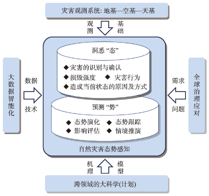
图1
新时代自然灾害态势感知的层次及范围
Fig. 1
Hierarchy and scope of natural disaster situational awareness in the new era
在传统灾害观测系统基础上,以大数据智能化为技术驱动、以大科学(计划)为学科基础、以全球大治理与应对为需求牵引,亟待发展实时、精准的自然灾害态势感知方法,实现从“观测”到“感知”的升级。
2.1 大数据智能化洞悉灾害的态
地基—空基—天基观测系统是度量自然灾害状态的传统手段。地基以地面观测站为主,具有准确性高等优势,但建站成本高,布点有限,难以进行大面积推广。空基是依托气球、飞机等载体进行观测,具有分辨率高、实时性强等优势,但受空域管制、极端天气条件、续航能力等限制,难以进行大面积观测。天基是以卫星为主的观测;虽可实现大面积观测,但易受云和植被覆盖的影响,空间分辨率相对较低、重访周期长。三者有机组合、优势互补构成了综合的自然灾害观测系统。地基—空基—天基能有效测量致灾因子、孕灾环境、承灾体“物”的状态,但对承灾体“人”的状态及其损失情况往往感知不足。为了弥补对承灾体“人”及相关损失的感知,通常会在灾后数周内由专业人员通过实地勘察、走访问讯等方式获得;但该方法耗时长、响应速度慢、成本高。
表1 传统灾害观测与大数据灾害感知
Tab. 1
| 传统灾害观测 | 大数据灾害感知 | |
|---|---|---|
| 目标 | 强调精准测量;强调对灾害现象进行观察或测定 | 强调感官认知;强调对灾害状态的理解 |
| 对象 | 灾害中损毁地物的面积、强度 | 灾损的严重程度;承灾体人的需求、情感、社会结构变化等,甚至包括灾区社会经济以及人地关系的感知 |
| 技术 | 专业人员通过地基—空基—天基设备进行量测 | 基于公众或非专业化设备提供的大数据,采用智能化技术进行推理 |
| 优势 | 多种观测手段,优势互补,科学性更强, 强调要素性 | 公众观测有效补充了对承灾体人以及对社会经济的感知,强调综合性 |
| 劣势 | 缺少对承灾体“人”的观测 | 数据的来源和科学性受限,需要对数据进行清洗和可靠性评价,需要与科学小数据进行融合 |
2.2 大科学(计划)预测灾害的势
目前,各领域虽已研发出各类自然灾害预测模型,但多数难满足应用的实际需求。其原因在于:受还原论影响,传统模型通常在其学科边界内、基于封闭系统的假设进行建模,难以直接应用于开放复杂地表环境下自然灾害态势的预测。
随着全球各大科学(计划)的推进,逐步形成系列跨自然科学、社会科学、人文科学和工程领域的合作平台和研究成果,为灾害态势的预测注入新活力。在上述成果基础上,应进一步打破领域知识壁垒、重塑知识结构,在协同创新中产生“整体大于部分之和”的效应,助力新时代自然灾害态势的预测,催生和促进更多能够满足实际需求的研究活动,并将科学知识真正转变为服务于区域或全球可持续发展的方案。
3 大数据智能化洞悉“态”的实践与方法
3.1 网络(社交)媒体大数据
3.2 手机信令大数据
受隐私保护影响,手机信令大数据在灾害状态感知中的研究相对较少,主要用于灾后人群流动分析,可为应急救援指挥、救援物资发放提供支撑。例如,Acosta等利用手机信令数据,感知到“玛丽亚”飓风后波多黎各岛受灾人群从乡村到城市的转移特征,为灾后医疗服务配置、赈灾物资分配提供支持[18]。
3.3 视频监控大数据
随着“平安城市”和“雪亮工程”的推进,摄像头已经覆盖了中国绝大多数的公共区域,为城市管理、司法办案、各行各业监管提供有力依据,同时也为城市灾害态势感知提供数据基础。
随着极端降雨强度和频率的不断加强,城市内涝的危害性越来越强。城市内涝积水深度的大范围、高精度感知,是开展内涝处置与响应的重要决策依据,也是内涝模拟预报的重要基础。尽管有些城市在主要积水点和立交桥下都布设了各类传感器(图2a)监测积水,但是由于积水深度的时空异质性强、监测站点有限,限制了城市内涝积水深度的识别和大范围推断。通过视频监控理解城市内涝积水态势的研究相对较少,目前Jiang等基于视频监控(图2b)观测的影像流,利用深度学习等智能化技术,从监控视频中自动提取泛在参照物(图2b红色方框内的实体),并实时估算积水深度;该方法具有成本低、精度高、实时性强等优点[21]。若将其广泛应用于城市区域内的所有摄像头,则可在无需增加额外设备的情况下,实现大范围、高精确度、高时空分辨率的内涝积水深度监测,由此绘制的城市积水深度及出行风险的空间分布图,可以为内涝期间居民出行和政府应急管理提供服务。
图2
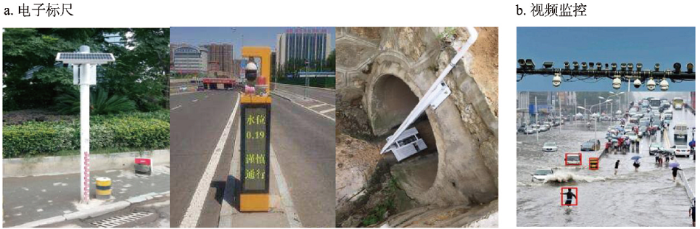
图2
观测城市内涝积水的电子标尺和视频监控器
Fig. 2
Electronic scales and video monitors for observing urban water logo
4 大科学(计划)预测“势”的实践与方法
4.1 集成“大数据观测—机器学习—机理模型”助力灾害事件演进过程的模拟
以城市内涝为例,内涝事件是降雨、地表环境、城市排水管网等复杂开放的多子系统相互作用的结果,其演进过程的预测一直以来都是难题。对于模型驱动的预测方法,例如,SWMM或Infowork ICM等水文/水动力模型,虽然可以刻画内涝机理,但受学科边界以及封闭系统假设的限制,其预测结果往往与实际相差较远。对于大数据驱动的预测方法,例如,基于3.3节视频监控的积水深度大数据联合机器学习进行预测,虽然预测结果更接近内涝实情,但缺少机理,制约了方法在时间、空间上的可推广性。
事实证明,单纯采用机理模型或大数据机器学习,都不能全面预测灾害态势的演进过程。下面从系统建模的不同层次,提出大数据观测、机器学习、机理模型集成的4类方法,为自然灾害态势预测提供新思路与新实践。
图3
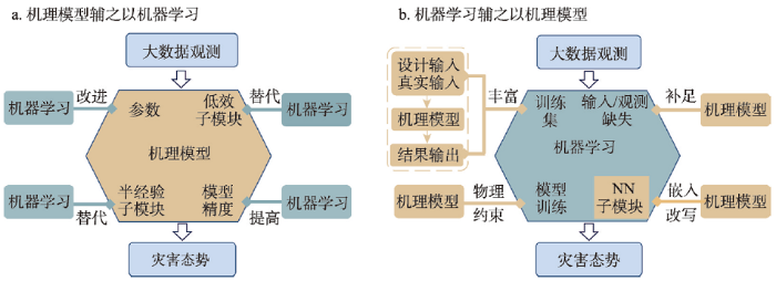
图3
灾害态势预测中机理模型与机器学习的整合
Fig. 3
Integrating mechanistic models and machine learning in disaster situational prediction
(4)基于集成学习的多模型整合。不同模型的预报结果间往往存在一定的时空互补性。集成学习方法(例如Boosting、Bagging、Stacking、贝叶斯模型加权平均等)可以将不同模型得到的预报结果进行整合,从而获得比单个模型更高的预报精度[29]。将集成学习引入到城市内涝模拟预报的研究中,有望进一步提高城市内涝的预报精度。
4.2 跨学科、跨领域合作助力区域或全球尺度灾害态势的综合预测
近年,预测自然灾害可能引发的非传统安全威胁,也逐步成为学界研究热点,例如,耦合人地关系、预判未来气候变化对全球社会经济的级联影响和远程效应。目前常见的方法是:根据自然灾害对当地社会经济的直接影响,将其量化为经济冲击、并输入到社会经济仿真模型中,预测灾害对全球社会经济系统的级联影响,以寻找最优配置路径,服务灾害的全球化防御、治理和应对。例如,Willner等整合全球气候模式、洪水模型和经济损失传播模型发现,2012年的贸易模式与2002年贸易模式相比,中国和欧洲都能有效缓解未来情景下洪水引发的级联影响,而对美国的缓解作用不显著[37];Zhang等整合全球环流模型、小麦生长模型和一般均衡经济模型发现,在未来2 ℃增温下,当全球小麦产量处于低谷时,位于低纬度且人口众多的小麦进口国的销售价格增幅将普遍超过高纬度小麦出口国[38]。
5 灾害态势感知研究的建议
5.1 关于大数据洞悉灾害“态”方面的建议
大数据能有效感知承灾体人及相关损失情况,是对传统自然灾害观测体系的有益补充。尽管国内外科研工作者在大数据态势感知上做了有效的探索和实践,但离实际应用还有一定距离。为切实加快自然灾害态势感知的研究与应用,切实推动新一代自然灾害社会治理体系与结构的形成,提高灾害治理的精准性、高效性和预见性,需要国家相关部门的大力支持和参与。
首先,受个人隐私、局部利益的影响,大数据共享是目前面临的首要问题;建议国家成立相关研究中心,推进灾害大数据的共享和应用,提升大数据的科学价值。其次,深度学习是大数据感知灾害态势的重要方法和手段;其中,知识库、训练库则是支持深度学习的重要核心和基础。而知识库、训练库的标记与建设又是项长期、基础的工作,短期难以见效益;建议国家相关部门或组织主持开展灾害灾情标准知识库、训练库的建设,服务国家灾害大数据态势感知的研究与应用。
在上述基础问题解决后,如何建立新一代国家自然灾害社会治理体系、治理结构与组织机制,如何将灾害网格化管理员和灾害态势专家研判机制纳入新的自然灾害应急管理体系等,都有待深入研究。
5.2 关于预测灾害“势”方面的建议
建议重视跨领域合作、重视全球治理的需求牵引。跨领域整合面临诸多限制条件,需要长期的实践与探索。相关研究可尝试从以下两方面推进。
(1)大数据观测—机理模型—机器学习的集成。4.1节提出了系列大数据观测、机理模型、机器学习集成的方法,为后续灾害态势预测研究和应用提供新思路。但相关的整合思路和方法还有很多,仍有待继续探索与实践。
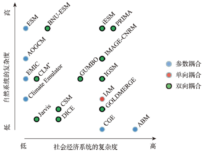
(2)灾害相关的自然与社会经济模型的耦合。针对此类典型的人地关系问题,后续可以尝试采取如下技术路径推动相关研究:① 参数耦合。将自然模型输出的灾害影响结果作为参数输入到社会经济模型(如4.2节第3段的案例),或将社会经济模型的输出作为参数输入到自然模型;其中常见的相对单一的自然或社会经济的模型,例如,图4中浅蓝色圆点标记的模型。② 单向耦合。在参数耦合基础上,对自然与社会经济模型进行封装,形成新的人地关系模型,但模型内人地关系的传输和流动依然是单向的;例如,图4中红色圆点标记的模型。③ 双向耦合:在模型中切实建立自然与社会经济要素间的双向流动和反馈关系[39-40],如图4中绿色圆点标记的模型。
图4
6 展望
新时代对自然灾害态势感知的深入探索,有望提高国家治理自然灾害的精准性、高效性和预见性,推动灾害管理和社会治理体系与结构的升级,最终推进地理科学的变革。20世纪计量革命与地理信息科学推动了地理研究的发展。近年,随着相关学科的快速发展及交叉融合,自然地理的要素化、人文地理的社科化、地理信息的技术化、地理智能的计算机化正逐步削弱着地理研究的特色,影响了地理学科的发展。自然灾害态势感知作为典型的自然—社会经济系统相互作用的科学问题,其研究应结合新时代全球气候变化的背景,在大数据智能化、大科学(计划)、全球化治理与应对的驱动下,发展自然灾害态势感知的新方法新实践。这不仅有助于提升国家自然灾害的全球应对水平和能力,还有望成为信息地理学的突破点,最终推动地理学领域的整体变革。
参考文献
Geographical synergetics: From understanding human-environment relationship to designing human-environment synergy
DOI:10.11821/dlxb201901001
[本文引用: 1]

From the perspective of achieving sustainable development in the world and building a community with a shared future for humankind in the "Anthropocene", and considering the complexity of the Earth's surface system, various disasters facing humanity, and future challenges of resource shortages and environmental risks, we proposed the development of "geographical synergy"—the mechanism, process and dynamics of the Earth's surface system and regional sustainability—in order to realize the transformation of geographical research from the explanation of human-environment relationship to the design of human-environment synergy. We discussed the scientific and technological questions of modern geography from the perspectives of integrating natural and social units, natural resources and natural disasters, achievements and faults of humans, and coupling of dynamic and non-dynamic processes and systems. We proposed the metrics of "consilience degree" as a measure of the complexity of integrated disaster reduction system based on the understanding of disaster system and the mechanism, process and dynamics of hazard and disaster formation. Using the principles of synergetic tolerance, synergetic constraint, synergetic amplification and synergetic diversification, we proposed to build an integrated disaster risk governance consilience model under the leadership of governments and with enterprises as the main body and the full participation of communities, with multiple optimization objectives of social consent maximization, cost minimization, welfare maximization, and risk minimization. Finally, we elaborated on the synergy of human and nature through "changing nature appropriately", with a case study on the Dujiangyan irrigation system, which enabled the win-win pattern of disaster reduction and benefit making.
地理协同论: 从理解“人—地关系”到设计“人—地协同”
DOI:10.11821/dlxb201901001
[本文引用: 1]
本文从地球进入“人类世”(Anthropocene)之后,实现世界可持续发展、建设人类命运共同体的角度出发,就地表系统的复杂性、人类面临的各种灾难以及将要面临的各种资源短缺和环境风险等问题,提出发展“地理协同论”,即:地球表层系统与区域可持续性机理、过程与动力学,以实现地理学研究从理解“人—地关系”到设计“人—地协同”的转变。着眼于“人类世”时代地球表层系统由多尺度、多过程等组成的复杂性,回顾了区域论、综合论、系统论等经典地理学理论,从自然单元与社会单元的结合、自然资源利用与自然灾害防御、人类功与过的评价、自然地图与行政地图间的关系、动力学与非动力学的耦合等主题入手,深入讨论了现代地理科学与技术问题。通过理解灾害系统及其致灾成害机理、过程和动力学,构建凝聚度指标,量化综合减灾系统的复杂性。利用协同宽容、约束、放大和分散原理,以灾害风险防范共识最高、成本最低、福利最大、风险最小化为目标,构建以政府为主导、企业为主体和社区全面参与的综合灾害风险防范凝聚力模式。在分析都江堰工程如何实现除害与兴利并举的基础上,综合阐释了“人类世”时代“适度改造自然”,以实现人与自然的协同。
Geography complexity: New connotations of geography in the new era.
DOI:10.11821/dlxb201807002
[本文引用: 1]
Since the 20th century, geography came into being with distinctive disciplinary characteristics by sustained effort of geographers. This paper puts forward predicament from cognitive and thought in the new era, and depicts new geographic characteristics from five aspects: new technology, new orders, new data, new approaches and new driving factors. According to new content of geo-regionality and new approaches of geo-comprehensiveness, the paper proposes that complexity research would be a successful new path in geography, and the complexity would be the third characteristic of geography. Then, the paper details some complex spatial patterns, complex time processes and complex spatio-temporal mechanisms in geography research. Based on the concept of a geographic complex system, this paper presents core issues and corresponding complex research tools. Finally, the paper puts forward new challenges and new requirements for geography in the new era.
新时代地理复杂性的内涵
DOI:10.11821/dlxb201807002
[本文引用: 1]
20世纪以来,经地理学者不断探索和努力,地理学已经形成了其特有的学科特征。首先从认知方法和思维角度,阐述了新时代地理学所面临的困境;从新技术、新秩序、新数据、新方法以及新动因等方面,诠释了地理学的新时代特征。其次,针对地理区域性的新内涵和地理综合性研究所需的新方法,提出了复杂性研究是地理学成功的新路径,并认为复杂性是地理学研究的第三特征。再次,重点讨论了地理研究存在的空间复杂格局、时间复杂过程和时空复杂机制,进而解释了地理复杂系统的基本概念,并就地理复杂系统的核心问题提供了相应的研究方法。最后,提出了新时代地理学面临的新挑战和新要求。
Thoughts on the recent development of physical geography
DOI:10.18306/dlkxjz.2018.01.001
[本文引用: 1]
Physical geography is the cornerstone of comprehensive study in geography. On the basis of reviewing the main research progress of physical geography, this article discussed the new research directions of physical geography. Driven by global environmental changes, physical geography and its branches have achieved significant progress. Recent progress in physical geography mainly includes research on the synthesis of physical geographic processes, land surface system integration, land-sea interaction, and physical geography application for regional ecological or environmental management. Physical geography needs to face the global climate change and human needs, explore new methods of technology application, carry out integrated multi-factor and multi-process research, develop geographical models, model future environmental dynamics and sustainable development, and serve the national priorities. In the process of physical geography development, we should pay more attention to the following frontier areas and directions: (1) geomorphology needs to focus on the study of geomorphology and global environmental change, and geomorphology and human activities; (2) biogeography needs to focus on the exploration of frontier fields such as attribute geography, global change biogeography, and to connect spatial distribution in biogeography and human needs under the background of change; (3) hydrology needs to integrate the multi-factor, multi-process, and multi-scale research, and to promote the development of ecological hydrology, social hydrology, and hydrological morphology; (4) physical geography needs to play a key role in the research of climate change, and serve major international research projects in climate change; (5) comprehensive physical geography research needs to meet national priority demands, focusing on the coupling of human-land system, resource and environment carrying capacity assessment, ecological security pattern, and ecological civilization construction; (6) physical geography needs to merge the natural and human elements and processes, develop complex system simulation models, and analyze the coupling mechanism of natural and human factors and the dynamic change of land surface system.
新时代自然地理学发展的思考
DOI:10.18306/dlkxjz.2018.01.001
[本文引用: 1]
自然地理学是地理学的基础学科,也是地理学综合研究的基石。本文在梳理自然地理学主要研究进展的基础上,思考了新时代自然地理学的发展方向。在全球环境变化驱动下,自然地理学及其分支学科在传承中得到新的发展。自然地理学近年来的研究进展主要表现为自然地理过程综合与深化、陆地表层系统集成、陆海相互作用和区域生态环境管理应用等方面。自然地理学及其分支学科的发展需要面向全球环境变化和人类需求,探索应用新技术新方法,开展多要素多过程集成研究,发展并完善地理模型,模拟和预测环境变化与可持续发展,服务于国家重大需求和政府决策。在发展过程中,亟待关注以下前沿领域与方向:①地貌学需要重点加强地貌学与全球环境变化及人类活动关系研究;②生物地理学有待深化属性地理学、全球变化生物地理学等前沿领域的探索,连接变化背景下的生物地理空间分布与人类需求;③水文学需要开展多要素、多过程、多尺度的综合集成研究,发展生态水文学、社会水文学、水文形态学等新兴学科领域;④自然地理学有待全方位介入气候变化研究,在气候变化国际重大研究计划、气候变化框架公约等方面发挥更加积极的支撑功能;⑤综合自然地理需要面向国家重大需求,聚焦人地系统耦合研究,在资源环境承载力评估、生态安全格局与生态文明建设等领域作出积极贡献;⑥自然地理学需深化耦合自然与人文要素及过程研究,建立发展复杂系统模拟模型,分析和模拟变化环境下的自然、人文要素耦合机制和陆地表层系统动态变化规律。
Disciplinary structure of geographic science in China
DOI:10.11821/dlxb202109001
[本文引用: 1]
The modern international and domestic science advancements have brought forward new opportunities as well as higher requirements to the development of geographic science in China. In planning the disciplinary structure of geographic science in the "Development Strategy of Discipline and Frontier Research in China (2021-2035)", we propose a modified disciplinary structure for the geographic science in the new era. The geographic science in China can be categorized into four secondary disciplines, i.e., integrated geography, physical geography, human geography, and information geography, considering the current situation and development outlook of geographic science. The tertiary disciplines under each secondary discipline are nearly fully developed, and a few quaternary disciplines under tertiary disciplines have already been widely accepted and used. We hope this new disciplinary structure can play a breakthrough role for improving the branches of geographic science, promoting the development of emerging disciplines under the framework of geographic science, and better serving the international and domestic development needs in the new era.
中国地理科学学科体系浅析
DOI:10.11821/dlxb202109001
[本文引用: 1]
新的国际和国内形势为地理科学带了新的发展机遇,同时也提出了更高的要求。以《中国学科及前沿领域发展战略研究(2021—2035)》地理科学的学科规划为契机,本文系统梳理了新时期地理科学的学科体系。根据地理科学现状和发展趋势,中国地理科学可划分为综合地理学、自然地理学、人文地理学和信息地理学4个二级学科,各二级学科下的三级学科也基本成熟,有些三级学科下的四级学科名称也在普遍使用。我们希望以这一新的学科体系为支点,完善地理科学的学科分支,推动地理科学框架下新兴学科的发展,更好地服务于新时期国际及国家的战略需求。
Information geography: The information revolution reshapes geography
DOI:10.1360/SSTe-2021-0184 URL [本文引用: 2]
信息地理学: 信息革命重塑地理学
Information geography: A new fulcrum of geographic ternary world
信息地理学: 地理三元世界的新支点
The European Commission launches the "Destination Earth" (DestinE) Plan
欧盟委员会启动“目标地球”DestinE计划
Geographic big-data: A new opportunity for geography complexity study
DOI:10.11821/dlxb201808001
[本文引用: 1]
Since 2010, big data has played a significant role in various fields of science, engineering and society. The paper introduces the concepts of geographic big-data, the fourth paradigm and nonlinear complex geographic system, and discusses interactive relationships of these concepts. It is proposed that geographic big-data and the fourth paradigm would become a new opportunity to research on geography complexity. Then the paper discusses how to use the methods of geographic big-data and complexity science to examine geography complexity. For example, based on big-data, a series of indicators of statistical physics fields could be constructed to describe the complex nonlinear characteristics of the real geographic world. Deep learning, complex network and multi-agent methods can be used to model and simulate the complex nonlinear geographic systems. These methods are important for a better understanding of the complexity of geographic phenomena and processes, as well as the analysis, simulation, inversion and prediction of complex geographic systems. Finally, the paper highlights that the combination of geographic big-data and complexity science would be the mainstream scientific method of geography in the 21st century.
地理大数据为地理复杂性研究提供新机遇
DOI:10.11821/dlxb201808001
[本文引用: 1]
大数据之风自2010年席卷全球,已在科学、工程和社会等领域产生深远影响。本文首先从地理大数据、第四范式以及非线性复杂地理系统3组基本概念出发,剖析上述3组概念之间的科学联系与相互支撑作用,提出大数据和第四范式为地理复杂性研究提供新机遇。其后,探讨如何利用大数据和复杂性科学的理论方法开展地理复杂性研究。基于地理大数据,可以通过统计物理学的系列指标描述现实地理世界的复杂非线性特征,同时,还可利用深度学习、复杂网络、多智能体等方法,实现复杂非线性地理系统的推演和模拟。上述方法对认知地理现象和过程的复杂性,对复杂地理系统的分析、模拟、反演与预测有重要作用。最后,提出地理大数据和复杂性科学相互支撑可能成为21世纪地理学的主流科学方法。
Social Sensing: A new approach to understanding our socioeconomic environments
DOI:10.1080/00045608.2015.1018773 URL [本文引用: 1]
Geospatial information diffusion model for inferring the demand intensity of assistance in information islands based on the Internet of intelligences for disaster mitigation
在救灾智联网中推测信息孤岛救助需求强度的空间信息扩散模型
A topic model based framework for identifying the distribution of demand for relief supplies using social media data
DOI:10.1080/13658816.2020.1869746 URL [本文引用: 2]
Emergency knowledge management and social media technologies: A case study of the 2010 Haitian earthquake
DOI:10.1016/j.ijinfomgt.2010.10.001 URL [本文引用: 2]
Rapid assessment of disaster damage using social media activity
Application and comparison of topic model in identifying latent topics from disaster-related tweets
主题模型在基于社交媒体的灾害分类中的应用及比较
DOI:10.12082/dqxxkx.2019.190046
[本文引用: 2]
“一带一路”沿线为自然灾害高发地区,且多为经济欠发达、抗灾能力弱的发展中国家。灾害发生时,挖掘和分析相关推特数据有助于开展应急救援、灾情评估、减灾防灾等工作,为中国国际救援与救助工作提供重要支撑。主题模型能在没有经验语料库的情况下,从海量灾害相关推文中快速聚合出对灾害救援、评估有价值的信息。本文采用BTM模型和LDA模型,对2013年海燕台风相关推文进行细粒度的主题聚类,分析2个模型的精度并测试它们对近似灾害主题的区分能力,并基于“需求相关”主题类的推文,通过地名匹配,分析了海燕台风发生过程中菲律宾物资、医疗等需求程度的空间分布。结果表明: ① 在区分主题近似的短文本时,BTM总体精度为0.598,LDA的总体精度仅为0.321,说明在海燕台风灾害推文的主题识别中,BTM模型的精度高于LDA模型;② BTM能够较好识别出“灾害地点相关”、“祈福相关”等较为精细的灾害主题;③ 经初步验证,基于“需求相关”主题文本生成的物资、医疗等需求的需求程度空间分布与实际需求情况基本相符。
A geographic approach for combining social media and authoritative data towards identifying useful information for disaster management
DOI:10.1080/13658816.2014.996567 URL [本文引用: 2]
Quantifying the dynamics of migration after Hurricane Maria in Puerto Rico
Triadic embeddedness structure in family networks predicts mobile communication response to a sudden natural disaster
Kinship networks are a fundamental social unit in human societies, and like social networks in general, provide social support in times of need. Here, we investigate the impact of sudden environmental shock, the M 7.0 2013 Ya'an earthquake, on the mobile communications patterns of local families, which we operationalize using anonymized individual-level mobile telecommunications metadata from family plan subscribers of a major carrier (N = 35,565 people). We demonstrate that families' communications dynamics after the earthquake depended on their triadic embeddedness structure, a structural metric we propose that reflects the number of dyads in a family triad that share social ties. We find that individuals in more embedded family structures were more likely to first call other family plan members and slower in calling non-family ties immediately after the earthquake; these tendencies were stronger at higher earthquake intensity. In the weeks after the event, individuals in more embedded family structures had more reciprocal communications and contacted more social ties in their broader social network. Overall, families that are structurally more embedded displayed higher levels of intra-family coordination and mobilization of non-family social connections.© 2021. The Author(s).
Toward data-driven, dynamical complex systems approaches to disaster resilience
Automatic estimation of urban waterlogging depths from video images based on ubiquitous reference objects
Video supervision equipment, which is readily available in most cities, can record the processes of urban floods in video form. Ubiquitous reference objects, which often appear in videos, can be used to indicate urban waterlogging depths. This makes video images a valuable data source for obtaining waterlogging depths. However, the urban waterlogging information contained in video images has not been effectively mined and utilized. In this paper, we present a method to automatically estimate urban waterlogging depths from video images based on ubiquitous reference objects. First, reference objects from video images are detected during the flooding and non-flooding periods using an object detection model with a convolutional neural network (CNN). Then, waterlogging depths are estimated using the height differences between the detected reference objects in these two periods. A case study is used to evaluate the proposed method. The results show that our proposed method could effectively mine and utilize urban waterlogging depth information from video images. This method has the advantages of low economic cost, acceptable accuracy, high spatiotemporal resolution, and wide coverage. It is feasible to promote this proposed method within cities to monitor urban floods.
EnKF and HYDRUS-1D based data assimilation experiments for improving soil moisture profile prediction
基于集合卡尔曼滤波和HYDRUS-1D模型的土壤剖面含水量同化试验
Real-time updating method for the state variables of Xinanjiang model based on ensemble Kalman filter
基于集合卡尔曼滤波的新安江模型状态变量实时修正方法
Deep learning and process understanding for data-driven earth system science
Combined hydraulic and black-box models for flood forecasting in urban drainage systems
DOI:10.1061/(ASCE)1084-0699(2006)11:6(589) URL [本文引用: 2]
Improving AI system awareness of geoscience knowledge: Symbiotic integration of physical approaches and deep learning
Physics-informed neural networks: A deep learning framework for solving forward and inverse problems involving nonlinear partial differential equations
DOI:10.1016/j.jcp.2018.10.045
[本文引用: 1]
We introduce physics-informed neural networks - neural networks that are trained to solve supervised learning tasks while respecting any given laws of physics described by general nonlinear partial differential equations. In this work, we present our developments in the context of solving two main classes of problems: data-driven solution and data-driven discovery of partial differential equations. Depending on the nature and arrangement of the available data, we devise two distinct types of algorithms, namely continuous time and discrete time models. The first type of models forms a new family of data-efficient spatio-temporal function approximators, while the latter type allows the use of arbitrarily accurate implicit Runge-Kutta time stepping schemes with unlimited number of stages. The effectiveness of the proposed framework is demonstrated through a collection of classical problems in fluids, quantum mechanics, reaction-diffusion systems, and the propagation of nonlinear shallow-water waves. (C) 2018 Elsevier Inc.
Urban flash flood forecast using support vector machine and numerical simulation
DOI:10.2166/hydro.2017.175 URL [本文引用: 1]
Uncertainty analysis of hydrological modeling using the Bayesian Model Averaging Method
基于贝叶斯模型加权平均方法的水文模型不确定性分析
Overview of the coupled model intercomparison project phase 6 (CMIP6) experimental design and organization
DOI:10.5194/gmd-9-1937-2016
URL
[本文引用: 1]
. By coordinating the design and distribution of global climate model simulations of the past, current, and future climate, the Coupled Model Intercomparison Project (CMIP) has become one of the foundational elements of climate science. However, the need to address an ever-expanding range of scientific questions arising from more and more research communities has made it necessary to revise the organization of CMIP. After a long and wide community consultation, a new and more federated structure has been put in place. It consists of three major elements: (1) a handful of common experiments, the DECK (Diagnostic, Evaluation and Characterization of Klima) and CMIP historical simulations (1850–near present) that will maintain continuity and help document basic characteristics of models across different phases of CMIP; (2) common standards, coordination, infrastructure, and documentation that will facilitate the distribution of model outputs and the characterization of the model ensemble; and (3) an ensemble of CMIP-Endorsed Model Intercomparison Projects (MIPs) that will be specific to a particular phase of CMIP (now CMIP6) and that will build on the DECK and CMIP historical simulations to address a large range of specific questions and fill the scientific gaps of the previous CMIP phases. The DECK and CMIP historical simulations, together with the use of CMIP data standards, will be the entry cards for models participating in CMIP. Participation in CMIP6-Endorsed MIPs by individual modelling groups will be at their own discretion and will depend on their scientific interests and priorities. With the Grand Science Challenges of the World Climate Research Programme (WCRP) as its scientific backdrop, CMIP6 will address three broad questions: – How does the Earth system respond to forcing? – What are the origins and consequences of systematic model biases? – How can we assess future climate changes given internal climate variability, predictability, and uncertainties in scenarios? This CMIP6 overview paper presents the background and rationale for the new structure of CMIP, provides a detailed description of the DECK and CMIP6 historical simulations, and includes a brief introduction to the 21 CMIP6-Endorsed MIPs.\n
Harmonization of global land-use change and management for the period 850-2100 (LUH2) for CMIP6
The human core of the shared socioeconomic pathways: Population scenarios by age, sex and level of education for all countries to 2100
DOI:10.1016/j.gloenvcha.2014.06.004 URL [本文引用: 1]
Income projections for climate change research: A framework based on human capital dynamics
DOI:10.1016/j.gloenvcha.2015.02.012 URL [本文引用: 1]
A 1 km global cropland dataset from 10000 BCE to 2100 CE
DOI:10.5194/essd-13-5403-2021
URL
[本文引用: 1]
. Cropland greatly impacts food security, energy supply,\nbiodiversity, biogeochemical cycling, and climate change. Accurately and\nsystematically understanding the effects of agricultural activities requires\ncropland spatial information with high resolution and a long time span. In\nthis study, the first 1 km resolution global cropland proportion dataset for\n10 000 BCE–2100 CE was produced. With the cropland map initialized in 2010 CE, we first harmonized the cropland demands extracted from the History\nDatabase of the Global Environment 3.2 (HYDE 3.2) and the Land-Use\nHarmonization 2 (LUH2) datasets and then spatially allocated the demands\nbased on the combination of cropland suitability, kernel density, and other\nconstraints. According to our maps, cropland originated from several\nindependent centers and gradually spread to other regions, influenced by\nsome important historical events. The spatial patterns of future cropland\nchange differ in various scenarios due to the different socioeconomic\npathways and mitigation levels. The global cropland area generally shows an\nincreasing trend over the past years, from 0×106 km2 in 10 000 BCE\nto 2.8×10⁶ km2 in 1500 CE, 6.2×10⁶ km2 in 1850 CE,\nand 16.4×10⁶ km2 in 2010 CE. It then follows diverse trajectories\nunder future scenarios, with the growth rate ranging from 16.4 % to\n82.4 % between 2010 CE and 2100 CE. There are large area disparities among\ndifferent geographical regions. The mapping result coincides well with\nwidely used datasets at present in both distribution pattern and total\namount. With improved spatial resolution, our maps can better capture the\ncropland distribution details and spatial heterogeneity. The\nspatiotemporally continuous and conceptually consistent global cropland\ndataset serves as a more comprehensive alternative for long-term earth\nsystem simulations and other precise analyses. The flexible and efficient\nharmonization and downscaling framework can be applied to specific regions\nor extended to other land use and cover types through the adjustable parameters\nand open model structure. The 1 km global cropland maps are available at\nhttps://doi.org/10.5281/zenodo.5105689 (Cao et al., 2021a).\n
Assessment of urban flood mitigation capacity on the Qinghai-Tibet Plateau: The case of Lhasa city
青藏高原城市洪涝缓解能力评估: 以拉萨市为例
Intergenerational inequities in exposure to climate extremes
DOI:10.1126/science.abi7339
URL
[本文引用: 1]
Young generations are severely threatened by climate change
Global economic response to river floods
DOI:10.1038/s41558-018-0173-2
[本文引用: 1]
Increasing Earth's surface air temperature yields an intensification of its hydrological cycle(1). As a consequence, the risk of river floods will increase regionally within the next two decades due to the atmospheric warming caused by past anthropogenic greenhouse gas emissions(2-4). The direct economic losses(5,6) caused by these floods can yield regionally heterogeneous losses and gains by propagation within the global trade and supply network(7). Here we show that, in the absence of large-scale structural adaptation, the total economic losses due to fluvial floods will increase in the next 20 years globally by 17% despite partial compensation through market adjustment within the global trade network. China will suffer the strongest direct losses, with an increase of 82%. The United States is mostly affected indirectly through its trade relations. By contrast to the United States, recent intensification of the trade relations with China leaves the European Union better prepared for the import of production losses in the future.
Increased wheat price spikes and larger economic inequality with 2 °C global warming
DOI:10.1016/j.oneear.2022.07.004 URL [本文引用: 1]
Research progress for the bidirectional coupling of the Earth system model and integrated assessment model
对地球系统模式与综合评估模型双向耦合问题的探讨
Integrated human-earth system modeling: State of the science and future directions
