

1 引言
港口腹地的扩张和争夺与港口体系的演化密不可分,是提升港口竞争力的关键。关于港口体系空间演化的研究最早起源于Bird提出的“Anyport”模型[1],该模型认为港口体系经历建立、扩张、专业化3个阶段,重点讨论港口发展与港城的扩张。Taaffe等将内陆运输网络的扩张与海港发展结合起来,提出港口体系演化的6阶段模型[2]。20世纪50年代起,高效、经济的集装箱运输逐渐成为现代交通运输的核心,Hayuth[3]和Slack[4]将多式联运、内陆交通走廊与港口腹地的扩大构建了联系。集装箱化和多式联运强化了港口间以及港口与内陆货物集散网络的合作。一方面,集装箱技术极大提升了货物转运效率,使得内陆货物装载中心成为港口运输系统中不可或缺的节点[5]。另一方面,全球多样化的生产和消费系统对传统高度集中的供应链系统发起挑战[6]。上述变化使海港拥挤等不经济现象愈发突显,也推动了内陆港口的发展和更遥远腹地的扩张。此外,受多式联运和溢出效应的影响,大型港口亟需在更广阔的区域空间中组织货物运输[7⇓-9]。为更明确地解释上述现象,Notteboom等提出了港口区域化这一港口体系演化的新阶段,并将其作为应对新兴挑战的有效战略。港口区域化实质上可以理解为一定区域范围内枢纽海港和内陆运输系统之间的高效物流整合,目的是缓解不经济现象和降低成本,提高港口竞争力。
港口区域化打破了传统港口体系局限于“港—城”腹地范围的认知,重构了港口体系的空间形态。海港的地理系统从沿海岸线分散、相互联系微弱的独立节点结构演变为门户港口与主要腹地中心紧密互动的走廊化网络结构[10]。港口腹地呈现出新特征:① 港口腹地地理范围更广,并出现不连续的孤岛型腹地[11]。② 内陆港口腹地的竞争加剧,腹地范围动态性增强,腹地分布存在更多的交叉重叠[12-13]。③ 港口腹地呈现出复杂的层次性。枢纽港和支线港、海港和内陆港的腹地格局存在差异。港口区域化主要通过公路及铁路网的陆路走廊和可通航的内陆河网所构建的水路走廊来实现[5],可分为由内而外和由外而内等两条路径[14]。一方面,内陆港口可主动维护和拓展直接腹地,并通过连接内陆港口和枢纽海港的可通航内河运输成为海港服务市场的重要参与者[15-16]。另一方面,枢纽海港也可利用内陆港口,通过有效整合港口间的水运及陆运,提高内陆装载中心的货物清关效率,扩大其间接腹地的竞争[17]。由此可见,除扩张直接腹地外,枢纽海港尝试将内陆港口的直接腹地转变为自己的间接腹地来提升竞争力。而间接腹地的定义并不强调专属和排他性,也就是说,若枢纽海港凭借港口竞争优势“夺取”支线港口的直接腹地并具有“腹地统治力”,则会形成垄断性间接腹地;若多个枢纽海港均能将该支线港口的直接腹地“夺取”,则会出现空间上重叠的竞争性间接腹地。
识别间接腹地以及分析直接腹地和间接腹地的演化特征是推动港口区域化的基础[18]。考虑到港口和腹地之间的实际物流数据难于获取,目前使用大数据直接划分港口腹地的研究仍然较少,并且很难同时兼顾内河航运和陆路运输两类大数据识别区域范围内的多个港口腹地。采用替代性指标模拟真实的港腹关系来划分港口腹地是当下港口腹地划分的主要方法。指标包括港腹间的运输距离或时间成本、港口影响力、港口规模、临港城市(简称港城)支持度、货物运输成本,方法主要有区位熵法、断裂点法、B-V理论、腹地烟羽模型、引力模型和场强模型等[19]。其中,场强模型使用成本加权距离法综合考虑了多种交通方式的时间成本,与港口区域化所提及的多式联运建设相契合;将港城社会经济条件纳入港口影响力评价指标中,用更准确的港口影响力来划分港口腹地[20]。目前港口腹地多集中于海港或内陆港口直接腹地的识别,甚少涉及间接腹地的定量划分,忽略了港口腹地的层次性和竞争性,主要面临以下困难:① 需要更科学地划分港口等级,厘清枢纽海港更倾向于将哪些支线内陆港口的直接腹地转化为其间接腹地;② 更精确地识别间接腹地的空间范围并区分垄断性和竞争性间接腹地;③ 定量识别间接腹地强调综合考虑内陆运输成本,除传统考虑陆路可达性以外,还涉及内河驳船的一体化[21],然而较少有研究尝试使用内河航运数据辅助腹地识别。
不同的港口自然条件、区域经济水平等均会对港口体系和港腹关系产生影响。相较于环渤海、珠三角两大港口群,长三角港口的腹地识别存在一定特殊性。① 长三角地区港口分布更为密集,内陆交通发达[22-23],且拥有长江天然黄金航道。相较于环渤海港口群严重依赖陆路交通和港铁联运[24]以及珠三角港口群主要依托丰富的水上喂给网络[25],腹地识别应同时考虑内河航运、陆路交通对腹地竞争的影响。② 长三角聚集了国内集装箱吞吐量排名第1、第2的上海港、宁波舟山港①(①该排名参考Alphaliner公布的2021年全球集装箱港口吞吐量排名前30的榜单。),两大龙头港口激烈竞争为腹地识别提供更生动的案例。③ 长三角区域一体化战略推进力度更大、成效更显著,也更利于讨论其港口区域化的腹地特征。与港口子群整合效率较低的环渤海港口群[24]和受特殊地理位置、制度背景影响的珠三角港口群[26]相比,长三角地区一体化发展较为成熟,区域内的交通、产业联系紧密,港口之间开展了有效的合作,不断促进长三角港口资源的整合[27]。然而,现有的长三角港口腹地研究仍存在一定局限:在无法获取大量动态货运数据的情况下,如何量化识别枢纽海港的间接腹地,如何更准确地刻画港口腹地的时空演化过程及长三角港口区域化特征。
因此,本文试图从集装箱港口的腹地演化来理解长三角港口区域化的特征,即期望解决科学问题是:① 长三角主要集装箱港口的直接腹地是怎样分布的,有什么演化特征?② 基于直接腹地与间接腹地之间的关系探究长三角集装箱港口的间接腹地呈现怎样的地理格局?本文尝试提出一种基于加权场强模型和班轮联系来定量识别港口间接腹地的方法,全面描绘港口区域化背景下长三角集装箱港口直接腹地与间接腹地的演化特征,为集装箱港口区域化发展提供政策建议。
2 研究方法与数据来源
2.1 研究区概况
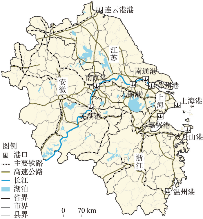
本文聚焦长三角地区,选取2019年集装箱吞吐量排名前10的港口作为研究对象,即上海港、宁波舟山港、连云港港、嘉兴港、温州港等5个海港和苏州港、南京港、南通港、芜湖港、无锡港等5个内陆港口(图1)。研究涉及的内陆港口更似欧陆的内河港口并兼有美国干港的特点[8],与海港间均有集装箱班轮往来,并能利用公路、铁路等运输方式实现联运。截至2019年底,以上10个港口的集装箱吞吐量占整个长三角集装箱吞吐量的比例超过95%,货物吞吐量占比超过65%。研究范围包括上海市、江苏省、浙江省和安徽省,并以县(区)为基本分析单元来划分腹地。根据数据可得性,仅将南京、上海划分成中心市区和若干市辖区,其他地级市辖区归到各自对应的地级市区,共获得了210个县(区)分析单元。
图1
2.2 数据来源
研究区行政边界等源自国家基础地理信息中心1∶100万标准地图,港口区位源于谷歌地球位置信息。陆路交通数据基于《中国交通旅游分省图集》《中国城乡公路网及城市行车导航地图全集》《沪苏浙皖鲁公路网及城市行车导航地图集》扫描并进行数字化处理。港口吞吐量数据来自《中国港口年鉴》。社会经济数据源自上海市、江苏省、安徽省、浙江省等的统计年鉴。集装箱码头航线数据来自《中国港口年鉴》和《中国航务周刊》。自2006年起,《中国港口年鉴》中的“中国港口主要集装箱码头航线表”开始详细记录长三角主要集装箱港口间的航线来往。因此,本文选择了2006年、2012年、2019年为观察时间节点,以月为单位来统计各港的班轮密度,极个别缺失数据根据各班轮公司或各港务集团网站数据补齐。
2.3 研究方法
(1)节点中心性。中心性用于表示各港口在航运网络中的重要性。度中心性反映了某一港口与其他港口联系的密切程度,本文尝试以港口间航线数量为权重,计算加权度中心性(Di)。介中心性(BCk)反映了某一港口在航运网络中的中转和枢纽功能,介中心性越高,港口在航运网络中的枢纽地位越强[28]。
式中:Di为港口i的加权度;ki为港口i的度;wij表示港口i和港口j之间航线数量,即加权值;BCk为港口k的介中心性;δij是港口i和港口j之间最短路径的总数;
表1 港口影响力评价体系
Tab. 1
| 一级指标体系 | 二级指标体系 |
|---|---|
| X1货物吞吐量 | |
| X2集装箱吞吐量 | |
| X3外贸货物吞吐量 | |
| X4港城经济水平 | X4-1第二产业占GDP比重 |
| X4-2第三产业占GDP比重 | |
| X4-3人均地区生产总值 | |
| X4-4贸易进出口总额 |
式中:Xi是标准化后的数值;X0是原始数值。
(3)港口可达性。港口腹地通常被认为是港口吸引其大部分业务的地理影响范围[34],因此运输成本通常是识别港口腹地的决定因素[35]。港口与腹地在货物运输网络中的可达性(距离或时间)可以反映港口—腹地两者互动的便利程度[36]。成本加权距离法用于记录每个栅格到成本最低的目标源的最低累积成本。该方法的优点是可以综合考虑多种交通方式,避免单一交通方式对可达性测算的影响。具体计算过程如下:① 根据设计标准、工程技术标准及相关研究,对不同交通方式下行驶1 km所需要的平均时间进行赋值(表2)。② 将不同交通方式的矢量图层按照0.3 km×0.3 km的大小栅格化并按照时间成本从大到小的顺序进行叠加,重叠部分只保留时间成本最小的栅格,得到综合时间成本栅格图[19]。③ 将10个港口设置为目标源点,使用ArcGIS中的Cost Distance命令计算10个港口到210个县(区)的最短通行时间。④ 将计算结果带入式(4)得到各港口的平均可达性值:
式中:Di是港口i的可达性;Tij为港口i和栅格j间的最短时间距离;N是栅格数。
表2 不同交通方式的时间成本
Tab. 2
| 对象 | 速度(km/h) | 时间成本(min/km) |
|---|---|---|
| 铁路 | 90 | 0.67 |
| 高速公路 | 100 | 0.60 |
| 一级公路 | 80 | 0.75 |
| 二级公路 | 60 | 1.00 |
| 三级公路 | 40 | 1.50 |
| 长江 | 25 | 2.40 |
| 其他道路 | 15 | 4.00 |
| 其他河流 | 1 | 60.00 |
| 湖泊 | 1 | 60.00 |
(4)场强模型。场强模型同时考虑交通网络和港口影响力来识别港口腹地,使得港口腹地划分更为科学[37]。本文采用的场强模型是在牛顿引力定律和距离衰减定律的基础上,改进了空间引力模型而发展起来的。该模型借鉴经典力学概念,认为港口腹地范围由港口影响力决定,且该影响力存在距离衰减效应。港口的影响力越大,对周围区域的吸引力就越大。每个港口的腹地可以看作是港口影响力的“力场”,影响大小就是“力场强度”[38]。同时,引力从中心向外围逐渐衰减,直至其值为0。本文将10个港口的影响力得分和交通可达性值代入模型中,如式(5)所示先计算各港口到各栅格的场强值(Figt),再根据式(6)计算给定港口在各县(区)单元内所有栅格的场强之和,得到Fict:
式中:Figt表示t时期港口i在栅格g的场强;Fict表示t时期港口i在某一县c内所有栅格的场强总和;Vit为t时期港口i的影响力得分;Digt表示t时期利用ArcGIS时间成本加权距离法计算的港口i到栅格g间的可达性;α为距离摩擦系数,本文α取值为2[20]。
(5)直接腹地识别。根据不同陆地区域与港口联系的紧密程度,港口腹地又可分为直接腹地与间接腹地。直接腹地通常位于港口附近,为同一港口所独有,更符合港口腹地狭义层面上的定义,即“能够用比使用另一个港口更便宜的成本或更短的时间到达的区域”[39]。直接腹地是一个港口稳定的货物来源,港口在该区域有绝对的“腹地统治力”,每个港口都有自己的直接腹地。根据最大隶属原则识别直接腹地(式(7)),如果某港口在这一县内达到最大总场强(Fct),则该县为这个港口的直接腹地。
式中:Fct为t时期某一县c内的最大场强。
识别间接腹地时,首先需要划分港口等级,确定拥有间接腹地的枢纽港口。由于内陆港口多扮演枢纽海港的卫星港来支持其发展[42],因此内陆港口在本文港口等级划分中均被认为是支线港。集装箱化促进了对规模经济的追求,也加剧了枢纽海港由于缺乏可扩张土地和处理大型船舶深水位而面临货物转运拥挤、清关效率低、大型集装箱船转运设施建设费用高昂等不经济性问题。不断拓展内陆腹地就是将这种不经济性外部化的过程[43]。因此,本文认为只有枢纽海港才有扩展间接腹地的实力和动机。本文基于港口的度中心性、介中心性和港口影响力等3个指标对5个海港进行聚类分析[44⇓-46],将长三角主要集装箱海港划分为两个等级:枢纽海港和支线海港。
其次,基于加权场强模型明确枢纽港更倾向于争夺哪些港口的直接腹地,进一步区分垄断性和竞争性间接腹地。将枢纽海港与其他支线港口间的班轮密度作为枢纽海港对其他港口直接腹地的影响权重,形成一个叠加了枢纽海港影响的加权场强值(式(9))。考虑到港间班轮密度数据数量级差距较大,且班轮密度越大越能增加枢纽海港对其他港口直接腹地的影响力,因此,采用SPSSAU区间化法(式(8))对原始数据进行无量纲化处理,将数据缩放到[1,2]区间内。最后,由于间接腹地并不一定为某个港口独有垄断,存在竞争性,本文尝试采用海港场强平均值作为划分间接腹地的标准(式(10))。比较枢纽海港在各县(区)的加权场强值是否高于所有海港在该县(区)场强值的平均值。若高于平均值,则该县(区)为该枢纽海港的间接腹地;若低于平均值,则该县(区)不属于该枢纽海港的间接腹地。若该县(区)仅为单个枢纽海港的间接腹地,则可称为该枢纽海港的垄断性间接腹地。若该县(区)为多个枢纽海港的间接腹地,则被识别为竞争性间接腹地。
式中:k为枢纽海港;l为支线海港;p为支线港口(包括支线内陆港口和支线海港);xt表示t时期内港口间班轮密度(班/月);xkpt为表示t时期内枢纽海港k与支线港口p之间的原始班轮密度;ykpt表示无量纲化后的班轮密度;
集装箱港口直接腹地和间接腹地的识别框架如图2所示。特别注意的是,在确定某内陆港口为特定枢纽海港的支线港后,内陆港口直接腹地的划分决定了哪些地方的货物被送到该内陆港口,并进一步喂给枢纽海港。如果没有直接腹地的划分,则难以进一步确定江海联运模式下内陆腹地的归属。
图2
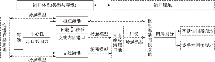
图2
港口区域化下港口腹地的识别框架
Fig. 2
Identification framework of port hinterland in port regionalization
3 结果分析
3.1 港口直接腹地演化
从整体水平来看,长三角10个主要集装箱港口的场强值呈增长态势,平均场强值从2006年的2.72增至2019年的3.69。各县(区)港口间的场强差异呈现先增大后减小的趋势,3年的场强标准差依次为10.674、13.468、12.343。从港口影响力来看(表3),上海港、宁波舟山港、苏州港3年均占据长三角集装箱港口前三甲,且排名保持稳定。上海港和宁波舟山港的差距在逐年缩小,两大港口间竞争越发激烈。长江内陆港口排名中的首位苏州港与宁波舟山港口间的差距在逐年递增,枢纽海港与内陆港口之间的实力差距拉大。在其他海港中,温州港和嘉兴港影响力逐渐稳定在下游,而连云港港从2006年的第9名跃升至2019年的第6名。除芜湖港始终排名位于下游外,其他内陆港口排名多位于中游且排名存在波动。从可达性水平来看,可达性均值由2006年的7.87 h降至2019年的6.82 h,可达性水平不断提升;3年的可达性标准差分别是3.674、3.420和3.310,港口间的可达性差异不断减小。
表3 2006年、2012年和2019年港口影响力分值
Tab. 3
| 港口 | 2006年 | 港口 | 2012年 | 港口 | 2019年 |
|---|---|---|---|---|---|
| 上海港 | 84.12 | 上海港 | 89.89 | 上海港 | 87.83 |
| 宁波舟山港 | 72.57 | 宁波舟山港 | 78.29 | 宁波舟山港 | 83.64 |
| 苏州港 | 61.95 | 苏州港 | 57.33 | 苏州港 | 54.83 |
| 无锡港 | 46.71 | 南京港 | 44.72 | 南京港 | 44.73 |
| 嘉兴港 | 41.30 | 连云港港 | 42.85 | 无锡港 | 40.59 |
| 南通港 | 40.50 | 无锡港 | 41.40 | 连云港港 | 40.12 |
| 南京港 | 37.42 | 南通港 | 37.02 | 南通港 | 38.33 |
| 芜湖港 | 36.47 | 温州港 | 33.84 | 温州港 | 32.42 |
| 连云港港 | 35.63 | 嘉兴港 | 32.96 | 芜湖港 | 31.30 |
| 温州港 | 35.46 | 芜湖港 | 26.81 | 嘉兴港 | 30.74 |
研究期内,长三角10大集装箱港口直接腹地范围变化明显(图3),直接腹地的扩张和收缩主要集中在上海港、宁波舟山港、南京港等附近。具体来看,上海港直接腹地最初时呈现明显的离散岛型腹地特征,2006年后扩张态势强劲且呈东北西南走向,夺取了原属于芜湖港、嘉兴港和宁波舟山港的直接腹地,主要是因为2006年后建成通车的G6021杭新景高速和国道G320强化沿线地区与上海港的陆路联系。得益于G15和G1512高速的延伸,宁波舟山港的直接腹地逐渐向浙江境内的西面和南面扩张,原有的非连续性腹地逐渐连接成片。南京港和芜湖港的直接腹地范围较大,一方面由于南京港和芜湖港位于长三角中部地区,该区域内港口分布较少;另一方面中部港口可达性水平较高,两个港口3年的可达性水平均处于1、2名。同时,南京港和芜湖港之间直接腹地竞争激烈。2006—2012年间南京港的直接腹地数量从33个增加到58个,其中向西和向南扩张的23个直接腹地均来源于芜湖港。南京港也超越芜湖港成为长三角直接腹地最多的集装箱港口。截至2019年,直接腹地数量仍位于首位的南京港的直接腹地略向北收缩,减少的腹地又被芜湖港重新夺回。嘉兴港受到上海港和宁波舟山港的挤压,直接腹地数量范围沿东北方向缩小。温州港直接腹地数量排名第3且略有收缩,主要竞争压力来源于宁波舟山港。苏州港、无锡港、南通港的直接腹地存在一定竞争,但整体稳定在苏南、苏中地区,其中无锡港直接腹地收缩较为明显。连云港港是长三角北部区域的唯一港口,直接腹地范围较为稳定,略有向东南扩张趋势。
图3
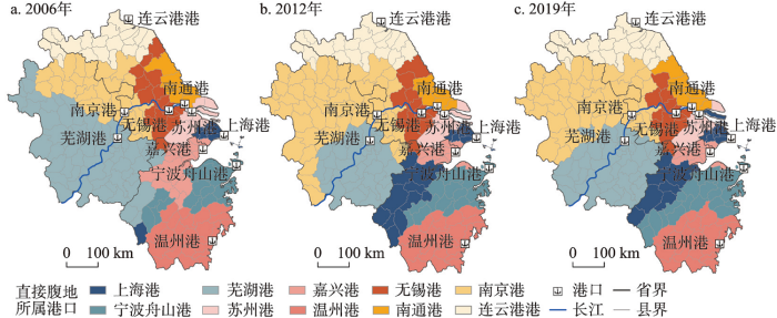
图3
2006年、2012年和2019年长三角集装箱港口直接腹地的演化
Fig. 3
Evolution of local hinterland of container ports in Yangtze River Delta in 2006, 2012 and 2019
综上所述,长三角集装箱港口直接腹地演化呈现如下特征:① 港口直接腹地竞争激烈,上海港、宁波舟山港两大海港和内陆港口南京港的直接腹地扩张态势强劲。② 港口直接腹地的扩展方向与重要交通干道分布高度耦合。③ 港口直接腹地范围与港口分布稀疏程度相关。如长三角地区北部、南部、中部区域港口分布较为稀疏,港口间竞争程度较小,基于可达性优势,附近的腹地很容易被就近的港口占领。④ 离散岛型腹地及非连续性腹地出现在港口直接腹地的识别过程中,且直接腹地的空间分布形态呈现出从不连续到连续的演化态势。
具有较大港口影响力优势的上海港与宁波舟山港竞争激烈,但两者的直接腹地数量均处于中下游水平。形成这一矛盾的原因,一方面与港口分布密集程度有关,两大海港均位于港口密集的长三角东部,港口间直接腹地竞争激烈。另一方面,港口区域化过程中枢纽港口不再仅仅注重争夺空间邻近的直接腹地,更广阔的更遥远的腹地成为争夺的重点[5]。因此,仅从直接腹地演化难以全面理解长三角地区集装箱港口区域化,而识别间接腹地及其演化过程成为了关键。
3.2 港口间接腹地演化
3.2.1 港口等级划分
基于2006年、2012年和2019年长三角地区10个主要集装箱港口的班轮联系数据,以及海港的中心性指标,使用SPSS聚类分析依次将3年时间截面上的5个海港分为枢纽海港和支线海港两类(表4)。上海港和宁波舟山港在3个时间点上均归为枢纽海港,连云港港、温州港、嘉兴港为支线海港,其余内陆港口为支线内陆港。在远洋集装箱船舶大型化的背景下,长三角航线为实现规模效益更倾向于转驳上海港与宁波舟山港等大型深水港。
表4 2006年、2012年和2019年海港中心性与港口等级划分
Tab. 4
| 2006年 | 2012年 | 2019年 | |||||||||
|---|---|---|---|---|---|---|---|---|---|---|---|
| 度中心性 | 介中心性 | 等级 | 度中心性 | 介中心性 | 等级 | 度中心性 | 介中心性 | 等级 | |||
| 上海港 | 77.78 | 49.54 | 枢纽海港 | 88.89 | 31.02 | 枢纽海港 | 100 | 14.91 | 枢纽海港 | ||
| 宁波舟山港 | 55.56 | 13.89 | 枢纽海港 | 66.67 | 12.97 | 枢纽海港 | 88.89 | 10.19 | 枢纽海港 | ||
| 连云港港 | 22.22 | 0 | 支线海港 | 33.33 | 0 | 支线海港 | 33.33 | 0 | 支线海港 | ||
| 温州港 | 22.22 | 0 | 支线海港 | 33.33 | 0 | 支线海港 | 44.44 | 0 | 支线海港 | ||
| 嘉兴港 | 11.11 | 0 | 支线海港 | 33.33 | 0 | 支线海港 | 44.44 | 0 | 支线海港 | ||
班轮航线数据显示,研究期内枢纽海港与其他支线港之间的联系广度和强度都大幅提升(图4)。2006年两大枢纽海港仅各与5个支线港有班轮来往,且每月的总班轮数量较低。2012年上海港增加了与无锡港、温州港、嘉兴港的班轮来往,在强化与苏州港和南京港等长江沿岸港口合作的同时,进一步加强与浙江省内集装箱港口联系。宁波舟山港则将班轮布局重点放在浙江省内,新增了大量与嘉兴港来往的班轮,实现与浙江省内港口来往班轮数量占比近9成。2019年上海港新增了与芜湖港的班轮,实现了班轮航线对长三角主要集装箱港口的全面覆盖,且总班轮数量相较于2012年增长近4倍。宁波舟山港也进一步增强了对无锡港、南通港等长江港口的重视程度。从港口间联系来看,上海港与长江沿岸港口间的合作更为密切,而宁波舟山港则更在与省内港口联系上更具优势。而且长三角地区10个港口集装箱吞吐量的赫芬达尔—赫希曼指数[47]从2006年的0.4804跌至2019年0.1655,显示了集装箱吞吐呈现分散化趋势。枢纽海港面对货物拥挤、运输压力、港间竞争的发展瓶颈,寻求支线港成为其进一步降低成本、提升竞争力的落脚点,枢纽海港与其他支线港之间联系强度的增加也揭示了这一变化趋势。
图4

图4
2006年、2012年和2019年枢纽海港与其他港口间班轮联系示意
Fig. 4
Liner traffic between hub seaports and other ports in 2006, 2012 and 2019
3.2.2 港口间接腹地识别与演化
基于班轮数据和场强模型,识别出2006—2019年的上海港和宁波舟山港间接腹地范围与演化特征(图5)。上海港垄断性间接腹地范围十分广泛,3个年份中分别将58.4%、69.7%、63.6%的长江沿线港口直接腹地发展为垄断性间接腹地,涉及到苏州港、南通港、无锡港、南京港等内陆港口的直接腹地及芜湖港北部直接腹地和嘉兴港部分直接腹地。空间范围主要集中在长三角北部地区,覆盖除连云港市及周围部分区县的江苏省中部和南部、安徽省合肥市以北地区和浙江省的嘉兴市和湖州市。从演化特征来看,2006年上海港垄断性间接腹地仍包含连云港西部直接腹地中的徐州市、宿州市和淮阴市;但2012年由于连云港港强化了对其直接腹地的影响力,上海港对这一区域的垄断力逐渐减弱。2012年上海港垄断性间接腹地范围最强劲的扩张来自于安徽省合肥市和六安市等地区。这是由于2012年南京港与芜湖港在直接腹地的竞争中处于优势,占领了安徽省大部分县(区);同时,2012年上海港与南京港的班轮来往密切,班轮数量占比近23%,很大程度上提升了上海港对南京港直接腹地的“统治力”。宁波舟山港垄断性间接腹地有限,主要来源于温州港北部的直接腹地。空间范围主要集中在浙江省境内,包括丽水市和台州市部分区县。从演化过程来看,3个时间节点上宁波舟山港的垄断性间接腹地范围差异并不明显,腹地范围的变化主要取决于宁波舟山港与温州港间的竞争结果。
图5
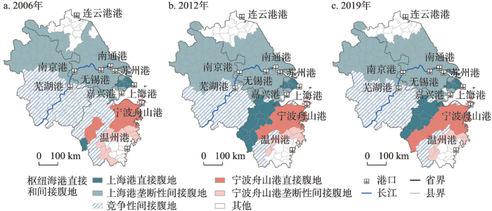
图5
2006年、2012年和2019年长三角枢纽海港直接和间接腹地演化示意
Fig. 5
Evolution of local and distant hinterland of hub seaports in Yangtze River Delta in 2006, 2012 and 2019
两大枢纽海港的竞争性间接腹地主要集中在芜湖港和温州港的直接腹地上,空间范围包括安徽省中部、南部以及浙江省西部和南部。从演化过程来看,研究期内,竞争性间接腹地范围呈现先减小后扩张的趋势。可见,集装箱化引发了港口腹地向大面积重叠或可竞争的态势发展。2006—2012年竞争性间接腹地主要有3种演化方向:① 中部的竞争性间接腹地(杭州市和衢州市)成为了上海港的直接腹地。② 中南部金华市被纳入宁波舟山港直接腹地范围,致使宁波舟山港的直接腹地从不连续的块状分布成为连续的整体型腹地。③ 北部的竞争性间接腹地被上海港吸收为其垄断性间接腹地。2012—2019年竞争性间接腹地的变化主要集中在安徽省中部,六安市区、金寨县、霍山县、肥西县等地又重新成为两港的竞争性间接腹地。值得注意的是,该区域属于和上海港班轮联系密切的南京港的直接腹地范围内,与2012年不同,2019年时宁波舟山港在港口影响力得分和可达性方面大幅提升,宁波舟山港在上述县(区)的场强大小也超越了所有海港的平均场强水平,致使该区域从上海港的垄断性间接腹地发展为竞争性间接腹地。再从两港在不同区域竞争性间接腹地的差异来看,宁波舟山港在浙江省内间接腹地上的场强值在3个时间点上均高于上海港,而上海港则在芜湖港的直接腹地上更有优势。
图5中其他腹地为支线海港连云港港与温州港的部分直接腹地,该区域并未被两大枢纽海港捕获成为间接腹地。这可能是由于这两个海港分别位于长三角地区港口分布稀疏的北、南两端,在各自直接腹地上的场强值大小相对其他海港极具优势。且其直接腹地与枢纽海港间通行时间成本较大,两港枢纽海港对其腹地的吸引力较弱。以温州港为例,即使2019年时两大枢纽港均与其有较为频繁的班轮来往,仍难以将靠近温州港的部分地区进一步发展为自己间接腹地。
4 结论和讨论
4.1 结论
经济全球化和集装箱化背景下,受土地制约、成本竞争、服务优势等因素影响,基于内河运输、多式联运等物流方式来拓展集装箱供应链,这已经成为港口区域化背景下提升港口竞争力的重要途径之一。枢纽海港通过加强与内陆港口的合作联系来稳固自己的集装箱源,将腹地范围从港口周边的直接腹地进一步延伸到内陆的间接腹地,港口竞争逐渐从沿海地区转向内陆地区。港口腹地争夺是影响港口竞争力的关键之一,识别港口腹地范围有利于摸清港口腹地演变趋势、制定港口发展战略,推进港口区域化发展。本文聚焦于长三角地区吞吐量排名前10的集装箱港口,综合考虑港口影响力、交通可达性、班轮密度等指标,基于场强模型刻画了2006年、2012年、2019年3个时间截面上10个集装箱港口的直接腹地,探索通过加权场强模型来定量识别枢纽海港的间接腹地并分析其演化格局。研究表明长三角主要集装箱港口的腹地演化呈现以下港口区域化特征:
(1)拓展直接腹地仍是长三角集装箱内陆港口和海港发展的重要策略之一。长三角集装箱港口的直接腹地范围变化明显,扩张和收缩主要集中在上海港、宁波舟山港、南京港等附近,空间格局从不连续分布逐渐演化为连续分布。直接腹地范围与港口布局的稀疏程度高度相关,直接腹地扩张方向往往与重要交通干道线高度耦合。作为枢纽海港的上海港和宁波舟山港的直接腹地数量处于港口群的中下水平,其中宁波舟山港的直接腹地范围比上海港的更广阔。
(2)捕获垄断性间接腹地是长三角两大枢纽海港推进港口区域化发展的重要举措之一。上海港和宁波舟山港呈现出差异化的垄断性间接腹地格局。研究期内,上海港将除芜湖港外的长江内陆港的直接腹地纳入自己的垄断性间接腹地,空间范围比较广阔,覆盖江苏省大部分和安徽省北部地区。而宁波舟山港主要在浙江境内扩张垄断性间接腹地,其主要来源于温州港的直接腹地,空间范围明显小于上海港的。
(3)间接腹地范围的重叠性和竞争性也是长三角两大枢纽海港区域化的重要表象之一。两大枢纽海港竞争性间接腹地的争夺集中在芜湖港和温州港的直接腹地上,研究期内,竞争性间接腹地相对稳定地锁定在安徽中南部和浙江西南角,范围大小呈现先期整体减小后期局部扩张的趋势。特别是安徽中南部地区在研究期内一直是两大枢纽海港的竞争性间接腹地,而位于浙江西部的竞争性间接腹地在研究期后期分别被两个枢纽海港扩张为其直接腹地,这在一定程度上显示上述两个地区都是港口腹地竞争最为激烈的区域。
4.2 讨论
对港口直接腹地与间接腹地(包含垄断性和竞争性)的争夺而呈现出腹地范围的扩张与收缩是长三角港口区域化的进程缩影。长三角港口群的区域特色在于同时聚集了国内集装箱吞吐量排名前2的上海港、宁波舟山港。两大龙头枢纽港的集中分布加剧了港口腹地的激烈竞争,形成了明显的直接腹地争夺和竞争性间接腹地广阔分布的特征。同时,两港依托不同的区域化战略,形成了差异化的港口腹地格局。受到有限土地和水深条件的约束,上海港的腹地发展策略更倾向于拓展距上海港较远的腹地。一方面,上海港充分利用长三角完善的陆路交通网将浙江西部纳入自己的直接腹地范围;另一方面,依托“长江战略”将长江沿线内陆港口的直接腹地收入到自己的垄断性间接腹地范围,形成沿长江广泛分布的腹地格局。上港集团先后与长江沿岸的南京港、芜湖港以及南京港集团、长航集团、江苏省港口集团等签订合作协议,开通定期的江海联运集装箱航线[48]。相比之下,宁波舟山港虽然并没有众多支线内陆港口的喂给,但有着先天的港口优势,港口陆域广阔,且省内制造业发达、陆路交通网络完善。再加上浙江省陆续出台直接补贴物流企业等经营主体的海铁联运优惠政策[49],进一步降低物流成本。因此,宁波舟山港的腹地发展策略一方面倾向于借助行政力量整合省内货源,伴随着浙江自贸区扩区的进程,将腹地范围扩展到浙江全省,形成直接腹地、垄断性间接腹地在省内连续分布的空间格局。另一方面充分利用海铁联运和水铁联运,开通了合肥、芜湖、广德等海铁联运专线并推进淮河干流航道、芜申运河等航道建设,强化与安徽沿江港口合作,将自己的竞争性间接腹地拓展到了安徽省中南部。值得注意的是,两大枢纽海港的竞争性间接腹地主要集中在芜湖港和温州港的直接腹地上,即皖中南和浙西南地区。这主要是由于两大枢纽海港与芜湖港、温州港的班轮联系密度较为接近,且到两个地区的交通可达性差距不大,导致腹地竞争持续且激烈。总体来说,上海港和宁波舟山港根据自身优势条件,选择了不同的腹地发展策略,其腹地范围从港口周边逐渐深入内地,推动了海港与内陆地区的物流整合,进而实现了港口区域化的发展,也将港口腹地的竞争性进一步推向高峰。
本文对集装箱港口区域化知识体系的贡献在于:① 提出港口区域化阶段下识别直接腹地、垄断性间接腹地和竞争性间接腹地的分析框架,直观地描绘了长三角集装箱港口腹地演化的空间格局。通过分析直接腹地与间接腹地的演化,为理解长三角集装箱港口区域化提供了一种新的空间视角。② 基于枢纽海港与内陆港口间的班轮密度、港口影响力、可达性、节点中心性等指标来定量识别枢纽海港间接腹地,这有助于推动长三角集装箱港口区域化的定量研究。
研究结论对实施长三角集装箱港口区域化战略有两点政策启示:① 集装箱枢纽海港首先应加大港口基础设施的投入,最大程度地发挥集装箱枢纽海港的规模优势。其次,重视与集装箱内陆港口合作,深耕遥远内陆市场,鼓励大型物流集团、集装箱码头运营公司和航运企业等关联企业参与重要内河集装箱码头的建设,建立可控的集装箱转运体系,提升参与间接腹地竞争的可持续性。② 集装箱内陆港口一方面应积极提升港口自身竞争力,稳固陆路交通走廊,扩张港口的直接腹地;另一方面要利用好长江等内河航运优势,加强与枢纽海港之间的合作,主动嵌入长三角集装箱供应链网络。
参考文献
Transport expansion in underdeveloped countries: A comparative analysis
DOI:10.2307/212383 URL [本文引用: 2]
International transportation in North America and the development of inland centers
DOI:10.1111/j.0033-0124.1990.00072.x URL [本文引用: 1]
Rationalization and Concentrations of the U. S. container port system
DOI:10.1111/j.0033-0124.1988.00279.x URL [本文引用: 1]
Port regionalization: Towards a new phase in port development
Spatial organizational mechanism of port and shipping service industry in a hub port city: A case study of Shanghai
DOI:10.11821/dlxb201712008
[本文引用: 1]

<p>Based on the theory of industry evolution and scale coupling, this article constructs a multi-scale unified theoretic analysis framework of spatial organizational mechanism of port & shipping service industry. On the global scale, an induction and deduction analysis has shown that under the influence of economic globalization, technological reform, industrial organization reform, regional strategic responses, and other multi-level factors and mechanisms, a hierarchical assignment structure has been formed in port & shipping service industry, with a minority of hub port cities becoming pivotal nodes of port & shipping service agglomeration and development, of which the structural gravity has been shifted from transportation & warehousing to agent & technical services, and subsequently to advanced port & shipping service enterprises. On the urban scale, owing to the differences of the intrinsic attributes of port & shipping service industry and the location endowment, the spatial layout of port and shipping service enterprises has displayed a distribution pattern, which automatically assigns advanced class, agent & technical class and transportation & warehousing class respectively from the center to the periphery of a city. The framework analyzed above has been used in addition with the positional data of port and shipping service enterprises in the city of Shanghai from 1996 to 2014 to corroborate an empirical study on the processes, structures, and patterns of the city's spatial organization of port and shipping service industry. The statistical analysis suggests that the proportions of transportation & warehousing class, agent & technical class, and advanced class of port & shipping service enterprises have been converted from 77.81%, 20.15%, and 2.04% to 47.78%, 46.20%, and 6.03%, respectively, from 1996 to 2014, with a manifest trend of industrial upgrading to the higher end of the value chain. The methodological approach of this article includes a circle distance analysis, a hotspot analysis and a kernel density estimation, which collectively evince that: (1) the tendency of suburbanization of transportation & warehousing enterprises has been strengthened; (2) the agglomeration trend of the agent & technical enterprises remains strong, along with a noticeable diffusion pattern with intermittent character; (3) the advanced enterprises are highly polarized to the center, with warm spots developing steadily in the peripheral areas. As the final stage of the analysis, this article enunciated the macro and micro mechanisms that have affected the structural and distributional patterns indicated above.</p>
枢纽港口城市港航服务业空间组织机理: 以上海市为例
DOI:10.11821/dlxb201712008
[本文引用: 1]
基于全球生产网络理论和地理尺度关联思想,本文构建了一个多尺度相统一的港航服务业空间组织理论分析框架。归纳演绎表明,在全球尺度上,受经济全球化、技术变革、产业组织变革和国家/地方(政府)战略响应等多层级因素与机制的相互影响,少数枢纽港口城市成为港航服务业集聚发展的主要节点,其产业结构重心由运输仓储类向代理与技术服务类、高级服务类逐次转移;在城市尺度上,受港航服务业不同行业的内在属性以及城市不同区位的禀赋特性的共同作用,从中心向外围总体呈现高级服务类—代理与技术服务类—运输仓储类圈层式分布格局。以上述框架为指引,依据近20年来上海市港航服务业企业数据,对其结构演替与格局演化进行了实证分析。统计分析表明,1996-2014年运输仓储类、代理与技术服务类和高级服务类企业数占企业总数比率分别由77.81%、20.15%和2.04%变动为47.78%、46.20%和6.03%,产业结构明显向价值链高端攀升。圈层、热点分析和核密度估计显示,运输仓储类企业近郊区化布局趋势逐步强化;代理与技术服务类企业中心集聚明显,跳跃式扩散初显;高级服务类企业高度中心极化,外围温点初步发育。由此进一步分析了影响结构演替和布局演化的宏观与微观机制。
The port network as a new stage in port development: The case of Rotterdam
DOI:10.1068/a300143
URL
[本文引用: 1]
As a result of fundamental developments in economy, technology, and society the location behaviour of economic actors is changing. Traditional boundaries no longer hold. One category of locations confronted with these changes is seaports. Port-related activities are increasingly located in secondary centres at a distance from the port, resulting in the development of a ‘port network’. The rise of port networks is considered a new stage in the development of ports. To cope with the transition towards the new stage, port authorities need to revise their strategy. In this paper, the development of port networks is considered as an example of new spatial patterns and organisational structures in a borderless world. The factors behind the rise of port networks are identified and the contours of a new port strategy outlined. The theoretical model is illustrated by the case of Rotterdam.
The economic impact of inland ports on regional development: Evidence from the Yangtze River region
DOI:10.1016/j.tranpol.2022.08.012 URL [本文引用: 2]
Review and prospect of the research on spatial connection between port and city
DOI:10.11820/dlkxjz.2010.12.004
[本文引用: 1]
The port, the key link of the water transportation and the node of amphibious transportation, has a prominent significance. Therefore, the spatial relation between harbor and city has covered many aspects of port city. Taking the port-city and the urban spatial relation which depends on port as the research subject of this paper, through contrasting the similarities and differences in the domestic and foreign researches and the research characteristics of geography, urban science and other different disciplines, the pattern-process-mechanism of the port-city spatial relations is grasped. The paper also discusses the port-city spatial model, spatial growing rule and historical development of cities and ports, and the main arguments in the researches on the domestic and foreign port-city spatial relations. Finally, the development process and other aspects are summarized and appraised, and the prospect and the trend of development are clarified. Suggestions for future research are also proposed.
港口与城市空间联系研究回顾与展望
DOI:10.11820/dlkxjz.2010.12.004
[本文引用: 1]
港口作为水运的中心环节和水陆交通节点,本身空间意义突出。因此,港口与城市的空间联系涵盖了港口城市的诸多方面。将港口与其所依托城市的空间关系作为主题,通过对比国内外研究异同和地理学、城市科学等不同学科研究特色,把握港城空间关系演变的过程—格局—机理。分别从港—城空间模型、港口与城市空间成长规律及其机理、港口演化与城市兴衰的历史地理解析、港与城的空间融合及空间规划、港口发展新因素对城市的空间影响等方面解析国内外港口与城市空间联系研究的发展脉络和主要论点,总结现有研究的基本范畴和理论范式,最后在分析现有研究不足的基础上展望相应研究趋向,为今后的港口与城市空间联系研究提供一个分析架构。
Traffic inequality in seaport systems revisited
DOI:10.1016/j.jtrangeo.2004.12.003 URL [本文引用: 1]
Theoretical model of container port system and its empirical research in Yangtze River Delta
DOI:10.11821/yj2011030002
[本文引用: 1]
The popularization of container transport technology impacts greatly the development of container port system whose evolution theory focuses the influence of technology on spatial and temporal changes of port system, which is of important significance to the construction of port. Based on the review of research progress, we integrate the theoretical model of container port system proposed by Hayuth and Notterboom, in light of the newest characters and developing mechanism of port system in the world, and design an revised theoretical model of container port system which is divided into five spatial-temporal developing stages, including pre-containerization, introduction and experiment of technology, popularization of technology and centre of throughput, hub port, diffusion and offshore hub, regionalization of port. We describe the spatial characteristics of container port system in each developing stage in detail. Its last two developing stages are diffusion and offshore hub and regionalization result from the integrated effect of five aspects, including local restriction of hub port, change of container shipping network, integration of modern logistics resources, inland distribution network and inland terminal, macro-control of the Central Government and market mechanism of port construction. Then, we choose the Yangtze River Delta as a case study, and analyze the evolving process of container port system, especially its changes of spatial characteristics and developing mechanism, to validate the theoretical model of container port system.
现代集装箱港口体系演进理论与实证
The identification and measurement of seaport spatial effect in China
DOI:10.11821/dlxb201402008
[本文引用: 1]
Coastal ports have become a geographic hub between global production chains and local network links under the promotion launched by globalization and world industrial transfer. At the same time, port development evolution affects economic development of hinterland, when promotes the transportation system itself and spatial evolution. Firstly, this paper proposes the conception and connotation of harbor spatial effect from the angle of economic geography. The dynamical structure and forming elements are elaborated from three angles including port's potential energy, port-hinterland gravitation and action passageway. Secondly, the paper establishes the measurement model based on the dynamical structure of harbor spatial effect. Thirdly, the index of harbor spatial effect is calculated with the sample of coastal ports of east China by using the measurement model of harbor spatial effect. The study chooses port throughput, container throughput and foreign trade throughput to show the distribution pattern of transport spatial effect from port alongside the coast to hinterland, while it also chooses the city industry of port, foreign trade and financial indicators to show the distribution pattern of non-transport effect from port alongside the coast to hinterland. Furthermore, compared with the characteristics and differences of different districts, the accuracy and maneuverability of the model is testified. The results indicate that the model can nicely identify port economic spatial effect of different cases in macro-scale. The model has a guiding significance for revealing the location essence of port, comparing the tendency of approaching the port in different districts and describing the space connection of urban region system in port-hinterland city.
中国海港空间效应的识别与测度
DOI:10.11821/dlxb201402008
[本文引用: 1]
在全球化和世界产业转移浪潮推动下,沿海港口已成为全球生产链条与地方网络链接的地理枢纽。与此同时,港口发展演化在推动港口自身运输体系及港口空间演化的同时,对腹地经济发展产生重大影响。首先,从经济地理学视角,提出海港空间效应的概念及其内涵,从港口势能、港—腹引力、作用通道三个方面阐述海港空间效应的动力结构和形成要素。其次,以海港空间效应的动力结构为理论依据,建立海港空间效应的测度模型。最后,以我国东部沿海港口为研究样本,运用海港空间效应测度模型,得到海港空间效应指数。以港口吞吐量、集装箱吞吐量、外贸吞吐量为指标表征沿海港口对腹地的运输效应分布格局,以港口城市工业、对外贸易和金融指标表征沿海港口对腹地的非运输效应格局,对不同区域特点和差异进行比较分析,验证模型的准确性和可操作性。结果表明,模型可较好地从宏观尺度识别不同港口及其腹地的港口经济空间效应,对于揭示港口的区位本质,比较不同区域的临港化倾向,刻画港口—腹地型城市地域系统的空间联系具有指导意义。
The evolution course and mechanism of the port system along the Yangtze River
DOI:10.18306/dlkxjz.2015.11.010
[本文引用: 1]
The Yangtze River port system is an important support for the Yangtze River Economic Belt (YREB). First, this article investigates the historical development of the Yangtze River port system. The results show that with the gradual overlapping of water transfer hinterlands and water-land transfer hinterlands, the port system has experienced five stages of development so far: the origin and emergence of the ports, the sprout of the port system, the preliminary formation of the port system, the final formation of the port system, and the upgrading of the port system. Based on empirical evidence, the article summarized the formation mechanism of the port system of the Yangtze River. It is believed that the main mechanism of the formation of the port system is the long-term competition for water transfer hinterlands and water-land transfer hinterlands, especially the competition for water transfer hinterlands. Competition of ports for transit hinterlands increasingly deepens and broadens over time. According to the basic pattern of the port system formation and development revealed by the theoretical and empirical research, policy discussions are put forward concerning the development of the Yangtze River port system and the comprehensive transportation system of the Yangtze River Economic Belt.
长江沿岸港口体系的形成过程与机制
DOI:10.18306/dlkxjz.2015.11.010
[本文引用: 1]
长江沿岸港口体系是长江经济带的重要支撑。本文首先对自古以来长江沿岸港口体系的形成发展过程进行了科学实证,发现港口体系经历了“港口的起源与产生—港口体系萌芽—港口体系雏形—港口体系形成—港口体系升级”5个阶段。依据实证分析,对长江沿岸港口体系的形成机制进行了归纳演绎,认为相关港口对水水中转和陆水中转腹地的长期相互竞争是导致港口体系形成的主要机制,其中对水水中转腹地的竞争尤为关键,而港口对中转腹地的竞争随时间推移不断向更深层次更广领域推进。最后从政策层面,对长江沿岸港口体系和长江经济带综合运输体系建设的若干问题进行了讨伦。
The directional development of intermodal freight corridors in relation to inland terminals
DOI:10.1016/j.jtrangeo.2011.07.010 URL [本文引用: 1]
Inland shipping to serve the hinterland: The challenge for seaport authorities
The competitiveness of seaports is predominantly affected by factors external to the ports themselves, connected mainly with the quality of the hinterland and foreland infrastructure. Measures taken in these areas are reflected in the main objectives of the port strategies. Concurrently, the measures may have adverse environmental impacts (pollutant emissions, noise, land occupancy, etc.) and deteriorate the life quality of the port city’s communities. Therefore, measures taken by seaport authorities to improve their competitiveness must also heed the idea of sustainable development (sustainable port strategy). The answer to this challenge is the idea of green ports, being an element of the corporate social responsibility (CSR) strategies of seaports. One of the elements of this concept is promoting more environmentally friendly transport modes/transport chains in serving the hinterland as an alternative to road transport. Inland shipping is the most environmentally friendly and also cost-competitive mode of transport. Therefore, a modal shift from road to inland waterways is one of the elements of the European Union sustainable transport policy, as well as also gaining importance in the development policies of seaport authorities as an element of a green port strategy. However, this issue has been relatively rarely addressed in the seaport economics literature. In particular, there has been a lack of studies that would make it possible to answer the question of what kind of action should be taken by seaport authorities in order to increase the share of inland shipping in hinterland transport. This article aimed to develop a concept of a promotion policy to be applied by seaport authorities to increase the share of inland shipping in hinterland transport. The study used the elements of a multiple case study design method which included the following seaports: Antwerp, Rotterdam, Hamburg, and the Marseilles–Fos port complex. This article was dedicated to identifying, analyzing, and classifying the policies implemented by these European seaports to promote inland waterway transportation. The research showed that these actions were quite similar in terms of their scope. The actions were classified as external and internal initiatives. The most common external actions included initiatives that improved the quality of inland waterways and the quality of shipping connections with the hinterland. Internal initiatives focused on improving the port’s infrastructure for barges and on implementing an appropriate information policy. The presented concept of a promotion policy can be a road map for all port authorities aiming to improve the quality of inland shipping as a mode of hinterland transport.
Dry ports: Research outcomes, trends, and future implications
The impact of dry port operations on container seaports competitiveness
Research prospect and progress of port geography in China
DOI:10.13249/j.cnki.sgs.2021.04.007
[本文引用: 1]
Based on the bibliometric tool—CiteSpace, this article analyzed the research institutions, research teams, research hotspots and research stages of Chinese Port Geography, and summarized the general characteristics of Chinese Port Geography research. The study found that Chinese Port Geography has achieved a rapid development and the research methods and contents of Chinese Port Geography are diversified increasingly, some of the emerging research perspectives such as shipping companies and shipping networks, green low-carbon ports etc, are starting to rise, and become an important research direction of Port Geography gradually, besides that there is a lack of close cooperation and high academic consensus between research institutions in Chinese port geography. Finally, focusing on the discipline development of Port Geography and the needs of national strategy, we discussed the future development trend of Chinese Port Geography from the following 5 aspects: to improve the concept and basic category of port geography; to expand the theoretical innovation research in a global perspective; to strengthen the mechanism exploration based on microscopic perspective; to discuss the practical and theoretical exploration of disciplinary integration and to intensify a policy and practical exploration for national strategy.
中国港口地理学研究进展与展望
DOI:10.13249/j.cnki.sgs.2021.04.007
[本文引用: 1]
基于CiteSpace文献计量工具对中国港口地理学的研究机构、研究团队、研究热点及研究阶段进行分析,总结中国港口地理研究的总体特征。研究发现:中国港口地理学实现快速发展,研究方法和研究内容日趋多元化,航运企业与航运网络、绿色低碳港口等新视角开始发轫,逐渐成为港口地理学的重要研究方向;但中国港口地理学研究机构之间尚缺乏紧密的合作关系。最后,围绕港口地理学的学科发展及国家战略需求,从完善港口地理学概念及基本范畴、扩展全球视野创新理论研究、立足微观视角强化机理探究、学科融合的理论与实践探索、面向国家战略强化政策与实践探索5个方面探讨中国港口地理学未来发展趋势。
Evolution and mechanism of port hinterland in Yangtze River Delta
DOI:10.11821/dlyj020190853
[本文引用: 2]
This study attempts to integrate the hinterland evolution of seaports and inland ports into a unified research framework. The field strength model is used to divide the direct hinterland scope of the main seaports and inland ports in the Yangtze River Delta (YRD) in 2001, 2008 and 2016. Afterward, this study analyzes the evolution characteristics, and summarizes the hinterland evolution influence mechanism of the two leading ports with the most significant evolution - Shanghai port and Ningbo port. The research outcomes reveal that: (1) There are significant differences in the comprehensive influence and traffic accessibility of each port, and there are also changes in their ranking. (2) Due to the port cluster of YRD involving seaports and inland ports, the high value areas of field strength are concentrated in Shanghai, Ningbo and Lianyungang ports. (3) Significant difference is found in the scope of direct hinterland, but the overall spatial pattern shows no great change. The most dramatic change is that the expanding hinterland scope of Ningbo port basically comes from the shrinking hinterland scope of Shanghai port. The potential reason is that the further expansion of Shanghai port is indirect hinterland of river-sea shipping rather than direct land hinterland. On the contrary, Ningbo port expands the direct land hinterland. (4) The endowment differences between two ports lead to different hinterland evolution mechanisms and various types of port groups. Limited by water depth, Shanghai port depends more on developed freight forwarding system, cross provincial strategic alliance, capital investment on inland ports along the Yangtze River and other market mechanisms. Furthermore, with the intergovernmental cooperation, tax relief and deregulation, Shanghai port gradually establishes a relatively loose port community, which strengthens the control of the source of goods and further expands the indirect hinterland based on river-sea shipping. (5) Ningbo port, with advantageous port resources, leans heavily on administrative power of Zhejiang provincial government to integrate the port resources in jurisdiction, which forms a relatively close port community. This action contributes to alleviating cargo flow saturation and improving traffic accessibility. In the meantime, Ningbo port gradually sets up the chain of dry port, by which it expands the direct land hinterland to Zhejiang jurisdiction.
长三角地区港口腹地范围演化及其影响机制
DOI:10.11821/dlyj020190853
[本文引用: 2]
本文尝试将海港和内河港的腹地范围演化纳入统一的研究框架。运用场强模型划分2001年、2008年和2016年长三角主要海港和内河港口的直接腹地范围,分析其演化特征,总结演化最显著的两大龙头港口——上海港和宁波港的腹地演化影响机制。结果表明:① 港口场强分布特征是以三大海港为龙头形成三大高场强集聚区。② 港口直接腹地演化最明显的特征是宁波港扩张的腹地范围基本来自上海港收缩的腹地范围。③ 上海港的直接腹地范围不断被宁波港袭夺是因为上海港通过市场主导和行政协调的机制,扩展了沿着长江布局的内河港口群水水中转的间接腹地,而非直接陆地腹地;相反,宁波港主要依靠行政机制和逐渐强化的市场力量,使直接陆地腹地范围逐渐延展到浙江全省。
Dry ports in European and North American intermodal rail systems: Two of a kind
The development of the Yangtze River container port system
DOI:10.1016/j.jtrangeo.2010.09.006 URL [本文引用: 1]
Evolution and container traffic prediction of Yangtze River Delta multi-port system (2001-2017)
DOI:10.1504/IJSTL.2021.112912 URL [本文引用: 1]
Rank-size distribution and mechanism of port system in the Bohai Rim during the past thirty years
DOI:10.11821/dlxb201710007
[本文引用: 2]
In this paper, we investigated the characteristics of the scale distribution of the Bohai port system and analyzed its mechanism using the rank-size law and the kernel density method. The port cargo throughput and the container throughput over the recent 30 years were used as an indicator. Some results were obtained as follows: (1) The port system in the Bohai Rim has some characteristics of rank-size distribution, but there are significant differences in the rank-size distribution of ports in different stages and on different scales, and the port regionalization is becoming more and more clear. (2) The number of non-scale areas of the rank-size distribution of the port cargo throughput increases first and then decreases, and the single fractal is transformed into a two-fractal structure. Regional port system has experienced four stages: (a) balanced development of ports with high rank order, (b) breakthrough of small and medium ports, (c) differential development of large, medium and small ports, and (d) port integration under the competition and cooperation of hub ports. The change track of the rank-size distribution of the port container throughput has also experienced four stages: (a) external segmentation development, (b) formation of the hub port and the integration of emerging ports, (c) large scale of feeder port, and (d) integration of the container network. They are consistent on the development node. The concentration and decentralization of ports are interwoven. The total goods throughput is decentralized earlier than the container transport, and the dispersion trend of the total throughput is relatively obvious. (3) There are three characteristics of the port rank-size evolution in the Bohai Rim: (a) The dominant role of large ports is obvious under physical and economic geography. (b) The regionalization and competitive pressures force port cooperation and promote port to achieve self-organizing coordination. (c) The output characteristics and the transformation of the energy promote the rapid growth of emerging ports.
1985年来环渤海地区港口体系位序—规模分布及作用机制
DOI:10.11821/dlxb201710007
[本文引用: 2]
运用位序—规模法则与核密度方法,以近30年来各港口货物吞吐量及集装箱吞吐量为主要指标,刻画环渤海地区港口体系的规模分布特征,分析其作用机制。结果表明:① 总体看,环渤海地区港口体系具有一定位序—规模分布特征,但不同阶段、不同规模的港口在位序分布上出现明显分化,港口区域化特征愈发明显。② 港口货物吞吐量位序—规模分布的无标度区数量先增后减,最终由单分形变为双分形结构。区域港口体系经历了高位序平衡发展、中小港口突破、大中小港口差异化发展、枢纽港竞合下的港口融合四个阶段。港口集装箱吞吐量位序—规模分布的变化轨迹呈现外接式分割发展、枢纽港形成及新兴港口融入、支线港大型化和集装箱网络整合四个阶段。两者在发展节点上基本吻合;港口集中化与分散化交织进行,货物总吞吐量的分散化早于集装箱运输,分散趋势较为明显。③ 环渤海地区港口体系位序—规模演化的作用机制突出表现为自然经济地理约束下的大港口主导作用明显、区域化和竞争压力倒逼港口合作并推动港口实现自组织协调、能源输出特征及转型推动新兴港口快速成长三方面。
Evolution and dynamic mechanism of container port system in the Pearl River Delta
DOI:10.11821/dlxb201508006
[本文引用: 1]
It has been acknowledged that the port system is of great significance to the regional development and even to land development. The port system has been the focus of port geography research. In fact, the evolution and dynamic mechanisms of regional container port system are promoting traditional research on port system. The authors selected 31 container ports in the Pearl River Delta (PRD) to analyze the evolution of the container port system by describing their overall development and centralized or decentralized processes during the period 1970-2013, especially focusing on the deduction of the theoretically evolving model and revealing evolving mechanisms. The result showed that the evolution of container port system in the PRD region presented both concentration and deconcentration patterns. We concluded a theoretical model of container port system which is divided into five stages according to different features and spatial patterns, including origin single-core structure, isolated dual-core structure, polarized-core hub structure, dual-core hub port structure, and multi-core co-development structure. The result also showed that port system in the PRD completed its containerization and evolution under the integrated influence of five factors, including physical conditions, industrial structure and international trade, technological progress, shipping and terminal market, and policy and institution. However, each factor has different influences on the development of container port system in different periods. This study not only enriches the theory on port system, but also provides guidance for container port construction in the PRD.
珠江三角洲集装箱港口体系演化及动力机制
DOI:10.11821/dlxb201508006
[本文引用: 1]
港口体系的发展对区域发展乃至国土开发有着重要的意义,一直是港口地理的研究核心,而区域性集装箱港口体系的演化规律及动力机制是港口体系理论的内涵提升。选取珠江三角洲的31个港口为样本,以1970-2013年为研究时段,采用集装箱港口数量、吞吐量等长时间序列数据,刻画了珠江三角洲集装箱运输的总体发展与集散趋势,分析了集装箱港口体系的演化过程,重点凝练演绎其演化模型,并揭示其动力机制。研究发现:珠江三角洲集装箱港口体系的演化过程呈现集中化和分散化两种发展趋势,并经历了特点各异与格局明显不同的5个发展阶段,形成了“原始单核结构→孤立双核结构→极核枢纽结构→双核枢纽结构→多核发展结构”的演化模型;珠江三角洲集装箱港口体系是在众多影响因素综合作用下实现“港口集装箱化”的演化过程,包括自然条件、经济产业、技术条件、港航市场、政策和制度等,各因素在不同时期的影响程度有所差异。该研究有助于完善港口体系的演化模型理论,并能为珠江三角洲的港口建设提供指导。
The evolution and competition situation of container port cluster system in China
DOI:10.2307/142341 URL [本文引用: 1]
中国沿海集装箱港口群体系结构演化与竞争态势
Changes of ports' connection across the Taiwan Straits in the global maritime network (1895-2016)
1895—2016年全球海运网络中的海峡两岸港口运输联系变化
DOI:10.11821/dlxb201812002
[本文引用: 1]
台湾地区与中国大陆隔海相望,海上运输是两岸间货物往来的最主要方式。受国际政治和贸易模式的影响,从19世纪中后期以来,两岸港口运输联系变化剧烈。利用劳合社(Lloyd's)1895-2016年两岸港口间航线的O-D数据,从国家层面和全球层面研究海峡两岸港口运输联系的变化。主要结论为:① 近代开埠至割让给日本之前,台湾地区与大陆的海运联系紧密,厦门港是台湾地区最重要的中转港;日据之后,台湾地区成为日本的原料来源地和商品销售地,台湾地区—日本—中国大陆形成三角运输联系;两岸对峙后,两岸港口运输联系切断,台湾地区—美国—日本形成三角贸易网络;1979年后,香港港成为两岸运输联系的最重要中转港,两岸直航后,台湾地区与大陆间的港口运输联系在广度和深度上不断拓展。② 台湾地区区位优势明显,但由于是海岛,陆向腹地狭小,因此充分利用区位优势和地缘优势,把区域经济增长中心作为自身的海向腹地,以形成紧密的海上运输联系是台湾地区经济持续发展的关键。改善与中国大陆之间的关系、分享中国大陆发展的机遇、推动海峡两岸的港口运输联系是台湾地区的“天时”与“人和”。
Building a bridge between port and city: Improving the urban competitiveness of port cities
DOI:10.1016/j.jtrangeo.2017.01.014 URL [本文引用: 1]
Spatio-temporal pattern evolution and factorial analysis on ports in China
中国港口时空格局演变及影响因素分析
Evaluation of the relevance measure between ports and regional economy using structural equation modeling
DOI:10.1016/j.tranpol.2013.01.008 URL [本文引用: 1]
The evaluation of comprehensive competitiveness of coastal ports and spatial evolution of sea port hinterland in China
我国沿海港口综合实力评价与主要港口腹地空间的演变
The hinterland evolution of liaoning coastal ports based on the Huff model
DOI:10.13249/j.cnki.sgs.2013.03.282
[本文引用: 1]
Following the acceleration of the economic globalization, marine transportation has become the main way of international goods trade. As a result, the port becomes an important influence factor of the economic development which causes more attention concern. In the study, the Huff model was employed to calculate the potential-energy value of the influence which the six ports along the Liaoning coast act on the hinterland city. Then, a quantitative estimate about the spatial evolution process of the port hinterland along the Liaoning coast was performed in 1995-2009. Finally, we qualitative analyzed the driving factors of spatial evolution of the port hinterland. The result showed that: 1) The spatial distribution of the port hinterland in the study area has changed a lot during the past 15 years and the study area has been changed from the single hinterland of Dalian port to a mixed-hinterland of several ports. The hinterland ever belonged to Dalian port along the traffic line between Harbin and Dalian has converted to the hinterland of Yingkou port which caused a decrease on the extent of hinterland in Dalian port and oppositely an increase on the extent of hinterland in Yingkou port. Some local ports (such as Jinzhou port and Dandong port) mainly serving for the surrounding hinterland cities has not experienced a significantly variation on the extent of hinterland. 2) Based on the calculation result of the Huff model, the influence potential-energy value of the six ports has also changed. According the potential-energy value, the influence of Dalian port on the study area decreased in the past years, especially the influence on Liaoning Province and surrounding areas which has experienced an obviously reduction. The Yingkou port has an increased influence along and both sides of the T-shaped traffic line, which make the Yingkou port a more and more important position among the six ports. The influence of Jinzhou port on its original hinterland has become more stable than past years. In addition, there is an expanding trend on the spatial extent of Jinzhou hinterland toward to the central parts of Liaoning Province which represents a rising influence force of Jinzhou port. The Dandong port also has an increased influence on the most parts of the study area, particularly on the middle and eastern area of Northeast China. Following the improving of port infrastructure construction, Dandong port has become a new thoroughfare to the Sea of Northeast China. 3) The influence factors of the hinterland spatial evolution are various and complex. According to the qualitative analysis of the driving factors which caused the spatial structure evolution of the port hinterland along the Liaoning coast, location conditions, transportation infrastructure conditions, the rising of urban influence force and the guidance of government policies are considered as the most important factors.
基于Huff模型的辽宁沿海港口腹地演变分析
DOI:10.13249/j.cnki.sgs.2013.03.282
[本文引用: 1]
运用Huff模型计算辽宁各沿海6个港口对腹地城市影响势能值,对1995~2009年辽宁沿海港口腹地空间演变进行定量研究,并对影响沿海港口腹地空间演变的驱动要素进行定性分析。结果表明:腹地空间演变方面,东北地区逐步由大连港的单一腹地转变为多个港口的混合腹地,大连港腹地沿哈大交通线逐步转变为营口港腹地,腹地逐步减小,营口港腹地逐步扩大,地方性港口锦州港与丹东港主要服务周边城市,腹地变化并不显著;对各港口影响势能变化趋势表现为,大连港对东北地区的影响势能开始下降,尤其是辽宁省内及周边地区下降较为明显,营口港对“T”字形交通线及两侧的影响势能逐步提升,锦州港除对自身腹地影响逐步稳固以外,腹地空间也有向辽中地区逐步扩展的趋势,丹东港对东北大部地区的影响势能均呈上升态势,尤其以东北中东部地区上升较为显著。区位条件、交通基础设施建设、港口城市影响力提升和政策规划引导是影响辽宁沿海港口腹地空间结构演变的主要影响因素。
Container River services and gateway ports: Similarities between the Yangtze River and the Rhine River
DOI:10.1111/apv.2007.48.issue-3 URL [本文引用: 1]
Port competition through hinterland accessibility: The case of Spain
Port-hinterland concept evolution: A critical review
Port cities and hinterlands: A comparative study of Singapore and Calcutta
DOI:10.1016/j.polgeo.2007.06.008 URL [本文引用: 1]
Spatial-temporal evolution of the port-hinterland relationship: A case study of the Midstream Yangtze River, China
DOI:10.1111/grow.v50.3 URL [本文引用: 1]
Special Issue: Ports and hinterland - Evaluating and managing location splitting
World container port rankings
Placing dryports. Port regionalization as a planning challenge-The case of Hamburg, Germany, and the Süderelbe
DOI:10.1016/j.retrec.2011.08.005 URL [本文引用: 1]
Containerisation, box logistics and global supply chains: The integration of ports and liner shipping networks
Spatial structure of container port systems across the Taiwan Straits under the direct shipping policy: A complex network system approach
DOI:10.11821/dlxb201604006
[本文引用: 1]
Since 1997, the cross- strait shipping policy between the mainland of China and Taiwan has evolved from indirect shipping, through piloting direct shipping to direct shipping.Such policy changes have transformed the cross- strait container port system which hasexperienced three phases of change: initial growth, rapid growth, and mature growth. Based onthe cross- strait shipment route data released by the State Department of Transportation, thisstudy measures and characterizes the evolving features of the cross-strait container port system,including its spatial connectivity, differentiation of geographic centricity, and regionalagglomeration. It further attempts to reveal the dynamic mechanism of spatial structural change of this port system under the direct shipping policy. From a complex network systemperspective, the study employs tools of GEPHI software and GIS in the empirical analysis of container port system. The findings of the study are as follows. First, the spatial pattern of the cross- strait container port system is associated with three stages of evolutionary processes: aggregation of special trans- shipment ports, concentration of hub ports and development of regional port network. The changing process of the system can be characterized as the expanding scale of shipping connectivity, the weakening share weight of dominant shippinglines, and the reducing centrality of hub ports. The increasing centrality of the secondary ports and emerging clustering of small ports prompt the appearance of so- called‘Small- world’phenomenon of regional port agglomeration. Second, before the implementation of the directshipping policy, the regional port clusters were mainly distributed in the Pearl River Delta and the Bohai Rim Region. After its implementation, the port clusters moved towards the West Coast Economic Zone while they remained in the Pearl River Delta. Third, the spatial evolution of cross-strait shipping network is driven by institutions, markets and technology. The specialpolicy of direct shipping across the Strait has created an important social institution for the formation and evolution of a new port system. The enhanced cross-strait trade relations and the positive promotion of Comprehensive Economic Cooperation Agreement (ECFA) have largelyreshape the shipping linkages between the ports in four coastal economic zones in the mainland of China and the ports in Taiwan. Besides, the port competition mechanism induced by technical innovation can affect the arrangement of shipment routing by shipping companiesacross the Taiwan Strait.
直航背景下海峡两岸集装箱港口体系空间结构: 基于复杂网络的视角
DOI:10.11821/dlxb201604006
[本文引用: 1]
自1997 年以来,两岸集装箱港口体系在“间接通航”、“试点直航”以及“全面直航”特殊政策的影响下,先后经历了直航萌芽期、直航发展期及直航成熟期三个阶段。以国家交通部发布的台湾海峡两岸集装箱海上运输航线为主干数据,基于复杂网络的分析视角,利用网络分析软件GEPHI和GIS技术,对直航背景下海峡两岸集装箱港口体系空间联系格局、中心性空间分异和区域集散效应的演化特征进行定量测度,并进一步探究两岸集装箱港口体系空间结构演化的动力机制。结果表明:① 两岸集装箱港口体系空间结构总体呈现“特定转运港集中—枢纽港集中—区域网络化发展”的三阶段演变过程,主要表现为航线联系范围的扩大和干线权重的减弱,中心性功能在枢纽港弱化、在次级港口增强,以及新兴小型港口呈现“小世界”区域集聚的现象,体现了重要的复杂网络特性。② 两岸直航前,港口区域集聚性主要分布于珠三角及环渤海地区,两岸直航后,区域集聚现象主要分布于珠三角地区与海峡西岸经济区。③ 两岸航运网络的空间演化机制受制度、市场及技术三方面因素共同驱动,特殊的通航政策是港口体系形成、演化的重要社会制度环境,两岸经贸联系和ECFA的全面推进在很大程度上重塑了中国沿海四大经济区主要港口与台湾港口间的航运联系,而基于技术革新的港口竞争机制影响了两岸航运企业的航线配置。
Evolution and spatial structure of container liner network in the Yangtze River Delta
DOI:10.13249/j.cnki.sgs.2017.05.005
[本文引用: 1]
Research based on shipping line has been the frontier issues and hot areas in the western port geography for the past few years, but it is still weak in the domestic. The article selects the Yangtze River Delta as a case because of the most active global container transport and better Liner network, with study period from 1996 to 2013 years and four key years of 1996, 2002, 2007, 2013. Respectively, the article has explored time-space evolution of container liner network in the Yangtze River Delta from shipping route, liner density and spatial linkage, involving 78 liner shipping companies and 10 726 container liner routes. Analysis shows: the spatial structure of container liner routes has tended to concentration in recently 18 years, and shows the opposite tendency of spatial structure of container flow. In the liner routes quantity and liner density, Shanghai port has been ahead of the other ports and its international hub has been constantly strengthen for the last 18 years. Although, the Ningbo’s growth rate has been greater than Shanghai, but compared with Shanghai, it still has a large gap in the liner network organization. In the Yangtze River liner network, it has basically formed a container liner shipping network with Shanghai as an international hub port, with Taicang, Nanjing, Zhangjiagang, Nantong as trunk ports and other ports as feeder ports. From the spatial linkages of container ports, the connection between Shanghai and Ningbo port has transformed from mainly relying on coastal liner routes to international shipping route, and their relationship also has evolved from feeding relationship to competing relationship.
长江三角洲集装箱班轮网络空间格局及其演化
DOI:10.13249/j.cnki.sgs.2017.05.005
[本文引用: 1]
以长江三角洲为案例区,以1996~2013年为研究期限,选取1996、2002、2007、2013年4个重点年份,分别从班轮航线、班轮密度、空间联系3个方面分析长江三角洲集装箱班轮网络的空间格局与演化,共涉及74家船公司、10 726条集装箱班轮航线。研究表明:18 a来长江三角洲集装箱班轮网络空间结构趋于集中,与箱流的空间结构变化呈现相反趋势;上海港集装箱班轮航线数量、班轮密度领先于其它港口,国际枢纽港地位不断强化,宁波港虽在班轮航线、班轮密度增速方面超越上海港,但班轮网络组织能力明显落后于上海港;长江沿线基本形成以上海港为枢纽港,太仓、南京、张家港和南通港为干线港、其它港口为支线港的集装箱班轮运输网络;上海港和宁波港的关系已由原来主要依托沿海班轮支线联系的喂给关系演化为依托国际班轮航线联系的竞合关系。
Rank-size distribution changes and transportation network connections of the coastal container port system in Chinese mainland since 1985
DOI:10.11821/dlyj020181050
[本文引用: 1]
Since the beginning of the 21st century, many coastal cities of Chinese mainland have been transformed into port cities, with obvious regional characteristics of ports and new competitive and cooperative relations in port development. This paper describes the regionalization characteristics of China's coastal container port system since 1985 from the aspects of scale structure and shipping network by using the rank-size rule and complex network model. The results show that: (1) The port system is becoming perfect and the scale structure is in a good order. The evolution of port system can be divided into three stages: low-level equilibrium, obvious centralization and relative decentralization. Container transport is forming regional agglomeration and intra-group diffusion around world-class hub ports. (2) The small-world characteristics of the port shipping network have been strengthened, and the network characteristics of different types of port routes have changed significantly. The hub port has declined in depth and the transfer function has been rising;The changes of large-scale ports are relatively complicated, more than half of the large-scale ports in the hinterland have obvious characteristics and weak transit function. Local ports are polarized, and most of the ports are diversified in the depth, breadth and radiation capacity of the route network. and a few of ports have shrunk in many ways. (3) The inherent characteristics of port regionalization are more evident in the logistics network with liner routes as the carrier. The hub-spoke characteristics of the network are strengthened, and the transport efficiency of the whole port network is greatly improved. From the perspective of the strongest connection of shipping network based on UCINET, the coastal container port network transformed from a structure of local networks coexisting with several ports pairs to a double-layer hub-spoke structure, which has upgrade the development of port linkage. Regional shipping network and port group have space dislocation rather than one-to-one correspondence.
1985年以来中国大陆沿海集装箱港口体系位序—规模分布及其网络联系
DOI:10.11821/dlyj020181050
[本文引用: 1]
21世纪以来,中国大陆众多沿海城市纷纷转型为港口城市,港口区域化态势明显,港口发展呈现新的竞合关系。运用位序-规模法则与复杂网络模型,从规模结构、航运网络两方面刻画1985年以来中国大陆沿海集装箱港口体系的区域化特征。结果表明:① 港口体系日趋完善,位序-规模分布更加明显;发展演化呈低级均衡,明显集中化及相对分散化三个阶段,围绕世界级枢纽港形成区域集聚和群内扩散的空间格局。② 港口航运网络小世界特征得到强化,不同类型港口航线网络特性变化差异明显。枢纽港以广度上升深度下降、中转功能上升为主;大型港口变化较为复杂,超过一半的大型港口腹地引致特征明显,中转功能较弱;地方港呈现两极分化态势,大部分港口在航线网络深度、广度与辐射能力等多方面得到提升,少部分港口则明显萎缩。③ 以班轮航线为载体的物流网络推动港口区域化内在联系更加紧密,轴-辐特征得到强化,整个网络效率大为提升。从社会网络分析软件(UCINET)呈现的最强联系航线看,沿海集装箱航运网络已由局部网络转变为统一的双层轴-辐网络,全国性的港口网络联系水平大幅提升,区域航运网络与港口群存在空间错位而非一一对应。
Concentration evolution of the Changjiang River container port system
DOI:10.2307/142271 URL [本文引用: 1]
长江干线集装箱港口体系集中度演进分析
Port competition in the Yangtze River Delta
DOI:10.1111/apv.2007.48.issue-3 URL [本文引用: 1]
Port governance in China since 2004: Institutional layering and the growing impact of broader policies
Development dynamics of the Portuguese range as a multi-port gateway system
DOI:10.1016/j.jtrangeo.2017.03.003 URL [本文引用: 1]
Container terminal potential hinterland delimitation in a multi-port system subject to a regionalization process
DOI:10.1016/j.jtrangeo.2019.01.009
[本文引用: 1]
This paper presents a methodology for delimiting the potential hinterland of container terminals that consists in calculating the minimum generalised costs from load centers to different container terminals, using one of a set of possible intermodal or unimodal transportation solutions. Generalised costs include transportation costs, handling costs and transit time costs. The models of the transportation infrastructure network (roads, railway lines, ports, intermodal terminals) and of transportation and handling costs are described, including the definition of nonlinear unitary transportation costs. The methodology and models are implemented in a computer code and applied in a case study focused on the characterization of container terminal potential hinterlands across the western Iberian Peninsula. The results allow the identification of the main hinterland of different terminals in a multi-port system and the analysis of the effects of intermodal terminals in promoting a regionalization process, enabling the characterization of 'island formations'. A hinterland contestability index is proposed and used to evaluate the degree of competition between container terminals.
Impacts of the choice habits of port users on the effects and efficiencies of port investment
DOI:10.1016/j.tranpol.2020.07.021 URL [本文引用: 1]
