

1 引言
青藏高原是国家安全屏障与国家生态安全屏障,在“世界屋脊”的青藏高原上要不要走城镇化发展之路?发育在青藏高原的17座城市和476座城镇到底是如何长大的?是什么力量驱动着高原城市的发育和扩张?高原城市未来能长多大,可否预警与调控?高原城镇化如何护卫“亚洲水塔”、国家生态安全屏障和捍卫国家安全?高原城镇化怎样才能让青藏高原变得更美丽,让高原人民生活得更美好?带着这些科学问题,自2019年起先后数次上青藏高原实地考察,收集到了高原城镇化发展的第一手数据资料,建立了青藏高原城镇化发展的基础数据库,系统分析了青藏高原城镇化的特殊性、动态演变历程和时空演变格局,采用多模型计算了青藏高原城镇化绿色发展的承载阈值,提出了青藏高原城镇化绿色发展的特殊使命、特殊道路、特殊目标、特殊格局,提出了绿色发展路径和对策建议。
梳理国内外有关青藏高原人类活动及城镇化的文献发现,早在3万~4万年前就有现代智人在青藏高原腹地开始了对青藏高原的开发与探索[1]。随着人类活动的增强与形式多样化,学者从不同角度对青藏高原人类活动与城镇化展开了研究。有学者从高原人口与城乡居民点时空演化角度分经度、纬度、极向和垂直4个维度解析青藏高原人口地域分异规律,发现青藏高原人口稀疏并呈现出“东南密、西北疏”分布特征[2];发现青藏高原农村居民点在1980—2015年间呈增长趋势,主要集中在青海省东部和南部以及西藏南部[3-4]。另一些学者从土地利用/覆被、人口密度、道路分布和放牧密度4个方面衡量了青藏高原1990—2010年人类活动强度,结果显示青藏高原受人类活动干扰程度总体较低,但随着时间逐渐增强[5];从人类足迹视角分析发现1990—2010年间西藏人类活动强度增长的主要驱动因素是放牧与道路修建[6]。还有学者利用手机定位和人口迁徙等位置大数据,从省级、市级和精细网格尺度分析青藏高原国庆假期期间的人群分布时空变化模式,发现青藏高原在旅游淡季和旅游旺季的人类活动时空模式具有显著差异[7-8]。
从城镇化的驱动力与空间格局来看,高原城镇化主要动力是自上而下型的政府投资拉动,同时伴随着新兴市场投资主体正往多元化方向发展[9];非农就业机会是城镇化的主要驱动因素,自然要素的限制作用相对不明显[10];教育程度、收入水平、医疗保险、社会融合程度以及流入地的经济发展水平与自然条件等共同影响着青藏高原流动人口的城镇居留意愿,从而影响城镇化进程[11];青藏高原城镇空间分布总体呈现出“东南密集、西北稀疏”“大分散、小集聚”的格局,且在时间上总体趋于集聚[4],青海西部柴达木盆地是高水平城镇化集聚区,羌塘地区是低水平城镇化集聚区,且青藏高原的地级行政中心所在县市多呈现“自身高、周边低”的城镇化格局[11]。采用位序规模法基于夜光强度对青藏高原城市规模分析,发现最高等级城市的规模太小是青藏高原城镇体系建设的突出问题[12]。
从城镇化对生态环境的影响分析,2000—2018年间青藏高原农业现代化、工业化和城镇化3种发展路径对生态服务价值产生了影响,城市化有利于降低人类活动对生态系统的整体干扰,工业化对生态系统的压力相对较小,而农业现代化对生态空间的负面影响范围呈扩大趋势[13]。2012—2016年间三江源地区城镇化和工业化过程的环境胁迫呈“点状”空间效应,农牧业生产呈现“面状”胁迫,旅游和交通运输则为“线状”胁迫[14];青藏高原不同尺度的城镇化与生态环境耦合协调度总体呈上升趋势,并预计未来10年仍能保持上升,但各区域增长速度差异明显[15]。过去30年来气候变化和人类活动的加剧对青藏高原湖区的水环境施加了多重压力,而快速的城市化进程和经济发展在水污染事件中起决定性作用,因而将治污政策纳入青藏高原湖区的发展模式尤为迫切[16]。
综上所述,有关青藏高原人类活动与城镇化进程研究的文献相对较少,近5年伴随第二次青藏高原科学考察研究逐渐增多,并将大数据和现代技术手段应用于开展高原城镇化的研究。本文研究的中国境内青藏高原城镇化空间范围采用国家青藏高原科学数据中心共享的青藏高原边界数据总集(Integration Dataset of Tibet Plateau Boundary),数据采用TPBoundary_new(2021)的最新版本数据[17],面积约258.09万km2,占青藏高原总面积的83.7%,占全国国土面积的26.9%,平均海拔约4400 m,行政范围涉及西藏、青海、甘肃、四川、云南和新疆6个省(自治区)的2个省会(首府)城市、6个地级市、9个县级市、15个市辖区、131个县、8个自治县和1个行政委员会(图1),主体研究范围包括西藏和青海两省区全部,约占高原总面积的60.6%。2020年第七次全国人口普查结果表明,青藏高原常住人口1313.4万人,占全国总人口的0.91%。
图1
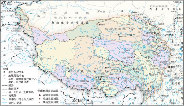
图1
青藏高原城镇化的空间范围
注:该图由中煤地西安地图制印有限公司根据国家公开出版的GS(2020)4325号标准地图制作,
Fig. 1
Spatial range of urbanization in the Qinghai-Tibet Plateau
2 青藏高原城镇化的特殊战略地位、特殊使命与特殊驱动过程
2.1 高原城镇化的特殊战略地位
从在全球可持续发展与人类命运共同体建设中的战略地位分析,青藏高原是“世界屋脊”和“地球第三极”,也是全球生态文明建设高地。既是全球可持续发展的重要组成部分,也是构建人类命运共同体的重要源地,其可持续发展状态表征着全球可持续发展能力与质量。而高原可持续发展能力在很大程度上取决于城镇化发展质量,高原城镇化可持续发展能力直接影响着全球可持续发展和人类命运共同体建设,也决定着全球生态文明建设和中华民族共同体建设。
从在全国城镇化轴线格局中的特殊战略地位分析,青藏高原城镇化地处中国“两横三纵十九群”的新型城镇化战略格局的外围地带[18],虽然不是国家新型城镇化的空间主体区,但因青藏高原城镇化肩负着捍卫国家安全屏障与护卫国家生态安全屏障及“亚洲水塔”的特殊使命,因而在全国城镇化战略格局具有十分重要而特殊的战略地位,对守护好世界上最后一方净土、建设美丽的青藏高原,让青藏高原各族群众生活更加幸福安康、使青藏高原生态安全屏障更牢固、使国家安全屏障更坚固都发挥着不可替代的重要作用。
2.2 高原城镇化的国家战略需求
城镇化是青藏高原最强烈的人类活动过程,也是高原同全国同步实现基本现代化的必由之路。2021年6—7月习近平总书记先后视察青海、西藏时多次强调,要抓好稳定、发展、生态、强边四件大事,在推动青藏高原生态保护和可持续发展上不断取得新成就,奋力谱写雪域高原长治久安和高质量发展新篇章。要坚定不移走生态优先、绿色发展之路,努力建设人与自然和谐共生的现代化,切实保护好地球第三极生态。可见,在青藏高原推进城镇化绿色发展,就是深入贯彻落实习近平总书记“守护好世界上最后一方净土,建设美丽的青藏高原,让青藏高原各族群众生活更加幸福安康”重要指示精神,把高原绿色发展和高质量发展之路贯穿到城镇化全过程和城市建设始终的具体行动。通过城镇化绿色发展,肩负起护卫国家安全屏障、保护国家生态安全屏障、保护“亚洲水塔”避免失稳失衡、传承中华民族传统文化的特殊使命,这种特殊使命决定了青藏高原新型城镇化的战略地位特殊而重要,对建设好“两屏四基地”(国家重要的安全屏障、重要的生态安全屏障、重要的战略资源储备基地、重要的高原特色农产品基地、重要的中华民族特色文化保护地和重要的世界旅游目的地)、守护好世界上最后一方净土发挥着十分重要的作用,城镇化使高原人民生活得更美好,使高原生态安全屏障更牢固,使固边能力更坚固。因而有着与内地截然不同的特殊驱动过程和道路[22]。
2.3 高原城镇化发展的特殊使命
青藏高原城镇化发展的特殊使命在于:是护卫国家安全屏障的固边型城镇化,是保护国家生态安全屏障的绿色城镇化,是保护“亚洲水塔”避免失稳失衡的护塔型城镇化,是传承中华民族传统文化的文化型城镇化,是确保高原人民同全国一道基本实现现代化的新型城镇化。这种特殊使命决定了青藏高原新型城镇化的特殊驱动过程、特殊发展道路、特殊发展目标和特殊发展模式。青藏高原绿色城镇化发展的特殊目标为:稳妥进入城镇化发展的中期阶段并将长期稳定在中期阶段,全面提升城镇化发展质量,城镇化使高原人民生活得更美好,使青藏高原生态安全屏障更牢固,使守边固边能力更坚固。
2.4 高原城镇化发展的特殊驱动过程与特征
青藏高原城镇化过程有着与内地截然不同的特殊自然要素驱动过程、特殊的经济要素驱动过程、特殊的社会文化要素驱动过程和特殊的政策要素驱动过程(图2),是一个在高寒缺氧环境下,由单一投资拉动、游客带动、服务驱动、对口支援等共同发力形成的低度开发型、社会包容型、文化传承型和守土固边型城镇化,理论上是低速高质的绿色城镇化过程。这种特殊的城镇化过程表现为对青藏高原高寒缺氧脆弱生态环境的主动适应过程、护卫水塔过程、守土固边过程、服务驱动过程、客人带动过程、内资拉动过程、渐进渐变过程、小聚大散过程、民族融合过程、文化传承过程、对口结对过程和生态富民过程等特殊驱动过程。在这些特殊驱动要素作用下,青藏高原城镇化进程表现为如下特征:
图2
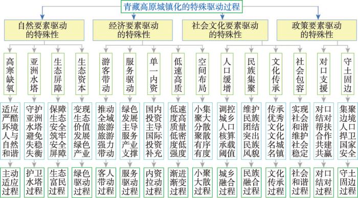
图2
青藏高原城镇化的特殊驱动过程框架
Fig. 2
Framework of special driving process of urbanization in the Qinghai-Tibet Plateau
2.4.1 高原城镇化水平较低,处在城镇化中期阶段
1953—2020年的67年时间里,青藏高原常住人口缓慢增长,由1953年第一次人口普查的454.38万人增加到2020年第七次人口普查的1313.40万人,平均每年新增常住人口12.82万人。1982—2020年的38年时间里,高原常住城镇人口由126.51万人增加到624.79万人,每年新增城镇人口约13.11万人(表1)。常住人口城镇化水平由1982年的15%增加到2020年的47.58%(图3),比2020年全国城镇化水平低16.22个百分点。高原城镇化率每年新增约0.86个百分点,低于同期全国城镇化水平年均增长速度(1.15个百分点)。按照城镇化发展的“S”型增长曲线判断,青藏高原已进入城镇化中期发展阶段,但青藏高原人口城镇化水平始终低于同期全国平均水平,2020年人口城镇化水平比同期全国平均水平低16.22个百分点,这在一定程度上具有合理性。
表1 1982—2020年青藏高原人口与城镇化指标变化表
Tab. 1
| 年份 | 1982年 | 1990年 | 2000年 | 2010年 | 2020年 | 历年平均增长速度(%) |
|---|---|---|---|---|---|---|
| 城镇数量(个) | 86 | 108 | 212 | 350 | 493 | 4.70 |
| 常住人口(万人) | 843.42 | 959.30 | 1066.94 | 1224.31 | 1313.41 | 1.17 |
| 常住人口占全国比重(%) | 0.82 | 0.83 | 0.82 | 0.89 | 0.91 | 0.27 |
| 相对于上一个普查期的 人口年均增长率(%) | 2.83 | 1.62 | 1.07 | 1.39 | 0.70 | -3.61 |
| 城镇人口(万人) | 126.22 | 181.91 | 255.18 | 406.78 | 624.98 | 4.30 |
| 城镇化率(%) | 15.00 | 18.96 | 23.92 | 33.23 | 47.58 | 3.08 |
| 人口密度(人/km2) | 3.82 | 4.35 | 4.84 | 5.55 | 5.95 | 1.17 |
图3
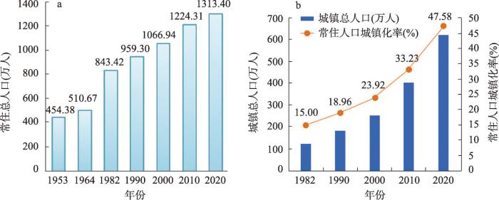
图3
1953—2020年青藏高原常住总人口与城镇化水平变化
Fig. 3
Changes of total resident population and urbanization level in the Qinghai-Tibet Plateau between 1953 and 2020
2.4.2 高原城镇数量少规模小,空间分布极不均衡
1990—2020年间青藏高原城镇数量从108个增加到493个,其中城市数量由9个增加至17个,建制镇数量由99个增加至476个。人口小于1万人的城镇始终占很大比重,城镇人口规模普遍较小,辐射带动能力不足。将1990—2020年青藏高原城镇人口规模等级分为6个级别可知:小于1万人的城镇数量由89个增加到416个,占高原城镇数的比重由82.41%变为84.38%;1万~5万人的城镇数由14个增加到67个,占比由12.96%变为13.59%;5万~10万人的城镇数由3个增加到5个,占比由2.78%变为1.01%;10万~20万人的城镇数由1个增加到2个,占比由0.93%变为0.41%;20万~50万人的城镇数由0个增加到2个(拉萨市区和海东市区),占比为0.41%;大于50万人的城镇数为1个(西宁市区),占比为0.41%。总体来看,高原城镇人口规模普遍较小、辐射带动能力不足已成为青藏高原社会经济发展面临的重要制约因素。受地理环境、社会经济发展基础等因素限制,青藏高原大部分城镇居民点分布分散,人口和产业集聚功能弱,长期达不到建制镇设置标准和设市标准,因此城镇数量少,城镇密度低,城镇数量分布在空间上总体呈现出西北稀疏、东南密集的不均衡格局。
2.4.3 高原城镇职能结构单一,内生发展动力不足
受青藏高原城镇数量少规模小的影响,城镇职能单一且辐射能力差,城镇基础设施建设滞后;城镇化发展主要靠外部“输血”推动,内生经济动力严重不足,高原生态服务潜力巨大,但生态价值难以转化,产业支撑能力不足,2020年西藏和青海GDP分别为1902.74亿元和3005.92亿元,分别位列31个省、自治区和直辖市倒数第1位和倒数第2位,人均GDP分别为54277元和49454元,大大低于全国平均值72568元;边境地区人口急剧下降,边境城镇带建设严重滞后,固边型城镇体系发育缓慢;高原文化重发展轻传承保护,重观光轻体验,重外援轻内生,导致文化名镇特色不突出,自我“造血”功能较弱;城镇集中分布区生态退化,人口分散区生态保护成本高;高原人居环境建设水平低,城镇风貌“雷同现象”明显,公共服务水平和社会服务保障等尚存在不足;作为青藏高原城镇化重点地区的西宁都市圈、拉萨城市圈和柴达木城镇圈同城化程度低,辐射带动作用弱。
3 青藏高原城镇化发展的特殊思路与空间格局
3.1 高原城镇化绿色发展的特殊道路
青藏高原城镇化绿色发展的特殊道路为,走以守土固边为先导、以绿色发展为主导、以通道建设为保障、以文化传承为特色、以人居环境改善为重点的绿色城镇化之路。这种特殊之路是高原人民同全国一道基本实现现代化的必由之路。这种特殊之路要求全面贯彻习近平总书记对西藏、青海、四川、云南工作系列重要指示精神和关于涉藏工作的重要论述,紧紧围绕“稳定、发展、生态、强边”四件大事,立足青藏高原所处的新发展阶段,坚定不移走生态优先、绿色发展之路,以推动城镇化绿色发展为主线,构建新发展格局,统筹绿色发展和国家安全,坚持把捍卫国家安全、护卫“亚洲水塔”、加强民族团结作为高原城镇化的着眼点和着力点,坚持把改善民生、凝聚人心作为高原经济社会高质量发展的出发点和落脚点,确保国家安全和长治久安,确保高原人民生活水平不断提高,确保高原生态环境良好,确保边防巩固和边境安全,努力建设团结富裕文明和谐美丽的社会主义现代化新高原。
3.2 高原城镇化发展的承载阈值与目标
从土地承载力、水资源承载力、经济承载力、大气环境质量承载力、生态承载力、资源环境综合承载力等视角,采用多模型算法测算青藏高原人口承载力和城镇化水平阈值①(① 方创琳, 等. 青藏高原到底能承载多少人多大城研究报告, 2021.),得出青藏高原常住人口承载阈值约为2620万人左右,尚能新增承载人口1187万人。为守土固疆和确保广域青藏高原有人留守,可容许1500万人进城,与2020年现状城镇人口624.95万人相比,青藏高原未来可新增进城人口约875.1万人。综合考虑青藏高原城镇化的特殊性,结合容许进城的人口规模计算得到青藏高原城镇化率可提升到57.25%,将长期处于城镇化发展的中期阶段,这基本符合青藏高原城镇化发展的客观规律。与2020年现状城镇化率47.58%相比,青藏高原未来可新增城镇化率9.67%。
依据青藏高原城镇化承载阈值,未来高原城镇化将稳妥进入城镇化发展的中期阶段并将长期稳定在中期阶段,全面提升城镇化发展质量,城镇化使高原人民生活得更美好,使青藏高原生态安全屏障更牢固,使守边固边能力更强大。综合考虑青藏高原城镇化的特殊使命和资源及生态环境承载阈值,还将至少确保40%左右的人口长期住在农村,一方面维持农牧民生计和振兴乡村,另一方面当好护边员。2025年高原常住人口将达到1400万人,城镇化率宜控制在49%以内,显著提升城镇化发展质量;2035年高原常住人口达到1600万人,城镇化率宜为52.5%左右,全面提升城镇化绿色发展质量与固边能力;2050年高原常住人口达到1900万人,城镇化率宜为55.26%左右,稳固提升城镇化绿色发展质量和固边强边能力。
3.3 高原城镇化绿色发展的特殊思路
立足青藏高原城镇化与经济社会发展的阶段性特征、自然地理资源条件和边疆少数民族地区等特殊性,突出地域、民族、文化特色建设世界屋脊的城镇化,坚持以人为本、优化布局、生态文明、传承文化的基本原则,坚持以高原人的城镇化为核心,有序推进农牧业转移人口镇民化,构建更加公平的社会保障制度,确保各族群众进一步共享现代文明和改革发展成果,积极稳妥推进符合青藏特点的绿色城镇化。具体思路为:① 保障国家安全,该快则快,需稳则稳,确保边境和农村地区有足量人口。② 聚散有度,小聚大散,宜聚则聚,需散则散,在散聚中形成“星星点灯”的固边型城镇体系格局,突出西宁都市圈、拉萨城市圈、柴达木城镇圈和青藏铁路沿线、川藏铁路沿线、唐蕃古道沿线、边境线“三圈四带”的集聚效应,未来青藏高原小城镇和乡村散布的人口规模占青藏高原常住人口规模的比重要超过50%以上。③ 住在镇里,牧在乡里,就近落户,就地就业,就近就地镇民化,走宿镇牧乡型城镇化发展之路。④ 突出特色,彰显民风,弘扬文化,重接地气,建设高原美丽城市与城镇。
3.4 高原城镇化绿色发展的空间格局
2020年青藏高原城镇数量为493个,其中城市数17个,建制镇数476个。在建制镇中,其中人口规模小于1万人的城镇数416个,占高原城镇数的比重高达84.38%。高原城市与城镇包括综合服务型、旅游服务型、工矿服务型、农牧服务型、交通物流型、商贸服务型、边境口岸型、城郊经济型等职能类型,城镇所处的区位、交通等位置不同,发挥的专业化职能各不相同。这些城市与城镇通过近70年的发展,现已基本形成了“三圈四带多节点”的固边型城镇化空间结构新格局(图4),其中:“三圈”指西宁都市圈、拉萨城市圈和柴达木城镇圈,“四带”指青藏铁路沿线城镇带、川藏铁路沿线城镇带、唐蕃古道沿线城镇带、边境地区固边城镇带,“多节点”指多个重要城市节点和重要固边城镇,重点包括海东市、日喀则市、昌都市、林芝市、山南市、那曲市、格尔木市、德令哈市、玉树市、茫崖市、同仁市、香格里拉市、康定市、马尔康市和合作市15个节点城市,这些城市为青藏高原区域性中心城市,是带动青藏高原经济社会高质量发展和稳边固边的重要支撑点。
图4
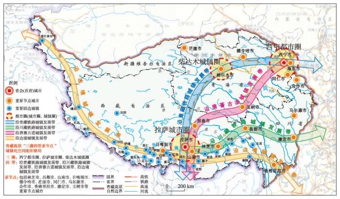
图4
青藏高原“三圈四带多节点”的固边型城镇化空间格局
Fig. 4
Spatial distribution of borderland security urbanization with a pattern of "three circles,
four belts and multi-nodes" in the Qinghai-Tibet Plateau
4 青藏高原城镇化绿色发展路径与对策建议
4.1 高原城镇化绿色发展路径
立足青藏高原城镇化的特殊地位、特殊使命和特殊道路,需要采取守土固边型、绿色驱动型、护卫水塔型、传承文化型、游客拉动型、宿镇牧乡型、生态富民型、小聚大散型、对口结对型、城乡融合型城镇化发展路径(图5)。
图5
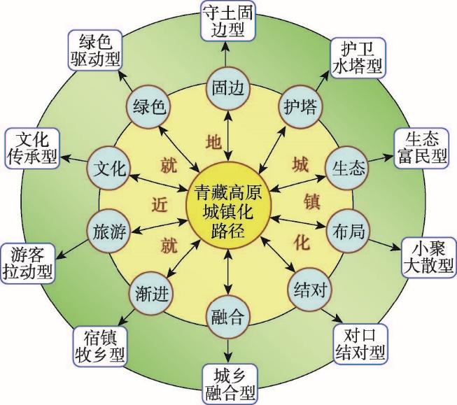
图5
青藏高原城镇化绿色发展路径框架
Fig. 5
Framework of green development path of
urbanization in the Qinghai-Tibet Plateau
(1)守土固边型城镇化路径。以守土固边为先导,加强边境口岸和抵边城镇建设,优化升级边境交通,构建青藏高原“梳状”固边型镇村体系,建设固边戍边的特色镇村;大力发展高原边境生态旅游,确保边境地区适量的旅游活动人口固边;引导本地户籍人口常驻和回流固边,走守土固边型城镇化之路。
(2)绿色生态型城镇化路径。以绿色发展为主导,构建绿色城乡融合发展体系,不断提高生态产品和生态服务能力及水平,将生态价值视为青藏高原高质量发展的核心价值,推动城镇化与生态环境协调发展,探索符合高原特色的生态城镇化模式,改善青藏高原特色人居环境,补齐人居环境建设短板,创建高原公园城市,把青藏高原建成生态富民先行地,建成一批生态富民示范市和示范镇。推动青藏高原从“输血”向“造血”转变;编制青藏高原绿色现代化规划,把高原城市和重点城镇建成高原绿色现代化先行示范区。
(3)低速高质型城镇化路径。以人的城镇化为核心,按保障国家安全和生态安全屏障要求将高原城镇化水平与速度控制在合理水平;把小城镇作为高原就近就地镇民化主体,推进以县城和小城镇为主导的农牧民就近就地镇民化,不断提高城镇化发展质量;重点沿边、沿交通线、沿江建设“小而美、小而精、小而特”的城镇链和固边链,确保乡村地区和边境地区有足够数量的人口守边固边。
(4)文化传承型城镇化路径。以文化传承为特色,加大高原历史文化名城名镇保护与传承力度,编制高原历史文化名城名镇保护规划,完善历史文化城镇保护体系,加大高原历史文化名城名镇保护与建设资金、人才、技术保障力度,走文化城镇化之路。
(5)重点都市圈同城化路径。以重点突破为抓手,加快西宁都市圈、拉萨城市圈和柴达木城镇圈同城化进程,建成高质量都市圈和高品质生活圈。推动西宁—海东一体化发展,建成青藏高原最大最强最优都市圈;推动拉萨—山南一体化进程,建成青藏高原最具文化魅力的城市圈;加快柴达木城镇圈绿色工业一体化与循环经济发展进程,建成国家可再生能源示范区。
4.2 高原城镇化绿色发展对策
(1)超前建设青藏高铁等基础设施,筑牢国家安全保障线。以通道建设为保障,分期分段新建青藏高速铁路;微调川藏铁路选线选站,加密沿线配套交通设施,带动拉萨城市圈建设,完善青藏高原立体综合交通运输通道,融入西部陆海新通道,加密高原机场和航空航线的覆盖度,提高抵边城镇交通通达度,建设好青藏高原综合交通枢纽城市和城镇,筑牢国家安全战略保障线、稳疆固藏战略通道线和战时投送能力应急保障线。
(2)加快引进“新基建”上高原,建设高原智慧城市。依靠科技创新驱动,加快新型数字基础设施建设,建设国家大数据中心、超算中心、战略性资源数据备份中心和大数据交易中心,创建青藏高原大数据产业园,大力发展数字经济和智慧城市。推进“感知青藏”建设,促进物联网在生态环境、应急救灾、高原特色农牧业、智慧旅游等领域的实际应用。
(3)适时调优高原行政区划,加强边境地区设市建镇。从保障国家安全角度,稳妥优化青藏高原边境地区行政区划设置,适时优先建设察隅市、格尔木市、阿里地区3个地级市,适时推进拉萨市林周县、林芝市米林县2县撤县设区,推进青海省大柴旦行委撤委建市、西藏墨竹工卡县、定日县,青海共和县、玛沁县、海晏县、贵德县、囊谦县、都兰县、门源回族自治县、民和回族自治县、互助土族自治县等12个县撤县设市,建成稳疆固边的“新门户”。将定日县改为珠穆朗玛市,推进符合条件的乡改镇和乡改街道。
(4)加快美丽青藏与美丽城市建设进程,提升公众满意度。牢固树立绿水青山就是金山银山、冰天雪地也是金山银山的理念,正确处理好生态保护与富民利民关系,按照美丽中国建设目标,加快美丽青藏、高原美丽城市和美丽城镇建设,筑牢国家重要的生态安全屏障,提升青藏人民对美丽中国和美丽青藏建设的公众满意度。
(5)加快边境城市土地制度改革,建设边境土地改革试验特区。在坚持宪法规定土地公有制前提下,设立边境城市(镇)土地制度改革试验特区,授予边境居民、驻边企业、单位等长期稳定、权益充分、流转顺畅的土地权利,使其守土有责、守土有得、守土有为。以边民为本,设置边境土地制度改革试验特区,因边制宜地实施特殊土地政策[23-24];以土地为根守土有责,授予边民土地永久使用权和承包权,让边民“守者有其地”;以收益为保障守土有得,授予边民土地经营的永久收益权,使边民“护者有其利”;以固边为宗旨守土有为,推进集体经营性建设用地盘活利用和入市流转增值增效;以国土安全为重,在国家重大战略布局和国土空间规划中优先考虑边境城市。
5 结论与讨论
(1)号称“世界屋脊”的青藏高原作为国家安全屏障与国家生态安全屏障,要不要走城镇化发展之路?是学术界一直充满争议的科学命题。通过本文研究肯定地认为,青藏高原城镇化主体位于中国城镇化分区格局中的民族自治地区城镇化发展区和连片扶贫区城镇化发展区,是全国新型城镇化空间格局不可或缺的重要组成部分,是高原同全国同步实现基本现代化的必由之路。加快高原城镇化绿色发展,提升高原城镇化发展质量,对构建人类命运共同体、推进民族地区城镇化融入国家新型城镇化发展大格局、选择具有中国特色与青藏高原特点的城镇化绿色发展之路,对守护好世界上最后一方净土、探索美丽青藏建设之道、保障边疆民族地区社会稳定及长治久安,进一步对构建青藏高原固边型城镇体系,优化国家城镇化战略布局都有着不可替代的重要作用,做着不可估量的特殊贡献。
(2)青藏高原城镇化发展肩负着守护国家安全屏障、保护国家生态安全屏障、护卫“亚洲水塔”避免失稳失衡、传承中华民族传统文化、确保高原人民同全国一道基本实现现代化和构建人类命运共同体的多重特殊使命。这种特殊使命决定了青藏高原城镇化进程有着与内地截然不同的特殊驱动过程,是一个在高寒缺氧环境下,由单一投资拉动、游客带动、服务驱动、对口支援等特殊驱动形成的低度开发型、文化传承型、守土固边型、护卫水塔型、小聚大散型、社会包容型、生态富民型城镇化过程。
(3)青藏高原城镇化发展始终要以守土固边为先导,保障国家安全,快稳有度,确保边境和农村地区有足量人口,全面提升城镇化发展质量;以绿色发展为主导,不断提高生态产品和生态服务能力及水平,突出特色,彰显民风,弘扬文化,住在镇里,牧在乡里,就近就地镇民化,建设高原美丽城市与城镇;以小聚大散为布局原则,聚散有度,在散聚中形成由“三圈四带多节点”构成“星星点灯”式固边型城镇空间格局,突出“三圈”(西宁都市圈、拉萨城市圈和柴达木城镇圈)、“四带”(青藏铁路沿线城镇带、川藏铁路沿线城镇带、唐蕃古道沿线城镇带、边境地区固边城镇带)和“多节点”(多个重要城市节点和重要固边城镇)的集聚效应;以通道建设为保障,超前建设青藏高铁等基础设施,筑牢国家安全保障线,加快引进“新基建”上高原,建设高原智慧城市;以国土安全为重,在国家重大战略布局和国土空间规划中优先考虑边境城市。
(4)青藏高原严酷而脆弱的自然环境决定了在青藏高原可允许承载的常住人口规模和城镇人口规模是十分有限的。较小的承载阈值决定了在高原不可能大规模推进城镇化发展,更没有必要大幅度提升高原城镇化水平,高原城镇化进程不符合城镇化发展的阶段性规律。城镇化发展速度与规模以守土固边、护卫水塔、传承文化和绿色发展为前提,城镇发展质量提升以使高原人民生活得更美好、使青藏高原生态安全屏障更牢固、使守边固边能力更坚固为宗旨。需要说明的是,青藏高原到底能承载多少人口,到底能容许多少人进城才不至于对高原生态环境造成负面影响?对于这一科学问题的探索尽管做了初步尝试并给出初步结论,但仍是未来需要进一步研究的重要方向。
致谢
本文在实地调研、讨论、写作及修改过程中得到杨永春教授、张海峰教授、鲍超研究员、王振波副研究员、马海涛副研究员、李广东副研究员、戚伟副研究员、孙思奥副研究员、范育鹏副研究员等提出了宝贵修改意见,郭晓敏博士、廖霞博士协助收集了相关资料并整理了部分文献,在此一并表示诚挚的感谢。
参考文献
The processes of prehistoric human activities in the Tibetan Plateau: Occupation, adaptation and permanent settlement
DOI:10.13249/j.cnki.sgs.2022.01.001
[本文引用: 1]

The history of human activities on the Tibetan Plateau is crucial for understanding human adaptation to the extreme environment of cold and hypoxia. This paper systematically reviews the archaeological discoveries and studies in recent years, and provides an overview of five development stages of prehistoric human colonization of the Tibetan Plateau from the known of the earliest occupation until permanent settlement. 1) The Denisovan mandible and mitochondrial deoxyribonucleic acid (mtDNA) found in Baishiya Karst Cave (BKC), 3 280 m above sea level ( a.s.l.), on the northeastern Tibetan Plateau, indicate that the ArchaicHomo sapiens, such as Xiahe Denisovan, may have adapted to the plateau at least 190 thousand years ago (ka) during the late Middle Pleistocene and long-term existed in and around the BKC until the last Glacial period; 2) The Initial Upper Paleolithic assemblages, from excavations at Nwya Devu site (4 600 m a.s.l.), reveal that modern humans began to explore the interior region of the Tibetan Plateau as early as 40-30 ka; 3) The relatively rich microlithic sites on the plateau from last deglaciation to early-mid Holocene, show the frequent activities of microlithic hunt-gatherers during this period, especially during 0.9-0.6 ka, perhaps the results of climate warming; 4) According to the evidence of plant remains from the Neolithic sites, millet farmers have entered low-elevation regions (< 2 500 m a.s.l.) on eastern Tibetan Plateau at least 5.2 ka, and permanently settled in regions at elevation above 3 000 m a.s.l. on eastern Tibetan Plateau since 4.8 ka; 5) After 3.5 ka, the introduction and development of wheat and pastoral economy facilitated permanent human occupation in the high-altitude regions (> 3000 m a.s.l.) of the Tibetan Plateau, which is a consequence of cultural exchange in prehistoric Eurasia. These reflect the long-term physiological and cultural adaptation of prehistoric humans in the process of spreading and settling on the plateau. However, our understanding of prehistoric human activities on the plateau is still limited by the number of archaeological sites and excavated materials. Therefore, we suggest that future work should be focused on seeking more prehistoric sites, conducting the systematic study, and solving the following issues: the spatial and temporal distribution of prehistoric hunter-gatherers, farmers and herders on the plateau, their biological and behavioural adaptation to high-altitude environment and connection with prehistoric low-altitude population and modern Tibetans, and the formation and universality of alpine civilization. We expect that new discoveries and multidisciplinary endeavours will promote the understanding of these issues in the future.
史前人类探索、适应和定居青藏高原的历程及其阶段性讨论
DOI:10.13249/j.cnki.sgs.2022.01.001
[本文引用: 1]
系统梳理了近年来的考古发现与研究成果,总结出人类向青藏高原扩散直至定居的5个阶段性发展过程:古老型智人自中更新世晚期就开始了对高原的适应;现代智人于40~30 ka前已经开启了对高原腹地的探索;末次冰消期以来的气候转暖时段,细石器人群向高原大范围扩散,并在全新世早中期的活动更为频繁;粟作农业人群至少在5.2 ka前进入高原东部低海拔的河谷地带,在4.8 ka以后开始定居在高原东部3 000 m以上海拔的区域;3.5 ka以来麦作的传入和牧业经济的发展助力人群大规模定居高海拔区域。人类在向高原扩散和定居的过程中经历了漫长的生理与文化适应,但受限于当前考古发现与研究材料,史前狩猎采集、农业和牧业等人群在高原的时空分布、对高海拔环境的生理与行为适应﹑与低海拔人群和以藏族为主的现代高原人群之间的联系,以及高寒地区河谷农业和山地高原面游牧双重经济活动对高寒文明形成的支撑作用和高寒文明的普适性等问题仍需要深入研究,期待未来多学科交叉融合共同推动对这些问题的理解。
Regional differentiation of population in Tibetan Plateau: Insight from the "Hu Line"
DOI:10.11821/dlxb202002004
[本文引用: 1]
The Tibetan Plateau is regarded as a typically sparsely populated area both from Chinese and global perspectives. There exists a large difference in population distribution of the Tibetan Plateau. Based on the town-level census data in 2010, we compiled a spatial population database to calculate the population density of the Tibetan Plateau. We found that the population distribution on this plateau was characterized in four dimensions, namely longitude, latitude, polarization and altitude. In addition, similar to the "Hu Line" for Chinese population distribution, we introduce the "Qilian-Gyirong Line" (short for Qi-Ji Line), a spatial division line of population geography in the Tibetan Plateau. Our main results are summarized as follows. (1) There are significant regional differences in the spatial population distribution in the Tibetan Plateau. The population density in the southeast was higher than that in the northwest. Compared to longitude-oriented, latitude-oriented and altitude-oriented regional differences, the polarization-oriented regional difference of population distribution was more prominent. This finding indicates that fewer people live in areas close to the cold-arid core of the Tibetan Plateau. (2) The spatial population distribution is closely related to the natural and environmental factors, including altitude, soil, water resources, climate and vegetation. The interaction between the natural factors has an impact on enhancing the regional difference of population. (3) The "Qiji Line" reveals the spatial differences of population in the Tibetan Plateau. The areas on either side of the line are approximately similar, whereas the population shares in the southeast and northwest halves are 93% and 7%, respectively. (4) In general, the population differences on both sides of the "Qiji Line" were stable over time. During 1982-2010 the population share in the southeast half decreased counterbalanced by an increased share in the northeast half. In the future, the majority of the people are expected to live on the southeast side. This is likely to imply two major policy initiatives. More attention is required on the urbanization development and transportation network construction in the southeast half and the increasing eco-environmental pressures from the growing population in the northwest half.
青藏高原人口地域分异规律及“胡焕庸线”思想应用
DOI:10.11821/dlxb202002004
[本文引用: 1]
青藏高原是中国乃至全球典型的人口稀疏区之一,但内部人口地域分异明显。通过构建青藏高原乡镇街道尺度的人口空间数据集,系统核算青藏高原人口数量及其空间密度,从经度、纬度、极向和垂直4个维度解析青藏高原人口地域分异规律,并基于“胡焕庸线”思想,提出青藏高原的“祁吉线”人口地理划分方案。结论包括:① 青藏高原人口空间分布不均衡,具有“东南密、西北疏”的总体空间分布特征,距离“寒旱核心区”近疏远密的极向地域分异明显;② 青藏高原人口地域分异与海拔、土壤、水资源、气候、植被等自然环境本底具有高度耦合关系,自然因素间交互作用加强了人口地域分异;③ 青藏高原人口地域分异可以通过连接祁连县与吉隆县的“祁吉线”体现,两侧地域面积大致相同,但是东南半壁与西北半壁人口比例达到93∶7的悬殊;④ “祁吉线”长期稳定,但是东南半壁人口持续微降,西北半壁人口持续微增,未来时期,东南半壁依然是青藏高原城镇化及人类活动的主要区域,而西北半壁应当重视人口增长与生态环境压力的矛盾。
The spatial evolution characteristics and driving forces of village and town settlements in the Qinghai-Tibet Plateau
青藏高原地区农村居民点空间演化特征及驱动力研究
Spatiotemporal evolution of the urban system in the Tibetan Plateau
青藏高原城镇体系的时空演变
DOI:10.12082/dqxxkx.2019.180681
[本文引用: 2]
城镇体系的形成和发育对区域城镇化进程及社会经济发展起着至关重要的作用,并对生态环境产生重要影响。青藏高原特殊的地理环境与相对落后的社会经济基础,导致城镇体系不甚健全。目前国内外相关研究薄弱,不利于国家生态安全屏障建设及青藏高原可持续发展。为此,本文以建制镇以上的镇区和城市市区为研究对象,结合统计数据与遥感数据,借助GIS空间分析方法对青藏高原1990-2015年城镇体系的空间结构和规模结构进行时空演变格局分析,并采用重心移动模型揭示了青藏高原城镇人口规模和用地规模重心的迁移规律。结果表明:青藏高原城镇空间分布总体呈现出“东南密集、西北稀疏”、“大分散、小集聚”的格局;城镇分布在时间上具有阶段性增长特征且总体趋于集聚,在空间上不均衡程度呈上升趋势但2005年后明显减缓;虽然建制镇数量大幅增长,但96.88%的城镇规模在5万人以下,大中小城市发育不足;城镇人口规模重心呈现“先向西南,再向东北,又向西南”的移动轨迹;城镇用地规模重心呈现“先向东南,再向西北,再向东北”的迁移趋势。本文研究了青藏高原城镇体系的规模结构及其时空演变特征,为青藏高原新型城镇化及城镇空间格局优化提供基础依据;提出了资料缺乏和统计口径不一致的条件下城镇规模的合理估算方法,对我国城镇化相关研究具有一定的参考价值。
Mapping human influence intensity in the Tibetan Plateau for conservation of ecological service functions
DOI:10.1016/j.ecoser.2017.10.003 URL [本文引用: 1]
Human footprint in Tibet: Assessing the spatial layout and effectiveness of nature reserves
DOI:10.1016/j.scitotenv.2017.11.216 URL [本文引用: 1]
Spatiotemporal pattern of population distribution in the Qinghai-Tibet Plateau during the national day holidays: Based on geospatial big data mining
基于位置大数据的国庆假期青藏高原人群分布时空变化模式挖掘
DOI:10.12082/dqxxkx.2019.190067
[本文引用: 1]
人类活动是引起青藏高原生态环境发生改变的重要因素。很多学者对青藏高原史前人类活动和近几十年的人口分布格局与人口流动开展了大量研究,但有关人群时空分布的精细尺度研究相对缺乏。海量的位置大数据为认识高原人群短期的动态变化提供了新途径。本文利用手机定位数据、人口迁徙数据等高时空分辨率的位置大数据,通过时间序列分解方法和基于统计检验的异常判别方法,分析了2017年国庆期间青海与西藏的人群分布时空变化特征,并探讨了假期旅游行为及人口迁徙与变化特征之间的关系。研究结果显示:① 在省级和城市整体尺度上,定位请求量的假期变化在时间上呈现先降后升的“潮汐”变化模式;② 在精细网格尺度上,西宁和拉萨城市及周边地区的人群分布变化在空间上呈现中心跌、周边涨的“离心化”变化模式。国庆假期人们向城市周边热门景点移动聚集的旅游行为和城市之间的人口迁徙都是导致西宁和拉萨周边地区定位请求量上涨的重要潜在原因,而两座高原城市中心定位请求的下跌不仅与人口迁徙有关,还与假期人类日常行为及定位请求频次的变化等因素有关。通过位置大数据挖掘节庆假期人群分布的时空变化,不仅加深了对高原人口分布格局与流动变化的认识,也为高原城镇化与生态保护的精细化管理与决策提供支撑。
Discovering spatio-temporal patterns of human activity on the Qinghai-Tibet Plateau based on crowdsourcing positioning data
DOI:10.11821/dlxb202007006
[本文引用: 1]
The activities of local people and tourists have great effects on the ecological environment on the Qinghai-Tibet Plateau. Different kinds of activities may cause different impacts on ecology and environment. To effectively protect the ecological environment, it is necessary to study the spatiotemporal patterns of different kinds of human activities. In this paper, two Tencent positioning datasets which record one-week location requests in January and July of 2018, respectively, are used to explore the human activities in off-season and peak season of tourism on the plateau. A Tucker tensor decomposition method is employed to reduce the dimension of massive data and obtain the principle modes of human activities. The data in off-season are decomposed into 3 daily patterns, 3 hourly patterns and 8 spatial patterns, and the data in peak season are decomposed into 2 daily patterns, 4 hourly patterns and 8 spatial patterns. By analyzing the core tensor, different kinds of activities are inferred through the relations among different dimensions of data, and the human activities in off-season and peak season of tourism are analyzed. The human activities on the Qinghai-Tibet Plateau are found to be different from those in other places. Different from ordinary weekday and weekend patterns, there is a mid-week pattern (Tuesday through Friday) and an inter-week pattern (Saturday, Sunday and Monday) on the Qinghai-Tibet Plateau, and there is a special holiday pattern in off-season of tourism. It is also found that the human activities in off-season and peak season of tourism are different, which indicates different activities of the local residents and the tourists. In off-season of tourism, the positioning activities are very active in the morning, however, the activities are less active during the daytime of mid-week days than during the daytime of inter-week days, and the activities are mostly found in the cities in the mid-week days but mostly in the outskirts of the cities or on the way to scenic spots in the inter-week days. In off-season, there exist the activities of local residents. In peak season, there are less activities in the morning, but the activities during the day are more broadly distributed both in the mid-week days and in the inter-week days. It is indicated that the activities of tourists are significant in the peak season. After clustering spatial grids with similar patterns, we find that there are mixed spatial patterns in most parts of the study area, which discloses that there are usually multiple kinds of human activities in a region.
基于位置大数据的青藏高原人类活动时空模式
DOI:10.11821/dlxb202007006
[本文引用: 1]
随着青藏高原城镇化和旅游的发展,人类活动强度不断加剧,有必要对青藏高原不同类型的人类活动时空模式进行研究,以便了解不同区域人类活动对自然环境的影响以及更好地采取生态环境保护措施。利用腾讯位置大数据,分析青藏高原在旅游淡季和旅游旺季的人类活动时空模式,研究旅游人口对青藏高原人类活动的影响。本文分别选取2018年1月和7月的腾讯定位请求数据,构建多时空维度的高阶张量,采用张量分解的方法对数据进行降维,获取旅游淡季和旺季不同时空维度的主要特征,分析活动模式,发现青藏高原在旅游淡季和旺季的活动模式在时间上和空间上都有很大不同,体现了旅游人口造成的影响。在旅游淡季,青藏高原居民的活动在凌晨有个高峰,在午间有个低谷,并且表现有特殊的节日模式,工作日的人类活动主要分布在城镇等人口聚集区,休息日向城镇周边发散;旺季凌晨活动分为两个高峰,一个在时间上较淡季提前,与午夜活动相连,另一个较淡季的时间推迟,旺季活动没有午间的低谷和特殊的节日模式,且工作日和休息日的日间活动都分布较广。
An analysis of urbanization and its dynamical mechanism in Qinghai-Tibet Plateau
青藏高原城镇化及其动力机制分析
Spatio-temporal pattern and drivers of the population urbanization in the Tibetan Plateau
青藏高原城镇化格局的时空分异特征及影响因素
The settlement intention of floating population and the factors in Qinghai-Tibet Plateau: An analysis from the perspective of short-distance and long-distance migrants
DOI:10.11821/dlxb202109008
[本文引用: 2]
The floating population has become an important driving force of population growth in the Qinghai-Tibet Plateau in recent years, and thus the settlement intention of the floating population is of vital importance to the sustainable urbanization of the Qinghai-Tibet Plateau. Based on the data of China's floating population dynamic monitoring survey in 2017, this paper measured the settlement intention of the floating population in the study area, and according to their migration source of Qinghai-Tibet Plateau area, and distinguished the short- and long-distance floating population, and then compared their settlement intentions. Following this, we built a multi-level logistic regression model to analyze the underlying driving forces of the settlement intentions of the floating population as well as the possible differences between the short- and long-distance floating population. The main findings are as follows: (1) The overall settlement intention of the floating population in the plateau area was not high, and only about 32% of the floating population intend to stay in the urban areas for a long time; except for Lhasa, Xining and Haixi, that proportion is only about 10% of the prefecture units. (2) The settlement intention of the short-distance floating population was significantly higher than that of the long-distance floating population, but the percentages of the short-distance floating population with long-term settlement intention in most prefecture units were still less than 20%. (3) Education level, income level, urban medical insurance, social integration, economic development level and natural conditions of the inflow destinations have significant influence on the settlement intention of the floating population. (4) The difference of settlement intention between short- and long-distance floating population was closely related to the migration motivation and the social integration. Based on the above findings, this paper suggests that it is necessary to take targeted measures to improve the settlement intention of the short- and long-distance floating population in terms of the influencing factors, and also explore the suitable urbanization pattern for the Qinghai-Tibet Plateau area, such as promoting the local urbanization.
青藏高原流动人口居留意愿及影响因素
DOI:10.11821/dlxb202109008
[本文引用: 2]
流动人口是青藏高原人口增长的重要动力,其城镇居留意愿关乎青藏高原城镇化的可持续发展。利用2017年中国流动人口动态监测调查数据,测算青藏高原流动人口城镇居留意愿,根据来源地是否在青藏高原地域范围内,划分近程和远程流动人口,解析近程和远程流动人口城镇居留意愿的分异特征,建立多层Logistic回归模型,探讨流动人口城镇居留意愿及其近远程分异的影响因素。主要发现如下:① 青藏高原流动人口总体城镇居留意愿不高,仅有约32%的流动人口打算在城镇地区长期居留;除拉萨、西宁和海西等少数地区外,多数地区该比例仅约为10%。② 近程流动人口城镇居留意愿明显高于远程流动人口,但近程流动人口在多数地区的居留意愿仍低于20%。③ 受教育程度、收入水平、城镇医疗保险、社会融合程度以及流入地的经济发展水平、自然条件等因素对流动人口城镇居留意愿具有显著正向影响。④ 近程和远程流动人口城镇居留意愿分异与流动原因、社会融合程度等方面的差异密切相关。最后,针对青藏高原的特殊性,提出差异化的流动人口高质量城镇化政策建议。
Human development assessment and evolution analysis on the Qinghai-Tibet Plateau
DOI:10.13249/j.cnki.sgs.2021.06.018
[本文引用: 1]
Through specific analysis of the three dimensions of night light development index (NLDI), cultural diversity and the rank-size rule, the human development level of the Qinghai-Tibet Plateau in different periods is evaluated. The results show that: 1) Since the 21st century, human development in the Qinghai-Tibetan Plateau has been improved year by year, but the overall level of human development is still below average level. There are some spatial differences in the level of human development within the region. The night light intensity in the southeast is relatively high, showing the concentrated population distribution. 2) The areas with high ethnic diversity in the Qinghai-Tibetan Plateau mainly extend and expand along the Tibetan-Yi Corridor and Hexi Corridor. The night light intensity in the multicultural blending area is high, and the overall level of human development is on the rise. 3) The rank-size rule is used to analyze the urban scale constructed by night light intensity. A prominent problem in the urban system of the Qinghai-Tibet Plateau lies is that the maximum urban scale is still too small.
青藏高原地区人类发展水平评估及其演变分析
DOI:10.13249/j.cnki.sgs.2021.06.018
[本文引用: 1]
通过夜光发展指数(NLDI)、文化多样性和城市位序规模法则3个维度进行分析,评估不同时期青藏高原地区的人类发展水平。研究表明:① 21世纪以来,青藏高原地区人类发展水平在逐年提升,但是人类发展水平整体上还处于中等偏下水平,区域内部人类发展水平存在一定的空间差异,东南部夜间灯光强度比较高,人口分布集中;② 青藏高原民族多样性较高区域主要沿着藏彝走廊和河西走廊延伸和扩展,多元文化交融地区的夜间灯光强度高,人类发展水平总体呈上升趋势;③ 采用位序规模法则分析由夜光强度构建的城市规模,最大城市规模太小仍然是青藏高原地区城镇体系的突出问题。
Systematically addressing the heterogeneity in the response of ecosystem services to agricultural modernization, industrialization and urbanization in the Qinghai-Tibetan Plateau from 2000 to 2018
Environmental stress intensity of human activities and its spatial effects in the Qinghai-Tibet Plateau national park cluster: A case study in Sanjiangyuan region
青藏高原国家公园群区域人类活动环境胁迫强度与空间效应: 以三江源地区为例
Interaction between urbanization and eco-environment in Tibetan Plateau
DOI:10.11821/dlxb202007005
[本文引用: 1]
Scientifically assessing the interaction between urbanization and eco-environment in the Tibetan Plateau is critical for optimization of urbanization speed and quality, and for the restoration and improvement of the eco-environment. Based on previous studies about the interaction between urbanization and eco-environment in the Tibetan Plateau, we established complete analysis models to examine the overall process, including comprehensive evaluation index analysis, coupling coordination degree measurement, coupling type identification, decoupling path exploration, and future trend prediction. We used a multi-scale comparison analysis method to clarify the differences between scales (across the Tibetan Plateau and its provinces and prefecture-level cities), identify the problem regions, and propose customized improvement measures. Here we show that the comprehensive evaluation index of urbanization has experienced a staged upward trend in different scales, and the overall urbanization index of Qinghai is higher than that of Tibet. However, the changing trends of the eco-environment index are different. The changes in eco-environment index of Qinghai show a decreasing trend, whereas Tibet's changes tend to be stable. The eco-environment index of prefecture-level cities is stratified. We also found that the changing trends of coupling coordination degree of urbanization and eco-environment in different scales were overall rising. The coupling type has changed from imbalanced recession type to nearly imbalanced recession type, and finally to grudgingly coordinated development type. However, most of these types are lagged urbanization types. The alternate change trend between strong decoupling and weak decoupling indicates a negative interaction between urbanization and the eco-environment at different scales. Thus, it can be inferred that the lagged urbanization is a prominent phenomenon. The result of predication shows that in the next 10 years the coupling coordination degree of urbanization and eco-environment will increase steadily in all geographic units, but there will be a gap in the growth rate.
青藏高原城镇化与生态环境交互影响关系分析
DOI:10.11821/dlxb202007005
[本文引用: 1]
科学评估青藏高原城镇化与生态环境交互影响的总体状况,对优化城镇化速度和质量,修复和提升生态环境状态具有重要意义。在梳理青藏高原城镇化与生态环境交互影响研究进展基础上,本文尝试构建一套完整的城镇化与生态环境交互影响分析模型体系,实现从综合评价指数分析、耦合协调度量化、耦合类型识别、解耦路径探索到未来趋势预测的全过程解析。以青藏高原及其省域、地级单元多尺度分析对比为手段,尝试厘清尺度之间的差异性,识别出问题区域,并提出针对性的改进措施。研究发现,青藏高原不同尺度间城镇化综合评价指数呈阶段性上升趋势,青海的整体城镇化指数高于西藏;生态环境指数变化趋势不同,青海呈下降态势,西藏则趋向平稳,各地级单元生态环境指数存在分层现象。青藏高原不同尺度城镇化与生态环境耦合协调度总体呈上升趋势,协调类型由失调衰退类向濒临失调衰退类转变,最后转为勉强协调发展类,基本属于城镇化滞后型。城镇化指数与生态环境指数呈现出强脱钩、弱脱钩交互出现的波动态势,说明不同尺度间存在城镇化与生态环境的负相互作用,消极城镇化现象突出。通过预测,青藏高原各地级单元在未来10年内,系统耦合协调度将稳步上升,但各地增长速度将存在显著差距。
Emerging water pollution in the world's least disturbed lakes on Qinghai-Tibetan Plateau
Redetermine the region and boundaries of Tibetan Plateau
再论青藏高原范围
DOI:10.11821/dlyj020210138
[本文引用: 1]
伴随青藏高原研究的深入,高原内外多学科研究程度和认识的提高,及地理大数据、地球观测科学和技术的进步,对青藏高原范围提出了新的要求。本研究系统论述了确定青藏高原范围的原则、依据和方法,分析探讨了高原地貌宏观结构(高原面、高原内低盆地与高原边缘河谷低地等)和周围边界各自然地段构成的基本特征。采用ArcMap软件,通过遥感影像和DEM数据及新资料对高原地貌比较研究,实现了1:100万比例尺地图精度的青藏高原范围的界定。研究表明,青藏高原北起西昆仑山-祁连山山脉北麓,南抵喜马拉雅山等山脉南麓,南北最宽达1560 km;西自兴都库什山脉和帕米尔高原西缘,东抵横断山等山脉东缘,东西最长约3360 km;范围为25°59′26″N~40°1′6″N、67°40′37″E~104°40′43″E,总面积为308.34万km<sup>2</sup>,平均海拔约4320 m。在行政区域上,青藏高原分布于中国、印度、巴基斯坦、塔吉克斯坦、阿富汗、尼泊尔、不丹、缅甸、吉尔吉斯斯坦等9个国家。其中中国境内的青藏高原面积约258.09万km<sup>2</sup>(占高原总面积的83.7%),平均海拔约4400 m,分布在西藏、青海、甘肃、四川、云南和新疆等6省区,西藏和青海两省区主体分布在高原范围内(约占高原总面积的60.6%)。
The theoretical cognition of the development law of China's urban agglomeration and academic contribution
DOI:10.11821/dlxb201804005
[本文引用: 1]
Urban agglomeration refers to a highly integrated city and town group. It comes into being with the development of industrialization and urbanization to the advanced stage. The formation and development of urban agglomeration is a long natural process, which is transformed from competition to cooperation. China is in a new stage of urbanization transition, and has entered a new era of leading the global urban agglomeration development in the 21st century. The research and experience model of China's urban agglomeration has been accepted by global urban agglomeration construction as reference. In this paper, the natural law of urban agglomeration is proposed, including developmental gradual law, multi-scale transmission law of space intensive utilization, the combination law of spatial crystal structure, the natural growth of the breeding tree, and the gradient upgrade law of sustainable development. Following these laws, Chinese geographers have made great contributions to the research and development of China's urban agglomerations, which focuses on academic theory, technical method, decision support and planning practice. We developed and scientifically defined the concept of urban agglomeration, and first adopted the identification standard of urban agglomeration space. We established the spatial intensive development and layout simulation decision support technology chain in urban agglomeration, and developed related software chain. We laid out the new pattern of 5+9+6 in the spatial organization of China's urban agglomerations, and formulated the first China's urban agglomeration planning technical regulation. We completed the development plan of most urban agglomerations in China, which has become an important basis for decision-making at the national level. In the future, geographers will play a growing role and shoulder the responsibility in the development of Chinese urban agglomerations. We should combine qualitative and quantitative methods, and use big data and intelligent decision support technology to solve a series of problems in the development of this cause. Only in this way can Chinese geographers make greater contributions to the development of urban agglomerations.
中国城市群形成发育规律的理论认知与地理学贡献
DOI:10.11821/dlxb201804005
[本文引用: 1]
城市群是国家工业化和城镇化发展到高级阶段的产物,是高度一体化和同城化的城市群体,城市群形成发育过程是一个各城市之间由竞争变为竞合的漫长自然过程,遵循自然发展规律。中国正处在新型城镇化转型发展的新阶段,已进入21世纪引领全球城市群发展的新时代,中国城市群研究与建设的经验模式正在被全球城市群建设所效仿和借鉴。本文从理论上梳理并提出了城市群形成发育遵循的自然规律,包括城市群形成发育的阶段性规律、城市群多尺度空间集约利用传导规律、城市群空间晶体结构组合规律、城市群自然生长的育树成林规律和城市群可持续发展的梯度爬升规律。地理学家遵循这些发展规律,从学术理论、技术方法、决策支持和规划实践等方面为中国城市群的研究和发展做出了不可替代的重大贡献,主要包括提出并科学界定了城市群概念,提出了城市群空间范围的识别标准,创建了城市群空间集约拓展与布局仿真决策支持技术链,研制了城市群空间集约拓展与布局仿真决策支持系统软件链,提出了中国城市群空间组织的“5+9+6”新格局,研制出国内第一部《城市群规划技术规程》,编制完成了全国多数城市群发展规划,转化为国家决策的重要依据。未来中国城市群的发展与研究中,地理学家发挥作用的空间越来越大,地理学家肩负着不可推卸的责任使命,应责无旁贷地采用定性与定量相结合的研究方法,引用大数据、智能决策支持技术等新手段解决城市群发展面临的一系列问题,一如既往地为城市群发展吸纳众智、献计献策,发挥更大作用,做出更大贡献。
Analysis of emergy-based metabolic efficiency and environmental pressure on the local coupling and telecoupling between urbanization and the eco-environment in the Beijing-Tianjin-Hebei urban agglomeration
DOI:10.1007/s11430-016-9038-6 URL [本文引用: 1]
A regional categorization for "new-type urbanization" in China
Particularities, gradual patterns and countermeasures of new-type urbanization in Tibet, China
西藏新型城镇化发展的特殊性与渐进模式及对策建议
Spatio-temporal dynamics of the urban-rural construction land and ecological land on Qinghai-Tibet Plateau
青藏高原城乡建设用地和生态用地转移时空格局
DOI:10.12082/dqxxkx.2019.190087
[本文引用: 1]
青藏高原作为中国重要的生态环境保护地,城镇化和生态环境的变化受到广泛关注。本文基于1990-2015年土地利用数据,进行生态用地和城乡建设用地之间的转移分析,通过核密度以及标准差椭圆分析进行空间转移强度的定性研究。结果表明:① 1990-2015年青藏高原生态用地显著地向城乡建设用地转移,是城乡建设用地向生态用地转移量的54.6倍,其中2000-2005年和2010-2015年是用地转移的热点时期;② 城乡建设用地与生态用地之间的转换在空间上呈现逆向状态,生态用地向城乡建设用地的转移分布逐渐从青藏高原的周边区域向腹地蔓延;城乡建设用地向生态用地的转移最初出现在青藏高原的腹地,逐渐向外围扩张;③ 生态服务功能越大的生态用地,越容易被人类占用,随之发生用地类型的转移,侵占后的土地很难反向转移为具有高生态服务功能的生态用地。
