

1 引言
在社会经济加速转型发展中的中国,城市居民对生活质量的追求从基础的物质条件转向更深层次的生活品质。然而,随着城镇化的快速推进,城市人口快速增长,致使城市公共服务失衡,城市义务教育、基础医疗、公共交通、绿色空间等资源供应不足,且在城市内部存在空间供应和结构性差异等问题[1]。“基本公共服务均等化水平明显提高”是中国“十四五”时期经济社会发展主要目标之一,因此,评价及改进城市公共服务设施空间布局、服务质量和公平性具有现实意义。
可达性是评价公共服务公平性的一个重要指标。Hansen于1959首次提出可达性概念,即“网络中各节点相互作用的机会大小”,基于此研究可达性与城市土地利用之间的关系[2]。随着地理空间技术的快速发展,部分学者从空间角度对可达性的概念进行解读,定义“空间可达性”为“基于某种交通方式从一个地方到一个目的地的便捷性”[3,4]或“互动机会的潜力”[5,6]。这一概念逐渐成为衡量公共服务设施公平性的重要依据,被广泛的应用于医疗设施[7,8,9]、公共绿色空间[10,11,12,13,14]、教育设施[15]、交通设施[16,17,18]的公平性和空间布局的研究中[19,20,21,22,23]。目前,空间可达性测度方法主要包括供需比法、最近距离法、重力模型法、累积机会测度和两步移动搜索法(Two-step Floating Catchment Area Method, 2SFCA)等[19,20,21,22,23,24,25,26]。这些方法具有计算简单、使用方便的特点,得到了广泛应用,但是也存在各种不足。例如,供需比指标仅可以反映区域间的公共服务设施可达性的差异[27]。最近距离法假设居民总是选择最近的公共服务设施,忽略设施的服务能力[28]。2SFCA方法较好地考虑了供给和需求,但出行时间或距离阈值的设定对结果影响较大[8, 11, 26]。
因此,本文提出了一个基于最优供需分配的公共设施空间可达性测算方法(Optimal Supply-demand Accessibility Method, OSD),试图取代现有方法。基本思路是:利用优化模型将设施服务分配给需求者,根据分配结果计算空间可达性指标,并与传统的2SFCA可达性计算结果进行对比分析。案例实验表明所提出的可达性计算方法计算效率高,统计指标物理意义明确,适用于公共服务设施的可达性分析与布局优化改进。
2 文献回顾
已有公共服务设施空间可达性分析方法主要包括供需比法、最近距离法、潜力模型法、2SFCA等。供需比法是测度一定地域范围内(如以地级市、县为单元)设施的供给量与需求量的比值[27]。该方法假定,一定地域范围内的设施只服务于该范围内的人,不考虑边界范围以外的人被服务情形。所得的比值越大,说明该地域范围内设施的总体可达性越好。该方法虽然综合考虑了供给方和需求方的量的大小,但无法揭示所研究单元内部可达性的空间差异,而且也无法体现供给双方跨地域单元的相互作用。主要评估大尺度省、市、县之间以及城乡之间的公共服务资源分布差异。
最近距离法是通过计算研究对象到最近设施的距离来测度研究可达性。该方法假设人们总是喜欢访问离自己最近的设施[28]。常用的距离度量包括欧式距离、路网距离和时间距离。其中,欧式距离是研究对象和设施点之间的直线距离。该方法计算比较简单,思路清晰,但是无法反映供应和需求之间的匹配比,也无法反映其他设施点对研究对象的可达性。
2SFCA包括简单2SFCA、增强E2SFCA、可变搜寻区V2SFCA、广义G2SFCA、重力2SFCA等,综合考虑供给和需求,通过设定出行时间或距离阈值,计算特定地点可访问设施(或资源)的数量。阈值内的设施越多,可达性越好。简单2SFCA用二分法来处理距离衰减,仅考虑了阈值范围内的供给点,阈值范围以外的供给点未予以考虑。并假设阈值范围内的供给点,无论距离远近,对需求点的可达性有着同等的影响。之后,部分学者采用出行时间分段赋予权重[31,32]、可变搜寻区[33,34]、核密度函数[35]和高斯函数[36]等来刻画距离衰减问题。重力2SFCA将各种距离衰减函数(幂函数型、指数型和对数型等)引入到2SFCA中[37,38]。2SFCA的问题在于阈值时间或距离设定,以及距离衰减参数β的取值。参数β,阈值时间或距离设定不同,结果差异较大[31-32, 39-40]。
旅行时间/距离是空间可达性计算的关键因子之一。通常受到两个主要因素的影响,一是不同交通模式的选择,二是道路的实际通行速度。传统情况下,距离常采用静态的供给点和需求点间的起止点(Origin-destination, OD)距离来衡量。随着大量开源的交通时空大数据的涌现,部分学者[39,40]结合互联网地图服务平台所公开的实时电子网络地图数据和道路导航数据,利用实时交通时间来代替静态网络距离,更加准确的刻画旅行时间,进而对传统的空间可达性方法进行修订。Rong等[39]发展了基于地图API的潜力模型,刻画居民点和医疗设施点间的实时交通距离,评估郑州市医疗设施空间布局的合理性。王奇[40]以上海市为例,探讨了在互联网地图服务支持下,城市多交通模式和不同交通出行方式下的城市医疗服务的可达性。但是,通常存在与公共服务设施和需求方相关的高质量时空大数据难以获取等方面的问题。
综上,已有模型对于供需关系的表达不够充分。供需比法仅计算一定区域内整体服务供需比,不能反映局部差异。最近距离法考虑距离影响,而不涉及供需。潜力模型法和2SFCA在衡量公共设施空间可达性时,仅考虑局部空间范围内的服务供给和需求,局部空间的大小受时间或距离阈值设定影响很大。现实中,区域内不同区位实际获取服务的距离差异较大,固定时间或距离阈值,难以反映真实服务供需关系。因此,有必要提出一个能充分反映供需关系,且物理意义明确的公共设施可达性计算方法,用于公共服务设施的可达性分析与布局优化改进。
3 最优供需分配模型
本文基于最优供需分配结果计算空间可达性。在一个地理区域内,令集合V ={1, 2, …, m}表示m个需求点,每个需求点上的属性di表示需求量;集合U ={1, 2, …, n}表示n个供给点,每个供给点上的属性qj表示服务供给量;变量cij表示需求点i和供给点j之间的距离。引入决策变量xij表示设施j为需求点i提供的服务量,可构建最优供需分配线性规划模型:
式(1)为目标函数,表示最小化旅行成本;式(2)保证对于任一需求点,到所有供给点访问的需求量等于该点总需求量;式(3)保证每一个设施分配的服务量不超过其供给量。
基于模型求解结果进行空间可达性测算。运输问题模型以最优的方式将设施服务分配给需求者。根据模型计算获得的供需关系,可以灵活地统计公共设施服务指标,并制作各种专题地图。服务指标主要包括:人均使用服务旅行时间、各需求点使用服务旅行时间、各设施使用者的平均旅行时间、特定半径内的服务覆盖率等。这些指标不仅可以评价各区位获取服务的便捷程度,也可以判断设施服务能力是否充足、设施区位是否合理。
应当注意,以上模型假设设施服务能力大于总需求。若这一条件无法满足时,模型无解。针对这一情况,可考虑两种解决方案。一是假设服务设施超负荷运行,按比例调整供给点的服务能力,使服务供应量等于或大于总需求;二是假设部分需求不能得到满足,调整模型求解,模型修订如下:
作者在Python 3.8环境中,开发了基于最优供需分配的公共设施空间可达性计算工具。该工具读取在GIS中准备好的数据,建立案例模型,然后使用开源CBC MIP求解器(
4 案例分析
4.1 案例数据
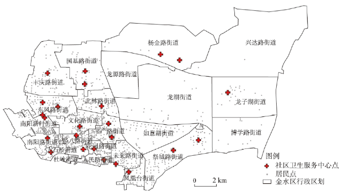
本文以郑州市金水区为例,利用基层社区卫生服务中心和小区尺度人口数据,采用基于最优供需分配和2SFCA方法分别进行可达性计算,并对比两者结果。本文暂没考虑除了基层社区卫生服务中心之外的高等级医疗资源。郑州市金水区总面积约242 km2,全区辖24个街道,1333个小区,2020年全区人口约161万,25个社区卫生服务中心。通过实地调查,获得每个社区卫生服务中心服务范围和小区尺度人口数据。收集案例区2020年街道边界、社区卫生服务中心空间分布、居住小区空间分布等数据,在ArcGIS中整理为地理图层(图1)。
图1
根据郑州市金水区25个社区卫生服务中心实际服务情况,计算服务中心和实际服务小区的OD时间成本矩阵,统计步行15 min阈值内各小区点获取基层医疗服务空间可达性(图2)。研究发现,只有距离服务中心较近的小区居民可在15 min内到达社区卫生服务中心,占比46.57%,超过一半的居民(53.43%)无法到达。
图2
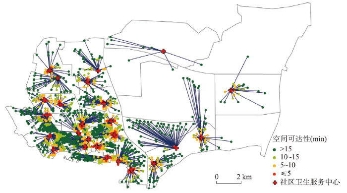
图2
2020年郑州市金水区医疗服务现状
Fig. 2
Healthcare centres and their service areas in Jinshui District, Zhengzhou, 2020
图3
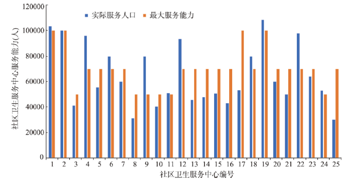
图3
郑州市金水区医疗服务冗余或短缺
Fig. 3
Service redundancy or shortages for healthcare centres in Jinshui District, Zhengzhou
4.2 基于最优供需分配的可达性分析
基于最优供需分配评估服务可达性,具体步骤为:① 在ArcGIS中准备案例数据,包括社区卫生服务中心空间位置及其服务能力,居住小区空间位置及其人口规模。② 计算供应点和需求点的曼哈顿距离,获得OD时间成本矩阵。③ 构建最优供需分配模型,使用CBC开源线性规划求解器对模型求解。④ 计算可达性指标,包括每个需求点使用服务旅行时间、特定半径内(≤ 5 min、5~10 min、10~15 min、>15 min)的服务覆盖率等。
实验计算环境:HP桌面计算机,配置Inter® CoreTM i7-7700 CPU和8 GB内存,Window 10操作系统,安装Python 3.8、ArcGIS 10.2和CBC开源线性规划求解器。CBC模型求解时间为2.2 s,获得最优解。
案例区郑州金水区只有46.57%的居民可以在15 min步行范围内到达社区卫生服务中心(表1),该比例远远低于国家所规定的80%的居民“15 min到达医疗点”的目标[44]。利用本文所提出的基于供需最优分配的就医可达性计算方法,分别按照现有每个服务中心的服务能力和最大上限的服务能力,对服务中心的覆盖范围和居民就医的服务中心进行重新分配,可达性计算结果如图4所示。由表1和图4可知,依据服务中心的现有服务能力,重新匹配服务覆盖范围,15 min内到达服务中心的居民数明显提高,占比53.22%;若依据国家社区卫生服务中心建设标准,将服务中心的现有服务能力提高至上限,15 min内到达服务中心的居民数达到54.86%。相对服务中心现状而言,基于空间服务最优分配的可达性方法,有效缓解了供需平衡问题。
表1 郑州市金水区不同时间阈值下医疗服务覆盖统计
Tab. 1
| 分类(min) | 实际服务能力最优分配 | 最大服务能力最优分配 | 服务现状 | |||||
|---|---|---|---|---|---|---|---|---|
| 人数(人) | 占比(%) | 人数(人) | 占比(%) | 人数(人) | 占比(%) | |||
| ≤ 5 | 134038 | 8.29 | 141442 | 8.75 | 120419 | 7.45 | ||
| 5~10 | 368009 | 22.76 | 385789 | 23.86 | 321689 | 19.89 | ||
| 10~15 | 358494 | 22.17 | 359843 | 22.25 | 310973 | 19.23 | ||
| > 15 | 756538 | 46.78 | 730005 | 45.14 | 863998 | 53.43 | ||
图4
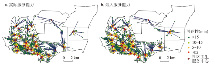
图4
郑州市金水区医疗服务最优分配结果
Fig. 4
The optimal allocation of healthcare services in Jinshui District, Zhengzhou
4.3 与两步移动搜索法对比
本文采用2SFCA计算需求点的可达性,首先,以服务中心为核心,计算15 min步行阈值范围内所有居民点,计算搜寻区内的卫生服务中心和人口数之比;第二步,以每个小区为中心,搜寻阈值时间范围内的服务中心数量,将搜寻区内的各服务中心的比率加和,得到每个小区的就医可达性。
基于简单2SFCA、高斯2SFCA和重力衰减2SFCA分别计算步行15 min(步行速度=72 m/min)时间阈值内各小区点获取基层医疗服务空间可达性。对重力衰减2SFCA模型而言,距离衰减参数β对其可达性结果影响较大。参考文献[40, 45-46],本文对β参数取1、1.2、1.5、1.8、2这5种情况。为便于分析,本文根据自然断点法,将可达性计算结果分为差(≤ 0.4)、较差(0.4~0.8)、一般(0.8~1.2)、较好(1.2~1.6)和好(> 1.6),并对以上6种模型的结果进行对比分析。图5显示不同方法计算的可达性结果呈现出类似的空间特征,案例区“15 min”基层医疗服务可达性呈现出明显的圈层结构。人口密集的文化路、丰产路、京八路、花园路街道所在的老城区可达性较好,而外围街道的医疗可达性较差。尤其是郑东新区基层医疗服务中心较少,小区“15 min”步行获取基层医疗服务可达性较差,部分小区的可达性为0。
图5
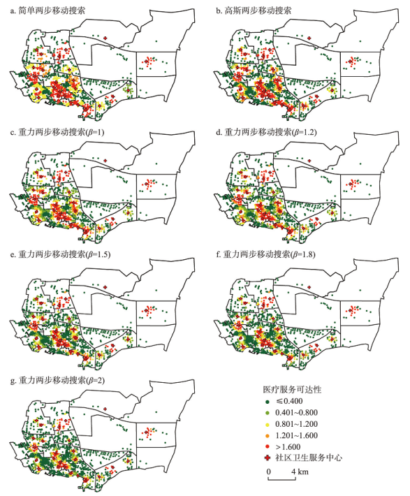
图5
基于2SFCA“15 min”步行搜索半径下郑州市金水区医疗服务可达性分布
Fig. 5
Maps of healthcare services accessibility assessed by 2SFCA within a "15-minute" walking search radius
表2显示,基于简单2SFCA,“15 min”步行搜索半径下基层医疗服务空间可达性良好的居民,占比为30.89%;高斯2SFCA显示,医疗服务空间可达性良好的居民,占比为32.29%。重力2SFCA计算结果随β取值不同而差异较大。随β取值增加,医疗服务空间可达性“较好”和“好”这两个级别的居民占比呈逐渐下降趋势,分别为28.57%(β = 1)、26.26%(β = 1.2)、22.37%(β = 1.5)、17.56%(β = 1.8)和15.75%(β = 2)。
表2 基于2SFCA“15 min”步行搜索半径下医疗服务可达性统计(%)
Tab. 2
| 可达性计算方法 | 差(≤ 0.4) | 较差(0.4~0.8) | 一般(0.8~1.2) | 较好(1.2~1.4) | 好(> 1.4) |
|---|---|---|---|---|---|
| 简单2SFCA | 42.82 | 4.12 | 22.16 | 7.94 | 22.95 |
| 高斯2SFCA | 51.51 | 6.63 | 9.57 | 7.97 | 24.32 |
| 重力2SFCA(β=1) | 43.43 | 17.26 | 10.75 | 6.95 | 21.62 |
| 重力2SFCA(β=1.2) | 46.01 | 19.13 | 8.60 | 7.44 | 18.82 |
| 重力2SFCA(β=1.5) | 52.93 | 15.63 | 9.06 | 7.34 | 15.03 |
| 重力2SFCA(β=1.8) | 59.97 | 13.54 | 8.93 | 3.93 | 13.63 |
| 重力2SFCA(β=2) | 63.60 | 14.09 | 6.56 | 3.10 | 12.65 |
5 结论与讨论
本文在综合考虑公共服务设施供需不平衡前提下,采用经典的运输问题模型确定最优的服务供需分配方案,进而度量服务的空间可达性,并以郑州市金水区社区卫生服务为例,采用两步移动搜索法和最优供需分配模型,求解可达性。
案例研究表明:① 本文所提方法计算简单,求解高效,使用CBC求解器,模型计算时间约为2.2 s。也可采用CPLEX、GUROBI等商用软件计算,计算时间约为0.2~0.3 s。② 与传统的公共服务设施空间可达性度量方法(潜力模型和累积模型等)相比,最优供需分配模型在衡量设施空间可达性方面具有诸多优势。该模型运算不涉及参数选择,其计算结果物理意义明确;可灵活地用于统计公共设施服务指标(如人均使用服务旅行时间、各需求点使用服务旅行时间、各设施使用者的平均旅行时间、特定半径内的服务覆盖率等),制作各种专题地图。有效衡量公共服务设施供给与需求空间分布差异性以及供给能力和需求的差异性,识别空间上设施可达性较差区域,能够弥补现有方法的不足。
本文方法能够用于基础医疗、义务教育、绿色空间等公共服务空间可达性评估。公共服务体系中,存在动态需求、设施变动(增减或者重新选址)和交通条件变化等情景。服务体系发生变化时,可使用本文方法重新评估其可达性,判断公共服务水平是否有所改进及是否有必要调整。也应当注意本文案例数据的局限性。在“15 min社区生活圈”内,现有社区卫生服务覆盖人口的比率明显低于国家所计划的目标,原因可能是数据采集不完备、人口数据不够精确等。为更好地满足社区卫生服务覆盖及便捷性要求,可通过以下几种方式改进:扩充现有设施的容量、增加新设施或调整现有设施位置等。本文可达性模型未考虑需求点居民的需求偏好,未来的设施布局规划及可达性评估研究,应考虑居民的需求偏好,打造高质量和人性化的公共服务体系。
参考文献
The characteristics of inter-city commuting in Guangzhou under the context of regional integration
区域一体化下的广州市居民城际通勤特征分析
How accessibility shapes land use
DOI:10.1080/01944365908978307 URL [本文引用: 2]
The measurement of accessibility: Some preliminary results
DOI:10.1007/BF00165245 URL [本文引用: 1]
Dynamic cities: Location-based accessibility modelling as a function of time
DOI:10.1016/j.apgeog.2018.04.009 URL [本文引用: 1]
Individual accessibility revisited: Implications for geographical analysis in the twenty-first century
DOI:10.1111/j.1538-4632.2003.tb01119.x URL [本文引用: 1]
Modeling accessibility of screening and treatment facilities for older adults using transportation networks
DOI:10.1016/j.apgeog.2018.02.013 URL [本文引用: 1]
Measures of spatial accessibility to healthcare in a GIS environment: Synthesis and a case study in Chicago region.
Measuring spatial accessibility to primary care in rural areas: Improving the effectiveness of the two-step floating catchment area method
DOI:10.1016/j.apgeog.2008.12.003 URL [本文引用: 2]
Evaluation method of medical facilities service coverage in mountainous cities based on map data.
融合地图数据的山地城市医疗设施服务覆盖评估方法研究
Accessibility to urban parks for elderly residents: Perspectives from mobile phone data
Will the opening community policy improve the equity of green accessibility and in what ways? Response based on a 2-step floating catchment area method and genetic algorithm
Exploring the disparities in park access through mobile phone data: Evidence from Shanghai, China
DOI:10.1016/j.landurbplan.2018.09.013 URL [本文引用: 1]
Which communities have better accessibility to green space? An investigation into environmental inequality using big data
Multi-scale accessibility of green spaces and its equity in Guangzhou based on multi-mode two-step floating catchment area method (M2SFCA)
基于多出行模式两步移动搜索法的广州多尺度绿地可达性与公平性研究
Spatial accessibility evaluation and layout optimization of basic education facilities in community life circle: A case study of Shahekou in Dalian
DOI:10.13249/j.cnki.sgs.2020.11.002
[本文引用: 1]

As an important part of basic public service facilities, basic education facilities are of great significance for improving the quality of life of residents and improving the efficiency of urban operations. At present, the research on educational facilities is comprehensive, mainly focusing on spatial layout, spatial accessibility and facility configuration. However, in the research scale, residential units and even subdistrict are mostly basic units. Such accuracy is obviously poor. This paper uses UNA toolkit, which based on Rhino, to analyze the spatial accessibility of three basic education facilities in kindergarten, elementary school and junior high school in Shahekou District of Dalian from the residential building and community level, and proposes optimization ideas and site-selection schemes. The main conclusions are as follows: 1) The spatial distribution of various basic education facilities is uneven, and there are phenomena of duplication and lack of coexistence; the phenomenon of “dislocation” of facilities and residential buildings is serious. 2) All kinds of basic education facilities have the problem of a small number of residential buildings within the service area. It will take a long time and distance to go to school. If the facility only serves residents within the scope of the specified service, some facilities may be underutilized. 3) In the scope of the prescribed services, junior high schools have the largest proportion of accessibility, followed by primary schools and kindergartens. Outside the prescribed scope of services, kindergartens have the worst accessibility, followed by junior high schools and primary schools. 2.97% of residential buildings with poor accessibility of the three types of facilities. These areas should give priority to adding education facilities. 4) In consideration of supply, demand and accessibility, two new facilities reference site selection schemes were proposed.
社区生活圈基础教育设施空间可达性评价与布局优化研究: 以大连市沙河口区为例
Job displacement and the duration of joblessness: The role of spatial mismatch
DOI:10.1162/REST_a_00707 URL [本文引用: 1]
Place rank: Valuing spatial interactions
DOI:10.1007/s11067-011-9153-z URL [本文引用: 1]
Job accessibility, residential segregation and risk of long-term unemployment in the Paris region
The research presented in this paper explores, in the French context, the hypothesis that employment problems experienced by low-skilled jobseekers are partially caused by spatial urban factors. Many low-skilled workers live in poor neighbourhoods where they are exposed to a distressed social environment and/or weak job accessibility. For reasons discussed in this article, living in such neighbourhoods may increase the duration of unemployment for jobseekers. On the basis of an empirical study, this hypothesis is tested in the Paris-Ile-de-France metropolitan area and addresses the question: all other things being equal, are low-skilled workers living in high-poverty neighbourhoods and/or neighbourhoods with low job accessibility exposed to a greater risk of long-term unemployment?
A three-step floating catchment area method for analyzing spatial access to health services
DOI:10.1080/13658816.2011.624987 URL [本文引用: 2]
Estimating the effect of turn penalties and traffic congestion on measuring spatial accessibility to primary health care
DOI:10.1016/j.apgeog.2012.12.003 URL [本文引用: 2]
A method to evaluate equitable accessibility: Combining ethical theories and accessibility-based approaches
DOI:10.1007/s11116-015-9585-2 URL [本文引用: 2]
Assessing spatial equity: An evaluation of measures of accessibility to public playgrounds
DOI:10.1068/a300595 URL [本文引用: 2]
Spatial match between residents' daily life circle and public service facilities using big data analytics: A case of Beijing
DOI:10.18306/dlkxjz.2021.04.001
[本文引用: 2]
Residents' daily life circle is one of the key issues in relation to the national spatial planning in the "new era". Supply of public service facilities is the primary condition for plan-making of this type of circle. Spatial match between residents' daily life circle and public service facilities reveals the human-environment relationship at the community level. There exist many studies on spatial match between residents' daily life circle and public service facilities. However, the existing findings are mainly based on survey data, which have disadvantages such as insufficient samples, small geography coverage, and so on. This study investigated the spatial match between residents' daily life circle and public service facilities in large cities by taking Beijing as an example. Using mobile phone data and point-of-interest (POI) data collected in 2018, this study measured the spatial range of residents' daily life circle and accessibility of public service facilities, and analyzed the relationship between the spatial range of residents' daily life circle and accessibility of public service facilities by the bivariate spatial autocorrelation method. It also analyzed the geographical variations in the relationship. The results of analysis show that residents' daily life circle has a multi-centric structure at the city level. The length of radius of the circle increases from the central areas to the periphery. Accessibility of public service facilities is featured with a zonal structure but its level decreases with the distance away from the centers. The level of accessibility is negatively related with radius of the circle, which means that the higher level of accessibility, the smaller radius of the circle. There are geographical variations in the relationship. The relationship is "high-low" in the city center and new town centers, but dominated by "low-low" and "low-high" pattern in the fringe of the city center and new town centers. There are also variations in the relationship between different types of public service facilities. For the cultural and leisure facilities, the degree of spatial match between residents' daily life circle and public service facilities is obvious lower than other facilities. The conclusion of this research provides new evidence for residents' daily life circle study, and has policy implications for residents' daily life circle planning.
基于大数据的生活圈范围与服务设施空间匹配研究: 以北京为例
Accessibility based on Gravity-Radiation model and Google Maps API: A case study in Australia
DOI:10.1016/j.jtrangeo.2018.09.009 URL [本文引用: 1]
Disability support services in Queensland, Australia: Identifying service gaps through spatial analysis
Measuring potential physical accessibility to general practitioners in rural areas: A method and case study
DOI:10.1016/0277-9536(82)90428-2 URL [本文引用: 3]
Geographic access to cancer care in the US
DOI:10.1002/cncr.23229 URL [本文引用: 2]
Location characteristics of inner-city neighborhoods and employment accessibility of low-wage workers
DOI:10.1068/b250345 URL [本文引用: 1]
Spatial accessibility of urban medical facilities based on improved potential model: A case study of Yangpu district in Shanghai
基于改进潜能模型的城市医疗设施空间可达性: 以上海市杨浦区为例
An enhanced two-step floating catchment area (E2SFCA) method for measuring spatial accessibility to primary care physicians
Measuring spatial accessibility to primary care in rural areas: Improving the effectiveness of the two-step floating catchment area method
DOI:10.1016/j.apgeog.2008.12.003 URL [本文引用: 2]
Variable catchment sizes for the two-step floating catchment area (2SFCA) method
Comparing GIS-based methods of measuring spatial accessibility to health services
DOI:10.1007/s10916-006-7400-5 URL [本文引用: 1]
Spatial accessibility of primary care: Concepts, methods and challenges
Primary care is recognized as the most important form of healthcare for maintaining population health because it is relatively inexpensive, can be more easily delivered than specialty and inpatient care, and if properly distributed it is most effective in preventing disease progression on a large scale. Recent advances in the field of health geography have greatly improved our understanding of the role played by geographic distribution of health services in population health maintenance. However, most of this knowledge has accrued for hospital and specialty services and services in rural areas. Much less is known about the effect of distance to and supply of primary care on primary care utilization, particularly in the U.S.For several reasons the shortage of information is particularly acute for urban areas, where the majority of people live. First, explicit definitions and conceptualizations of healthcare access have not been widely used to guide research. An additional barrier to progress has been an overwhelming concern about affordability of care, which has garnered the majority of attention and research resources. Also, the most popular measures of spatial accessibility to care - travel impedance to nearest provider and supply level within bordered areas - lose validity in congested urban areas. Better measures are needed. Fortunately, some advances are occurring on the methodological front. These can improve our knowledge of all types of healthcare geography in all settings, including primary care in urban areas.This paper explains basic concepts and measurements of access, provides some historical background, outlines the major questions concerning geographic accessibility of primary care, describes recent developments in GIS and spatial analysis, and presents examples of promising work.
Black residential segregation, disparities in spatial access to health care facilities, and late-stage breast cancer diagnosis in metropolitan Detroit
Function simulation and regularity of distance decay of inter-urban traffic flow in China
中国交通流的衰减函数模拟及特征
Quantifying the distance effect in spatial interactions
空间交互作用中的距离影响及定量分析
Evaluation of the spatial equity of medical facilities based on improved potential model and map service API: A case study in Zhengzhou, China
Accessibility analysis of medical services in Shanghai based on improved 2SFCA
[D].
基于改进两步移动搜索法的上海市医疗服务可达性分析
[D].
Standard of service capacity of community health service centers (2018 edition)
http://www.nhc.gov.cn/jws/s7882/201809/d77cd05877b84909b0bd0e8b92a3e5f8.shtml, 2018-08-22.
社区卫生服务中心服务能力标准(2018年版)
http://www.nhc.gov.cn/jws/s7882/201809/d77cd05877b84909b0bd0e8b92a3e5f8.shtml, 2018-08-22.]
More than 80% of residents can reach the nearest medical point within 15 minutes
http://www.nhc.gov.cn/libin/mtbd/201710/d25a52d908b64ba492dcd 212b5a91b86.shtml, 2017-10-22.
80%以上居民15分钟内就能到达最近的医疗点.
http://www.nhc.gov.cn/libin/mtbd/201710/d25a52d908b64ba492dcd212b5a91b86.shtml, 2017-10-22.]
Research on spatial accessibility to health service-A case study in the Haizhu district of Guangzhou
公共医疗卫生服务的空间可达性研究: 以广州市海珠区为例
