

1 引言
尽管高山区泥石流的起动区多为人迹罕至的高山冰雪/冻土坡面(或上游沟谷),但由于其流速高,演进距离长,且在演进过程中规模常会显著增大,因而这类泥石流过程多破坏力巨大,易造成下游基础设施及居民生命财产的重大损失。高山区众多典型泥石流灾害事件,如1962年和1970年秘鲁安第斯山脉Rio Santa山谷泥石流[4]、2002年俄罗斯高加索山区北奥赛梯Kolka-Karmadon冰川泥石流[5]、2010年加拿大Meager山区泥石流[6]、2012年和2017年瑞士阿尔卑斯山区Bondasca山谷泥石流[7]、中国藏东南、川西贡嘎山及新疆天山地区等多发的冰川(或冰雪—降雨耦合)泥石流,以及2021年印度北部北阿肯德邦喜马拉雅山地冰湖溃决泥石流等表明,应高度重视高山区泥石流的现实危害和潜在风险。
泥石流运动伴随强烈的侵蚀—搬运—堆积过程,不但沟道自身发生强烈冲淤变化,还输送大量泥沙进入主河,改变河道水沙过程和地貌形态,并影响河谷地貌的长期演变,因而具有显著的地貌效应[8,9,10,11]。由于泥石流过程通常伴随上中游沟道的强烈冲蚀和下游沟道剧烈淤积,相关研究致力于明晰影响泥石流冲刷能力和淤积规模的主要因素[12,13],如分析沟道坡度[14,15]和泥石流体物质构成(水分含量、颗粒粒径)[16]等与泥石流侵蚀能力和堆积特征的关系;探讨泥石流流变特性对冲积扇地貌形态的影响[17]等。另外,对泥石流沟纵剖面演化模式[18]、泥石流底蚀[19]和侧蚀[20]过程作用机制、不同地貌特征的泥石流沟发育类型[21],以及泥石流与主河交汇机理[22]等方面也开展了探索。
2 研究区及研究方法
2.1 研究区域
帕隆藏布流域位于藏东南雅鲁藏布江大拐弯北部,是雅鲁藏布江下游主要支流(图1),其流域面积约2.86万km2,干流河长266 km,落差3380 m,平均坡降12.7‰,多年平均年径流量约300亿m3 [25,26]。这一区域地层岩性以中—深变质岩为主,包括片岩、片麻岩、变粒岩、角闪质岩、大理岩等,局部出露花岗岩[27]。区域地处东喜马拉雅构造结,地壳新构造运动强烈,抬升显著,地震频率高[26]。这里山高坡陡谷深,地形变化剧烈。由于地处西南季风进入青藏高原的重要水汽通道上,帕隆藏布流域降水丰沛,海洋性冰川广布[28]。受区域地层岩性、地壳运动、地形地貌、气候、人类活动等因素的共同影响,流域内山地灾害多发,灾害点广泛分布[26, 29]。20世纪60年代以来,帕隆藏布流域气温和降雨发生明显变化,尤其升温趋势十分显著(图2)。在这一背景下,流域内海洋性冰川快速消融退缩[1, 30],大量松散冰碛物外露。气候变化使流域潜在孕灾环境更易于成灾,客观上促进了泥石流灾害发生[31],改变或重塑沟谷乃至流域地貌过程。
图1
图1
帕隆藏布流域及3条典型泥石流沟示意图
注:图b~c为2016年资源3号卫星影像;图d为2018年Landsat 8影像;虚线I-IV为横断面位置。
Fig. 1
The Parlung Zangbo basin and three typical debris flow gullies
图2
图2
1961—2020年藏东南波密站气温和降雨变化
注:数据来源于中国气象科学数据中心(http://data.cma.cn)。
Fig. 2
Variations of air temperature and precipitation monitored at Bomi Meteorological Station in southeast Tibet during 1961-2020
表1 古乡沟、天摩沟、扎木弄沟基本特征及典型泥石流事件
Tab. 1
| 流域面积(km2) | 主沟长度(km) | 高程 (m) | 平均纵坡(%) | 泥石流暴发 时间 | 泥石流规模(106 m3) | 成因 | 参考 文献 | |
|---|---|---|---|---|---|---|---|---|
| 古乡沟 | 25.2 | 8.7 | 6298~2530 | 25.6 | 1953.09.29 | 11 | 1950年地震引发滑坡堵塞沟谷上游形成堰塞体;1953年降雨和升温造成堰塞体溃决 | [33-35] |
| 1975 | / | 冰崩 | [33-35] | |||||
| 2005.07.30—08.06 | 0.3~0.4 | 升温及强降雨引发冰崩滑坡 | [36] | |||||
| 2020.07 | / | 降雨 | 本文 | |||||
| 天摩沟 | 17.8 | 7.1 | 5560~ 2460 | 27.2 | 2007.09.04 | ~1.0 | 升温和降雨引发冰崩/岩崩/滑坡 | [37-38] |
| 2010.07.25 | 0.1~0.5 | 强降雨和升温引发崩滑堵塞沟道,后溃决 | [37-38] | |||||
| 2010.09.03 | 0.1~0.5 | 降雨升温 | [37-38] | |||||
| 2018.07.11 | 0.18 | 升温及降雨引发岩崩 | [39] | |||||
| 扎木弄沟 | 29.4 | 9.7 | 5616~ 2186 | 27.7 | 1900 | 510 | 前期降雨和升温 | [40-41] |
| 2000.04.09 | 280~300 | 升温和降雨引起滑坡 | [42-43] | |||||
| 2015.08 | 0.06 | 降雨 | [44] | |||||
| 2020.07 | 0.01~0.1 | 降雨 | 本文 |
2.2 研究方法
对研究区河道和典型泥石流沟谷进行野外实地踏勘调查。采用图帕斯(TruPulse 200, 量程1000 m ±20 cm)激光测距仪测量沟道(河道)地形(距离、高差、坡度等);使用无人机(DJI Phantom 4 Pro)航拍沟道出口冲积扇地形;同时布置参考控制点,采用高精度RTK系统(合众思壮G970II Pro)测量以矫正航测数据高程误差。航拍影像经Pix4D mapper、Cloud Compare、ArcMap软件处理,获得亚米级精度DEM数据。目前在典型泥石流沟道出口冲积扇开展4次无人机航拍(时间分别为2020年5月中旬、9月下旬和12月上旬、2021年5月中旬),以精细记录年内汛前和汛后泥石流冲积扇冲淤变化和流道摆动。由于研究区谷深坡陡,地形变化大,沟道的流通段和物源区未进行航拍。
搜集整理研究区典型泥石流事件和地貌过程有关历史文献资料。下载SRTM 3(90 m精度)、ASTER GDEM V3(30 m精度)高程数据,运用ENVI、ArcGIS软件对DEM数据进行坐标系转换、几何校正、裁剪拼接等处理,提取河道纵剖面和典型沟道地形。基于Google Earth数据得到古乡沟上游物源区横断面。在USGS、地理空间数据云网站下载帕隆藏布流域1987—2021年Landsat系列(Landsat 5、Landsat 7、Landsat 8)遥感影像数据,以比较典型泥石流事件发生前后河道平面形态变化。选取不同年份非汛期遥感影像进行解译分析,采用ArcGIS、Photoshop软件对影像进行波段合成、裁剪拼接等处理。为定量分析堰塞体上游河道分汊强度变化,采用辫状强度系数BIT和PT进行计算[32]:
式中:BIT即河段平均汊道数(又称汊道数指数);∑NL为河段横断面总汊道数;NXS为河段等距分段后的横断面数;PT为河段汊道总长度与河段长度比值;∑LL为河段所有汊道总长度(m);Lr为河段长度(m)。
3 结果
3.1 泥石流沟自身地貌的发育特征
泥石流的起动和演进伴随沟道短暂而剧烈的冲淤变化。泥石流的冲淤过程是泥石流和沟道相互作用的过程,其影响因素包括泥石流体性质、流量、流速、侵蚀基准以及沟床和沟岸物质组成等。帕隆藏布流域的泥石流沟道上游物源区多为粒雪盆,蓄积冰川积雪、冰碛物等。受气候变化影响,帕隆藏布流域冰川积雪消融蚀退,如天摩沟上游冰川面积从2000年1.77 km2缩小到2013年1.42 km2 [38],大量原本受冰雪覆盖的冰碛物外露,为泥石流发生准备了适宜的物源和地形条件。
泥石流沟谷上游物源区的沟道地貌变化以下切、展宽和溯源蚀退为主要特征。古乡沟上游物源区是典型的高山冰蚀围谷,其内蓄积了巨量的冰碛物(和坡积物)。1950年以来,升温和降雨形成的冰川融雪径流及滑坡、崩塌、泥石流过程不断切割冰蚀围谷内的冰碛物坡体,沟道尺度规模不断增大,地形愈发破碎(图3a~3c)。基于文献[33]数据示意性勾勒的古乡沟上游主沟道(图3b)的断面变化(图3d)显示,自1953年古乡沟特大泥石流发生后,其上游主沟道经历了强烈的冲刷切深和侧蚀展宽过程(1953—1965年更为显著),后由于物源区沟道下段逐渐切至基岩,其下切速率受到抑制,展宽速率也相应降低。同时,由于强烈的溯源侵蚀,主沟道末端向上游推进了约2 km。古乡沟物源区沟道的发育过程实际上就是“准”泥石流物源向真正泥石流转化的过程。需要指出,文献[33]中古乡沟物源区主沟道深度与基于Google Earth、ASTER GDEM等地形高程数据提取得到的沟道深度相差较大,可能是断面位置不同或两个数据源各自误差累积所致,并不影响对沟道地貌变化过程基本特征的反映和刻画。
图3
图3
古乡沟上游物源区地貌发育过程
注:断面Ⅰ视角向上游,基于Google Earth高程数据生成;图b为2015年漆力健摄;图d数据来源于文献[33]。
Fig. 3
Morphology evolution of the debris source area at the upper reach of the Guxiang Gully
图4
图4
泥石流沟中游流通区物源特征
注:红色箭头示意坡积物滑坡崩塌,沟道下切展宽;图a余国安于2019年拍摄;图b~c余国安于2020年拍摄。
Fig. 4
Debris mass characteristics of transferring section in the middle reaches of the three gullies
泥石流出口堆积扇的地貌形态变化受泥石流规模和径流强度共同影响。尽管处于泥石流运动活跃期的流域其沟口堆积扇一般多呈净淤积状态,但通常有显著的冲淤变化,其变化幅度与上游来水来沙过程密切相关。泥石流从上游搬运大量固体物质到出口堆积,整个过程历时短但强度大,堆积扇常显著淤积抬升。泥石流事件之间的间歇期,沟道形态变化缓慢,在水流持续冲刷作用下,沟床逐渐下切,其速率受水流能量(由流量和坡降决定)、堆积扇物质构成等因素影响,而这些影响因素又与降水、气温、沟床物质组成(大颗粒粒径及粒径级配)息息相关。总体而言,泥石流事件引起沟口堆积扇淤积抬升,一般水沙过程(尤其汛期洪水过程)促进沟道冲刷下切。
图5
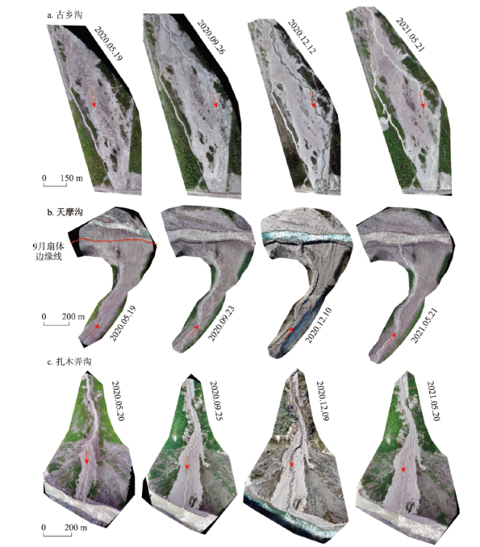
图5
基于无人机航拍数据生成的泥石流沟沟口堆积扇
Fig. 5
The deposit fans of the three gullies produced based on UAV data
图6
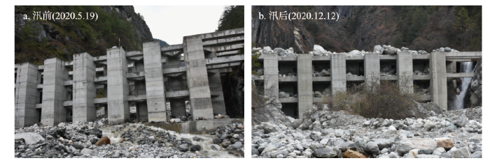
图6
古乡沟中游峡谷出口泥石流工程设施拦蓄泥石流固相(视角向沟道上游)
注:余国安于2020年拍摄。
Fig. 6
Engineering works built at the canyon outlet of the Guxiang Gully to intercept sediment (facing upstream of the gully)
图7
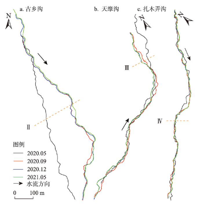
图7
3条泥石流沟出口冲积扇沟道主流线摆动情况
Fig. 7
Wandering of main stream of the three gullies before and after the flood season
图8
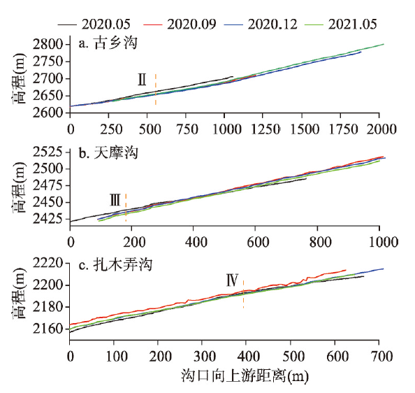
图8
沟口冲积扇主流道纵剖面冲淤变化
Fig. 8
Incision/siltation of the longitudinal profile of the main streams of the three gullies at the deposit fan
图9
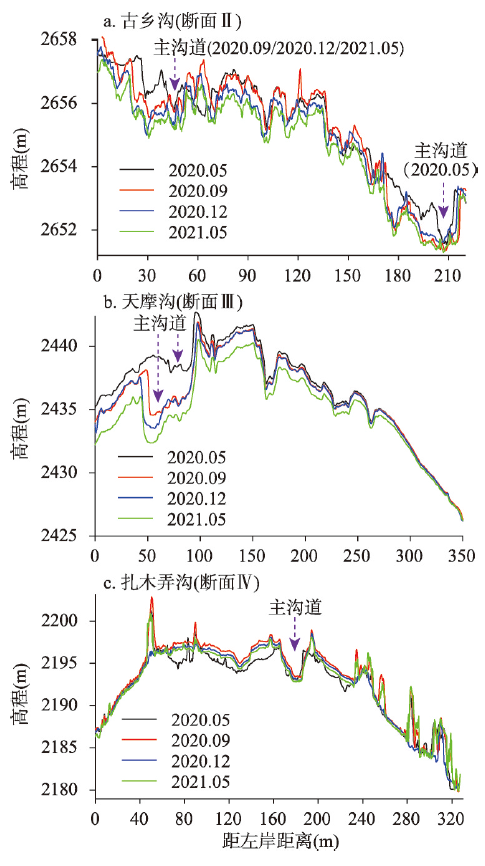
图9
汛期前后泥石流沟出口堆积扇典型横断面冲淤及主沟道摆动
Fig. 9
Variation of cross sectional profiles and wandering of main stream before and after the flood season
图10
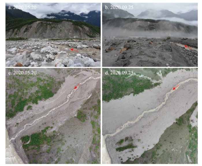
图10
2020年汛期泥石流事件前后扎木弄沟沟口堆积扇冲淤变化
注:余国安于2020年拍摄。
Fig. 10
Variation of deposit fan of Zhamunong Gully before and after debris flow in flood season in 2020
由于上游物源减少及工程措施控制,2020年古乡沟(图5a)泥石流输送的固体颗粒被大量拦蓄于中游峡谷段(图6),进入沟道下游的泥石流规模很小或弱化为高含沙水流甚至山洪,沟道主流线发生显著横向摆动(图7a),且下游沟道冲刷下切(图8a、图9a)。天摩沟2020年没有发生泥石流事件,但是泥石流扇体形态发生变化,相对于2020年5月份,9月份扇体与帕隆藏布交汇处明显蚀退(图5b,红线),这主要是因为汛期帕隆藏布江水流流速和流量显著增大,剧烈淘蚀、冲刷扇体边缘,沟道主流线也有所摆动(图7b)。由于汛期未发生泥石流,缺乏高强度来沙,天摩沟沟道下游从2020年5月到2021年5月明显下切(图8b、图9b)。扎木弄沟泥石流事件搬运下来的泥沙几乎完全覆盖原来的沟口冲积扇,形成明显区别于周边环境的新泥石流堆积区,扇体区域显著展宽、增大(图5c、图10),沟道主流线在局部区域发生摆动变化,但幅度较小(图7c),堆积扇横断面2020年9月明显高于2020年5月、12月及2021年5月,说明扇体在汛期显著淤积抬升,非汛期侵蚀下切(图8c、图9c)。
3.2 泥石流对帕隆藏布河流地貌的影响
图11
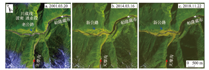
图11
天摩沟泥石流事件前后帕隆藏布河流地貌变化
Fig. 11
Change of morphology of Parlung Zangbo River before and after debris flows from Tianmo Gully
图12
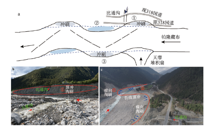
图12
天摩沟泥石流引起帕隆藏布干流河岸冲淤横向连锁反应
Fig. 12
Cascade effects of lateral scouring/siltation of the Parlung Zangbo River caused by debris flows in Tianmo Gully
图13
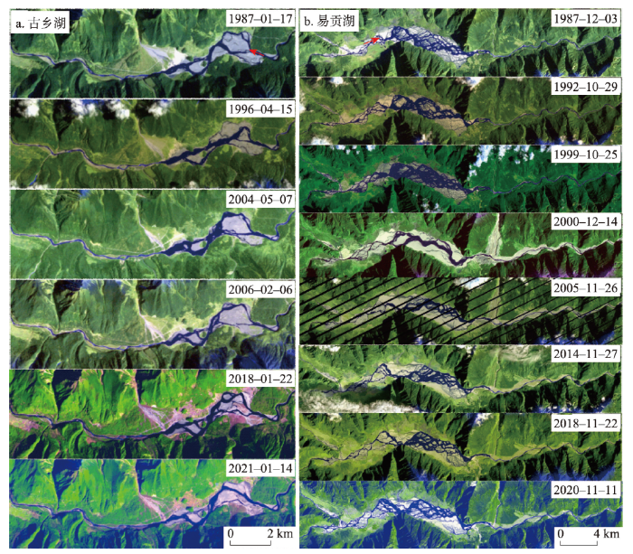
图13
1987—2021年古乡湖和易贡湖遥感影像
Fig. 13
Remote sensing images of Guxiang and Yigong lakes from 1987 to 2021
图14
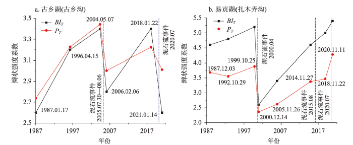
图14
泥石流堰塞体上游河段辫状强度变化与泥石流事件的关系
注:图中1987.12.03表示基于该日影像得到的河道辫状强度系数,其他类推。
Fig. 14
Relationship between braiding intensity of river reach upstream of the dam and debris flow events
古乡湖和易贡湖河道辫状系数的变化显示(图14):① 无泥石流事件时,两个湖区河段的辫状强度系数大体呈升高趋势,说明湖区河段汊道在逐渐发育(即大型汊道冲刷下切,新的汊道逐渐形成)。② 泥石流事件通常引起主河河道辫状强度系数下降,但下降幅度受制于泥石流规模。如,2000年扎木弄沟巨型滑坡泥石流(规模2亿~3亿m3),BIT和PT均显著下降。这个变化的主要原因在于泥石流过程输送泥沙淤高堰塞体,堰塞体上游水位相应上升,促进上游泥沙落淤。一方面,湖区水位上升使得原本出露水面的沙洲没入水下,汊道合并;另一方面,因堰塞体抬升,湖区上游河段来沙将更易于在湖区落淤,汊道数量和长度降低,因而辫状系数下降。相对而言,2015年和2020年扎木弄沟的泥石流规模要小很多(约1万~10万m3量级),BIT和PT原有的变化趋势(逐渐升高)基本没有改变。③ 泥石流事件后,随着堰塞体被水流冲刷而高度逐渐下降和湖区泥沙冲淤达到新的平衡,湖区河段汊道又开始发育,辫状系数逐渐上升。如此往复,循环变化。
4 讨论
4.1 河谷地貌稳定的负反馈响应
藏东南地区地壳运动活跃,更新世以来一直处于强烈抬升中。地壳抬升的同时伴随流水侵蚀,河床不断下切,河谷高差变大,坡体势能累积。随着坡体逼近临界平衡状态,势能的释放将成为偶然中的必然,滑坡、泥石流等地质灾害事件是势能释放的主要方式。气候变化(气温上升、降水增多)和地震等外营力均易引发滑坡、泥石流,将大量泥沙输运至主河,促使河床淤积抬升,并触发河床结构、水沙动态和河流地貌相应发生变化,而这些变化反过来抑制岸坡进一步失稳,形成负反馈,促使河谷地貌进入新的相对稳定阶段(图15)。因而,泥石流等高强度物质输移过程是区域地貌变化的重要驱动力。
图15
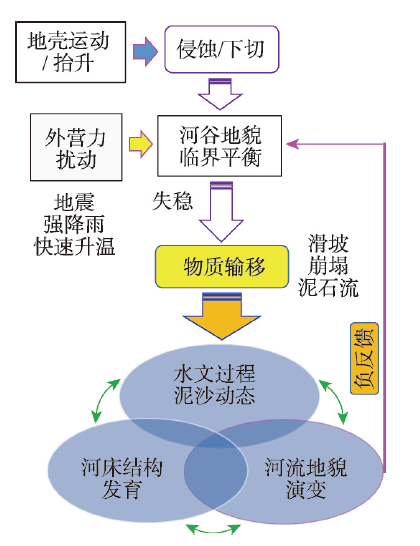
图15
河谷地貌负反馈效应示意图
Fig. 15
Schematic diagram showing the negative feedback of morphology evolution of valleys
4.2 河谷地貌的长期演变
峡谷地区河道由于受滑坡、泥石流等事件影响,入汇处的河床会显著淤积抬升,并可能形成堰塞体(尼克点),抬高侵蚀基准面。如果堰塞体维持稳定,则在长期尺度上,堰塞体上游河道冲刷作用减弱,逐渐转变为平缓宽阔的河谷;堰塞体下游河道继续侵蚀冲刷,下切过程占据主导地位,岸坡势能逐渐增加。随着坡体势能的不断累积,超过临界平衡后,岸坡失稳产生新的堰塞体,形成下一个尼克点。从整体上看,长期时间尺度影响下,帕隆藏布由单一下切河道逐渐演变成纵向上呈台阶状(图16)而平面上呈宽窄相间的“藕节状”的地貌形态[45]。目前帕隆藏布流域已经形成波密古湖、波堆湖、古乡湖等明显尼克点,而天摩沟自从2007年发生泥石流以来,不断输运泥沙进入帕隆藏布,水下堰塞体增高,天摩沟未来能否会形成较为稳定的尼克点以及天摩沟下游是否会发生新的滑坡泥石流事件并形成新的尼克点值得关注。
图16
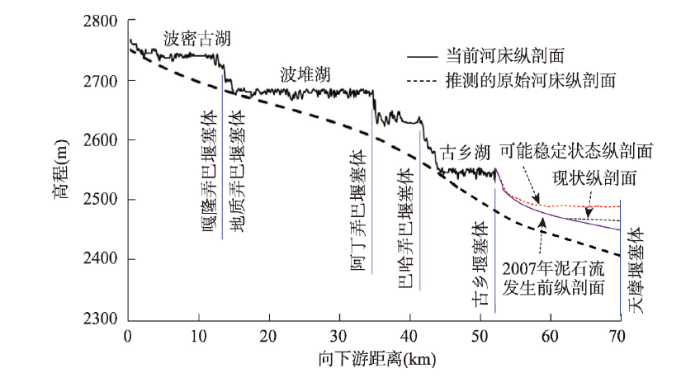
图16
物质输移事件(冰碛坝推进、滑坡、泥石流等)长期影响塑造形成帕隆藏布干流台阶状纵剖面
Fig. 16
Longitudinal profile of a stretch reach of Parlung Zangbo developed by mass movements
4.3 气候变化背景下高山区物质输移主导形式(地质灾害类型)变化
高山区物质输运形式主要包括冰川运动、冰崩、雪崩、崩塌、滑坡和泥石流。末次冰盛期时,全球气温偏低,冰川面积广布,冰川运动占据主导地位,冰碛垄常沿沟谷向下运动深入主河,形成冰碛坝,目前帕隆藏布左岸仍分布众多冰碛坝遗迹(图17),这些冰碛垄(坝)多处于河谷阴坡。随着冰消期的到来,尤其是进入全新世,气候转暖变湿[46],冰川消融,冰碛物外露,滑坡、泥石流运动逐渐占据主导地位,形成众多滑坡体与泥石流堆积扇体,主要分布于帕隆藏布右岸(图17),位于河谷阳坡。近几十年来,由于全球气候变暖,泥石流逐渐成为其中最为重要的物质输运方式,且泥石流沟道由以前主要发育于阳坡开始向河谷阴坡发育(如天摩沟),说明在气候变化(主要为气温上升)的影响下,高山区物质输移的主要方式由冰川运动转变为滑坡、泥石流主导,且泥石流运动对河流地貌影响的重要性呈上升趋势。
图17
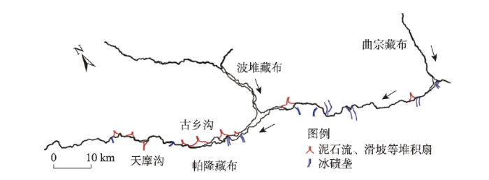
图17
帕隆藏布流域地质灾害分布示意图
Fig. 17
Schematic diagram of different mass movements distributed along the valley of the Parlung Zangbo
5 结论
全球气候变化的大背景下,高山区坡体易于失稳,泥石流成为主要的灾害类型和物质输移形式,也是高山区地貌变化的重要驱动力。藏东南帕隆藏布流域泥石流频发,泥石流小流域自身地貌剧烈变化,上游物源区沟道下切展宽和溯源蚀退,沟口堆积扇冲淤变化受控于泥石流事件规模和径流强度。泥石流过程显著影响主河地貌过程,造成主河河道横向冲淤和摆动,极端泥石流事件输运巨量泥沙进入主河,常形成堰塞体。堰塞体稳定维持后,上游河段平面形态向辫状河型转化,辫状强度受泥石流事件影响而波动变化。在长时间尺度上,主河道在纵剖面上形成台阶状而在平面上发育宽窄相间的藕节状地貌形态。未来应持续关注和研究典型高山区泥石流沟(如天摩沟和新暴发泥石流沟)的地貌变化及泥石流事件(尤其极端事件)对主河(帕隆藏布)河谷地貌和河道形态的影响。
参考文献
Different glacier status with atmospheric circulations in Tibetan Plateau and surroundings
DOI:10.1038/nclimate1580 URL [本文引用: 2]
Alpine glaciers to disappear within decades?
Morphological and ice-dynamical changes on the Tasman Glacier, New Zealand, 1990-2007
DOI:10.1016/j.gloplacha.2009.05.003 URL [本文引用: 1]
A re-examination of the mechanism and human impact of catastrophic mass flows originating on Nevado Huascarán, Cordillera Blanca, Peru in 1962 and 1970
DOI:10.1016/j.enggeo.2009.06.020 URL [本文引用: 1]
The Kolka-Karmadon rock/ice slide of 20 September 2002: An extraordinary event of historical dimensions in North Ossetia, Russian Caucasus
DOI:10.3189/172756504781829710 URL [本文引用: 1]
The 6 August 2010 Mount Meager rock slide-debris flow, Coast Mountains, British Columbia: Characteristics, dynamics, and implications for hazard and risk assessment
Direct observations of a three million cubic meter rock-slope collapse with almost immediate initiation of ensuing debris flows
Valley incision by debris flows: Evidence of a topographic signature
A morphometric analysis of gullies scoured by post-fire progressively bulked debris flows in southwest Montana, USA
DOI:10.1016/j.geomorph.2007.03.016 URL [本文引用: 1]
Quantifying the geomorphic impacts of a lake-breakout lahar, Mount Ruapehu, New Zealand
DOI:10.1130/G30129.1 URL [本文引用: 1]
Development of debris flows in Guanba River and its effect on sediment deposition in Qionghai Lake of Sichuan
DOI:10.11821/dlxb201801007
[本文引用: 1]

Since the late-Cenozoic, the strong uplift of Tibetan Plateau not only formed a large number of tectonic fractures on the southeast edge, but also generated many tectonic rift lakes due to structural stretching and compression. However, in recent years, some of the lakes started to shrink and depicted a reduction in lake depth, which has eventually exerted great influence on local ecological environment and socio-economic development. In this paper the Qionghai Lake, located on the southeast edge of the Tibetan Plateau, is selected as the study area. Based on exploring the debris flow characteristics of Guanba river in the north of Qionghai Lake, the effect of sediment deposition deriving from debris flows on Qionghai Lake is analyzed. The research shows that: (1) The scale and frequency of debris flow occurrence is higher in the Guanba River, and the primary material sources are landslide and non-point source erosion with a movable volume of 428.03×10⁴ m3. (2) The frequent occurrence of floods and debris flows are the primary cause of sediment accumulation in the Qionghai Lake, and the debris flows are controlled by the coupling effect of frequent earthquakes and heavy rainfall. It is predicted that debris flows will still occur frequently, and sedimentation disasters will become more severe in the future. (3) Since 1950, the average deposition rate was about 17.09 mm/a. In terms of current deposition rate, it is inferred that the longevity of the Qionghai Lake will be only about 600 years. (4) The comprehensive governance model with management of administrative law is proposed in the Guanba River. The results can not only provide reference bases for planning management and disaster prevention in Qionghai Lake basin, but also contribute to reveal the reason of lake shrinkage on the southeast edge of Tibetan Plateau.
官坝河泥石流发育特征及对四川邛海的泥沙淤积效应
How memory effects, check dams, and channel geometry control erosion and deposition by debris flows
Debris flows can grow greatly in size and hazardous potential by eroding bed and bank material, but effective hazard assessment and mitigation is currently hampered by limited understanding of erosion and deposition dynamics. We have collected high-resolution pre- and post-flow topography for 6 debris flows over a 3 km long unconsolidated reach of the Illgraben channel in the Swiss Alps with drone-based photogrammetry. We show that the spatio-temporal patterns of erosion and deposition in debris-flow torrents are highly variable and dynamic. Check dams strongly control the spatial patterns of erosion and deposition. We identify a memory effect where erosion is strong at locations of strong deposition during previous flows and vice versa. Large sediment inputs from subcatchments initially result in new channel erosion through the subcatchment deposits and simultaneous upstream deposition, likely as a result of backwater effects. It is generally believed that erosion increases with debris-flow magnitude, but we show that there is a limit to debris-flow bulking set by channel geometry. These findings provide key guidelines for flow volume forecasting, emphasizing the importance of memory effects and the need to resolve both erosion and deposition in predictive models.
Dynamic controls on erosion and deposition on debris-flow fans
DOI:10.1130/G32103.1 URL [本文引用: 1]
Analysis on the deposition processes and characteristics of non-homogeneous debris flow
不同坡度条件下非均质泥石流堆积过程与特征
Channel scour and fill by debris flows and bedload transport
DOI:10.1016/j.geomorph.2015.05.003 URL [本文引用: 1]
Bed scour by debris flows: Experimental investigation of effects of debris-flow composition
DOI:10.1002/esp.v41.13 URL [本文引用: 1]
The influence of debris-flow rheology on fan morphology, Owens Valley, California
DOI:10.1130/0016-7606(1992)104<0887:TIODFR>2.3.CO;2 URL [本文引用: 1]
Model of minimum energy dissipation in evolution of valley longitudinal profile of debris flow in Southeast Tibet area
藏东南泥石流沟纵剖面演化的最小功模式
Elementary theory of bed-sediment entrainment by debris flows and avalanches
The role of bank erosion on the initiation and motion of gully debris flows
DOI:10.1016/j.geomorph.2017.02.008 URL [本文引用: 1]
Geomorphological characteristics of debris flow gullies on the edge of the Qinghai-Tibet Plateau
DOI:10.11821/dlxb202007004
[本文引用: 1]
The edge of the Qinghai-Tibet Plateau is characterized by high topographic relief, significant tectonic motion, extreme precipitation, and densely populated active debris flow gullies. It is essential to scientifically categorize the debris flow gullies to understand their mechanisms, prevent and mitigate debris flow disasters, and find out strategies to restore the ecology. The present study carried out topographical measurements and statistical analyses of seven regions on the edge of the Qinghai-Tibet Plateau, in which active debris flow gullies are concentrated. The debris flow gullies are classified into three types by means of nonmetric multidimensional scaling. Type I is formed by rainstorms in exposed bedrock areas, Type II is formed by glaciers in exposed bedrock areas, and Type III is formed by rainstorms in depositional basins. The variation in landforms of the three types is analyzed using Kruskal-Wallis tests. The sources of loose material and the characteristics of water flow and sediment transport in all the three types of debris flow gullies are discussed from the aspects of geology, topography, and climate. It is shown that the activity of Type II increases along with the warming of the Qinghai-Tibet Plateau, and the activities of types I and III increase along with the frequency of extreme rainfalls.
基于地貌特征的青藏高原边缘泥石流沟分类
Debris flow sediment transportation and its effects on rivers in mountain area
泥石流输沙及其对山区河道的影响
Erosion and morphology of a debris flow caused by a glacial lake outburst flood, Western Norway
DOI:10.1007/s10346-008-0118-3 URL [本文引用: 1]
Geomorphic evidence for present-day snow-avalanche and debris-flow impact in the Icelandic Westfjords
DOI:10.1016/j.geomorph.2005.09.007 URL [本文引用: 1]
Characteristics of recent temperate glacier fluctuations in the Parlung Zangbo River basin, southeast Tibetan Plateau
近期藏东南帕隆藏布流域冰川的变化特征
Research and prospect on formation mechanism of debris flows in high mountains under the influence of climate change
气候变化影响下高山区泥石流形成机制研究及展望
Defining and measuring braiding intensity
DOI:10.1002/esp.1658 URL [本文引用: 1]
Debris flow development trend of Guxiang ravine, Xizang
西藏古乡沟泥石流发展趋势
Influence of debris supply on the activity of post-quake debris flows
物源条件对震后泥石流发展影响的初步分析
Meteorology conditions for frequent debris flows from Guxiang valley in Tibet, China
西藏古乡沟泥石流与气象条件的关系
Cause of debris flow in Guxiang valley in Bomi, Tibet Autonomous Region, 2005
2005年西藏波密古乡沟泥石流暴发成因分析
Geohazard cascade and mechanism of large debris flows in Tianmo gully, SE Tibetan Plateau and implications to hazard monitoring
DOI:10.1016/j.enggeo.2017.12.013 URL [本文引用: 3]
Meteorological factors driving glacial till variation and the associated periglacial debris flows in Tianmo Valley, south-eastern Tibetan Plateau
Formation mechanism and disaster characteristics of debris flow in the Tianmo gully in Tibet
西藏天摩沟泥石流形成机制与成灾特征
Volume of loose materials and the analysis of possibility of blocking and dam break triggered by debris flows in Zhamunonggou
扎木弄沟滑坡型泥石流物源及堵河溃坝可能性分析
The deposition characteristic of supper debris flow in Tibet
西藏特大规模碎屑流堆积特征
Rapid huge landslide and hazard reduction of Yigong River in the Bomi, Tibet
西藏波密易贡高速巨型滑坡特征及减灾研究
A super-large landslide in Tibet in 2000: Background, occurrence, disaster, and origin
DOI:10.1016/S0169-555X(02)00358-6 URL [本文引用: 1]
Study on the relationship between rainfall frequency and mudslide outbreak frequency: Taking the mudslides in Zhamunonggou, Tibet, in August 2015 as an example
降雨频率与泥石流暴发频率关系研究: 以2015年8月西藏扎木弄沟泥石流为例
Mass flows and river response in rapid uplifting regions: A case of lower Yarlung Tsangpo basin, southeast Tibet, China
DOI:10.1016/j.ijsrc.2020.05.006 URL [本文引用: 1]
