

1 引言
1978年改革开放以来,中国的乡村人口向周边城镇迅速集聚、向沿海地区大规模迁移,这一快速的城镇化进程大幅提高了生产要素的配置效率、推动了经济社会的持续发展和人民福祉的稳步提升,同时也产生了一些突出的矛盾和问题[1]。一方面,渐进式的对外开放和市场化改革、沿海区位和集聚经济的优势地位都使得东部沿海地区和大城市成为新增城镇人口的主要集聚地[2-3],城市群和大城市的资源环境约束趋紧、压力巨大,中西部地区的城镇化潜力有待挖掘[4],中小城市的人口吸引力普遍不足,甚至面临加剧的人口流失风险[3,5]。另一方面,在快速城镇化过程中,土地和户籍等关键制度的城乡二元结构仍将持续存在,劳动力、土地、资本等生产要素单向流入城市,带来乡村人口老龄化、用地空废化、产业空心化等诸多问题,“乡村病”日趋严重[6],城乡协调和一体化发展任务艰巨。
在此背景下,中国城镇化的时空动态引起了诸多研究者的关注,相关研究描绘了中国城镇化发展的历程,刻画了城镇化水平的空间格局,并探究了城镇化格局演变的驱动因素[7⇓-9]。中国的城镇化发展具有典型的阶段性特征,与城乡人口的时空转变过程密切关联[7,10]。改革开放初期至1995年,中国城乡人口同步增长、城镇化速度较慢;随后的25年间则表现出了城镇人口稳步增长、乡村人口稳步减少、城镇化水平迅速提升的典型特点。在全国稳定的城镇化过程中,各地的城镇化呈现出明显的时空动态性:改革开放初期城镇化水平呈现“北高南低”的宏观格局,到2000年逐渐演变为“东高西低”的整体特征[11],随后中西部地区的城镇人口增长速度超过东部,城镇化水平的地区差距趋于缩小[12]。城镇化格局演变是自然地理条件、经济社会发展和政策调控效应综合作用的结果:自然条件的地域差异奠定了城乡人口分布及城镇化的基本格局,并对其变动产生持续影响[13-14];经济发展的非均衡性是人口迁移和城镇化格局变动的核心动力,公共服务等社会性因素的影响效应也逐渐显现[15-16];区域发展政策则通过宏观调控引导人口再分布、优化城镇化格局[11,17]。
上述研究成果为理解中国的城镇化进程提供了丰富的见解,但其多关注城镇化水平的时空格局及其影响因素,鲜少从城乡人口变动的角度解析城镇化的过程和机理。在城镇化研究中引入城乡人口变动视角的必要性主要体现在3个方面:① 城镇化是城镇和乡村人口变动共同作用的结果[9],城镇人口集聚、乡村人口流失都可能提高城镇化水平,但分别对应着两种不同的城镇化路径和模式。因此,从城乡人口变动的角度识别城镇化的地域类型、解析城镇化的路径模式,对于深入理解城镇化的过程具有重要的理论意义。② 同一因素对于城镇和乡村人口的影响可能是复杂的,如发展城镇工业既可能吸引本地乡村人口进城,也可能带动乡村工业化进而同时吸引外来人口进入城镇和乡村地区,前者体现了城镇对乡村的虹吸效应,后者则是扩散效应的反映[18]。因此,分析城乡人口变动的驱动因素之异同,对于深入解析城镇化的动力机制很有裨益。③ 人口迁移模式的多样化对不同地域和等级的城镇和乡村产生了异质性影响[19],如城城迁移导致的城市收缩风险、乡城迁移导致的乡村人口流失[20]、外出人口回流到老家城镇带动的流出地城镇化等[21],从城乡人口变动的视角解析城镇化的类型与机制,能够对城镇化的现实问题更加有效地识别成因、预测趋势并进行更加积极有效的政策应对。
城镇化空间政策的现实意涵和实施过程同样体现了城乡人口的消长或共变关系,系统性的政策评估也离不开城乡人口变动的视角。近10年内出台的新型城镇化和乡村振兴战略提出优化提升东部地区城市群、培育发展中西部地区城市群,构建大中小城市和小城镇协调发展的城镇格局,增强城镇地区对乡村的带动能力,推动城镇化布局形态优化和城乡融合发展。城市群本质上是各级城市、小城镇和乡村地区功能空间的一体化区域[22],城乡产业、资本、物流、交通、信息等要素高度一体化意味着城乡人口的紧密联动关系,成熟城市群常常能实现城乡人口同步增长;而初中期阶段的城市群尚未形成区域一体联动的城乡功能空间,中心城市对远距离迁移人口的吸引力有限,其快速发展反而会吸引周边乡村、小城镇甚至中小城市的人口。城市群之外城镇的发展则主要依靠有限的本地资源,具有较强的等级特征,高等级城市能调动更多本地资源进而吸引更多周边人口,中小城市则可能因本地中心城市和全国性城市群的虹吸效应而面临人口外流风险[3]。从城乡人口变动的视角,将能够有效解析和精准评估东部和中西部城市群、大中小城市在新型城镇化格局优化中的地位和作用,以及乡村振兴战略对城乡协调发展的要求落实情况。
在快速城镇化过程中,中国各地城镇化进程差异很大,城镇化空间格局不断发展演化。近年来城镇化初始水平较低、经济社会发展较为滞后的中西部地区城镇化速度赶超发达的东部沿海地区,将带动城镇化水平的空间均衡化[8,12]。但其背后的城乡人口变动过程仍存在一些争论,例如,中西部城镇化水平的提升主要是其乡村人口加速外流还是外出人口回流到本地城镇的结果?已有研究发现,2010年以来,伴随着沿海地区劳动力和土地成本上涨,内陆地区基础设施和交通条件改善,制造业逐渐从沿海向内陆转移[23],带动了中西部地区外出人口回流和本地人口就近迁移[24⇓-26];但也有研究指出,外出人口回流并非中西部大城市人口增长的主要来源[27],各地产业和交通联系的加强反而加速了中西部地区的人口外流[28]。
2020年开展的第七次全国人口普查为厘清上述争论、把握城乡人口变动与城镇化的最新动态、评估新型城镇化和乡村振兴等相关政策的实施效果提供了可靠的数据支持。本文将基于历次人口普查数据,从城乡人口变动的视角识别城镇化的地域类型,刻画城镇化地域类型的时空演化特征,并进一步探究城乡人口与城镇化地域类型演变的驱动因素,为引导资源要素优化配置和人口合理有序布局,推动新型城镇化建设和乡村振兴提供参考。
2 基于城乡人口变动视角的城镇化地域类型划分方法
2.1 现有城镇化地域类型划分方法及优缺点
早期城镇化地域类型的划分主要基于城镇化水平。1975年Northam提出了城镇化发展水平的“S”型曲线,并根据城镇化率将城镇化划分为3个阶段:初期阶段(Initial Stage)、加速阶段(Acceleration Stage)和后期阶段(Terminal Stage)[29]。陈彦光等基于城镇化水平的Logistic方程,运用导数原理推导了城镇化速度的倒“U”型曲线,把Northam的加速阶段更名为快速阶段(Celerity Stage),并将其细分为加速阶段和减速阶段,从而形成了四阶段划分法,基于中国的城市化过程测算出这4个阶段城镇化率的临界值为30%、50%和70%左右[30]。这种方法仅使用单一的城镇化率指标,简单直接、应用广泛,但由于各地的城镇化基础和发展历程不同,城镇化水平和速度的关系存在区域异质性[31],从而城镇化率这一单一指标很难反映不同地区的城镇化过程特征。
2.2 城乡人口变动与城镇化地域类型的关系
图1
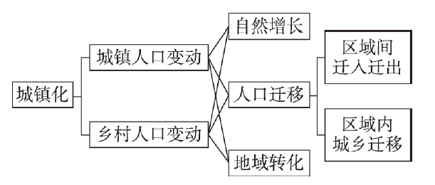
图1
城镇化和城乡人口变动的分析框架
Fig. 1
Analytical framework of urbanization and urban-rural population change
在自然增长和区域间迁入迁出的影响下,城镇和乡村人口常常表现为同向变动,但变动幅度不尽相同:较高的自然增长率对城镇和乡村人口增长均存在积极影响,但城镇人口自然增长一般慢于乡村,从而城镇化水平将降低;区域间的人口迁入将导致城乡人口双增,当人口迁入城镇的可能性高于乡村时,城镇人口增长快于乡村,城镇化水平提升;区域间的人口迁出将导致城乡人口双减,当人口从乡村迁出的可能性高于城镇时,乡村人口减少快于城镇,城镇化水平提升。在区域内城乡迁移和地域转化的影响下,城镇和乡村人口表现为此消彼长:人口从乡村迁移到城镇、地域类型由乡村转化为城镇将带来乡村人口的减少和城镇人口的相应增长,由此推动城镇化水平提升。因此,城镇和乡村人口变动的关系是多样的,城镇化水平提升的情形有多种,可根据城镇和乡村人口变动的方向和规模识别城镇化的地域类型。
2.3 基于城乡人口变动的城镇化地域类型划分
首先假设一个地区的初始城镇常住人口为
图2
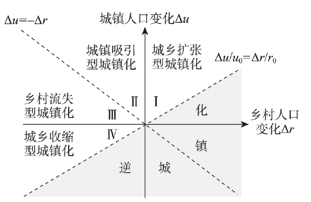
图2
基于城乡人口变动的城镇化地域类型划分
Fig. 2
Regional types of urbanization from the perspective of urban-rural population change
2.4 城镇化地域类型的影响因素
城镇化地域类型是城镇和乡村人口变动的综合体现,是二者不同方向和规模的组合关系,自然地理、经济社会和政策环境等因素通过自然增长、人口迁移和地域转化驱动城乡人口变动,进而塑造了城镇化的地域类型。具体而言,自然地理要素为人类生存和发展提供了物质基础和空间载体,良好的自然地理条件是城市和乡村产生和发展的前提,对于城乡人口变动起基础性作用[35]。经济社会发展推动生活水平改善和生育观念转变进而作用于人口自然增长[36];经济社会活动的增长驱动城市扩张和城乡地域类型转化[37];经济社会发展的不均衡则引发了区域间迁入迁出和区域内城乡迁移[38-39]。政策环境因素对城乡人口变动和城镇化发挥着宏观调控的功能,区域发展政策通过引导土地、投资等经济要素配置而作用于人口变动,进而影响城镇化的地域类型[11]。
本文选取自然地理、经济社会和政策环境3类因素作为自变量,分别采用多元线性回归模型和多项Logit模型考察其对城乡人口变动和城镇化地域类型的影响。模型设定为:
式中:
2.5 数据来源与处理
城乡人口数据来源于《中国1982年人口普查资料》《中国1990年第四次人口普查分县区数据》《2000人口普查分县资料》《中国2010年人口普查分县资料》以及国家和各地级市(地区、自治州、盟)统计局发布的第七次全国人口普查公报。各年份的数据均按照2020年的行政区划进行调整以保证跨时段的可比性,并通过逐步汇总得到地级、省级和全国3个尺度的城乡人口数据。其中全国和省级的分析对象为31个省(自治区、直辖市),暂未含港澳台地区;地级的分析由于数据可得性问题,不包含新疆各地级行政单元。此外,对河南、湖北和海南的省直辖县级行政单元分别进行合并处理,最终的地级单元数量为326个。需要说明的是,人口普查中城镇人口的统计口径历经多次变化,2010年和2020年采取了一致的口径,2000年的口径与之基本接近,均强调城镇实体空间的概念,但2000年之前的口径变动过大,且主要强调行政地域的概念,因此使用时必须谨慎。尤其是当空间单元较小时,直接比较不同普查年份的城乡人口规模将存在较大的误差。鉴于此,本文在考察全国、省级和地级单元的城镇化地域类型的时空演变时,采用了不同的分析时段。
可视化分析以及计算人口密度所使用的行政边界数据来自国家基础地理中心1∶100万基础地理信息数据(
表1 变量描述性统计
Tab. 1
| 变量类别 | 变量名称 | 时期 | 均值 | 标准差 | 最小值 | 最大值 | |
|---|---|---|---|---|---|---|---|
| 因变量 | 城镇人口密度增量(人/km2) | 2000—2010 | 71.797 | 128.241 | -7.973 | 1388.473 | |
| 2010—2020 | 73.577 | 120.601 | -25.886 | 968.930 | |||
| 乡村人口密度增量(人/km2) | 2000—2010 | -36.328 | 56.093 | -664.115 | 72.660 | ||
| 2010—2020 | -41.065 | 35.936 | -178.300 | 85.118 | |||
| 城镇化地域类型 | 城乡扩张型城镇化 | 2000—2010 | 0.113 | 0.317 | 0 | 1 | |
| 2010—2020 | 0.046 | 0.211 | 0 | 1 | |||
| 城镇吸引型城镇化 | 2000—2010 | 0.599 | 0.491 | 0 | 1 | ||
| 2010—2020 | 0.497 | 0.501 | 0 | 1 | |||
| 乡村流失型城镇化 | 2000—2010 | 0.268 | 0.444 | 0 | 1 | ||
| 2010—2020 | 0.391 | 0.489 | 0 | 1 | |||
| 城乡收缩型城镇化 | 2000—2010 | 0.020 | 0.140 | 0 | 1 | ||
| 2010—2020 | 0.066 | 0.249 | 0 | 1 | |||
| 自变量 | 地形位指数 | - | 0.358 | 0.246 | 0.011 | 1.118 | |
| 多年平均气温(℃) | - | 11.788 | 5.859 | -5.941 | 23.957 | ||
| 多年平均降水(mm) | - | 977.390 | 480.215 | 72.843 | 2187.226 | ||
| 人均GDP增幅(%) | 2000—2010 | 344.477 | 150.759 | 115.313 | 1465.747 | ||
| 2010—2020 | 130.313 | 71.165 | -17.146 | 330.489 | |||
| 二三产业增加值占比变动量(%) | 2000—2010 | 9.386 | 7.027 | -12.316 | 36.113 | ||
| 2010—2020 | 1.526 | 4.449 | -19.895 | 13.377 | |||
| 每万人医生数增幅(%) | 2000—2010 | 16.722 | 32.169 | -48.751 | 216.400 | ||
| 2010—2020 | 69.746 | 39.349 | -40.045 | 252.157 | |||
| 每万人中小学教师数增幅(%) | 2000—2010 | 4.210 | 22.257 | -35.701 | 182.671 | ||
| 2010—2020 | 8.973 | 15.416 | -74.361 | 78.154 | |||
| 城市群 | 非城市群地区 | - | 0.503 | 0.501 | 0 | 1 | |
| 东部城市群 | - | 0.152 | 0.360 | 0 | 1 | ||
| 中部城市群 | - | 0.116 | 0.321 | 0 | 1 | ||
| 西部城市群 | - | 0.166 | 0.372 | 0 | 1 | ||
| 东北城市群 | - | 0.063 | 0.243 | 0 | 1 | ||
| 中心城市规模等级 | 小城市 | - | 0.517 | 0.501 | 0 | 1 | |
| 中等城市 | - | 0.268 | 0.444 | 0 | 1 | ||
| 大城市 | - | 0.182 | 0.387 | 0 | 1 | ||
| 特大城市 | - | 0.026 | 0.161 | 0 | 1 | ||
| 超大城市 | - | 0.007 | 0.081 | 0 | 1 | ||
| 控制变量 | 基期城镇人口密度(人/km2) | 2000—2010 | 150.830 | 211.820 | 0.044 | 1798.029 | |
| 2010—2020 | 222.626 | 327.465 | 0.065 | 2968.299 | |||
| 基期乡村人口密度(人/km2) | 2000—2010 | 219.425 | 166.583 | 0.186 | 1051.469 | ||
| 2010—2020 | 183.097 | 132.888 | 0.218 | 780.821 | |||
3 城镇化地域类型的时空演变
3.1 中国城镇化地域类型的历史演变
20世纪90年代,中国城镇化由初期阶段进入快速阶段且近期仍在加速,城镇化的地域类型从城乡扩张型转变为城镇吸引型且乡村人口减少的贡献度持续提升。1982—1990年中国城镇和乡村人口年增量分别为1120万人和462万人(表2),城镇人口增长对城镇化率提升的积极作用超过了乡村人口增长的消极作用从而实现了城乡扩张型城镇化,但这一时期城镇化速度较慢,城镇化率年增量仅为0.70个百分点。1990年以后,城镇人口加速增长而乡村人口加速流失,乡村人口变动对城镇化的贡献由负转正,城乡人口变动共同驱动了快速的城镇化进程,城镇化率年增量超过1个百分点。长期快速的城镇化曾受到很多学者的质疑,或是认为存在统计口径调整的问题,或是认为这一进程不可持续[47-48];这种担忧在城镇化水平超过50%的近10年更加普遍[49-50]。然而,最新的“七普”数据表明,2010—2020年中国城镇人口年增加量、乡村人口年减少量以及城镇化率年提升量均高于2000—2010年,仍处于典型的城镇化加速阶段。此外,这一时期乡村人口减少量与城镇人口增加量的差距趋于减小,乡村人口减少对城镇化提升的重要性日益凸显。
表2 1982—2020中国城乡人口和城镇化地域类型演变
Tab. 2
| 时期 | 城镇人口年增量(万人) | 乡村人口年增量(万人) | 城镇化率年增量(%) | 城镇化地域类型 |
|---|---|---|---|---|
| 1982—1990 | 1120.0 | 462.2 | 0.70 | 城乡扩张型城镇化 |
| 1990—2000 | 1625.9 | -504.8 | 1.07 | 城镇吸引型城镇化 |
| 2000—2010 | 2112.3 | -1210.4 | 1.34 | 城镇吸引型城镇化 |
| 2010—2020 | 2319.9 | -1530.2 | 1.36 | 城镇吸引型城镇化 |
城镇化发展阶段及地域类型的转变与人口转变尤其是迁移转变密切相关。1982年和1990年中国人口自然增长率分别为15.68‰和14.39‰,变动较小;随后自然增长率快速下降,到2020年已经下降至1.45‰,仅为1990年的1/10左右①(①数据来源于《中国统计年鉴2021》。),各地尤其是乡村地区失去了重要的人口增长源。与此同时,中国经历了不断扩大的乡城人口迁移:1982年中国流动人口不足0.07亿人,1990年为0.21亿人,而2020年则达到了3.76亿人,在这些流动人口中,从乡村流动到城市的占据了绝大多数[51]。自然增长的下降和乡城迁移的扩张使得城镇人口加速集聚而乡村人口由增转减并加速流失,这种“双加速”过程既推动了城镇化速度的持续提高,也引发了城镇化地域类型的转变。城镇化的持续快速推进显示了新世纪以来经济社会发展的强大支撑力,但由此导致的资源环境承载力、城镇化质量提升压力和乡村人口流失带来的社会问题则印证了前述学者对快速城镇化的担忧,需要对此有更加精细和清醒的认识,并进一步开展科学应对[52-53]。
3.2 省级城镇化地域类型的时空演化
鉴于中国的快速城镇化主要发生于1990年之后,选定1990—2000年、2000—2010年和2010—2020年3个时期测算中国省级行政单元的城乡人口变动和城镇化地域类型,并分析其时空演化特征。如图3所示,各省份均经历了城镇化水平的提升,但城乡人口变动和城镇化地域类型具有很强的时空动态性。
图3

图3
1990—2020年中国各省级单元城乡人口变动及城镇化地域类型演变
注:基于自然资源部标准地图服务网站GS(2019)1823号标准地图制作,底图边界无修改。
Fig. 3
Urban-rural population change and regional types of urbanization at the provincial level in China from 1990 to 2020
城乡扩张型城镇化的空间范围持续收缩,仅余西藏和上海两个省份。1990—2000年华北、西北和西南等地的9个省份经历了城乡扩张型城镇化,在其他地区乡村人口普遍流失的情形下仍实现了乡村人口缓慢增长。1990—2010年多个省份乡村人口由增转减,带动城镇化地域类型发生转变,城乡扩张型地域仅余新疆、西藏和上海。2010—2020年新疆开始进入乡村人口流失阶段,从而城乡扩张型地域仅余2个省份,即经济发展水平较低、人口自然增长率高的西藏与经济发展水平较高、迁入人口规模大的上海。
城镇吸引型城镇化始终是最主要的地域类型,但其空间范围经历了动态调整。1990—2000年东部、中部、东北等地22个省份的城镇人口增长规模超过了本地乡村人口流失,表现为城镇吸引型城镇化。2000—2010年华北、西北和西南的6个省份乡村人口由增转减,地域类型转变为城镇吸引型,与此同时,四川、重庆、湖北乡村人口流失加剧,成为乡村流失型地域,上海乡村人口止降回升,转变为城乡扩张型地域,从而城镇吸引型地域单元变为24个。2010—2020年新疆由城乡扩张型转变为城镇吸引型,川渝黔鄂4个省份由乡村流失型转变为城镇吸引型,而北方6个省份则因为乡村人口加速流失而从城镇吸引型转变为其他类型,从而城镇吸引型地域单元变为23个。
乡村流失型城镇化首次出现在西南省份,后期向北部转移。2000—2010年川渝黔鄂4个省份乡村人口流失加剧而城镇人口吸引力不足,首次由城乡扩张或城镇吸引型转变为乡村流失型地域单元。2010—2020年上述4个省份乡村人口流失放缓而城镇人口加速增长,地域类型逆势转变为城镇吸引型,这得益于其经济发展加快,外出人口回流和本地人口就近城镇化。与此同时,吉林、辽宁、内蒙古、山西和甘肃等北部省份成为了乡村流失型地域,这与北方经济增速普遍下滑,人口外流加剧密切相关。
城乡收缩型城镇化仅出现于2010—2020年的黑龙江省。这一时期,黑龙江省城镇人口减少约43万人,乡村人口减少约604万人,成为唯一的城乡收缩型省份。自然增长率持续下跌和人口跨区域迁出加剧共同推动黑龙江进入城乡人口双减的区域性收缩阶段。2010年,黑龙江人口自然增长率为2.32‰,2020年则下降至-4.48‰,成为全国人口自然增长率最低的省份。2010—2020年间,黑龙江省净流出到其他省份的人口存量规模增加了约106万②(②根据第六、七次全国人口普查的户口登记地和现住地省际矩阵计算。),并伴随着大规模的户籍迁出。
3.3 地级城镇化地域类型的时空演化
鉴于城镇人口的统计口径在2000年及之后的年份相对可比,在地级这一较小的空间单元上选定2000—2010年和2010—2020年两个时期测算城镇化的地域类型,并分析其时空演化特征。这两个时期分别有96.93%和99.08%的地级单元实现了城镇化水平提升,但城镇化地域类型的时空分异明显(图4)。
图4
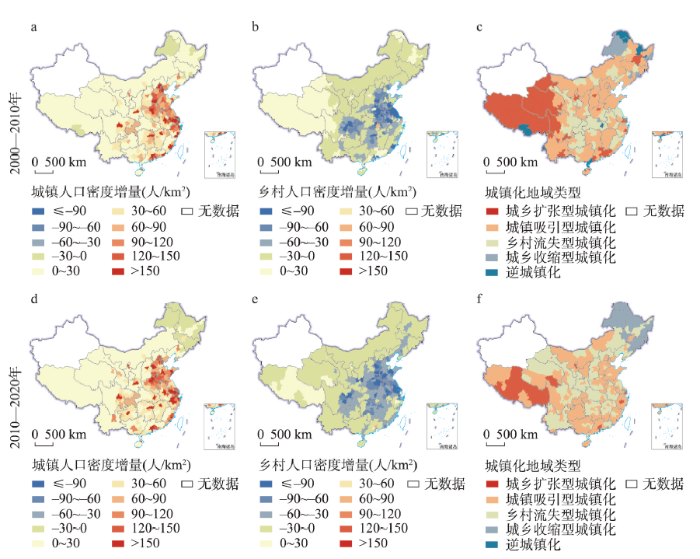
图4
2000—2020年中国各地级单元城乡人口变动及城镇化地域类型演变
注:基于自然资源部标准地图服务网站GS(2019)1823号标准地图制作,底图边界无修改。
Fig. 4
Urban-rural population change and regional types of urbanization at the prefecture level in China from 2000 to 2020
城镇吸引型和乡村流失型是最主要的城镇化地域类型,二者在空间上交错分布,在数量上此消彼长。2000—2010年城镇吸引型地域单元共190个,占全部分析单元的58.28%,广泛分布于东北、华北、华南以及云南等地;2010—2020年,伴随着辽宁、山西、陕西、湖南、江西和云南等地城镇人口增长放缓而乡村人口流失加剧,城镇吸引型地域单元数量减少至160个,占比减少至49.08%。与之相对的是,乡村流失型地域单元数量由2000—2010年的82个增加至2010—2020年的125个,占比由25.15%提升至38.34%,在北方的辽宁、山西和陕西,长江中下游的湖北、安徽、湖南、江西以及西南地区的云南等均存在较广泛的分布。
城乡扩张型和城乡收缩型地域单元占比一直不高,前者的空间范围大幅收缩,后者则在东北地区大范围扩张。城乡扩张型地域单元主要分布在青藏高原地区,2000—2010年、2010—2020年两个10年间,该类地级单元的占比由11.66%降低至4.29%。其中,以高生育率为主要特征的青藏高原连片地域随着人口转变而明显收缩,城市群和省会城市则因乡村人口由增转减而普遍转化为城镇吸引型城镇化。由于城镇人口减少的地区数量明显增加,城乡收缩型地域单元增加了3倍,占比由1.84%迅速提升至7.36%,新增单元主要位于东北地区,尤其是黑龙江和吉林的非省会城市。
上述空间差异与地市所属城市群类型和中心城市规模等级存在较强的关联。如图5所示,除东北城市群外,各城市群的城镇人口增长均超越了本地乡村人口流失,为城镇吸引型城镇化地域,但相比之下,东部城市群的城镇对区域外的人口吸引力最强。中心城市规模等级与城镇人口增加量存在明显的正相关关系,中小城市城镇人口增量较小,2010—2020年乡村人口的迅速流失使其城镇化的地域类型由城镇吸引型转变为乡村流失型;大城市和特大城市城镇人口增加量较大且乡村流失相对不多,维持了城镇吸引型城镇化;超大城市乡村人口止降回升,成为了城乡扩张型城镇化地域。
图5
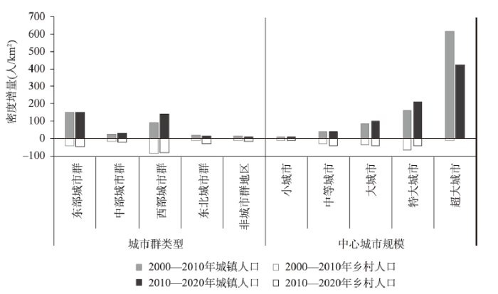
图5
2000—2020年中国城市群、中心城市规模等级与城乡人口变动
Fig. 5
Urban-rural population change in different urban agglomerations and different-sized cities in China
4 城镇化地域类型的影响因素
为探究城乡人口变动及城镇化地域类型的影响因素,分别采用多元线性回归模型和多项Logit模型开展回归分析。首先对变量进行共线性诊断和异方差性检验,各自变量的方差膨胀因子(VIF)均小于10,不存在严重的多重共线性问题,但White检验发现变量存在异方差性,因此在回归中采用稳健标准误以弱化异方差性的影响。表3报告了回归系数,结果显示自然地理、经济社会和政策环境因素对城乡人口变动和城镇化地域类型均存在影响,但正如预期,影响的方向和强度既存在共性和异质性,也随时间而演化。
表3 回归分析结果
Tab. 3
| 2000—2010年 | 2010—2020年 | ||||||||||
|---|---|---|---|---|---|---|---|---|---|---|---|
| 城镇人口 密度增量 | 乡村人口 密度增量 | 城镇化地域类型(参照组=城镇吸引型) | 城镇人口 密度增量 | 乡村人口 密度增量 | 城镇化地域类型(参照组=城镇吸引型) | ||||||
| 城乡扩张型 | 乡村流失型 | 城乡收缩型 | 城乡扩张型 | 乡村流失型 | 城乡收缩型 | ||||||
| 地形位指数 | 50.250*(30.16) | -10.544(13.53) | -0.502(1.90) | -2.293**(1.03) | -5.648**(2.62) | 16.650(23.00) | 21.121***(6.87) | 7.985**(3.99) | -1.643(1.17) | -7.957***(2.23) | |
| 多年平均气温 | 0.109(1.59) | 2.139**(0.86) | 0.025(0.10) | -0.120*(0.07) | -0.479(0.29) | 3.483**(1.52) | 0.188(0.46) | -0.014(0.15) | -0.073(0.07) | -0.836***(0.17) | |
| 多年平均降水 | 0.002(0.02) | -0.030***(0.01) | 0.000(0.00) | 0.002***(0.00) | 0.006(0.00) | -0.039**(0.02) | 0.010*(0.01) | 0.001(0.00) | -0.000(0.00) | 0.009***(0.00) | |
| 人均GDP增幅 | 0.066(0.04) | -0.086***(0.03) | -0.008*(0.00) | 0.001(0.00) | 0.001(0.00) | -0.016(0.05) | -0.101***(0.02) | -0.050**(0.02) | 0.014***(0.00) | -0.001(0.01) | |
| 二三产业增加值占比变动量 | -0.305(0.69) | 0.899**(0.42) | 0.120**(0.05) | -0.045(0.03) | 0.025(0.06) | 1.831*(0.93) | 0.694**(0.30) | 0.657***(0.19) | -0.170***(0.07) | -0.252**(0.11) | |
| 每万人医生数增幅 | 0.414*(0.22) | -0.260*(0.14) | -0.005(0.01) | 0.001(0.01) | 0.005(0.01) | 0.010(0.06) | 0.069**(0.03) | 0.009(0.01) | -0.007(0.01) | 0.005(0.01) | |
| 每万人中小学教师数增幅 | 0.404(0.40) | -0.511**(0.26) | 0.023(0.01) | 0.036***(0.01) | 0.010(0.02) | 0.092(0.20) | -0.184**(0.08) | 0.003(0.02) | -0.014(0.01) | -0.014(0.02) | |
| 城市群(参照组=非城市群地区) | |||||||||||
| 东部城市群 | 31.907(20.36) | -12.144(9.37) | -2.110(1.51) | -0.619(0.65) | -14.454***(1.32) | 28.336(19.60) | -13.297***(4.77) | 0.093(1.66) | -1.796***(0.64) | -16.210***(1.73) | |
| 中部城市群 | 8.163(10.28) | -1.979(6.66) | 0.256(1.09) | -0.868(0.55) | -14.179***(1.62) | 26.426*(14.65) | -15.937***(4.25) | -15.375***(1.91) | -0.391(0.48) | -16.384***(0.99) | |
| 西部城市群 | -17.887***(6.41) | -1.309(4.69) | -0.434(0.99) | 0.984**(0.41) | -12.803***(1.24) | 13.055*(7.49) | -4.474(3.14) | -0.822(1.39) | -0.516(0.43) | 2.130*(1.28) | |
| 东北城市群 | -6.978(14.98) | -12.077(9.54) | -1.368(1.23) | 0.587(0.74) | -1.266(1.02) | -31.164***(10.78) | -8.060**(3.25) | -17.005***(1.80) | 2.500***(0.94) | 1.985(1.36) | |
| 中心城市规模等级(参照组=小城市) | |||||||||||
| 中等城市 | -11.686(7.20) | 0.722(4.74) | -0.267(0.81) | 0.090(0.38) | 0.113(1.60) | -0.119(7.43) | -4.801(2.92) | 1.562(1.62) | 0.154(0.36) | -2.152**(1.06) | |
| 大城市 | 5.649(12.40) | -0.187(7.81) | 0.284(1.35) | -0.224(0.59) | 0.442(2.00) | 33.771***(12.31) | -1.745(4.01) | 0.855(1.74) | -1.581**(0.71) | -3.896***(1.34) | |
| 特大城市 | 79.521(79.70) | -71.599**(36.15) | -8.967(11.45) | 1.392(0.99) | -14.420***(3.06) | 62.917(81.17) | -19.393(15.42) | -1.301(4.59) | -18.273***(1.21) | -20.898***(2.08) | |
| 超大城市 | 64.187(147.91) | -21.214(50.15) | -12.267(14.15) | -6.394***(2.30) | -13.913(12.02) | -391.155**(164.64) | 5.715(25.20) | 1.685(2.60) | -16.326***(2.35) | -17.433***(5.36) | |
| 基期城镇人口密度 | 0.408***(0.13) | 0.055(0.05) | 0.017(0.01) | -0.012***(0.00) | 0.015(0.01) | 0.305***(0.06) | 0.046***(0.02) | 0.005***(0.00) | -0.004*(0.00) | 0.006**(0.00) | |
| 基期乡村人口密度 | 0.139***(0.05) | -0.277***(0.03) | -0.024**(0.01) | 0.005***(0.00) | -0.018(0.02) | -0.074(0.10) | -0.227***(0.02) | -0.024***(0.01) | 0.002(0.00) | -0.005(0.01) | |
注:括号内为稳健标准误;*p < 0.1,**p < 0.05,***p < 0.01,截距项回归结果略。
城乡人口变动与自然地理因素的关联性在很大程度上体现了西南地区的城镇化优势,气温较高、降水适度的高原山区城乡人口增量相对更大,驱动了城乡扩张或城镇吸引型城镇化。具体而言,地形位指数高的地区城镇人口增量更大,更容易成为城镇吸引型地域,2010—2020年间这些地区的乡村人口增长也显著快于其他地区,成为城乡扩张型地域的可能性增强。一般而言,地势低平、降水充沛的地区更加适宜人口生存和城镇发展,但在全国城镇化的中后期,这些地区大多已经结束了快速城镇化阶段,城镇人口增长明显减缓,部分地区反而由于便利的交通条件和大量的农业剩余劳动力而面临更严重的人口外流[10]。温暖的南方地区城乡人口增长均快于寒冷的北方地区,因而越不会成为城乡收缩型地域。气温的积极作用反映了中国人口尤其是城镇人口重心南移的趋势,但其更多地体现在降水量适中的西南地区,降水充沛的东南沿海地区城镇人口增长量相对更小。自然因素与城镇化的关联性一方面体现了城乡宜居性、交通便利性等对城乡人口变动及城镇化的直接影响,另一方面也反映了其他具有明显地域性因素的影响,尤以政策性因素最为突出,例如精准扶贫、乡村振兴等政策对西南地区人口发展和城镇化的积极影响均远高于其他地区。
经济性因素在城乡人口变动和城镇化发展中所发挥的作用是强烈而持续的,公共服务等社会性因素的影响相对有限。具体而言,经济快速增长主要通过加快乡村人口外流而驱动乡村流失型城镇化,这一作用在2010—2020年间更加突出。工业化能够有效促进城镇人口集聚、抑制乡村人口外流,促使地区经历城乡扩张型或城镇吸引型城镇化。工业化对城乡人口的共同积极影响反映了城市和乡村工业发展的良性互动,印证了产业振兴在乡村振兴和城乡协调发展中的关键作用。公共服务水平方面,仅每万人中小学教师数增幅在2000—2010年会促进乡村流失型城镇化,而每万人医生数增幅在两个时期对城镇化地域类型的影响均不明显。这些结果表明,当前中国的城镇化与经济发展转型的关系密切,工业化有利于城乡协调共进,公共服务等社会性因素尚未成为影响城乡人口和城镇化地域类型演变的主要原因。
政策环境因素方面,培育中西部城市群,促进大中小城市协调发展的政策导向效果相对有限。与非城市群地区相比,中部和西部城市群在2010—2020年经历了更大规模的城镇人口增长,但也面临更大规模的乡村人口减少,尽管这加快了城镇化速度,但与东部城市群相比,中西部城市群的城镇化仍更依赖于乡村人口流失而非城镇人口增长。各规模等级城市的城镇化地域类型在2010—2020年分化明显,随着中心城市规模等级的提高,地区成为乡村流失或城乡收缩型地域的可能性降低。东部城市群、大城市发育相对成熟,城镇对本地乡村人口和区域外人口均具有较强的吸引力,因而主要通过城镇人口的增加而实现城镇化水平提升;而西部城市群、中小城市处于发展的初中期,城镇对区域外人口的吸引力有限,甚至面临本地人口外流压力,城镇化率的提升更多地通过乡村人口减少来实现。这表明尽管各地城镇化水平普遍提升,但城镇对人口的吸引力差距突出,城镇化的实现方式和路径截然不同。
5 结论与讨论
本文从城乡人口变动的视角提出了城镇化地域类型划分的方法,基于历次人口普查数据,刻画了中国城镇化地域类型的时空演变特征并考察了其影响因素。研究发现:中国于1990年后进入城镇化快速阶段且当前仍在加速,但城镇化的实现方式存在较强的时空动态,主要表现为:① 全国尺度上,伴随着人口自然增长的下降和乡城迁移的扩张,城镇化地域类型从城乡扩张型转变为城镇吸引型,乡村人口减少对城镇化的贡献持续增强;② 省级尺度上,城镇吸引型始终是最主要的城镇化地域类型但空间范围不断调整,城乡扩张型地域的范围收缩至西藏和上海,乡村流失型地域最早出现在西南省份后期向北部转移,城乡收缩型地域首次出现在黑龙江;③ 地级尺度上,城镇吸引型和乡村流失型是最主要的城镇化地域类型,二者在空间上交错分布,在数量上此消彼长;城乡扩张型和城乡收缩型地域单元占比不高,前者的空间范围大幅收缩,后者则在东北非省会城市大范围扩张。
自然地理因素对城乡人口变动和城镇化地域类型形成了基础性的约束,二者在当前阶段的关联特征在很大程度上体现了西南地区的城镇化优势,即气温较高、降水适度的高原山区城镇人口增量更大,驱动了城乡扩张型或城镇吸引型城镇化。经济因素是城乡人口变动及城镇化地域类型的主要影响因素,当前中国的城镇化仍是典型的经济增长驱动型,工业化长期有利于城乡协调共进,但公共服务等社会性因素对城乡人口变动和城镇化地域类型的影响仍十分有限。培育中西部城市群,促进大中小城市协调发展,实现乡村振兴的政策效应还有待发掘:西部城市群、中小城市的城镇对人口的吸引力较东部城市群和大城市仍存在差距,其城镇化的实现更多地依赖于本地乡村人口减少;除超大和特大城市周边的乡村人口止降回升或降幅缩小以外,各类城市群和非城市群地区、各规模等级城市所在地的乡村人口都在加速流失,乡村振兴战略中的人口发展问题仍需要深刻反思和系统研究。
本文验证了既有研究中所发现的自然地理、经济社会和政策环境塑造城乡人口变动格局等结论,同时也获得了一些新的有益发现。① 城镇人口和乡村人口并非简单的此消彼长的关系,解析城乡人口变动与城镇化的关系对于深化城镇化机制的理解具有重要的理论意义。促进城镇人口增长的因素并不必然导致乡村人口减少,各因素通过对城镇和乡村人口分别施加影响而综合作用于城镇化进程,塑造了差异化的城镇化地域类型。② 城镇化是动态演变的,跨时序的跟踪研究对于研判城镇化的最新状况和未来趋势具有重要的现实意义。自然增长的下降和乡城迁移的扩张使得城镇人口加速集聚,乡村人口由增转减并加速流失,在这种“双加速”过程中,中国的城镇化经历了速度提升和类型转变。在人口转变的持续推进下,乡村人口减少对城镇化的贡献将进一步增强。③ 各地城镇化的地域类型存在差异,政策应对也应该各有侧重。大城市、东部城市群的城镇对本地乡村人口和区域外人口均具有较强的吸引力,主要通过城镇人口增加而实现城镇化;中小城市、西部和东北城市群的城镇化发展更多地依赖于乡村人口减少。从而前者应重视城镇建设用地、基础设施和公共服务供给能力的提升,后者需要加强对乡村空心化问题的应对。
参考文献
Assessment on the urbanization strategy in China: Achievements, challenges and reflections
DOI:10.1016/j.habitatint.2017.11.009 URL [本文引用: 1]
Patterns and driving mechanism of spatial agglomeration during the urbanization process in China
DOI:10.11821/dlyj201602003
[本文引用: 1]

Establishing a scientific and reasonable spatial pattern of urbanization, which has a significant meaning in improving the quality of urbanization and promoting the healthy development of urbanization, is the inherent requirement to advance a new type of urbanization. Based on statistical data and geographic information technology, the paper profoundly reveals the situation on spatial agglomeration during the urbanization process in China as well as the corresponding prominent contradiction, comprehensively examines the mechanism of the spatial agglomeration from the theoretical aspect, and briefly discusses the policy and suggestion of optimizing the spatial layout of urbanization. This paper argues that the spatial agglomeration during the urbanization process in China has been significant since the economic reforms and opening up policy initiated in 1978. Population, resources, elements and industries agglomerated in the eastern coastal area in large scale, forming several city clusters and densely inhabited regions. The spatial agglomeration of various elements was found to be related to many factors. To be specific, the regional difference in the natural background conditions and resources endowment is the fundamental condition while the east-oriented national development strategy and the agglomeration effect of the resource elements are the external conditions. However, the underlying impetus is increasingly widening development gap between regions. It should be noted that there is a certain historical inevitability for the agglomeration of population and industry in the eastern region. However, the scale and speed of the spatial agglomeration in relation to population and industry failed to be consistent, which result in two unharmonious problems—the mismatch of the spatial distribution of population and industry as well as the mismatch of the spatial distribution of population, industry, resources and environment. These two inharmonious problems have caused several prominent problems such as the transfer of hundreds of millions of "amphibious migratory" type of migrant workers, the cross-regional flow of energy and bulk commodities, the tremendous pressure of resources and environment in the eastern region, and the increasingly intensified instability factors and social contradictions. The essence to establish an efficient, balanced and safe spatial pattern of urbanization is to realize a regional harmonious development, not only emphasizing people's prosperity, but also highlighting the regional prosperity. There are two core strategies—"industry shift to the west" and "population shift to the east"—launched to optimize the spatial layout of urbanization.
中国城镇化进程中的空间集聚、机理及其科学问题
DOI:10.11821/dlyj201602003
[本文引用: 1]
构建科学合理的城镇化空间格局,是推进新型城镇化的内在要求,对提升城镇化质量和推动城镇化健康发展具有重要意义。基于统计数据和地理信息技术,深刻揭示了中国城镇化进程中的空间集聚态势及其造成的突出矛盾,从理论视角综合考察了城镇化进程中的空间集聚形成机理,并简要探讨了优化城镇化空间格局的政策建议。研究表明,改革开放以来中国城镇化进程中的空间集聚态势十分明显,人口、资源、要素和产业大规模向东部沿海地区集聚,并在空间上形成了若干个城市和人口密集区。造成这种空间集聚态势的因素是多方面的,自然本底条件和资源禀赋的地带性差异起到基础性作用,国家发展战略的东部偏向及资源要素的空间集聚效应是外部条件,而更深层次的基本动力源于区域之间日益拉大的发展差距。应该看到,改革开放以来中国人口与产业向东部地区集聚具有一定的历史必然性,但二者的空间集聚未能协同一致,由此导致两个“不协调”,即人口分布与产业及就业岗位分布的不协调及人口、经济分布与资源环境承载能力的不协调。这两个“不协调”造成了数以亿计的“两栖”农民工跨区域迁移、能源与大宗商品的跨区域流动、局部地区资源环境面临巨大压力、不稳定因素和社会矛盾日益激化等突出问题。要构建高效、均衡、安全的城镇化空间格局,其本质就是要实现区域协调发展,即不单纯要强调人的繁荣,还要强调地域的繁荣。“产业西进”和“人口东移”是优化中国城镇化空间格局和形态的战略重点。
Polarization trend and optimization of size distribution in China's urbanization process
中国城镇化进程中两极化倾向与规模格局重构
Spatial patterns and determinants of urbanization in China
Using the sixth national population census data ,this paper examines spatial relationship and patterns of China ’s urbanization by Exploratory? Spatial Data Analysis. Spatial autocorrelation of urbaniza- tion is a main factor causing spatial? differences of urbanization which also moderates the impacts of other factors affecting urbanization. Using spatial error model which controls spatial autocorrelation for regression analysis ,we find that regional differences in land urbanization ,employment and output in the secondary and tertiary sectors ,and GDP per capita largely determines spatial? differences and patterns of urbanization. An increased level of employment of the tertiary sector has a larger effect in Central than in East China. Unlike some previous studies ,when controlling for major factors ,we find regional financial expenditure ,export , development of Hong Kong ,Macao and Taiwan - funded enterprises? and foreign - funded enterprises have not had significant impact on regional patterns of urbanization.
中国人口城镇化的空间差异与影响因素
中国人口城镇化水平存在明显的空间差异,呈现出"东高西低"的格局。文章根据第六次全国人口普查数据,运用探索性空间分析方法对中国人口城镇化的空间关系进行了分析。研究发现,人口城镇化水平的空间正自相关性是造成中国人口城镇化空间差异的一个主要原因,并且会改变其他因素对人口城镇化的影响。利用控制了空间自相关性的空间误差模型进行回归分析发现,地区之间土地城镇化水平、第二、三产业就业水平和产值水平,以及人均GDP的差距是造成人口城镇化水平空间差异的主要原因,并且第三产业就业水平的提升对中西部地区人口城镇化的促进作用大于其在东部的作用。与一些研究文献的结论不同,本文在控制主要因素后发现,财政支出水平、出口规模、港澳台资和外资企业发展水平对人口城镇化的空间差异影响并不显著。
Shrinking cities: Misunderstandings, identifications and reflections
DOI:10.11821/dlyj020200359
[本文引用: 1]
While China′s urbanization has been characterized by 'growth-oriented' development models, the recent literature has highlighted the emergence of urban shrinkage in China, i.e., cities and regions that endure sustained population losses. This is especially the case for some resource-based cities in Northeast and North China, which have been losing their population and suffering from stagnant and even negative local GDP growth. Shrinking cities is a new phenomenon for research in the areas of population-resources-environments, spatial planning and urban governance in China. Based on a brief review of related literature, this paper summarizes some misunderstandings in the research of shrinking cities in China. It is a challenge to identify shrinking cities scientifically because of different demographies, different classification standards and disconnection between attributes data and geographic units. Extending from the suggestion from Zhou and Shi (1995), this paper, based on urban physical areas comparison and urban administrative areas test, analyzes the changes of China′s urban population and proposes a framework to identify the shrinking cities. The results show that there are 114 designated cities, in which the population size of the "Chengrenkou" (residential population in the built-up area) in 2010 was smaller than that of the "Shirenkou" (residential population in the administrative area) in 2000. However, due to a larger "Shirenkou" size in 2000 in statistics than in actual situation, and also several inflated figures of "Chengrenkou" in 2010, the exact number of "shrinking cities" is less than 114. After excluding "urban administrative areas" with a larger rural population, 56 cities and 75 cities were in net outflow in 2000 and 2010, respectively. The results are highly policy-relevant, therefore we should adjust future policies regarding urban shrinkage management. Finally, this paper argues that China should establish the concept of urban physical areas and promote the regional collaborative statistical system of urbanization. And it is also necessary to build a "spatio-temporal aligned" geographic information system database of China's resident population and take the regional differences in the administrative divisions into account in order to continuously promote the accurate division of urban and rural population.
收缩型城市: 认知误区、统计甄别与测算反思
DOI:10.11821/dlyj020200359
[本文引用: 1]
收缩型城市是中国城镇化、空间规划与城市治理的全新命题。论文在简要梳理收缩型城市相关文献的基础上总结了当前收缩型城市研究在中国的认知误区。因人口统计口径不一致、划分标准不可比、数量属性与地域空间脱节等原因给科学清晰的识别收缩型城市提出了挑战。在周一星、史育龙(1995)建议的基础上,论文提出了基于实体地域对比与行政地域互验来分析全国城市人口的增减变化及收缩型城市的甄别框架,测算表明:全国有114个建制市2010年的“城人口”规模低于2000年“市人口”规模,但由于2000年“市人口”的偏大统计以及2010年“城人口”存在的“个别水分”,这些城市也未必就全是“收缩型城市”;在剔除乡村人口较高的“城市型政区”后,全国2000年和2010年人口处于净流出状态的建制市分别为56个和75个。论文认为:中国应尽快建立城市实体地域概念,推进城市化区域协同统计制度;要构建“时空对齐”的全国常住人口地理信息系统数据库并综合考虑各地行政区划建制差异,持续推进城乡人口的精准划分。
Research on the urban-rural integration and rural revitalization in the new era in China
DOI:10.11821/dlxb201804004
[本文引用: 1]
Cities and villages are components of a specific organism. Only the sustainable development of two parts can support the prosperous development as a whole. According to the theory of man-earth areal system, urban-rural integrated system and rural regional system are the theoretical bases for entirely recognizing and understanding urban-rural relationship. To handle the increasingly severe problems of "rural disease" in rapid urbanization, accelerating rural revitalization in an all-round way is not only a major strategic plan for promoting the urban-rural integration and rural sustainable development, but also a necessary requirement for solving the issues related to agriculture, rural areas, and rural people in the new era and securing a decisive victory in building a moderately prosperous society in all respects. This study explores the basic theories of urban-rural integration and rural revitalization and analyzes the main problems and causes of rural development in the new era, proposing problem-oriented scientific approaches and frontier research fields of urban-rural integration and rural revitalization in China. Results show that the objects of urban-rural integration and rural revitalization is a regional multi-body system, which mainly includes urban-rural integration, rural complex, village-town organism, and housing-industry symbiosis. Rural revitalization focuses on promoting the reconstruction of urban-rural integration system and constructs a multi-level goal system including urban-rural infrastructure networks, zones of rural development, fields of village-town space and poles of rural revitalization. Currently, the rural development is facing the five problems: high-speed non-agricultural transformation of agriculture production factors, over-fast aging and weakening of rural subjects, increasingly hollowing and abandoning of rural construction land, severe fouling of rural soil and water environment and deep pauperization of rural poverty-stricken areas. The countryside is an important basis for the socioeconomic development in China, and the strategies of urban-rural integration and rural revitalization are complementary. The rural revitalization focuses on establishing the institutional mechanism for integrated urban-rural development and constructs the comprehensive development system of rural regional system, which includes transformation, reconstruction and innovation in accordance with the requirements of thriving businesses, pleasant living environments, social etiquette and civility, effective governance, and prosperity. Geographical research on rural revitalization should focus on the complexity and dynamics of rural regional system and explore new schemes, models and scientific approaches for the construction of villages and towns, which are guided by radical cure of "rural disease", implement the strategy of rural revitalization polarization, construct the evaluation index system and planning system of rural revitalization, thus providing advanced theoretical references for realizing the revitalization of China's rural areas in the new era.
中国新时代城乡融合与乡村振兴
DOI:10.11821/dlxb201804004
[本文引用: 1]
城市与乡村是一个有机体,只有二者可持续发展,才能相互支撑。依据人地关系地域系统学说,城乡融合系统、乡村地域系统是全新认知和理解城乡关系的理论依据。针对日益严峻的“乡村病”问题,全面实施乡村振兴,既是推进城乡融合与乡村持续发展的重大战略,也是破解“三农”问题,决胜全面建成小康社会的必然要求。本文探讨了新时代城乡融合与乡村振兴的基础理论,剖析了乡村发展面临的主要问题,提出了问题导向的中国城乡融合与乡村振兴科学途径及研究前沿领域。结果表明:① 城乡融合与乡村振兴的对象是一个乡村地域多体系统,包括城乡融合体、乡村综合体、村镇有机体、居业协同体,乡村振兴重在推进城乡融合系统优化重构,加快建设城乡基础网、乡村发展区、村镇空间场、乡村振兴极等所构成的多级目标体系。② 中国“三农”问题本质上是一个乡村地域系统可持续发展问题,当前乡村发展正面临主要农业生产要素高速非农化、农村社会主体过快老弱化、村庄建设用地日益空废化、农村水土环境严重污损化和乡村贫困片区深度贫困化等“五化”难题。③ 乡村是经济社会发展的重要基础,城乡融合与乡村振兴战略相辅相成,乡村振兴应致力于创建城乡融合体制机制,推进乡村极化发展,按照产业兴旺、生态宜居、乡风文明、治理有效、生活富裕的要求,构建乡村地域系统转型—重构—创新发展综合体系。④ 乡村振兴地理学研究应着眼于乡村地域系统的复杂性、综合性、动态性,探究以根治“乡村病”为导向的新型村镇建设方案、模式和科学途径,为实现新时代中国乡村振兴战略提供理论参考。
Important progress and prospects of China's urbanization and urban agglomeration in the past 40 years of reform and opening-up
DOI:10.2307/142321 URL [本文引用: 2]
改革开放40年来中国城镇化与城市群取得的重要进展与展望
Spatial pattern and influencing factors of urbanization development in China at county level: A quantitative analysis based on 2000 and 2010 census data
中国县域城镇化发展格局及其影响因素: 基于2000和2010年全国人口普查分县数据
DOI:10.11821/dlxb201604007
[本文引用: 3]
利用2000 和2010 年中国人口普查分县数据,借助空间分析方法揭示近期中国常住人口城镇化格局特征及其动态变化,结合多元回归模型探讨城镇化空间分异的主要影响因素,基于主成分分析和聚类分析进行中国城镇化发展类型区划分。结果表明:① 2000-2010 年,中国常住人口城镇化率不断提高,年均增加1.3 个百分点,32%的县域城镇化水平年均增长超过1.5 个百分点;② 中国城镇化发展存在区域差异性和“低快高慢”的收敛性,东部、东北、中部、西部四大区域城镇化率年均分别增加1.4、0.5、1.4 和1.3 个百分点;③ 60%的中国县域城镇化发展集中在低城镇化率—高增长率、低城镇化率—中高增长率和低城镇化率—中增长率三种类型,且以中、西部地区分布最为密集;④ 中国县域城镇化格局基本未变,仍以珠三角、长三角、京津冀三大增长极的城镇化发展较为突出,东部地区及内陆省会城市周边的城镇化水平也相对较高;⑤ 经济发展水平、产业结构特征、人力资本状况、人口集聚能力、公共服务水平、地理区位特征对县域城镇化空间分异具有显著而稳健的影响;⑥ 中国城镇化格局可分为具有明显区类一致性和区外异质性的5 大类、20 个区域。新时期的城镇化发展应凸显地域功能、提升承载能力、夯实产业基础、强调节约集约。
Spatial-temporal pattern and driving forces of urbanization at county level in Beijing-Tianjin-Hebei megacity region
Based on the 2000 and 2010 census data of Beijing-Tianjin-Hebei megacity regionthis paper uses the ESDA method to analyze the spatial pattern of urbanization rates as well as its changes at county level By applying Spatial Error Model and GWR method both global and local driving forces of urbanization are investigated in this region The main results are as follows The urbanization rate of Beijing-Tianjin-Hebei megacity region at county level manifests a significant pattern of spatial aggregation which is gradually strengthened The increase of urbanization rate shows a pattern of convergence and areas where the urbanization rate is high have positive impact on the nearby areas where the urbanization rate is low For areas where the urbanization rate is increased the distribution of high value of rural contribution share is similar to that of areas which are in low urbanization rate Economic level industrial structure medical and education level and terrain condition have significant effects on the urbanization level of Beijing-Tianjin-Hebei megacity region Each driving force has a unique distribution of incidence pattern for different areas.
京津冀县域人口城镇化时空格局及驱动力研究
文章基于 2000 年和2010年中国人口普查的分县数据采用方法分析京津冀地区县域城镇化率的空间格局分布及变动情况提出城镇化率变动分城乡贡献度指标并就京津冀地区进行研究采取空间误差模型与的方法分别考察该地区城镇化全局和局部的驱动力状况结果表明京津冀地区的县域城镇化率表现出显著的空间集聚并且有逐渐加强的趋势城镇化率提高过程呈现收敛模式高城镇化率地区对于周边城镇化率过低的地区具有带动作用对于城镇化率提高的地区其增量中乡村贡献度的高值分布与城镇化程度低的一些地区重合经济水平产业结构医教水平和地形因素对京津冀地区城镇化影响显著。
Spatial-temporal evolution of rural population outflow and its mechanism in China
DOI:10.13249/j.cnki.sgs.2020.01.007
[本文引用: 2]
Human is the key to social and economic development, and plays a decisive role in rural evolution. However, influenced by urban-rural dual structure, there are large population outflow in rural China, which makes the strategy of rural revitalization lack of human capital support. Therefore, to scientifically promote the implementation of rural revitalization in the new era, it is necessary to study the rural population outflow. Using datasets of 2000 and 2010 population census of the People's Republic of China by county, this research analyzed the evolution and spatial pattern of rural population outflow in China. Then it explored the mechanism of regional differentiation of outflow rate of rural population (ORRP), which was reflected by the ratio of rural hukou-registered population and rural residential population. Results showed that the development of rural population in China from 1978 to present could be divided into three stages i.e., slow development stage (1978-1995), massive outflow stage (1995-2014) and citizenship of agricultural transfer population (since 2014). From 2000 to 2010, ORRP at county level in China generally showed an upward trend, the centralization of rural hukou-registered and residential population declined obviously. From the perspective of spatial pattern, they all showed significant spatial clustering and positive spatial correlation. In 2000, there were 76.06% counties with ORRP ranging from 100% to 150%, and only 14.01% of the counties' ORRP were less than 100%, which were mainly located in Qinghai-Tibet Plateau, Xinjiang and the border areas of northeast China. By 2010, the proportion of counties with ORRP less than 100% fell to 5.20%, concentrating in Xinjiang, and there were also a few counties in Qinghai-Tibet Plateau and Northeast China. Based on pre-selected influencing factors, estimated results of spatial error model (SEM) indicated that elevation, per capita GDP, urban-rural income ratio, proportion of primary industry, urbanization rate, road density, educational attainment and per capita investment in fixed assets were positively correlated with ORRP at county level, while per capita farmland, per capita net income of rural households and ratio of rural employees showed a negative correlation.
中国农村人口外流的时空演化及其驱动机制
DOI:10.13249/j.cnki.sgs.2020.01.007
[本文引用: 2]
以农村户籍人口和常住人口及两者表征的农村人口外流率为研究对象,利用“五普”和“六普”数据探讨了中国农村人口外流的演化及其空间格局,在预选取影响因素的基础上,基于空间计量模型剖析了县域农村人口外流率的地域分异机制。结果显示:农村人口发展演化可划分为缓慢发展阶段、大量外流阶段、农业转移人口市民化发展阶段3个时期;全国县域农村人口外流率呈现出程度不断加深的态势,农业户籍人口和乡村常住人口的集中度下降明显,并呈现出明显的空间聚类和空间正相关性;平均海拔、人均GDP、城乡居民收入比、第一产业占比、城镇化率、道路密度、受教育水平、人均固定资产投资与农村人口外流率呈现出正相关关系,而人均耕地面积、农民人均纯收入、乡村从业人员占比与农村人口外流率呈现出负相关关系。
Regional differentiation and coordinated development strategy of China's urbanization
我国城市化发展的区域差异及协调发展对策
An analysis on the padlock shape of China's urban population growth in the past ten years and its implication
中国近十年城镇人口增长的“挂锁”态势分析及启示
Mismatch distribution of population and industry in China: Pattern, problems and driving factors
DOI:10.1016/j.apgeog.2018.05.021 URL [本文引用: 1]
Geographic determinants of China's urbanization
DOI:10.1016/j.regsciurbeco.2016.05.001 URL [本文引用: 1]
Increasing internal migration in China from 1985 to 2005: Institutional versus economic drivers
Modelling skilled and less-skilled internal migrations in China, 2010-2015: Application of an eigenvector spatial filtering hurdle gravity approach
Provincial variation of urbanization in China
DOI:10.11821/xb198601002
[本文引用: 1]
China’s cities belong to the clustered pattern, examining them by Kolmogorov-Ami-nov formula and the Lorenz curve. The highest density of cities and towns has happened in Shanghai municipality: 56.77 cities and towns per 10,000 km<sup>2</sup>. Zhejiang and Jiangsu Provinces occupy second and third places, according to the density of urban settlements: 17.06 and 11.67 cities and towns per 10,000 km<sup>2</sup> respectively. The lowest density indexes of cities and towns are found in Xizang Autonomous Region and Qinghai: 0.08 and 0.12 respectively, the density of cities and towns is regularly reducing from East to West in China. The provincial variation of the density of cities and towns can be explained by the regression techniques. A correlation coefficient of 0.87 has been obtained by the regression analysis of the density of cities and towns, in which the population density as independent variable. In provinces and autonomous regions, the greater the population density, the greater the density of cities and towns. A multiple correlation coefficient is 0.96, which was found by multiple regression analysis of the density of urban settlements with the gross industrial and agricultural output value, per capita industrial output, the index of the railway length, per rural person grain output, and population density as independent variables. These five variables can explain 92% of the provincial variation of the density of urban settlements.Because the urbanization is measured by the proportion of urban population to the Provincial total ones, the urbanization level of those provinces with concentration of unban settlements and urban population seems to be not so high. Mostof the relatively high urbanized provinces and autonomous regions are located in Northeast, North and Northwest China, while the provinces with moderate and lower urbanization level are found in the East, Central and South provinces. Variables of population density, size of area, and industrial-agricultural output ratio, per capita industrial output, per capita agricultural output, per capita total production output can be used a for reflection of provinces’ population and economic characteristics respectively. Two factors are identified by factor analysis "with varimax rotation. The first factor is industrialization that measures the levels of industrialization and productivity and the second faetor-ispoptulation density that reflects the general population distribution characteristics of a province or an autonomous region. As these two factors are orthogonal each other, it suggests that there is not direct relationship between the industrialisation level with population size or density in every province or aut. region. A multiple correlation coefficient of 0.863 has been obtained by multiple regression analysis between urbanization level with the factor scores of industrialization level and population density as independent variables. These two factors could explain 74.5% of the provincial variation of urbanization level. The urbanization level of a province oir an autonomous region is related positively with industrialization level but negatively with population density. The industrial distribution policy encourages urbanization for the less densely populated Northeast, North and Northwest provinces and autonomous regions. To a certain extent, the control of urban population discourages urbanization for the densely populated East.There is big variation in the primacy index of the provinces in China. It ranges from 1,009 in Auhui to 10.23 in Qinghai (in 1982). The provinces and autonomous regions with high primacy index are mainly concentrated in the Northwest and Southwest regions of China, except Guangdong an Hubei provinces. The indexes of provinces and aut. regions in West China have increased since liberation, but in recent years, they have begun to fall in some provinces and autonomous regions. Most of the Northeast, East, North, and Central South provinces have moderate or low primacy indexes, which have declined since liberation. The provincial variation of the
我国城市化的省际差异
DOI:10.11821/xb198601002
[本文引用: 1]
解放以来,我国城市化水平有了一定的提高,但仍然较低。1982年底市镇总人口21 154万,占全国总人口的20%。但其中包括了近三分之一的农业人口,如以市镇总人口中的非农业人口计,约占全国总人口的14.2%。我国城市化水平不仅比发达国家低,而且也比一般发展中国家低。
Urban‐to‐rural population growth linkages: Evidence from OECD TL3 regions
DOI:10.1111/jors.12236 URL [本文引用: 1]
Research on the current situation of population mobility in China and its impact
当前我国人口流动形势及其影响研究
The differences of urban-rural population change and the underlying mechanism in the population shrinking counties in China
DOI:10.13249/j.cnki.sgs.2021.07.002
[本文引用: 1]
In recent years, the continuous decline of the total population at the regional scale has become increasingly obvious. Considering that most regions have still been experiencing the rapid urbanization processes, it is necessary to analyze the differences of urban and rural population changes and its underlying driving forces in the population shrinking areas. Based on the population census data in 2000 and 2010, this article has analyzed the difference characteristics of urban-rural population change in the population shrinking counties by identifying several urban-rural differentiation types, and then we have established a theoretical framework to investigate the underlying drivers. The main findings are as follows: 1) 38.6% of the research samples have experienced population shrinkage in the period from 2000 to 2010, but most of them have been characterized by “urban population increasing and rural population declining” (or “urban growth and rural decline” for short), and these units account for 89.5% of all the shrinking samples, and the proportion of urban-rural population both shrinking type (or “urban and rural both decline” for short) has a relatively low percentage. 2) In the central region, the type of “urban growth and rural decline A”, which means a high urban growth rate, occupies the main part, and Northeast China has a high percentage of the type of “urban and rural both decline”, and there are obvious spatial differentiations in the eastern and western China. 3) The factors of urbanization level and economic development level have the most significant impacts on the differentiation of urban-rural population change among the population shrinking areas: the population shrinking areas with higher urbanization level and lower economic development level will be more likely to experience slow urban population growth and even urban population decline. 4) The growth rate of economic development, the level of natural population growth, and the quality of public services also have certain impacts on the differentiation of urban-rural population change among the population shrinking areas. Based on these findings, we argue that the perspective of urban-rural differentiation can deepen understanding of population shrinkage in China, and it can also contribute to the relevant theories of population shrinkage in a developing context.
中国人口收缩的城乡分异特征及形成机理
DOI:10.13249/j.cnki.sgs.2021.07.002
[本文引用: 1]
在县市尺度上对2000—2010年人口收缩区的城乡分异特征进行分析,划分出城增乡减型、城乡双收缩型和城减乡增型等类型,并建立人口收缩城乡分异的理论分析框架,探讨了不同类型的形成机理,主要的发现如下:① 2000—2010年,人口收缩单元占比约为38.6%,城增乡减型单元占据绝对主体,达到34.5%,而“城乡双收缩型”和“城减乡增型”单元占比均较低。② 中部地区人口收缩区城镇人口增长普遍较快,东北地区城乡双收缩的特征较为突出,而东部和西部地区存在较明显的空间分异。③ 城镇化水平和经济发展水平对人口收缩城乡分异特征的影响最为显著,城镇化水平较高而经济发展水平较低的人口收缩区越可能出现城镇人口增长缓慢甚至城乡双收缩。④ 经济发展速度、人口自然增长水平、公共服务等因素对人口收缩城乡分异特征也存在一定的影响。
A literature review of the study on return floating population in China
中国城乡流动人口“回流”研究进展与述评
Urban agglomeration: An evolving concept of an emerging phenomenon
DOI:10.1016/j.landurbplan.2017.02.014 URL [本文引用: 1]
Spatial rebalancing and industrial convergence in China
DOI:10.1016/j.chieco.2015.03.007 URL [本文引用: 1]
Spatial differentiation and influencing mechanism of nearby urbanization in central and western China
DOI:10.11821/dlxb202112009
[本文引用: 1]
Considering the new-type urbanization background, the nearby urbanization model provides a practical approach toward eliminating the disadvantage of trans-regional urbanization and promoting urbanization. This study establishes the indexes of the nearby urbanization rate (NU), contribution to nearby urbanization (CNU) and trend of contribution to nearby urbanization (TNU), to analyze the spatial differentiation features of nearby urbanization in central and western China from 2000 to 2015. Moreover, this study explores the determinant factors and influencing mechanism of the spatial differentiation of nearby urbanization in the study region. Results show that: (1) From 2000 to 2015, the population of nearby urbanization increased from 196 million to 347 million and the NU increased from 28.16% to 46.89%. (2) Based on the analysis of the CNU, we found that the main source of nearby urbanization was the population registered in the local town, but the contribution of local town to nearby urbanization (CNUt) gradually declined over the study period. The areas with high CNUt were widely distributed in central and western China in 2000, but by 2015, they were restricted to Sichuan province. Meanwhile, the contribution of local county to nearby urbanization (CNUc) increased and the contribution of local province to nearby urbanization (CNUp) varied slightly. Most areas with high CNUp were provincial capital cities, resource-based cities or pastural cities. (3) Based on the analysis of the TNU, the trend of the contribution of local county to nearby urbanization (TNUc) exceeded the trend of the contribution of local province to nearby urbanization (TNUp), while the trend of the contribution of local town to nearby urbanization (TNUt) exhibited the least influence. Therefore, examining nearby urbanization based on the county-level spatial unit was advantageous in most regions; however, in the northwestern border regions and provincial capital cities, the provincial level was more applicable. (4) The spatial differentiation of nearby urbanization was determined based on the integrated results of various influencing factors, including natural environment, economic development, non-agricultural industries, urban public services, transportation accessibility, and the influence of local administration.
中国中西部地区就近城镇化空间分异格局及机理
DOI:10.11821/dlxb202112009
[本文引用: 1]
就近城镇化是中国中西部地区破除异地城镇化模式弊端、推进新型城镇化健康发展的现实路径选择。通过构建就近城镇化率、贡献力和贡献势指标,从本省、本县和本镇3个城镇化尺度,系统分析2000—2015年中国中西部地区就近城镇化空间分异特征,并深入剖析其驱动机制。研究发现:① 2000—2015年中西部地区就近城镇人口总数从1.96亿增加到3.47亿,就近城镇化率从28.16%上升到46.89%。② 从贡献力看,中西部地区就近城镇化的主要来源是本镇户籍人口,但本镇贡献力呈下降趋势,本县贡献力波动上升,本省贡献力变化不大。③ 从贡献势看,本县贡献势>本省贡献势>本镇贡献势,县域尺度是中西部大部分地区就近城镇化的优势空间单元。④ 中西部地区就近城镇化空间分异是自然环境背景、经济增长和非农产业发展、城市公共服务供给、交通运输条件和地方行政力量等多重因素的综合作用结果。
Changes in the form of population migration and mobility in China and corresponding policy responses at the late-intermediate stage of urbanization
DOI:10.18306/dlkxjz.2020.12.008
[本文引用: 1]
The form of population migration and mobility constitutes a key element of the characteristics of migration. Since China has entered the late-intermediate stage of urbanization, it is very important to accurately identify and understand the transformation in the form of population migration and mobility. While a growing body of literature has been generated and significant progress has been made on China's population migration and mobility and its determinants, an important inadequacy of relevant research are often focused on rural to urban population migration and mobility, neglecting the multi-dimensional forms of population migration and mobility. Based on relevant theories and international experience relating to the transformation in the forms of population migration and mobility, and using data from the China Migrants Dynamic Survey (CMDS), Report on Monitoring and Investigation of Migrant Workers in China, and relevant statistics, this study examined the processes of the transformation in the forms of the population migration and mobility in China and their characteristics at the present stage and the issues and challenges arising therefrom. The results show that there have been significant changes in the forms of population migration and mobility in China, and such changes mainly manifest in the following aspects: First, there has been a steady increase in return migration and short-distance migration; Second, inter-urban migration has also significantly increased and become increasingly common; Third, the urbanization process of the floating population based on the rural-urban transfer of their hukou has started to accelerate, and their rural-urban multiple livelihoods has increasingly shifted towards the urban end; Fourth, there has been a developing trend of urbanization driven by housing purchases in both migrants' places of origin and destination. The study also identified issues and challenges in the process of transformation in the forms of population migration and mobility, including: First, there is a lack of sustainability in in situ urbanization promoted by return migration; Second, urban-urban migration are highly concentrated in a few provinces of the eastern region; Third, there are still many obstacles for the urbanization of rural migrants based on their hukou transfer. Finally, the article puts forward some policy recommendations from the perspectives of the construction of multi-level spatial system of urbanization of the floating population, the transformation of urban governance mode, and the promotion of the capacity for sustainable development of small towns in central and western regions.
城镇化中后期中国人口迁移流动形式的转变及政策应对
DOI:10.18306/dlkxjz.2020.12.008
[本文引用: 1]
人口迁移流动形式是构成人口迁移流动特征的一个关键要素。在中国进入人口城镇化中后期后,准确判断和把握人口迁移流动形式的转变是一项十分重要的工作。论文基于人口迁移流动形式转变的相关理论与国际经验,考察现阶段中国人口迁移流动形式转变的进程和特点及由此产生的问题与挑战。研究发现,中国人口迁移流动形式已发生转变,并突出表现为人口回流现象不断增多、省际和省内人口迁移流动此消彼长的趋势日益明显;城—城流动显著增加,人口的城-城间流动将渐成常态化;流动人口户籍城镇化进程开始加快,其城乡两栖生计的重心向城镇转移;住房驱动下的流动人口就地、异地城镇化渐成趋势等。同时,人口迁移流动形式转变过程中面临着人口回流推动的就近就地城镇化发展可持续性不足;城—城流动向东部少数省市聚集的态势明显;以户籍城镇化主导的农业流动人口市民化面临多重障碍等问题与挑战。最后,从流动人口城镇化的空间载体构建、城市治理方式转变、中西部小城镇自我可持续发展能力提升等方面提出相应的建议。
Spatio-temporal evolution of migration in China from 1995 to 2015
DOI:10.11821/dlxb202202010
[本文引用: 1]
Based on the data of usual residence from 2000 and 2010 censuses and 1995 and 2015 micro-censuses and using the method proposed by Abel G. J., this paper estimates the O-D migration flows among prefectural-level administrative units in China for the period 1995-2015. By using the indicators of migration flows and migration rates, and the methods of GIS spatial analysis and community detection in social network analysis, it further reveals the characteristics of spatio-temporal evolution of migration in China since 1995. The results can be summarized as follows. (1) The scale and intensity of migration in China have been increasing, while their differences among regions have been gradually decreasing. This suggests that migration has experienced a gradual transformation from a "low-activity era" including a limited number of regions to a "high-activity era" involving the majority of regions. (2) Six regional types of migration among prefectural-level administrative units, namely, large-scale active net in-migration, small-scale net in-migration, large-scale active net out-migration, small-scale active net out-migration, active balanced migration and inactive migration, are identified. The spatio-temporal evolution characteristics of the regional types of migration in China indicate that each active migration regional type has been undergoing a change of continuous diffusion, while the inactive migration regional type has seen a significant reduction over time. (3) The spatial patterns of migration are quite different between regions on both sides of "Hu Line", manifested in the fact that the scale and intensity of migration flows on the southeastern side of the line is higher than that on the northwestern side, which means that the "Hu Line" is quite stable and robust in the last 20 years. (4) Patterns of migration flows indicate that while intra-provincial migration has continuously strengthened, inter-provincial migration has exhibited more complicated spatial patterns, mainly reflected in different changing trends of attractiveness to migrants among the three coastal city clusters, and the increasing migration flows within southwest China. As a result of combined effects of inter- and intra-provincial migration flows, the structure of migration flows in China's eastern, central and western regions has been undergoing changes, resulting in the internal differentiation of urban agglomerations and the declining spatial scope under their influence in the coastal areas, Hubei as the single independent "city community" in central China, as well as the relative stability in northwest China and continuous change in southwest China.
1995—2015年中国人口迁移的时空变化特征
DOI:10.11821/dlxb202202010
[本文引用: 1]
本文利用人口普查数据,估算了1995—2015年中国地(市)间人口O-D迁移流和迁移率,结合GIS空间分析和社会网络分析方法,揭示了20年间中国人口迁移的时空变化特征。研究发现:① 中国人口迁移由相对不活跃、局部地区参与的“低活性时代”,逐步走向相对活跃、绝大多数地区参与的“高活性时代”。② 人口迁移地域类型的时空演化过程呈现出各活跃型地(市)不断扩散,而非活跃型地(市)大幅缩减的特点。③ 人口迁移网络以“胡焕庸线”为界,东、西两侧迁移流“东密西疏”且差异悬殊,这一空间格局具有很强的稳定性和顽健性。④ 在人口省内迁移持续增强,以及跨省迁移中沿海三大城市群吸引力的“此消彼长”和西南地区吸引力不断增强的背景下,东中西部地区的人口迁移流场结构表现为:沿海地区主要城市群内部分化和影响范围减弱,中部地区(除湖北省)未能演化出以省为单元的独立社区,西部地区则是西北相对稳定而西南持续变动。
How multi-proximity affects destination choice in onward migration: A nested logit model
DOI:10.11821/dlxb202012012
[本文引用: 1]
China's migrant population continued to grow for decades, but has slowly declined since 2015. In such a context, the destination choice of stock migrants has a profound influence on the future pattern of population distribution and urbanisation. Previous analysis and modelling of internal migration in China have mainly focused on the primary migration or the most recent one, while it has long been recognized that migration is a repetitive event. Migrants have various motives and strategies in different stages, and the experience gained from the primary migration will affect the subsequent one. So, the primary and onward migrations differ in their spatial patterns. This paper focused on China's onward migrants who have moved once. Considering both the origins and primary destinations, we constructed a framework of how multi-proximity, which includes cognitive proximity, geographic proximity, institutional proximity, informational proximity and social proximity, which generates an influence on destination choice by affecting the migration cost. Based on data from the 2017 China Migrants Dynamic Survey, and by the use of the nested logit model, we make an empirical test. The results show that migrants have a dual identity of the origin and the primary destination, and their onward migration is based simultaneously on these two places. After controlling the effects of cities' characteristics, dual multi-proximity has a significant and robust impact on migrants' decision-making. Onward migrants prefer destinations which match them well in education background, and are geographically adjacent to, and closely connected with their origins and previous destinations. The migration network between a destination and its origins increases the likelihood that onward migrants will migrate to such a destination. Besides, migrants are willing to return to the province of their origins subjectively, but cities in such provinces are generally lack of attractiveness due to low level of socio-economic development. However, the effect of proximities varies from different groups. This is reflected in the following facts. First, women are more dependent on their hometown networks than men. Second, the new generation of migrants is similar to the older one in many ways, but relies more on the information and social connections of their hometowns than the latter. Finally, highly educated migrants are able to take advantage of localized social capital owing to their deep social integration in the primary destinations and are less dependent on the social capital in their origins. So, their destination choice is more similar to local residents than their counterparts.
邻近性对人口再流动目的地选择的影响
DOI:10.11821/dlxb202012012
[本文引用: 1]
中国人口流动进入总量稳定下的空间调整新阶段,存量流动人口的再流动成为塑造人口和城镇化格局的主体因素。本文从户籍地和前期流入地两个基点出发,综合考虑地理、制度、信息、社会、认知等维度,构建了双重多维邻近性影响人口再流动目的地选择的理论框架,利用全国流动人口动态监测调查数据和嵌套Logit模型开展实证研究。结果表明:双重多维邻近性对人口再流动的空间选择具有显著而稳健的影响。人口再流动时,会选择与自身知识水平更匹配、与户籍地和前期流入地都更近、信息联系都更强的城市,但社会联系仍主要依靠老家。流动人口具有回到户籍所在省(区、市)的主观意愿,但省内城市普遍机会不多、环境欠佳,缺乏吸引力。相对而言,女性对同乡网络的依赖高于男性;新生代流动人口在很多方面继承了老一代的特点,甚至比后者更依赖老家的信息和社会联系;高学历流动人口在流入地的深度社会融入使其能够利用本地化社会资本,再流动的空间选择也与流入地居民更为类似。
China's changing population distribution and influencing factors: Insights from the 2020 census data
DOI:10.11821/dlxb202202008
[本文引用: 2]
Using data of the latest three decennial censuses, this paper systematically analyzes the overall spatial pattern, changing trends, and influence mechanisms of China's population distribution since 2000. The study reveals that the general population distribution pattern of "dense east and sparse west" in China has not changed, which is determined by the differences in natural geographic environments on the two sides of Hu Line. In the first decade of the century, population concentration was mainly found in the southeastern area, but it has been observed in all regions in the recent decade. Provincial capitals have become the winners of population competition and the advantages of population growth of provincial capitals have been further strengthened in the recent decade compared with 2000-2010. However, the administrative power-led effects of the increasing dominance of provincial capitals will gradually weaken with the development of their provinces. The regional differentiation of population changes is also apparent: coastal region gradually forms a dense belt of population and towns with solid population attraction based on the development of urban agglomerations; the northeast region almost turns to a complete population shrinking status; central provinces still compete fiercely for population based on their capitals; the population of Sichuan, Chongqing, and Guizhou has stopped the decline and returned to growth; and the northwest region faces the risk of population loss. In addition, this paper finds that the driving factors of regional population growth have gradually changed from economic factors to both economic and amenity factors, and the difference of amenities among regions may become an important factor for future changes in China's population geography.
2000—2020年中国人口分布格局演变及影响因素
DOI:10.11821/dlxb202202008
[本文引用: 2]
基于第五、六、七次全国人口普查数据,本文分析了2000—2020年中国人口分布的空间格局、集散态势和影响因素。结果表明,中国人口分布依然保持东密西疏的基本格局,胡焕庸线两侧的自然地理环境差异性决定了这一格局的长期稳定性;人口空间集中化趋势在21世纪初的10年内主要发生在东南半壁,但在2010—2020年间成为各区域的共同特征。省会城市的人口集聚能力持续增强,2010—2020年的优势更加凸显,但这种行政力量主导的首位度提升效应将随着全省发展阶段的演进而逐渐弱化。人口变动的区域分化明显:沿海城市群的空间连绵化逐渐形成了强吸引力、高承载力的沿海人口增长带,东北地区几乎转向全面的人口收缩,中部各省依托省会展开的人口竞争依然激烈,川渝黔地区普遍实现了人口的止降回增,西北地区则面临人口收缩风险。此外,区域人口增长的驱动因素逐渐从经济要素主导转为经济要素和舒适性要素并重,各地区舒适性的差异可能将成为影响未来人口空间格局变化的重要因素。
Logistic process of urbanization falls into four successive phases: Revising Northam's Curve with new spatial interpretation
城市化Logistic过程的阶段划分及其空间解释: 对Northam曲线的修正与发展
On the types of China's provincial urbanization level and speed and its influencing factors since 1990
我国省(区)人口城镇化水平与速度的类型特征及影响因素
Accounting for China's urbanization
DOI:10.1016/j.chieco.2014.07.005 URL [本文引用: 1]
Composition of China's urban population growth between the fourth and fifth census
“四普”至“五普”间中国城镇人口增长构成分析
利用 1 990年第四次人口普查和 2 0 0 0年第五次人口普查的资料,对在“四普”至“五普”间中国城镇人口增长构成进行了分析。分析结果表明,在新增长的城镇人口中,有 5 2 %是来自于地域的重新划分,有 31 %是来自于人口从农村向城镇的迁移,来自于城镇人口自然增长的只有 1 7%。本文认为,未来中国的城市化应当主要依靠人口从农村向城镇的迁移,因此,采取有效的政策和措施,解决好从农村迁移到城镇的人口的就业和生活,使他们能够顺利向城镇转移,这对于 2 1世纪中国城市化的发展至关重要。
Geographic research framework on urbanization
DOI:10.13249/j.cnki.sgs.2013.08.897 [本文引用: 1]
地理学关于城镇化领域的研究内容框架
DOI:10.13249/j.cnki.sgs.2013.08.897 [本文引用: 1]
Escaping Malthus: Economic growth and fertility change in the developing world
DOI:10.1257/aer.20170748 URL [本文引用: 1]
What drives urban growth in China? A multi-scale comparative analysis
DOI:10.1016/j.apgeog.2018.07.002 URL [本文引用: 1]
The spatial pattern and determinants of skilled laborers and lessskilled laborers in China: Evidence from 2000 and 2010 censuses
中国高技能劳动力与一般劳动力的空间分布格局及其影响因素
DOI:10.11821/dlyj020180391
[本文引用: 1]
基于2000和2010年全国人口普查分县数据和地级行政单元数据,采用不均衡指数和空间自相关分析等方法,刻画中国高技能劳动力和一般劳动力的空间分布格局及其变化,并采用空间滞后模型,识别高技能劳动力与一般劳动力空间分布的决定因素及其变化。结果表明:① 两类劳动力总体的空间特征均为东南密集,西北稀疏;② 2000—2010年,高技能劳动力在空间分布上呈集中化的趋势,而一般劳动力呈分散化的趋势;③ 十年间高技能劳动力集聚区虹吸作用加强,其分布越发集中于沿海特大城市群,而一般劳动力集聚区回波作用加强,其分布越发均衡;④ 空间回归分析结果表明,职工平均工资、是否直辖市或省会、每万人在校高校学生、是否沿海城市、常住人口数和空间溢出效应在十年中一直都是决定高技能劳动力和一般劳动力空间分布的主要因素,而失业率、中学生师比、二氧化硫排放量和绿地率在2010年也成为影响两类劳动力空间分布的主要因素。对比两类劳动力的模型结果可得,高技能劳动力的空间分布受行政因素、高校因素和地区生活舒适度的影响更大,而一般劳动力的空间分布受劳动力市场因素的影响更大。
Research progress on population geography in China in recent 40 years: A cross-disciplinary perspective
DOI:10.18306/dlkxjz.2017.04.008
[本文引用: 1]
This article reviews the progress of population geography in China since the 1980s. The review results suggest that contrary to the common perception of its decline and marginalization in the field of geography, tremendous progress has been made in population geography in China since the 1980s. Population geographers have made significant contributions to the understanding of a wide range of population issues from geographical perspectives, including migration, urbanization, population distribution, the relationships between population, environment and resources, aging, marriage patterns, and migrants' crimes, although such contributions often did not become visible in the geographical circle. Furthermore, population geographers have played an indispensable role in revitalizing population studies in China and forging its links to human geography, occupying an important position in this multi-disciplinary field. Population geographers' contribution to the areas of migration and urbanization research has been particularly significant, reflected in their leading roles in these research areas. This review demonstrates that as latecomers in the field of population studies, population geographers in China have gone through a process of catching up and increasing engagement with developments in social sciences and increasing interaction with social scientists since the 1980s, and have benefited greatly from this process. However, there is a tendency for population geography to be increasingly alienated from the main stream human geography, a phenomenon similar to but not exactly the same as Anglo-American geography in the late 1990s and early 2000s. The article argues that population geography is only half way in the course to forge the links between population studies and human geography, and it needs to return to geographical sciences to create a healthy and balanced identity between population studies and human geography, and promote its further development in a multi-disciplinary field.
近40年来的中国人口地理学: 一个跨学科研究领域的进展
DOI:10.18306/dlkxjz.2017.04.008
[本文引用: 1]
本文对20世纪80年代以来中国人口地理学的发展进行了全面综述。尽管近年来中国人口地理学在地理学科领域给人留下的是萧条、甚至被边缘化的印象,但从跨学科的角度看,该学科还是取得了巨大进展。人口地理学者在复兴中国的人口学研究中发挥了不可或缺的作用,并在这一跨学科研究领域中占据了重要地位。人口地理学者从地理学的视角出发,在人口迁移流动、城镇化、人口分布、人口与资源和环境之间的关系、老龄化、婚姻模式和移民犯罪等众多人口问题的研究上作出了重要贡献,尤其是在人口迁移流动研究和人口城镇化若干问题的研究中占据着领先地位。中国人口地理学者自20世纪80年代以来与社会科学领域学者间的交流互动不断增加,在促进学科发展的同时,也出现了一种逐渐偏离主流人文地理学的倾向;今后,中国人口地理学应更多地回归地理学领域,在人口学和人文地理学两个领域间寻求健康、平衡的定位,以促进其在跨学科领域中获得进一步发展。
Study on distribution characteristics of landscape elements along the terrain gradient
DOI:10.13249/j.cnki.sgs.2001.01.64
[本文引用: 1]
Terrain niche was used to describe the terrain difference of the Longhua area in Shenzhen special economic zone, and nondimensional distribution index was used to semiquantitatively analyze the spatial distribution characteristics based on the remotely sensed interpretation maps of landscape elements.Distribution index can describe the difference between the actual distribution and the standard distribution of a landscape element, excluding the disturbance of the area therefore availing kinds of comparative analyses.The complexity of holistic distribution pattern on the terrain niche gradient of the landscape elements significantly increased from 1988 to 1996.Land use and structure regulation activities on Meso-scale are the main human transformation activities, which contribute to finer division of land use of different terrain conditions.The different terrain conditions frame the landscape pattern in the large scale.
快速城市化地区景观组分在地形梯度上的分布特征研究
Natural condition, administrative hierarchy and urban development in China
自然条件、行政等级与中国城市发展
Natural amenities, increasing returns and urban development
DOI:10.1093/jeg/lbq020 URL [本文引用: 1]
Rising role of inland regions in China's urbanization in the 21st century: The new trend and its explanation
DOI:10.11821/xb201112005
[本文引用: 1]
Much global attention has been paid to China's stable and rapid economic growth and urbanization in recent 30 years of the reform and opening-up. Using a decomposition method, this paper extracts the contribution of each province from the national urbanization, and then divides it into growth effect and migration effect, which respectively represent performances of cities in the province in absorbing rural residents from villages in the province per se, as well as migrants from other provinces. Major findings are outlined as follows. (1) The coast-inland gap had been characterized by spatial disparity of China's urbanization for a long time until the new century. The east coastal provinces, with the most remarkable urban expansion and urban population growth, have contributed 49% of the national urbanization due to special policies and location advantages. Although the urbanization there was going at a slower pace, its contribution to China's urbanization was still the greatest, with a peak of more than 60% in the late 1990s. (2) In the early 21st century, especially since 2005, however, inland regions have played a rising role in the national urbanization. As a consequence both to high speed of local urbanization and to the reduction of emigration, contributions of central and western China to the national urbanization have increased rapidly. In the recent period of 2005-2008, for instance, either of them contributed about 30% of the total urbanization. Although their gap to eastern provinces still exists, it comes mostly from inter-regional migration, or the migration effects. The growth effects of eastern, central, and western China are all about 30%. (3) Based on the regression results, three new regional development policies, known as Western Development, Revitalization of Old Industrial Bases in Northeast China, and Rising of Central China, have promoted the national urbanization by some 0.06 percentage point every year, which is about 8.7% of the total contribution of inland provinces, although there are not significant impacts on the mechanism of China's regional urbanization. (4) The effect of regional development policies is derived not only from the direct investment from governments but also from the subsequent domestic and foreign investment. The large scale construction of infrastructure driven by these investments has narrowed the coast-inland gap under policy and location conditions. Consequently, return migration and industrial transfer from coastal provinces to inland regions have ultimately resulted in the abovementioned rising role of inland regions in China's urbanization in the 21st century.
中国城镇化地区贡献的内陆化演变与解释: 基于1982—2008年省区数据的分析
The evolution of regional population decline and its driving factors at the county level in China from 1990 to 2015
DOI:10.11821/dlyj020190599
[本文引用: 1]
The phenomenon of regional population decline has aroused much attention across the world in recent years, and it is also increasingly obvious in China. Using 1990, 2000 and 2010 population census data, and the national 1% population sample investigation data in 2015, this paper analyzes the evolution trend of regional population decline at the county level in three periods, namely 1990-2000, 2000-2010 and 2010-2015, and identified different evolution types by comparing adjacent periods. We employ a multiple logistic regression model to investigate the underlying driving factors in these processes. The main findings are as follows. (1) The phenomenon of regional population decline became very obvious at the county level, and the percentages of units with population decline in the three periods were all more than 20%. (2) The population decline units expanded significantly from 2000 to 2010, especially in the Northeast region, Sichuan-Guizhou-Chongqing region, and the middle reaches of the Yangtze River, while such units were scattered in the northern part of Jiangsu province and the western part of Fujian province in the Eastern region. (3) The population decline areas presented a trend of slow growth from 2010 to 2015, and only expanded in the Northeast region and Henan province. (4) The factors of economic development level, such as the per capita GDP and the non-agricultural employment ratio, significantly influenced the formation of regional population decline, while the factors of economic development rates, including the growths of per capita GDP and the non-agricultural employment, contributed to the evolution processes of regional population change, and a low economic development rate had been a key factor driving continuous population decline. (5) In addition to economic factors, the natural population growth, including the percentage of the aging population and the birth rate, had an increasing influence on the formation and evolution of regional population decline. According to the above findings, we suggest that the central government should pay more attention to the phenomenon of regional population decline, and take appropriate measures to deal with it, such as promoting the coordinated regional development, adjusting the birth policy to improve the fertility level, and strengthening the planning practice from the perspective of population decline.
1990—2015年中国县市尺度人口收缩的演变特征及影响因素
DOI:10.11821/dlyj020190599
[本文引用: 1]
近年来,区域人口收缩问题在全球范围内引起了广泛关注,并且在中国也日益明显。利用1990年、2000年和2010年人口普查数据以及2015年1%人口抽样调查数据,本文在县市尺度上分析了1990—2000年、2000—2010年和2010—2015年三个时期人口收缩区的空间特征及演化趋势,并定量探讨了其形成与演变的影响因素,主要发现如下:① 人口收缩现象在县市尺度非常明显,三个时期人口收缩区占比均超过20%;② 2000—2010年人口收缩区以大面积扩张为主要特征,东北地区、川黔渝地区、长江中游地区最为明显,而东部地区则主要集中在江苏北部和福建西部等局部范围;③ 2010—2015年人口收缩转缓慢增长成为主要特征,仅东北地区、河南等人口收缩区仍有所扩张;④ 人均GDP和非农就业占比等经济发展水平因素对人口收缩区的形成影响显著,而经济发展速度因素则与人口收缩的演变密切相关;⑤ 除经济因素外,人口自然增长因素对人口收缩区形成及演变的影响均非常显著,且其作用呈增强趋势。
A review of Chinese urban development policy, emerging patterns and future adjustments
DOI:10.11821/dlyj201404008
[本文引用: 1]
Urban development policies provide general guidelines for sustainable urban development and establish the direction and overall framework of urban development. Urban development rules dictate that urban development policies change alongside different urban development phases, hence, cities in various stages need compatible policies to guide their development. Here, we review the evolution of Chinese urban development policy and its impact over the past 60 years. Limitations of current Chinese urban development policy were identified, including incompatibility between existing policies and the reality of urban development; a lack of basic elaboration of urban agglomeration in key urbanization regions; unreasonable standards for classifying large, medium and small cities; and the inharmonious situation between urban system hierarchies and administrative divisions. Following our review and identification of current issues, several adjustments to existing urban deployment policy are proposed. For example, a new standard should be applied to classify cities into six different scales of megacity behemoth (urban population ≥ 10 million), mega city (urban population 5-10 million), large city (urban population of 1-5 million), medium-sized city (urban population of 0.5-1 million), small city (urban population of 0.1-0.5 million), and small town (urban population < 0.1 million). Under a new context for China's development and urbanization, overall policy should guide the development of urban agglomerations, control the sprawl of megacity behemoths and mega cities, promote the development of large cities, encourage the development of medium-sized cities, and foster the development of small-sized cities and small towns. Under this new system, a six-layer national urban hierarchy with 20 urban agglomerations, 10 megacity behemoths, 20 mega cities, 150 large cities, 240 medium-sized cities, 350 small cities and 19000 small towns could be established by the year 2020. Reconstructing the system of establishing designated cities and the possibility of building different national autonomous cities are also discussed. Fostering the development of small cities and small towns that would become the first choice for the urbanization of the agricultural population would improve the overall quality of urbanization and townships across China.
中国城市发展方针的演变调整与城市规模新格局
DOI:10.11821/dlyj201404008
[本文引用: 1]
城市发展方针是指导城市持续健康发展、把握城市发展大局与方向的总体纲领。处在不同发展阶段的城市需要与之相适应的城市发展方针来指导,城市发展的阶段性规律决定了城市发展方针是随着城市发展阶段的变化而调整的,因而不是一成不变的。在对中国近60 多年来城市发展总体方针演变过程与指导效果回顾总结的基础上,客观分析了中国现行城市发展方针的局限性,包括现行城市发展方针与国家城市发展的客观现实不相符合,缺少对城市化重点地区“城市群”的基本表述,对大、中、小城市的划分标准不尽合理,现行城市发展方针指导下的城市体系等级规模结构与行政区划不相协调等。最后提出了调整现行城市发展方针的建议方案,重新划分大、中、小城市的规模标准,将中国城市划分为超大城市(市区常住人口规模≥1000 万人)、特大城市(介于500 万~1000 万人)、大城市(介于100 万~500 万人)、中等城市(介于50 万~100 万人)、小城市(介于10 万~50 万人)、小城镇(<10 万人) 共六个规模等级标准;将新形势下中国城市发展方针调整为:引导发展城市群,严格控制超大和特大城市,合理发展大城市,鼓励发展中等城市,积极发展小城市和小城镇,形成城市群与大、中、小城市与小城镇协调发展的国家城市发展新格局。到2020 年将形成由20 个城市群、10 个超大城市、20 个特大城市、150 个大城市、240 个中等城市、350 个小城市和19000 个小城镇组成的6 级国家城市规模结构新体系;重新构建建制市的设市标准,尝试建立民族自治市;鼓励发展小城市和小城镇,把其作为农业人口就近就地市民化的首选地,不断提升城镇化发展质量。
New structure and new trend of formation and development of urban agglomerations in China
DOI:10.13249/j.cnki.sgs.2011.09.1025
[本文引用: 2]
Based on the basic judgment of identification standards and spatial structure of urban agglomerations in China, this paper considered that "15+8" spatial structure system comprised of 15 compliance and 8 non-compliance of urban agglomerations was the present structure of formation and development of urban agglomerations in China. The main conclusions were as follows. Firstly, analyzing the "three high" characteristic comprised of high-density cluster, high-speed growth, high-intensity operation of urban agglomerations in China, this paper put forward: 1) "Four Low" problems containing low development degree, low input-output efficiency, low compact degree, low resources and environmental protection degree, 2) "Four Competition" problems comprised of blindly competing for national strategies regardless of own condition to strive for national pilot area, expanding their power regardless of the red line to trigger a large-scale land to construct cities, leading to the so-called high degree of integration with competing for construction repeatedly regardless of cooperation, breeding area deprivation with drawing up high goals careless for the resources and environmental capacity; 3) "Four-off" problems containing excessive intervention of government and administration, high estimated of the development prospects, dense negative effect of the clustering size, large development gap and 4) "Five Missing" problems comprised of lack of unified identification standard of urban agglomerations, lack of standardized statistical data, lack of centralized management with specific authorities, lack of accepted planning approach and implementation institution, lack of planning legal status of urban agglomerations. Secondly, this paper brought forward the overall development strategy and construction goals of urban agglomerations in China and thought that it would form national urban agglomerations spatial structure system comprised of 23 urban agglomerations, 6 urban agglomerations gathering area and "π" shaped urban agglomerations continuous band. Finally, some policy support mechanism and countermeasures suggestions for the construction of urban agglomerations in China were put forward: 1) to formate a national-level and local-level coordinated development management committee of urban agglomerations, public finance mechanisms and public financial reserve system for urban agglomerations, 2) to revise Town and Country Planning Act or to introduce Regional Planning Act which will add the content of urban agglomerations planning and draft treaty for cooperation of urban agglomerations, 3) to introduce Urban Agglomerations Planning Approval Approach and Urban Agglomerations Planning Implementation Management Ordinance and to build urban agglomerations planning implementation institution, 4) to introduce technical guide to guide scientific planning for urban agglomerations and to strengthen resources and environmental protection capacity and sustainable development capacity of urban agglomerations, 5) relying on the rapid land-axis and speeding up to construct the 7 918 national highway network and "four vertical and four horizontal" high-speed railway network for improving rapid transit system of urban agglomerations, and 6) to specify standards of statistical data and compile and publish Statistical Yearbook of Urban Agglomerations in China.
中国城市群形成发育的新格局及新趋向
A scientific thought about urbanization progress in China
中国城镇化进程的科学思辨
Thoughts on the speed of China's urbanization
关于中国城镇化速度的思考
Rethinking the speed and trend of China's urbanization
对我国城镇化速度及趋势的再认识
Urbanization in China needs comprehensive scientific thinking: Exploration of the urbanization mode adapted to the special situation of China
DOI:10.11821/yj2011110002
[本文引用: 1]
Urbanization is an important comprehensive problem of social and economic development in contemporary China, involving fundamental issue of how to realize the goal of new and modern harmonious social development according to coordinated development of national economy, and sustainable development problem of rational utilization and long-term protection of resources and environment. After more than three decades of reform and opening up, socio-economic development has maintained a new situation of the rapid advance. Brilliant achievements in comprehensive national power, industrialization, urbanization and urban-rural integration have been obtained in China. Urbanization is not only the concept of historical development, but also the historical process of the objective laws of industrialization and social development. With the unprecedented advance of urbanization in the motherland, urbanization comprehensively promotes the tremendous economic and social development, and largely improves living standards and housing conditions of urban and rural residents. However, in recent 10 years (1996-2009), urbanization development has derogated from the principle of gradual and orderly progress beyond the normal track of urbanization development, which is called "the rapid urbanization" in the process. Recently, many scholars believes that urbanization in China shows "Great Leap Forward" and "Rash Advance". The main manifestation is the empty high speed of urbanization development, the excessive consumption of water and land resources, large-scale land occupation and land damage in the process of traffic construction in rural areas, medium-sized and large cities, and serious damage and pollution to natural eco-environment. Based on the above-mentioned situations, we suppose that urbanization in China should follow the requirements of scientific development view and think in a scientific perspective with the idea of seeking truth from facts and considering the special situation of China after our research and comprehensive analysis over the past years.
中国城镇化需要综合性的科学思维: 探索适应中国国情的城镇化方式
Highly active population movements in China get further confirmation
According to the 7th Population Census, the size of the floating population has further grown; the urban attraction to floating population keeps increasing; the floating population has become the leading factor of urban population growth; urban to urban population migration has expanded; the floating population is still highly concentrated to move to the eastern region; population who live in places other than their household registration areas has strikingly increased; the international immigration has steadily grown. In summary, highly active population movements in China get further confirmation.
迁徙中国形态得到进一步确认
第七次全国人口普查数据显示:中国流动人口规模大幅度扩大;城镇对流动人口的吸引度不断增强;流动人口已成为城镇人口增长的主导因素;城城流动人口规模大幅度提升;流动人口仍高度集中地流向东部地区;市辖区内人户分离人口增长最快;国际移民稳健增长。迁徙中国形态得到进一步确认。
Construction land expansion and cultivated land protection in urbanizing China: Insights from national land surveys, 1996-2006
DOI:10.1016/j.habitatint.2014.10.019 URL [本文引用: 1]
Cognition and construction of the theoretical connotation for new-type urbanization with Chinese characteristics
DOI:10.11821/dlxb201904002
[本文引用: 1]
Since the reform and opening up, China's rapid urbanization has boosted the development of economy and society, but it is also confronted with tremendous challenges. The multidisciplinary research has promoted the issue of National New-type Urbanization Planning, which indicates the transformation of China's urbanization strategy. Further research, however, is needed to explore the theoretical construction of China's new-type urbanization. The paper summarizes the development process of China's urbanization and points out its characteristics, which includes peri-urbanization, special national conditions, complicated factors and governance system. China's urbanization makes a great contribution to the world. Moreover, the literature demonstrates the significance of urbanization to the discipline of human and economic geography and the scientific connotations of new-type urbanization, which refers to peiple-oriented, harmonious, inclusive and sustainable. Under the background of the humanism transformation, new-type urbanization should transform from population urbanization to people-oriented urbanization. There are six crucial scientific issues: people-oriented urbanization and equalization of basic public services, urbanization with integrated and coordinated development of urban and rural, urbanization in the context of resources and environment carrying capability and climate change, diverse regional modes, spatial effect and mechanism, as well as big data and innovation of technical methods. The paper makes efforts to illustrate a framework of China's new-type urbanization connotation, which provides references for theoretical research and policy formulation.
中国特色新型城镇化理论内涵的认知与建构
DOI:10.11821/dlxb201904002
[本文引用: 1]
改革开放以来,中国快速城镇化既推动经济社会大发展,也面临巨大挑战。跨学科视野下,围绕城镇化问题的争论和持续研究对国家新型城镇化规划产生重要影响,也标志着中国城镇化方向的重大调整。但对中国特色新型城镇化的科学认知和理论挖掘仍不充分。本文归纳了中国城镇化发展的简要历程,指出半城镇化、特殊国情、复杂因素及治理体系交织的中国城镇化特征,阐明了中国城镇化对世界的巨大贡献,论述作为最显著的人文空间过程的城镇化对人文与经济地理学的学科意义,并解读了新型城镇化认知与建构的4个方面理论内涵:人本性、协同性、包容性和可持续性。伴随结构主义向人本主义发展理念的转变,新型城镇化应逐步实现从“人口城镇化”到“人的城镇化”的转变,其中有6个关键议题:人的城镇化与基本公共服务均等化、城镇化城乡综合过程与协同研究、资源环境承载与气候变化适应下的城镇化、多样化区域模式、城镇化人文社会空间效应及机制、大数据与技术方法创新。本文尝试构建中国特色的新型城镇化理论内涵的认知框架,以期为新型城镇化理论研究和政策实践提供借鉴。
