
1 引言
1978年中国改革开放40多年来,工业化、城镇化、信息化快速发展,农业农村现代化、城乡发展一体化持续推进,2020年打赢脱贫攻坚战、决胜全面建成小康社会[1],到2035年基本实现社会主义现代化。在这半个多世纪里,中国乡村发展大致经历从解决温饱、小康建设、到实现富裕“三阶段”,呈现出由单一型农业系统、多功能型乡村系统、再到融合型城乡系统的“三转型”特征[2]。中国发展实现全面深刻的转型,其核心任务是实现整个国民经济的高质量发展与创造良好的生态环境[3]。当前中国城镇化与乡村发展已进入全面转型新阶段。然而,城乡二元结构的体制障碍和制约乡村可持续发展的瓶颈因素仍未消除,长期以来“重城轻乡”战略路径及其引发的“城进村衰”的局面仍未改变,以村庄空心化、主体老弱化和环境污损化为主要特征的“乡村病”问题仍未根治[4,5]。没有农业农村现代化,就没有整个国家现代化。正视现实问题,面向发展目标,党的“十九大”审时度势,强调指出“三农”问题是关系国计民生的根本性问题,明确提出“实施乡村振兴”重大战略,着力弥补全面建成小康社会的乡村短板,为新时期地理学服务国家重大战略,研究破解“三农”问题指明了方向[2]。
2018年中央一号文件强调,乡村振兴要坚持科学把握乡村的差异性和发展走势分化特征,做好顶层设计,注重规划先行、突出重点、分类施策、典型引路。中共中央、国务院发布了“关于实施乡村振兴战略的意见”,印发了《乡村振兴战略规划(2018—2022年)》,提出了乡村振兴“三阶段”目标,即到2020年乡村振兴制度框架和政策体系基本形成;2035年乡村振兴取得决定性进展,农业农村现代化基本实现;2050年乡村全面振兴,农业强、农村美、农民富全面实现。要求树立城乡融合、一体设计、多规合一理念,抓紧编制乡村振兴地方规划和专项规划或方案。针对不同类型地区采取不同办法,做到顺应村情民意,科学规划、注重质量、稳步推进。规划是按照事物发展的规律和既定规则,对特定领域的未来发展愿景进行整体性谋划的系统过程[6]。规划也是宏观调控、政策引导、空间约束的重要手段,乡村地区迫切需要解决规划问题,创新乡村规划理论框架[7]。因此,无论是发达国家,还是发展中国家,都注重探索适合本国国情的发展应对措施,充分发挥规划对统筹城乡与乡村发展的引领性和支撑性作用[8,9]。如英国将乡村规划纳入“中央—郡级(次区域)—村镇(郊区)”三级综合规划框架中,鼓励居民参与乡村规划设计[10];德国实行“联邦—州—乡村”三级规划体系,并给予乡村政府自主权、村民参与权[11],特别在“后乡村城镇化”时期探索层层行政体系“自上而下”纵向均等化资源分配与“自下而上”乡村主动发展相结合的乡村建设模式[12];加拿大、印度倡导实施乡村可持续发展规划[13,14];美国给予乡村规划与城市规划层级的等同性,实行城乡均等的区域规划策略[15]。中国乡村振兴应包括三级规划体系,即全国乡村振兴战略规划、市县乡村振兴总体规划和村镇乡村振兴详细规划[9]。
全国及各省乡村振兴战略规划编制已经完成,市县级乡村振兴总体规划部分编制完成或仍在进行之中。从已编制完成的部分乡村振兴规划来看[16],普遍存在追赶进度和不同程度的拼凑、复制、模仿、拿来等实际问题,一些地方领导自己也认为“编制规划主要是为了完成任务和检查评估”。当前学术界关于乡村振兴规划研究多集中于规划理念[17],以及县域[18,19,20]、村域[21,22]乡村振兴规划探索。在规划体系方面,陆志江等提出从战略规划、总体规划、专项规划和项目规划等4个方面完善乡村规划体系[23],胡守庚等提出以“国家—省—市县”三级规划为基础,以跨区域规划为辅助的“3+X”式规划体系[16];在规划技术方面,主要有低碳城乡生态系统规划[24]、乡村空间规划[25]、“多规合一”[20, 26]、村民参与[27]等规划方法探讨及应用。整体来看,当前乡村振兴规划研究仍处于深入探索阶段,系统研究的成果和案例较少,难以满足全国轰轰烈烈的乡村振兴规划的实际需求。乡村振兴规划是一项立足当前、着眼长远的系统工程,亟需开展乡村振兴系统认知及乡村振兴规划体系研究[28]。本文基于乡村地域多体系统、乡村发展多级目标等理论认知,面向县域乡村振兴规划实践需要,研究构建了“三主三分”规划技术方法,并以宁夏盐池县为例开展规划案例研究和典型示范,以期为创新中国乡村振兴规划体系、制定县级乡村振兴规划与科学决策提供参考依据。
2 理论基础与技术方法
2.1 乡村振兴规划理论基础
乡村振兴规划,实质上是规划乡村地区如何实现转型振兴与可持续发展,关键要遵循乡村地域系统演化规律,统筹谋划乡村资源配置、生态保护、产业发展、社会治理、文化传承、民生保障等系统目标,科学处理乡村人地关系、城乡关系、居业关系和适时推进乡村空间重构。乡村国土空间既承载着国家发展战略的支撑功能,也牵连着各类不同的利益群体。因而乡村振兴规划必须突出战略性、主体性和层次性,在战略落实、项目落地与利益诉求之间寻找基本平衡、增进共识,推进构建现代乡村国土空间治理体系和乡村振兴实施保障体系。
(1)乡村地域多体系统。乡村是相对于城市建成区之外的广大乡土地域。伴随着经济全球化、区域一体化,城乡要素流动及其空间集聚不断增强,为乡村人地系统融合与交互作用提供了不竭动力。从地理学人地系统科学视角来看,乡村地域系统是由人文、经济、资源与环境相互联系、相互作用下构成的、具有一定结构、功能和区际联系的乡村空间体系[9],是现代人地系统学理论及其“人地圈”地域空间的重要组成部分[2]。按照城乡空间关联与尺度来分,乡村地域系统是由包括城乡融合体、乡村综合体、村镇有机体、居业协同体等构成的多体系统,具有层次性、地域性和动态性。乡村综合体内部按照聚落体系又呈现出县域—镇域—村域等层级形态。乡村地域多体性是乡村人地系统演化阶段性、地域差异性、功能生成机理性认知的理论基础。乡村振兴规划宜以县域为对象,以村域为单元,以乡村地域多体系统为理论依据,以甄别乡域多体系统的类型与格局为重点内容,以人居业组合形态与结构优化为调控目标,科学研制“自上而下”与“自下而上”有机衔接、序次推进的乡村发展总体蓝图和规划布局方案。
(2)乡村发展多级目标。新时期乡村发展是乡村自然、经济、技术与政策要素交叉融合,乡村内聚力与城市外援力交互作用的系统优化过程。“2030年可持续发展议程”提出了17项发展目标(Sustainable Development Goals, SDGs),总体归纳为基本需求目标、预期目标和治理目标[29],需要通过整个社会的协调与合作,实现发展与保护之间的平衡。就社会形态看,从改革开放到21世纪中叶,中国乡村发展以序次推进建设温饱型社会、小康型社会、富裕型社会为阶段目标[2]。当前乡村发展正处于决胜全面小康社会建设向共同富裕社会建设的转型过渡期,适宜于以县域为对象的乡村系统振兴、全域振兴。由于区域问题、发展阶段不同,各地乡村振兴的目标指向、战略导向有所不同。相对于乡村地域多体系统,实施乡村振兴战略重在引领实现乡村振兴多级目标,即从边缘到中心由城乡基础网、乡村发展区、村镇空间场、乡村振兴极所构成的乡域“网—区—场—极”多级目标体系。这就要求乡村振兴规划必须秉持统筹兼顾、因地制宜、重点突破的原则,主要以城乡融合与乡村重构为导向,以完善城乡基础网为抓手,凸显不同功能的乡村发展区特色,强化中心社区与重点村镇优势,加快培育生态、生产、生活“三生”结合的村镇有机体、居业协同体,做强村镇空间场、做实乡村振兴极[9]。致力于全面协调各类规划、各方利益与多级目标,系统构建面向乡村振兴国家战略的国土空间治理与管控体系。
(3)“三主三分”理论认知。区域是具有一定空间范围与地域功能的地理单元。区际之间通常表现出明显的边界性、差异性,而区域内部具有一定的连续性、层次性。在不同尺度的区域体系中,县域是中国最基本、最稳定的行政单元[30,31],它对上承接国家及省市级主体功能,其本身又是连接城市与乡村区域的重要纽带,承载着不同的地域功能,发挥着区域协调、城乡融合的重要作用,包含有不同的区域土地利用类型[32,33],而特定的主导土地利用类型又具有不同的规模差异和用途等级之分,由此形成了一种基于“主体功能—主导类型—主要用途”的地域层级关联,以及相应的“分区—分类—分级”空间组织体系,这为科学揭示现实世界的乡村地域系统结构和空间分异格局提供了全新的认知理论与方法论基础。“三主三分”理论较先应用于国内“多规合一”规划试点和示范实践[6]。在新时代生态文明建设与乡村振兴战略背景下,亟需基于区域发展系统定位和资源环境承载力综合评价,科学甄别特定区域主体功能、主导类型、主要用途,系统开展功能分区、利用分类、用途分级,推进创建“三主三分”理论支撑的区域乡村振兴规划方法体系、系统管控体系和制度保障体系。
2.2 乡村振兴规划技术思路
新时期乡村振兴规划主要以乡村地域多体系统为理论基础,应用“三主三分”理论与技术手段,进行乡域多体系统识别和地域系统重组,序次开展分区、分类、分级,逐级完成乡村地域系统的主要功能分区、主导类型分类、主要用途分级,进而在综合分析乡村生态环境、资源禀赋、发展基础和未来潜力的基础上,依据区域人居业形态和乡村地域等级与规模,确定县域社会经济发展方向与重点领域、特色产业体系与时空布局,科学制定分区协同方案、优化“三生”空间、提升村镇功能、建设公共服务设施的总体方略。其核心要义是创新乡村空间治理体系与规划管理模式,推进乡村地域系统重组,实现乡村振兴“网—区—场—极”多级目标,并具体落实到相应的地域空间(图1)。城乡基础网是指主体功能分区的空间关联及其走廊、交通管网体系,是城乡相联通、相融合的空间载体;乡村发展区是以土地利用分类为基础,遵循乡村地域分异规律,形成村镇、农业、工业、生态、文化等不同功能的乡村地域类型,每一种类型都具有特定功能属性和一定地域范围的乡村主体;村镇空间场、乡村振兴极是村镇地域类型内部空间分异、用途分级的具体表征,成为村镇建设、居业协同的发展实体和创新载体。
图1
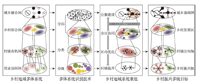
图1
县域乡村振兴规划技术思路
Fig. 1
The technical thinking of rural revitalization planning
2.3 乡村振兴规划研制方法
县域乡村振兴规划,是以乡村地域系统为对象,利用综合的技术手段和方法,分析县域发展地理环境与区位条件,甄别乡村地域结构与类型,探明乡村空间形态与格局,提出乡村振兴多级目标的实现过程和实施路径。其核心是围绕乡村地域系统结构调整与格局优化主题,应用系统诊断的科学方法和“三主三分”规划技术,系统识别主体功能、划定主导类型,进而制定规划“三定”(定性、定量、定位)方案,充分考虑规划建设的优势区、优先序,完成主要用途分级与发展定序,在此基础上综合研制乡村振兴总体规划(图2)。
图2
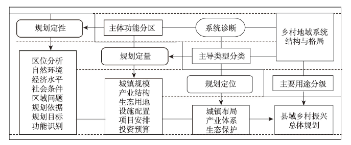
图2
乡村振兴规划研制方法与技术要点
Fig. 2
Research methods and technical points of rural revitalization planning
(1)主体功能分区
主体功能区划是具有应用性、创新性、前瞻性的一种综合地理区划[34]。基于全国及省级主体功能规划,遵循县域空间分异规律和多功能原理,建立指标体系和分区原则,诊断并划定主体功能区。通常依据县域土地与产业类型指标、经济发展绝对指标、城乡关系相对指标,以及地貌分异特征,将县域城乡系统划分为不同的地域功能区。如果县域内地貌分异格局明显,则主要依据地貌单元对县域进行功能区划分。
(2)主导类型分类
土地是人类赖以生存和发展的基础资源,土地利用是区域一切经济社会活动的重要载体,也是气候变化等自然过程、政策调控等人文过程及其交互作用效应的一面镜子。土地利用类型则客观反映了一定范围内地域功能分异的主导特征。因此,在主体功能分区基础上,进一步根据土地利用类型,参考县域土地利用总体规划、县域空间规划方案,划分出村镇建设、农业发展、工业用地、生态保护等不同类型,为县域城镇化、产业体系、农业生产、生态建设布局等提供空间支撑。
(3)主要用途分级
土地利用类型既代表着土地的主要用途,也呈现出同一用途的程度差异。譬如村镇类型归属于城镇村建设用地,按照等级规模和经济社会发展水平,将村镇类型细分为县城—重点(中心)镇—一般乡镇—中心村(社区)—自然村等不同级别。同样地,综合分析耕地质量、作物类型和生产方式,将农业类型划分为高值农业区、一般农业区和低值农业区,也可根据农业地域特征与综合产能分为重点农业区、一般农业区;综合分析工业产品类型和产出效率,将工业类型划分为高值工业区、一般工业区和低值工业区,也可根据工业区建设等级分为国家级、省级、市县级和乡镇级工业区;综合分析生态保护区等级和生态系统价值,将生态类型划分为生态高值区、一般生态区和脆弱生态区,也可根据保护区等级划分为国家级、省级保护区,县级重点生态区和一般生态区。
(4)规划研制要点
首先要深入研究新时代乡村振兴的科学内涵与战略要义,紧密结合区域特点和发展特色,系统解析特定县域资源、环境、生态等自然条件和经济、社会、文化等人文特征。在此基础上重点研判乡村振兴规划内容及其技术规范。其研制要点:① 研究县级乡村振兴规划的时代背景与总体定位,明确阶段性发展模式、特色领域与重点方向;② 研制县域主体功能分区、主导类型分类、主要用途分级体系,探析国土空间地域格局与分异规律,保障乡村振兴规划与国土空间规划、国民经济与社会发展规划有机衔接;③ 探究不同主体功能区协同方案,以及特定功能区内不同主导类型的空间构型、结构关系,主要包括城镇村聚落类、生态保护类、产业发展类、社会文化类等,重视突出乡土文明、乡村文化及社会要素的价值,加强乡村特色文化的保护与传承,加强乡村社会合作网络与治理体系的培育;④ 探明各个主导类型在其规模、水平上的地方关联与等级体系,主要包括村镇体系、产业体系、生态保护体系、基础设施与公共服务体系等。最终形成以主体功能、主导类型为基础,以村镇体系为骨架,以产业体系为支撑,以生态保护、基础设施与公共服务为保障的乡村振兴总体规划方案。
3 典型县域实证应用
县级乡村振兴规划要以特定县域为对象,以村域为单元,以县域的腹地区域为背景来综合谋划和研制乡村振兴总体方案。核心工作是依据乡村地域多体系统理论,利用分区—分类—分级技术方法,系统甄别乡村振兴“网—区—场—极”的层级空间,优化重组乡村地域系统空间体系。本文对乡村振兴相关理论与“三主三分”技术方法进行了系统总结,并应用于中国西部农牧交错区典型县域——宁夏盐池县乡村振兴总体规划实践。针对盐池县的地域特色与发展特点,研究创建了乡村振兴规划空间组织体系(图3)。
图3
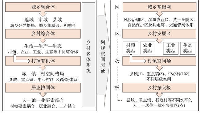
图3
盐池县乡村振兴规划空间组织体系
Fig. 3
Spatial organization system of Rural Revitalization Planning in Yanchi County
盐池县位于宁夏回族自治区东部,陕、甘、宁、蒙四省区接壤的中心地带,国土面积8522.2 km2,下辖4镇、4乡和102个行政村。2018年总人口17.3万人,国内生产总值85.5亿元。县境内地势南高北低,南部为黄土丘陵区,海拔1600~1800 m,沟壑纵横;中部为引黄灌溉农业区,人口与产业相对集中,基础设施较为完善;北部为鄂尔多斯缓坡丘陵区,海拔1400~1600 m,地势开阔平缓,风沙草滩为主,生态环境脆弱,属于典型的大陆性季风气候区,干旱少雨,年均降水量300 mm,年均气温7.8 ℃,冬夏两季平均温差28 ℃左右。盐池县自然资源丰富、文化底蕴深厚、地域特色鲜明,誉为“中国滩羊之乡”“中国黄花之乡”,还是中国革命老区和红色根据地、全国治沙绿化先进县、西北重要的石油及煤炭基地,笔者称之为“五彩盐洲”。农业乡村发展面临的主要问题在于区域性干旱缺水、生态脆弱、地广人稀,是国家级贫困县[35]。2017年脱贫退出,成为宁夏回族自治区首个摘帽贫困县。2018年盐池成为自治区首个“脱贫富民与乡村振兴”先行示范县,率先编制完成《盐池县乡村振兴总体规划(2018—2022)》,并用于先行示范县建设实践。
3.1 县域主体功能识别
根据地貌格局和土地利用特征,盐池县域主体功能划分为草原风沙区、灌溉农业区、丘陵沟壑区和哈巴湖自然保护区①(中国科学院地理科学与资源研究所. 《盐池县乡村振兴总体规划(2018—2022)》, 2019)。① 草原风沙区位于盐池县西北部,风沙地貌特征明显,耕地多为旱地。生态治理与保护为先,限制过牧和过度开发;② 灌溉农业区位于盐池县中部,扬黄灌溉的耕地呈散点状分布在草原风沙地貌背景之中,节水为要、水土耦合,灌溉农业特征明显;③ 丘陵沟壑区位于县域南部地区,以黄土丘陵沟壑地貌为主,以水土保持为前提,发展小杂粮、经果林种植和生态文化旅游具有良好的基础和优势;④ 哈巴湖自然保护区以哈巴湖国家级自然保护区范围为界,重点保护荒漠—湿地典型自然生态系统,遵循国家自然保护区条例,发挥生态涵养和科研功能,实现区域科学管理、保护和合理利用(图4a)。
图4
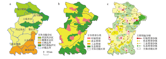
图4
盐池县乡村振兴规划分区、分类与分级
Fig. 4
Division, classification and gradation of Rural Revitalization Planning in Yanchi County
3.2 主导土地类型划分
在主体功能分区基础上,与县域空间规划相衔接,依据县域土地利用总体规划图,按照保护生态环境、保护基本农田、留足发展空间的规划原则,将盐池县主导土地类型划分为村镇类型、农业类型、工业类型和生态类型(图4b)。① 村镇类型主要承担生活功能和工商业生产功能,其空间分布也呈现“大分散、小集聚”特征,村镇聚落以县城、3个镇驻地,以及青山乡较为集中,其他各乡镇均呈现小规模分散分布;② 农业类型的空间分布相对集中,北部县城—王乐井一带、南部丘陵沟壑区及边缘地带分布面积大、地域特色明显,中部灌溉农业区耕地呈现斑块状、组合式分布;③ 工业类型主要包括大水坑、惠安堡等工业区、单体工业用地,以能源矿产开采、精深加工和农产品加工业为主,规划引导工业向低耗水方向升级和园区集聚;④ 生态类型的面积最大,广泛分布在县域全境,区域差异较明显。南部黄土丘陵区分布细碎,中部和北部地区相对完整、连片集中。
3.3 主要用途等级评定
以构建县域乡村振兴空间体系为目标,依据地域功能效用与强度,对村镇类型、农业类型、工业类型、生态类型分别进行等级评定(图4c)。① 选取人口、经济、基础设施等指标(表1),定量分析城、镇、村社会经济发展水平及其差异,探明县城、重点镇、中心村的空间组合结构。共识别出县城1个、重点镇3个、中心村23个,以此为组织架构,建立“县城—重点镇—一般乡镇—中心村—自然村”城镇村空间体系。盐池县的县城及重点镇在空间上呈现均衡分布,由于南部丘陵沟壑区地形复杂,南部地区的两个重点镇的位置偏中部;② 根据农业地域特征与综合产能,将农业类型划分为重点农业区、一般农业区。重点农业区的基本农田面积占60%以上,主要分布在灌溉农业区和丘陵沟壑区;③ 依据主要工业类型和规模,将工业类型划分为高值工业区、一般工业区、工业企业(点);④ 按照生态保护区等级与规模,将生态类型划分为国家保护区、县级生态区和一般生态区。一般生态区面积大、分布广,国家保护区和县级生态区主要分布在灌溉农业区和草原风沙区,相对集中分布。
表1 城镇村等级识别指标体系
Tab. 1
| 效用等级类型 | 准则层 | 指标层 | 计算方法及指标说明 |
|---|---|---|---|
| 城镇 | 人口 | 人口数量 人口增长速度 受教育程度 镇驻地人口密度 | 镇域常住人口数量(+) 近5年镇域人口的平均增长率(+) 镇域高中及以上文化程度人口比例(+) 镇驻地所在村域人口数量/村域面积(+) |
| 经济 | 生产总值 注册企业数量 规模企业数量 | (+) (+) (+) | |
| 基础设施 | 道路密度 公服配套完善度 | 道路等级加权长度*/镇域面积(+) 医院、幼儿园、小学、中学、卫生室、文化站、集贸市场等种类数量(+) | |
| 村庄 | 人口 | 人口密度 老龄化程度 人口增长速度 外出人口占比 受教育程度 | 村域常住人口数量/村域面积(+) 村域60岁以上老年人比例(-) 近5年村域人口的平均增长率(+) 外出半年以上人口比例(-) 村域高中及以上文化程度人口比例(+) |
| 经济 | 农民人均纯收入 耕地占比 | (+) 耕地面积/村域面积(+) | |
| 基础设施 | 道路密度 公服配套完善度 | 道路等级加权长度*/村域面积(+) 医院、幼儿园、小学、中学、卫生室、文化站、集贸市场数量(+) | |
| 资源 | 人均耕地面积 人均水资源量 森林覆盖率 旅游景点数量 | 耕地面积/户籍人口数量(+) 可利用水资源量/人口数量(+) (+) (+) |
注:*选取乡村地区可以自由进出的国道、省道和县道非封闭等级道路,按照道路等级速度标准和是否有高速出入口进行加权计算道路长度,国道权重为2,省道权重为1.2,县道权重为1,有高速出入口时对按照道路等级速度标准加权的道路长度乘以1.2处理。
3.4 乡村振兴规划及发展策略
通过利用“三主三分”技术方法,系统揭示盐池县乡村地域类型、功能空间结构及其分异特征。结合盐池县自然地理背景和社会经济发展特点,确立乡村振兴规划的主导原则是坚持生态优先、因地制宜、产业支撑、城乡融合。在空间与时序上做好与《盐池县空间规划(2016—2035)》的有机衔接,以构建县域生态、生产、生活空间体系为重点,按照乡村振兴“产业兴旺、生态宜居、乡村文明、治理有效、生活富裕”的目标要求,推进形成要素集聚、结构合理、空间有序的城镇村发展建设新格局(图5)。
图5
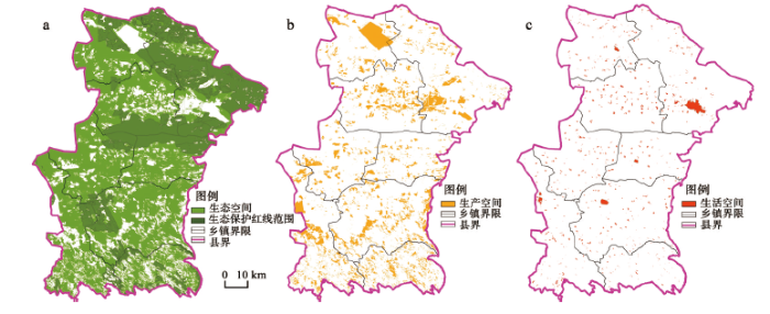
图5
盐池县乡村振兴“三生空间”优化格局
Fig. 5
The spatial pattern of ecology, production and life in rural revitalization of Yanchi County
乡村振兴规划是实施乡村振兴战略的空间蓝图和行动指南。在资源环境承载力基础上,需要依据乡村地域多体系统格局与分异规律,进一步深化细化乡村振兴统筹谋划、整域协调、优化布局、科学管控的基本策略。针对该县生态脆弱、地广人稀的地域特征,乡村振兴规划强化了生态空间有效保护、生产空间地域均衡、生活空间适度集聚中的空间治理理念(图5)。重点整合县城及重点乡镇资源、明晰特色方向、完善基础设施建设、有效提升城镇职能和地域效能,着眼推进乡村治理体系和治理能力现代化长远目标,针对现实问题和立足区域优势,着力建设支撑乡村振兴规划的城乡交通体系、乡村产业体系、城镇空间体系和村镇服务体系(图6)。城乡空间治理方面,要围绕生态保育、资源开发、能源利用、乡村减贫的发展目标,构建以盐池为中心的陕甘宁蒙四省接壤区城乡交通管网体系,整体推进“三联”(交通道路联网、引水管线联通、信息平台联建)同区化和一体化;乡村产业发展方面,要加快壮大乡村专业合作组织、村镇混合制经济,重点建设以滩羊、黄花、小杂粮产业化为特色和生态、文化旅游智慧化为亮点的现代产业体系;城镇空间与村镇服务体系方面,要突出中心城镇地位和综合功能,构建“大分散、小集聚”聚落格局,形成以县城、重点乡镇为中心,以教育、医疗、文化、信息等公共资源均衡配置为基础,以若干中心村镇及社区“三产”融合和人地协调发展为导向的村镇有机体、居业协同体。在乡村治理与创新机制上,建立健全责任机制、奖惩制度,突出统筹兼顾、因地制宜、精准施策,治沙、节水、减贫、兴业与富民多措并举、讲求实效,全力保障乡村振兴战略落实、规划落地。
图6
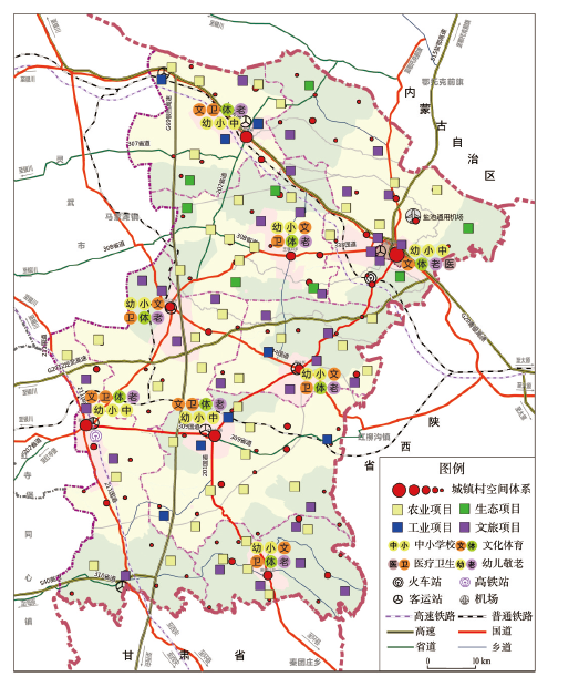
图6
盐池县乡村振兴规划布局
Fig. 6
The general planning layout of rural revitalization in Yanchi County
4 结论与讨论
中国乡村发展已进入全面转型新阶段,农业农村现代化是实施乡村振兴战略的总目标,重视强化新时期农业农村发展规律探究、深化乡村振兴规划技术方法研究,是加快推进新时代乡村振兴战略、服务农业农村现代化的重要举措。本文探讨了新时期乡村振兴规划的基础理论,尝试创建了乡村振兴规划“主体功能分区、主导类型分类、主要用途分级”的“三主三分”技术方法。在理论上,探明了乡村地域多体系统及其城乡融合体、乡村综合体、村镇有机体、居业协同体的分层识别机理,揭示了乡村振兴“三生”(生态、生态、生活)地域功能及其空间特征。在实践上,深入探析了“三主三分”技术方法与区域国土空间规划、城乡发展总体规划等规划的有效衔接途径,诠释了乡村地域多体系统层级结构与乡村振兴规划“网—区—场—极”空间格局的对应关系和优化路径,直接支撑了宁夏盐池县乡村振兴总体规划及其宁夏回族自治区“脱贫富民与乡村振兴”盐池先行示范区建设,以期为创新中国乡村振兴规划方法体系、制定县级乡村振兴规划与科学决策提供参考依据。
宁夏盐池县乡村振兴典型案例研究表明,乡村振兴规划主要内容与技术要点体现在4个方面:① 研究县级乡村振兴规划的时代背景与总体定位,明确阶段性发展模式、特色领域与重点方向;② 研制县域主体功能分区、主导类型分类、主要用途分级体系,探析国土空间地域格局与分异规律;③ 探究不同主体功能区协同方案,以及特定功能区内不同主导类型的空间构型、结构关系;④ 探明各个主导类型在其规模、水平上的地方关联与等级体系。盐池县乡村振兴规划“三主三分”方案:主体功能分为草原风沙区、灌溉农业区、丘陵沟壑区、哈巴湖自然保护区;主导类型包括村镇类型、农业类型、工业类型、生态类型;主要用途(以村镇聚落为例)按照“县城—重点镇—中心村”等级体系,识别出县城1个,大水坑镇、惠安堡镇、高沙窝镇等重点镇3个,长城、田记掌、回六庄等中心村23个。乡村振兴规划是实施乡村振兴战略的空间蓝图和行动指南,需要遵循乡村地域多体系统格局与分异规律,着力建设支撑乡村振兴规划的城乡交通体系、乡村产业体系、城镇空间体系和村镇服务体系。编制和实施乡村振兴总体规划的主要任务,是按照“产业兴旺、生态宜居、乡村文明、治理有效、生活富裕”的目标要求,推进形成要素集聚、结构合理、空间有序的城镇村发展建设新格局。盐池县乡村振兴总体规划编制,力求做到县域多元数据融合、多技术方法整合和公众参与、专家征询结合,但是在县域乡村转型过程、空间格局情景,以及乡村振兴区域联动、智慧乡村、市场配置等研究方面有待深入开展。
中国地域范围广,乡村发展差异大、转型面临问题多,区域差距、城乡差异、村镇差别决定了乡村治理、乡村振兴规划与城乡融合发展战略的复杂性、多元性和差异性[36,37,38]。1978年中国通过农村改革拉开了改革开放大幕,历经40多年成功解决了温饱问题,践行了精准扶贫“五大”(重大理论创新、宏大制度设计、伟大扶贫实践、浩大帮扶队伍、巨大减贫成效)范式,2020年如期实现全面脱贫攻坚和消除绝对贫困。当今中国已进入全面建成小康社会和“城乡中国”新时代,乡村发展“六地”(中华民族农耕文明的传承地、农业生产农民居住的集中地、工业化与城镇消费的原料地,以及保障生态粮食安全战略高地、现代城市健康发展重要腹地、创新创业康养文化兴盛之地)功能日益凸显,亟需通过科学实施乡村振兴战略,开启中国城乡融合和现代化建设新局面。规划若不能落地,目标就可能落空。新时代乡村振兴是一个关系破解中国“三农”问题、实现国家现代化的重大领域[36]。乡村转型—城乡融合—乡村振兴—高质量发展成为未来发展的大逻辑、新常态。地理学特别是人文与经济地理学的创新贡献大有可为,面向战略需求要致力于研发乡村地域系统探测器、研究乡村转型发展动力源、研制全面乡村振兴路线图。在理论方面,创建乡村地域系统”三度“(大跨度、多尺度、分维度)机理解析与诊断模型,揭示新型城镇化与乡村振兴“双轮驱动”下乡村要素整合、人地耦合、城乡融合发展动力机制,探明乡村人地系统演化机理、动态过程与科学途径,为乡村振兴的长远谋划、短期规划提供理论依据;在方法方面,应用大数据、人工智能等技术,开发乡村地域系统的弹性、质态、功效等参数化估量方法,建立乡村健康体检与乡村振兴量表体系。围绕绿色发展与美丽乡村建设,构建“绿发指数”,聚焦“四绿”:绿人(绿色生产者、从业者)、绿地(绿色健康土地与环境)、绿业(绿色有机、生态产业)、绿权(绿色发展权益保障机制与制度),制定乡村振兴成效第三方评估考核办法;在实践方面,遵循人地关系地域系统的分异格局与规律,将乡村人地系统划分为农业系统、村庄系统、乡域系统、城镇系统等不同地域类型,分区分类开展乡村振兴地域模式的系统梳理和典型示范。有针对性地开展乡村振兴规划“回头看”,抓住“十四五”规划编制的有利时机,对照目标、核准问题、精准施策。加快建设乡村振兴规划与管理的信息化、智能化和工程化平台;深入推进面向2030年全球可持续发展目标与世界乡村振兴[8]科技需求的大数据模拟、国际化合作和网络化共享。乡村振兴规划的质量和效果主要取决于3个方面:一是规划前期研究的扎实程度,通过严格论证评审;二是规划过程监控的精准程度,开展项目可行性评价;三是规划后期的落地程度,实行综合成效评估。简言之,把脉准、可操作、有实效。当前乡村振兴规划研究应着眼于区域协调、城乡融合、农业安全与民生保障的大局,着力破解乡村可持续发展面临的“乡村病”现实难题和“城进村衰”突出问题。广大地理学、管理学、社会学等相关领域的科研工作者,理应把创新发展乡村振兴规划理论与方法论,科学推进乡村振兴战略落实、规划落地,作为科学研究服务支撑乡村振兴国家战略的立命准则、时代重任。
致谢:
李裕瑞、刘烜赫、曹智等在规划研制和制图工作中给与了大力协助,宁夏回族自治区农业农村厅、盐池县在规划技术示范中给与了大力支持,借此一并致谢!
参考文献
Rural regional system and rural revitalization strategy in China
中国乡村地域系统与乡村振兴战略
Development and management tasks of the Yellow River Basin: A preliminary understanding and suggestion
黄河流域的综合治理与可持续发展
Realizing China's urban dream
DOI:10.1038/509158a URL [本文引用: 1]
Regional differentiation characteristics of rural poverty and targeted poverty alleviation strategy in China
中国农村贫困化地域分异特征及其精准扶贫策略
Theoretical analysis and technical methods of "multiple planning integration" in the rural to urban transition period in China
DOI:10.18306/dlkxjz.2016.05.001
URL
[本文引用: 2]

In recent years, China’s industrialization and urbanization have entered a new transformational stage of development. The contradictions between innovation-driven development and institutional constraints are intensified, and the problems of resource shortage and inefficiency of resource allocation are becoming increasingly prominent. Therefore, multiple planning integration that merges economic and social development planning, urban spatial planning, and land use planning into an overall planning system has received wide attention from academics and governments at all levels. Promoting multiple planning integration and innovating the theories and technical methods of regional planning, as well as constructing the spatial planning system of national territory with Chinese characteristics, have become an important issue in further reform. This study analyzed the practical problems of planning segregation and essential characteristics of multiple planning contradictions and discussed the strategic positioning of multiple planning integration. Then we constructed a basic theoretical framework of multiple planning integration with “three primaries” and “three separations”. Finally, the technical approaches and long-term mechanisms for gradual multi-plan adjustments were proposed. It can be concluded that the essence of multiple planning integration is to integrate and coordinate all plans at the strategic level of regional spatial structure optimization, and guide the optimization of urban-rural land allocation so that it can achieve spatial consistency, functional integration, and coordination in the development process. Multiple planning integration is neither to prepare a plan nor to focus on solving the greatest common divisor of existing multiple plans, but to promote the formation of a regional planning system with the characteristics of overall-and sub-planning, clear hierarchy, and functional specificity.
转型发展期“多规合一”理论认知与技术方法
DOI:10.18306/dlkxjz.2016.05.001
URL
[本文引用: 2]
In recent years, China’s industrialization and urbanization have entered a new transformational stage of development. The contradictions between innovation-driven development and institutional constraints are intensified, and the problems of resource shortage and inefficiency of resource allocation are becoming increasingly prominent. Therefore, multiple planning integration that merges economic and social development planning, urban spatial planning, and land use planning into an overall planning system has received wide attention from academics and governments at all levels. Promoting multiple planning integration and innovating the theories and technical methods of regional planning, as well as constructing the spatial planning system of national territory with Chinese characteristics, have become an important issue in further reform. This study analyzed the practical problems of planning segregation and essential characteristics of multiple planning contradictions and discussed the strategic positioning of multiple planning integration. Then we constructed a basic theoretical framework of multiple planning integration with “three primaries” and “three separations”. Finally, the technical approaches and long-term mechanisms for gradual multi-plan adjustments were proposed. It can be concluded that the essence of multiple planning integration is to integrate and coordinate all plans at the strategic level of regional spatial structure optimization, and guide the optimization of urban-rural land allocation so that it can achieve spatial consistency, functional integration, and coordination in the development process. Multiple planning integration is neither to prepare a plan nor to focus on solving the greatest common divisor of existing multiple plans, but to promote the formation of a regional planning system with the characteristics of overall-and sub-planning, clear hierarchy, and functional specificity.
Notes for a substantive theory of rural planning: Evidence from the US experience
Revitalize the world's countryside
DOI:10.1038/548275a URL [本文引用: 2]
Research on the urban-rural integration and rural revitalization in the new era in China
DOI:10.11821/dlxb201804004
URL
[本文引用: 4]
Cities and villages are components of a specific organism. Only the sustainable development of two parts can support the prosperous development as a whole. According to the theory of man-earth areal system, urban-rural integrated system and rural regional system are the theoretical bases for entirely recognizing and understanding urban-rural relationship. To handle the increasingly severe problems of "rural disease" in rapid urbanization, accelerating rural revitalization in an all-round way is not only a major strategic plan for promoting the urban-rural integration and rural sustainable development, but also a necessary requirement for solving the issues related to agriculture, rural areas, and rural people in the new era and securing a decisive victory in building a moderately prosperous society in all respects. This study explores the basic theories of urban-rural integration and rural revitalization and analyzes the main problems and causes of rural development in the new era, proposing problem-oriented scientific approaches and frontier research fields of urban-rural integration and rural revitalization in China. Results show that the objects of urban-rural integration and rural revitalization is a regional multi-body system, which mainly includes urban-rural integration, rural complex, village-town organism, and housing-industry symbiosis. Rural revitalization focuses on promoting the reconstruction of urban-rural integration system and constructs a multi-level goal system including urban-rural infrastructure networks, zones of rural development, fields of village-town space and poles of rural revitalization. Currently, the rural development is facing the five problems: high-speed non-agricultural transformation of agriculture production factors, over-fast aging and weakening of rural subjects, increasingly hollowing and abandoning of rural construction land, severe fouling of rural soil and water environment and deep pauperization of rural poverty-stricken areas. The countryside is an important basis for the socioeconomic development in China, and the strategies of urban-rural integration and rural revitalization are complementary. The rural revitalization focuses on establishing the institutional mechanism for integrated urban-rural development and constructs the comprehensive development system of rural regional system, which includes transformation, reconstruction and innovation in accordance with the requirements of thriving businesses, pleasant living environments, social etiquette and civility, effective governance, and prosperity. Geographical research on rural revitalization should focus on the complexity and dynamics of rural regional system and explore new schemes, models and scientific approaches for the construction of villages and towns, which are guided by radical cure of "rural disease", implement the strategy of rural revitalization polarization, construct the evaluation index system and planning system of rural revitalization, thus providing advanced theoretical references for realizing the revitalization of China's rural areas in the new era.
中国新时代城乡融合与乡村振兴
DOI:10.11821/dlxb201804004
URL
[本文引用: 4]
Cities and villages are components of a specific organism. Only the sustainable development of two parts can support the prosperous development as a whole. According to the theory of man-earth areal system, urban-rural integrated system and rural regional system are the theoretical bases for entirely recognizing and understanding urban-rural relationship. To handle the increasingly severe problems of "rural disease" in rapid urbanization, accelerating rural revitalization in an all-round way is not only a major strategic plan for promoting the urban-rural integration and rural sustainable development, but also a necessary requirement for solving the issues related to agriculture, rural areas, and rural people in the new era and securing a decisive victory in building a moderately prosperous society in all respects. This study explores the basic theories of urban-rural integration and rural revitalization and analyzes the main problems and causes of rural development in the new era, proposing problem-oriented scientific approaches and frontier research fields of urban-rural integration and rural revitalization in China. Results show that the objects of urban-rural integration and rural revitalization is a regional multi-body system, which mainly includes urban-rural integration, rural complex, village-town organism, and housing-industry symbiosis. Rural revitalization focuses on promoting the reconstruction of urban-rural integration system and constructs a multi-level goal system including urban-rural infrastructure networks, zones of rural development, fields of village-town space and poles of rural revitalization. Currently, the rural development is facing the five problems: high-speed non-agricultural transformation of agriculture production factors, over-fast aging and weakening of rural subjects, increasingly hollowing and abandoning of rural construction land, severe fouling of rural soil and water environment and deep pauperization of rural poverty-stricken areas. The countryside is an important basis for the socioeconomic development in China, and the strategies of urban-rural integration and rural revitalization are complementary. The rural revitalization focuses on establishing the institutional mechanism for integrated urban-rural development and constructs the comprehensive development system of rural regional system, which includes transformation, reconstruction and innovation in accordance with the requirements of thriving businesses, pleasant living environments, social etiquette and civility, effective governance, and prosperity. Geographical research on rural revitalization should focus on the complexity and dynamics of rural regional system and explore new schemes, models and scientific approaches for the construction of villages and towns, which are guided by radical cure of "rural disease", implement the strategy of rural revitalization polarization, construct the evaluation index system and planning system of rural revitalization, thus providing advanced theoretical references for realizing the revitalization of China's rural areas in the new era.
Characteristics and policies of rural evolution in Britain and America and its implication to rural revitalization in China
英美乡村演变特征、政策及对我国乡村振兴的启示
Enlightenment of German Village Competition Program to the rural revitalization of China
德国乡村竞赛计划对我国乡村振兴的启示
Post-rural urbanization and rural revitalization: Can China learn from new planning approaches in contemporary Germany
“后乡村城镇化”与乡村振兴: 当代德国乡村规划探索及对中国的启示
Implementation dynamics for sustainability planning in rural Canada
Strategic planning to sustainable rural development
Rural regional planning experiences in British and America and its implication to rural revitalization of China
英美农村区域规划经验及对中国乡村振兴的启示
A preliminary study rural revitalization planning and its key technologies
乡村振兴规划体系与关键技术初探
Several issues needed to pay attention when compiling rural revitalization plan
编制乡村振兴规划须注意的几个问题
The innovation of county rural area construction plan based on the rural revitalization strategy: A case study of Guangde County in Anhui Province
实施乡村振兴战略, 创新县域乡村建设规划编制: 以《安徽省广德县县域乡村建设规划》为例
Theoretical basis and practice of county rural revitalization planning
县域乡村振兴规划编制的理论基础与实践
Study on the compilation of county rural revitalization planning: Taking Yangling District as an example
县域乡村振兴规划编制研究: 以杨陵区为例
Exploring rural revitalization planning in the new era: Case study of a village in reservoir area in Yingshan County, Hubei Province
新时代乡村振兴规划的探索: 以湖北省英山县某库区村为例
The symbiosis strategy in rural revitalization and Guangxi practice
乡村振兴规划共生策略构建及广西实践
Thoughts on rural planning system under the background of rural revitalization
关于乡村振兴背景下乡村规划体系的思考
Planning low carbon urban-rural ecosystems: An integrated transport land-use model
Research on the pattern of "Four in One" planning method based on rural revitalization
基于乡村振兴背景下的“四位一体”规划方法研究与实践
Practice of village planning based on "multiple planning integration" from the perspective of rural revitalization
乡村振兴视角下基于“多规合一”的村庄规划编制实践
How to play the main role to farmers in rural revitalization
如何发挥农民在乡村振兴中的主体作用
Features and framework of rural revitalization planning system
DOI:10.18306/dlkxjz.2019.09.009
URL
[本文引用: 1]
Implementing the strategy of rural revitalization is an inevitable requirement for solving the main social conflicts in China in the new era, which is related to the success of the country's modernization. Rural revitalization is a comprehensive process of natural and human systems. To implement the strategy of rural revitalization, it is necessary to establish a scientific and sound planning system of rural revitalization in order to coordinate and optimize the allocation of urban and rural factor resources. Based on the system perspective of geography, this study analyzed the connotation of the "rural" concept and the basic characteristics of rural development. It summarized the basic features and main problems and then preliminarily constructed a framework of rural revitalization planning system. The results show that there are multiple attributes of rural system, which contains social and cultural, political and economic, and geographical space. It also has many functions such as production, living, ecological, and cultural. Rural revitalization is a comprehensive process combining rural resources utilization, economic and social development, and coupling of natural and human systems. Rural system is characterized by decentralization of factors and self-organization of development, spatial heterogeneity and diversity of types, dependence on regions and cities, and strong restriction of industrial development by natural factors. Rural revitalization planning is an integrated and coordinated process of allocation of rural spatial factor resources. Its essence is to promote equity-oriented planning and more emphasis should be placed on the participation process of planning. There are some main problems of rural planning. At present, China's rural planning has not yet formed a complete system. Rural planning lacks legal support and the development of rural planning technology and theory lags behind. The boundary and depth of rural revitalization planning have not been clearly understood. The guarantee mechanism for the implementation of plans needs improvement. Based on the above analysis, a "five-in-one" rural revitalization planning system is proposed, including the main planning system, institutional guarantee system, technical support system, multi-planning coordination system, and participation feedback system. This system can coordinate the allocation of rural factor resources more effectively, integrate into regional and urban development, form planning synergy, and activate development vitality. It will also be helpful for enhancing the authority, feasibility, and practicability of rural revitalization planning.
乡村振兴规划的性质及其体系构建探讨
DOI:10.18306/dlkxjz.2019.09.009
URL
[本文引用: 1]
Implementing the strategy of rural revitalization is an inevitable requirement for solving the main social conflicts in China in the new era, which is related to the success of the country's modernization. Rural revitalization is a comprehensive process of natural and human systems. To implement the strategy of rural revitalization, it is necessary to establish a scientific and sound planning system of rural revitalization in order to coordinate and optimize the allocation of urban and rural factor resources. Based on the system perspective of geography, this study analyzed the connotation of the "rural" concept and the basic characteristics of rural development. It summarized the basic features and main problems and then preliminarily constructed a framework of rural revitalization planning system. The results show that there are multiple attributes of rural system, which contains social and cultural, political and economic, and geographical space. It also has many functions such as production, living, ecological, and cultural. Rural revitalization is a comprehensive process combining rural resources utilization, economic and social development, and coupling of natural and human systems. Rural system is characterized by decentralization of factors and self-organization of development, spatial heterogeneity and diversity of types, dependence on regions and cities, and strong restriction of industrial development by natural factors. Rural revitalization planning is an integrated and coordinated process of allocation of rural spatial factor resources. Its essence is to promote equity-oriented planning and more emphasis should be placed on the participation process of planning. There are some main problems of rural planning. At present, China's rural planning has not yet formed a complete system. Rural planning lacks legal support and the development of rural planning technology and theory lags behind. The boundary and depth of rural revitalization planning have not been clearly understood. The guarantee mechanism for the implementation of plans needs improvement. Based on the above analysis, a "five-in-one" rural revitalization planning system is proposed, including the main planning system, institutional guarantee system, technical support system, multi-planning coordination system, and participation feedback system. This system can coordinate the allocation of rural factor resources more effectively, integrate into regional and urban development, form planning synergy, and activate development vitality. It will also be helpful for enhancing the authority, feasibility, and practicability of rural revitalization planning.
Unravelling the complexity in achieving the 17 sustainable-development goals
DOI:10.1093/nsr/nwz038 URL [本文引用: 1]
YangYuanyuan. Strategic adjustment of land use policy under the economic transformation
DOI:10.1016/j.landusepol.2017.07.005 URL [本文引用: 1]
Measuring the symbiotic development of rural housing and industry: A case study of Fuping County in the Taihang Mountains in China
DOI:10.1016/j.landusepol.2018.12.013 URL [本文引用: 1]
Building new countryside in China: A geographical perspective
DOI:10.1016/j.landusepol.2009.06.006 URL [本文引用: 1]
Accelerated restructuring in rural China fueled by 'increasing vs. decreasing balance' land-use policy for dealing with hollowed villages
DOI:10.1016/j.landusepol.2011.04.003
URL
[本文引用: 1]
Rapid industrialization and urbanization in China has produced a unique phenomenon of 'village-hollowing', shaped by the dual-track structure of socio-economic development. This paper analyzes the phenomenon of 'village-hollowing', identifying the processes and influences that have driven their evolution, and highlighting the challenge that the locking-up of unused rural housing land in 'hollowed villages' presents for China in the context of concerns over urban development and food security. The paper examines the 'increasing vs. decreasing balance' land-use policy has been adopted by the Chinese government in response to the problem, which seeks to balance increases in urban construction land with a reduction in rural construction land. The implementation of the scheme is discussed through a case study of Huantai county in Shandong province, drawing attention to its contested and contingent nature. It is argued that the policy is a top-down approach to rural restructuring that necessarily requires the acquiescence of local actors. However, it is noted that failures to adequate engage with local actors has led to resistance to the policy, including violent protests against the demolition of housing. The paper suggests that lessons might be learned from Europe by incorporating elements of 'bottom-up' planning into the process. As such, the paper demonstrates that rural restructuring in China is a dynamic, multi-scalar and hybrid process that shares common elements and experiences with rural restructuring in Europe and elsewhere. but which is also strongly shaped by the distinctive political, economic, social and cultural context of China. (C) 2011 Elsevier Ltd.
Draft of major function oriented zoning of China
DOI:10.11821/dlxb201502002
URL
[本文引用: 1]
Major Function Oriented Zoning (MFOZ) is the blueprint for the future developmnt and protection pattern of China's territory, and has been raised to from major function zones planning to major function zoning strategy and major function zoning institution. From 2004 to 2014, the author organized a series of research projects to compose MFOZ for the country, studied basic theory of regional function and MFOZ technical process, and proposed that space controlling zones of national and provincial scales can be divided into four types: urbanized zones, foodstuff-security zones, ecological safety zones, cultural and natural heritage zones. On this basis, major function zones of county scale should be transferred to optimized, prioritized, restricted, and prohibited zones. In this paper, a regional function identification index system comprising nine quantitative indicators (including water resources, land resources, ecological importance, ecological fragility, environment capacity, disaster risk, economic development level, population concentration and transport superiority) and one qualitative indicator of strategic choice is developed. Based on the single index evaluation, comprehensive evaluation using regional function suitability evaluation index is conducted, aiming at testing several key parameters including lower limit of protection zones and upper limit of development zones at the provincial level. In addition, a planning-oriented zoning method of major function zones is also discussed, which has brought the first MFOZ planning in China. According to the MFOZ caliber, it is forecasted that national spatial development intensity will rise from 3.48% in 2010 to 3.91% in 2020. Furthermore, according to caliber of the provincial integrated MFOZ planning, the area of optimized, prioritized and restricted zones accounts for 1.48%, 13.60% and 84.92%, respectively, and that of urbanized, foodstuff-security and ecological safety zones accounts for 15.08%, 26.11% and 58.81%, respectively. In combination of analyses of development level, resources and environmental carrying status and quality of the people's livelihood, the main characteristics of MFOZ were identified. Through verification, MFOZ draft of national and provincial scales, which is interactively accomplished with "MFOZ Technical Process" put forward by the author, is mostly above 80% identical with what have been forecasted.
中国主体功能区划方案
DOI:10.11821/dlxb201502002
URL
[本文引用: 1]
Major Function Oriented Zoning (MFOZ) is the blueprint for the future developmnt and protection pattern of China's territory, and has been raised to from major function zones planning to major function zoning strategy and major function zoning institution. From 2004 to 2014, the author organized a series of research projects to compose MFOZ for the country, studied basic theory of regional function and MFOZ technical process, and proposed that space controlling zones of national and provincial scales can be divided into four types: urbanized zones, foodstuff-security zones, ecological safety zones, cultural and natural heritage zones. On this basis, major function zones of county scale should be transferred to optimized, prioritized, restricted, and prohibited zones. In this paper, a regional function identification index system comprising nine quantitative indicators (including water resources, land resources, ecological importance, ecological fragility, environment capacity, disaster risk, economic development level, population concentration and transport superiority) and one qualitative indicator of strategic choice is developed. Based on the single index evaluation, comprehensive evaluation using regional function suitability evaluation index is conducted, aiming at testing several key parameters including lower limit of protection zones and upper limit of development zones at the provincial level. In addition, a planning-oriented zoning method of major function zones is also discussed, which has brought the first MFOZ planning in China. According to the MFOZ caliber, it is forecasted that national spatial development intensity will rise from 3.48% in 2010 to 3.91% in 2020. Furthermore, according to caliber of the provincial integrated MFOZ planning, the area of optimized, prioritized and restricted zones accounts for 1.48%, 13.60% and 84.92%, respectively, and that of urbanized, foodstuff-security and ecological safety zones accounts for 15.08%, 26.11% and 58.81%, respectively. In combination of analyses of development level, resources and environmental carrying status and quality of the people's livelihood, the main characteristics of MFOZ were identified. Through verification, MFOZ draft of national and provincial scales, which is interactively accomplished with "MFOZ Technical Process" put forward by the author, is mostly above 80% identical with what have been forecasted.
Research on identification method and application of rural regional multi-body system
乡村地域多体系统识别方法及应用研究
Research on the geography of rural revitalization in the new era
新时代乡村振兴地理学研究
Planning and implementing smart shrinkage of rural China: The case of Chengdu's rural settlement consolidation with SGME model
DOI:10.5614/jpwk.2019.30.1 URL [本文引用: 1]
