杜志威 , 李郇
, 李郇
DU Zhiwei, LI Xun
通讯作者:
收稿日期: 2017-01-16
修回日期: 2017-07-8
网络出版日期: 2017-11-10
版权声明: 2017 《地理学报》编辑部 本文是开放获取期刊文献,在以下情况下可以自由使用:学术研究、学术交流、科研教学等,但不允许用于商业目的.
基金资助:
作者简介:
作者简介:杜志威(1987-), 男, 广东广州人, 博士, 研究方向为城市与区域发展和规划。E-mail:chiwai_do@foxmail.com
展开
摘要
珠江三角洲是世界范围内经济和城镇发展“增长奇迹”的典型地区,当中以东莞为代表的“外向型城镇化”模式长期受到国内外学者的关注。然而,2008年的金融危机冲击对东莞经济造成巨大冲击,市域范围同时出现了普遍增长与局部收缩两种截然不同的新空间现象。随着中国经济步入新常态,城镇化快速发展过程中伴随的局部收缩现象逐渐引起学界和社会的广泛讨论。基于此,从城镇发展要素的集聚与流动出发,结合经济、人口和用地三个维度,提出理解城镇增长与收缩的分析框架,并对不同类型特征的城镇进行区分:持续增长、转型增长、潜在收缩与显著收缩。在实证分析部分,文章以东莞为案例,通过考察各镇街单元城镇增长与收缩的时间演变和空间格局,结合典型城镇案例分析,从经济危机冲击、刘易斯转折点、路径依赖存在、制度环境安排四个方面探讨东莞城镇增长与收缩的形成机制,最后对增长与收缩的未来深化研究方向进行讨论。
关键词:
Abstract
The Pearl River Delta (PRD), a typical area of rapid urbanization with Dongguan as its most representative case of the 'exo-urbanization' model, has thus long been attracting scholarly attention. However, after the financial crisis in 2008, a new spatial phenomenon has emerged in Dongguan, with overall growth and partial shrinkage taking place in the same city area. As the Chinese economy steps into a state of New Normal, partial shrinkage during a process of rapid urbanization has kindled heated debate. Starting from the vacancy phenomenon caused by the outflow of development factors, this paper has integrated three analytical dimensions, i.e., economy, population, and land, to put forward a framework for understanding urban growth and shrinkage. Four types of towns have been identified in Dongguan, featuring, respectively, continuous growth, resurgent growth, moderate shrinkage, and continuous shrinkage. Moreover, time trajectory and spatial pattern of growing and shrinking have been investigated to account for the distribution characteristic of urban growth and shrinkage. Then, through probing the shocks of economic crisis, Lewisian turning point, path dependence existence and institutional arrangement, we have analyzed the mechanisms of urban growth and shrinkage amid rapid urbanization in Dongguan. Conclusions and avenues for future research are discussed in the last section.
Keywords:
珠江三角洲作为1978年以来“增长奇迹”的代表,为中国经济现代化和快速城镇化提供了无数的先行经验与教训,珠江三角洲对于中国的重要性更超过其经济表现[1]。当中东莞是珠江三角洲“自下而上”农村城镇化的典型地区,短短30多年间从一个落后的农业县迅速成为全球著名的“世界工厂”,城镇化率年均增速达到惊人的4.73%,所形成的“外向型城镇化”模式长期受到地理研究学者的关注[2-5]。然而,2008年金融危机对东莞的实体经济造成巨大冲击,工业经济甚至出现了-3.56%的负增长,“倒闭潮”、“失业潮”频频见诸报道,引发一系列人口流失、企业外迁、厂房空置的城镇收缩现象[6]。
收缩城市(Shrinking Cities)的概念起源于德国去工业化进程中城市出现的人口减少与经济衰退,所伴随的建筑及房产空置、基础设施荒废等现象是城市收缩的标志性特征[7-10]。国际上对于城市收缩的界定主要存在时间跨度和空间尺度的观点争论:收缩城市国际研究网络(SCIRN)以“经历人口流失超过2年的至少拥有1万居民的人口密集地区”定义为收缩城市[11];收缩城市项目(SCP)将“流失人口占总人口10%或年均流失人口超过1%”作为城市收缩的门槛值[8];Schilling等则认为收缩城市必须经历“在40年间持续超过25%人口的流失”[12]等。当前关于城市收缩的动因已经形成一系列解释:欧美老工业基地主要面临着去工业化带来的经济转型和人口流失[13-15];美国的大城市普遍受到郊区化影响导致中心城区面临衰败[15-16];东欧和前苏联地区城市由于政治局势和制度变革陷入了经济与人口的长期收缩[13-14, 17];老龄化、低生育率等人口结构问题引发日本城市严重的人口负增长[14, 18],而追溯收缩城市的理论来源一般从传统的城市发展阶段理论、城市生命周期理论出发[9-10]。此外,根据收缩空间在城市区域的不同形态,可以区分为以局部建筑空置为特征的“穿孔状”收缩与以内城空心化为特征的“圈饼状”收缩两种主要类型[9, 19]。
作为后增长时代下的新生事物,国内收缩城市(城镇)在相关研究范式、内涵界定、评价指标等研究尚处于起步阶段。随着中国经济步入新常态,快速城镇化过程中伴随的局部收缩现象已逐渐引起学术领域和规划领域的广泛关注[20-22]。当前中国部分资源型矿业城市、大都市外围的边缘城镇所出现的收缩现象,符合国际上对资源枯竭、去工业化、依附作用导致城市收缩的解释。在经济全球化背景下,全球生产活动的跨区域组织与重构,加速资本、劳动力等生产要素在世界范围内流动与集聚,资本过度积累所引发周期性的经济危机对不同空间尺度下城镇增长与收缩的影响尤为显著[9, 23]。
2008年的全球性金融危机对东莞城镇发展冲击是前所未有的,并引发快速城镇化过程中的普遍增长与局部收缩并存的新空间现象。基于此,本文以东莞为案例进行实证,探讨经济危机对快速城镇化地区的城镇发展的影响,通过分析其城镇增长与收缩的时间演变与空间格局,结合典型城镇案例探讨其增长与收缩的形成机制,试图为国际收缩城市研究提供来自发展中国家的研究经验,同时也为中国乃至发展中国家的城镇发展转型提供重要的案例证据。
人口外流所导致的空置现象是收缩在城市空间的标志性特征[8-10],城市收缩的实质是资本、劳动力等可流动生产要素的外流和迁出,从而在城市的物理空间留下厂房建筑空置、基础设施荒废等空间表征。传统城市经济学理论认为城市发展是资本、劳动力等生产要素在城市空间流动与集聚的过程,城市化是城市增长的空间表现[24-25]。由此,理解城市收缩的形成可以从城市发展要素的流动与集聚出发,当经济、人口等发展要素从城市范围流出以后,城市中的社会经济活动强度与密度必然出现下降,当经济活动与人口活动范围与城市建成区范围出现不匹配,固定在城镇建设用地的厂房、住宅、道路将由于使用强度的下降而造成空置的发生。哈维在解释资本的“时空修复”指出,资本必须不断寻找新的空间以实现资本增值,当城市中过剩的资本和劳动力发生空间转移后,被物化国土空间中的资本却遗留下破坏和贬值的痕迹[26-27]。
城市人口规模的缩减是当前国内外研究理解城市收缩的主要观点,但随着依靠技术进步、人力资本和知识的“内生增长模式”[28]受到普遍重视,单纯采用人口维度来评价城市收缩面临一定的局限性,难以解释由于劳动节约型技术进步带来的城镇增长。正在经历人口收缩的城市不一定会走向消亡,也可能通过产业经济结构调整实现城市发展转型或复兴。由此,综合考虑不同生产要素对城市发展的影响,有助于更好地理解城市的增长与收缩,当前部分学者已开始尝试将人口指标与经济指标或者建设用地指标结合,判别不同类型的城市增长与收缩[15, 29-30]。
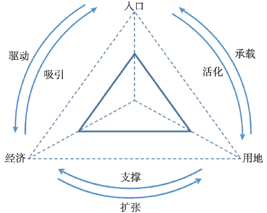
基于此,本文认为理解城镇增长与收缩,需要结合经济维度、人口维度和用地维度三个方面(图1)。其中,经济维度是城镇发展的动因,资本在空间范畴的流动方向影响着增长或收缩的总体趋势,而且经济要素具有较高的活跃性,能够直接反映城镇的发展状况;人口维度是城镇发展的核心,城镇人口数量决定了城镇的规模和等级,也影响着城市社会经济活动范围,同时人口要素与经济要素具有趋同性;而用地维度是城镇发展的载体,承载着城市经济与人口活动,建设用地范围与土地利用强度是城市发展状况的物理性空间表征。
图1 理解增长与收缩的三个维度
Fig. 1 Three dimensions in the understanding of growth and shrinkage
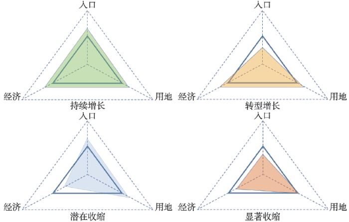
本文利用等边三角形构建增长与收缩的分析框架,以三角形的三条轴线分别表示经济、人口和用地三个维度,根据不同维度之间的增长或收缩变化关系,划分成四种不同城镇类型(图2):持续增长类型(Continuous Growth)、转型增长类型(Resurgence Growth)、潜在收缩类型(Potential Shrinkage)和显著收缩类型(Extreme Shrinkage)。
持续增长类型:代表经济、人口和用地三个维度同时增长,而且各维度相互之间呈现的良性循环。此类型往往是先进制造业或者现代服务业主导的新兴城镇,产业发展前景良好、经济增长动力充足,即使是面对金融危机的外部冲击仍然保持增长,吸引资本要素和劳动力要素不断流入,推动城镇用地规模扩张和土地利用效率提升。
转型增长类型:代表经济维度和用地维度处于增长,但人口维度处于收缩,甚至是人口增速的负增长。此类型一般是成功实现产业结构转型升级的传统制造业城镇,城镇在推进自动化生产或服务业转型的过程中,对原有劳动密集型制造业进行替代,经济结构中依靠劳动力投入的程度减弱,城镇经济增长主要来源于劳动生产率上升,其经济规模和用地规模依然保持增加。
潜在收缩类型:表现为人口维度和用地维度处于增长,但经济维度处于收缩的状况。此类型城镇常见于经济基础较好但转型效果欠佳的城镇,受到经济外部冲击的影响,城镇经济增长原有的动力不断受到削弱,无法引入新的经济增长动力或替代原有发展动力,城镇发展面临经济衰退的风险。由于经济的萧条或衰退将极可能引发产业人口的流失,从而引发前兆性的收缩现象。
显著收缩类型:表现为经济维度和人口维度处于收缩甚至衰退,但用地维度依然保持增加态势。此类型城镇是典型的收缩城市,甚至出现“鬼城”,城镇发展面临经济增长乏力和人口持续流失,亟待通过转型的方式促进城镇的复兴。由于城镇建设用地仍然在扩张,城镇范围内的建筑和用地将出现大范围的厂房和土地空置,其空间现象符合收缩城市的标志性特征。
增长与收缩的识别是收缩城市研究持续争论的话题之一。城镇人口数量绝对值变化是衡量增长与收缩的最直接的判断标准,并已经形成一系列的研究成果[8, 13-14]。基于城镇发展存在阶段和特征的差异,判别增长与收缩的方法也有所不同:Turok等以人口变化率低于全国平均水平的城市定义收缩[31];Kabisch等选择多个年份时间截面数据的聚类方法划分不同类型的城市[32];Alves等则通过计算前后两个时期的人口收缩率变化进行判别[33]。而且,当前国内外关于收缩城市的识别已不仅限于传统社会经济指标的测算,逐渐转向地理景观分析、地理空间计量等方面的应用[34-35],土地遥感信息、空间句法、空间自相关等方法开始运用到收缩城市的研究之中。美国国家海洋和大气管理局的DMSP/OLS夜间灯光数据作为监测人类活动强度的良好数据源[36],能够反映城镇建设用地、社会经济活动等变化,有利于辅助增长空间与收缩空间的识别。
经济维度:笔者将经济收缩视为基于经济长周期之中的特定阶段,其成因主要是城镇经济发展受到外部环境冲击而造成的主要经济指标出现大幅度下滑或衰退。东莞创造了经济增长的奇迹,因此其经济收缩的判断标准与欧美发达国家应当有所区别。本文通过比较东莞市域范围内各镇街单元城镇年均经济增长率(Rn)与全市的年均经济增长率的第一四分位数(Q1),当Rn高于Q1则视为经济增长;而当Rn低于Q1则视为经济收缩。
人口维度:城镇人口规模的增加或减少是现阶段衡量城镇“增长”或“收缩”的主要判断标准,参考广泛认可的收缩城市国际研究网络(SCIRN)对收缩城市定义,本文通过比较各镇街单元城镇在前后两个时间的人口规模的变化情况,通过城镇年均人口变化率(Rpop)来判别城镇的增长或收缩:当Rpop>0则视为人口增长,而当Rpop<0则视为人口收缩。
用地维度:由于土地资源有限供给和不可流动的特性,当非建设用地转化为城镇建设用地以后难以复原,只能固化在城镇物理空间之中。当前,东莞的建设用地仍然处于扩张态势,无法直接判定用地维度的增长或收缩,因此本文统一假设用地维度为增长。同时,利用DMSP/OLS夜间灯光数据辅助增长空间与收缩空间的判断,通过比较前后两个年份的夜间灯光值(L)变化区分为:明显增长(L ≥ 5)、增长(3 ≤ L<5)、稳定(0 ≤ L<3)、收缩(-3<L<0)、明显收缩(L ≤ -3)。
本文的数据来源包括官方经济统计数据、社会保险登记人口数据、DMSP/OLS夜间灯光数据以及典型城镇案例分析资料。
经济维度选用能较好地反映较长时期连续经济变化规律的国内生产总值(GDP)作为指标,东莞33个镇街单元城镇的GDP数据主要从《东莞统计年鉴》获取。人口维度主要采用东莞市社会保障局的社会保险登记人口数据,社保登记以身份证为唯一标识,与常住人口统计数据相比,能更好地反映东莞城镇人口的变化状况。上述两项数据的时间跨度为2008-2014年。
DMSP/OLS夜间灯光数据从美国国家海洋和大气管理局(NOAA)官方网站获取,借鉴Elvidge等的方法[37]对原始DMSP/OLS夜间灯光数据进行重投影、重采样、裁剪、相互校正,并建立1 km×1 km的空间网格以识别夜间灯光的空间变化。另外,典型城镇案例分析资料来源于作者在2014-2016年间的调研,分别对东莞的松山湖、长安镇、常平镇和望牛墩镇相关职能部门调研和访谈整理而成。
快速城镇化过程中伴随着局部收缩是东莞城镇发展的总体空间特征,2008-2014年间市域范围内接近七成(67.70%)的镇街单元城镇实现了增长(包括:持续增长类型、转型增长类型、潜在收缩类型),同时超过1/3的城镇面临着收缩(显著收缩类型)。从时间演变来看,2008年的金融危机冲击导致东莞接近一半(42.42%)的城镇面临收缩,虽然危机过后城镇发展迅速恢复以增长为主旋律,但2009-2014年间东莞收缩城镇的数量占比为7.87%,表明东莞城镇的局部收缩并不是个案现象。与欧美发达国家高度城市化地区相比,处于快速城镇化过程中的城镇增长与收缩具有更强的波动性,城镇收缩现象主要由于外部环境冲击而引发。随着中国经济步入新常态,城镇的普遍增长与局部收缩也逐渐成为快速城镇化地区的常态化现象。
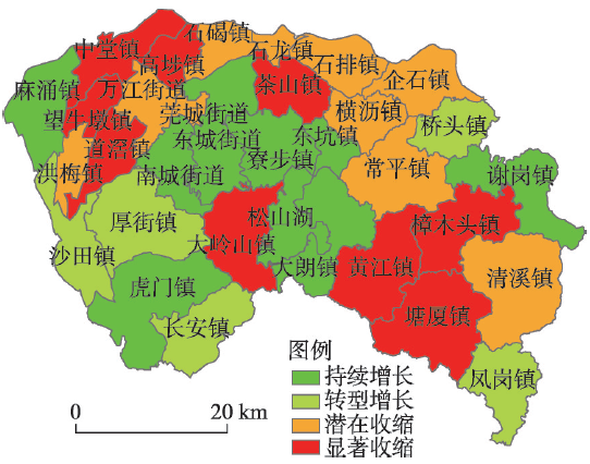
东莞城镇增长与收缩空间集中度比较明显,总体呈现“中部增长——西北部、东南部收缩”的空间分布特征(图3)。中部丘陵片区的南城街道、东城街道、寮步镇、松山湖、大朗镇和东坑镇6个镇街,同属于持续增长类型城镇,共同组成了东莞市域范围的增长城镇集中片区。潜在收缩类型的城镇主要集中北部与广州、惠州接壤的边界地区,石碣镇、石龙镇、石排镇和企石镇形成了潜在收缩城镇集中片区。与此同时,位于西北部水乡片区的中堂镇、高埗镇、望牛墩镇和道滘镇,以及位于东南部山区片区的樟木头镇、黄江镇和塘厦镇,成为两个显著收缩城镇集中区域。
图3 2008-2014年东莞增长城镇与收缩城镇的空间分布
Fig. 3 Distribution of growing and shrinking towns in Dongguan in 2008-2014
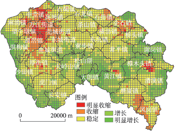
图4 基于1 km×1 km夜间灯光数据的2008-2014年东莞增长空间与收缩空间分布
Fig. 4 Distribution of growth and shrinkage based on 1 km×1 km DMSP/OLS data in Dongguan in 2008-2014
DMSP/OLS夜间灯光数据变化同样呈现出中部增长、西北部和东南部收缩的分布特征,与镇街单元的增长与收缩分布基本一致(图4)。从1 km×1 km的空间尺度可以看出,部分转型增长类型城镇(如:厚街镇和凤岗镇)的内部出现类似于欧美国家的“穿孔状”收缩,其成因主要是在推进生产自动化和服务业转型过程中,由于劳动人口数量减少导致镇街单元社会经济活动强度下降,出现厂房和出租屋空置为特征的收缩空间。
此外,后危机时期东莞城镇发展呈现一定的中心化趋势,围绕“东莞的科技中心”松山湖为中心,周边 1 km×1 km空间网格的夜间灯光亮度呈现明显增长,反映出松山湖对经济要素和人口要素的集聚具有强大吸引力,正在成为东莞城镇发展的新增长极。随着松山湖的中心性持续增强,东莞自1978年以来以镇街单元主导的发展模式将出现新变化,以往“村村点火、户户冒烟”的发展格局将得到改变,真正意义的城市中心将逐步形成。
由此,本文选择松山湖、长安镇、常平镇和望牛墩镇作为典型城镇,分别代表持续增长、转型增长、潜在收缩和显著收缩四种不同类型的城镇(表1)。其中,松山湖是后危机时期东莞的新“增长极”,经济、人口和用地均实现了持续增长;长安镇是传统的加工制造业重镇,也是后危机时期成功实现转型升级的代表性城镇;常平镇虽然城镇发展起步较早,但由于主导产业处于竞争劣势并且缺乏明确转型路径,城镇发展面临着收缩的风险;望牛墩镇位于东莞收缩城镇集中的西北部水乡片区,也是期间出现收缩次数最多的显著收缩类型代表城镇。
表1 东莞不同类型城镇的主要特征与所属镇街
Tab. 1 Characteristics and administrative divisions of different types of towns in Dongguan
| 城镇类型 | 主要特征 | 所属城镇 |
|---|---|---|
| 持续增长 | 通过传统制造业与现代服务业结合,或推动先进制造业升级,不断吸引资本要素和人口要素的流入,实现了经济、人口和用地三者良性循环; | 松山湖、东城街道、南城街道、虎门镇、麻涌镇、厚街镇、大朗镇、谢岗镇、东坑镇 |
| 转型增长 | 受到金融危机影响出现人口收缩,通过“机器换人”和技术创新的方式,推动劳动密集型产业转型升级,实现了经济的重新增长; | 长安镇、寮步镇、沙田镇、凤岗镇、桥头镇 |
| 潜在收缩 | 主导产业处于比较劣势,缺乏明确的城镇转型方向路径,虽然城镇人口数量保持稳定,但经济指标持续下滑面临着收缩的风险; | 常平镇、清溪镇、横沥镇、企石镇、石排镇、石龙镇、石碣镇、洪梅镇、莞城街道、万江街道 |
| 显著收缩 | 城镇原有经济与人口基础较薄弱,金融危机冲击过后城镇收缩凸显,在经济指标低增速的同时,人口数量持续出现负增长。 | 望牛墩镇、道滘镇、中堂镇、高埗镇、茶山镇、大岭山镇、黄江镇、塘厦镇、樟木头镇 |
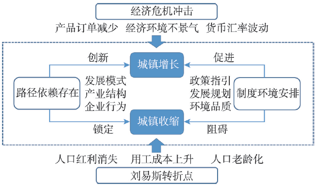
围绕低廉土地和劳动力要素形成的比较优势(Comparative Advantage),以及改革开放后国家通过制度创新(Institutional Innovation)产生的政策激励,被视为东莞“外向型城镇化”的理论来源。然而,2008年金融危机前后东莞城镇发展的外部环境和内在条件发生显著变化:一方面,在金融危机冲击和刘易斯转折点的双重影响下,以往无限供给的外来资本和转移劳动力等外部条件发生根本性的逆转,原有劳动力和土地等低成本的比较优势逐渐消失;另一方面,城镇发展的路径依赖与制度安排,地方政府既可能积极采取创新策略为地方应对外部冲击提供政策支持与制度保障,也可能由于缺乏创新陷入路径锁定从而制约地方的可持续发展,面临持续的城镇收缩。
本文结合松山湖、长安镇、常平镇和望牛墩镇4个典型城镇案例,分别从经济危机冲击、刘易斯转折点、路径依赖存在、制度环境安排四个方面(图5),分析和探讨快速城镇地区城镇增长与收缩的形成机制。
图5 快速城镇化地区增长与收缩形成机制
Fig. 5 Mechanisms of urban growth and shrinkage in rapidly-urbanizing area
经济危机的爆发冲击地方实体经济的同时,引发了一系列循环累积因果的反面效应[38]:经济环境的不景气导致企业倒闭加剧、就业岗位减少,失业和非充分就业引起低收入和贫困的增加,继而造成人口外迁,导致地方厂房建筑空置、基础设施衰败和社区日渐衰落等城市收缩现象的出现。2008年金融危机对东莞的冲击在经济、人口和用地三个维度的具体表现为:企业倒闭加剧、产业人口外流、厂房出租屋空置。相关部门数据显示,2008-2009年间东莞全市制造业企业登记注销达到1285家,同时企业用工备案总人数和出租屋登记备案数分别减少45.26万人和1.86万宗。
王缉慈教授将东莞的外向型加工制造业比喻为松脚型工业(Footloose Industry),指出随着政策、市场等区位条件改变,这些松脚型工业很容易选择倒闭或外迁造成空洞 化[39]。显而易见,“穿孔状”收缩即空洞化在城镇空间范畴的物理表现。除持续增长的松山湖以外,其他三个城镇案例均出现不同程度的空置现象:长安镇虽然实现经济的转型,但人口规模至今尚未恢复至金融危机前的水平,出租屋空置率普遍达到15%~25%;常平镇由于经济的持续放缓,出租屋的整体空置率从2008年的18%增加至2013年的35%,同期出租屋平均月租金从423元下降至406元;而望牛墩镇则面临持续的经济低增长和人口规模萎缩,出租屋空置率甚至高达37%,可见快速城镇化地区城镇的出租屋空置率与其收缩严重程度呈现正相关关系。
相比较而言,作为“东莞的科技中心”的松山湖,自园区设立之初便明确以技术创新为城镇发展的核心要素,以高新技术企业和高素质人才的集聚驱动城镇的持续增长,避免了金融危机的冲击。松山湖产业结构占比中85.89%为高端电子信息业,拥有本科以上学历的从业人口占比达到了26.62%。在创新驱动下,松山湖2008-2014年间实现了GDP和常住人口年均22.91%和23.68%的高速增长,特别是2008年金融危机冲击下经济仍然保持30.58%的增长,创造了后危机时期经济发展的东莞速度。由此可见,依靠技术进步和人力资本“内生式发展模式”有助于避免金融危机对地方经济的冲击保持城镇的持续增长。
转移劳动力与国外资本为珠江三角洲的“增长奇迹”提供了持续动力,而且劳动力(尤其是外来人口)的贡献甚至大于资本的贡献[40],数以百万计的内地农村剩余劳动力转移造就了东莞的外向型城镇化。然而,随着人口刘易斯转折点[41]的到来,中国的劳动年龄人口即将进入负增长阶段,城镇人口结构中劳动力无限供给的状况已经发生逆转,严重影响制造业尤其是外向型加工企业的可持续经营。
刘易斯转折点带来的人口红利问题对东莞的影响尤为深刻,在东莞社会保障登记人口中,15~64岁劳动年龄人口所占比重在2010年达到峰值(94.54%)后,连续多年下降至2014年的93.18%,与中国人口刘易斯转折点的判断基本吻合。此外,用工荒现象与农民工工资上涨的刘易斯转折点的标志性特征[41]也已经出现。一方面,早在2004年春季“民工荒”便频繁见于东莞相关新闻媒体报道之中,相关资料显示东莞的用工缺口超过10万人,主要集中在电子、餐饮、住宿、鞋业、五金模具、服装制衣等行业(http://finance.cnr.cn/gundong/201402/t20140228_514955427.shtml);另一方面,企业用工的最低工资标准已经从2008年的770元/月增加至2015年的1510元/月,年均增长超过10%,根据调研企业反映算上企业社保、房租、伙食、水电等费用,企业用工平均人力成本将超过5000元,给企业生产经营造成极大的压力。
以长安镇为代表的传统制造业重镇,积极通过“机器换人”手段有效地解决了企业“用工荒”、“用工贵”的问题。从2014年开始长安镇政府每年安排300万元专项资金鼓励企业“机器换人”,同时牵头组织成立东莞市机器人产业协会,协助全市“机器换人”企业资助和奖励的认定。仅2014-2015年间,长安镇参与机器换人的项目占全市的比重达12.35%,实现减员绩效指标10018人,一定程度上避免由于人口收缩造成的劳动力短缺问题。通过自动化手段对企业生产环节进行改造,提升产品生产效率和节约劳动力成本,有效地应对人口红利消失所带来的影响,是后金融危机时期长安镇实现产业经济转型的主要手段。
受到历史沿袭和惯例的作用,地方和区域的发展轨迹具有很强的路径依赖性[42-43],由于惯性的作用会使得依赖不断自我强化,路径依赖的存在很大程度上成为地方发展前景和轨迹的决定性因素。具有转折性的创新实践(如:技术创新、制度创新)能够打破城镇发展路径依赖实现成功“解锁”[44],相反若城镇发展仅仅遵循特定的轨迹运行,便容易陷入路径“锁定”的困局。
东莞城镇发展普遍存在对土地资源消耗和对物业租赁经济的路径依赖,随着政府层面加强土地供给的调控,各城镇均面临土地资源不足的状况,而经济放缓和人口收缩也使得原有的租赁经济效益难以为继。收缩城镇案例中,强烈的路径依赖使得常平镇难以实现转型,更多地依靠其经济惯性维持发展:通过发展电子信息业和房地产业较早地实现了城镇化起步的常平镇,多次尝试向生物信息、现代物流、珠宝玉石等方向转型,但其产业结构尚未产生本质性改变,在金融危机冲击下城镇发展面临极大的收缩风险;而望牛墩镇的主导产业印刷包装业比较优势不明显,作为财政收入来源的村镇租赁经济越发乏力,部门访谈中了解到,由于对基础设施硬件和公共服务缺乏足够的资金投入,城镇发展很可能面对持续的经济低迷和人口流失。
通过具有转折性的创新实践(制度创新和技术创新)是城镇摆脱路径依赖实现转型增长的关键。2008年长安镇确定成为“产业结构调整和转型升级综合试点镇”后,从制度层面上镇政府专门成立7个工作小组专门推进产业升级,面对传统“两头在外”代工模式已经逐渐失去竞争力,长安镇通过改变企业性质和优化产业结构促进企业的转型:一方面,推动“三来一补”向“三资”企业或民营企业转变,开拓国内市场减轻对外部需求的依赖,2008-2014年间长安镇来料加工企业减少了452家,而同期“三资”企业数量增加了254家。另一方面,长安镇通过减少服装、毛织、玩具、塑胶等传统制造业的占比,不断增强机械五金模具和电子信息两大特色产业的规模,2008-2013年间长安镇电子信息产业和五金模具产业的比重分别增加4.81%和2.88%。
制度主义理论将制度结构和制度形式作为解释促进或抑制地方和区域发展和经济增长的基础条件。制度环境与制度安排的差异,表明地方和区域吸收和创造技术进步的能力不同,进而决定了地区之间经济表现的差异[45-46]。政策环境的支撑作用有助于城镇避免持续衰退和实现转型增长,同时也可能对城镇的可持续发展产生消极的限制。
松山湖在成立之初便得到东莞市政府高度重视,在不同层面出台推动园区产业配套、用地出让、企业孵化、人才引进等方面的优惠性政策和鼓励性指引,企业用工薪酬待遇相比其他镇街拥有15%~20%的比较优势,持续创造政策制度红利提升园区的综合竞争力。同时,良好的制度环境和完善的基础设施配套有助于松山湖人口结构的提升,2008年以来松山湖15~24岁年龄段的人口比重和拥有大学以上高等学历人口比重分别增加了20.64个百分点和8.02个百分点,人口结构不断向年轻化和高学历化方向优化。
与之相对,显著收缩的望牛墩镇则面临不同层面制度环境的约束:首先,市政府层面关于清退水乡片区“两高一低”污染企业的规定,对以印刷包装业为主导产业的望牛墩镇造成巨大冲击,仅2014年望牛墩镇清退企业的用工规模占全镇用工人数的4.23%;其次,2013年出台的《广东东莞水乡特色发展经济区城乡总体规划》规定城镇生活区范围内限制发展所有工业,与始建于2002的中韩桥工业园的用地现状造成明显的矛盾,新引进的工业项目由于不能通过环评而无法落地,企业退出后空置土地无法承接新项目,从业人口大量流失的同时造成建设用地的极大浪费。
东莞作为快速城镇化的代表一直都是学界关注的焦点,2008年金融危机前后东莞市域范围内城镇的增长与收缩并存成为城镇发展的常态性特征,增长城镇与收缩城镇的空间分布有较高集中度,呈现“中部增长—西北部、东南部收缩”的总体特征,松山湖作为东莞的新增长极正逐渐改变其城市的空间发展格局。增长类型城镇经济规模和人口规模得到提升的同时,经济结构和人口结构也分别向高端化、自动化和年轻化、高学历化的方向优化;收缩类型城镇则呈现经济增速放缓、企业倒闭增加、人口流出加剧,并伴随着基础设施闲置和出租屋空置率上升等标志性现象。金融危机前后城镇外部环境和内在条件的一系列变化:经济危机对实体经济造成的巨大冲击、刘易斯转折点引发的人口红利消失、城镇发展所存在的路径依赖问题以及制度环境安排对城镇的支撑或限制作用,共同影响着快速城镇化地区的增长与收缩。
与欧美发达国家高度城市化不同,发展中国家的城市化进程才刚刚步入成熟阶段,经济危机冲击下发展中国家快速城镇化地区的局部收缩现象,能够为世界范围内收缩城市的研究提供新的思路与经验。回顾城市发展史不难发现世界上每个城市都有其衰落时期和收缩时期,发展中国家城市的增长与收缩是否与经济发展周期存在某种关联?人口收缩现象是短暂性的还是持续性的?其城镇收缩的动因与机制与发达国家城市有何区别?本文在揭示中国同样存在收缩城市的基础上,随后将持续跟踪和深化收缩城镇的发展过程、空间格局与形成机制,为世界收缩城市研究提供重要经验。同时我们也发现,区域内不同城市之间的增长与收缩是同时发生的,什么因素导致某些城镇能抵御外部环境变化的冲击保持持续增长?拥有“韧性”(Resilience)[47-48]的城市具备哪些产业、人口、社会、环境、文化方面的特征?受冲击的城镇如何提高“韧性”实现转型发展?上述问题需要后续研究进行回应。
The authors have declared that no competing interests exist.
| [1] |
Regional powerhouse: The Greater Pearl River Delta and the rise of China. https://doi.org/10.1111/j.1467-8306.2006.00517_9.x URL [本文引用: 1] 摘要
Includes bibliographical references and index
|
| [2] |
|
| [3] |
Exo-urbanization: The case of the Zhujiang River Relta. https://doi.org/10.11821/xb199703001 URL 摘要
城市化的研究历来都偏重于内力的营造,例如区域经济的不同发展步伐,乡村-市的人口流动,政府的地区性经济政策以及新城市的建设等。在资本、人力、技术和市场走向“全球化”的情况下,新的国际分工自1980年以来已成为一些发展中国家和地区的人口及经济活动急剧增长与集中的主要动力。本文对这一类型城市化的特点和空间形态作出了概括性的描述。
外资: 发展中国家城市化的新动力: 珠江三角洲个案研究 .https://doi.org/10.11821/xb199703001 URL 摘要
城市化的研究历来都偏重于内力的营造,例如区域经济的不同发展步伐,乡村-市的人口流动,政府的地区性经济政策以及新城市的建设等。在资本、人力、技术和市场走向“全球化”的情况下,新的国际分工自1980年以来已成为一些发展中国家和地区的人口及经济活动急剧增长与集中的主要动力。本文对这一类型城市化的特点和空间形态作出了概括性的描述。
|
| [4] |
Peri-urbanism in globalizing China: A study of new urbanism in Dongguan. https://doi.org/10.2747/1538-7216.47.1.28 URL 摘要
This study examines "peri-urbanism" (urban growth in regions surrounding or between major metropolitan centers) in post-Mao China, based on detailed study of Dongguan in the Pearl River Delta. Conditions facilitating peri-urbanism and influencing its location include relaxed state control over population mobility; spontaneous, bottom-up expansion of rural industry; and spread of global capitalism. The paper also investigates roles played by entrepreneurial local government, kinship ties/personal connections with overseas investors, collective land ownership, and access to capital, technology, and information from nearby metropolitan centers. The author presents evidence that peri-urbanism is a hybrid, path-dependent, and locally constitutive process. 8 figures, 4 tables, 57 references. Journal of Economic Literature, Classification Numbers: F21, J61, O15, O18, R52.
|
| [5] |
Review and preview of the urbanization in Pearl River Delta in the past 30 years of reform and opening up.
改革开放30年见证了珠江三角洲瞩目的工业化和城镇化成就。农村城镇化是珠三角在当时全国展现的一种全新城镇化现象,其中,农业发展和农村改革是农村城镇化的初始动力,对外开放是农村城镇化的加速器,而国家执行的有关政策,是实现农村城镇化关键的激励因素。在这30年之间,珠三角城镇化的空间模式从“小集聚,大分散”向“大集聚,小分散”的格局演变,城镇空间演变的动力也由原有的外商直接投资向政府主导的基础设施投资转变。展望珠三角的未来,产业升级和城市转型是珠江三角洲的必然趋势,同时珠港合作格局也将发生相应的变化,以广州和香港两大城市为核心的环珠江口多中心巨型城市区域必将以全新姿态崛起于世界地理版图之上。
改革开放30年珠江三角洲城镇化的回顾与展望 .
改革开放30年见证了珠江三角洲瞩目的工业化和城镇化成就。农村城镇化是珠三角在当时全国展现的一种全新城镇化现象,其中,农业发展和农村改革是农村城镇化的初始动力,对外开放是农村城镇化的加速器,而国家执行的有关政策,是实现农村城镇化关键的激励因素。在这30年之间,珠三角城镇化的空间模式从“小集聚,大分散”向“大集聚,小分散”的格局演变,城镇空间演变的动力也由原有的外商直接投资向政府主导的基础设施投资转变。展望珠三角的未来,产业升级和城市转型是珠江三角洲的必然趋势,同时珠港合作格局也将发生相应的变化,以广州和香港两大城市为核心的环珠江口多中心巨型城市区域必将以全新姿态崛起于世界地理版图之上。
|
| [6] |
The spatial distribution and mechanism of city shrinkage in the Pearl River Delta .https://doi.org/10.3969/j.issn.1009-6000.2015.09.005 URL [本文引用: 1] 摘要
城镇收缩现象早在20世纪中期已于欧美国家出现,珠江三角洲作为“增长的奋迹”地区也同样面临城镇人口的局部收缩,尤其是金融危机后城镇的收缩现象加剧。本文利用人口普查数据和统计年鉴数据,从镇街单元和区县单元来考察珠三角地区城镇收缩的空间分布:并以东莞茶山为案例,从劳动力供给和产业需求的角度构建了基于产业结构调整和人口结构变化的城镇收缩分析框架;考察了王朱三角地区城镇收缩特征及其形成机制。研究发现:(1)珠三角核心区以局部城镇收缩为主,收缩相对集中的城镇分布在外圈层,并形成三大城镇收缩集聚区域:(2)经济增速持续放缓、外来人口总量减少是珠三角城镇收缩的典型特征;(3)产业结构需求变化与劳动力供给结构变化的不匹配造成珠三角的城镇收缩。
珠江三角洲城镇收缩的空间分布与机制 .https://doi.org/10.3969/j.issn.1009-6000.2015.09.005 URL [本文引用: 1] 摘要
城镇收缩现象早在20世纪中期已于欧美国家出现,珠江三角洲作为“增长的奋迹”地区也同样面临城镇人口的局部收缩,尤其是金融危机后城镇的收缩现象加剧。本文利用人口普查数据和统计年鉴数据,从镇街单元和区县单元来考察珠三角地区城镇收缩的空间分布:并以东莞茶山为案例,从劳动力供给和产业需求的角度构建了基于产业结构调整和人口结构变化的城镇收缩分析框架;考察了王朱三角地区城镇收缩特征及其形成机制。研究发现:(1)珠三角核心区以局部城镇收缩为主,收缩相对集中的城镇分布在外圈层,并形成三大城镇收缩集聚区域:(2)经济增速持续放缓、外来人口总量减少是珠三角城镇收缩的典型特征;(3)产业结构需求变化与劳动力供给结构变化的不匹配造成珠三角的城镇收缩。
|
| [7] |
Die schrumpfende Stadt und die Stadtsoziologie In Soziologische Stadtforschung. |
| [8] |
Shrinking Cities, International Research, Vol. 1. Ostfildern, |
| [9] |
Shrinking cities: Urban challenges of globalization. https://doi.org/10.1111/j.1468-2427.2011.01092.x URL PMID: 22518881 [本文引用: 3] 摘要
Abstract Urban shrinkage is not a new phenomenon. It has been documented in a large literature analyzing the social and economic issues that have led to population flight, resulting, in the worse cases, in the eventual abandonment of blocks of housing and neighbourhoods. Analysis of urban shrinkage should take into account the new realization that this phenomenon is now global and multidimensional 芒聙聰 but also little understood in all its manifestations. Thus, as the world's population increasingly becomes urban, orthodox views of urban decline need redefinition. The symposium includes articles from 10 urban analysts working on 30 cities around the globe. These analysts belong to the Shrinking Cities International Research Network (SCIRN), whose collaborative work aims to understand different types of city shrinkage and the role that different approaches, policies and strategies have played in the regeneration of these cities. In this way the symposium will inform both a rich diversity of analytical perspectives and country-based studies of the challenges faced by shrinking cities. It will also disseminate SCIRN's research results from the last 3 years.
|
| [10] |
Conceptualizing urban shrinkage. https://doi.org/10.1068/a46269 URL [本文引用: 3] |
| [11] |
Errors expected: Aligning urban strategy with demographic uncertainty in shrinking cities. https://doi.org/10.1080/13563470802519097 URL [本文引用: 1] 摘要
At the beginning of the 21st century, the majority of Europe's cities experienced a population decrease. Dealing with the results of demographic, economic and physical contraction processes and planning for the future of considerably smaller but nevertheless livable cities presents some of the most challenging tasks for urban Europe in the near future. This article highlights the example of Dresden in Eastern Germany, where the breakdown of the state-directed economy caused economic decline, industrial regression, and high unemployment rates. Due to out migration and decreasing birth rates, the city lost 60,000 of its 500,000 residents within one decade. As a consequence, there were housing and office vacancies as well as infrastructure oversupplies. Yet the administrative system was still directed towards growth objectives throughout the 1990s. Only after 2000 this situation changed dramatically. The new strategic plan for Dresden is no longer growth oriented. Instead, it focuses on a model of the compact 鈥楨uropean city鈥, with an attractive urban centre, reduced land consumption, and a stable population. However, in another unexpected turn of events, within the last seven years the city has experienced an unexpected growth of 25,000 residents. Surprisingly, processes of suburbanization have turned into processes of reurbanization. Today in Dresden, areas of shrinkage and decline are in close proximity to prospering and wealthy communities. The strategic challenge is to deal with this patchwork while accepting that the future remains unpredictable. Hence, strategic flexibility becomes more important than the strategy itself. To a certain extent rational analysis and error prevention is displaced by preparedness, robustness, and resilience as key qualifications of planning in shrinking cities.鈥營 am grateful to the members of the Shrinking Cities International Research Network (SCiRNTM), in particular Sylvie Fol and Cristina Martinez-Fernandez, for instructive discussions on various aspects of shrinking cities and to anonymous referees for their helpful comments and suggestions on an earlier draft. 鈥營 am grateful to the members of the Shrinking Cities International Research Network (SCiRNTM), in particular Sylvie Fol and Cristina Martinez-Fernandez, for instructive discussions on various aspects of shrinking cities and to anonymous referees for their helpful comments and suggestions on an earlier draft.
|
| [12] |
Greening the rust belt: A green infrastructure model for right sizing America's shrinking cities. https://doi.org/10.1080/01944360802354956 URL [本文引用: 1] 摘要
Problem: Existing planning and redevelopment models do not offer a holistic approach for addressing the challenges vacant and abandoned properties create in America's older industrial cities, but these shrinking cities possess opportunities to undertake citywide greening strategies that convert such vacant properties to community assets. Purpose: We define strategies shrinking cities can use to convert vacant properties to valuable green infrastructure to revitalize urban environments, empower community residents, and stabilize dysfunctional real estate markets. To do this we examine shrinking cities and their vacant property challenges; identify the benefits of urban greening; explore the policies, obstacles, and promise of a green infrastructure initiative; and discuss vacant property reclamation programs and policies that would form the nucleus of a model green infrastructure right-sizing initiative designed to stabilize the communities with the greatest level of abandonment. Methods: We draw our conclusions based on fieldwork, practitioner interviews, and a review of the current literature. Results and conclusions: We propose a new model to effectively right size shrinking cities by (a) instituting green infrastructure plans and programs, (b) creating land banks to manage the effort, and (c) building community consensus through collaborative neighborhood planning. Our model builds on lessons learned from successful vacant property and urban greening programs, including nonprofit leadership and empowerment of neighborhood residents, land banking, strategic neighborhood planning, targeted revitalization investments, and collaborative planning. It will require planners and policymakers to address challenges such as financing, displacement of local residents, and lack of legal authority. Takeaway for practice: We conclude that academics, practitioners, and policymakers should collaborate to (a) explore alternative urban designs and innovative planning and zoning approaches to right sizing; (b) collect accurate data on the number and costs of vacant properties and potential savings of different right-sizing strategies; (c) craft statewide vacant property policy agendas; and (d) establish a policy network of shrinking cities to share information, collaboratively solve problems, and diffuse policy innovations. Research support: Our field work was supported by technical assistance grants and contracts through the National Vacant Properties Campaign.
|
| [13] |
East European cities: Patterns of growth and decline, 1960-2005. https://doi.org/10.1080/13563470802518958 URL [本文引用: 3] 摘要
The paper examines the long-term population trajectories of East European cities and analyses how their fortunes have changed, both in relation to their past growth profiles and to other settlements. The main finding is that the absolute and relative positions of cities have declined sharply since the 1960s and 1970s. During the last decade the population of three-quarters of cities has been contracting, and slightly faster on average than the overall population. The immediate explanation for the downturn appears to be general demographic decline, including a fall in the fertility rate and international out-migration, rather than specific urban factors. Some places have fared less badly than others, including many of the capital cities and the principal centres of rural regions.
|
| [14] |
Shrinking cities in Australia, Japan, Europe and the USA: From a global process to local policy responses. https://doi.org/10.1016/j.progress.2014.10.001 URL [本文引用: 3] 摘要
Shrinking cities can be considered as the most critical manifestation of demographic change; a key challenge for societies together with globalisation, knowledge/technological shift, climate change and the development of the green economy. The social dynamics of shrinking cities also need special attention as the challenges involved on fighting against poverty and social exclusion in cities and regions of economic decline particularly affects those more vulnerable. The three regions featured in this work 鈥 Asia-Pacific, Europe and North America 鈥 show the spread of the phenomenon across different economic context and how the planning discipline has dealt with urban decline in the countries. The lessons found in the case studies discussed here show the phenomenon is global but anchored at the local level in its particular manifestations. This symposium argues that policy responses need to consider both the global forces behind shrinkage today and the local context where particular characteristics are found. There are however three common areas where shrinking cities can focus their strategies and programmes: community resilience; urban regeneration strategies; and tackling the social effects of demographic changes.
|
| [15] |
Urban shrinkage in Germany and the USA: A comparison of transformation patterns and local strategies. https://doi.org/10.1111/j.1468-2427.2011.01095.x URL PMID: 22518884 [本文引用: 3] 摘要
Abstract Top of page Abstract Introduction Growth machines and demographic transitions: the role of economics and demography Shrinking cities in Germany — in the vanguard of a paradigm shift? Shrinking cities in the USA — old wine in new bottles? Refining the terms of the shrinking cities debate Conclusions References Abstract Many American and European cities have to deal with demographic and economic trajectories leading to urban shrinkage. According to official data, 13% of urban regions in the US and 54% of those in the EU have lost population in recent years. However, the extent and spatial distribution of declining populations differ significantly between Europe and the US. In Germany, the situation is driven by falling birth rates and the effects of German reunification. In the US, shrinkage is basically related to long-term industrial transformation. But the challenges of shrinking cities seldom appeared on the agendas of politicians and urban planners until recently. This article provides a critical overview of the development paths and local strategies of four shrinking cities: Schwedt and Dresden in eastern Germany; Youngstown and Pittsburgh in the US. A typology of urban growth and shrinkage, from economic and demographic perspectives, enables four types of city to be differentiated and the differences between the US and eastern Germany to be discussed. The article suggests that a new transatlantic debate on policy and planning strategies for restructuring shrinking cities is needed to overcome the dominant growth orientation that in most cases intensifies the negative consequences of shrinkage. Résumé De nombreuses grandes villes américaines et européennes sont confrontées à des trajectoires démographiques et économiques conduisant à un ‘rétrécissement’ urbain. Selon des données officielles, 13% des régions métropolitaines aux 07tats-Unis et 54% dans l'UE ont vu leur population diminuer sur la période récente. Toutefois, l'ampleur et la répartition spatiale de ce déclin divergent nettement entre les deux zones géographiques. En Allemagne, la situation tient à la chute des taux de natalité et aux conséquences de la réunification. Aux 07tats-Unis, le ‘rétrécissement’ est surtout liéà une mutation industrielle sur le long terme. Or, les problèmes des villes en décroissance ont rarement figuré dans les programmes des hommes politiques ou des urbanistes, du moins jusqu’à ces dernières années. Cet article donne un aper04u critique des voies de développement et des stratégies locales de quatre villes en décroissance: Schwedt et Dresde dans l'est de l'Allemagne, Youngstown et Pittsburgh aux 07tats-Unis. Une typologie de la croissance et du ‘rétrécissement’ urbains, du point de vue économique et démographique, permet de distinguer quatre types de ville et d'analyser les différences entre les 07tats-Unis et l'Allemagne orientale. Un nouveau débat transatlantique sur les stratégies en matière de politiques publiques et d'aménagement concernant la restructuration des villes en décroissance semble nécessaire pour dominer l'orientation prépondérante en faveur de la croissance qui, le plus souvent, accentue les effets négatifs du ‘rétrécissement’.
|
| [16] |
Urban population loss in historical perspective: United States, 1820-2000. https://doi.org/10.1068/a40139a URL [本文引用: 1] 摘要
Employing an historical perspective, the author mounts a quantitative and theoretical assessment of population loss in the large cities of the United States. Three periods are considered: one prior to 1920 when large city population loss was aberrant; a second which captures the severe decline of the decades after World War II, and a third that encompasses the more recent shrinkage of cities. Population loss is measured in terms of prevalence, severity, and persistence and is also analyzed geographically. The author further identifies factors affecting population loss which are common and unique to each period. Although population loss has diminished, a number of cities are locked into trajectories of chronic loss, suggesting that a new phase of urbanization has yet to materialize.
|
| [17] |
Urban shrinkage and resurgence in Germany. https://doi.org/10.1177/0042098016657780 URL [本文引用: 1] 摘要
This article questions the strict parallelism of demographic and economic development in characterising urban shrinkage in Germany. As the cases of several Ruhr cities and East German cities prove, urban economic growth can be achieved thanks to the substantial presence of modern industries and business services, and despite declines in population size. Serious shrinkages of Halle, Cottbus and Schwerin are primarily due to failures in the post-industrial transformation process. Recent policy measures strongly oriented towards slowing the downsizing process of population (via e.g. urban regeneration strategies) do not appear to be sufficient for achieving urban resurgence in these cities. More active industrial policy measures are required there to create a competitive high-tech manufacturing sector, to stimulate innovation activities and to boost its growth interdependence with modern local services and R&D infrastructure.
|
| [18] |
Shrinkage in Japan//Shrinking Cities. Vol.1 International Research. |
| [19] |
Shaken, shrinking, hot, impoverished and informal: Emerging research agendas in planning. https://doi.org/10.1016/j.progress.2009.09.001 URL [本文引用: 1] 摘要
This is the second of two special issues in Progress in Planning exploring emerging research agendas in planning. It brings together scholars from diverse schools working on new areas of research and application in urban design and planning. Emergent research agendas include both novel areas of research and important shifts in the direction of a research area. The challenge for planning schools is to reflect critically on these changes and develop long-term research agendas that can better position our field in society and academia, and provide a basis from which to assess our academic programmes. The chapters in this issue display the different scales and fields of planning, including planning for: disaster recovery; climate change, especially opportunities for mitigation; shrinking cities in the First World; and rapidly urbanising informal and impoverished cities in the global South. At the same time, the chapters identify research areas that respond to major social and environmental changes. Olshansky and Chang highlight the increasing losses from catastrophic disasters, and address the need for disaster recovery planning. Wheeler, Randolph and London focus on climate change, and, noting the urgency of action now, their research agenda emphasises opportunities for planners to develop research and policies to reduce greenhouse gas emissions. Hollander, Pallagst, Schwarz and Popper look at increasing economic and population trends in many First World cities that result in city 鈥榮hrinkage鈥. They present new opportunities for improving cities鈥 green space networks and natural features, and for research. The trebling of urban population in African cities by 2050, in conditions of poverty and informality, is the major trend driving Parnell, Pietriese and Watson's chapter. They present an agenda for new planning theories and for supporting empirical research to address the actual conditions of African cities.
|
| [20] |
Shrinking city: International experience and Chinese reality .国际经验和中国现实 . |
| [21] |
Shrinking city: On searching for urban development in non-growing scenarios .
逆增长情景下的城市发展路径研究进展 .
|
| [22] |
Background, identification and feature analysis of shrinking cities in China .
城市增长和城市收缩是一枚银币的两面,以人口流失为核心特征的城市收缩现象在中国普遍存在。本文利用两次人口普查数据,从地级及以上行政单元和县市(区)两种空间尺度,识别中国的城市收缩格局,分别从人口结构、经济结构和社会状况三个维度考察收缩县市(区)的发展状态。两次普查年间频繁的区划调整将对本文的识别结果产生重大影响,利用乡、镇、街道数据,对2865个县市(区)中涉及到行政区划变动的样本进行调整。结论显示,中国26.71%地级及以上行政单元、37.16%县市(区)发生收缩,以中国东北地区和长江经济带的收缩最为严重,且集中出现了"市区—市辖区"双收缩的现象。通过分析,与非收缩县市(区)相比,收缩县市(区)经济社会发展水平较低,集中体现为:较高的人口抚养比、单一的行业结构、较低的城市化率,以及较低的人力资本存量。
中国城市收缩的背景、识别与特征分析 .
城市增长和城市收缩是一枚银币的两面,以人口流失为核心特征的城市收缩现象在中国普遍存在。本文利用两次人口普查数据,从地级及以上行政单元和县市(区)两种空间尺度,识别中国的城市收缩格局,分别从人口结构、经济结构和社会状况三个维度考察收缩县市(区)的发展状态。两次普查年间频繁的区划调整将对本文的识别结果产生重大影响,利用乡、镇、街道数据,对2865个县市(区)中涉及到行政区划变动的样本进行调整。结论显示,中国26.71%地级及以上行政单元、37.16%县市(区)发生收缩,以中国东北地区和长江经济带的收缩最为严重,且集中出现了"市区—市辖区"双收缩的现象。通过分析,与非收缩县市(区)相比,收缩县市(区)经济社会发展水平较低,集中体现为:较高的人口抚养比、单一的行业结构、较低的城市化率,以及较低的人力资本存量。
|
| [23] |
Concept, mechanism and planning suggestions of shrinking city: A perspective of capital flows from Neo-Marxism .
以人口减少和经济衰退为特征的收缩城市,近年来已经引起国内外城市规划学者的广泛关注。文章基于新马克思主义城市理论,从资本流动的角度对城市收缩的概念、形成及类型进行解释,在分析资本流动与城市发展关系的基础上,提出收缩城市是过度积累危机的空间表现,而过度积累危机中出现的资本盈余和劳动盈余是导致城市出现收缩的主要动因。同时,根据经济全球化资本流动的特征,分别从依附关系、制造业转移、郊区化和地方制度响应四个方面分析不同类型收缩城市的形成机制,进而从规划方向指出收缩城市对我国城市发展的启示。
收缩城市的形成与规划启示: 基于新马克思主义城市理论的视角 .
以人口减少和经济衰退为特征的收缩城市,近年来已经引起国内外城市规划学者的广泛关注。文章基于新马克思主义城市理论,从资本流动的角度对城市收缩的概念、形成及类型进行解释,在分析资本流动与城市发展关系的基础上,提出收缩城市是过度积累危机的空间表现,而过度积累危机中出现的资本盈余和劳动盈余是导致城市出现收缩的主要动因。同时,根据经济全球化资本流动的特征,分别从依附关系、制造业转移、郊区化和地方制度响应四个方面分析不同类型收缩城市的形成机制,进而从规划方向指出收缩城市对我国城市发展的启示。
|
| [24] |
Urbanization and growth. https://doi.org/10.1016/j.jue.2004.03.003 URL [本文引用: 1] |
| [25] |
Urbanization, agglomeration, and economic development. https://doi.org/10.1016/j.actbio.2006.08.004 URL [本文引用: 1] 摘要
CHAPTER 4 Urbanization, Agglomeration, and Economic Development John M. Quigley In 2007 the United Nations Population Fund released a report forecasting rapidly rising levels of urbanization over the next two decades, especially in the developing world. It noted that for the 03rst time in history, more than half the world’s population resides in urban areas. The same year UN- HABITAT issued a report highlighting the slums and deplorable living con- ditions in cities in developing countries. That report (UN-HABITAT 2007) estimated that by the end of 2007 there would be more than 1 billion slum dwellers, most of them living in developing countries. It claims that in many cases the economic circumstances of urban migrants are worse than those of rural peasants. In 2003 the United Nations surveyed member govern- ments eliciting their attitudes toward urbanization. It found that the “vast majority” of these governments would have liked to shift populations back to rural areas and to stem the tide of urbanization. Is urbanization actually bad for development? If life in urban areas were worse for urban dwellers than the life they left behind, presumably they would leave the city. So why all the fuss about urbanization and development? The author is grateful to Patricia Annez and Robert Buckley for their comments, as well as to Vernon Henderson and Stephen Malpezzi. John M. Quigley GCU_04pp115-132.indd 115 9/18/08 4:18:56 PM
|
| [26] |
The New Imperialism . |
| [27] |
The Limits to Capital (New and Fully Updated Edition). |
| [28] |
Planning for the global cities: The endogenous development model.
探讨城市发展的合理模式.通过对城市发展的两种模式(城市营销模式和内生式发展模式)的比较,提出城市发展必须主要基于内部的资源和动力而不是与外部的竞争,城市间应通过合作形成城市网络,以达到城市区域的共同繁荣.
规划全球城市: 内生式发展模式 .
探讨城市发展的合理模式.通过对城市发展的两种模式(城市营销模式和内生式发展模式)的比较,提出城市发展必须主要基于内部的资源和动力而不是与外部的竞争,城市间应通过合作形成城市网络,以达到城市区域的共同繁荣.
|
| [29] |
Urban shrinkage and resurgence in Germany. https://doi.org/10.1177/0042098016657780 URL [本文引用: 1] 摘要
This article questions the strict parallelism of demographic and economic development in characterising urban shrinkage in Germany. As the cases of several Ruhr cities and East German cities prove, urban economic growth can be achieved thanks to the substantial presence of modern industries and business services, and despite declines in population size. Serious shrinkages of Halle, Cottbus and Schwerin are primarily due to failures in the post-industrial transformation process. Recent policy measures strongly oriented towards slowing the downsizing process of population (via e.g. urban regeneration strategies) do not appear to be sufficient for achieving urban resurgence in these cities. More active industrial policy measures are required there to create a competitive high-tech manufacturing sector, to stimulate innovation activities and to boost its growth interdependence with modern local services and R&D infrastructure.
|
| [30] |
Shrinking cities in China .https://doi.org/10.3969/j.issn.1009-6000.2015.09.002 URL [本文引用: 1] 摘要
收缩城市的研究已经在西方国家开展多年,发生收缩的背景和原因也各有差异。作为城市发展的一个阶段,中国部分城市也发生了人口收缩。本文利用2000和2010年乡镇街道尺度的人口数据,对中国收缩城市进行了识别、分类和影响因素分析,并针对中国收缩城市自身的特点,提出初步的对策建议和规划设计应对。最后从中国收缩城市的深度探测、典型收缩城市研究、规划应对手段以及研究网络的发展四个方面提出了中国收缩城市研究的研究框架。
中国收缩城市及其研究框架 .https://doi.org/10.3969/j.issn.1009-6000.2015.09.002 URL [本文引用: 1] 摘要
收缩城市的研究已经在西方国家开展多年,发生收缩的背景和原因也各有差异。作为城市发展的一个阶段,中国部分城市也发生了人口收缩。本文利用2000和2010年乡镇街道尺度的人口数据,对中国收缩城市进行了识别、分类和影响因素分析,并针对中国收缩城市自身的特点,提出初步的对策建议和规划设计应对。最后从中国收缩城市的深度探测、典型收缩城市研究、规划应对手段以及研究网络的发展四个方面提出了中国收缩城市研究的研究框架。
|
| [31] |
The trajectories of European cities, 1960-2005. https://doi.org/10.1016/j.cities.2007.01.007 URL [本文引用: 1] 摘要
Cities have been viewed for several decades as the places within Europe typically facing the greatest problems associated with economic and population decline. A contrasting view has emerged recently that identifies cities as sites of economic dynamism and social vitality. The paper offers evidence on population change for 310 cities across the whole of Europe to assess how their fortunes have changed over the period from the 1960s through to 2005. It reveals considerable diversity of experience, with one in seven cities described as resurgent on a strict definition of decline followed by growth. They are outnumbered by cities that have experienced continuous growth and those that have had a recent downturn. Taking a long-term overview, the growth of European cities has generally slowed over the last few decades. A short-term perspective suggests something of a recovery within the last five years. Growth and revival are more common in Western Europe and decline is more widespread in the East. The position of larger cities also appears to have improved slightly relative to smaller cities.
|
| [32] |
Urban population development in Europe, 1991-2008: The examples of Poland and the UK. https://doi.org/10.1111/j.1468-2427.2012.01114.x URL [本文引用: 1] 摘要
Across Europe, there is a complex mosaic of urban population development. Characterized by great diversity and heterogeneity, this development does not follow a common pattern and cannot be attributed to specific regional trends (e.g. Eastern or Western European geographic location, or post-socialist, old industrial or developed capitalist economic models). In this article, we show how this mosaic can be explained, relating it to various driving forces and overarching processes. Using a multilevel approach and looking at the period 1991–2008, we identified various European city population growth or decline clusters; these indicated that urban population development does not necessarily follow strictly national lines. Further, we argue that similar clusters of growing and declining cities may occur within European countries as diverse as Poland and the UK. Overarching driving forces such as demographic change interfere with national specificity and the peculiarities of local settings. The most significant finding of this article is that overlapping driving forces currently lead in their interplay to diverging courses of urban population development on different spatial scales (and will probably continue to do so in future).RésuméL'évolution de la population urbaine en Europe se présente comme une mosa07que complexe. Caractérisée par une diversité et une hétérogénéitéélevées, elle n'obéit à aucun schéma commun et ne peut être attribuée à aucune tendance régionale précise (comme la situation géographique en Europe de l'Est ou de l'Ouest, ou bien les modèles économiques post-socialistes, industriels anciens ou capitalistes développés). Il est possible d'expliquer cette mosa07que en la reliant à divers facteurs moteurs et processus dominants. Une approche à plusieurs niveaux et l'étude de la période 1991–2008 permettent d'identifier différents p00les de croissance et de déclin de la population dans les villes européennes. Ceux-ci indiquent que la population urbaine ne suit pas forcément les tendances nationales. En outre, des p00les similaires de villes en croissance et en déclin peuvent exister dans des pays aussi distincts que la Pologne et le Royaume-Uni. Les dynamiques dominantes, telles que les changements démographiques, interfèrent avec la spécificité nationale et les particularités des contextes locaux. La conclusion la plus importante de ce travail est que ces dynamiques superposées viennent se conjuguer pour créer, selon l'échelon spatial, des trajectoires distinctes d'évolution de la population urbaine (ce qu'elles continueront sans doute de faire à l'avenir).
|
| [33] |
Historical trajectories of currently shrinking Portuguese cities: A typology of urban shrinkage. https://doi.org/10.1016/j.cities.2015.11.008 URL [本文引用: 1] 摘要
Cities develop according to different patterns, undergoing population growth during some periods and decline (shrinkage) during others. Theories attempting to understand these behaviours include: 1) shrinkage is a natural process in the life cycle of a city, alternating with periods of growth, or 2) shrinkage is an extreme event that places cities into a continuous decline process with no return to population growth. We use retrospective data over a period of 13002years to study 25 Portuguese cities currently facing population decline, and show that both theories coexist in time and space. Five types of shrinking city are revealed: “Persistent Early Shrinkage” due to exodus from the rural periphery, “Metropolitan Shrinkage” due to the challenges of urban sprawl, “Recent Shrinkage” in de-industrialisation hotspots, “Cyclic Shrinkage” occurring in political transformation cores, and “Mild Shrinkage” due to life-style disamenity. As diversity of city population trajectories appears to be the norm in both Portugal and other Western European countries, the incorporation of this range into the management of urban transitions is recommended in order to reinforce city resilience.
|
| [34] |
Spatial metrics to study urban patterns in growing and shrinking cities. https://doi.org/10.1080/02723638.2015.1096118 URL [本文引用: 1] 摘要
This article reviews existing literature on spatial metrics, presenting a portfolio of metrics addressing the spatial patterns of growing and shrinking cities and discussing their potential and limitations. A wide and diverse set of spatial metrics was found. While these metrics address most of the identified spatial patterns of urban growth, spatial metrics used in urban shrinkage studies are much scarcer and not nearly sufficient to provide a comprehensive assessment of its spatial patterns. The article concludes that there is great potential for the development of new spatial metrics or mixed indicators, particularly in shrinkage contexts. The article builds on recent literature focusing on reviewing and developing metrics for particular spatial patterns (notably patterns of urban sprawl), while considering a very broad and multidisciplinary set of metrics. It focuses not only on the outcomes of urban growth but also on those of the increasingly common shrinking phenomenon.
|
| [35] |
Research on quantitative calculation method of shrinking city .https://doi.org/10.3969/j.issn.1009-6000.2016.02.004 URL [本文引用: 1] 摘要
二战以后,受到郊区化、去工业化、全球化深化和社会转型等多种因素的综合影响,部分欧洲和北美城市出现了明显的经济衰退、人口衰退现象以及随之而起的城市收缩。关于城市收缩的研究多集中于其定义、成因及其规划应对。考虑到城市收缩是多种因素的复杂作用结果,仅使用人口变动(下降)来量化描述这一现象仅反映收缩城市的一个方面。基于此,本文拟对当前量化描述城市收缩的各类统计量进行梳理,考察其提出的理论逻辑及具体计算方法,为在我国开展城市收缩现象研究提供参考。
收缩城市量化计算方法进展 .https://doi.org/10.3969/j.issn.1009-6000.2016.02.004 URL [本文引用: 1] 摘要
二战以后,受到郊区化、去工业化、全球化深化和社会转型等多种因素的综合影响,部分欧洲和北美城市出现了明显的经济衰退、人口衰退现象以及随之而起的城市收缩。关于城市收缩的研究多集中于其定义、成因及其规划应对。考虑到城市收缩是多种因素的复杂作用结果,仅使用人口变动(下降)来量化描述这一现象仅反映收缩城市的一个方面。基于此,本文拟对当前量化描述城市收缩的各类统计量进行梳理,考察其提出的理论逻辑及具体计算方法,为在我国开展城市收缩现象研究提供参考。
|
| [36] |
The Nightsat mission concept. https://doi.org/10.1080/01431160600981525 URL [本文引用: 1] 摘要
Nightsat is a concept for a satellite system capable of global observation of the location, extent and brightness of night‐time lights at a spatial resolution suitable for the delineation of primary features within human settlements. Based on requirements from several fields of scientific inquiry, Nightsat should be capable of producing a complete cloud‐free global map of lights on an annual basis. We have used a combination of high‐resolution field spectra of outdoor lighting, moderate resolution colour photography of cities at night from the International Space Station, and high‐resolution airborne camera imagery acquired at night to define a range of spatial, spectral, and detection limit options for a future Nightsat mission. The primary findings of our study are that Nightsat should collect data from a near‐synchronous orbit in the early evening with 50 to 10002m spatial resolution and have detection limits of 2.5E61802Watts02cm612sr61108m611 or better. Although panchromatic low‐light imaging data would be useful, multispectral low‐light imaging data would provide valuable information on the type or character of lighting; potentially stronger predictors of variables such as ambient population density and economic activity; and valuable information to predict response of other species to artificial night lighting. The Nightsat mission concept is unique in its focus on observing a human activity, in contrast to traditional Earth observing systems that focus on natural systems.
|
| [37] |
A global poverty map derived from satellite data. https://doi.org/10.1016/j.cageo.2009.01.009 URL [本文引用: 1] 摘要
A global poverty map has been produced at 30 arcsec resolution using a poverty index calculated by dividing population count (LandScan 2004) by the brightness of satellite observed lighting (DMSP nighttime lights). Inputs to the LandScan product include satellite-derived land cover and topography, plus human settlement outlines derived from high-resolution imagery. The poverty estimates have been calibrated using national level poverty data from the World Development Indicators (WDI) 2006 edition. The total estimate of the numbers of individuals living in poverty is 2.2 billion, slightly under the WDI estimate of 2.6 billion. We have demonstrated a new class of poverty map that should improve over time through the inclusion of new reference data for calibration of poverty estimates and as improvements are made in the satellite observation of human activities related to economic activity and technology access.
|
| [38] |
McCarthy L. Urbanization: An Introduction to Urban Geography. https://doi.org/10.1038/2001267e0 URL [本文引用: 1] 摘要
Urbanization : an introduction to urban geography Paul L. Knox Prentice-Hall, c1994
|
| [39] |
|
| [40] |
Reason analysis of economic growth in Pearl River Delta .珠江三角洲经济区经济快速增长原因探析 . |
| [41] |
Demographic transition, demographic dividend, and lewis turning point in China .人口转变、人口红利与刘易斯转折点 . |
| [42] |
An evolutionary Theory of Economic Growth. Belknap-Harvard, Cambridge, |
| [43] |
Path dependence and regional economic evolution. https://doi.org/10.1093/jeg/lbl012 URL [本文引用: 1] 摘要
In recent years, economic geographers have seized on the concepts of ‘path dependence’ and ‘lock-in’ as key ingredients in constructing an evolutionary approach to their subject. However, they have tended in to invoke these notions without a proper examination of the ongoing discussion and debate devoted to them within evolutionary economics and elsewhere. Our aim in this paper, therefore, is, first, to highlight some of the unresolved issues surround these concepts, and, second, to explore their usefulness for understanding the regional economic evolution. We argue that in many important aspects, path dependence and lock-in are place-dependent processes, and as such require geographical explanation. At the same time, there has been little discussion of regional path creation: te assumption has been that new technological-economic paths emerge at random or spontaneously across space, an assumption that we find too simplistic. This leads on to the key question as to why some regional economies become locked into development paths that lose dynamism, whilst other regional economies seem able to avoid this danger and in effect are able ‘reinvent’ themselves through successive new paths or phases of development. We conclude that whilst path dependence is an important feature of the economic landscape, the concept requires further elaboration if it is to function as a core concept in an evolutionary economic geography.
|
| [44] |
A theoretical framework for evolutionary economic geography: Industrial dynamics and urban growth as a branching process. https://doi.org/10.1093/jeg/lbm018 URL [本文引用: 1] 摘要
We propose a framework that specifies the process of economic development as an evolutionary branching process of product innovations. Each product innovation provides a growth opportunity for an existing firm or a new firm, and for an existing city or a new city. One can then obtain both firm size and city size distributions as two aggregates resulting from a single evolutionary process. Gains from variety at the firm level (economies of scope) and the urban level (Jacobs externalities) provide the central feedback mechanism in economic development generating strong path dependencies in the spatial concentration of industries and the specialisation of cities. Gains from size are also expected, yet these are ultimately bounded by increasing wages. The contribution of our framework lies in providing a micro-foundation of economic geography in terms of the interplay between industrial dynamics and urban growth. The framework is sufficiently general to investigate systematically a number of stylised facts in economic geography, while at the same time it is sufficiently flexible to be extended such as to become applicable in more specific micro-contexts. A number of extensions related to the concepts of knowledge spillover and lock-in, are also discussed.
|
| [45] |
Public policies, regional inequalities and growth. https://doi.org/10.1016/S0047-2727(98)00110-8 URL [本文引用: 1] |
| [46] |
Andrés Rodríguez-Pose, John Tomaney. Handbook of Local and Regional Development. |
| [47] |
Building Urban Resilience: Principles, Tools, and Practice.
Building Urban Resilience in East Asia is a World Bank program that aims to increase the resilience of cities to disasters and the impacts of climate change by using a risk-based approach to making public investment decisions. The objective is to demonstrate a scalable methodology and practical tools for risk assessment that can be used for city-level investment decisions. Working closely with the stakeholders involved in land use planning and infrastructure development, phase one of this program identified the major challenges facing urban decision makers in terms of risks from natural disasters and climate change and now offers open-source risk assessment tools that can be used by city-level institutions, other communities, private investors, and planners of infrastructure services. Phase two explores different investment options, management plans, and capacity building needs. The goal is to formulate a strategy in which flexible and 'low-regret' measures can be cost-effective even when risks are uncertain. Taking into account future risks and uncertainties, resilience relies on redundancy. Cities facing difficult decisions about scarce resources and investments strive for efficiency. Financial approaches to urban disaster resilience should reduce the negative impacts of disasters on individuals and communities, the private sector, and public entities.
|
| [48] |
On the notion of regional economic resilience: Conceptualization and explanation. https://doi.org/10.1093/jeg/lbu015 URL [本文引用: 1] 摘要
Over the past few years a new buzzword has entered academic, political and publicdiscourse: the notion of resilience, a term invoked to describe how an entity or systemresponds to shocks and disturbances. Although the concept has been used for sometime in ecology and psychology, it is now invoked in diverse contexts, both as aperceived (and typically positive) attribute of an object, entity or system and, morenormatively, as a desired feature that should somehow be promoted or fostered. Aspart of this development, the notion of resilience is rapidly becoming part of theconceptual and analytical lexicon of regional and local economic studies: there isincreasing interest in the resilience of regional, local and urban economies. Further,resilience is rapidly emerging as an idea ‘whose time has come’ in policy debates: anew imperative of ‘constructing’ or ‘building’ regional and urban economic resilience isgaining currency. However, this rush to use the idea of regional and local economicresilience in policy circles has arguably run somewhat ahead of our understanding ofthe concept. There is still considerable ambiguity about what, precisely, is meant bythe notion of regional economic resilience, about how it should be conceptualized andmeasured, what its determinants are, and how it links to patterns of long-run regionalgrowth. The aim of this article is to address these and related questions on themeaning and explanation of regional economic resilience and thereby to outline thedirections of a research agenda.
|

/
| 〈 |
|
〉 |