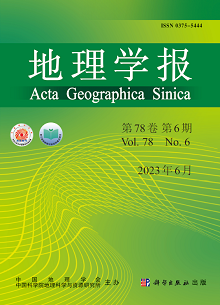
Most of the existing research focuses on local or non-local forces that promote regional development, but few studies explore the "global-local" interactions of import spillovers as external knowledge, leaving the specific mechanism unclear. Based on China's customs data from 2000 to 2016, the import spillover effects on Chinese manufacturing industries can be better investigated. With cognitive proximity as a tool of measurement and classification, import products are sorted into three categories: same products, related products and unrelated products. We found that the import spillover effects of same products and related products can significantly increase the probability of export entry and reveal comparative advantage enhancement in city-product dimension, while the effect of unrelated products remains negative. Furthermore, the mediation effect of urban related production capacity is verified. The import of the same products and related products can improve the urban related production capacity, while the import of unrelated products plays the opposite effect. In addition, the process of import spillover effects promoting the expansion of export products shows significant heterogeneity at the product and regional levels. To give full play to the positive role of import spillover effect and avoid its negative role, local governments should build industrial chains around local core products and optimize import structure and mode. Strengthening the cultivation of local technology R&D and innovation capabilities, and improving the local ability to absorb, transform and utilize external knowledge is also helpful. After meeting the local import demand, the resource competition and crowding out effect caused by the excessive introduction of irrelevant products should also be paid attention to. Finally, differentiated import modes and strategies should be adopted according to the nature of export products, regional industrial base and export development level, so as to create a spatial aggregation form with close technological links for enterprises and industries, enhance cognitive proximity, and promote the flow and dissemination of tacit knowledge.
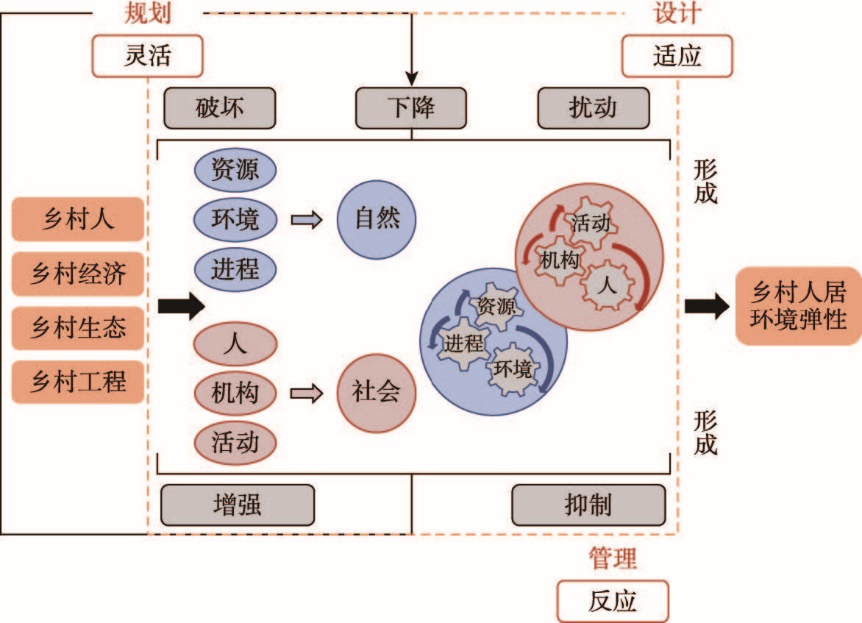
The rural human settlement is an indivisible part of the urban-rural human settlements, and it is also the comprehensive embodiment of the rural man-land relationship. Based on the theoretical framework of the formation of rural human settlement resilience and combined independent weight method and regression analysis, this paper builds an index system of the formation of rural human settlement resilience. This system comprehensively measured the rural human settlements in the Dongting Lake area and analyzes the spatial differentiation characteristics of resilience and its formation mechanism. The results show that: (1) There are evident spatial differences in the degree of resilience formation of rural human settlement in the study area. Resilience value varies based on the distance to the lake areas, the nearer the higher, the further the lower, which demonstrated the spatial differentiation characteristics of "inner high and outer low". (2) Based on the measured results of flexibility, adaptability and responsiveness, the resilience formation level in the Dongting Lake is divided into 3 ring belts in space: Huarong-Linxiang ring belt, Lixian-Pingjiang ring belt and Shimen-Heshan ring belt. (3) Rural human settlement is affected by the combination of exogenous and endogenous factors, which, in the form of mutation, continuation and transformation, have positive and negative effects on the resilience formation, so as to facilitate or not to facilitate the formation of rural human settlement resilience. On the basis of the geographical location, resource endowment, economic and social differences of three ring belts in the Dongting Lake, the corresponding strategies are put forward according to the principle of adapting to local conditions. In the process of optimizing rural human settlement, the monitoring, prediction and anti-disturbance capabilities of rural human settlements are enhanced, the resilience is continuously improved and the sustainable development of rural areas is promoted.
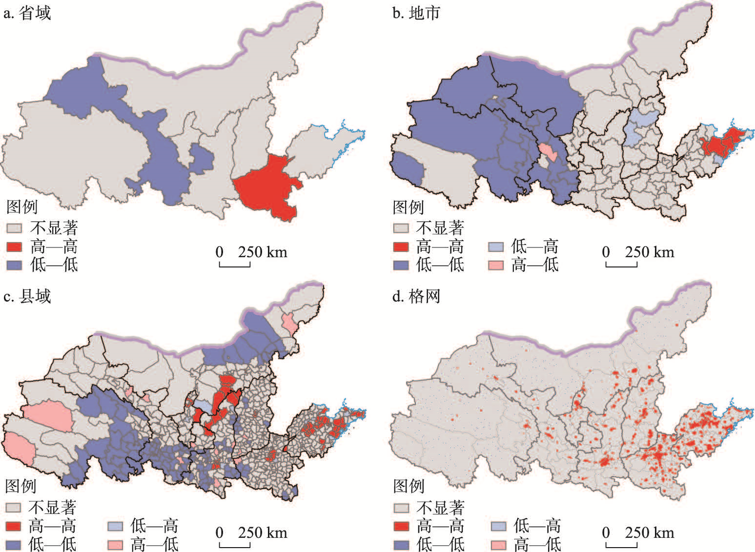
To realize high-quality development in the Yellow River Basin, the study on economic differences should not be confined to the upper, middle and lower reaches of the Yellow River. In addition, possible differences under various scales should be analyzed. The difference between border counties and non-border counties is an important aspect which needs further study. Therefore, nighttime light data were used to describe the economic development level from the core-periphery perspective, and the spatial autocorrelation method was used to identify the differences. Then an index of the difference in economic development was constructed to describe the evolution of core-periphery structure in the economic development from 1992 to 2019. Finally, the regression model was employed to explore how the evolution is driven by factors including natural endowment, location, traffic, industrial structure and government capacity. The results show that: (1) There are obvious economic differences between the upper, middle and lower reaches of the basin. However, with the scale decreases, there are economic differences between provincial capitals and non-provincial capitals, and between provincial border areas and non-border areas, highlighting the core-periphery structure. (2) The core-periphery structure of county economic development in the Yellow River Basin is weakening. In terms of provinces, Shandong's economy is developing well, the periphery and core counties are developing in a balanced way, and the core-periphery structure is weak. The core-periphery structure in Henan, Shanxi and Ningxia is relatively stable. However, the development of border counties and core areas in Shaanxi, Inner Mongolia, Gansu and Qinghai is unbalanced, showing a core-periphery polarization. (3) Natural endowments and location are the basis for the formation and development of core-periphery structure. However, the improvement of transportation, industrial structure and government capacity have a positive effect on narrowing the economic gap and delaying the polarization of the core-periphery structure. Therefore, strengthening the construction of transportation infrastructure, adjusting industrial structure and improving government capacity can help reduce the economic differences in the Yellow River Basin.
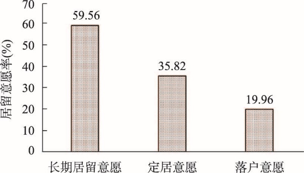
In view of the inherent differences in the willingness of long-term residence, permanent settlement, and hukou conversion, as well as the identification and classification of related indicators, this paper examines the occurrence sequence and urban differences of the migrant population's willingness of long-term residence, permanent settlement and hukou conversion in the residence process based on the questionnaire of the migrant population in 25 cities in China. Through multi-level logit regressions, this paper compares the differences and similarities of the influence mechanisms of different willingness, and the determinants of the willingness to stay. The study finds that: (1) From the perspective of the process, the willingness to stay of the migrant population is sequential and progressive. Generally speaking, the willingness of permanent settlement is generated based on the willingness of long-term residence, and the willingness of hukou conversion occurs based on the willingness of permanent settlement. However, the willingness of hukou conversion in first-tier cities is higher than that of permanent settlement, and the relationship is more complicated. (2) From the perspective of the influence mechanisms, in addition to human capital, the generation of the willingness of long-term residence is mainly affected by social relations and social integration; the willingness of permanent settlement is significantly affected by economic income and family migration, and certain level of economic income and family migration can greatly improve the willingness to settle down permanently; the willingness of hukou conversion is mainly affected by identity and urban factors, and the higher degree of identity in the inflow area, the higher willingness of hukou conversion. (3) From the perspective of urban hierarchy, the willingness of permanent settlement shows an inverted "U"-shaped trend, with the highest willingness to settle down in provincial capital cities and the lowest in first-tier cities such as Beijing; the willingness of hukou conversion increases with the increase in urban hierarchy, and the migrants have higher willingness of hukou conversion in upper-level cities. The former is driven by economic factors, and is the result of the trade-off between the city's attractiveness and the cost of living, while the latter is driven by the degree of recognition, which is higher in upper-level cities. In the process of citizenization, the formation of the willingness to settle down is a key part. It is necessary to implement policies based on characteristics of the city to help improve the economic strength of the migrant population, promote family migration, and weaken the indicative significance of hukou conversion.
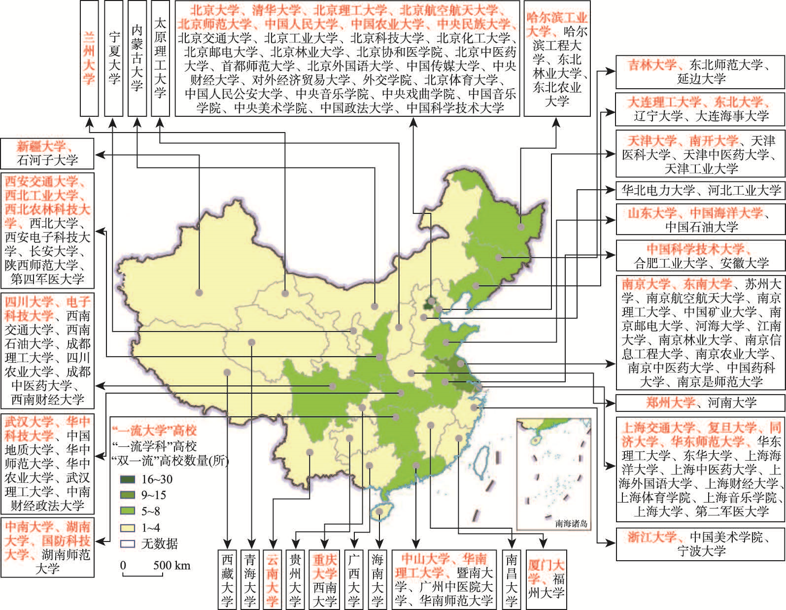
China has entered the stage of transformation from a "demographic dividend" to a "talent dividend", and talent has increasingly become the key driver of national and regional development in the era of a knowledge economy. As the reserve of talents, university graduates are the main target of the "war for talent" among Chinses cities. Based on the 2019 Graduate Employment Quality Reports of China's "double first-class" universities, adopting the Gini coefficient, spatial autocorrelation, and spatial econometric interaction model, this paper demonstrates the migration pattern of "double first-class" university graduates upon their graduation and investigates its underlying influencing factors. The results reveal that the destination areas of university graduates from "first-class universities" and "first-class disciplines" are highly concentrated in eastern China, with the former showing a higher concentration level. While economic factors still play a vital role in determining the migration of university graduates, the influence of quality of place is also significant, especially for graduates from "first-class universities". In addition, the policy factors also significantly influence the migration pattern of graduates from both types of universities. There are significant network autocorrelation effects among graduates' employment migration flows. The network autocorrelation effects based on places of study and places of employment are significantly positive. These network autocorrection effects reinforce the uneven distribution pattern of university graduates' migration. This study highlights the importance of employing a regional coordination perspective rather than a single-region perspective in terms of the formation and further optimization of regional talent policies.
Selecting 887 inter-provincial border counties in China as a research area, this paper constructs an evaluation index system incorporating five dimensions to measure the degree of urbanization that each county experienced from 2000 to 2019, describes characteristics of the evolution of urbanized spatial patterns combined with spatial autocorrelation analysis, uses geodetectors to identify the main factors influencing urbanization and interactive relationships, divides driving areas into types on the above basis, and proposes targeted suggestions. The results show that: (1) From 2000 to 2019, the urbanization level of China's inter-provincial border areas continued to increase, but the overall level remained low, and displayed a spatial distribution pattern of stepwise decline from east to central to west. (2) The urbanization level of counties on the inter-provincial border showed a significant positive spatial correlation. In terms of spatial distribution, HH-clustering counties formed a "T" pattern, and LL-clustering counties concentrated in the inter-provincial border areas of the northwest, northeast, and southwest. (3) Economic development and traffic level are the leading factors affecting the spatial pattern of urbanization in the inter-provincial border areas. (4) The spatial pattern of urbanization in the inter-provincial border areas results from the main factors directly driving economic development and determining transportation levels. In addition, medical care, social investment, and natural conditions also directly impact the spatial pattern of urbanization. Government behavior and educational services exert indirect effects. (5) Inter-provincial border areas are divided into six types with distinct patterns of leading driving factors: terrain element restriction, location traffic leading, economic development driving, social investment driving, public service lagging, and government leading. (6) Urbanization of inter-provincial border areas exerts a spatial nearest neighbor effect, and the urbanization level of counties close to urban agglomerations of developed regions is high. The marginality of urbanization space of counties in the inter-provincial border areas is prominent. In areas with more county borders in the inter-provincial areas, urbanization levels tend to be lower.

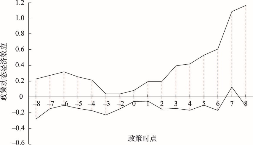
Based on the quasi-natural experiment, this paper uses the method of time double difference (DID) to empirically test the differential impact and mechanism of the opening of China Railway Express on the export trade of cities along the rail line by using the panel data of 279 prefecture-level cities in China from 2004 to 2019. The results show that: (1) The opening of China Railway Express has significantly promoted the export trade growth of cities along the rail line in China. The better the local transportation infrastructure conditions, the stronger the driving effect on the growth of local export trade. Exports are also positively regulated by the number of countries passing through and the logistics transportation capacity of the destination country. (2) Heterogeneity analysis found that the opening of the train has a significant positive impact on the export trade of the node cities of the supply hub, but it has no significant impact on the railway hub cities, and has a certain inhibitory effect on the export of the port cities. From the perspective of city size, the positive promotion effect of trade mainly occurs in small and medium-sized cities. Based on the analysis of different geographical location train channels, it is found that the promotion effect on the export trade growth of cities along the western channel is obvious. (3) The organization and operation of China Railway Express follow the "axle-spoke" mode, and their radiating space to the surrounding areas is roughly within 150 kilometers. The intermediary mechanism test shows that the opening of China Railway Express can promote the growth of export trade by improving the regional marketization level, and the positive intermediary effect of marketization level is more significant for cities in peripheral regions. The intermediary effect of transportation time cost saving is not significant, and the saving of time required by traditional shipping is not the main reason to promote the growth of export trade.
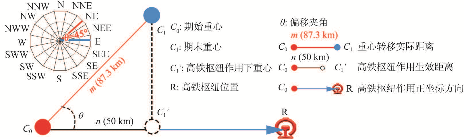
The construction of high-speed railway hub is one of the important elements to guide the spatial expansion of the city. Taking 37 cities with high-speed railway hubs in Yangtze River Economic Belt as examples, this paper constructs a model of high-speed railway hub-driven the city's center of gravity transit index, analyzes the spatial expansion effect of cities driven by high-speed railway hubs, and uses Geodetector to reveal the mechanism of urban spatial expansion driven by high-speed railway hubs. The results of this study showed that: (1) The spatial expansion effect of cities in the Yangtze River Economic Belt driven by high-speed railway hubs is divided into three levels: firstly, the cities' center of gravity is driven to expand significantly to high-speed railway hubs, showing a "targeted" state of expansion; secondly, the cities' center of gravity is driven to expand moderately to high-speed railway hubs, showing a "budding" state of expansion; thirdly, the cities' center of gravity is driven to expand inconspicuously to high-speed railway hubs, showing "no obvious adhesion" state of expansion. (2) The role mechanism of urban spatial expansion driven by high-speed railway hubs is mainly manifested in 4 dimensions and 11 factors, such as city level, the degree of development of high-speed railway hubs, and station-city relationship. Among them, city level plays the role of "driving force", and the factors of "city level" and "rate of change in external accessibility of cities" play a significant role; the degree of development of high-speed railway hub plays the role of "traction", and the factor of "high-speed rail hub grade" plays a significant role; the relationship between station and city plays the role of "catalyst", and the factor of "accessibility of hub" plays a significant role; the degree of government policy plays the role of "guidance".
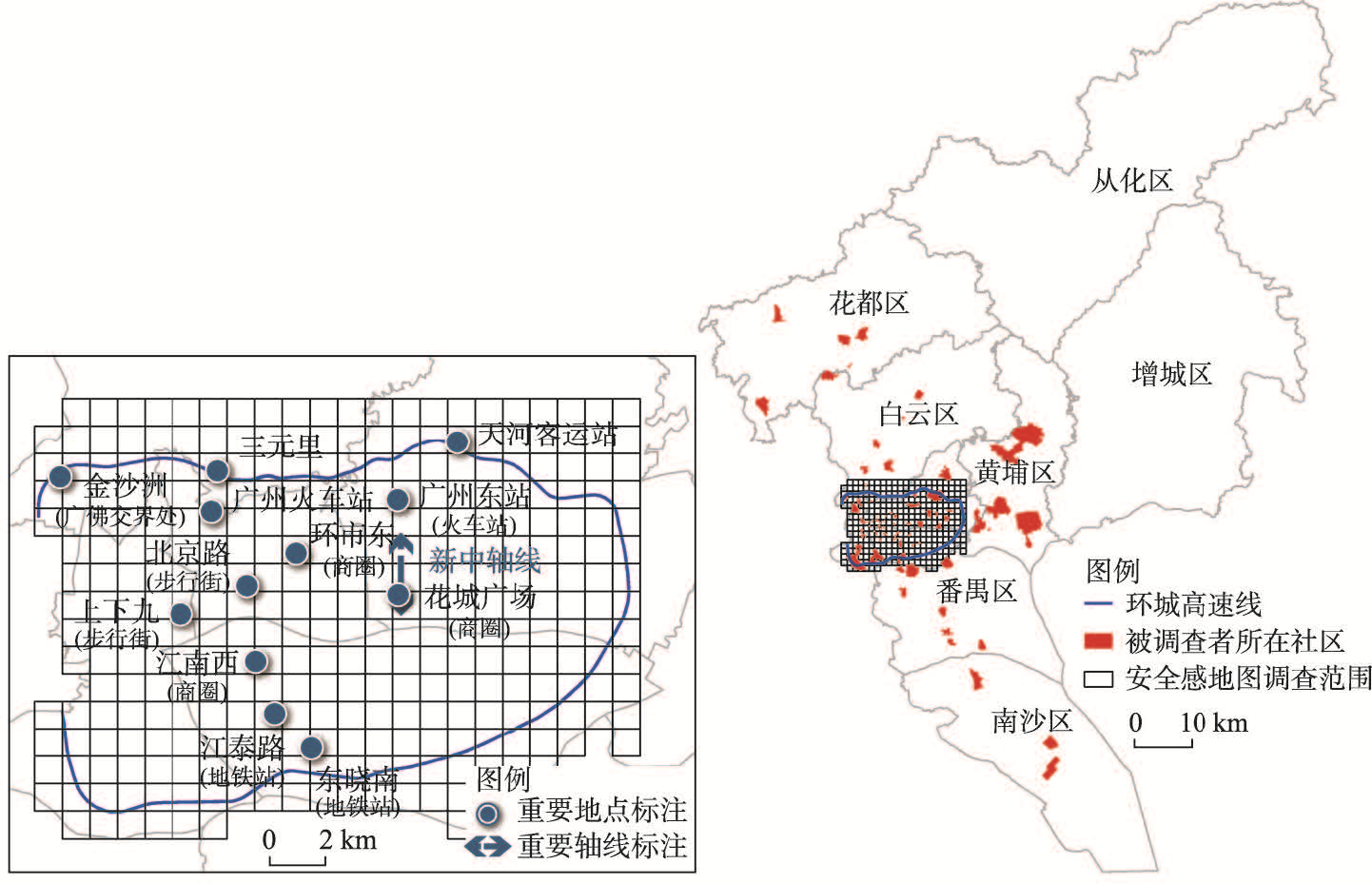
As people's needs shift from the material level to the spiritual level, the safety perception of city is increasingly important to the sound development of society. In the meanwhile, there are group differences in the spatial distribution of safety perception, and understanding these differences and their environmental influences can help to respect and meet diverse needs during the process of urban planning and management. Previous research mainly focused on safety perception of residents in their home area, while few studies have investigated the safety perception of different groups outside their residential area. Besides, how environmental factors affect the group differences of their safety perception maps is unclear. Based on current deficiencies, a survey including 1149 participants was carried out in central area of Guangzhou to collect different safety perception maps of three income groups. Negative binomial regression models were used to test the environmental impact on the spatial distribution of safety perception of different income groups, with the environmental factors selected from three aspects: built environment, socioeconomic environment and environmental disorganization. The results show that: (1) long-distance transport facilities such as railway station and coach station, the junction area of Guangzhou-Foshan, and business districts in old city are all marked as high-risk perception area among three income groups. (2) There are certain differences in the spatial distribution of safety perception of the three income groups, among which the safety perception map of the low-income group is significantly different compared to two other groups. (3) Environmental factors such as the distribution of important transport facilities, blue space, land use diversity and intersection density have significant influence on the safety perception map of all income groups. (4) Density factors such as density of entertainment facilities and commercial buildings have a greater impact on the sense of safety of low- and medium-income groups. Design factors like sky openness and green space proportion have more impact on the median- and high-income groups. The impact of socioeconomic level and environmental disorganization factors (e.g., density of police station and instability of passenger flow) present great differences among three income groups. The study can provide theoretical reference for the construction of urban safety environment, establishment of safety image, as well as for humanistic and detailed urban planning and management in the future.
The planning and construction of urban 15-minute life circle is a key tool for equally allocating urban public resources and promoting sustainable development. However, it is challenging to design the public service systems toward urban living circle: how many service facilities are required, where to locate the facilities, and how to promote service equality for urban residents. A new facility location problem was proposed for public facility planning toward urban living circle. The new problem, μ CFLP, is a variant of classical capacitated facility location problem (CFLP) with constraints of maximum service radius and partial demand covering. A mixed integer linear programming model was formulated for the μCFLP and a matheustic algorithm was designed for solving this model. The model and the solution method were tested on 6 study areas. According to the Chinese city scale classification standard, 6 typical urban regions in China were selected. Then, the community health service center was taken as a service example to conduct the service facility layout planning experiment. The results show that: (1) the new model can balance the service quality, efficiency and fairness, and thus can be applied to the layout planning of public service facilities toward urban living circle. (2) In cities with low population density, the model is sensitive to the two planning parameters: service radius and coverage; and thus it is necessary to balance service quality and efficiency. While in the metropolis with high population density, it is relatively easy to meet the construction standard of 15-minute life circle. The experimental results show that the model proposed in this study has obvious advantages for the planning of urban service facilities toward the 15-minute life circle goal. First, the number of facilities need not be determined in advance. Second, the optimal layout of facilities can be explored according to the combination of coverage radius and coverage parameters.
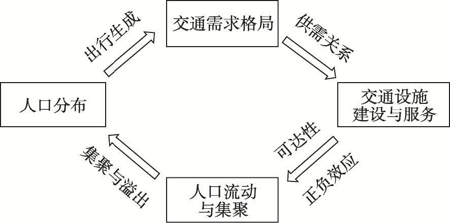
Population's size, structure and distribution and related changes are elemental factors determining passenger travel demand. Population is a pre-condition for efficiently planning, building, operating and managing transportation infrastructure facilities. China's population development has witnessed new trends in China in recent years. This has brought new requirements for the people-centered strategies of transportation system. It is imperative for researchers to explore the people-centered land passenger transportation regionalization in order to support policy-making of transportation infrastructure and service supply. By using the theory of geographical regionalization, this study identifies, for the first time, China's land passenger transportation regionalization under the people-oriented strategies. Population's mobility, spatial agglomeration, production activities and livelihood needs are included as major factors in transportation regionalization. The status quo of transportation facilities are also considered. Multi-source big data and actor-weighted superposition and spatial clustering methods are applied. Five first-level zones and four second-level zones are identified. First-level zones include East-Central transportation area I (prioritizing integration and quality improvement), Northeast transportation area II (prioritizing optimization and refinement), West-middle-south transportation area III (prioritizing accelerated development), Northwest transportation area IV (prioritizing stabilization and enhancement), and Qinghai-Tibet transportation area V (prioritizing basic security). Second-level zones include scattered point type, axial belt type, radial type, and network type. The results of people-oriented land passenger transportation regionalization in this paper would improve the theory of transportation geography, and enrich the application of geography in China's national transportation strategy.
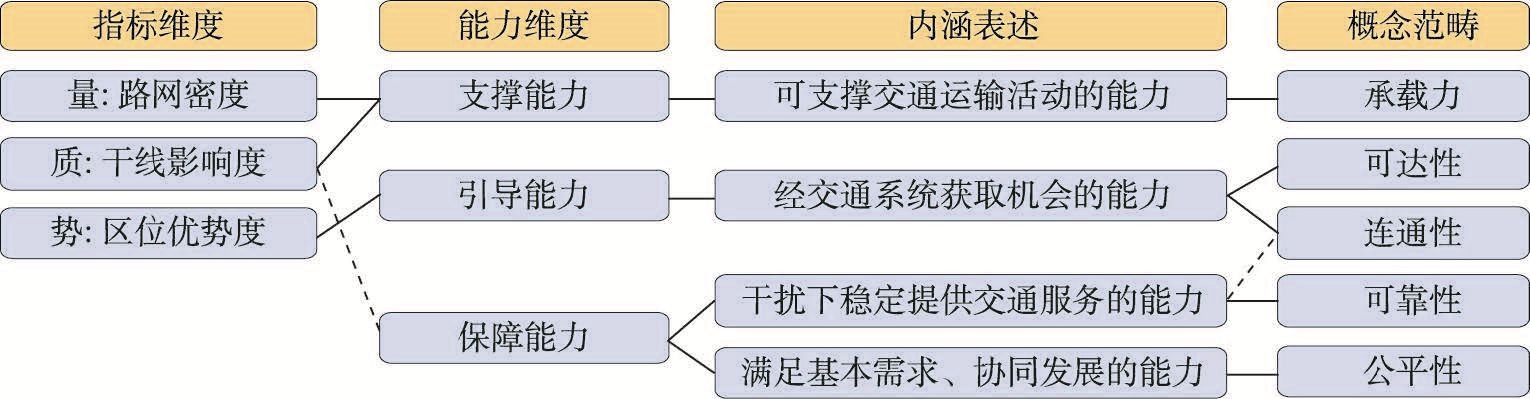
The transport superiority degree is an important and widely used indicator to evaluate the superiority of regional transport infrastructure. It also serves as a primary indicator for the main functional area planning. It has been extensively utilized since its establishment. However, existing literature has rarely discussed and developed the evaluation dimension by integrating regional characteristics based on the connotation discussion. The purpose of this article is to return to the "support, guidance and guarantee" capacity of transport in regional development that is originally emphasized by the transport superiority. This article elaborates and expands the connotation of support and guidance capacity from the perspectives of bearing capacity, accessibility and connectivity. Besides, the concepts of reliability and equity are introduced into the guarantee dimension, thereby enriching the conceptual and analytical framework of transport superiority degree based on the three capacity dimensions. On this basis, this article takes Tibet as a case area and its pertinent counties as the basic evaluation units. Specifically, according to the regional and transport characteristics of Tibet, this article introduces indicators such as average connectivity of roads and seasonal fluctuation into the guarantee dimension, and employs finer and multi-modal accessibility indexes to better evaluate the guidance capacity. The obtained results reveal that: (1) There are obvious discrepancies in the transport superiority degree between counties in Tibet, with high transport superiority degree in Lhasa, Nyingchi, and Shigatse, and generally presenting the characteristics of point-axis pattern along the river valley, while all prefecture-level regions exhibit the core-periphery structure around the districts and counties of prefecture-level administrative centers. It should also be noticed that there exist a large number of districts and counties with low transport superiority degrees in Tibet. (2) Compared with the traditional form of transport superiority degree, the improved transport superiority degree evaluation can apparently show the pattern of the three capacity dimensions of Tibet's transportation condition. It can also reveal the disadvantages of transport guarantee capacity of counties in Qiangtang plateau, western Tibet, and the border of southeast Tibet, as well as the wide range of transport disadvantaged areas they formed. In the near future, the opening of the Sichuan-Tibet Railway will remarkably enhance the transport superiority of eastern counties in Tibet, but it is still difficult to restore the disadvantage of border counties in Ngari. (3) The discussion of the three capacity dimensions in the present study offers a potential conceptual framework for developing the transport superiority degree. This framework also involves some controversial cutting-edge issues. After further development, it is beneficial for more precisely assessing the advantages and disadvantages of regional transportation and carrying out transportation planning in the new era.
Rural tourism destinations are becoming places where stakeholders encounter dialogue and conflict amid a multifunctional transformation underway in rural areas. The land-use conflict has increasingly become a prominent issue since stakeholders have different demands. This paper constructs a conflict-coordination theoretical research framework and internal correlation mechanism concerning stakeholders' cognition of multifunctional spaces in rural tourism destinations. Taking Shancha Village as the case study, the paper identifies the potential points of conflict utilizing density mapping and different models for responding to conflict situations. The coordination among different multifunctional demands was analyzed based on the Grounded Theory and the DEMATEL method. The findings are as follows. First, rural residential areas perform agricultural and living functions. The village's five major scenic spots have economic, travel and leisure functions, while the whole village plays an ecological role and function. The agriculture of this village is restricted within a certain radius. Place-based transportation and an industrial layout around the scenic area are characteristics. Furthermore, there is an overlap in production-living-ecological spatial cognition. Second, the distribution of high values areas in the Overall Preference Difference (OPD) shows that the agricultural function distribution depends on agricultural production conditions and the population density of settlements. As for economic function, the economic spillover effect of scenic spot development is differentiated at different levels of development. Moreover, transportation in residential areas influences the distribution of the living function. Spatially, the ecological function is mainly distributed in the Huangshan Scenic Area, and tourism resources constrain the distribution of travel and leisure functions. Third, regarding conflict points, agricultural function conflicts are concentrated on arable land and garden plots due to differences in the awareness of production layout, facilities and economic benefits in mountainous areas. Economic functions are concentrated on land for commercial services, whether or not for tourism purposes, caused by differences in cognition of industrial land management, construction land scarcity and tourism revenue and dividends. Furthermore, the difference in awareness of infrastructure allocation, quality of living conditions and commodification of rural spaces leads to the distribution of living functions in rural homesteads, regions equipped with service facilities and water regions. Moreover, due to the gap in the cognition of environmental regulation, ecological conservation and ecological benefits, ecological functions are concentrated in water, woodlands and some agricultural land. In addition, ravel and leisure functions are distributed in scenic spots and tourist roads due to differences in the cognition of development methods, transportation accessibility and tourism revenue. Fourth, in terms of coordination between multifunctional demands, living functions are witnessing overall coordinated development. Residents' interests, agricultural production and sales, and the demands of enterprises for dividends and a better ecological environment are the leading factors affecting the coordinated development of agricultural, economic and ecological functions. Demand by government and enterprises for a tourism market and residents' need for tourism revenue have become the dominant factors that affect travel and leisure functions. Hence, the conflict-coordination mechanism and path of multifunctional spatial cognitive conflict are constructed, satisfying stakeholders' demands as a starting point.

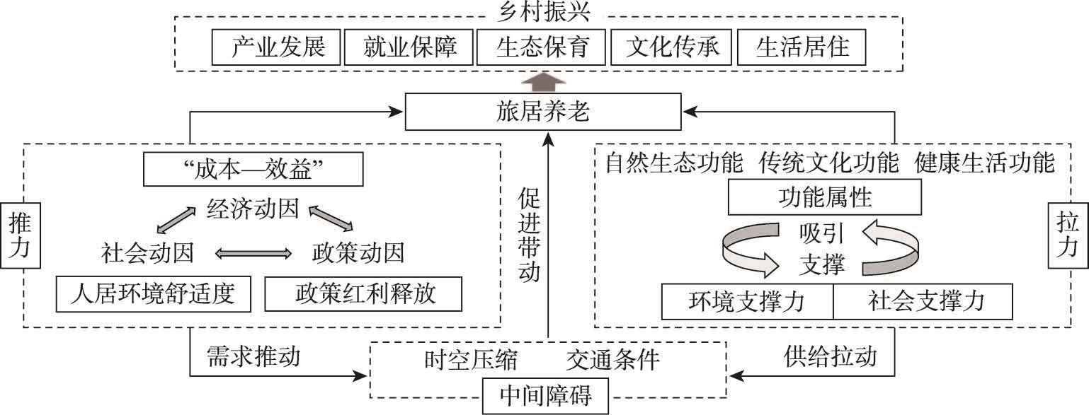
Senior residential tourism is the product of upgrading demand for elderly care, and thus effectively fits the national development strategy of rural revitalization. Based on grasping the connotation of senior residential tourism, the paper constructs a framework to analyze the development of senior residential tourism with the push-pull theory. This paper uses various analytical methods to discuss senior rural residential tourism's spatial and temporal evolution pattern and formation mechanism, and further reveals and analyzes the typical development mode. The findings are as follows: (1) Senior residential tourism is a lifestyle in which the elderly live continuously in the sojourning place for the dual purpose of deep experience and living. To grasp its connotation, it is necessary to clarify the key issues, such as the subject of action, the motive of action, the time limit, and the moving distance. (2) In terms of temporal dimension, China's senior rural residential tourism has experienced three stages, namely, the budding stage, the slow development stage, and the high-speed development stage, which show a trend of structure type optimization, increased participation of social capital, and market development segmentation. (3) In terms of spatial dimension, senior rural residential tourism development strongly correlates with the "Hu Huanyong Line." During the study period, the high-density core area evolved from the "single-level core" of the Yangtze River Delta to the "three-pillar" situation of the Yangtze River Delta, Beijing-Tianjin-Hebei region, and Pearl River Delta. (4) Under the framework of "push, pull, and intermediate barrier", the development of China takes the pulling force as the dominant driving force, which mainly includes the number of intangible cultural heritages, the number of tourist resorts, and other factors. (5) Finally, based on the comprehensive analysis of regional development factors, this paper classifies senior rural residential tourism into four typical development modes: natural support, cultural tourism support, health support, and mixed type, and thus puts forward a development path according to local conditions and classification.
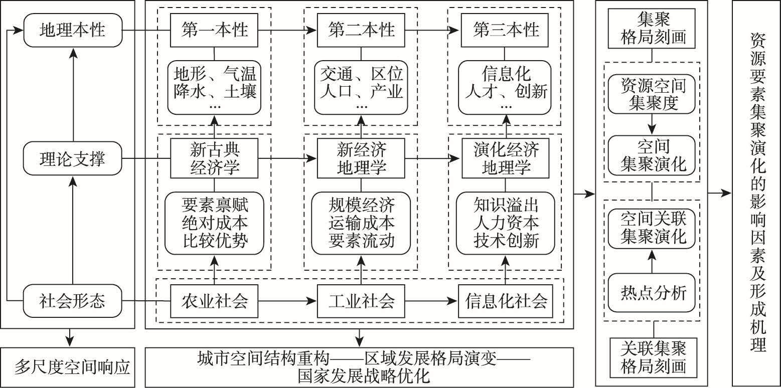
It is of great significance to explore the new expression of emerging resource elements in geographical space for formulating and optimizing national development strategies. This paper constructs a theoretical framework of resource agglomeration and evolution from the perspective of geographical nature, and studies the pattern evolution and formation mechanism of commercial fitness resources agglomeration in China by using the methods of spatial analysis and factor detection. The results are as follows: (1) The spatial agglomeration pattern shows two remarkable characteristics. First, the spatial pattern and evolution trend exhibit the "cross-shaped" corridor with the Beijing-Guangzhou Railway and the golden waterway of the Yangtze River as the backbone. The regional central cities play an important role in this pattern. Second, the urban agglomerations are the main areas for the spatial distribution of commercial fitness resources, with those in the coastal areas playing a leading role. (2) The pattern of cold and hot spots of China's commercial fitness resources presents a remarkable ladder-like distribution feature, and the hot spots and sub-hot spots gradually evolved into sub-cold spots and cold spots from east to west. The spatial hot spots have experienced the process of expanding from the Bohai Rim and the Yangtze River Delta to north China, central China and east China. The sub-hot spots in the northeast and northwest regions have a tendency to cross the Hu Huanyong Line and expand westward. The overall change of the sub-cold spot and the cold spot areas is relatively stable, and the local changes are mainly manifested in the evolution of the cold spot area into the sub-cold spot area in the east of Guangxi and the west of Guangdong. (3) The agglomeration and evolution of commercial fitness resources in China are the result of the interaction and coupling of three geographical natures. Different factors play different roles in the formation of the spatial agglomeration of commercial fitness resources. The first, second and third geographical natures play a basic control role, a material support role and a leading role in the agglomeration and evolution of commercial fitness resources, respectively.