植被与碳循环

非洲大陆区域一体化背景下国家边境森林变化及其主要因素贡献

  • 唐梦雅 , 1 ,
  • 李鹏 , 2, 3 ,
  • 李霞 1 ,
  • 陈生媚 4 ,
  • Jeffrey Chiwuikem CHIAKA 5, 6
展开
  • 1.长安大学土地工程学院,西安 710054
  • 2.中国科学院地理科学与资源研究所,北京 100101
  • 3.中国科学院大学资源与环境学院,北京 100049
  • 4.长江大学地球科学学院,武汉 430100
  • 5.北京师范大学环境学院环境模拟与污染控制国家重点联合实验室,北京 100875
  • 6.Anambra-Imo 河流域发展局,尼日利亚 奥韦里 1301
李鹏(1984-), 男, 江西永新人, 博士, 研究员, 博士生导师, 研究方向为资源遥感与边境地理。E-mail:

唐梦雅(2000-), 女, 新疆巴州人, 硕士生, 研究方向为边境土地利用变化。E-mail:

收稿日期: 2024-06-24

  修回日期: 2025-01-08

  网络出版日期: 2025-05-23

基金资助

国家自然科学基金项目(42371282)

国家自然科学基金项目(42130508)

Forest change and the contributions of major influencing factors along international borders in the context of regional integration of African continent

  • TANG Mengya , 1 ,
  • LI Peng , 2, 3 ,
  • LI Xia 1 ,
  • CHEN Shengmei 4 ,
  • Jeffrey Chiwuikem CHIAKA 5, 6
Expand
  • 1. School of Land Engineering, Chang'an University, Xi'an 710054, China
  • 2. Institute of Geographic Sciences and Natural Resources Research, CAS, Beijing 100101, China
  • 3. College of Resources and Environment, University of Chinese Academy of Sciences, Beijing 100049, China
  • 4. School of Geosciences, Yangtze University, Wuhan 430100, China
  • 5. State Key Joint Laboratory of Environmental Simulation and Pollution Control, School of Environment, Beijing Normal University, Beijing 100875, China
  • 6. Anambra-Imo River Basin Development Authority, Owerri 1301, Nigeria

Received date: 2024-06-24

  Revised date: 2025-01-08

  Online published: 2025-05-23

Supported by

National Natural Science Foundation of China(42371282)

National Natural Science Foundation of China(42130508)

摘要

经济全球化与区域一体化促使边境从封闭走向开放并渐成人地关系研究热点区域。自《非洲大陆自由贸易区协定》签署以来,非洲一体化进程历经数十载并影响各国边境景观与土地利用。但非洲大陆国家边境森林等土地覆被变化过程尚缺乏深究且对其主要影响因素及其对森林变化贡献量化不足。利用2017—2022年土地覆被产品、活跃火、人口密度与武装冲突数据,在揭示非洲大陆国家边境森林等土地覆被变化年际动态基础上,采用随机森林回归与相关性分析界定森林变化影响因素并量化其主因与贡献。结果表明:① 非洲大陆国家边境以赤道为界向北、向南呈现森林—草灌—裸地递次分布格局,占地近九成,且森林、草灌、裸地三者主导着(> 80%)边境土地覆被变化(年均变化2%);2020年森林有所恢复,但草灌/裸地增加所致毁林仍是大势。② 活跃火和人口密度是非洲边境森林覆被变化主/从因,且森林变化与活跃火频次、人口密度关系先弱后强。③ 非洲大陆国家边境年际近九成森林减少与活跃火发生呈强正相关性,受季节影响由赤道向南北两侧递增。④ 旱季活跃火对非洲大陆国家边境森林减少影响更为显著。本文可为探索热带森林变化诱因和揭示边境土地利用变化对区域一体化响应程度提供借鉴。

本文引用格式

唐梦雅 , 李鹏 , 李霞 , 陈生媚 , Jeffrey Chiwuikem CHIAKA . 非洲大陆区域一体化背景下国家边境森林变化及其主要因素贡献[J]. 地理学报, 2025 , 80(5) : 1226 -1243 . DOI: 10.11821/dlxb202505005

Abstract

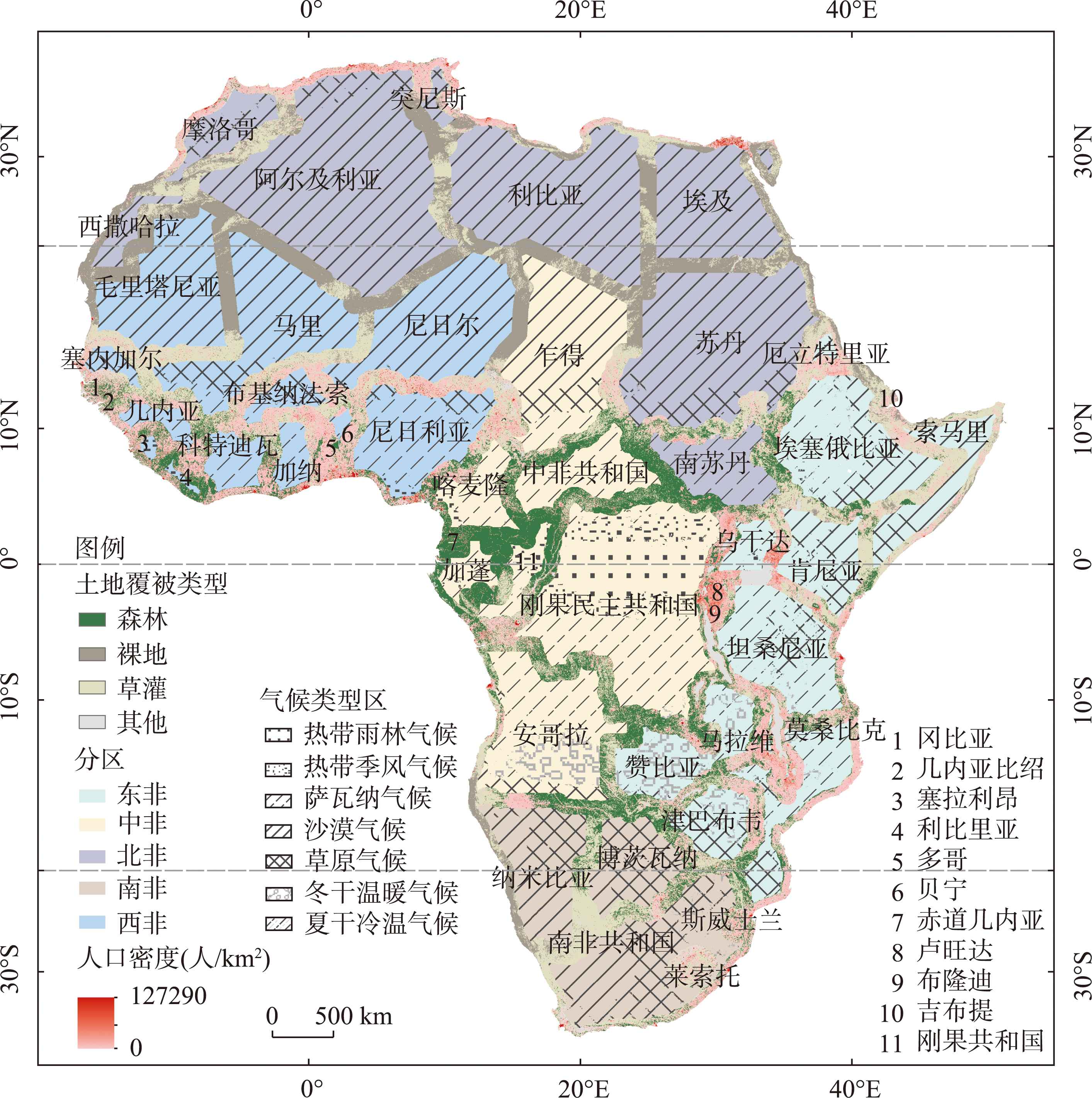
Economic globalization and regional integration have pushed international borders from closure to opening-up, making them a hot spot for studying human-environment relations. The promotion of African integration has lasted for decades and has also affected cross-border landscape and land use. Since the signing of the African Continental Free Trade Area Agreement, the processes of forest loss and gain and other land cover change within international borders of continental Africa and its main influencing factors (e.g., active fire) as well as their contribution remain understudied. With the Sentinel-2 10-m land use/land cover products, Suomi National Polar-orbiting Partnership Visible Infrared Imaging Radiometer Suite (VIIRS) active fires, LandScan population density, and armed conflict records during 2017-2022, we first examined the inter-annual dynamics and cross-transformations between forest (trees), rangeland (grass and shrub), and bare ground within a total of 146 international borders of the African continent, covering 49 countries. We then determined the major influencing factors and quantified their contribution using Random Forest Regression and correlation analysis. The results show that: (1) the international borders of continental Africa are characterized by a general distribution pattern of forest, rangeland, and bare ground in a sequential order in both the northern and southern parts, divided by the equator. The three land cover types account for nearly 90% of all borders, and dominate (>80%) the change in land cover at the borders with an average annual rate of 2%. Forest loss due to the transformation into rangeland remains a major trend albeit short-term forest gain in 2020. (2) Active fire and population density are the primary and secondary respectively causes of forest cover change along national borders in Africa. The relationship between forest changes and the frequency of active fire or population density is initially weak and then strong during the study period. (3) Nearly 90% of interannual forest loss is strongly and positively correlated with the occurrence of active fires along the international borders of continental Africa, showing a gradual increase on both the northern and southern sides of the equator due to the seasonal dynamics of active fires. (4) Active fires have a more pronounced impact on forest decline within African borders during dry seasons. This study contributes to providing a methodological reference for exploring the causal factors of tropical forest change and the extent to which land-use change at the borders responds to regional integration.

[1]
Li P, Xiao Z. Impervious surface expansion in the China-Laos border area under the context of geo-economic cooperation: A case study of the Mohan-Boten Economic Cooperation Zone. GIScience & Remote Sensing, 2022, 59(1): 2184-2201.

[2]
Schon J, Koren O. Introducing AfroGrid, a unified framework for environmental conflict research in Africa. Scientific Data, 2022, 9(1): 116. DOI: 10.1038/s41597-022-01198-5.

PMID

[3]
Nolte K, Sipangule K, Wendt N. Agricultural households in times of crisis. The COVID-19 pandemic, livelihoods and land-use decisions. Journal of Land Use Science, 2022, 17(1): 134-160.

[4]
Zhu A X, Lu G N, Liu J, et al. Spatial prediction based on Third Law of Geography. Annals of GIS, 2018, 24(4): 225-240.

[5]
Li Peng, Qi Yueji, Feng Zhiming, et al. Dynamic characteristics of agricultural expansion and forest loss in the Cambodia-Laos-Vietnam Development Triangle Area under the context of geo-cooperation. Resources Science, 2021, 43(12): 2416-2427.

DOI

[李鹏, 祁月基, 封志明, 等. 地缘合作背景下柬老越发展三角区农进林退动态特征. 资源科学, 2021, 43(12): 2416-2427.]

DOI

[6]
Xiao C W, Li P, Feng Z M, et al. Global border watch: From land use change to joint action. International Journal of Applied Earth Observation and Geoinformation, 2021, 103(10): 102494. DOI: 10.1016/j.jag.2021.102494.

[7]
Bohn T J, Vivoni E R, Mascaro G, et al. Land and water use changes in the US-Mexico border region, 1992-2011. Environmental Research Letters, 2018, 13(11): 114005. DOI: 10.1088/1748-9326/aae53e.

[8]
de la Vega-Leinert A C, Huber C. The down side of cross-border integration: The case of deforestation in the Brazilian Mato Grosso and Bolivian Santa Cruz Lowlands. Environment: Science and Policy for Sustainable Development, 2019, 61(2): 31-44.

[9]
Kuemmerle T, Radeloff V C, Perzanowski K, et al. Cross-border comparison of land cover and landscape pattern in Eastern Europe using a hybrid classification technique. Remote Sensing of Environment, 2006, 103(4): 449-464.

[10]
Metherall N, De Fretes D R, Mandibondibo F, et al. Assessing the development impact of the sota border post connecting Indonesia and Papua New Guinea. Papua Journal of Diplomacy and International Relations, 2022, 2(2): 95-122.

[11]
Zhuo Y Y, Wang M Y, Liu Z J, et al. Border fences reduce potential for transboundary migration of Marco Polo Sheep (Ovis ammon polii) in the Pamir Plateau. Science of The Total Environment, 2024, 912(7): 169298. DOI: 10.1016/j.scitotenv.2023.169298.

[12]
Obeng-Odoom F. The African continental free trade area. American Journal of Economics and Sociology, 2020, 79(1): 167-197.

[13]
Musara M, Maredza A. Intra-Africa immigrant entrepreneurship for intra-African trade and economic development: Towards a borderless Africa. Ekonomski Vjesnik, 2022, 35(2): 367-381.

[14]
Jebiwott A, Ogendi G M, Agbeja B O, et al. Mapping the trends of forest cover change and associated drivers in Mau Forest, Kenya. Remote Sensing Applications: Society and Environment, 2021, 23(3): 100586. DOI: 10.1016/j.rsase.2021.100586.

[15]
Hoppe-Speer S, Adams J B, Bailey D. Present state of mangrove forests along the Eastern Cape coast, South Africa. Wetlands Ecology and Management, 2015, 23(3): 371-383.

[16]
Wei X X, Liu Y, Qi L, et al. Monitoring forest dynamics in Africa during 2000-2020 using a remotely sensed fractional tree cover dataset. International Journal of Digital Earth, 2023, 16(1): 2212-2232.

[17]
Gondwe M, Chirwa P, Cho M A, et al. Key drivers of LULCC in co-managed and government-managed forest reserves in Malawi (1999-2018). International Forestry Review, 2022, 24(1): 1-14.

[18]
Leroux L, Bégué A, Lo Seen D, et al. Driving forces of recent vegetation changes in the Sahel: Lessons learned from regional and local level analyses. Remote Sensing of Environment, 2017, 191(4): 38-54.

[19]
Wang S K, He S L, Wang J L, et al. Analysis of land use/cover changes and driving forces in a typical subtropical region of South Africa. Remote Sensing, 2023, 15(19): 4823. DOI: 10.3390/rs15194823.

[20]
Phiri D, Morgenroth J, Xu C. Long-term land cover change in Zambia: An assessment of driving factors. Science of the Total Environment, 2019, 697(52): 134206. DOI: 10.1016/j.scitotenv.2019.134206.

[21]
Sayedi S S, Abbott B W, Vanniere B, et al. Assessing changes in global fire regimes. Fire Ecology, 2024, 20(1): 18. DOI: 10.1186/s42408-023-00237-9.

[22]
Wan C Y, Roy S S. Geospatial characteristics of fire occurrences in southern hemispheric Africa and Madagascar during 2001-2020. Journal of Forestry Research, 2023, 34(2): 553-563.

[23]
FAO. Global Forest Resources Assessment 2020: Main report. Rome, 2020. DOI: 10.4060/ca9825en.

[24]
Kuuwill A, Kimengsi J N, Campion B B. Pandemic-induced shocks and shifts in forest-based livelihood strategies: Learning from COVID-19 in the Bia West District of Ghana. Environmental Research Letters, 2022, 17(6): 64033. DOI:10.1088/1748-9326/ac70ed.

[25]
Bax V, Francesconi W. Environmental predictors of forest change: An analysis of natural predisposition to deforestation in the tropical Andes region, Peru. Applied Geography, 2018, 91(2): 99-110.

[26]
Sinumvayo J P, Munezero P C, Tope A T, et al. Vaccination and vaccine-preventable diseases in Africa. Scientific African, 2024, 24(2): e02199. DOI: 10.1016/j.sciaf.2024.e02199.

[27]
Hargreaves J D. African boundaries: A legal and diplomatic encyclopaedia. African Affairs, 1979, 78(313): 565-566.

[28]
Flesch A D, Epps C W, Cain J W, et al. Potential effects of the United States-Mexico border fence on wildlife. Conservation Biology, 2010, 24(1): 171-181.

DOI PMID

[29]
Illés I. Borders and cross-border co-operation in the countries of central and south-eastern Europe. Comparative Southeast European Studies, 2002, 51(4-6): 289-302.

[30]
Beck H E, Zimmermann N E, McVicar T R, et al. Present and future Köppen-Geiger climate classification maps at 1-km resolution. Scientific Data, 2018, 5(1): 180214. DOI: 10.1038/sdata.2018.214.

[31]
Karra K, Kontgis C, Statman-Weil Z, et al. Global land use/land cover with Sentinel 2 and deep learning. 2021 IEEE International Geoscience and Remote Sensing Symposium (IGARSS), 2021: 4704-4707.

[32]
Chen Shengmei, Li Peng, Feng Zhiming, et al. Forest disturbance process caused by the expansion of agricultural and construction lands in the border zones of Mainland Southeast Asian countries and their neighbors. Progress in Geography, 2024, 43(4): 741-754.

DOI

[陈生媚, 李鹏, 封志明, 等. 中南半岛及其毗邻国家边境农用地/建设用地扩张所致森林扰动过程. 地理科学进展, 2024, 43(4): 741-754.]

DOI

[33]
Schroeder W, Oliva P, Giglio L, et al. The new VIIRS 375m active fire detection data product: Algorithm description and initial assessment. Remote Sensing of Environment, 2014, 143(4): 85-96.

[34]
Li Peng, Liu Ying, Shi Dong, et al. Comparison of the consistency and discrepancy of three remotely-sensed active fire products (MODIS C6, VIIRS V1 and VIIRS J1). Geographical Research, 2022, 41(5): 1481-1495.

[李鹏, 刘颖, 施冬, 等. 三种活跃火遥感产品(MODIS C6、VIIRS V1和VIIRS J1)一致性与差异性对比. 地理研究, 2022, 41(5): 1481-1495.]

DOI

[35]
Xu H, Lian X, Slette I J, et al. Rising ecosystem water demand exacerbates the lengthening of tropical dry seasons. Nature Communications, 2022, 13(1): 4093. DOI: 10.1038/s41467-022-31826-y.

[36]
Bright E A, Coleman P R, Dobson J E. LandScan: A global population database for estimating populations at risk. Photogrammetric Engineering and Remote Sensing, 2000, 66(7): 849-858.

[37]
Davies S, Pettersson T, Öberg M. Organized violence 1989-2022, and the return of conflict between states. Journal of Peace Research, 2023, 60(4): 691-708.

[38]
Breiman L. Random forests. Machine Learning, 2001, 45(1): 5-32.

[39]
Fang Kuangnan, Wu Jianbin, Zhu Jianping, et al. A review of technologies on random forests. Statistics and Information Forum, 2011, 26(3): 32-38.

[方匡南, 吴见彬, 朱建平, 等. 随机森林方法研究综述. 统计与信息论坛, 2011, 26(3): 32-38.]

[40]
Du Shukun, Zhang Jing, Han Zhijun, et al. Armed conflict risk prediction and influencing factors analysis based on the random forest model at the grid-month scale: A case study of Indochina Peninsula. Journal of Geo-Information Science, 2023, 25(10): 2026-2038.

[杜树坤, 张晶, 韩志军, 等. 基于随机森林模型的“网格—月”尺度武装冲突风险预测及影响因素分析: 以中南半岛为例. 地球信息科学学报, 2023, 25(10): 2026-2038.]

DOI

[41]
Pearson K. Notes on the history of correlation. Biometrika, 1920, 13(1): 25. DOI: 10.1093/biomet/13.1.25.

[42]
Malahayati M, Masui T, Anggraeni L. An assessment of the short-term impact of COVID-19 on economics and the environment: A case study of Indonesia. EconomiA, 2021, 22(3): 291-313.

[43]
Li Peng, Jin Xianghao, Li Xia. How do tropical active firesrespond to intra-annual climate change in the early 21st century? Geography andSustainability, 2025, 6(3): 100253. DOI: 10.1016/j.geosus.2024.100253.

[44]
van Wees D, van der Werf G R, Randerson J T, et al. The role of fire in global forest loss dynamics. Global Change Biology, 2021, 27(11): 2377-2391.

DOI PMID

[45]
Goffner D, Sinare H, Gordon L J. The Great Green Wall for the Sahara and the Sahel Initiative as an opportunity to enhance resilience in Sahelian landscapes and livelihoods. Regional Environmental Change, 2019, 19(5): 1417-1428.

[46]
Biaou S, Gouwakinnou G N, Biaou H S S, et al. Identifying the land use and land cover change drivers: Methods and case studies of two forest reserves in Northern Benin. Environment, Development and Sustainability, 2022, 24(8): 9885-9905.

[47]
Liu Ying, Li Peng, Xiao Chiwei, et al. Spatial characteristics and national differences of active fires derived from Visible Infrared Imaging RadiometerSuite (VllRS) in Mainland Southeast Asia in the dry season during 2012-2019. Progress in Geography, 2021, 40(8): 1406-1418.

DOI

[刘颖, 李鹏, 肖池伟, 等. 中南半岛旱季VIIRS活跃火的空间特征与国别差异. 地理科学进展, 2021, 40(8): 1406-1418.]

DOI

[48]
Miettinen J, Stibig H J, Achard F. Remote sensing of forest degradation in Southeast Asia: Aiming for a regional view through 5-30 m satellite data. Global Ecology and Conservation, 2014, 2(2): 24-36.

[49]
Li Xia, Jin Xianghao, Li Peng. Land conversion between agriculture and forestry and its contributing role of active fires in Mainland Southeast Asia over the past two decades. Transactions of the Chinese Society of Agricultural Engineering, 2024, 40(24): 256-265.

[李霞, 金相皓, 李鹏. 中南半岛近20年农林转换及其活跃火贡献. 农业工程学报, 2024, 40(24): 256-265.]

[50]
Hu Tao, Peng Jian, Dong Jianquan, et al. Forest definitions collaboration based on global remote sensing data products. Acta Geographica Sinica, 2024, 79(5): 1115-1128.

DOI

[胡涛, 彭建, 董建权, 等. 基于全球遥感产品的森林概念协同. 地理学报, 2024, 79(5): 1115-1128.]

DOI

文章导航

/