
长江三角洲空间结构演化规律与理论模型
|
陆玉麒(1963-), 男, 江苏张家港人, 教授, 博士生导师, 主要从事空间结构与区域发展研究。E-mail: luyuqi@263.net |
收稿日期: 2024-06-26
修回日期: 2024-11-25
网络出版日期: 2024-12-27
基金资助
国家自然科学基金项目(42171171)
Evolutionary patterns and theoretical models of spatial structure in Yangtze River Delta
Received date: 2024-06-26
Revised date: 2024-11-25
Online published: 2024-12-27
Supported by
National Natural Science Foundation of China(42171171)
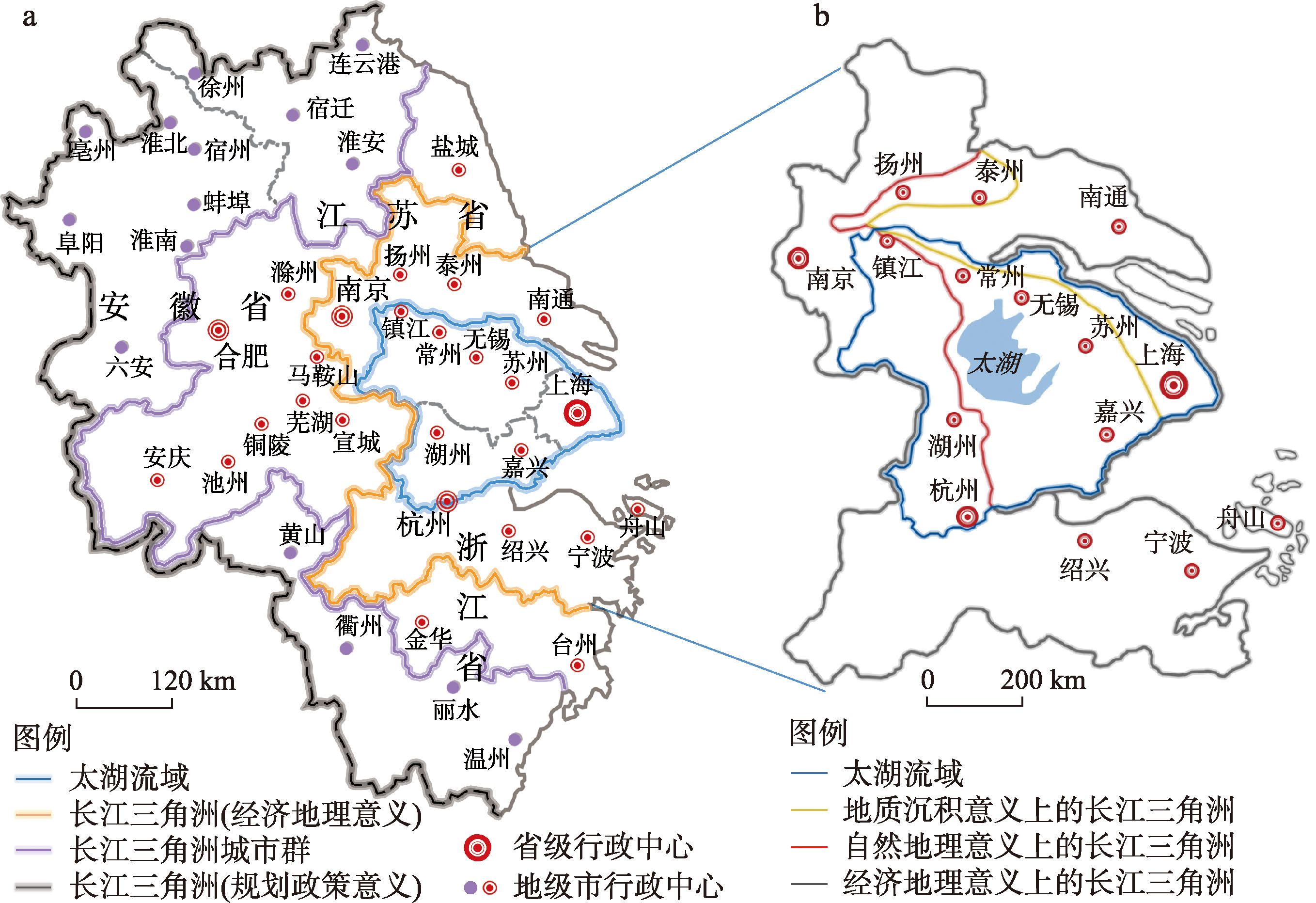
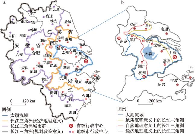
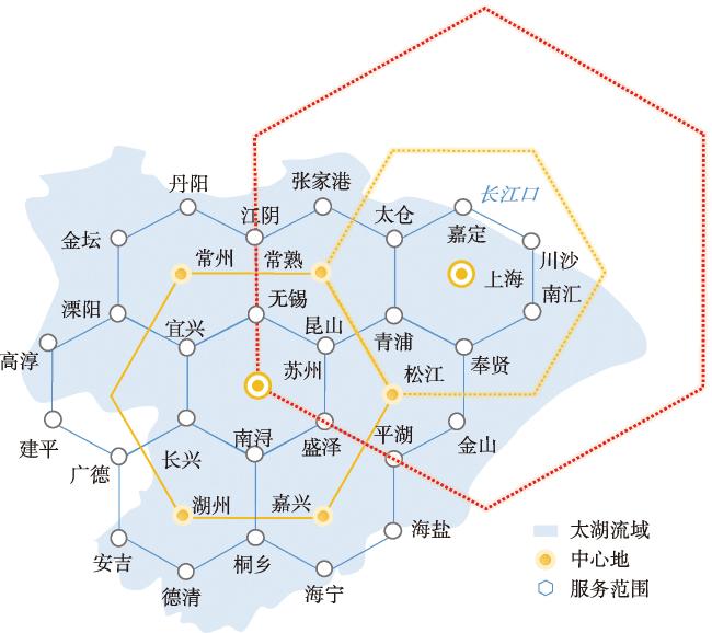
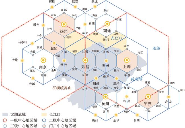
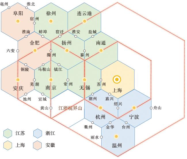
作为沿海轴线和沿江轴线交汇枢纽地域的长江三角洲,空间结构演化具有复杂性、多样性和典型性特征,对其演化规律与理论模型的提炼具有重要的理论意义和应用价值。按照核心边缘结构理论,长江三角洲可分为以太湖流域为主体的核心区和其余的边缘区,但由于位居江海之交,故边缘区中发展出了门户区,从而形成了核心区与门户区构成的空间结构类型。其中,核心区在早期以苏州为中心城市,在古代就形成了非常完善的5级中心地结构;在不同时期,门户区一直在发生变化,分别形成了古代以扬州为核心的运河门户群、近代以上海为核心的近海门户群和当代以宁波为核心的远洋门户群,所对应的通航等级分别为500 t、10000 t和200000 t。由此,在现有中心地理论和海港空间结构理论之外,长江三角洲的空间结构演化则提供了一种新的演化模式,即中心地与港口门户的融合演化模式:早期是核心区空间结构的内生型演化,符合克氏六边形结构规律;进入近代以后,长江三角洲空间结构类型的演化就不再是中心地主导型,而是转换成为门户主导型,且k = 3市场原则走向了k = 4交通原则。这样,对于中心地学说的过程性检验、城市中心性与门户性的功能属性分析,以及在此基础上的理论模式提炼,长江三角洲提供了全球最佳的实证检验与示范案例。
陆玉麒 . 长江三角洲空间结构演化规律与理论模型[J]. 地理学报, 2024 , 79(12) : 3015 -3029 . DOI: 10.11821/dlxb202412006
Yangtze River Delta, as a pivotal region where the coastal axis and the riverside axis intersect, is characterized by complexity, diversity and typicality of the spatial structural evolution. Therefore, understanding its evolutionary pattern and constructing a theoretical model has important theoretical significance and application value. According to the core-periphery structure theory, the Yangtze River Delta can be divided into a core area that is centered on the Taihu Lake Basin and remaining periphery areas. However, due to its location at the junction of the river and the sea, a gateway area has emerged within the periphery area, thus forming a spatial structure that is composed of the core area and the gateway area. In the early period, the core area was centered on Suzhou, and a five-tier central place structure became well established since ancient times. However, the gateway area kept evolving and underwent three main changes: in ancient times, the gateway area was centered on Yangzhou, forming the canal gateway cluster; in the modern age, the gateway area became centered on Shanghai, forming an offshore gateway cluster; and in the contemporary era, the gateway area became centered on Ningbo, forming an oceanic gateway cluster. Their corresponding navigation capacities were 500 t, 10,000 t, and 200,000 t, respectively. Therefore, in addition to the existing central place theory and seaport spatial structure theory, the spatial structure evolution of the Yangtze River Delta presents a new evolutionary model: namely, the fusion evolutionary model of central places and port gateways. According to this model, in the early period, it was an endogenous evolution of the core area's spatial structure, which was in line with Christaller's hexagonal structure; while in modern times, the evolution of the spatial structure of the Yangtze River Delta was no longer dominated by central places, but rather, it became dominated by the gateway areas, making the k = 3 market principle turn into the k = 4 transportation principle. In this way, the Yangtze River Delta provides a globally exemplary empirical case for validating the process test of the central place theory, analyzing functional attributes of urban centrality and gateway, and refining the relevant theoretical model.
笔者对于长江三角洲的系统研究,源于20年前陆大道主持的国家自然科学基金重点项目“中国区域开发地学基础的综合研究”(40131010)。在项目实施过程中,笔者负责专题研究长江三角洲的空间结构与区域发展,本文是对以往相关研究成果的进一步总结提炼与补充拓展。
| [1] |
[陆大道. 二○○○年我国工业生产力布局总图的科学基础. 地理科学, 1986, 6(2): 110-118.]
|
| [2] |
[陆大道. 我国区域开发的宏观战略. 地理学报, 1987, 42(2): 97-105.]
|
| [3] |
[陆大道. 区位论及区域研究方法. 北京: 科学出版社, 1988.]
|
| [4] |
[陆大道, 等. 中国工业布局的理论与实践. 北京: 科学出版社, 1990.]
|
| [5] |
[陆大道. 区域发展及其空间结构. 北京: 科学出版社, 1995.]
|
| [6] |
[陆大道, 刘毅, 樊杰. 我国区域政策实施效果与区域发展的基本态势. 地理学报, 1999, 54(6): 496-508.]
|
| [7] |
[陆大道. 论区域的最佳结构与最佳发展—提出“点—轴系统”和“T”型结构以来的回顾与再分析. 地理学报, 2001, 56(2): 127-135.]
|
| [8] |
[陆大道, 杨勤业, 吴绍洪, 等. 中国区域发展的理论与实践. 北京: 科学出版社, 2003.]
|
| [9] |
[陆大道. 关于“点—轴”空间结构系统的形成机理分析. 地理科学, 2002, 22(1): 1-6.]
|
| [10] |
[陆玉麒. 论点—轴系统理论的科学内涵. 地理科学, 2002, 22(2): 136-143.]
|
| [11] |
[张莉, 陆玉麒. “点—轴系统”的空间分析方法研究: 以长江三角洲为例. 地理学报, 2010, 65(12): 1534-1547.]
|
| [12] |
[段学军, 虞孝感,
|
| [13] |
[张莉, 陆玉麒. 基于陆路交通网的区域可达性评价: 以长江三角洲为例. 地理学报, 2006, 61(12): 1235-1246.]
|
| [14] |
[罗小龙, 沈建法. 长江三角洲城市合作模式及其理论框架分析. 地理学报, 2007, 62(2): 115-126.]
|
| [15] |
[姚士谋, 陈爽. 长江三角洲地区城市空间演化趋势. 地理学报, 1998, 53(S1): 1-10.]
|
| [16] |
[吴威, 曹有挥, 曹卫东, 等. 长江三角洲公路网络的可达性空间格局及其演化. 地理学报, 2006, 61(10): 1065-1074.]
|
| [17] |
[张晓明. 长江三角洲巨型城市区特征分析. 地理学报, 2006, 61(10): 1025-1036.]
|
| [18] |
[
|
| [19] |
[刘雅媛, 张学良. “长江三角洲”概念的演化与泛化: 基于近代以来区域经济格局的研究. 财经研究, 2020, 46(4): 94-108.]
|
| [20] |
[佘之祥. 长江三角洲水土资源与区域发展. 合肥: 中国科学技术大学出版社, 1997.]
|
| [21] |
[陆玉麒, 董平. 明清时期太湖流域的中心地结构. 地理学报, 2005, 60(4): 587-596.]
|
| [22] |
[张学恕. 中国长江下游经济发展史. 南京: 东南大学出版社, 1990.]
|
| [23] |
[周一星. 主要经济联系方向论. 城市规划, 1998, 22(2): 22-25.]
|
| [24] |
|
| [25] |
|
| [26] |
|
| [27] |
[尹国康. 流域地貌系统. 南京: 南京大学出版社, 1991.]
|
| [28] |
[任美锷. 中国的三大三角洲. 北京: 高等教育出版社, 1994.]
|
| [29] |
[陆玉麒, 李平华. 三角洲顶点城市探讨. 地域研究与开发, 2006, 25(1): 6-9, 38.]
|
| [30] |
[邓端本. 广州港史:古代部分. 北京: 海洋出版社, 1986.]
|
| [31] |
[李平日, 黄镇国, 宗永强, 等. 韩江三角洲. 北京: 海洋出版社, 1987.]
|
| [32] |
[陆玉麒. 中国空间格局的规律认知与理论提炼. 地理学报, 2021, 76(12): 2885-2897.]
|
| [33] |
[沃尔特⋅克里斯塔勒. 德国南部中心地原理. 常正文, 王兴中, 译. 北京: 商务印书馆, 2011.]
|
| [34] |
|
| [35] |
|
| [36] |
|
| [37] |
|
| [38] |
[施坚雅. 中国农村的市场和社会结构. 史建云, 徐秀丽, 译. 北京: 中国社会科学出版社, 1998.]
|
| [39] |
|
/
| 〈 |
|
〉 |