
城市网络视角下的中国科技创新功能区划研究
|
马海涛(1979-), 男, 山东滕州人, 博士, 副研究员, 硕士生导师, 中国地理学会会员(S110008167M), 主要从事城市网络与创新研究。E-mail: maht@igsnrr.ac.cn |
收稿日期: 2022-09-07
修回日期: 2022-11-02
网络出版日期: 2022-12-29
基金资助
国家自然科学基金项目(41971209)
国家自然科学基金项目(41571151)
第三次新疆综合科学考察项目(2021xjkk0900)
国家社会科学基金重大项目(21ZDA011)
Regionalization of scientific and technological innovation in China:From the perspective of urban network
Received date: 2022-09-07
Revised date: 2022-11-02
Online published: 2022-12-29
Supported by
National Natural Science Foundation of China(41971209)
National Natural Science Foundation of China(41571151)
The Third Xinjiang Scientific Expedition Program(2021xjkk0900)
National Social Science Foundation of China(21ZDA011)
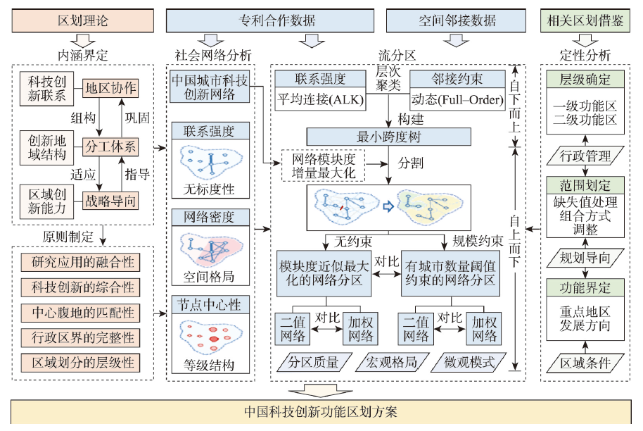
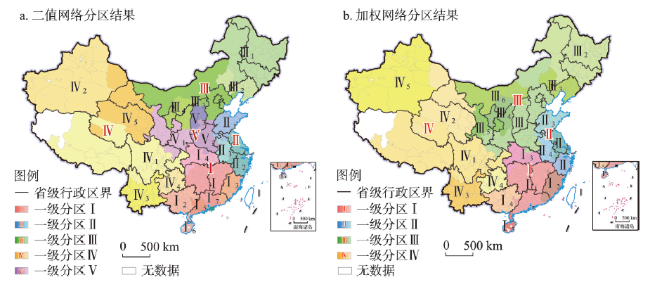
开展科技创新功能区划是全局把握国家科技创新总体布局并指导提升区域科技创新能力极为重要的基础性工作,然而相关研究仍较滞后。本文从城市间创新合作关系网络的角度,结合已有地理区划理论和创新地理研究,设计了一种科技创新功能区划方法,基于中国357个城市间2017—2019年的专利合作关系数据,研制了一套中国科技创新功能区划方案。研究认为,将网络空间拓扑关系与地理空间位置关系相结合,借助空间邻接约束下的层次聚类与以模块度为依据的图分割技术,可以得到内部联系紧密且占据一定连续地表的区划结果,是一种科技创新功能区划的有效方法。在城市科技创新网络拓扑结构分析和二值与加权网络分区结果对比分析的基础上,研制出一套包含4个一级区和20个二级区的中国科技创新功能区划参考方案,将中国大致划分为北方、南方、东部、西部4个科技创新功能板块,每个板块包含4~6个二级功能区。这一方案的分区边界与省级行政边界具有较高的吻合性,可为国家从宏观层面进行科技创新统筹管理提供辅助参考。建议未来依托科技创新功能区的建设与区域科技创新中心的引领,因地制宜实施区域创新发展战略,更好地为国家创新驱动发展战略实施贡献力量。
马海涛 , 胡夏青 . 城市网络视角下的中国科技创新功能区划研究[J]. 地理学报, 2022 , 77(12) : 3104 -3124 . DOI: 10.11821/dlxb202212011
Carrying out the functional regionalization of scientific and technological innovation in China is a basic work to grasp the overall configuration and guide the improvement of China's scientific and technological innovation capabilities. However, there are still large gaps in related research. Under the background of China's innovation-driven development strategy, the planning and construction of regional scientific and technological centers is considered an important task at present, which makes the functional regionalization of scientific and technological innovation in China urgently needed due to its guiding significance. From the perspective of intercity innovation cooperation network, combined with the existing geographical regionalization theories and innovation geography research, this paper devices a functional regionalization method for scientific and technological innovation in China by applying the dynamically contiguity-constrained hierarchical agglomerative clustering and the graph partitioning technology based on modularity. With the intercity patent cooperation data of 357 cities in China from 2017 to 2019 and their spatial contiguity data as an input, the topological relationship in the network space and the positional relationship in geographical space are combined to form regions covering continuous earth's surface which are tightly knit inside and show prominent regional characteristics in the scientific and technological innovation field. Based on the topological structure analysis of the urban network and the comparison between the regionalization results of the binary network and the weighted network, a regionalization scheme containing 4 first-level functional regions and 20 second-level functional regions is formulated. According to the regionalization, China is divided into four functional plates of scientific and technological innovation: north, south, east and west, each of which contains 4 to 6 secondary functional regions. The delimitation of scientific and technological innovation according to the regionalization results is highly consistent with the administrative divisions on the provincial level, providing reference for government to plan the overall management of scientific and technological innovation on macroscale. It is suggested that in the future, relying on the construction of the functional regions and the leadership of the regional central cities, all regions should formulate regional innovation and development strategies according to local conditions, and actively contribute to the implementation of the national innovation-driven development strategy.
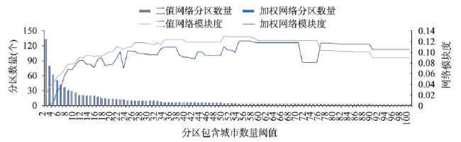
图6 不同阈值约束下网络分区结果的模块度(Q)变化Fig. 6 The modularity (Q) of the regionalization with different constraints of thresholds |
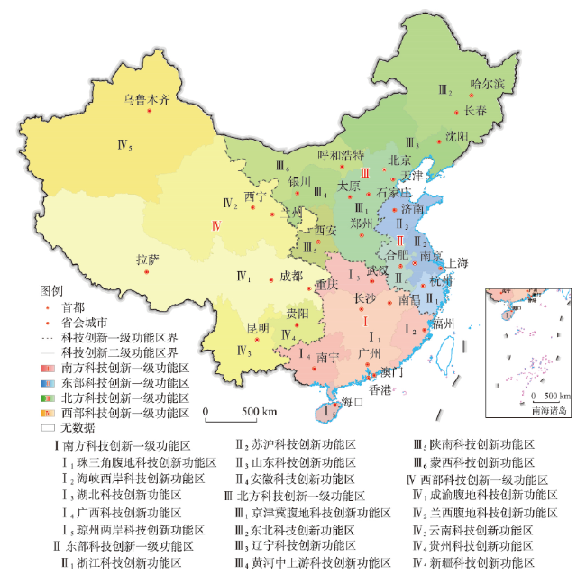
图8 中国科技创新功能区划的参考方案注:基于自然资源部标准地图服务网站审图号为GS(2020)4630号标准地图制作,底图边界无修改。 Fig. 8 A reference scheme for the functional regionalization of scientific and technological innovation in China |
表1 中国科技创新一级功能区各项指标概览Tab. 1 An overview of the indicators of the first-level functional regions for scientific and technological innovation in China |
| 名称与范围 | 网络指标 | 经济指标 | |||||||||||||
|---|---|---|---|---|---|---|---|---|---|---|---|---|---|---|---|
| 一级区域单元代码 | 名称 (科技创新一级功能区) | 行政区范围 | 二级区域单元数量(个) | 城市节点数量(个) | 局部网络密度 | 局部加权网络密度 | 局部网络模块度 | 局部加权网络模块度 | 年末人口(万人) | 人均GDP(万元/人) | R&D人员全时当量(人年) | R&D经费投入强度(%) | 国内专利申请量(项) | ||
| I | 南方 | 粤、湘、赣、闽、鄂、桂、琼、港、澳 | 5 | 103 | 0.107 | 1.870 | 0.040 | 0.053 | 39725 | 7.38 | 1606697 | 2.34 | 1610067 | ||
| II | 东部 | 沪、苏、浙、皖、鲁 | 4 | 57 | 0.395 | 7.829 | 0.032 | 0.039 | 33703 | 9.43 | 2016533 | 2.85 | 1976373 | ||
| III | 北方 | 京、津、冀、晋、豫、黑、吉、辽、陕、宁、蒙 | 6 | 105 | 0.112 | 2.086 | 0.038 | 0.017 | 39921 | 6.02 | 1074957 | 2.40 | 943519 | ||
| IV | 西部 | 川、渝、藏、青、陇、云、黔、新 | 5 | 92 | 0.054 | 0.388 | 0.021 | 0.012 | 27664 | 5.81 | 536324 | 1.69 | 465326 | ||
注:各项经济指标为2020年数据,来源于《中国统计年鉴2021》《中国科技统计年鉴2021》;数据暂未含港澳地区。 |
| [1] |
[ 甄峰, 黄朝永, 罗守贵. 区域创新能力评价指标体系研究. 科学管理研究, 2000, 18(6): 5-8.]
|
| [2] |
|
| [3] |
[ 马海涛, 陶晓丽. 区域科技创新中心内涵解读与功能研究. 发展研究, 2022, 39(2): 64-70.]
|
| [4] |
[ 王业强, 郭叶波, 赵勇, 等. 科技创新驱动区域协调发展: 理论基础与中国实践. 中国软科学, 2017(11): 86-100.]
|
| [5] |
[ 杜德斌, 段德忠. 全球科技创新中心的空间分布、发展类型及演化趋势. 上海城市规划, 2015(1): 76-81.]
|
| [6] |
[ 叶玉瑶, 王景诗, 吴康敏, 等. 粤港澳大湾区建设国际科技创新中心的战略思考. 热带地理, 2020, 40(1): 27-39.]
|
| [7] |
[ 牛方曲, 刘卫东. 中国区域科技创新资源分布及其与经济发展水平协同测度. 地理科学进展, 2012, 31(2): 149-155.]
|
| [8] |
[ 李哲, 申玉铭, 曾春水. 中国省域科技创新模式及其时空演变. 地理研究, 2018, 37(6): 1223-1237.]
|
| [9] |
[ 刘汉初, 樊杰, 周侃. 中国科技创新发展格局与类型划分: 基于投入规模和创新效率的分析. 地理研究, 2018, 37(5): 910-924.]
|
| [10] |
[ 郑度, 欧阳, 周成虎. 对自然地理区划方法的认识与思考. 地理学报, 2008, 63(6): 563-573.]
|
| [11] |
[ 黄秉维. 中国综合自然区划草案. 科学通报, 1959(18): 594-602.]
|
| [12] |
[ 倪健, 陈仲新, 董鸣, 等. 中国生物多样性的生态地理区划. 植物学报, 1998, 40(4): 370-382.]
|
| [13] |
[ 郑景云, 尹云鹤, 李炳元. 中国气候区划新方案. 地理学报, 2010, 65(1): 3-12.]
|
| [14] |
|
| [15] |
|
| [16] |
|
| [17] |
[ 张闯. 从层级到网络:城市间关系研究的演进. 财经问题研究, 2009(3): 22-27.]
|
| [18] |
[ 马海涛. 基于人才流动的城市网络关系构建. 地理研究, 2017, 36(1): 161-170.]
|
| [19] |
[ 钱肖颖, 孙斌栋. 基于城际创业投资联系的中国城市网络结构和组织模式. 地理研究, 2021, 40(2): 419-430.]
|
| [20] |
|
| [21] |
|
| [22] |
|
| [23] |
[ 赵海军. 论科技区划. 陕西师大学报(自然科学版), 1994, 22(1): 63-66.]
|
| [24] |
[ 刘燕华, 郑度, 葛全胜, 等. 关于开展中国综合区划研究若干问题的认识. 地理研究, 2005, 24(3): 321-329.]
|
| [25] |
[ 张海燕, 樊江文, 黄麟, 等. 中国自然资源综合区划理论研究与技术方案. 资源科学, 2020, 42(10): 1870-1882.]
|
| [26] |
[ 郑度, 葛全胜, 张雪芹, 等. 中国区划工作的回顾与展望. 地理研究, 2005, 24(3): 330-344.]
|
| [27] |
[ 方创琳, 刘海猛, 罗奎, 等. 中国人文地理综合区划. 地理学报, 2017, 72(2): 179-196.]
|
| [28] |
[ 樊杰. 中国主体功能区划方案. 地理学报, 2015, 70(2): 186-201.]
|
| [29] |
[ 赵松乔. 中国综合自然地理区划的一个新方案. 地理学报, 1983, 38(1): 1-10.]
|
| [30] |
[ 傅伯杰, 刘国华, 陈利顶, 等. 中国生态区划方案. 生态学报, 2001, 21(1): 1-6.]
|
| [31] |
[ 傅伯杰, 冷疏影, 宋长青. 新时期地理学的特征与任务. 地理科学, 2015, 35(8): 939-945.]
|
| [32] |
[ 彭建, 杜悦悦, 刘焱序, 等. 从自然区划、土地变化到景观服务:发展中的中国综合自然地理学. 地理研究, 2017, 36(10): 1819-1833.]
|
| [33] |
[ 刘闯. 中尺度对地观测系统支持下中国综合自然地理区划新方法论研究. 地理科学进展, 2004, 23(6): 1-9.]
|
| [34] |
|
| [35] |
|
| [36] |
|
| [37] |
|
| [38] |
|
| [39] |
[ 钮心毅, 王垚, 刘嘉伟, 等. 基于跨城功能联系的上海都市圈空间结构研究. 城市规划学刊, 2018(5): 80-87.]
|
| [40] |
|
| [41] |
|
| [42] |
[ 廖倩, 吕拉昌, 黄茹. 基于文献计量的中国创新地理研究进展. 地域研究与开发, 2016, 35(5): 1-6.]
|
| [43] |
[ 柳卸林, 胡志坚. 中国区域创新能力的分布与成因. 科学学研究, 2002, 20(5): 550-556.]
|
| [44] |
[ 胡海鹏, 吕拉昌, 黄茹, 等. 基于创新流视角的广东省城市创新体系与职能. 城市发展研究, 2015, 22(6): 71-76.]
|
| [45] |
[ 马海涛. 知识流动空间的城市关系建构与创新网络模拟. 地理学报, 2020, 75(4): 708-721.]
|
| [46] |
|
| [47] |
|
| [48] |
|
| [49] |
|
| [50] |
[ 万幼, 刘耀林. 基于地理加权中心节点距离的网络社区发现算法. 武汉大学学报(信息科学版), 2019, 44(10): 1545-1552.]
|
| [51] |
|
| [52] |
|
| [53] |
[ 马海涛, 黄晓东, 李迎成. 粤港澳大湾区城市群知识多中心的演化过程与机理. 地理学报, 2018, 73(12): 2297-2394.]
|
| [54] |
|
| [55] |
|
| [56] |
|
/
| 〈 |
|
〉 |