
横断山区泥石流空间格局和激发雨量分异性研究
收稿日期: 2019-05-14
要求修回日期: 2019-10-09
网络出版日期: 2019-11-01
基金资助
国家重点基础研究发展计划项目(973计划)(2015CB452704)
国家重点研发计划(2018YFC1505205)
四川省九寨沟地震灾区生态化地质灾害防治重大科技支撑研究课题(KJ-2018-23)
版权
Spatial pattern of debris-flow catchments and the rainfall amount of triggering debris flows in the Hengduan Mountains region
Received date: 2019-05-14
Request revised date: 2019-10-09
Online published: 2019-11-01
Supported by
The National Basic Research Program of China(2015CB452704)
National Key R&D Program of China(2018YFC1505205)
Major Research Program of Ecological Prevention against Geohazards in the Jiuzhaigou Earthquake Area by Sichuan Government(KJ-2018-23)
Copyright
地形、降雨等环境因子决定了泥石流的时空分布特征,理解泥石流与这些因子的关系有助于区域泥石流灾害风险评估与防灾减灾工作。以横断山区为研究区域,选取降水、气候、地貌、地质、土地覆盖、土壤厚度、高差势能以及湿度指数等因子,利用地理探测器和灰度关联分析等方法,探讨了环境因子与泥石流沟空间分布的关系以及降水特征与泥石流灾害的时间关联性。结果表明,湿度指数是决定泥石流沟空间格局的最主要因子,其次是高差势能和土壤厚度,多年平均分布的降水特征对泥石流沟分布的影响较小。泥石流灾害事件与降水特征的时间关联具有较大的区域异质性。泥石流发生地的激发雨量、湿度指数、高差及土壤厚度的统计分布在不同地貌、地质和气候单元中有明显差异。这表明泥石流预警不仅需要考虑雨量等激发因子,还必须考虑其他影响因素的空间差异性。
胡凯衡 , 魏丽 , 刘双 , 李秀珍 . 横断山区泥石流空间格局和激发雨量分异性研究[J]. 地理学报, 2019 , 74(11) : 2303 -2313 . DOI: 10.11821/dlxb201911008
Environmental factors determine the spatial and temporal distribution of debris flows. Understanding the relationship between debris flows and their effective factors is important for debris flows risk assessment at regional scale. In this paper, geographic detectors and gray correlation analysis are used to explore the relationship between 11 influencing factors, including precipitation, climate, landforms, geology, land cover type, soil thickness and topographic wetness, and the spatial distribution of debris flows-prone catchments, as well as the spatial and temporal correlation between precipitation and debris flows disasters in the Hengduan Mountains region. The results show that the topographic wetness index is the most dominant factor controlling the spatial distribution of the catchments, followed by topographic relief and soil thickness. Temporal correlation between debris flows disasters and precipitation characteristics has large regional heterogeneity. The rainfall characteristics of debris flows disaster events in different regions exhibit significant difference. The frequency of debris flows with rainfall, topographic wetness, topographic relief and soil thickness in the Hengduan Mountains region varies significantly in different zones, which indicates that not only the rainfall but also the other factors controlling the spatial pattern of debris flows should be reflected in debris flows early warning model in the region.
表1 6类子区的基本特征Tab. 1 Characteristics of the six sub-regions of Hengduan Mountains region |
| 区编号 | 最低海拔(m) | 最高海拔(m) | 海拔标准差(m) | 气候类型 | 地貌类型 | 地质类型 |
|---|---|---|---|---|---|---|
| 子区1 | 322 | 6998 | 654 | 东部季风 | 云贵川高中山山原 | 华南和亲华南陆块群 |
| 子区2 | 669 | 4362 | 502 | 东部季风 | 云贵川高中山山原 | 冈瓦纳和亲冈瓦纳大陆陆块群 |
| 子区3 | 773 | 7447 | 767 | 东部季风 | 横断高山山原 | 华南和亲华南陆块群 |
| 子区4 | 290 | 5846 | 725 | 东部季风 | 横断高山山原 | 冈瓦纳和亲冈瓦纳大陆陆块群 |
| 子区5 | 1479 | 6144 | 491 | 青藏高寒 | 横断高山山原 | 华南和亲华南陆块群 |
| 子区6 | 1954 | 6629 | 471 | 青藏高寒 | 横断高山山原 | 冈瓦纳和亲冈瓦纳大陆陆块群 |
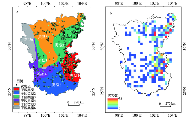
图2 横断山区不同类型子区与泥石流灾害分布(a. 根据不同气候、地质及地貌类型组合得到的6个子区及泥石流灾害点分布; b. 25 km网格化的泥石流灾害数的空间分布)Fig. 2 Sub-regions and debris flow events in Hengduan Mountains region (a. Six kinds of sub-regions classified with the climate, geology and landform types and the debris flow events; b. Spatial distribution of debris flow events with 25 km×25 km grids) |
表2 数据资料来源Tab. 2 Data sources in this study |
| 数据名称 | 时间 | 数据来源 | 数据格式 |
|---|---|---|---|
| 泥石流灾害事件 | 1998-2017 | 文献、新闻搜集 | 点状图层 |
| 泥石流沟 | 水工环地质信息服务平台 | 点状图层 | |
| 年平均降雨量 | 1998-2017 | TRMM 3B42v7 | 25 km×25 km格网 |
| 日降水量分别大于10 mm、25 mm及50 mm的20年平均总天数 | 1998-2017 | TRMM 3B42v7 | 25 km×25 km格网 |
| 地貌分区 | 1989 | 文献[2] | 面图层 |
| 地质分区 | 1989 | 文献[23] | 面图层 |
| 气候分区 | 1989 | 文献[24] | 面图层 |
| 土地覆盖 | 2000 | 寒区旱区科学数据中心 | 1 km×1 km格网 |
| 土壤厚度 | 2000 | 中山大学陆气相互作用研究工作组 | 10 km×10 km格网 |
| 高程 | 2000 | STRM | 90 m×90 m格网 |
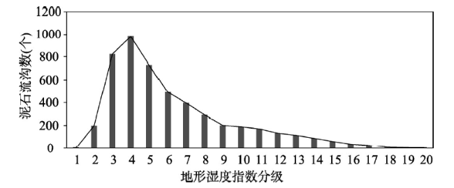
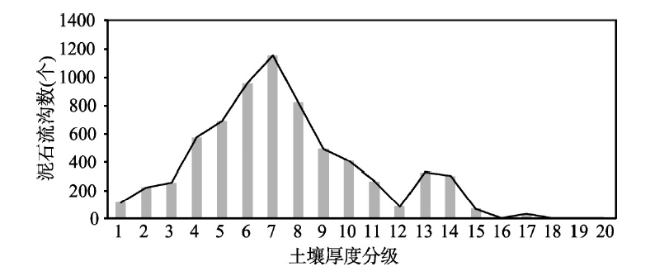
图4 横断山区泥石流沟数量随地形湿度指数的分布情况Fig. 4 Histogram of debris-flow catchments with topographic wetness index of the Hengduan Mountains region |
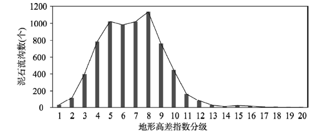
图5 横断山区泥石流沟数量随地形高差的分布情况Fig. 5 Histogram of debris-flow catchments with relative elevation of the Hengduan Mountains region |
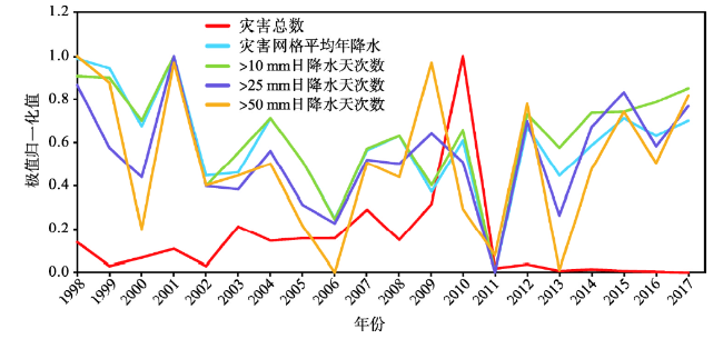
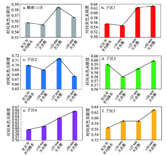
图8 横断山区灾害网格平均年降水及日降水量> 10 mm、> 25 mm、> 50 mm的天次数与灾害总数的灰色关联度Fig. 8 Grey correlation degree between average annual precipitation and daily precipitation over 10, 25 and 50mm in the grid of Hengduan Mountain disaster and the total number of disasters in (a) the whole Hengduan Mountains region and (b-f) the first to the fifth sub-regions |
| [1] |
[ 郑度 . 横断山区自然地域分异和区划. 山地学报, 1989,7(1):1-2.]
|
| [2] |
[ 李炳元 . 横断山区地貌区划. 山地研究, 1989,7(1):13-20.]
|
| [3] |
[ 吕儒仁, 李德基 . 横断山区泥石流活动特点形成条件及防治问题. 山地学报, 1986,4(1):37-44, 116.]
|
| [4] |
[ 崔鹏, 贾洋, 苏凤环 , 等. 青藏高原自然灾害发育现状与未来关注的科学问题. 中国科学院院刊, 2017,32(9):985-992.]
|
| [5] |
[ 崔鹏, 庄建琦, 陈兴长 , 等. 汶川地震区震后泥石流活动特征与防治对策. 四川大学学报(工程科学版), 2010,42(5):10-19.]
|
| [6] |
|
| [7] |
[ 秦大河, 张建云, 闪淳昌 , 等. 中国极端天气气候事件和灾害风险管理与适应国家评估报告, 北京: 科学出版社, 2015.]
|
| [8] |
|
| [9] |
|
| [10] |
|
| [11] |
[ 唐川, 梁京涛 . 汶川震区北川9.24暴雨泥石流特征研究. 工程地质学报, 2008,16(6):751-758.]
|
| [12] |
|
| [13] |
|
| [14] |
|
| [15] |
[ 马超, 何晓燕, 胡凯衡 . 汶川地震灾区泥石流群发雨量及预警等级划分. 北京林业大学学报, 2015,37(9):37-44.]
|
| [16] |
[ 雷发洪, 胡凯衡, 胡云华 , 等. 汶川地震灾区震后泥石流激发雨量研究. 灾害学, 2014,29(2):199-203.]
|
| [17] |
[ 丁明涛, 王骏, 程尊兰 , 等. 岷江上游土地利用类型对泥石流灾害的敏感性. 山地学报, 2015,33(5):587-596.]
|
| [18] |
[ 丁俊, 王军 . 四川省大渡河流域地质灾害分布及其发展趋势浅析. 中国地质灾害与防治学报, 2007,18(S1):22-25.]
|
| [19] |
[ 边江豪, 李秀珍, 胡凯衡 . 横断山区山地灾害的区域分布特征与动态演化规律研究. 工程地质学报, 2018,26(s):6-13.]
|
| [20] |
[ 胡凯衡, 陈成, 李秀珍 , 等. 地震区降雨作用下泥石流易发性动态评估. 中国地质灾害与防治学报, 2018,29(2):1-8.]
|
| [21] |
The Qinghai-Tibet Plateau Comprehensive Science Research Team of the Chinese Academy of Sciences,
[ 中国科学院青藏高原综合科学考察队, 张荣祖, 郑度 , 等. 横断山区自然地理. 北京: 科学出版社, 1997.]
|
| [22] |
[ 潘裕生 . 横断山区地质构造分区. 山地研究, 1989,7(1):3-12.]
|
| [23] |
|
| [24] |
[ 王劲峰, 徐成东 . 地理探测器: 原理与展望. 地理学报, 2017(1):116-134.]
|
| [25] |
|
| [26] |
[ 邓慧平, 李秀彬 . 地形指数的物理意义分析. 地理科学进展, 2002,21(2):103-110.]
|
| [27] |
[ 张谊光 . 横断山区气候区划. 山地研究, 1989,7(1):21-28.]
|
| [28] |
|
| [29] |
[ 庄建琦, 崔鹏, 葛永刚 , 等. 降雨特征与泥石流总量的关系分析. 北京林业大学学报, 2009,31(4):77-83.]
|
| [30] |
|
/
| 〈 |
|
〉 |
