张东良 , 兰波
, 兰波
ZHANG Dongliang, LAN Bo
收稿日期: 2017-05-1
修回日期: 2016-07-22
网络出版日期: 2017-09-30
版权声明: 2017 《地理学报》编辑部 本文是开放获取期刊文献,在以下情况下可以自由使用:学术研究、学术交流、科研教学等,但不允许用于商业目的.
基金资助:
作者简介:
作者简介:张东良(1990-), 男, 汉族, 甘肃省通渭人, 博士研究生, 主要从事中亚过去气候变化研究。E-mail: zhdlxieg@163.com
展开
摘要
常年受到西风影响的阿尔泰山地区,是古气候研究的重点区域之一。利用阿尔泰山北部和南部的11个气象站观测数据和已发表的古气候数据(包括树轮、冰芯和湖芯),详细对比了不同时间尺度上(季节、年、几十年、百年和千年尺度)阿尔泰山北部和南部的降水变化。结果表明,阿尔泰山北部器测时段降水是逐渐下降的,而阿尔泰山南部降水反而呈现逐渐增加的趋势。这种反相的降水关系也体现在过去200年、过去1000年和全新世时段,说明阿尔泰山北部和南部降水在季节、年、几十年、百年和千年尺度上均存在相反的趋势。不同时间尺度上降水存在的相反关系表明阿尔泰山是一个重要的气候边界。但不同时间尺度上出现相反变化的原因需进一步详细探讨,这不仅有助于了解区域水汽变化的历史,也有助于加深理解欧亚草原丝绸之路文化的演替。
关键词:
Abstract
As one of the most important regions for paleoclimate study, the Altai Mountains are influenced by the prevailing westerly airflow throughout a year. In order to get a better understanding of the precipitation variations at different time scales (i.e., season, year, multi-decades, centennial and millennial scales) in the northern and southern Altai Mountains, we investigate the observed data from 11 meteorological stations and published paleoclimate documents (including tree rings, ice cores and lake cores) in the northern and southern Altai Mountains. The results show that the precipitation during the observed interval experiences a decreasing trend in the northern Altai Mountains, whereas an increasing trend in the southern Altai Mountains. The out-of-phase relationship of precipitation in the northern and southern Altai Mountains also exists in the two centennial intervals, the last millennium and the Holocene epoch. We propose that the out-of-phase relationships of precipitation variations at different time-scales (i.e., season, year, multi-decades, centennial and millennial scales) indicate that the Altai Mountains are an important climatic boundary. However, the reasons of out-of-phase relationship at different time-scales remains to be investigated in the future. The next work is not only helpful to understand the history of regional water vapor change, but also contributes to the understanding of the succession of the Silk Road culture along the Europe-Asian steppe.
Keywords:
常年受到西风影响的阿尔泰山地区,是古气候研究的重点区域之一(图1a)。该山脉呈西北—东南走向,耸立于亚洲腹地的干旱荒漠和干旱半荒漠地带,西部与哈萨克丘陵相连,北部与西西伯利亚平原比邻,东部与萨彦岭相靠,南部与准噶尔盆地相接。按阿尔泰山西北—东南走向可以将其分为北部和南部。阿尔泰山北部属于俄罗斯和蒙古,包括阿尔泰山北坡、萨彦岭和蒙古高原西部,山川众多、湖泊遍地是该区域的地理特点。山区发育河流主要有卡通河(鄂毕河左侧支流)、比亚河(鄂毕河右侧支流)。阿尔泰山南部属于中国和哈萨克斯坦,包括阿尔泰山南坡、准噶尔盆地和斋桑泊谷地,发育有额尔齐斯河和乌伦古河两大水系。
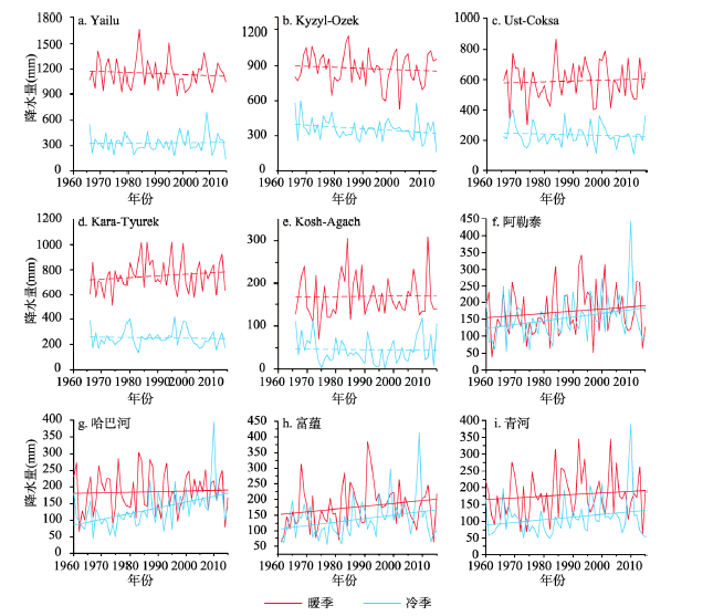
图1 研究区域及本文所选气候记录点示意图和各个气象站器测时段年降水量变化
Fig. 1 Map showing the study area and relevant study sites as well as annual precipitation variations of meteorological stations during the instrumental interval
近20年来,有关阿尔泰山全新世(即过去11500年前)气候变化研究已取得了相当丰硕的成果[1-10]。最近学者们对阿尔泰山北部和南部的古气候重建资料进行了综述,其中有两个综述较为突出。第一个是Ran等[11]综述的阿尔泰山南部(新疆北部)全新世资料。结果揭示新疆北部在过去8000年前以前气候较为干旱,约8000年以来区域湿度逐渐增加。第二个是Wang等[12]综述的阿尔泰山北部全新世资料。他们的结果揭示自全新世以来,阿尔泰山区域气候呈现逐渐变干的趋势。可见,阿尔泰山北部和南部全新世气候在千年尺度上呈现完全相反地变化。但是,这种相反的关系是否在其他时间尺度上(季节、年、十年、百年尺度)依然是存在的呢?本文将通过追踪阿尔泰山北部和南部已发表的不同时间段的气候记录(包括器测时段、过去200年时段和过去1000年时段),来讨论不同时间尺度上其北部和南部的降水(或水文)变化特征。
本文所选用器测降水数据来自11个气象站(5个位于俄罗斯境内、2个位于蒙古境内、4个位于中国境内),分布位置如图1所示,相关信息如表1所示。其中俄罗斯境内的5个气象站分别是Kyzyl-Ozek、Yailu、Ust-Coksa、Kosh-Agach和Kara-Tyurek,数据来自俄罗斯水文气象信息研究所,观测时段是1966-2015年。蒙古境内的两个气象站是Ulgii和Hovd,数据来自Malyigina等[13]文章,没有获得原始资料,观测时段是1959-2015年。中国境内的气象站分别是青河、富蕴、阿勒泰和哈巴河,数据来自中国气象局气象数据中心(http://data.cma.cn/),观察时段为1954-2015年。在本文的分析中,这11个气象站均选择的是月降水数据。
表1 阿尔泰山北部和南部气象站点的相关信息
Tab. 1 Information of meteorological stations in the northern and southern Altai Mountains
| 序号 | 气象站名 | 纬度 | 经度 | 海拔(m) | 暖季降水(mm) | 冷季降水(mm) | 年降水(mm) | |
|---|---|---|---|---|---|---|---|---|
| 阿尔泰山北部 | 1 | Kyzyl-Ozek | 51.90°N | 86.0°E | 331 | 569.3 | 160.2 | 729.5 |
| 2 | Yailu | 51.77°N | 87.6°E | 480 | 749.5 | 57.7 | 807.2 | |
| 3 | Ust-Coksa | 50.30°N | 85.6°E | 978 | 385.5 | 74.7 | 460.3 | |
| 4 | Kara-Tyurek | 50.00°N | 86.4°E | 2600 | 486.0 | 106.2 | 592.2 | |
| 5 | Kosh-Agach | 50.00°N | 88.4°E | 1760 | 105.3 | 16.5 | 121.7 | |
| 6 | Ulgii | 48.90°N | 91.9°E | 171 | 114.1 | 5.9 | 120.1 | |
| 7 | Hovd | 48.00°N | 91.4°E | 1400 | 121.6 | 7.0 | 128.6 | |
| 阿尔泰山南部 | 8 | 青河 | 46.67°N | 90.38°E | 1220 | 109.8 | 67.9 | 177.7 |
| 9 | 富蕴 | 46.98°N | 85.52°E | 826.6 | 106.5 | 83.7 | 190.1 | |
| 10 | 阿勒泰 | 47.03°N | 88.08°E | 736.9 | 107.0 | 92.9 | 200.0 | |
| 11 | 哈巴河 | 48.05°N | 86.40°E | 534 | 112.1 | 79.8 | 191.9 |
本文选择的过去200年时段的降水数据来自区域树轮和冰芯(冰芯仅在阿尔泰山 北部)的重建,分布位置如图1所示和相关信息如表2所示。本文选择的过去1000年时段的降水关联数据来自区域湖芯的重建,分布位置如图1所示和相关信息如表3所示。其中阿尔泰山北部过去1000年唯一的高分辨率(约11 a/cm)气候资料来自捷列茨科耶湖(Teletskoye湖)[14-15],阿尔泰山南部过去1000年唯一的高分辨率(约7 a/cm)气候资料来自铁力沙汗湖[16]。
表2 阿尔泰山北部和南部树轮和冰芯的相关信息
Tab. 2 Information of tree rings and ice core in the northern and southern Altai Mountains
| 位置 | 序号 | 研究区 | 方差解释量(%) | 序列长度(a) | 数据来源 |
|---|---|---|---|---|---|
| 阿尔泰 山北部 | 1 | Koksu、Mongun、Aktash | - | 200(1800-2005 AD) | Sidorova等[17] |
| 2 | Abakan附近 | 56 | 127(1875-2012 AD) | Shah等[18] | |
| 3 | Belukha冰芯 | - | 750(1250-2000 AD) | Henderson等[19] | |
| 阿尔泰 山南部 | 1 | 东南端 | 65.5 | 184(1825-2009 AD) | Chen等[20] |
| 2 | 西北端 | 40.7 | 252(1760-2012 AD) | Chen等[21] | |
| 3 | 西北端 | 36.6 | 524(1481-2004 AD) | 张同文等[22] | |
| 4 | 南部 | 40.7 | 188(1818-2006 AD) | 胡义成等[23] | |
| 5 | 东南端 | - | 221(1790-2011 AD) | Xu等[24] | |
| 6 | 南部 | 46.5 | 160(1850-2012 AD) | 张瑞波等[25] |
3.1.1 阿尔泰山北部 图1b~1e显示了阿尔泰山北部7个气象站器测时段的年降水变化情况,这些年降水变化均通过了95%的显著性检验,阿尔泰山南部的降水变化趋势也通过了95%的显著性检验。通过线性相关性分析发现,近50年来北部的7个气象站降水数据变化表现各异。具体来说,位于迎风坡的Kara-Tyurek站降水以0.9 mm/10a的速率增加,其他3个位于迎风坡的气象站(Kyzkl-Ozek、Yailu和Ust-Coksa)降水数据均呈现了逐渐下降的趋势,其中Kyzkl-Ozek年降水数据下降最快,达到2.38 mm/10a。位于阿尔泰山背风坡的3个气象站(Kosh-Agach、Ulgii和Hovid)降水数据在近50年没有出现较大变化。
进一步分析位于俄罗斯境内的5个气象站的暖季(4-9月)和冷季(10-次年3月)降水变化(图2)。需要说明的是由于缺乏蒙古境内的两个气象站的原始数据,故没有对其进行冷暖季节的降水分析。从图2可以看出,除Kara-Tyurek暖季降水有增加的趋势外,其余所有气象站数据无论是暖季还是冷季,降水均呈现了下降的趋势。其中Kyzkl-Ozek暖季和冷季降水数据下降最明显。
3.1.2 阿尔泰山南部 与阿尔泰山北部的7个气象站的年降水数据相比,阿尔泰山南部的4个气象站近50年的年降水数据增加速率远大于北部的变化(图1)。其中富蕴年降水增加最快,增加速率达19.25 mm/10a,远高于中亚天山的降水增加速率(8.4 mm/10a)[26]。这种降水增加趋势同样体现在暖季和冷季变化上(图2),富蕴仍然是暖季和冷季降水增加最快的气象站,增加速率分别是8.93 mm/10a和11.28 mm/10a。此外,4个气象站冷季降水增加速率大于暖季降水增加速率。这个变化与整个新疆北部的降水变化情况是一致的[26-27]。
图2 阿尔泰山北部(a~e)和南部(f~i)各气象站器测时段暖季和冷季降水量变化
Fig. 2 Warm-season and cold-season precipitation variations of meteorological stations in the northern (a~e) and southern (f~i) Altai Mountains.
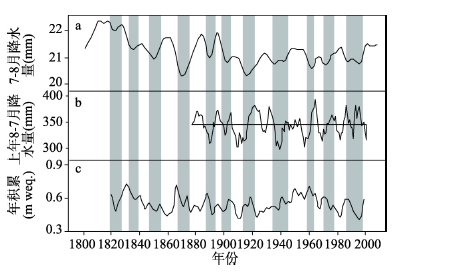
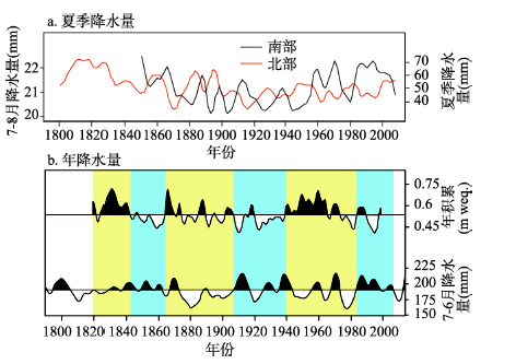
3.2.1 阿尔泰山北部 阿尔泰山北部树轮重建的降水序列仅扩展至过去200年,其树轮序列相关信息如表2所示。Sidorova等[17]利用西伯利亚落叶松树轮碳氧同位素重建了阿尔泰山北部的7-8月降水(图3a)。结果揭示约1800-1830年前降水较高,约1830-1880年时段降水逐渐下降,之后持续了近10年的高降水时段,随后降水量出现明显下降并呈现低值波动。Shah等[18]发表的松树树轮宽度资料揭示近一百年最干旱年份出现在1910-1914年、1940-1946年、1961-1965年,最湿润年份出现在1969-1973年、1993-1997年、2000-2004年(图3b)。此外,阿尔泰山北部Belukha冰芯揭示了过去200年的冰川积累量(图3c),结果揭示高积累时段出现在约1810-1845年、1860-1880年和1930-1990年;低积累时段出现在约1845-1860年、1880-1930年、1990年以来[19]。对比分析可以看出,阿尔泰山北部过去200年夏季降水量和年降水量波动基本是同步的。
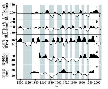
3.2.2 阿尔泰山南部 与阿尔泰山北部树轮重建的降水类似,阿尔泰山南部树轮降水重建也主要集中在过去200年,其树轮样点如图1a所示,树轮序列相关信息如表2所示。在年降水重建中,Chen等[20-21]选择西伯利亚云杉作为重建树种,主要考虑其生长在阿尔泰山南部受干旱胁迫,对区域降水十分敏感,其中降水变率的解释方差分别达到了65.5%(东南端)和40.7%(西北端)(图4a、4b),阿尔泰山南部东南端和西北端过去200年年降水(上年7月-6月)同步变化且降水量总体一致,高降水时段出现在1825-1828年、1839-1851年、1856-1875年、1889-1897年、1912-1918年、1924-1931年、1937-1942年、1956-1962年、1969-1972年和1985-2006年,低降水时段出现在1829-1838年、1852-1855年、1876-1888年、1898-1911年、1919-1923年、1932-1936年、1943-1955年、1963-1968年、1973-1984年和2007-2009年。
图3 阿尔泰山北部过去200年的降水量变化(a. 树轮同位素重建的7-8月降水量[
Fig. 3 Precipitation variations of the past 200 years in the northern Altai Mountains (a. Tree-ring isotope-based precipitation during June-August[
最近几位学者关注了阿尔泰山树轮所记录的季节降水变化[22-25]。对于夏季降水,重建结果揭示19世纪中期是夏季降水偏多期,19世纪末到20世纪中期降水整体偏少,随后至今是一个较长的降水偏多期[25](图4d)。对于冬季降雪,过去200年1-2月积雪量偏少时段出现在1867-1900年,持续了34年。积雪量偏多时段出现在1820-1866年、1901-1941年、1989-2002年。其中持续时间最长的阶段为1901-1941年,长达41年(图4e)[23]。作为温度和降水共同作用的夏季相对湿度(图4c)揭示从1790-1830年相对湿度呈现下降的趋势,最小值出现在1817-1830年。随后至1946年相对湿度围绕平均值上下波动,1946-1990年相对湿度较高,随后相对湿度开始下降,最低值出现在2004-2011年[24]。
图4 阿尔泰山南部树木记录的过去200年降水记录(a. Chen等[
Fig. 4 Precipitation variations of the past 200 years in the southern Altai Mountains (a. Chen et al.[
总体来看,阿尔泰山南部过去200年年降水具有同步变化的趋势(图4a、4b)。而对于夏季降水,虽然1915-1940年时段出现低降水(图4d),但增加的冬季积雪量(图4e)弥补了年降水出现低值,避免了阿尔泰山南部干旱的发生。此外,1985-2005年时段是过去200年最湿润时段(图4),得到了器测时段高降水的支持[26-27]。但是在2005年之后区域湿度指标均呈现明显地下降,尤其是夏季相对湿度(图4c),主要与此阶段下降的夏季降水和高温条件下加强的蒸发有关。但是对这种干旱现象出现的强度和持续时间还不清楚,需要进一步借助代用指标重建和相关模型进行分析和预测。同时值得关注的是,这一干旱对区域生态系统的影响。
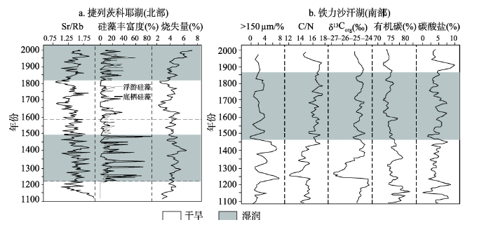
3.3.1 阿尔泰山北部 捷列茨科耶湖是阿尔泰山北部最大的淡水湖,湖盆体积约48 km3。湖区年平均降水约300 mm,年均夏季温度约12 ℃,年均冬季温度约-12.5 ℃(表3)。湖泊沉积物烧失量、地化指标和硅藻含量揭示了过去800年的气候信息(图5a):约1210-1480年高含量的浮游/底栖硅藻比率、Sr/Rb值和磁化信号表明区域气候暖湿。约1480-1580年沉积物烧失量降低,下降的Sr/Rb值表明湖泊侧向供应较低,同时底栖硅藻占主导,区域气候转向寒冷。约1580-1840年气候进一步变冷,湖泊沉积物中低的烧失量和硅藻丰富度、低Sr/Rb值和丰富的底栖硅藻表明气候是相当干的。自1840年以来气候逐渐向暖湿转变[15]。
表3 阿尔泰山北部和南部湖芯的相关信息
Tab. 3 Information of lacustrine cores in the northern and southern Altai Mountains
| 位置 | 研究区 | 纬度 | 经度 | 海拔(m) | 年均夏季温(℃) | 年均冬季温(℃) | 年均降水量(mm) | 数据来源 |
|---|---|---|---|---|---|---|---|---|
| 阿尔泰山北部 | 捷列茨科耶湖 | 54.65°N | 87.67°E | 434 | 11.5 | -12.5 | 300 | Andreev等[14];Kalugin等[15] |
| 阿尔泰山南部 | 铁力沙汗湖 | 48.82°N | 87.00°E | 1576 | 22 | -15 | 184 | Li等[16] |
图5 阿尔泰山北部和南部过去1000年资料对比图
Fig. 5 Comparison of paleodocuments of the past 1000 years in the northern and southern Altai Mountains
捷列茨科耶湖孢粉资料也揭示了与地化指标类似的气候变化情况[14]。具体来说,约1050-1100年时段冷杉和云杉含量较高、碳粒含量较低,表明区域气候相对湿润。约1100-1200年时段,大量出现的碳粒和较高含量的赤羊皮、桦木、蒿属、禾本科、藜科和水龙骨科孢粉表明气候相对冷干。接下来的时段(约1200-1410年)增加的孢粉浓度和相对较低含量的赤羊皮、桦木、蒿属、禾本科、藜科和水龙骨科孢粉含量及低频率的火灾事件,表明气候是湿润的。约1410-1560年时段明显增加的蒿属孢粉表明气候是干旱的。1560年以来区域气候持续变冷干。自1820年以来变湿的气候导致火灾事件明显下降,区域的植被覆盖状况接近于现代分布。
总体来看,捷列茨科耶湖沉积物中元素、硅藻、孢粉等指标揭示在约1050-1100年时段气候暖湿、约1100-1200年冷干、约1200-1480年暖湿、约1480-1820年冷干。自1820年以来区域气候开始好转[14-15]。这一序列气候资料的重建得到了更靠北的Shira湖(54.50°N,90.20°E)[28]和SIB04泥炭(56.80°N,78.73°E)[29]资料的支持。
3.3.2 阿尔泰山南部 铁力沙汗湖位于阿尔泰山南部西北端喀纳斯湖的西部,湖面积达0.02 km2。Li等[16]在210Pb、137Cs和AMS 14C测年基础上,利用湖芯地球化学指标重建了铁力沙汗湖过去1000年的气候/水文变化历史(图5b)。详细地讲,约1090-1450年时段(中世纪暖期),沉积物>150 μm含量和有机碳含量较高,C/N比值、δ13Corg和碳酸盐含量整体偏低,这些记录表明此阶段湖泊处于湿地环境或者低水位阶段,气候是偏干的。约1450-1870年时段(小冰期),沉积物>150 μm含量和有机碳含量较低,C/N比值、δ13Corg和碳酸盐含量整体偏高,这些记录表明此阶段湖水位比上一阶段高,气候是偏湿的。自小冰期结束至2012年,低的C/N比值和低的δ13Corg值表明此阶段湖水位较低,湖泊周边湿地处于扩张期,总体揭示此阶段气候较为干旱。
铁力沙汗湖重建的过去1000年的气候与水文变化历史,得到了铁力沙汗湖以南地区湖泊资料的广泛支持,包括玛纳斯湖[30-31]、艾比湖[32]、博斯腾湖[33]、罗布泊[34]。例如,博斯腾湖湖芯孢粉记录揭示中世纪暖期植被以荒漠草原为主,表明气候较为干旱;小冰期植被以草原植被为主,气候较为湿润[33]。相似地,过去1000年的气候与水文波动历史出现在哈萨克斯坦南部的巴尔喀什湖[35]和蒙古西部Khuisiin湖[36]的研究中。
器测阶段(即过去50年时段)阿尔泰山北部和南部年降水基本呈现了相反的变化趋势。具体地讲,阿尔泰山北部降水总体呈现了下降的趋势(除Kara-Tyurek),而阿尔泰山南部降水均呈现了增加的趋势。南部降水增加幅度远大于北部的下降幅度。这种年降水的变化也体现在季节(暖季和冷季)降水变化中,其中冷季降水波动最为显著。
过去200年时段,整个阿尔泰山北部年降水没有出现较大的区域差异,相对应的阿尔泰山南部年降水也没有出现较大的区域差异。本文从夏季降水和年降水角度对阿尔泰山北部和南部过去200年的降水变化进行了对比。首先是夏季降水。本文选择树轮同位素重建的夏季降水进行了对比(图6a),结果揭示阿尔泰山北部夏季降水[17]与南部夏季降水[25]呈现相反的关系。其次是年降水。本文在阿尔泰山北部选择Belukha冰芯重建的冰川积累量[19],南部选择树轮宽度重建的上年7月-6月降水[20],结果揭示北部与南部年降水也基本呈现了相反的变化趋势(图6b)。可见,在十年际尺度上,阿尔泰山北部和南部降水呈现相反的趋势。这种相反的变化趋势不仅体现在年变化上,也体现在季节变化上。
图6 阿尔泰山北部和南部过去200降水对比图
Fig. 6 Comparison of precipitation variations during the past 200 years in the northern and southern Altai Mountains
在器测和过去200年时段,阿尔泰山北部和南部降水变化呈现了相反地变化。这种反相关系依然存在于过去1000年中。具体来说,阿尔泰山北部中世纪暖期是湿润的,而小冰期是干旱的(资料来自捷列茨科耶湖);阿尔泰山南部中世纪暖期是干旱的,而小冰期是湿润的(资料来自铁力沙汗湖)。令人意外的是,这种相反的关系也存在于全新世阶段。阿尔泰山北部气候最湿润期出现在全新世早期(约10000-5000年前),而全新世晚期(约5000年前-至今)气候变得干旱[12]。而阿尔泰山南部全新世早期气候以干旱为主,最湿润期出现在全新世晚期[11]。南部重建得到了最新发表的黄土[6, 37]、泥炭[10, 38]和风尘[39]资料的广泛支持。可见,阿尔泰山北部和南部降水变化在季节、年、几十年、百年和千年尺度上均存在相反的趋势。这一相反的变化表明阿尔泰山是一个重要的气候边界。
此外,在全球变暖背景下,阿尔泰山北部气候变得暖干,而阿尔泰山南部气候变得暖湿。这种温度—降水气候模式与过去其他时间尺度的气候模式是不一致的。例如在过去1000年,阿尔泰山北部经历了湿润的中世纪暖期和干旱的小冰期,阿尔泰山南部经历了干旱的中世纪暖期和湿润的小冰期。再例如全新世期间,阿尔泰山北部经历了暖湿的全新世早期(约10000-5000年前)和冷干的全新世晚期(约5000年前-至今),阿尔泰山南部经历了暖干的全新世早期和冷湿的全新世晚期。目前的资料还不能对这些不一致性产生的原因做出分析。近50年来阿尔泰山北部和南部大气水汽供给特征的详细分析是下一步研究工作。同时,对于过去200年时段、过去1000年时段和全新世时段,阿尔泰山北部和南部相反的气候特征变化,不仅需要更多的古气候资料的支持,而且也需要进一步借助气候模型来分析当时的大气水汽循环特征。
为更好地理解阿尔泰山北部和南部的气候变化特征,本文从不同的时间尺度(季节、年、几十年、百年和千年尺度)来分析了阿尔泰山北部和南部的降水变化。对比分析表明,阿尔泰山北部和南部降水在季节、年、几十年、百年和千年尺度上均存在相反的趋势。这种降水的反相关系表明阿尔泰山是一个重要的气候边界。
进一步的工作可主要在以下两个方面展开:第一,详细分析器测时段的区域大气水汽循环特征,找出造成阿尔泰山北部和南部在现代气候背景下降水相反的原因;第二,进一步借助气候模型来分析过去200年、过去1000年甚至全新世以来的大气水汽循环特征,探讨阿尔泰山北部和南部出现差异的原因。
The authors have declared that no competing interests exist.
| [1] |
The role of pingos in the development of the Dzhangyskol lake-pingo complex, central Altai Mountains, southern Siberia. Palaeogeography, Palaeoclimatology, https://doi.org/10.1016/j.palaeo.2007.09.015 URL [本文引用: 1] 摘要
Dzhangyskol is a small lake of glacial origin in the central part of the Altai Mountains in southern Siberia. Pollen stratigraphies and chronologies of two cores record the vegetational development of the area from the Late Glacial treeless landscape to the forest and steppe of today. The modern lake is a remnant of a much larger ice-dammed lake, which was reduced in size and then temporarily drained after diversion of the inflowing mountain meltwater stream, which had low 18 O values. The dry lake floor allowed development of permafrost and small pingos (frozen mounds of lake sediments). With the onset of greater climatic humidity in the mid-Holocene, the input of local water with higher 18 O caused a rise in lake level, drowning the earlier pingos. Growth of a broad fen on the margin of the lake led to formation of a modern pingo complex.
|
| [2] |
Late glacial and Holocene vegetation changes on the Ulagan high-mountains plateau, Altai Mountains, southern Siberia. Palaeogeography, Palaeoclimatology, https://doi.org/10.1016/j.palaeo.2004.02.011 URL 摘要
Three well-dated pollen diagrams from 1985 m, 2050 m, and at the tree line at 2150 m asl show the vegetational succession in the central Altai Mountains since 16 cal ka BP. Pioneer vegetation after deglaciation was recorded first at the lowest site. Subsequently, dense dry steppe vegetation developed coincident with the change from silt to organic sediments at the two lower sites, but silt lasted longer at the highest site, indicating the persistence of bare ground there. Forests of Pinus sibirica, Pinus sylvestris, Picea obovata, Larix sibirica, Abies sibirica, and Betula pendula started to develop about 12 cal ka BP with the change to a warmer and wetter climate at the beginning of the Holocene. Results indicate that the timberline did not rise above the highest site. Mesophilous dark-coniferous forests were fully developed by 9.5 cal ka BP. The role of Abies and Picea decreased by about 7.5 cal ka BP suggesting cooler climate, after which the forests changed little until today. The vegetational development in this portion of the central Altai Mountains is compatible with that described in neighbouring areas of the Altai, southern Siberia, Mongolia, and Kazakhstan.
|
| [3] |
Late Glacial and Holocene vegetational history of the Altai Mountains (southwestern Tuva Republic, Siberia). Palaeogeography, Palaeoclimatology, https://doi.org/10.1016/j.palaeo.2006.09.010 URL 摘要
Two lakes of glacial origin (Grusha at 2413m and Akkol at 2204m) are located on a broad high-mountain plateau on the dry eastern end of the Russian Altai Mountains in the Republic of Tuva, just north of Mongolia. The present vegetation of the area is an open high-mountain tundra–steppe mosaic, with patches of Larix and Pinus sibirica forests on north-facing slopes 30km northwest of the lakes. Alpine meadows occur near streams and snow patches. Pollen diagrams and radiocarbon dates (16 for Grusha and 12 for Akkol) were used to reconstruct the vegetational history since the last glaciation. The core from Grusha contains about 50cm of Late Glacial sediment of relatively low organic content, mostly correlated with the Younger Dryas episode because of the high percentages of Artemisia , Gramineae, and Chenopodiaceae, along with a diversity of non-arboreal pollen types indicating tundra–steppe and meadow-steppe. In the earliest Holocene, starting with increased organic matter at about 195cm (12,000cal. yr BP), the Artemisia –Gramineae–Chenopodiaceae pollen assemblage continued, along with an increase in shrub Betula but without the diversity of minor non-arboreal types. The interpretation of dry and warm climate at this time is supported by the unconformity at Akkol, implying a dried lake. Then after about 1000years the increase of Pinus sibirica , P. sylvestris , Picea obovata , and Abies sibirica suggests that forests developed in response to increased humidity, first at the higher-elevation Grusha, and then at Akkol. After about 6000cal. yr BP the role of forests decreased sharply in the area. The Picea and Abies components almost disappeared, as they did also in more westerly areas of the Altai Mountains. Steppe elements increased along with alpine herbs, especially after 2000cal. yr BP as a result of cooling or increased aridity, as well as probable human activity. Correlation of the vegetation sequence for the Tuva sites with those to the west in the central Altai Mountains indicates that the Late Glacial open landscapes persisted in the earliest Holocene but then were invaded by coniferous forests as a result of increased moisture and temperature associated with Atlantic storm systems as well as with insolation-enhanced Asian monsoon. Cooling and drying after about 6000cal. yr BP brought the decline of Abies and Picea and the expansion of tundra–steppe.
|
| [4] |
Vegetation and climate in the Western Sayan Mts according to pollen data from Lugovoe Mire as a background for prehistoric cultural change in southern Middle Sibieria .https://doi.org/10.1016/j.quascirev.2013.05.017 URL 摘要
On the basis of pollen and spore analyses and radiocarbon dating of peat deposits of Lugovoe Mire in southern Middle Siberia, changes of vegetation and climate of the Western Sayan Mts and the Khakasia Republic (Russia) since 6000yr 14 C BP (5000cal yr BC) are found to correspond with the development of archaeological cultures and with the pollen-based palaeoclimatic reconstruction of Levina and Orlova (1993) constructed for the forest-steppe zone of the south of West Siberia. Three phases in the development of the regional vegetation ( Abies , Betula , and Pinus ) are distinguished in the pollen diagram of Lugovoe Mire, which form the environmental background for the archaeological cultures developed in this region. The first penetration of ancient hunting–fishing tribes into this area occurred during the ‘ Abies stage’ of the vegetation. Bronze Age cultures practiced agriculture and animal husbandry mostly during the ‘ Betula stage’. Beginning in the Iron Age, archaeological cultures bloomed in the study area on the background of expanding Pinus sylvestris forests. The origin of all these cultures was connected with migrations of people from the southwest or southeast. An important reason for these migrations was dry climatic phases at millennial intervals, which influenced especially strongly the more southerly homelands of the migrating ancient tribes.
|
| [5] |
Holocene moisture evolution in arid central Asia and its out-of-phase relationship with Asian monsoon history .https://doi.org/10.1016/j.quascirev.2007.10.017 URL 摘要
We synthesize palaeoclimate records from the mid-latitude arid Asian region dominated today by the Westerlies (“arid central Asia” (ACA)) to evaluate spatial and temporal patterns of moisture changes during the Holocene. Sediment records from 11 lakes with reliable chronologies and robust proxies were selected to reconstruct moisture histories based on a five-class ordinal wetness index with assigned scores from the driest to wettest periods at individual sites for 200-year time slices. The proxies used in these records include pollen and diatom assemblages, sediment lithology, lake levels, and geochemistry (mainly isotope) data. The results of our synthesis show that ACA as a whole experienced synchronous and coherent moisture changes during the Holocene, namely a dry early Holocene, a wetter (less dry) early to mid-Holocene, and a moderately wet late Holocene. During the early Holocene most of the lakes experienced very low water levels and even dried out before ca 802ka (102ka=100002cal02a02BP). Hence the effective-moisture history in ACA is out-of-phase with that in monsoonal Asia as documented by numerous palaeoclimate records. In monsoonal Asia, a strong summer monsoon and humid climate characterized the early Holocene, and a weakened summer monsoon and drier climate prevailed during the late Holocene, which were mainly controlled by changes in low-latitude summer insolation. In contrast, we propose that the pattern of Holocene effective-moisture evolution in the westerly dominated ACA was mainly determined by North Atlantic sea-surface temperatures (SSTs) and high-latitude air temperatures that affect the availability, amount and transport of water vapor. Also, topography of the Tibetan Plateau and adjacent Asian highlands could have contributed to the intensification of dry climate in ACA during the early Holocene, as a result of strengthening the subsidence of dry air masses, associated with stronger uplift motion on the plateau by intense heating under a stronger summer insolation. Summer insolation might have played a key role in directly controlling moisture conditions in ACA but only after the northern hemisphere ice-sheets had disappeared in the mid- and late Holocene.
|
| [6] |
A persistent Holocene wetting trend in arid central Asia, with wettest conditions in the late Holocene, revealed by multi-proxy analyses of loess-paleosol sequences in Xinjiang, China .https://doi.org/10.1016/j.quascirev.2016.06.002 URL [本文引用: 1] 摘要
There are significant differences in the interpretation of the moisture (precipitation) history of arid central Asia (ACA) during the Holocene, as inferred on one hand from speleothem oxygen isotope records, and on the other from lake sediments. Here we present the results of measurements of climatically-sensitive magnetic properties and soil color from four well-dated loess-paleosol sequences from the northern slopes of the Tienshan Mountains and the Yili River valley, Xinjiang, China, in the core area of ACA. Our results demonstrate that the characteristic Holocene paleosol, indicating relatively moist conditions, generally formed after 6 ka (1 ka=1000calyr BP) in the study region, and that the accumulation of unweathered loess prevailed during the early Holocene, indicating a dry climate at that time. The magnetic proxies further reveal a trend of generally increasing moisture since the Last Glacial Maximum, with the wettest climate occurring during the late Holocene. This trend of increasing moisture during the Holocene is representative of the Xinjiang region and possibly of the whole of the core area of ACA, and is in marked contrast both to the mid-Holocene moisture maximum observed in the East Asian summer monsoon region and to the general decrease in the strength of the Indian summer monsoon since the early Holocene. Our findings are supported by the results of a climate simulation which indicate a trend of increasing summer and winter precipitation during the Holocene in the core area of ACA, caused mainly by an increase in the strength of the westerlies effected by an increasing latitudinal insolation gradient and by a negative trend of the Arctic Oscillation (AO) or North Atlantic Oscillation (NAO).
|
| [7] |
Vegetation changes and associated climatic changes in the southern Altai Mountains within China during the Holocene .https://doi.org/10.1177/0959683616670469 URL 摘要
Abstract The location of the Altai Mountains at the limits of both the Pacific and Atlantic influences implies that this mountain range is an important climatic boundary. Based on pollen data of 188 samples of a 390-cm core from Narenxia Peat in the southern Altai with a chronologic support of 11 accelerator mass spectrometry (AMS) dates, we reconstructed the Holocene climatic change at Narenxia Peat. The reconstruction revealed five stages of climatic change: a cold and dry latest deglacial (prior to ~11,500 cal. yr BP), a warm and wet early-Holocene (~11,500 to ~7000 cal. yr BP), a considerably cooled and dried middle Holocene (~7000 to ~4000 cal. yr BP), a resumed warm and wet late-Holocene (~4000 to ~1200 cal. yr BP), and a relatively cool and dry latest Holocene (past ~1200 years). The reconstructions of mean annual temperature (MAT) and mean annual precipitation (MAP) from Narenxia Peat well resemble the reconstructions of North Atlantic Oscillations (NAO) and El Ni outhern Oscillations (ENSO). The resemblance implies that the Holocene millennial-scale changes in MAT and MAP in the Altai might have been causally associated with the variations in NAO and ENSO.
|
| [8] |
Holocene environmental and climatic changes inferred from Wulungu Lake in northern Xinjiang, China .https://doi.org/10.1016/j.yqres.2008.06.005 URL 摘要
Sedimentological, geochemical and palynological data from Wulungu Lake in northern Xinjiang, China, are used to reconstruct environmental and climate changes since 9550 cal yr BP. High abundance of Sparganium and Poaceae, low Md (median diameter) and u03b413Corganic values indicate aridity between 9550 and 6730 cal yr BP. High Md and u03b413Corganic values, and the prevalence of desert-steppe and steppe vegetation between 4200 and 560 cal yr BP, indicate that effective moisture increased after 6730 cal yr BP, peaking at 4200 and 560 cal yr BP. Low Md values, a negative excursion of u03b413Corg, and the transition from steppe to desert vegetation since 560 cal yr BP reflect a decrease in effective moisture during the latest Holocene. Late Holocene human activities were indicated by sharp increase in the abundance of Pediastrum then. Variations in carbonate contents indicate that temperature was generally high between 9550 and 7740 cal yr BP, low between 7740 and 6730 cal yr BP, intermediate between 6730 and 560 cal yr BP, and low during the last 560 yr. Regional comparison indicates that the Asian monsoon did not extend to Wulungu Lake and westerlies were the main factor in determining the moisture availability during the Holocene.
|
| [9] |
Holocene environments and climate in the Mongolian Altai reconstructed from the Hoton-Nur pollen and diatom records: A step towards better understanding climate dynamics in Central Asia .https://doi.org/10.1016/j.quascirev.2008.10.013 URL 摘要
This study presents the results of the palynological and diatom analyses of the sediment core recovered in Hoton-Nur Lake (48°37′18″N, 88°20′45″E, 208302m) in 2004. Quantitative reconstruction of the Holocene vegetation and climate dynamics in the semiarid Mongolian Altai suggests that boreal woodland replaced the primarily open landscape of northwestern Mongolia at about 1002kyr02BP (102kyr02=02100002cal02yr) in response to a noticeable increase in precipitation from 200–25002mm/yr to 450–55002mm/yr. A decline of the forest vegetation and a return to a predominance of open vegetation types occurred after 502kyr02BP when precipitation sums decreased to 250–30002mm/yr. Prior to 11.502kyr BP diatom concentrations are relatively low and the lake is dominated by planktonic Cyclotella and small Fragilariaceae, suggesting the existence of a relatively deep and oligotrophic/mesotrophic lake. The great abundance of Staurosirella pinnata from the beginning of the record until 10.702kyr02BP might imply intensified erosion processes in the catchment and this is fully consistent with the presence of scarce and dry vegetation and the generally arid climate during this period. From about 10.702kyr02BP, more planktonic diatom taxa appeared and increased in abundance, indicating that the lake became more productive as diatom concentration increased. This change correlates well with the development of boreal woodland in the catchment. Decrease in precipitation and changes in the vegetation towards steppe are reflected by the rapid increase in Aulacoseira distans from about 502kyr02BP. The Holocene pollen and diatom records do not indicate soil and vegetation cover disturbances by the anthropogenic activities, implying that the main transformations of the regional vegetation occurred as a result of the natural climate change. Our reconstruction is in agreement with the paleomonsoon records from China, demonstrating an abrupt strengthening of the summer monsoon at 1202kyr02BP and an associated increase in precipitation and in lake levels between 11 and 802kyr02BP, followed by the stepwise attenuation of the monsoon circulation and climate aridization towards the modern level. The records from the neighboring areas of Kazakhstan and Russia, situated west and north of Hoton-Nur, demonstrate spatially and temporally different Holocene vegetation and climate histories, indicating that the Altai Mountains as a climate boundary are of pivotal importance for the Holocene environmental and, possibly, habitation history of Central Asia.
|
| [10] |
Holocene climate changes in the central Asia mountain region inferred from a peat sequence from the Altai Mountains, Xinjiang, northwestern China .https://doi.org/10.1016/j.quascirev.2016.09.016 URL [本文引用: 2] 摘要
The regional climate patterns have been generally dominated by alternations of warm-dry and cold-wet episodes during the Holocene that were quite different from the warm-wet and cool-dry episodes in the Asian summer monsoon region. Regional comparisons indicate that the climate changes in arid central Asia have been mainly influenced by the North Atlantic Ocean sea surface temperatures (SSTs) via the westerlies. However, owing to the mountainous character of the study areas, glacial meltwater, and other local factors, the climate changes in the Altai Mountains region have not always been concordant with variations of North Atlantic Ocean SSTs. We postulate that the history of moisture balance between regional precipitation, glacier and snow meltwater, and evaporation has been modulated by air temperatures that were mainly influenced by changes in the summer insolation of the Northern Hemisphere.
|
| [11] |
|
| [12] |
Holocene moisture evolution across the Mongolian Plateau and its surrounding areas: A synthesis of climatic records .https://doi.org/10.1016/j.earscirev.2013.03.005 URL [本文引用: 2] 摘要
Based on the review of 26 high-standard Holocene climatic reconstructions (mainly pollen-based) from the Mongolian Plateau and its surrounding areas, temporal and spatial patterns of the Holocene moisture evolution are synthesized. The regionally-averaged moisture history from the summer monsoon-influenced semiarid belt in China (i.e., Region A) demonstrates that the moisture index curve is broadly in agreement with the synthesized East Asian Monsoon Strength curve, both following the general trend of the West Tropical Pacific SST that is in turn the delayed response to the northern hemispheric summer solar insolation. The regionally-averaged moisture indices from the winter monsoon-dominated southern Siberia including Lake Baikal area and the Altai Mountains (i.e., Region B) exhibit a general declining trends since 10.6 cal. kyr BP, being largely consistent with the trends of the annual precipitation and the warm-season temperature in the Russian Plain. The consistency might be attributable to the Holocene declining trend of the warm-season temperature in North Atlantic region. The predominant feature of the regionally-averaged moisture index from the westerlies-affected northern Xinjiang (i.e., Region C) is a persistent increasing trend since cal. kyr BP. The wetting trend of northern Xinjiang during the past 8000 years might be attributable to the increasing trend of winter insolation and to the associated increasing trend of cold-season temperature in northwestern Europe. The chronological correspondences between dry phases and warm intervals in the arid areas of the Mongolian Plateau (i.e., northern Mongolian Plateau within Mongolia and southern Mongolian Plateau within China, Region D) lend a support to the proposal that the mid-Holocene dry phase was most likely the result of mid-Holocene high warm-season temperature.
|
| [13] |
Influence of atmospheric circulation on precipitation in Altai Mountains .https://doi.org/10.1007/s11629-016-4162-5 URL [本文引用: 1] 摘要
We analyzed the changes in precipitation regime in the Altai Mountains for 1959-2014 and estimate the influence of atmospheric circulations on these changes. Our study showed that during last 56 years the changes in the precipitation regime had a positive trend for the warm seasons (April-October), but weakly positive or negative trends for the cold seasons (November-March). It was found that these changes correspond to the decreasing contribution of “Northern meridional and Stationary anticyclone (Nm-Sa)” and “Northern meridional and East zonal (Nm-Ez)” circulation groups and to the increasing contribution of “West zonal and Southern meridional (Wz-Sm)” circulation groups, accordingly to the Dzerdzeevskii classification. In addition, it was found that the variation of precipitation has a step change point in 1980. For the warm seasons, the precipitation change at this point is associated with the reduced influence of “West zonal (Wz)”, “Northern meridional and Stationary anticyclone (Nm-Sa)” and “Northern meridional and Southern meridional (Nm-Sm)” circulation groups. For the cold seasons, a substantial increase of “Wz-Sm” and a decrease of “Nm-Sa”, “Nm-Ez” circulation groups are responsible for the precipitation change in the two time periods (1959-1980 and 1981-2014).
|
| [14] |
Environmental changes in the northern Altai during the last millennium documented in Lake Teletskoye pollen record .https://doi.org/10.1016/j.yqres.2006.11.004 URL [本文引用: 4] 摘要
A high-resolution pollen record from Lake Teletskoye documents the climate-related vegetation history of the northern Altai Mountain region during the last millennium. Siberian pine taiga with Scots pine, fir, spruce, and birch dominated the vegetation between ca. AD 1050 and 1100. The climate was similar to modern. In the beginning of the 12th century, birch and shrub alder increased. Lowered pollen concentrations and simultaneous peaks in herbs (especially Artemisia and Poaceae), ferns, and charcoal fragments point to colder and more arid climate conditions than before, with frequent fire events. Around AD 1200, regional climate became warmer and more humid than present, as revealed by an increase of Siberian pine and decreases of dry herb taxa and charcoal contents. Climatic conditions were rather stable until ca. AD 1410. An increase of Artemisia pollen may reflect slightly drier climate conditions between AD 1410 and 1560. Increases in Alnus, Betula, Artemisia, and Chenopodiaceae pollen and in charcoal particle contents may reflect further deterioration of climate conditions between AD 1560 and 1810, consistent with the Little Ice Age. After AD 1850 the vegetation gradually approached the modern one, in conjunction with ongoing climate warming.
|
| [15] |
The 800 year long annual records of air temperature and precipitation over Southern Siberia inferred from high-resolution time-series of Teletskoye Lake sediments .https://doi.org/10.1016/j.yqres.2007.01.007 URL [本文引用: 4] 摘要
A unique 800-yr-long record of annual temperatures and precipitation over the south of western Siberia has been reconstructed from the bottom sediments of Teletskoye Lake, Altai Mountains using an X-ray fluorescence scanner (XRF) providing 0.1-mm resolution timeseries of elemental composition and X-ray density (XRD). Br content appears to be broadly correlative with mean annual temperature variations because of changes in catchment vegetation productivity. Sr/Rb ratio reflects the proportion of the unweathered terrestrial fraction. XRD appears to reflect water yield regime and sediment flux. Sedimentation is rather continuous because annual clastic supply and deposited mass are the same. The artificial neural networks method was applied to convert annual sedimentary time-series of XRD, Br content, and Sr/Rb ratio to annual records of temperature and precipitation using a transfer function. Comparison of these reconstructed Siberian records with the annual record of air temperature for the Northern Hemisphere shows similar trends in climatic variability over the past 800yr. Estimated harmonic oscillations of temperature and precipitation values for both historical and reconstructed periods reveal subdecadal cyclicity.
|
| [16] |
Hydroclimatic changes over the past 900 years documented by the sediments of Tiewaike Lake, Altai Mountains, Northwestern China . Quaternary International, |
| [17] |
Siegwolf R T W, Myglan V S, et al. The application of tree-rings and stable isotopes for reconstructions of climate conditions in the Russian Altai .https://doi.org/10.1007/s10584-013-0805-5 URL [本文引用: 5] 摘要
We present new tree-ring width, δ 13 C, and δ 18 O chronologies from the Koksu site (49°N, 86° E, 2,20002m asl), situated in the Russian Altai. A strong temperature signal is recorded in the tree-ring width (June-July) and stable isotope (July-August) chronologies, a July precipitation signal captured by the stable isotope data. To investigate the nature of common climatic patterns, our new chronologies are compared with previously published tree-ring and stable isotope data from other sites in the Altai region. The temperature signal preserved in the conifer trees is strongly expressed at local and regional scales for all studied sites, resulting in even stronger temperature and precipitation signals in combined average chronologies compared to separate chronologies. This enables the reconstruction of June-July and July-August temperatures for the last 20002years using tree-ring and stable carbon isotopes. A July precipitation reconstruction based on oxygen isotopic variability recorded in tree-rings can potentially improve the understanding of hydrological changes and the occurrence of extreme events in the Russian Altai.
|
| [18] |
https://doi.org/10.3959/1536-1098-71.1.37 URL [本文引用: 4] 摘要
The goal of this research report is to describe annual precipitation reconstruction from trees on three sites in the Abakan region, located in the Minusinsk Depression, at the confluence of the Yenisei and Abakan Rivers, Russia. The study was performed during the 4annual international summer course “Tree Rings, Climate, Natural Resources and Human Interaction” held in Abakan, 5-19 August 2013. The reconstruction, for the 12-month total precipitation ending in July of the growth year, is based on a reliable and replicable statistical relationship between precipitation and tree-ring growth, and shows climate variability on both interannual and interdecadal time scales. The regional tree-ring chronology accounts for 56% of the variance of observed annual precipitation in a linear regression model, with the strongest monthly precipitation signal concentrated in May and June of the current growing season. Composite 50002mb height-anomaly maps suggest that the tree-ring data from this site, supplemented by other regional tree-ring data, could yield information on long-term atmospheric circulation variability over the study area and surrounding region.
|
| [19] |
Temporal variations of accumulation and temperature during the past two centuries from Belukha ice core, Siberian Altai .https://doi.org/10.1029/2005JD005819 URL [本文引用: 5] 摘要
The temporal variation of accumulation and temperature in the Siberian Altai were investigated using a 86 m long ice core from Belukha glacier (49°48'26″N, 86°34'43″E, 4062 m a.s.l.), covering the time period 1816 to 2001. As temperature-sensitive parameters the melt percent profiles and the stable oxygen isotopes (δO) were evaluated, representing summer season and March to November temperatures, respectively. The accumulation record showed no long-term trend and only minor deviations of limited duration from the accumulation average of 0.5 m water equivalent/y (weq./y) were observed. In contrast, the two temperature proxies indicate a strong warming trend in the order of 1.6 ± 0.4°C and 1.7 ± 1.1°C over the last century, inferred from melt percentages and the δO record, respectively, and 2.5 ± 1.7°C since the mid-19th century, inferred from the δO record. This reflects an amplified regional climate response following the Little Ice Age (LIA) as compared to the Northern Hemisphere average, most probably caused by the strong continentality of the Siberian Altai region. The sudden onset of large melt features since 1988 indicates that the upper reaches of Belukha glacier are experiencing a change from the recrystallization to the cold-infiltration zone that now allows for multiannual percolation of meltwater, implying that the conservation of accumulation and geochemical properties, including those providing temperature proxies, is currently endangered.
|
| [20] |
Precipitation reconstruction for the southern Altay Mountains (China) from tree rings of Siberian spruce, reveals recent wetting trend .https://doi.org/10.1016/j.dendro.2014.06.003 URL [本文引用: 5] 摘要
We developed six tree-ring width chronologies of Siberian spruce ( Picea obovata ) from the low elevation forest of the southern Altay Mountains in northern Xinjiang, China. Although the six chronologies come from different sampling sites, significant correlations existed among the chronologies ( r 02≥020.477), and the first principal component (PC1) accounted for 72.2% of total variance over their common period 1825–2010. Correlation response analysis revealed that radial growth of Siberian spruce is mainly limited by a 12-month precipitation starting from July of the previous year to June of the current year. We therefore developed a July–June precipitation reconstruction spanning 1825–2009, which explained 65.5% of the instrumental variance for the period 1962–2009. The information of our precipitation reconstruction suggested that dry conditions existed for the periods 1829–1838, 1852–1855, 1876–1888, 1898–1911, 1919–1923, 1932–1936, 1943–1955, 1963–1968, 1973–1984 and 2007–2009, and wet conditions for the periods AD 1825–1828, 1839–1851, 1856–1875, 1889–1897, 1912–1918, 1924–1931, 1937–1942, 1956–1962, 1969–1972 and 1985–2006. Spatial climate correlation analyses with gridded land surface data revealed that our precipitation reconstruction contains a strong precipitation signal for the Altay Mountain ranges. Our reconstruction agreed with the moisture-sensitive tree ring width series of Siberian larch from the Altay Mountains of Mongolia on a decadal timescale. In addition, in contrast to a drying trend in north central China, a clear wetting trend has occurred in the southern Altay Mountains since 1980s.
|
| [21] |
Precipitation reconstruction for the northwestern Chinese Altay since 1760 indicates the drought signals of the northern part of inner Asia .https://doi.org/10.1007/s00484-015-1043-5 URL PMID: 26232944 [本文引用: 4] 摘要
Based on the significant positive correlations between the regional tree-ring width chronology and local climate data, the total precipitation of the previous July to the current June was reconstructed since AD 1760 for the northwestern Chinese Altay. The reconstruction model accounts for 40.7 % of the actual precipitation variance during the calibration period from 1959 to 2013. Wet conditions prevailed during the periods 1764-1777, 1784-1791, 1795-1805, 1829-1835, 1838-1846, 1850-1862, 1867-1872, 1907-1916, 1926-1931, 1935-1943, 1956-1961, 1968-1973, 1984-1997, and 2002-2006. Dry episodes occurred during 1760-1763, 1778-1783, 1792-1794, 1806-1828, 1836-1837, 1847-1849, 1863-1866, 1873-1906, 1917-1925, 1932-1934, 1944-1955, 1962-1967, 1974-1983, 1998-2001, and 2007-2012. The spectral analysis of the precipitation reconstruction shows the existence of some cycles (15.3, 4.5, 3.1, 2.7, and 2.1 years). The significant correlations with the gridded precipitation dataset revealed that the precipitation reconstruction represents the precipitation variation for a large area of the northern part of inner Asia. A comparison with the precipitation reconstruction from the southern Chinese Altay shows the high level of confidence for the precipitation reconstruction for the northwestern Chinese Altay. Precipitation variation of the northwestern Chinese Altay is positively correlated with sea surface temperatures in tropical oceans, suggesting a possible linkage of the precipitation variation of the northwestern Chinese Altay to the El Ni o-Southern Oscillation (ENSO) and the North Atlantic Oscillation (NAO). The synoptic climatology analysis reveals that there is the relationship between anomalous atmospheric circulation and extreme climate events in the northwestern Chinese Altay.
|
| [22] |
June to September precipitation series of 1481-2004 reconstructed from tree-ring in the western region of Altay Prefecture, Xinjiang .
<FONT face=Verdana>根据采自阿勒泰西部地区5个采点的树木年轮样本,建立了该地区的树轮年表. 通过相关普查发现,其差值年表序列与该地区当年6~9月的降水量存在明显的负相关关系,且具有明确的树木生理学意义. 用沙勒哈(t,t+1)两个树轮差值年表序列可较好地重建该地区1481-2004年524a来的当年6~9月的降水量,且经过交叉检验表明重建方程稳定可靠. 分析发现,阿勒泰西部地区524a来的重建降水量序列具有9个偏干阶段和9个偏湿阶段,并且具有34.8a、5.0~5.1a、4.3~4.4a、3.9~4.0a、3.7a和3.4a的显著干湿变化准周期. 重建降水量序列在1518年、1548年、1634年、1765年、1856年前后发生过突变. </FONT>
树木年轮重建阿勒泰西部1481-2004年6-9月降水量序列 .
<FONT face=Verdana>根据采自阿勒泰西部地区5个采点的树木年轮样本,建立了该地区的树轮年表. 通过相关普查发现,其差值年表序列与该地区当年6~9月的降水量存在明显的负相关关系,且具有明确的树木生理学意义. 用沙勒哈(t,t+1)两个树轮差值年表序列可较好地重建该地区1481-2004年524a来的当年6~9月的降水量,且经过交叉检验表明重建方程稳定可靠. 分析发现,阿勒泰西部地区524a来的重建降水量序列具有9个偏干阶段和9个偏湿阶段,并且具有34.8a、5.0~5.1a、4.3~4.4a、3.9~4.0a、3.7a和3.4a的显著干湿变化准周期. 重建降水量序列在1518年、1548年、1634年、1765年、1856年前后发生过突变. </FONT>
|
| [23] |
Reconstruction and analysis of January-February snowfall in the Altay prefecture during 1818-2006 .
Eight tree-ring chronologies in middle and eastern Altay Prefecture were established. The correlation between the climatic data and the chronologies was analyzed. It is found that the standardized chronology series positively correlates with the snowfall from January to February in the prefecture, and has obvious tree physiological significance. With the three chronologies YHN(t),ZLS(t+2) and HLE(t+3), the 189 a (1818-2006) snowfall from January to February can be better reconstructed, and the reconstructed equation is reliable. It is found that: 1) The reconstructed snowfall has five wetter periods above their mean and five drier periods below their mean. 2) The reconstructed series has significant cycles of 2.4 a, 3.3~3.4 a and 63 a periods. 3) The abruptly change of the reconstructed snowfall series occurred in 1847, 1901, 1930 and 1986, of which the change was from more to less in 1847 and 1930, while the change was from less to more in 1901 and 1986.
基于树轮的阿勒泰地区1818-2006年1-2月降雪量重建与分析 .
Eight tree-ring chronologies in middle and eastern Altay Prefecture were established. The correlation between the climatic data and the chronologies was analyzed. It is found that the standardized chronology series positively correlates with the snowfall from January to February in the prefecture, and has obvious tree physiological significance. With the three chronologies YHN(t),ZLS(t+2) and HLE(t+3), the 189 a (1818-2006) snowfall from January to February can be better reconstructed, and the reconstructed equation is reliable. It is found that: 1) The reconstructed snowfall has five wetter periods above their mean and five drier periods below their mean. 2) The reconstructed series has significant cycles of 2.4 a, 3.3~3.4 a and 63 a periods. 3) The abruptly change of the reconstructed snowfall series occurred in 1847, 1901, 1930 and 1986, of which the change was from more to less in 1847 and 1930, while the change was from less to more in 1901 and 1986.
|
| [24] |
Relative humidity reconstruction for northwestern China's Altay Mountains using tree-ring δ18O .https://doi.org/10.1007/s11434-013-0055-y URL [本文引用: 4] |
| [25] |
Summer precipitation variation in the southern slope of the Altay Mountains recorded by tree-ring δ13C .https://doi.org/10.7522/j.issn.1000-694X.2014.00198 URL Magsci [本文引用: 6] 摘要
<p>利用阿尔泰山南坡东、中、西部3个样点的西伯利亚落叶松树轮<em>δ</em><sup>13</sup>C序列,结合阿勒泰地区7个气象站降水资料分析表明,树轮<em>δ</em><sup>13</sup>C序列对阿尔泰山南坡夏季降水有较好的响应,最高相关系数可达到-0.682(<em>p</em><0.0001).利用回归方法重建了过去160年来阿尔泰山南坡夏季降水量.阿尔泰山南坡夏季降水在1850-1871年偏多,1872-1956年经历了长期的干旱,20世纪60年代至今,随着新疆整体气候的暖湿化,阿尔泰山南坡经历了较长的湿润期.重建的夏季降水与上年冬季北极涛动(AO)有较好的相关性,北极涛动可能对阿尔泰山南坡过去160年降水有较大影响.阿尔泰山南坡过去160年夏季降水变化存在11 a(95% )、2.7 a (95%)、2.4 a(95%)、2.1 a(99%)和2.0 a(99%)的准周期变化.</p>
基于树轮δ13C的阿尔泰山南坡夏季降水变化分析 .https://doi.org/10.7522/j.issn.1000-694X.2014.00198 URL Magsci [本文引用: 6] 摘要
<p>利用阿尔泰山南坡东、中、西部3个样点的西伯利亚落叶松树轮<em>δ</em><sup>13</sup>C序列,结合阿勒泰地区7个气象站降水资料分析表明,树轮<em>δ</em><sup>13</sup>C序列对阿尔泰山南坡夏季降水有较好的响应,最高相关系数可达到-0.682(<em>p</em><0.0001).利用回归方法重建了过去160年来阿尔泰山南坡夏季降水量.阿尔泰山南坡夏季降水在1850-1871年偏多,1872-1956年经历了长期的干旱,20世纪60年代至今,随着新疆整体气候的暖湿化,阿尔泰山南坡经历了较长的湿润期.重建的夏季降水与上年冬季北极涛动(AO)有较好的相关性,北极涛动可能对阿尔泰山南坡过去160年降水有较大影响.阿尔泰山南坡过去160年夏季降水变化存在11 a(95% )、2.7 a (95%)、2.4 a(95%)、2.1 a(99%)和2.0 a(99%)的准周期变化.</p>
|
| [26] |
Impact of climate change on water resources in the Tianshan Mountians, Central Asia .https://doi.org/10.11821/dlxb201701002 URL [本文引用: 3] 摘要
本文结合资料分析和文献阅读,对全球气候变化背景下的中亚天山山区水文、水资源变化进行了讨论分析。在全球升温滞缓背景下,中亚天山山区在过去的10余年,气温却一直处于高位态波动状态;气候变暖及持续高位态波动加剧了山区冰川和积雪等固态水体的消融,导致山区降雪率降低,天山山区降雪率从1960-1998年的11%~24%降低到2000年以来的9%~21%,有97.52%的冰川表现为退缩状态,水储量呈明显减少趋势,减小幅度约为-3.72 mm/a;气候变暖直接影响区域水循环和水系统的稳定性,引起径流补给方式和水资源数量的改变,加大了水资源时空分布的不确定性。天山山区在短时期内因冰雪融水增多,会出现径流量增加现象。但在未来气候持续变暖、降水条件维持不变的条件下,河川径流量将会出现减少趋势。
气候变化对中亚天山山区水资源影响研究 .https://doi.org/10.11821/dlxb201701002 URL [本文引用: 3] 摘要
本文结合资料分析和文献阅读,对全球气候变化背景下的中亚天山山区水文、水资源变化进行了讨论分析。在全球升温滞缓背景下,中亚天山山区在过去的10余年,气温却一直处于高位态波动状态;气候变暖及持续高位态波动加剧了山区冰川和积雪等固态水体的消融,导致山区降雪率降低,天山山区降雪率从1960-1998年的11%~24%降低到2000年以来的9%~21%,有97.52%的冰川表现为退缩状态,水储量呈明显减少趋势,减小幅度约为-3.72 mm/a;气候变暖直接影响区域水循环和水系统的稳定性,引起径流补给方式和水资源数量的改变,加大了水资源时空分布的不确定性。天山山区在短时期内因冰雪融水增多,会出现径流量增加现象。但在未来气候持续变暖、降水条件维持不变的条件下,河川径流量将会出现减少趋势。
|
| [27] |
Climate variations in northern Xinjiang of China over the past 50 years under global warming .https://doi.org/10.1016/j.quaint.2014.10.025 URL [本文引用: 2] 摘要
Based on the data of five observed meteorological elements (temperature, precipitation, wind speed, sunshine duration, and relative humidity) from 22 stations, the paper investigated the climate variations in northern Xinjiang over the past 50 years. The analytical results showed that both the temperature and the precipitation have increased significantly (0.3502°C/1002y, 11.202mm/1002y) during the period of 1960–2011. An abrupt change was detected to have occurred in 1986 for temperature and in 1987 for precipitation. Autumn was the season when the temperature increased most dramatically, and winter and autumn were the seasons when the precipitation increased most dramatically. The twenty years after 1990 were the warmest and wettest two decades of the past 6550 years, but the warming and wetting paces have slowed down during the same period. The results also showed that the mean annual minimum temperature increased more dramatically than the mean annual maximum temperature, resulting in a greatly reduced diurnal range. The reasons or mechanisms for rising trend of temperature during the past 50 years and also for the faster rising rate of the temperature in northern Xinjiang and the adjacent areas have been reasonably explored in published literature. However, the reasons or mechanisms for the rising trend of the past 50-year precipitation in northern Xinjiang and the adjacent areas have not been reasonably explored. This wetting trend has not extended further to the surrounding areas including Republic of Mongolia, major part of North China, and five republics of the former Soviet Union, and the need is thus pressing to explore the reasons or mechanisms behind this relatively “localized” wetting trend.
|
| [28] |
Tracing the North Atlantic decadal-scale climate variability in a late Holocene pollen record from southern Siberia .https://doi.org/10.1016/j.palaeo.2015.02.037 URL [本文引用: 1] 摘要
This paper presents a new palynological record from a 14602cm long finely laminated sediment core obtained in 2009 from the deep-water meromictic Lake Shira (54°30′38″N, 90°12″09′E; ca. 35302m02a.s.l.) situated in the Khakassian steppe region of southern Siberia between the rivers Ob' and Yenisei. The area is rich in lakes and represents an exceptionally well preserved sequence of Bronze and Iron Age archeological cultures. Little is known about the changes in vegetation and climate of the region during the Holocene. The palynological analysis of the core allows us to partly fill up this gap in current knowledge. The record of pollen and non-pollen palynomorphs presented here covers the past 245002year interval with an average resolution of 2202years. The results obtained support the interpretation that the late Holocene vegetation changes around Lake Shira are mainly associated with large-scale atmospheric circulation processes controlling the regional water balance rather than with human activities. An attempt to trace human impact in the pollen assemblages provides no clear evidence for anthropogenic activity, except for the last few decades since ca. 1955, though the region has a long history of mobile pastoralists. For explanation of decadal-scale changes in the regional vegetation cover, the Artemisia /Chenopodiaceae (A/C) pollen ratio proved to be a reliable indicator of effective moisture availability. Using available fossil and published instrumental data our study suggests a link between the North Atlantic warmer/colder temperatures and higher/lower atmospheric precipitation (or moisture availability) in southern Siberia at multi-decadal to centennial scales.
|
| [29] |
Peatland paleohydrology in the southern West Siberian Lowlands: Comparison of multiple testate amoeba transfer functions, sites, and Sphagnum δ13C values .https://doi.org/10.1177/0959683615585833 URL [本文引用: 1] 摘要
ABSTRACT A 2700-year-old peat core from the southern West Siberian Lowlands was used to reconstruct past water-table depth using testate amoeba analysis and to compare hydrological changes with temperature variations associated with the Medieval Climate Anomaly, ‘Little Ice Age’, and 20th-century warming. The robustness of water-table results was assessed using comparisons of four separate transfer functions, a testate amoeba reconstruction from an additional site in southern West Siberia, and an independent hydrological proxy of the δ13C values of Sphagnum remains from the same core. The paleohydrology results were robust in that (1) all four transfer functions returned similar results, (2) both peatland sites displayed very similar water-table fluctuations despite their distance from each other, and (3) Sphagnum δ13C values showed similar overall changes as the testate amoeba-inferred hydrology, but at a coarser temporal resolution. When comparing reconstructed hydrology in southern West Siberia to Northern Hemisphere temperatures, we found that during most of the record warmer time intervals tended to be wet locally and cooler time intervals tended to be dry including during the Medieval Climate Anomaly (~1150-650 cal. BP). This pairing continued until the ‘Little Ice Age’ (~650-100 cal. BP) when conditions became cool and wet, and recently, conditions have become warm again, but unlike the earlier wet interval, the peatlands have dried. Drier conditions shown by the water-table depth reconstruction suggest that future warming may continue the drying of southern peatland surfaces in the West Siberian Lowlands and may promote peat carbon respiration.
|
| [30] |
Evolution of lake Ailike (northern Xinjiang of China) during past 130 years inferred from diatom data .https://doi.org/10.1016/j.quaint.2016.11.014 URL [本文引用: 1] 摘要
We have studied diatom assemblages of a 42-cm-long sediment core obtained from Lake Ailike in northern Xinjiang of China to reconstruct the hydrological and ecological variations of the past 130 years. Three environmental parameters of lake water (i.e., diatom-inferred pH, diatom-inferred total phosphorus and diatom-inferred conductivity) were estimated by comparing the fossil diatom assemblages from the Lake Ailike core with the modern diatom assemblages in the European Diatom Database. The reconstruction exhibited two major stages: stage A (1884–1960) was a “natural” stage and stage B (1960–2013) was a “human” stage. The “natural” stage can be further divided into two sub-stages: A-1 (1884–1920) was characterized by an averagely low lake area and A-2 (1920–1960) was a stably high lake-area period. The comparison between the reconstructed lake-area variations from Lake Ailike with the treering-recorded Palmer Drought Severity Index (PDSI) variations from nearby Hutubi shows that the low lake area from 1884 to 1920 was correspondent with a dry period and that the high lake area from 1920 to 1960 with a wet period. The similarity between PDSI from Hutubi and the Atlantic Multidecadal Oscillation (AMO) implies a climatic linkage. The linkage is revealed by the tight in-phase relationship between AMO and SWP (Siberian warm-season precipitation), that is, the AMO-promoted SWP might have extended its influence to northern Xinjiang. The “human” stage can also be divided into two sub-stages: B-1 (1960–2000) was a regressing stage and B-2 (2000–2013) was a transgressing stage. The man-made regression led to dramatic increases in TP of the lake water, TOC and TN of the sediments and also in the resulted decrease in lake water pH. Fortunately, the Irtysh-Karamay Canal started to inject water into the lake in 2001, resulting in a constant expansion of lake-covered area and also in a constant improvement of ecological conditions.
|
| [31] |
Solar imprints on Asian inland moisture fluctuations over the last millennium .https://doi.org/10.1177/0959683615596839 URL [本文引用: 1] 摘要
Solar irradiance changes are thought to play an important role in natural climate variability. How solar activities affected hydrological changes in westerly-controlled arid central Asia (ACA) on decadal/centennial timescales remains poorly investigated, due to lack of high-quality records. Here we present high-resolution multi-proxy records of lake level changes, and thus effective moisture fluctuations, over the last millennium, from a shoreline sediment core retrieved from Lake Manas, northwestern China. Besides generally confirmed relatively wet conditions during the cool Little Ice Age, records of the geophysical and geochemical indicators, including lightness, calcium counts, and C37 alkenone contents, consistently show substantial and frequent lake level fluctuations, and more importantly, resemble solar irradiance changes. Further, the ~11-year Schwabe cycle, ~70-100-year Gleissberg cycle, and relatively weak spectral power in between, as characters in the sunspot number record, together with the ~200-year Suess-de Vries cycle revealed in the reconstructed total solar irradiance records, are all evident in the higher-resolution calcium and lightness records. Together, our records clearly demonstrate solar imprints on effective moisture fluctuations in ACA over the last millennium, and the occurrence of the Schwabe cycle even during the solar minima.
|
| [32] |
The medieval warm period and the Little Ice Age from a sediment record of Lake Ebinur, Northwest China .https://doi.org/10.1111/j.1502-3885.2010.00200.x URL [本文引用: 1] 摘要
Abstract Ma, L., Wu, J., Yu, H., Zeng, H. & Abuduwaili, J. 2011: The Medieval Warm Period and the Little Ice Age from a sediment record of Lake Ebinur, northwest China. Boreas , Vol. 40, pp. 518–524. 10.1111/j.1502-3885.2010.00200.x. ISSN 0300-9483. Lake Ebinur, Xinjiang, northwest China, is a closed-basin, shallow lake that responds rapidly to changes in the ratio of precipitation to evaporation (P/E). A sediment record spanning the last 1500 years was obtained from the lake. We used δ 18 O and δ 13 C in bulk carbonate, and δ 13 C of organic matter in the lake sediments to infer environmental changes in the Ebinur region during the Medieval Warm Period (MWP) and the Little Ice Age (LIA). Decreased δ 18 O values of carbonate largely reflect an enhanced P/E ratio within the basin and a higher lake level. Bulk carbonates with higher δ 13 C values are deposited during periods when lake-water pH is high, while lower δ 13 C values reflect a lower pH in the water column. δ 13 C in organic matter is associated with the amount of precipitation. The results indicate that the Ebinur region experienced a dry MWP and a wet LIA, although the MWP and LIA were warm and cold periods, respectively, as expected. Furthermore, the MWP and LIA were hydrologically complex and cannot be characterized as uniformly wet or dry. Peak wet periods are recorded in the sediment core around AD 1000, 1400 and 1700, and a dry event also occurred in the period of temperature change within the LIA (cold to warm around AD 1500). A comparison of the Lake Ebinur data with proxy records for the strength of the Siberian High and climate proxy indicators suggests that precipitation in the Ebinur region was a consequence, in part, of an enhanced Siberian High during the LIA.
|
| [33] |
Humid little ice age in arid central Asia documented by Bosten Lake, Xinjiang, China .https://doi.org/10.1007/s11430-006-2027-4 URL [本文引用: 2] 摘要
Short sediment cores retrieved from Bosten Lake, the largest inland freshwater lake in China, were used to explore humidity and precipitation variations in arid central Asia during the past millennium. The chronology of the cores was established using 137Cs, 210Pb and AMS 14C dating re- sults. Multi-proxy high-resolution analysis, including pollen ratios of Artemisia and Chenopodiaceae (A/C), carbonate content and grain size, indicates that the climate during the past millennium can be divided into three stages: a dry climate between 1000 1500 AD, a humid climate during the Little Ice Age (LIA) (c. 1500 1900 AD), and a warm dry period after 1900 AD. On centennial timescales, the climate change in northwestern China during the past 1000 years is characterized by oscillations between warm-dry and cold-humid climate conditions. All the proxies changed significantly and indi- cate increased precipitation during the LIA, including increased pollen A/C ratios and pollen concen- trations, decreased carbonate content and increased grain size. The humid period during the LIA re- corded by the Bosten Lake sediments is representative of arid central Asia and is supported by nu- merous records from other sites. During the LIA, the water runoff into the Keriya River and Tarim River in the Tarim Basin increased, while the ice accumulation in the Guliya ice core increased. Additionally, the lake levels of the Aral and Caspian Sea also rose, while tree-ring analysis indicates that precipita- tion increased. We hypothesize that both the lower temperature within China and the negative anomalies of North Atlantic Oscillation (NAO) during this period may have contributed to the humid climate within this area during LIA.
|
| [34] |
Little Ice Age wetting of interior Asian deserts and the rise of the Mongol Empire .https://doi.org/10.1016/j.quascirev.2015.10.033 URL [本文引用: 1] 摘要
The degree to which warming of the planet will alter Asia's water resources is an important question for food, energy, and economic security. Here we present geological evidence, underpinned by radiometric dating and dendrochronology, and bolstered by hydrological modeling, indicating that wetter-than-present conditions characterized the core of the inner Asian desert belt during the Little Ice Age, the last major Northern Hemispheric cold spell of the Holocene. These wetter conditions accompanied northern mid-latitude cooling, glacier expansion, a strengthened/southward-shifted boreal jet, and weakened south Asian monsoons. We suggest that southward migration of grasslands in response to these wetter conditions aided the spread of Mongol Empire steppe pastoralists across Asian drylands. Conversely, net drying over the 20th century has led to drought that is unprecedented for the past 830 years, and that could intensify with further heating of the Asian continent.
|
| [35] |
Bioclimatic change of the past 2500 years within the Balkhash Basin, eastern Kazakhstan, Central Asia .https://doi.org/10.1016/j.quaint.2013.06.032 URL [本文引用: 1] 摘要
On the bases of analytical data of an 850-cm-long sediment core collected from Balkhash Lake with a chronological control of seventeen AMS dates, this research reconstructed the lake salinity using carbonate content and the oxygen isotopic composition as proxies and reconstructed the basin-wide moisture using A/C ratio and pollen concentration as proxies. Basin-wide mean annual temperature (MAT) and mean annual precipitation (MAP) were reconstructed using climate-pollen response surface method. The reconstruction appears to be supportive to the early proposition that the climate in the westerlies-dominated areas has been generally characterized by cool-wet and warm-dry modes. Balkhash Basin has experienced three stages of climate change during the past 652500 years: cool-wet from 652500 to 651800cal.BP, moderate from 651800 to 650cal.BP, and cooling and wetting during the past 65650 years with the past 65100 showing warming and drying. The moisture evolution has closely followed the MAP variation and the MAT must have modulated the moisture evolution through controlling the evaporation. The first-order variation in lake salinity has been controlled by basin-wide temperature, i.e., low temperature raises the salinity level in the lake through reducing the ice-melt water supply to the lake. The second-order variation in the lake salinity seems to be modulated by pronounced variations in basin-wide moisture. Those low-amplitude variations in basin-wide moisture levels left no detectable imprints in lake salinity proxy records.
|
| [36] |
Environmental variability in the monsoon-westerlies transition zone during the last 1200 years: Lake sediment analyses from central Mongolia and supra-regional synthesis .https://doi.org/10.1016/j.quascirev.2013.05.005 URL [本文引用: 1] 摘要
61Multi-proxy record with high resolution of central Mongolia in the last 1200 years.61Relative wet climate during the Little Ice Age was found in central Mongolia.61The monsoon–westerlies transition area shows great climate variability.61The driest condition occurred since the last 50 years in China and Mongolia.
|
| [37] |
Variation in carbon isotopic composition over the past ca. 46,000 yr in the loess-paleosol sequence in central Kazakhstan and paleoclimatic significance .https://doi.org/10.1016/j.orggeochem.2014.05.006 URL [本文引用: 1] 摘要
We present a high resolution record of δ 13 C org variation from two loess sequences in central Kazakhstan. The variation shows that the vegetation was persistently dominated by C 3 plants over the past ca. 46,00002yr. The δ 13 C org signature was most likely an indicator of moisture and the moisture variation in central Kazakhstan was associated with the precipitation in Western Europe. The δ 13 C org indicated that moisture variation exhibited five stages: decreasing during stage 1 (ca. 46,000–ca. 31,50002yr BP), increasing during stage 2 (ca. 31,500–ca. 25,50002yr BP), again decreasing during stage 3 (ca. 25,500–ca. 19,00002yr BP), fluctuating along a constant line during stage 4 (ca. 19,000–ca. 500002yr BP) and increasing during stage 5 (last ca. 500002yr). Our comparison demonstrated a general similarity between the δ 13 C org -indicated moisture variation in central Kazakhstan and the reconstructed precipitation variation in Western Europe. The similarity implies that the moisture of the past ca. 46,00002yr in central Kazakhstan has been controlled or modulated by westerlies that brought water vapor from the North Atlantic not only to Western Europe but also to central Kazakhstan.
|
| [38] |
Increasing summer rainfall in arid eastern-central Asia over the past 8500 years .https://doi.org/10.1038/srep05279 URL PMID: 4055903 [本文引用: 1] 摘要
A detailed and well-dated proxy record of summer rainfall variation in arid Central Asia is lacking. Here, we report a long-term, high resolution record of summer rainfall extracted from a peat bog in arid eastern-Central Asia (AECA). The record indicates a slowly but steadily increasing trend of summer rainfall in the AECA over the past 8500 years. On this long-term trend are superimposed several abrupt increases in rainfall on millennial timescales that correspond to rapid cooling events in the North Atlantic. During the last millennium, the hydrological climate pattern of the AECA underwent a major change. The rainfall in the past century has reached its highest level over the 8500-year history, highlighting the significant impact of the human-induced greenhouse effect on the hydrological climate in the AECA. Our results demonstrate that even in very dry eastern-Central Asia, the climate can become wetter under global warming.
|
| [39] |
Dry early Holocene revealed by sand dune accumulation chronology in Bayanbulak Basin (Xinjiang, NW China) .https://doi.org/10.1177/0959683614523804 URL [本文引用: 1] 摘要
ABSTRACT Understanding the Holocene climate changes (especially moisture variation) and their mechanisms in the semiarid-arid Central Asia (SCA) is very important, as water availability is crucial for sustainable developments in this area. This study presents chronostratigraphy of an aeolian sedimentary sequence from Bayanbulak Basin (Xinjiang, NW China), aiming to infer the Holocene moisture history in the SCA. Luminescence dating technique was selected to construct the age framework of the study section. Since the luminescence signal intensity of quartz from the samples was too low to be detected, feldspar was used as an alternative dosimeter. A newly developed post-infrared (IR) IR-stimulated luminescence (IRSL) (pIRIR) dating protocol on K-feldspar was applied to determine the ages of samples. A set of tests on luminescence characteristics was performed and demonstrate that this method is suitable and the resultant ages are reliable. Combined with the stratigraphic investigation on the sand dune/palaeosol section, the results imply a very dry climatic condition characterized by sand dune accumulation at similar to 9-8 kyr, and a wet interval of 5-1.6 kyr when a soil layer was formed. This moisture variation pattern is consistent with that inferred from many lacustrine records in the SCA, suggesting a widespread dry period at 11-8 kyr. The present results appear to challenge a new stalagmite delta O-18 sequence, located nearby to Bayanbulak Basin, which instead suggested a humid early Holocene.
|

/
| 〈 |
|
〉 |
