姚晓军 , 刘时银
, 刘时银
YAO Xiaojun, LIU Shiyin
收稿日期: 2016-12-19
修回日期: 2017-04-2
网络出版日期: 2017-08-07
版权声明: 2017 《地理学报》编辑部 本文是开放获取期刊文献,在以下情况下可以自由使用:学术研究、学术交流、科研教学等,但不允许用于商业目的.
基金资助:
作者简介:
作者简介:姚晓军(1980-), 男, 山西夏县人, 博士, 副教授, 研究方向为地理信息技术与冰冻圈变化。E-mail: xj_yao@nwnu.edu.cn
展开
摘要
冰川湖泊(简称冰湖)不仅是高山区重要的水资源,而且是许多冰川灾害的孕育者和发源地,在冰冻圈科学、气候变化和山地灾害研究中具有重要地位。本文系统讨论了现有冰湖定义及存在的问题,从冰湖编目和冰湖灾害研究视角提出冰湖的定义,指出现有冰湖研究主要是基于“以现代冰川融水为主要补给源或在冰碛垄洼地内积水形成的天然水体”这一冰湖定义的。同时,从冰湖形成机理、地貌形态和空间分布位置将冰湖划分为冰川侵蚀湖(冰斗湖、冰川槽谷湖和其他冰川侵蚀湖)、冰碛阻塞湖(终碛阻塞湖、侧碛阻塞湖、冰碛垄热融湖)、冰川阻塞湖(冰川前进阻塞湖和其他冰川阻塞湖)、冰面湖、冰下(内)湖和其他冰川湖6大类及8个亚类,并给出各冰湖类型相应的遥感判识指标和定量指标,以期建立具有普适性和可操作性的冰湖分类体系。
关键词:
Abstract
Glacial lakes not only provide the important refresh water resources in alpine region, but also act as a trigger of many glacial hazards such as glacial lake outburst flood (GLOF) and debris flow. Hence glacial lakes play an important role in the research related with cryosphere, climate change and alpine hazards. In this paper, the issues of glacial lakes were systematically discussed. Then from the view of glacial lake inventory and glacial lake hazards study, the glacial lake was defined as natural water supplied mainly by modern glacier melting water or formed in glacier moraine's depression. Furthermore, a complete classification system of glacial lakes was proposed based on its formation mechanism, topographic feature and geographical position. Glacial lakes were classified into 6 classes and 8 subclasses, i.e., glacial erosion lake (including cirque lake, glacial valley lake and other glacial erosion lake), moraine-dammed lake (including end moraine-dammed lake, lateral moraine-dammed lake and moraine thaw lake), ice-blocked lake (including advancing glacier-blocked lake and other glacier-blocked lake), supraglacial lake, subglacial lake and other glacial lakes. Meanwhile, some corresponding features presented by remote sensing images and quantitative indices for identifying different glacial lake types were proposed so as to build a universal and operational classification system of glacial lakes.
Keywords:
湖泊是指在陆地表面盆地或洼地积水形成的、有一定水域面积、换水较为缓慢的水体[1]。湖泊作为陆地水圈的重要组成部分,能忠实记录湖区不同时间尺度气候变化和人类活动信息,是揭示全球气候变化与区域响应的重要信息载体[2-5]。冰川湖泊(简称冰湖)作为湖泊类型之一,既是一种宝贵的水资源和自然景观,又是许多冰川灾害的孕育者和发源地[6-7]。在全球气候变暖背景下,由冰湖溃决引发的洪水和泥石流灾害呈现数量增多、危害程度加剧特征[8],如中国西藏地区自20世纪30年代以来至少发生过28次冰湖溃决事件,且2000年后此类灾害具有频次增加和时空延拓趋势[9-10],因此冰湖研究备受学术界和地方政府的广泛关注。
在全球,冰湖主要分布在北美的落基山脉和阿拉斯加海岸山脉[11-12]、南美的安第斯山脉[13],欧洲的冰岛[14]、阿尔卑斯山[15-16]和高加索地区[17],亚洲的中亚地区[18-22]、喜马拉雅山[6, 7, 23-25]和青藏高原东南部[26-27]等地区。中国境内冰湖的研究区域主要集中在喜马拉雅山[28-29]、天山[20]、喀喇昆仑山[30]、阿尔泰山[31]和藏东南地区[26-27],其侧重点在于冰湖变化研究[20, 26, 28, 32-33]、潜在危险性冰湖识别[34-35]和冰湖溃决洪水模拟[36]等方面。近年来,一些学者或机构先后基于多源遥感影像数据在部分山区开展了冰湖编目工作,如王欣等[7]完成了中国喜马拉雅山地区冰湖编目,Wu等[37]和国际山地中心(ICIMOD)[38]则对兴都库什—喜马拉雅山地区冰湖进行了系统性地编目,这些研究成果已成为认识这一地区冰湖变化的时空特征和探讨冰湖对气候变化响应规律的重要数据。然而,作为冰湖相关研究的基础,关于冰湖的定义及其分类体系目前仍存在很大争议,这直接导致不同研究成果往往难以进行比较,甚至出现截然相反的结论。如高晓等[28]和Wang等[39]分别对科西河流域2000-2010年冰湖变化进行了研究,前者认为该流域冰湖数量与面积均为增加,后者则认为是冰湖数量减少而面积增加,在所用遥感影像(2000年)几乎相同情况下,冰湖的数量亦有很大差距,分别为1228个和1680个。因此,准确定义冰湖、合理划分冰湖类型以及给出相应的遥感判识依据就显得尤为必要和迫切。
在《冰冻圈科学辞典》[40]中,冰湖(Glacial Lake)被定义为由冰川作用形成的湖泊。维基百科(https://en.wikipedia.org)将冰湖定义为末次冰期以来冰川在进退过程中侵蚀地表形成洼地,由冰川融水补给形成的湖泊。吕儒仁等在《西藏泥石流与环境》[41]一书中指出,冰湖是指由古冰川和现代冰川作用形成的类似人工水库的天然水体。类似的定义还有:冰湖是由冰川作用形成的湖泊或以冰川融水为主要补给源的湖泊[34];冰湖是由于冰川退缩产生的融水在冰川末端或者侧部汇集而成的高原湖泊[42];冰湖是末次冰期以来山岳冰川在进退过程中形成湖盆,由现代冰川融水或由大气降水补给的湖泊[31]。由上述可知,在冰湖的定义中都强调冰湖是由冰川作用所形成,主要区别一是冰川作用时期,二是湖泊物质来源。由于定义中对时间信息和湖水物质来源的模糊化,造成在冰湖研究中难以将冰湖从湖泊水体准确分离出来,这一点在冰湖编目工作和冰湖变化研究中尤为突出。如Wang等[43]和Zhang等[44]在对天山和青藏高原冰湖变化研究时只选取距现代冰川10 km的湖泊作为冰湖,而不考虑这些湖泊是否是由冰川作用所形成或此范围外是否还存在由冰川作用形成的湖泊。在上述冰湖定义中,一些学者强调冰湖以冰川融水为主要补给源,但在实际工作中冰川融水量的计算及其所占湖泊的比重往往难以量化,尤其是有冰川融水汇入但距冰川较远的湖泊是否归属为冰湖,一旦补给湖泊的冰川消失则该湖是否还为冰湖等,即现有冰湖定义的可操作性较差,这就导致不同学者的研究成果不具有对比性,同时也造成不同部门机构间的冰湖数据难以共享。
从冰湖的形成机理来看,冰川在前进退缩时通过侵蚀搬运地表物质而在地表形成侵蚀洼地,继而接纳冰川融水和大气降水形成湖泊,即冰川作用是冰湖形成的主导因素。末次冰期冰盛期(LGM)是距今最近且冰川规模最大的时期,因此在理论上可将冰湖定义为“末次冰期冰盛期以来在受冰川侵蚀作用形成的洼地中积水而形成的天然水体”。然而,在研究工作中依靠上述定义仍会存在诸多问题或争议,如某一区域末次冰期冰盛期冰川覆盖范围的确定,青藏高原上的大湖是否为冰川湖泊等。近期对冰湖的研究多侧重于基于遥感影像的冰湖编目、冰湖对现代气候变化的响应、冰川变化与冰湖演化间的耦合关系、潜在危险性冰湖识别、冰湖溃决灾害等方面,即这些研究一方面在时间尺度上为现代过程,另一方面强调现代冰川及其融水对冰湖形成及演化的作用。因此,从面向现代过程和实际应用研究角度可将冰湖定义为“以现代冰川融水为主要补给源或在冰碛垄洼地内积水形成的天然水体”。在这一冰湖定义中,更加强调现代冰川在冰湖形成和变化中所起的作用。在中国不同山区开展冰湖编目和冰湖变化研究时,建议以中国第一、二次冰川编目数据集作为本底来判别研究区是否存在现代冰川。需要说明的是,本文在下节所讨论的冰湖分类体系是基于后一冰湖定义的。
目前,国际上关于冰湖的分类体系并没有统一标准,不同机构和学者多根据自己的研究目的或侧重点而对冰湖进行分类。如ICIMOD[38]在对兴都库什—喜马拉雅山地区冰湖编目时,将冰湖划分为冰川侵蚀湖、冰碛阻塞湖、冰川阻塞湖、冰面湖和冰下湖5大类;Wu等[37]则将冰湖分为冰川侵蚀湖、冰碛阻塞湖和冰川阻塞湖3大类及10个亚类。易朝路等[45]根据冰湖形成的机械和热力方面的差异,将阿尔泰山地区冰湖分为冰川侵蚀湖、冰川阻塞湖、冰碛阻塞湖、冰川热融湖和复合成因型冰川湖;按补给成因又划分为冰水湖泊和非冰水湖泊,其中前者以冰川融水径流补给为主,后者以大气降水形成的地表径流或坡面水流补给为主。在中国喜马拉雅山地区冰湖编目工作中,王欣等[7]将冰湖划分为冰碛湖、冰川阻塞湖、冰斗湖、冰蚀湖、滑坡体阻塞湖、冰面湖和槽谷/河谷湖7种类型;曹学诚等[34]则采用3大类6亚类分类方案,分别为冰川侵蚀湖(冰斗湖和其他冰川侵蚀湖)、冰碛阻塞湖(终碛阻塞湖、侧碛阻塞湖和其他冰碛阻塞湖)和冰面湖。此外,王欣等[46]根据冰湖形成年代、湖坝属性、湖盆形态、补给水源、面积变化、与母冰川的空间关系、危险程度等分类标准,将冰湖系统性地分为27种类型,但依然存在实际冰湖分类结果与理论分类体系难以对照等缺陷。在遵循前人研究成果基础上,以系统性、规范性、可操作性和扩展性为原则,按照冰湖形成机理本文将冰湖划分为冰川侵蚀湖、冰碛阻塞湖、冰川阻塞湖、冰面湖、冰下(内)湖和其他冰川湖6大类,其中前3种类型按冰湖所在的空间位置或地貌形态又可次分为冰斗湖、冰川槽谷湖、其他冰川侵蚀湖、终碛阻塞湖、侧碛阻塞湖、冰碛垄热融湖、冰川前进阻塞湖和其他冰川阻塞湖8个亚类(表1),从而构建完整的冰湖分类体系。
表1 冰湖分类体系
Tab. 1 The classification system of glacial lake
| 大类 | 亚类 | 含义 | |||
|---|---|---|---|---|---|
| 编号 | 名称 | 编号 | 名称 | ||
| 10 | 冰川侵蚀湖 | 11 | 冰斗湖 | 形成于冰斗内的湖泊 | |
| 12 | 冰川槽谷湖 | 形成于由冰川作用形成的U型槽谷中的湖泊 | |||
| 13 | 其他冰川侵蚀湖 | 由冰川作用所形成但难以明确分类的湖泊 | |||
| 20 | 冰碛阻塞湖 | 21 | 终碛阻塞湖 | 在冰川终碛垄与冰川末端洼地间形成的湖泊 | |
| 22 | 侧碛阻塞湖 | 受冰川侧碛垄阻挡积水形成的湖泊 | |||
| 23 | 冰碛垄热融湖 | 在冰川终碛垄或侧碛垄上洼地内形成的湖泊 | |||
| 30 | 冰川阻塞湖 | 31 | 冰川前进阻塞湖 | 由于冰川前进或跃动阻塞河谷渚水形成的湖泊 | |
| 32 | 其他冰川阻塞湖 | 坝体为冰川冰体但非冰川前进而形成的湖泊 | |||
| 40 | 冰面湖 | 位于冰川表面的湖泊 | |||
| 50 | 冰下(内)湖 | 位于冰川内部或冰床上的湖泊 | |||
| 60 | 其他冰川湖 | 由滑坡、基岩崩塌、泥石流阻塞冰川融水形成的湖泊 | |||
考虑到冰湖编目工作和冰湖变化研究大多是基于卫星遥感影像的,因此以下在对各冰湖类型阐述时从冰湖遥感影像解译特征角度分别加以说明。在开展冰湖遥感解译工作之前,研究人员首先应根据冰川编目数据和数字高程模型(DEM)数据来确定研究区冰湖大致分布范围,即仅考虑有现代冰川分布流域内的湖泊。其次,尽管湖泊水体与其周边地物在遥感影像上的光谱特征差异明显而容易判识,但仅依靠单一传感器或单时相遥感影像来区分冰湖的类型往往难度很大,还应借助DEM数据(用于去除可能误判为湖泊的山体阴影)、三维可视化技术(如Google Earth)和一些平台上(如天地图)或来自其他传感器的高分辨率遥感影像综合判别。
冰川侵蚀湖(简称冰蚀湖)是指冰川在运动过程中,冰床受冰川刨蚀和磨蚀作用形成积水洼地并汇水形成的湖泊。目前常见的冰蚀湖多为第四纪冰川的侵蚀作用所形 成[45],上游少有现代冰川分布,主要依靠大气降水补给。如上所述,若湖泊上游已无现代冰川分布则不归属为冰湖,即不考虑古冰蚀湖。按分布位置和地貌形态,冰蚀湖又可细分为以下3种类型。
(1)冰斗湖(Cirque lake)。冰斗湖的最大特征是湖泊发育在冰斗之内,典型形态是三面为陡峻的岩壁,剩余一侧为高起的反向岩槛(图1,该冰斗湖质心坐标为29°42′18″N, 96°18′32″E)。冰斗湖通常规模较小,冰斗后壁发育有悬冰川。在遥感判识时,需借助坡度数据或在Google Earth软件下判识其地形特征,符合冰斗特征且后壁发育有冰川的水体可归为冰斗湖。
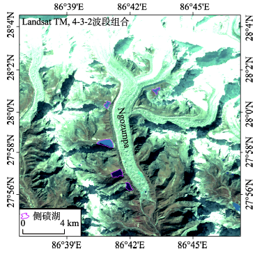
(2)冰川槽谷湖(Glacial valley lake)。大型山谷冰川通过对冰床下切侵蚀和对支沟侧向侵蚀形成两侧陡直而底部宽平的“U”型谷地,在槽谷中汇集冰川融水和大气降水所形成的湖泊可归为冰川槽谷湖。此类冰湖通常规模较大且离现代冰川较远,尽管部分湖泊坝体为古冰碛堆积物,为便于与小冰期以来形成的冰碛湖区分及考虑其对下游地区潜在的危险(是冰湖溃决灾害链中的重要组成部分),可将这些湖泊归为冰川槽谷湖。根据阿克库勒湖距其补给冰川(喀纳斯冰川)的距离和冰川规模(图2),建议在判识冰川槽谷湖时,首先要考虑其形态为长条状,其次湖泊上游应有面积较大的现代冰川(>20 km2),再次应考虑现代冰川融水对湖泊的补给作用,可以湖泊距流域内面积最大冰川末端的距离小于15 km为参考,以与其他构造湖相区分。
(3)其他冰川侵蚀湖。难以通过地貌形态辨识且不属于下列其他冰湖类型的冰川湖泊可归为此类。
冰碛阻塞湖(简称冰碛湖)是指受冰碛垄阻塞而在冰碛垄与冰川之间形成的湖泊。按其所在位置可分为终碛阻塞湖、侧碛阻塞湖和冰碛垄热融湖3个子类型。
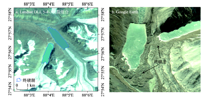
(1)终碛阻塞湖(简称终碛湖,End moraine-dammed lake)是指在冰川消融退缩过程中,在冰碛物构成的终碛垄与冰川末端之间渚水形成的湖泊,这类冰湖是中国喜马拉雅山地区和念青唐古拉山地区造成冰湖溃决洪水或泥石流灾害的主要类型。终碛湖多与冰川末端相连或与冰川末端间的距离甚小,在遥感影像上易于判别(图3a)。在Google Earth软件中,通常可见清晰的呈隆起状的冰川终碛垄(图3b)。在一些冰川末端下游通常存在若干条终碛垄并在其间形成湖泊,因其形成主因是冰川作用且湖水主要靠冰川融水补给,故可将这些湖泊划归为终碛阻塞湖。通过对喜马拉雅山地区此种类型湖泊间距离量测,最上游终碛阻塞湖与最下游终碛阻塞湖的距离不超过2.0 km,即距最上游终碛湖2.0 km以外且位于其下游的湖泊不再判识为终碛阻塞湖。
(2)侧碛阻塞湖(简称侧碛湖,Lateral moraine-dammed lake)是指受冰川侧碛垄阻挡积水而形成的湖泊。侧碛湖通常位于规模较大的山谷冰川侧碛垄两侧,由主谷冰川侧碛垄阻塞支谷冰川融水而形成。如在珠穆朗玛峰南侧最大的冰川——格重巴(Ngozumpa)冰川侧碛垄两侧就发育有5个侧碛阻塞湖(图4),其中第3高佑湖(Gokyo Lake)是面积最大的侧碛湖,为0.59 km2。
(3)冰碛垄热融湖(Moraine thaw lake)。在一些冰川终碛垄或侧碛垄上通常也分布着数量众多但规模较小的湖泊(图5),因其距冰碛湖很近,一些学者将其归属为冰碛湖,亦有学者称之为冰前热融湖[45]。此类湖泊以冻融作用为主要营力,如埋藏于冰碛中的死冰受热融化后引起地表沉陷而形成积水洼地,尽管其本身现在并不接纳冰川融水,但因死冰消融而形成,故可列入冰湖范畴。需要指出的是,在石冰川和冻土区广泛分布的热融湖不属于冰碛垄热融湖,在冰湖编目工作或冰湖变化研究中应予以剔除。
图5 冰碛垄热融湖(b图中黄色线条内蓝绿色水体)
Fig. 5 Moraine thaw lake (water body in blue-green color within the yellow-color polygon in sub-figure b)
无论是冰川前进或跃动堵塞主河谷蓄水成湖,还是由于支冰川快速退缩与主冰川分离,在支冰川末端空出的冰蚀谷地中由主冰川阻塞而形成的湖泊,都是以冰川冰作为坝体的,因此可称此类冰川湖为冰川阻塞湖(简称冰坝湖)。根据冰川阻塞湖的形成原因可分为冰川前进阻塞湖(Advancing glacier-blocked lake)和其他冰川阻塞湖(Glacier-blocked lake),前者主要出现在中国境内的叶尔羌河流域(如克亚吉尔特索湖),后者典型代表是库玛拉克河流域的麦茨巴赫湖(属吉尔吉斯斯坦),但在中国羌塘高原发现也存在此类冰川阻塞湖(图6),之前尚未见报道。对于冰川前进阻塞湖而言,冰坝冰体受低海拔气温较高和湖水侵蚀作用,生存期往往较短(几个月至一年);对于其他冰川阻塞湖,其演变呈现不同特征,如麦茨巴赫湖溃决后因排水通道闭合蓄水能够再次成湖,具有一定的周期性,但在青藏高原内部此类冰湖通常较稳定。
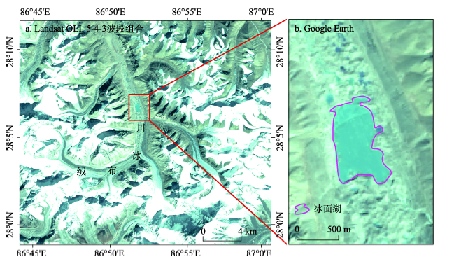
冰面湖是指位于冰川表面的湖泊,因冰川表面差异消融形成的临时性积水洼地。冰面湖多出现在规模较大的表碛覆盖型冰川消融区表面,如在珠穆朗玛峰北侧绒布冰川消融区就发育有数量众多的冰面湖(图7),其中面积最大湖泊约0.47 km2(2016年)。在天山托木尔峰地区,诸如托木尔冰川、土格别里齐冰川、科契卡尔巴西冰川、琼台兰冰川等表碛覆盖型冰川表面亦有大量冰面湖发育。当冰面湖与冰内排水系统连通时,湖水可以快速排出,因此冰面湖通常年内、年际变化都较大。鉴于目前研究常用的Landsat系列卫星遥感影像空间分辨率小、冰面湖变化迅速、面积较大的冰面湖是终碛湖的雏形等,建议以面积≥ 0.02 km2的冰面湖作为冰湖编目对象。冰面湖与冰碛垄热融湖的区别主要在于二者所处部位不同,前者位于冰川表面,后者则位于冰碛垄上。
冰下(内)湖是指在冰川内部或冰床上发育形成的湖泊。研究发现在南极冰盖下存在140个以上的冰下湖[47],最大的湖泊即Vostok Lake(沃斯托克湖,又名东方湖)。对于山地冰川而言,目前尚未有此类冰湖见诸报端,但在中国藏东南海洋性冰川分布区,由于冰下水系通道发育,小规模的冰下(内)湖有可能存在,但需借助冰雷达等仪器,仅依靠卫星遥感影像难以判识。为保证冰湖分类体系的完整性,本文将冰下(内)湖作为冰湖的一种类型列出,但在基于卫星遥感影像开展冰湖相关研究时可将其剔除。
除上述5种类型冰川湖泊外,在冰川作用区,由于山体滑坡、基岩垮塌、泥石流或雪崩阻塞冰川融水所形成的湖泊统一归属为其他冰川湖。此类湖泊为堰塞湖,通常对下游居民点和道路、水电站等基础设施存在巨大潜在危害,因此在冰湖编目中应予以考虑。对于此类冰湖的判识依据一是其坝体,除借助高分辨率遥感影像外,堰塞湖的形成多与地震、泥石流等活动相关[48],在此时间节点前后湖泊规模有明显变化,如2013年7月5日西藏嘉黎县然则日阿错溃决泥石流堵塞衣布沟和罗琼沟形成的两处堰塞湖[9];二是距现代冰川的距离,建议以距冰川末端10 km为参考[43-44]。
冰湖作为冰冻圈科学领域的重要研究对象,其形成与演化不仅与气候变化、冰川运动息息相关,而且是山地灾害链中的重要环节,受到学术界和政府相关部门的广泛关注。本文从概念的内涵和外延角度对冰湖定义进行了讨论,指出现有冰湖定义主要是基于冰川作用和冰川融水补给两种视角,但概念中时空信息的模糊化造成在冰湖编目或冰湖变化研究中实际操作性较差,即某一湖泊是否为冰川湖泊难以确定。在理论上由冰川作用形成的湖泊都可以称为冰川湖泊,即末次冰期冰盛期以来在受冰川侵蚀作用形成的洼地中积水而形成的天然水体。然而,末次冰期冰盛期冰川覆盖范围的难以界定或第四纪冰川学知识的欠缺,研究人员对于湖泊类型的判定依然存在不同的认识,即基于理论上的冰川湖泊定义可操作性较差。由于已有冰湖的研究关注点在于冰川及其融水对冰湖的作用,因此从面向冰湖编目和冰湖研究角度,可将冰湖定义为“以现代冰川融水为主要补给源或在冰碛垄洼地内积水形成的天然水体”。按照冰湖形成机理可分为冰川侵蚀湖、冰碛阻塞湖、冰川阻塞湖、冰面湖、冰下(内)湖和其他冰川湖6大类,其中前3种类型按冰湖所在的空间位置或地貌形态又可次分为冰斗湖、冰川槽谷湖、其他冰川侵蚀湖、终碛阻塞湖、侧碛阻塞湖、冰碛垄热融湖、冰川前进阻塞湖和其他冰川阻塞湖8个亚类。
尽管本文尝试从遥感影像识别角度给出不同类型冰湖的判别依据,并强调现代冰川的存在是确认其是否为冰湖的首要依据,但在实际研究工作中依然存在一些问题,如在某一时期(如中国第一次冰川编目)某流域存在冰川且其下游分布有冰川湖泊,而在另一时期(如21世纪之后)该冰川消失则该湖泊是否为冰川湖泊?因此,研究人员除应明确研究时间基准外,还应保证研究对象的前后一致性。此外,本文对一些冰湖类型的定量判识指标(如湖泊距冰川的距离、湖泊上游冰川面积的大小)来自对典型冰湖的研究,其代表性如何亦需要更深入的工作来验证。
The authors have declared that no competing interests exist.
| [1] |
China's lakes at present: Number, area and spatial distribution.
以11004景/幅CBERSCCD和LandsatTM/ETM卫星遥感影像数据为基础,参照GoogleEarth影像及其他文献资料,在6843幅1:10万和1:5万地形图(DRG)、1:25万地形图部分图层数据(DLG)的支持下,制定了湖泊边界判译原则,经过遥感判译、野外考察、室内校正、专家咨询、数据校正和成果确定等技术环节,确定全国目前共有1.0km2以上的自然湖泊2693个,分布在28个省(自治区、直辖市),总面积81414.6km2,约占全国国土面积的0.9%.近30年来,全国新生和新发现面积大于1.0km2的湖泊分别共有60个和131个,原面积大于1.0km2的湖泊消失243个.
中国湖泊的数量、面积与空间分布 .
以11004景/幅CBERSCCD和LandsatTM/ETM卫星遥感影像数据为基础,参照GoogleEarth影像及其他文献资料,在6843幅1:10万和1:5万地形图(DRG)、1:25万地形图部分图层数据(DLG)的支持下,制定了湖泊边界判译原则,经过遥感判译、野外考察、室内校正、专家咨询、数据校正和成果确定等技术环节,确定全国目前共有1.0km2以上的自然湖泊2693个,分布在28个省(自治区、直辖市),总面积81414.6km2,约占全国国土面积的0.9%.近30年来,全国新生和新发现面积大于1.0km2的湖泊分别共有60个和131个,原面积大于1.0km2的湖泊消失243个.
|
| [2] |
The relationship between air temperature fluctuation and glacial lake outburst floods in Tibet, China. https://doi.org/10.1016/j.quaint.2013.11.023 URL [本文引用: 1] 摘要
In recent years, disasters caused by Glacial Lake Outburst Floods (GLOFs) have taken place more frequently in Tibet than previously and have been the cause of considerable losses. Temperature fluctuations are believed a major influencing factor of GLOFs. However, if or how much climatic change influences GLOFs is a question that remains to be answered. In this paper, using 24 GLOFs related to 19 glacial lakes and temperature data from 14 meteorological stations, we explored the relationships between temperature variations on different temporal scales (annual, monthly, and daily) and GLOFs. There were three active periods for GLOFs in the 1960s, 1980s and 2000s in Tibet, when 16 of 24 GLOFs took place. All the studied GLOFs occurred in the ablation months (from May and September, and especially in July and August) and on ablation days with a monthly average temperature and daily average temperature that were both greater than 0聽掳C. Based on the analysis of monthly and daily temperature, GLOFs depend on the coupled influence of ablation temperature and accumulation temperature; even the accumulation temperature may be important. Based on this, temperature increments were defined, representing the change from accumulation to ablation temperature with a significant impact on GLOFs. There is an altitude effect on GLOFs, in that lakes at lower altitude generally burst earlier, whereas those at a higher altitude burst later. The monthly and daily increments increase according to a similar power-law form with elevation.
|
| [3] |
Spatial-temporal variations of lake area in Hoh Xil region in the past 40 years. 近40年可可西里地区湖泊时空变化特征 . |
| [4] |
Climatic implications on variations of lakes in the cold and arid regions of China during the recent 50 years. https://doi.org/10.3969/j.issn.1000-0240.2006.05.001 URL 摘要
The study objects in this work are lakes in the Tibetan Plateau,Inner Mongolia and Xinjiang regions.Dynamic relations between lake and climate change are revealed through analyzing the variations of typical lakes and climate change in each lake regions.The relationship between variations in area of lake and climate change in phase is analyzed in a regional scale.It is found that the lakes locating in the cold and the arid regions of China have highly sensitivity to the climate change.The lakes in the Inner Mongolia lake region are affected mainly by precipitation in view of climate.As a whole,precipitation has more noticeable impact on the lakes in the Xinjiang lake region.But Air temperature also has definite impact due to glaciers in the region.Precipitation and air temperature have the different effects on different lakes on the Tibetan Plateau.The relationship between lake and climate change is even more complicated in a regional scale.The lakes,as a whole,tend to shrink under the conditions of precipitation increasing and air temperature rising on the Tibetan Plateau.
近50a中国寒区与旱区湖泊变化的气候因素分析 .https://doi.org/10.3969/j.issn.1000-0240.2006.05.001 URL 摘要
The study objects in this work are lakes in the Tibetan Plateau,Inner Mongolia and Xinjiang regions.Dynamic relations between lake and climate change are revealed through analyzing the variations of typical lakes and climate change in each lake regions.The relationship between variations in area of lake and climate change in phase is analyzed in a regional scale.It is found that the lakes locating in the cold and the arid regions of China have highly sensitivity to the climate change.The lakes in the Inner Mongolia lake region are affected mainly by precipitation in view of climate.As a whole,precipitation has more noticeable impact on the lakes in the Xinjiang lake region.But Air temperature also has definite impact due to glaciers in the region.Precipitation and air temperature have the different effects on different lakes on the Tibetan Plateau.The relationship between lake and climate change is even more complicated in a regional scale.The lakes,as a whole,tend to shrink under the conditions of precipitation increasing and air temperature rising on the Tibetan Plateau.
|
| [5] |
Peak discharge estimates of glacial-lake outburst floods and “normal” climatic floods in the Mount Everest region, Nepal. https://doi.org/10.1016/S0169-555X(01)00037-X URL [本文引用: 1] 摘要
Glacial-lake outburst floods (GLOFs) in the Mount Everest region of Nepal on 3 September 1977 and 4 August 1985 dramatically modified channels and valleys in the region by eroding, transporting, and depositing large quantities of sediment for tens of kilometers along their flood routes. Prior to this research, the GLOF discharges had not been determined and the hydrology of 鈥渘ormal鈥 climatic floods (SHFFs: seasonal high flow floods) was not known. A one-dimensional step-backwater flow model was utilized, in conjunction with paleostage indicators, to estimate the peak discharges of the GLOFs and SHFFs and to reconstruct the hydrology and hydraulic conditions of the GLOFs at 10 reaches and SHFFs at 18 reaches. The most reliable GLOF and SHFF peak discharge estimates were upstream from constrictions where there was critical-depth control. The peak discharge of the 1977 GLOF at 8.6 km from the breached moraine was approximately 1900 m 3/s. At 7.1 km downstream from the breached moraine, the 1985 GLOF discharge was estimated at 2350 m 3/s. At 27 km downstream from the breached moraine, the 1985 GLOF attenuated to an estimated discharge of 1375 m 3/s. The peak discharges of SHFFs ranged from 7 to 205 m 3/s and were positively correlated with increasing drainage area. The GLOF discharges were 7 to 60 times greater than the SHFF discharges with the greatest ratios occurring near the breached moraines. The downstream decline in the ratio between the GLOF discharge and SHFF discharge is the result of the downstream attenuation of the GLOF and the increased discharge of the SHFF because of increased contributing drainage area and the increased effects of monsoonal precipitation at lower elevations.
|
| [6] |
|
| [7] |
Glacier lake investigation and inventory in the Chinese Himalayas based on the remote sensing data. https://doi.org/10.11821/xb201001004 URL [本文引用: 4] 摘要
随着我国新一期冰川编目工作的进行和深入,开展全国范围内的冰湖编目已提上日程。基于278幅大比例尺地形图(20世纪70-80年代)、38景ASTER影像和7景TM(2004-2008年),通过建立冰湖编目规范,对我国喜马拉雅山区冰湖进行遥感调查与编目,分析近30年来冰湖的分布及其变化特征。结果显示:(1)本区2004-2008年间共有冰湖1680个,总面积215.28km^2 (2)近30年来我国喜马拉雅山地区冰湖变化总体呈现数量减少、面积增大的趋势,数量减少了4% 总面积增大了29% (3)近30年来有294个冰湖消失,新增加224个冰湖,变化最快的为冰碛湖,在消失的冰湖中66%为冰碛湖,新增加的冰湖中88%为冰碛湖。进一步分析表明冰湖面积增加是气候变暖、冰川退缩和冰川加速消融的产物。
我国喜马拉雅山区冰湖遥感调查与编目 .https://doi.org/10.11821/xb201001004 URL [本文引用: 4] 摘要
随着我国新一期冰川编目工作的进行和深入,开展全国范围内的冰湖编目已提上日程。基于278幅大比例尺地形图(20世纪70-80年代)、38景ASTER影像和7景TM(2004-2008年),通过建立冰湖编目规范,对我国喜马拉雅山区冰湖进行遥感调查与编目,分析近30年来冰湖的分布及其变化特征。结果显示:(1)本区2004-2008年间共有冰湖1680个,总面积215.28km^2 (2)近30年来我国喜马拉雅山地区冰湖变化总体呈现数量减少、面积增大的趋势,数量减少了4% 总面积增大了29% (3)近30年来有294个冰湖消失,新增加224个冰湖,变化最快的为冰碛湖,在消失的冰湖中66%为冰碛湖,新增加的冰湖中88%为冰碛湖。进一步分析表明冰湖面积增加是气候变暖、冰川退缩和冰川加速消融的产物。
|
| [8] |
Risk analysis of mountain hazards in Tibetan Plateau under global warming. https://doi.org/10.3969/j.issn.1673-1719.2014.02.004 URL [本文引用: 1] 摘要
Based on the mountain hazards events in the Tibetan Plateau during the period of 1930-2010, the impacts of global warming on mountain hazards in alpine area were analyzed. Under the circumstance of global warming, glacial lake outburst disaster and glacial debris tended to be more active. Disaster chain was apparent and showed a tendency of spatial and temporal extension, associated with the increasing occurrences of catastrophe. It showed a climatic characteristics of rain and heat occurring in the same period, which constituted a favorable combination for the formation of glacial debris in the southeast region of Tibet. Building distribution in debris-flow risky areas of Sangdeng Gully and Ganong Gully with an area of 0.014 km in 1988 extended to 1.004 kmin 2012, economic activity overlapped with the high risk areas coupled with the increasing disaster risk due to climate change, and thus disaster risk in mountain regions significantly increased. The above results provide evidence about the impact of climate change on mountain hazards in Tibetan Plateau and preliminarily describe characteristics of the impact, which will help to reduce mountain hazards and further understand the corresponding impact mechanism.
气候变暖背景下青藏高原山地灾害及其风险分析 .https://doi.org/10.3969/j.issn.1673-1719.2014.02.004 URL [本文引用: 1] 摘要
Based on the mountain hazards events in the Tibetan Plateau during the period of 1930-2010, the impacts of global warming on mountain hazards in alpine area were analyzed. Under the circumstance of global warming, glacial lake outburst disaster and glacial debris tended to be more active. Disaster chain was apparent and showed a tendency of spatial and temporal extension, associated with the increasing occurrences of catastrophe. It showed a climatic characteristics of rain and heat occurring in the same period, which constituted a favorable combination for the formation of glacial debris in the southeast region of Tibet. Building distribution in debris-flow risky areas of Sangdeng Gully and Ganong Gully with an area of 0.014 km in 1988 extended to 1.004 kmin 2012, economic activity overlapped with the high risk areas coupled with the increasing disaster risk due to climate change, and thus disaster risk in mountain regions significantly increased. The above results provide evidence about the impact of climate change on mountain hazards in Tibetan Plateau and preliminarily describe characteristics of the impact, which will help to reduce mountain hazards and further understand the corresponding impact mechanism.
|
| [9] |
The cause and potential hazard of glacial lake outburst flood occurred on July 5, 2013 in Jiali county, Tibet. 2013年西藏嘉黎县“7.5”冰湖溃决洪水成因及潜在危害 . |
| [10] |
Study on the glacial lake outburst flood events in Tibet since the 20th century. 20世纪以来西藏冰湖溃决灾害事件梳理 . |
| [11] |
A review of catastrophic drainage of moraine-dammed lakes in British Columbia. https://doi.org/10.1016/S0277-3791(00)00090-1 URL [本文引用: 1] 摘要
Moraine-dammed lakes are common in the high mountains of British Columbia. Most of these lakes formed when valley and cirque glaciers retreated from advanced positions achieved during the Little Ice Age. Many moraine dams in British Columbia are susceptible to failure because they are steep-sided, have relatively low width-to-height ratios, comprise loose, poorly sorted sediment, and may contain ice cores or interstitial ice. In addition, the lakes commonly are bordered by steep slopes that are prone to snow and ice avalanches and rockfalls. Moraine dams generally fail by overtopping and incision. The triggering event may be a heavy rainstorm, or an avalanche or rockfall that generates waves that overtop the dam. The dam can also be overtopped by an influx of water caused by sudden drainage of an upstream ice-dammed lake (j枚kulhlaup). Melting of moraine ice cores and piping are other possible failure mechanisms. Failures of moraine dams in British Columbia produce destructive floods orders of magnitude larger than normal streamflows. Most outburst floods are characterized by an exponential increase in discharge, followed by an abrupt drop to background levels when the water supply is exhausted. Peak discharges are controlled by dam characteristics, the volume of water in the reservoir, failure mechanisms, and downstream topography and sediment availability. For the same potential energy at the dam site, floods from moraine-dammed lakes have higher peak discharges than floods from glacier-dammed lakes. The floodwaters may mobilize large amounts of sediment as they travel down steep valleys, producing highly mobile debris flows. Such flows have larger discharges and greater destructive impact than the floods from which they form. Moraine dam failures in British Columbia and elsewhere are most frequent following extended periods of cool climate when large lateral and end moraines are built. A period of protracted warming is required to trap lakes behind moraines and create conditions that lead to dam failure. This sequence of events occurred only a few times during the Holocene Epoch, most notably during the last several centuries. Glaciers built large moraines during the Little Ice Age, mainly during the 1700s and 1800s, and lakes formed behind these moraines when climate warmed in the 1900s. Twentieth-century climate warming is also responsible for recent moraine dam failures in mountains throughout the world. Warming from the late 1800s until about 1940 and again from 1965 to today destabilized moraine dams with interstitial or core ice. The warming also forced glaciers to retreat, prompting ice avalanches, landslides, and j枚kulhlaups that have destroyed some moraine dams.
|
| [12] |
Costa J E. Geologic and hydrologic hazards in glacierized basins in North America resulting from 19th and 20th century global warming. https://doi.org/10.1007/BF00605437 URL [本文引用: 1] 摘要
Alpine glacier retreat resulting from global warming since the close of the Little Ice Age in the 19th and 20th centuries has increased the risk and incidence of some geologic and hydrologic hazards in mountainous alpine regions of North America. Abundant loose debris in recently deglaciated areas at the toe of alpine glaciers provides a ready source of sediment during rainstorms or outburst floods. This sediment can cause debris flows and sedimentation problems in downstream areas. Moraines built during the Little Ice Age can trap and store large volumes of water. These natural dams have no controlled outlets and can fail without warning. Many glacier-dammed lakes have grown in size, while ice dams have shrunk, resulting in greater risks of ice-dam failure. The retreat and thinning of glacier ice has left oversteepened, unstable valley walls and has led to increased incidence of rock and debris avalanches.
|
| [13] |
Living and dying with glaciers: people's historical vulnerability to avalanches and outburst floods in Peru. https://doi.org/10.1016/j.gloplacha.2004.10.007 URL [本文引用: 1] 摘要
Human populations worldwide are vulnerable to natural disasters. Certain conditions—such as geographical location or people's income level—can affect the degree to which natural disasters impact people's homes and livelihoods. This paper suggests that vulnerability to natural disasters increases when local people, scientists, and policymakers do not communicate and trust each other. Additionally, a breakdown in interaction and confidence among these groups can disrupt the implementation of sound science or well-intentioned policies. This case study analyzes how local people, scientists, and government officials responded to glacier hazards in Peru's Cordillera Blanca mountain range. Cordillera Blanca glacier retreat since the late-19th century has triggered some of the world's most deadly avalanches and glacial lake outburst floods. Although a Peruvian glaciology and lakes security office has “controlled” 35 Cordillera Blanca glacial lakes, 30 glacier disasters have killed nearly 30,000 people in this region since 1941. A lack of local faith in government officials and scientists as well as the State's failure to follow scientists' warnings about potential disasters have endangered or led to the death of thousands of local residents, many of which remain living in hazard zones today.
|
| [14] |
Subglacial lakes and jökulhlaups in Iceland. https://doi.org/10.1016/S0921-8181(02)00130-3 URL [本文引用: 1] 摘要
Active volcanoes and hydrothermal systems underlie ice caps in Iceland. Glacier–volcano interactions produce meltwater that either drains toward the glacier margin or accumulates in subglacial lakes. Accumulated meltwater drains periodically in j02kulhlaups from the subglacial lakes and occasionally during volcanic eruptions. The release of meltwater from glacial lakes can take place in two different mechanisms. Drainage can begin at pressures lower than the ice overburden in conduits that expand slowly due to melting of the ice walls by frictional and sensible heat in the water. Alternatively, the lake level rises until the ice dam is lifted and water pressure in excess of the ice overburden opens the waterways; the glacier is lifted along the flowpath to make space for the water. In this case, discharge rises faster than can be accommodated by melting of the conduits. Normally j02kulhlaups do not lead to glacier surges but eruptions in ice-capped stratovolcanoes have caused rapid and extensive glacier sliding. J02kulhlaups from subglacial lakes may transport on the order of 10 7 tons of sediment per event but during violent volcanic eruptions, the sediment load has been 10 8 tons.
|
| [15] |
Remote sensing based assessment of hazards from glacier lake outbursts: A case study in the Swiss Alps. |
| [16] |
Spatiotemporal patterns of high-mountain lakes and related hazards in western Austria. https://doi.org/10.1016/j.geomorph.2015.06.032 URL [本文引用: 1] 摘要
611024 lakes were detected, classified and described by several characteristics.61The evolution and outburst susceptibility of selected young lakes were investigated in more detail.61A system of phases of lake evolution and lake–glacier-relationships was proposed for bedrock-dammed lakes.61Identified evolutionary patterns were synthesized in a general evolutionary scheme.
|
| [17] |
Recent glacier retreat in the Caucasus Mountains, Russia, and associated increase in supraglacial debris cover and supra-/proglacial lake development. https://doi.org/10.3189/172756407782871468 URL [本文引用: 1] 摘要
This paper reports changes in supraglacial debris cover and supra-/proglacial lake development associated with recent glacier retreat (1985-2000) in the central Caucasus Mountains, Russia. Satellite imagery (Landsat TM and ETM+) was used to map the surface area and supraglacial debris cover on six neighbouring glaciers in the Adylsu valley through a process of manual digitizing on a false-colour composite of bands 5, 4, 3 (red, green, blue). The distribution and surface area of supraglacial and proglacial lakes was digitized for a larger area, which extended to the whole Landsat scene. We also compare our satellite interpretations to field observations in the Adylsu valley. Supraglacial debris cover ranges from 25% on individual glaciers, but glacier retreat between 1985 and 2000 resulted in a 3-6% increase in the proportion of each glacier covered by debris. The only exception to this trend was a very small glacier where debris cover did not change significantly and remote mapping proved more difficult. The increase in debris cover is characterized by a progressive upglacier migration, which we suggest is being driven by focused ablation (and therefore glacier thinning) at the up-glacier limit of the debris cover, resulting in the progressive exposure of englacial debris. Glacier retreat has also been accompanied by an increase in the number of proglacial and supraglacial lakes in our study area, from 16 in 1985 to 24 in 2000, representing a 57% increase in their cumulative surface area. These lakes appear to be impounded by relatively recently lateral and terminal moraines and by debris deposits on the surface of the glacier. The changes in glacier surface characteristics reported here are likely to exert a profound influence on glacier mass balance and their future response to climate change. They may also increase the likelihood of glacier-related hazards (lake outbursts, debris slides), and future monitoring is recommended.
|
| [18] |
Changes of Petrov Glacier and its proglacial lake in the Akshiirak massif, central Tien Shan, since 1977. https://doi.org/10.3189/2012JoG11J085 URL [本文引用: 1] 摘要
A combination of remotely sensed data, field mapping, bathymetric survey and geophysical soundings is used to describe the recent changes in the terminal area of Petrov glacier, the largest glacier in the Akshiirak massif, central Tien Shan. According to our results, three periods of accelerated glacier retreat (1977–80, 1990–95 and 2008–09) can be distinguished since 1977. The largest recession occurred in 1990–95 when the glacier retreated by 54 8 m a. Accelerated glacier retreat affected the enlargement rate of Petrov lake, which increased by 0.04–0.1 kmaand by 1.3–2.2 10main the last three decades. Since 1995, the mean annual retreat rate of the lake-calving northern glacier section has been up to three times higher than the retreat rate of the land-terminating southern section. The calving flux ranged from 2.5 to 4.6 10main 2003–09, resulting in a total glacier mass loss of (17.7 0.4) 10m. The calving terminus of Petrov glacier was >65 m thick in 2009 according to ground-penetrating radar measurements.
|
| [19] |
Outburst flood hazard: Case studies from the Tien-Shan Mountains, Kyrgyzstan. Limnologica - Ecology and Management of
|
| [20] |
Wide expansion of glacial lakes in Tianshan Mountains during 1990-2010. 近20年天山地区冰湖变化特征 . |
| [21] |
Response of glacial-lake outburst floods to climate change in the Yarkant River basin on northern slope of Karakoram Mountains, China. https://doi.org/10.1016/j.quaint.2010.01.003 URL 摘要
Based on the glacial flood events and climate change in the Yarkant River basin during the past 50 years, the study investigated the long-term change of temperature and precipitation, the characteristics of glacial floods, the origin of sudden flood release, the suggested flood mechanism of glacial lakes and the relationship between glacial floods and climate change. Results showed that there was an obvious increase in the temperature of the basin since 1987. Specifically in the mountainous area, the significantly increasing temperature in the summer and autumn seasons accelerated the melting rate of glaciers and caused glacial-lake burst. Sudden flood release occurred frequently. The frequency of glacial-lake outburst floods was 0.4 times/a during the period 1959–1986 and increased to 0.7 times/a during 1997–2006. Peak discharge also increased. There were seven floods with peak discharge over 4000 m 3/s from 1959–2006, and three occurred after 1997. The increasing frequency and magnitude of glacial outburst floods mirrored the effect of climate warming on glaciers.
|
| [22] |
Heterogeneity of glacial lake expansion and its contrasting signals with climate change in Tarim Basin, Central Asia. https://doi.org/10.1007/s12665-016-5498-4 URL [本文引用: 1] 摘要
On the basis of Landsat TM/ETM +/OLI imagery in the years 1990, 2000 and 2013, changes of lake area were detected and its contrasting signals with climate change are addressed for Tarim Basin in Central Asia. During the past 2302years, the lake area has expanded at an average rate of 0.6702%/a, with the fastest rates in Altun Shan and Tian Shan mountains and slower rates in the Karakoram and Pamir, which indicates spatially heterogeneous warmer and wetter climatic signals in the basin. Examining decades, the average expansion rate of lake area (0.9802%/a) over 2000–2013 was about four times that (0.2302%/a) of 1990–2000, indicating accelerated warmer–wetter trends around the transition year 2000 in the mountain areas. Discrepant area expansion of different types of glacial lake implies contrasting signals of climate change in the Tarim Basin. Fewer direct climatic signals can be inferred from changes of supraglacial lakes. Ice-contacting lakes characterized by the fastest expansion rate (3.3502%/a) depict accelerated glacier shrinkage caused by climate warming. Non-glacier-fed lakes expansion at the rate of 0.5702%/a reflect an apparent increase of precipitation in the mountains of Tarim Basin.
|
| [23] |
Performance of ASTER and SRTM DEMs, and their potential for assessing glacial lakes in the Lunana region, Bhutan Himalaya. https://doi.org/10.3189/002214308784886162 URL [本文引用: 1] 摘要
To assess the potential volume of a glacial lake outburst flood (GLOF) more precisely than in previous studies, we analyze ground survey data and remote-sensing digital elevation models (DEMs) around glacial lakes in the Lunana region, Bhutan. Based on a DEM generated from differential GPS ground surveys, we first evaluate the relative accuracies of DEMs produced by the Advanced Spaceborne Thermal Emission and Reflection Radiometer (ASTER) and the Shuttle Radar Topography Mission (SRTM). Root-mean-square errors of the altitudinal difference between these DEMs and ground survey data were 11.0 m for ASTER and 11.3 m for SRTM. These errors are similar to those of previous studies. We show that a topographical classification allows a better estimate of elevation on lakes/ponds, riverbeds and glaciers due to their flat surfaces, while the relative accuracy is worse over moraines and hill slopes due to their narrow ridges and steep slopes. Using the optical satellite images and the ground survey data, we re-evaluate the GLOF volume in 1994 as (17.2卤5.3) 脳 10m. We show GLOF-related information such as distance, altitudinal difference and gradient at possible outburst points where the lake level is higher than the neighboring riverbed and/or glacial lake.
|
| [24] |
Heterogeneous glacial lake changes and links of lake expansions to the rapid thinning of adjacent glacier termini in the Himalayas. https://doi.org/10.1016/j.geomorph.2016.12.002 URL 摘要
Glacier mass loss in the Himalayas has far-reaching implications for the alteration of regional hydrologic regimes, an increased risk of glacial lake outburst, downstream water resource abundance, and contributions to sea level rise. However, the mass losses of Himalayan glaciers are not well understood towing to the scarcity of observations and the heterogeneous responses of Himalayan glaciers to climate change and local factors (e.g., glacier surge, interacting with proglacial lakes). In particular, there is a lack of understanding on the unique interactions between moraine-dammed glacial lakes and their effects on debris cover on valley glacier termini. In this study, we examined the temporal evolution of 151 large glacial lakes across the Himalayas and then classified these glacial lakes into three categories: proglacial lakes in contact with full or partial debris-covered glaciers (debris-contact lakes), ice cliff-contact lakes, and non-glacier-contact lakes. The results show that debris-contact lakes experienced a dramatic areal increase of 36.5% over the years 2000 to 2014, while the latter two categories of lakes remained generally stable. The majority of lake expansions occurred at the glacier front without marked lake level rises. This suggests that the rapid expansion of these debris-contact lakes can be largely attributed to the thinning of debris-covered ice as caused by the melting of glacial fronts and the subsequent glacial retreat. We reconstructed the height variations of glacier fronts in contact with 57 different proglacial lakes during the years 2000 to 2014. These reconstructed surface elevation changes of debris-covered, lake-contact glacier fronts reveal significant thinning trends with considerable lowering rates that range from 1.0 to 9.7聽m/y. Our study reveals that a substantial average ice thinning of 3.9聽m/y occurred at the glacier fronts that are in contact with glacial lakes.
|
| [25] |
Automatic extraction of Himalayan glacial lakes with remote sensing. https://doi.org/10.11834/jrs.20110103 URL [本文引用: 1] 摘要
在"全域-局部"分步迭代水体信息提取方法的基础上,通过对水体信息提取指标——水体指数的物理特性的分析实现了算法中全域阈值的自动选择与局部阈值的自适应调整,并结合DEM生成的山体坡度和阴影信息,减少局部迭代过程中对其他地表特征与水体信息的误判。在此基础上,建立一种适合于高山地区冰川湖泊的自动化提取方案。试验采用Landsat数据对喜马拉雅山地区的冰川湖白进行信息提取,结果表明该方法能够快速准确地完成大区域范围内的冰川湖泊制图,并能最大程度地消除高山地区湖泊水体识别中冰川和山体阴影的影响。
喜马拉雅山地区冰湖信息的遥感自动化提取 .https://doi.org/10.11834/jrs.20110103 URL [本文引用: 1] 摘要
在"全域-局部"分步迭代水体信息提取方法的基础上,通过对水体信息提取指标——水体指数的物理特性的分析实现了算法中全域阈值的自动选择与局部阈值的自适应调整,并结合DEM生成的山体坡度和阴影信息,减少局部迭代过程中对其他地表特征与水体信息的误判。在此基础上,建立一种适合于高山地区冰川湖泊的自动化提取方案。试验采用Landsat数据对喜马拉雅山地区的冰川湖白进行信息提取,结果表明该方法能够快速准确地完成大区域范围内的冰川湖泊制图,并能最大程度地消除高山地区湖泊水体识别中冰川和山体阴影的影响。
|
| [26] |
Glacial lake evolution in the southeastern Tibetan Plateau and the cause of rapid expansion of proglacial lakes linked to glacial-hydrogeomorphic processes. https://doi.org/10.1016/j.jhydrol.2016.06.054 URL [本文引用: 3] 摘要
Glacial lakes, as an important component of the cryosphere in the southeastern Tibetan Plateau (SETP) in response to climate change, pose significant threats to the downstream lives and properties of people, engineering construction, and ecological environment via outburst floods, yet we currently have limited knowledge of their distribution, evolution, and the driving mechanism of rapid expansions due to the low accessibility and harsh natural conditions. By integrating optical imagery, satellite altimetry and digital elevation model (DEM), this study presents a regional-scale investigation of glacial lake dynamics across two river basins of the SETP during 1988–2013andfurther explores the glacial-hydrogeomorphic process of rapidly expanding lakes. In total 1278and1396 glacial lakes were inventoried in 1988and2013, respectively. Approximately 92.4% of the lakes in 2013 are not in contact with modern glaciers, and the remaining 7.6% includes 27 (1.9%) debris-contact lakes (in contact with debris-covered ice) and 80 (5.7%) cirque lakes. In categorizing lake variations, we found that debris-contact proglacial lakes experienced much more rapid expansions (6575%) than cirque lakes (657%) and non-glacier-contact lakes (653%). To explore the cause of rapid expansion for these debris-contact lakes, we further investigated the mass balance of parent glaciers and elevation changes in lake surfaces and debris-covered glacier tongues using time-series Landsat images, ICESat altimetry, and DEM. Results reveal that the upstream expansion of debris-contact proglacial lakes was not directly associated with rising water levels but with a geomorphological alternation of upstream lake basins caused by melting-induced debris subsidence at glacier termini. This suggests that the hydrogeomorphic process of glacier thinning and retreat, in comparison with direct glacial meltwater alone, may have played a dominant role in the recent glacial lake expansion observed across the SETP. Our findings assist in understanding the expansion mechanism of debris-contact proglacial lakes, which facilitates early recognition of potential glacial lake hazards in this region.
|
| [27] |
Methods for assessing regional glacial lake variation and hazard in the southeastern Tibetan Plateau: A case study from the Boshula mountain range, China. https://doi.org/10.1007/s12665-012-1589-z URL [本文引用: 2] 摘要
AbstractGlaciers on the Tibetan Plateau are undergoing an accelerating retreat under climatic warming, with the immediate result of glacial lake outburst floods (GLOFs) becoming increasingly frequent. Glacial lakes in the southeast of the Tibetan Plateau are densely distributed. Due to the difficulties associated with field investigations of glacial lakes, including remote locations and harsh weather conditions, methods which combine remote sensing, geographic information systems and hydrodynamic modeling (HEC-RAS) with field investigation were developed to assess regional glacial lake variation and hazard. The methods can be divided into three levels. At the first level, multi-temporal satellite images were used to (1) study the variation of glacial lakes for the whole region during recent decades, as well as (2) qualitatively identify potentially dangerous glacial lakes (PDGLs). The second level is an in-depth evaluation of the degree of danger for selected PDGLs by ground-based surveys, and then verification of the first-level results. At the third level, the one-dimensional (1D) hydrodynamic model HEC-RAS was used to simulate the inundation characteristics of hypothetical outburst of PDGLs. The three levels downscale from the whole study area to individual PDGLs, and thus assess the hazard of glacial lakes progressively. The methods were then applied to a region of southeastern Tibet鈥攖he Boshula mountain range鈥攖o analyze the variation of glacial lakes and assess potential hazards posed by GLOFs. Since these methods employ easily accessible data and instruments, the application in other regions is promising.
|
| [28] |
Analysis of the characteristics of glacial lake variation in the Koshi River basin, the Himalayas based on RS and GIS. https://doi.org/10.7522/j.issn.1000-0240.2015.0063 URL [本文引用: 3] 摘要
受全球气候变暖的影响,冰川退缩,冰湖数量增多和面积增大被认为指示气候变化的重要依据,冰湖面积增大导致其潜在危险性增大.因此,研究冰湖的变化对于气候变化和冰湖灾害研究具有重要意义.基于Landsat TM/ETM+遥感影像采用人工解译的方法,获取了喜马拉雅山地区科西河流域1990年前后、2000年和2010年的冰湖数据,并对冰湖面积〉0.1 km^2且一直存在的199个冰湖的面积和长度变化进行对比分析.结果表明:科西河流域内面积〉0.1 km^2的冰湖的面积呈现增加趋势,1990年冰湖面积为73.59 km^2,2010年冰湖面积增加至86.12 km^2.科西河流域内喜马拉雅山南北坡冰湖变化存在差异,喜马拉雅山北坡变化较大的冰湖主要分布在海拔4 800-5 600 m之间,而南坡变化较大的冰湖主要分布在海拔4 300-5 200 m之间;喜马拉雅山北坡的冰湖有65%的冰湖表现扩张,且扩张冰湖的面积主要是由冰湖在靠近终碛垅的一端基本不发生变化,而仅在靠近冰川一端发生变化贡献的;喜马拉雅山南坡的冰湖有32%的冰湖变化表现扩张,且扩张的冰湖面积主要来自于冰面湖扩张.在科西河流域内,位于喜马拉雅山北坡的冰湖平均变化速度略高于南坡的冰湖平均变化速度.
基于遥感和GIS的喜马拉雅山科西河流域冰湖变化特征分析 .https://doi.org/10.7522/j.issn.1000-0240.2015.0063 URL [本文引用: 3] 摘要
受全球气候变暖的影响,冰川退缩,冰湖数量增多和面积增大被认为指示气候变化的重要依据,冰湖面积增大导致其潜在危险性增大.因此,研究冰湖的变化对于气候变化和冰湖灾害研究具有重要意义.基于Landsat TM/ETM+遥感影像采用人工解译的方法,获取了喜马拉雅山地区科西河流域1990年前后、2000年和2010年的冰湖数据,并对冰湖面积〉0.1 km^2且一直存在的199个冰湖的面积和长度变化进行对比分析.结果表明:科西河流域内面积〉0.1 km^2的冰湖的面积呈现增加趋势,1990年冰湖面积为73.59 km^2,2010年冰湖面积增加至86.12 km^2.科西河流域内喜马拉雅山南北坡冰湖变化存在差异,喜马拉雅山北坡变化较大的冰湖主要分布在海拔4 800-5 600 m之间,而南坡变化较大的冰湖主要分布在海拔4 300-5 200 m之间;喜马拉雅山北坡的冰湖有65%的冰湖表现扩张,且扩张冰湖的面积主要是由冰湖在靠近终碛垅的一端基本不发生变化,而仅在靠近冰川一端发生变化贡献的;喜马拉雅山南坡的冰湖有32%的冰湖变化表现扩张,且扩张的冰湖面积主要来自于冰面湖扩张.在科西河流域内,位于喜马拉雅山北坡的冰湖平均变化速度略高于南坡的冰湖平均变化速度.
|
| [29] |
Changes of glacial lakes in different watersheds of Chinese Himalaya during the last four decades. 近40a来中国喜马拉雅山不同流域冰湖演化特征 . |
| [30] |
Assessing the influence of the Merzbacher Lake outburst floods on discharge using the hydrological model SWIM in the Aksu headwaters, Kyrgyzstan/NW China. |
| [31] |
The response of glacial lakes in the Altay Mountains of China to climate change during 1992-2003. 近20年中国阿尔泰山区冰川湖泊对区域气候变化响应的时空特征 . |
| [32] |
Preliminary study of the Jiemayangzong Glacier and lake variations in the source regions of the Yarlung Zangbo River in 1974-2010.
青藏高原冰川和冰湖是气候变化敏感的指示器.基于1974年的地形图及其生成的DEM数据、1990年和2000年的TM影像、2005年和2010年的ETM+影像、以及2010年和2009年的GPS实测数据,应用3S技术分析了1974—2010年37a来雅鲁藏布江源头杰玛央宗冰川和冰湖的变化特征.结果表明:冰川面积减小了5.02%(21.78km2减小至20.67km2)、冰川末端退缩了768m(速度为21m.a-1);冰湖面积增加了63.7%(0.70km2增加至1.14km2),冰湖体积扩大约9.8×10⁶ m3.普兰县气象站的观测资料表明,近37a来气温呈快速上升趋势,而降雨量明显减少,气候暖干化是杰玛央宗冰川和冰湖变化的主要原因.若该区气候的暖干趋势进一步加剧,必然导致杰玛央宗冰川退缩进一步加剧,冰湖溃决的可能性将会增大.
1974-2010年雅鲁藏布江源头杰玛央宗冰川及冰湖变化初步研究 .
青藏高原冰川和冰湖是气候变化敏感的指示器.基于1974年的地形图及其生成的DEM数据、1990年和2000年的TM影像、2005年和2010年的ETM+影像、以及2010年和2009年的GPS实测数据,应用3S技术分析了1974—2010年37a来雅鲁藏布江源头杰玛央宗冰川和冰湖的变化特征.结果表明:冰川面积减小了5.02%(21.78km2减小至20.67km2)、冰川末端退缩了768m(速度为21m.a-1);冰湖面积增加了63.7%(0.70km2增加至1.14km2),冰湖体积扩大约9.8×10⁶ m3.普兰县气象站的观测资料表明,近37a来气温呈快速上升趋势,而降雨量明显减少,气候暖干化是杰玛央宗冰川和冰湖变化的主要原因.若该区气候的暖干趋势进一步加剧,必然导致杰玛央宗冰川退缩进一步加剧,冰湖溃决的可能性将会增大.
|
| [33] |
Spatialtemporal change of glacial lakes in the Biezhentao Mountain and its response to climate change. 50a来别珍套山冰湖的时空变化及其对气候的响应 . |
| [34] |
Glacial lake mapping and analysis of the potentially dangerous glacial lakes before Nepal 4 25 Earthquake in 2015. https://doi.org/10.7522/j.issn.1000-0240.2016.0064 Magsci [本文引用: 3] 摘要
由于地震灾害的影响,冰湖上游的冰滑坡、冰崩、滑坡、泥石流会进入湖泊,通过冲击波或抬高水位,造成冰川坝或冰碛坝突然垮塌导致冰湖迅速排水而形成洪水或洪水泥石流。首先基于Landsat8遥感影像通过人工目视解译的方法构建尼泊尔2015年4月25日地震震前冰湖数据,为我国和尼泊尔的抗震救灾提供重要的数据支撑。然后利用历史遥感数据解译获取研究区2015年以前的历史冰湖数据,对历史冰湖数据和2015年的冰湖数据进行地理空间分析,计算其面积变化和长度变化。最后结合尼泊尔2015年4月25日地震峰值地面加速度数据通过空间分析识别地震影响区的潜在危险冰湖。研究表明:研究区面积>0.02km<sup>2</sup>的冰湖有1847个,面积263.18km<sup>2</sup>,其中快速变化冰湖87个,位于地震影响区的潜在危险冰湖49个,应重点关注潜在危险冰湖。
尼泊尔4·25地震震前冰湖制图与潜在危险性分析 .https://doi.org/10.7522/j.issn.1000-0240.2016.0064 Magsci [本文引用: 3] 摘要
由于地震灾害的影响,冰湖上游的冰滑坡、冰崩、滑坡、泥石流会进入湖泊,通过冲击波或抬高水位,造成冰川坝或冰碛坝突然垮塌导致冰湖迅速排水而形成洪水或洪水泥石流。首先基于Landsat8遥感影像通过人工目视解译的方法构建尼泊尔2015年4月25日地震震前冰湖数据,为我国和尼泊尔的抗震救灾提供重要的数据支撑。然后利用历史遥感数据解译获取研究区2015年以前的历史冰湖数据,对历史冰湖数据和2015年的冰湖数据进行地理空间分析,计算其面积变化和长度变化。最后结合尼泊尔2015年4月25日地震峰值地面加速度数据通过空间分析识别地震影响区的潜在危险冰湖。研究表明:研究区面积>0.02km<sup>2</sup>的冰湖有1847个,面积263.18km<sup>2</sup>,其中快速变化冰湖87个,位于地震影响区的潜在危险冰湖49个,应重点关注潜在危险冰湖。
|
| [35] |
Remote sensing investigation and influence factor analysis of glacier lake outburst potential in the Himalayas. 喜马拉雅山地区冰川湖溃决灾害隐患遥感调查及影响因素分析 . |
| [36] |
Logistic regression model-based approach for predicting the hazard of glacial lake outburst in Tibet. 基于逻辑回归法的西藏地区冰湖溃决危险性预测模型 . |
| [37] |
Remote sensing based glacial lake inventory in the Hindu Kush-Himalaya region. https://doi.org/10.1109/RSETE.2011.5964557 URL [本文引用: 2] 摘要
Glacial lake inventory is the main method to investigate the glacial lakes in remote area and provides required information for glacier risk management and climate change research. A glacial lake inventory based on Landsat TM/ETM+ images has been carried in Hindu-Kush Himalaya regions, and 20204 glacial lakes with total area of 1955.75 km2 are documented by this inventory. This paper introduced the method and material and discussed the merits and demerits of the method. Landsat based glacial lake inventory is effective method for large scale area, but more detail inventory with high resolution satellite images is necessary for glacier risk management and glacial lake change detection. The distribution characteristics is also analyzed by this paper, obvious regional difference was found by this inventory, the formation and distribution of glacial lake are controlled by terrain, glaciation and conditions. The selection of assessment method and criteria need to consider the regional feature of glacial lakes and their environment.
|
| [38] |
Inventory of Glaciers, Glacial Lakes and Glacial Lake Outburst Floods. Monitoring and Early Warning Systems in the Hindu Kush-Himalayan Region: Nepal.
This publication contains the results of a detailed inventory of glaciers and glacial lakes, and of potential or actual glacial lake outburst flood (GLOF) sites, in the Hindu Kush-Himalayan region in Bhutan. The methods used to identify these glaciers and glacial lakes are described. A brief review of the causes and effects of known GLOF events in Bhutan is presented. GLOF mitigation measures, ...
|
| [39] |
Spatial change detection of glacial lakes in the Koshi River Basin, the Central Himalayas. https://doi.org/10.1007/s12665-014-3338-y Magsci [本文引用: 1] 摘要
Region warming and the resulting ongoing deglaciation have led to the formation of new glacial lakes and expansion of existing glacial lakes. For giving an overview of the distribution and expansion of glacial lakes in the Koshi River Basin (KRB) between the Central China and Nepal Himalayas in the recent 10 years, this paper aimed to analyze and assess recent spatial variability of glacial lake changes in the KRB, Central Himalayas using two inventory data of glacial lake in 2001 and 2010 in Nepal and Landsat TM/ETM+ data for the 1990s, 2000 and 2009 on the Chinese section of the KRB. The datasets show that there are 1,203 glacial lakes with a total area of 118.54 km(2) in the KRB in 2009, in which 599 lakes are mapped in the Nepalese section of the KRB with a total of 25.92 km(2), and 604 lakes in the Chinese section of the KRB with a total area of 92.62 km(2). From 2000 to 2009, the total number of glacial lakes decreased from 1,668 to 1,203 with a reduction of 45.86 % in the KRB, whereas the total lake areas expanded by 10.60 % (i.e. 0.72 km(2)/a), from 111.35 to 118.54 km(2) between 2000, 2001 and 2009, 2010. Especially, 17 lakes are identified as potentially dangerous glacial lakes (PDGLs) by International Centre for Integrated Mountain Development (ICIMOD) on the Nepalese section of the KRB in 2009. In the same period, 23 PDGLs are also identified on the Chinese section of the KRB and the total area increased by 77.46 % (i.e. 0.37 km(2)/a) from 1990 to 2010 and the expansion rate is significantly higher than 39 % (0.19 km(2)/a) of non-PDGLs. Therefore, there is a need for promoting the awareness of the hazard potential of glacier lakes to support proper planning of mitigation and adaptation strategies in this context.
|
| [40] |
|
| [41] |
|
| [42] |
Discuss on the temporal and spatial distribution characteristics and impact factors of the eastern Nyainqentanglha Mountain glacier lakes in Tibet. https://doi.org/10.3969/j.issn.1672-3791.2014.16.023 URL [本文引用: 1] 摘要
冰湖是研究气候变化的重要指标之一,了解冰湖分布和变化的特征, 对认识冰湖与气侯之间关系和研究冰湖溃决泥石流灾害有着重要意义.本文拟利用1976年、1988年.2001年和2013年四个期次冰川、冰湖的遥意解 译结果进行分析,得出1976年至2013年念青唐古拉山东段冰川与冰湖发育分布特征,对念青唐古拉山区东段冰川消融以及气候垂直变化具有一定的指示作 用,同时为冰湖溃决泥石流灾害的预测预警提供依据.
西藏念青唐古拉山东段冰湖的时空分布特征及其影响因素探讨 .https://doi.org/10.3969/j.issn.1672-3791.2014.16.023 URL [本文引用: 1] 摘要
冰湖是研究气候变化的重要指标之一,了解冰湖分布和变化的特征, 对认识冰湖与气侯之间关系和研究冰湖溃决泥石流灾害有着重要意义.本文拟利用1976年、1988年.2001年和2013年四个期次冰川、冰湖的遥意解 译结果进行分析,得出1976年至2013年念青唐古拉山东段冰川与冰湖发育分布特征,对念青唐古拉山区东段冰川消融以及气候垂直变化具有一定的指示作 用,同时为冰湖溃决泥石流灾害的预测预警提供依据.
|
| [43] |
Changes of glacial lakes and implications in Tian Shan, Central Asia, based on remote sensing data from 1990 to 2010. https://doi.org/10.1088/1748-9326/8/4/044052 URL [本文引用: 2] 摘要
Changes of glacial lakes and implications were assessed for the Tian Shan Mountains from 1990 to 2010, based on Landsat Thematic Mapper/Enhanced Thematic Mapper Plus images. The total area of glacial lakes has expanded greatly over the last 20 years, at an average rate of 0.69 ± 0.12 kmaor 0.8 ± 0.1% a. Eastern Tian Shan contributed nearly half that increase (≈0.34 ± 0.03 kma), followed by northern Tian Shan at 0.17 ± 0.03 kma. Both widespread climate warming and glacier shrinking led to glacial lake areal expansion, while small to medium (<0.6 km) lakes responded most sensitively to glacier retreat. The closer the hydrologic connection of lakes to glaciers, the greater the areal expansion rate. An average ≈0.007 ± 0.002 Gt aof glacier meltwater has been temporarily held in lakes over the past two decades. The increasing quantity of melt available for lake formation and growth may simultaneously increase the frequency and damage of glacial lake outburst floods or debris flows in this region. Sixty potentially dangerous glacial lakes are identified, among which 12 have an outburst probability status of ‘high’, 25 ‘medium’ and 23 ‘low’.
|
| [44] |
An inventory of glacial lakes in the Third Pole region and their changes in response to global warming. https://doi.org/10.1016/j.gloplacha.2015.05.013 URL [本文引用: 2] 摘要
61The first glacier lake inventory across the Third Pole was developed.61Glacial lakes were primarily located in Brahmaputra (39%), Indus (28%), and Amu Darya (10%) basins.61Glacier-fed lakes showed faster expansion than non-glacier-fed lakes.61Glacier-melt water may play a dominant source for most glacial lake expansion from 1990–2010.
|
| [45] |
Classification and sedimentary types of glacial lakes in the Halasi River catchment, the Altay Mountains, Xinjiang.
根据1989-1990年两个夏季对新疆阿尔泰山哈纳斯河流域冰川湖泊的野外调查并结合室内分析,对该流域冰川湖泊及其沉积类型进行了分类。按其成因冰川湖泊可分为:冰蚀湖、冰川阻塞湖、冰碴湖、冰川热融湖、以及复合成因的冰川湖泊;按补给类型,冰川湖泊还可以分为冰水湖和非冰水湖泊;冰川湖泊除了受到一般湖泊所具有的波浪作用、地表径流作用、块体运动、坡面水流作用以外,还存在冻胀作用、冰川作用和热力作用等。主要沉积类型有:湖滩沉积、浅水沉积、静水沉积和冰川三角洲沉积。
新疆阿尔泰山哈纳斯河流域冰川湖泊的分类与沉积类型 .
根据1989-1990年两个夏季对新疆阿尔泰山哈纳斯河流域冰川湖泊的野外调查并结合室内分析,对该流域冰川湖泊及其沉积类型进行了分类。按其成因冰川湖泊可分为:冰蚀湖、冰川阻塞湖、冰碴湖、冰川热融湖、以及复合成因的冰川湖泊;按补给类型,冰川湖泊还可以分为冰水湖和非冰水湖泊;冰川湖泊除了受到一般湖泊所具有的波浪作用、地表径流作用、块体运动、坡面水流作用以外,还存在冻胀作用、冰川作用和热力作用等。主要沉积类型有:湖滩沉积、浅水沉积、静水沉积和冰川三角洲沉积。
|
| [46] |
|
| [47] |
Rapid discharge connects Antarctic subglacial lakes. https://doi.org/10.1038/nature04660 URL PMID: 16625193 [本文引用: 1] 摘要
The existence of many subglacial lakes provides clear evidence for the widespread presence of water beneath the East Antarctic ice sheet, but the hydrology beneath this ice mass is poorly understood. Such knowledge is critical to understanding ice flow, basal water transfer to the ice margin, glacial landform development and subglacial lake habitats. Here we present ice-sheet surface elevation changes in central East Antarctica that we interpret to represent rapid discharge from a subglacial lake. Our observations indicate that during a period of 16 months, 1.8 km3 of water was transferred over 290 km to at least two other subglacial lakes. While viscous deformation of the ice roof above may moderate discharge, the intrinsic instability of such a system suggests that discharge events are a common mode of basal drainage. If large lakes, such as Lake Vostok or Lake Concordia, are pressurizing, it is possible that substantial discharges could reach the coast. Our observations conflict with expectations that subglacial lakes have long residence times and slow circulations, and we suggest that entire subglacial drainage basins may be flushed periodically. The rapid transfer of water between lakes would result in large-scale solute and microbe relocation, and drainage system contamination from in situ exploration is, therefore, a distinct risk.
|
| [48] |
Gorkha earthquake. |

/
| 〈 |
|
〉 |


