Deconstructing rural spatial characteristics is the precondition for building rural spatial governance system in the new era, and multi-scale rural spatial characteristics and its governance path would effectively support the modernization of the national governance system. Based on the comprehensive, regional and mobile thinking paradigm of geography, this paper deconstructs the multi-scale rural spatial characteristics, identifies its internal operating logics, summarizes its governance dilemmas, constructs a multi-scale rural spatial governance framework that is based on geographical analysis paradigm, explores feasible governance paths, and constructs a multi-scale rural spatial governance system research plan, namely, "characteristics identification-dilemma analysis-governance framework-governance path". The paper finds that: (1) to analyze the operating logics of the multi-scale rural space through the comprehensive, regional and mobile analytical thinking of geography, it is necessary to understand the mechanism of action of scale synthesis, scale differentiation and scale flow to the multi-scale rural spatial characteristics, highlighting the comprehensive characteristics of rural space, strengthening rural spatial heterogeneity, and integrating rural spatial mobility. (2) The lacking urban-rural spatial overall planning, unsmooth spatial mobile network and not-reflected different types of rural spatial value are the key dilemmas in the rural spatial governance, which need to be addressed. (3) The multi-scale rural spatial governance framework of "comprehensive spatial governance-spatial zoning governance-spatial mobile governance" could effectively solve the problems of urban-rural spatial integration, regional spatial coordination and spatial network blockage. (4) Integrating urban-rural comprehensive governance, innovating regulation control to improve regional governance and balancing the configuration of spatial development right to achieve mobile spatial governance are feasible paths for multi-scale rural space governance. In conclusion, clarifying the multi-scale rural spatial characteristics in the new era and constructing a scientific governance system could provide theoretical support to promote integrated urban-rural development and rural vitalization strategy.

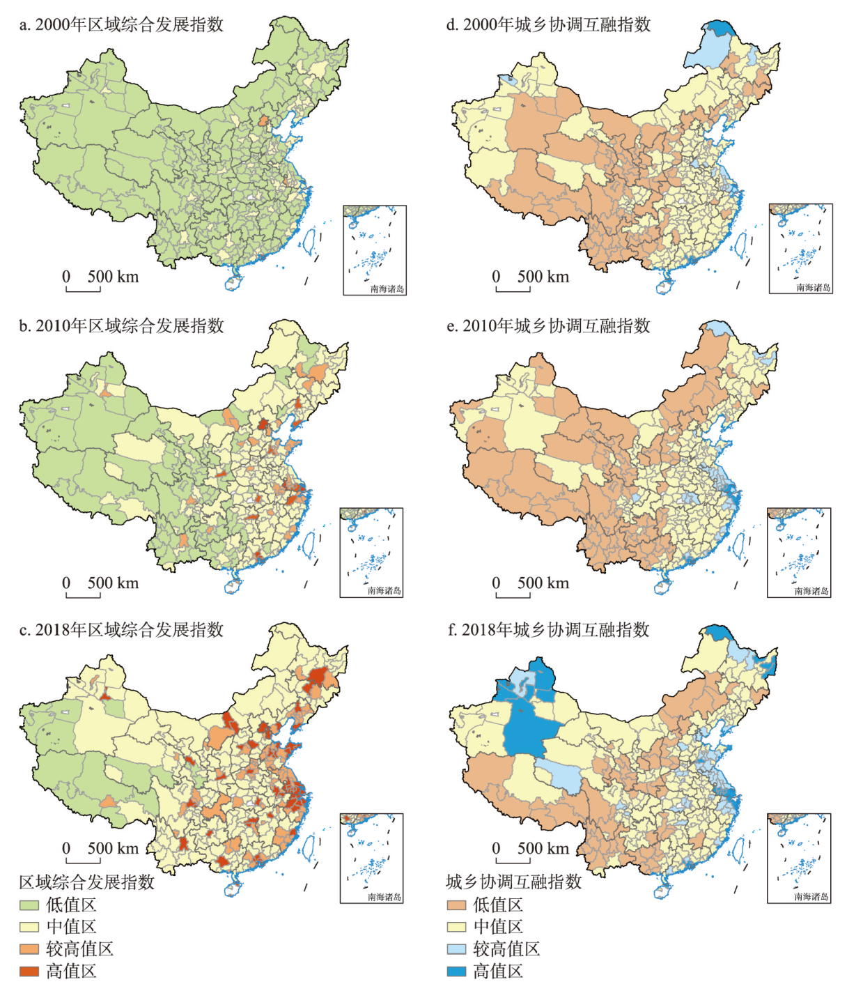
Urban-rural integrated development is an advanced stage in the evolution of the urban-rural relationship, and it is also the basic path and main goal for the implementation of rural revitalization. Scientifically understanding and identifying the integration stage and its current level of urban-rural development in China is the prerequisite basis for promoting urban-rural integrated development and rural revitalization. Based on the concept connotation, this paper constructed a multi-dimensional evaluation system of urban-rural integrated development at the prefecture level. The process status and spatiotemporal divergent characteristics of urban-rural integrated development in 336 prefecture-level regions in China from 2000-2018 were portrayed and revealed. The results show that: (1) The current state of urban-rural integrated development in China is generally at a low-to-middle level, showing a heterogeneous spatiotemporal pattern with apparent gradient divergence. The integrated development level of the Pearl River Delta, Jiangsu and Zhejiang provinces, and the Shandong Peninsula is high, but the regions distributed to the west of the "Hu Line" develops slowly. (2) According to the level and characteristics of integrated development, the 366 prefecture-level regions can be divided into four types: integrated development, tending integration, imbalanced development, and lagging development, with a more active transformation between the latter three types. (3) The development level of urban-rural economic integration is higher than that of demographic and social integration, while the development process of urban-rural spatial and ecological integration shows some natural zonal divergent characteristics. Finally, we identified the problem areas for different types of integrated development and explored the regional promotion path of urban-rural integrated development, which could provide scientific references for the strategies of regional urban-rural development and rural revitalization.
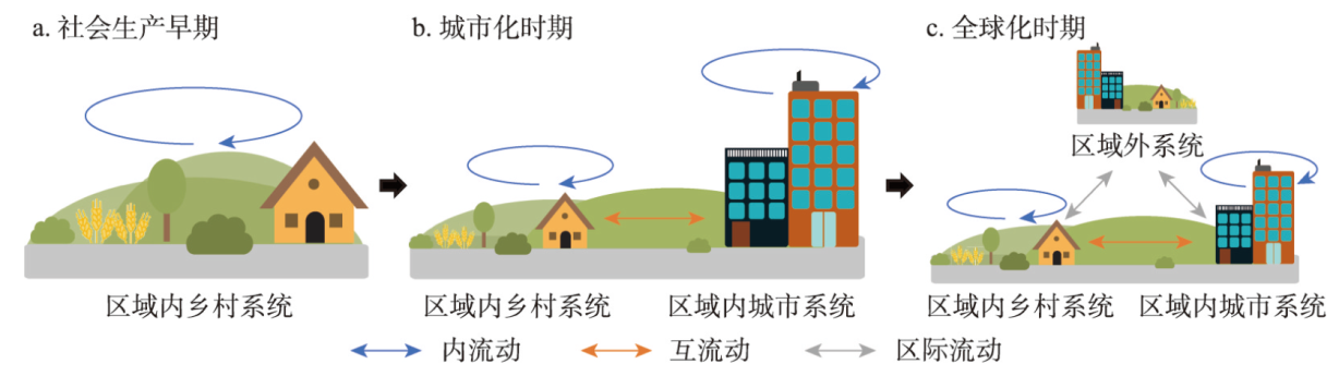
The rational flow of urban-rural factors is conducive to optimize the urban-rural relationship and promote rural revitalization and urban-rural integrated development. Based on the theory of social reproduction, this study defined the connotation and flow types of urban-rural factors, proposed the measurement method of urban-rural factor flow, and quantitatively analyzed the spatial pattern and evolution characteristics of urban-rural factor flow in China. The results showed that urban-rural factor flow referring to the changes of factors affecting urban and rural development can be divided into three types of internal flow, mutual flow, and inter-regional flow. Significant spatial differences and a gradual increase of flow intensity existed in the mutual flow of population, capital, technology, and agricultural products between urban and rural China, while great spatial differences were found in the inter-regional flow of population, capital, technology, and agricultural products without conspicuously increased flow intensity. The intensity and structure of urban-rural factor flow were comprehensively affected by adjusting the scale and structure of social reproduction under the regulation of natural resource endowment and human regulation. The free two-way flow between urban and rural areas can be realized from the aspects of selecting reasonable human intervention means and optimizing the allocation of factors in the social reproduction process, according to regional factor endowment differences and factor flow characteristics at different scales.
Despite the initial development goals achieved, China's macro-economy is still deeply affected by the external environment and stuck in its own structure at the same time. In retrospect, not until 1949 with the founding of the People's Republic of China did China's budding regional economy witness the prominence of a fixed development pattern shifting from a spontaneous to an actuating one. After comparing the three regional economic practices, this paper finds that each development stage has its corresponding development strategy. At the same time, several development patterns, namely, the coastal and inland areas, the three regions, and four plates were formed accordingly. Furthermore, through combing the literature and historical facts, this paper determines the historical starting point, division criteria and division scheme of China's regional economic development before summarizing three main lines and also contradictions therein: the government-market relations against the background of market reform, the coastal-inland relations against the tide of economic zonation, and the urban-rural relations against the trend of urbanization. Based on the above, the paper constructs a three-dimensional model out of the spatio-termporal process of China's regional development before proposing new historical stages from the perspective of economic system modernization. These historical stages are: industrial economy, special zone economy, district economy, regional economy and urban network economy. Finally, from the urbanization angle, this paper concludes that for different urbanization stages, regional policies should be industrial policies, factor policies, fiscal and tax policies sequentially.

The actor-network theory (ANT) provides a new approach for multidisciplinary research by equally treating human and non-human actors and exploring the dynamic relationships between them. This paper incorporates ANT into geographical research on border trade and develops an ANT-based framework for analyzing the development of border trade, with a focus on the agency of state or regional actors. These efforts contribute to ANT's attention to the particularity of human actors and the expansion of its research scale to the macro level. The case study of Tibet's border trade at NathuLa, Gyirong, and Burang in the 21st century is used to examine and compare the interactions among heterogeneous actors in China, India, and Nepal, and to suggest ways to enhance the trade. The main conclusions can be drawn as follows: (1) The analytical framework shows that, led by state or regional actors, the development of border trade is still jointly driven and influenced by local and non-human actors through the translation process of problematization, interest, enrollment, mobilization, and dissidence. (2) In the case study, as the focal actors, the central governments of China, Nepal and India uniformly lead the translation processes and interactions of heterogeneous actors, which are also contained by non-human actors like international relations among the three countries, fragile geographical environments and inadequate infrastructure in the Himalayan region. The actor-network of China-Nepal border trade is built up better than that of China-India border trade. In this regard, border trade in Tibet should continue to be optimized in constructing friendly inter-state relations, scientific and strategic research on port planning and development, infrastructure construction on transportation and market, and other human or non-human aspects.

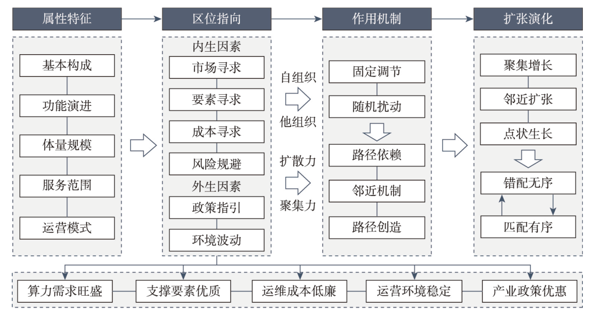
With the coming of digital economy era, the development and application of information technology revolution, such as 5G, cloud computing, big data, Internet of Things and artificial intelligence, production and living of human are being deeply affected. The data center is an important new infrastructure that integrates data storage, analysis, processing and application. It is increasingly important in the global data value chain and plays a strong supporting role in the global digital development. In this context, it is of great significance to clarify the multi-spatial scale expansion laws and location selection mechanism of global data centers, and layout them scientifically and reasonably. This paper integrates spatial statistics, spatial analysis, and spatial measurement methods, and conducts empirical research on the spatio-temporal differentiation and influencing factors of global data center expansion from 2005 to 2020. The results show that: (1) The spatial expansion trend of the global data center is obvious, and the growth center and the economic center move eastward, forming three major growth cores in North America, Western Europe, and East Asia. From the perspective of city scale, city clusters and metropolitan areas are the main spatial carriers of expansion, while a few cities such as Beijing, Tokyo, and Shanghai are the central hubs. (2) The spatial expansion characteristics of the data centers can be divided into contact expansion mode, point growth mode and agglomeration growth mode. (3) The location selection of data center spatial expansion is jointly affected by market size, element supply, and operating environment. However, the measurement method and spatial scale factors in selecting a country or a city are not completely consistent. From the perspective of global scale, market size is the most important factor, and the influence of element supply and operating environment show different stage characteristics; city scale is significantly affected by market size, element supply, and security level.
The study of the new economic geography has paid attention to the polarization and balanced development of urban systems. In reality, however, transport accessibility is subject to great uncertainty in explaining the polarization and balance of the urban system. In fact, the polarization or equilibrium of the regional urban system is not only unique in China, but also a general phenomenon in countries with different development outcomes, political systems and degrees of marketization. From the perspective of industrial heterogeneity, this study empirically analyzes the process and mechanism of the industrial structure of regional central cities on the population growth of neighboring cities in China from 1980 to 2020, and examines the influence of industrial structure on the polarization and equilibrium development of the regional urban system. The results show that, firstly, the manufacturing sector strengthens the spillover effect from the core city and promotes the population growth in neighboring cities, while the service sector weakens the spillover effect and hinders the growth in neighboring cities. Secondly, the manufacturing-oriented cities have relatively small city scale, while the service-oriented cities are relatively large. Therefore, the driving effect of manufacturing-oriented central cities on the neighboring cities is larger, which tends to produce a relatively balanced regional city system. Correspondently, the spillover effect of service-oriented central cities on the neighboring cities is smaller, which tends to form a relatively polarized regional city system. Finally, as the share of services in the industrial structure of central cities continues to rise, China's urban system may become more polarized rather than balanced. Certainly, the higher the proportion of manufacturing in the central city, the more balanced the regional urban system is. In fact, the empirical results show that the industrial structure and the spillover effect of the core city have an inverted U-shaped relationship, i.e. a high proportion of manufacturing or services weakens the driving effect of the core city on surrounding cities. The reasons for this vary. The high proportion of manufacturing and the small size of the central city have a limited spillover effect on the neighboring cities and therefore can hardly drive their growth; while the high proportion of service industry and the negative effect of the service industry on the spillover effect lead to the slow development of the neighboring small-and-medium-sized cities. It is worth noting that because of the significant spatial impact of industry on the urban system, the future regional urbanization strategy should be coordinated with the industrial strategy. More importantly, with the gradual liberalization of the household registration system, industry selection can become an effective policy option for macro-control of the regional urban system.
As a product of certain type of social interaction, urban scaling laws assume that urban attributes such as urban economic outputs are largely determined by urban population size (internal interactions), implying the assumption of agglomeration economies. Urban population agglomeration represents a local network effect, while the global network effect on a larger spatial scale between cities should also be considered in terms of the improvement of social productivity. Taking 275 Chinese cities at prefecture level and above as the research object, we constructed an urban human mobility network by Baidu migration data and portraied the degree of external interaction by human mobility between cities. We comparatively analysed the non-linear relationship between population size within cities and external interaction and urban economic outputs under the urban scaling framework. Results show that there is a significant super-linear scaling relationship between urban economic output and external interaction, revealing the higher multiplier effect of external interaction on urban economic outputs. The role of network spatial interaction cannot be ignored and it has become an important complement to agglomeration economies. Further, indicators such as urban population density, agglomeration and network externalities are introduced to quantitatively and comprehensively measure the effects of urban population agglomeration and interurban population mobility and their synergistic effects on urban economic outputs. The agglomeration effect brought about by urban population size remains the main driver of regional economic development, and the ability of cities to benefit from exchange and cooperation on a larger spatial scale has yet to be enhanced. This study contributes to fully understanding the origins of urban scaling laws from taking both internal and external interaction into consideration, deepening the recognization of the agglomeration effect and network effect of regional economic growth. This paper is supposed to support for promoting high-quality integrated urban development and deepening the practice of coordinated regional development.
Based on the multi-directional flow matrix and the social network analysis, the paper proposes a system extending and optimizing the connotation and measurement of urban niche, constructs a research framework of urban niche in urban agglomerations from the perspective of space of flows, and takes the Guangdong-Hong Kong-Macao Greater Bay Area (GBA) as a case to dissect the "ecostate-ecorole" characteristics of cities, revealing niche and competition and cooperation relationships of cities. The study shows that: (1) In terms of the overall ecorole, the rank-size distribution of inter-city factor flows in the GBA is the primacy ratio distribution at the level of employment service flow, economic service flow, knowledge flow and ecological service flow, while it is the centralized one at the level of information flow, and the balanced one at the level of comprehensive flow and cooperation flow, with a log-normal distribution pattern. (2) In terms of local ecorole, the city group varies depending on factor flows and is interweaved with each other to form a multi-dimensional flow intensity structure of "core-regional core-margin", of which, Hong Kong and Shenzhen, Guangzhou and Foshan, Zhuhai and Macao, share the closest inter-city cooperation. Meanwhile, three inland city groups show signs, namely, "Guangzhou-Foshan- Zhaoqing", "Shenzhen-Dongguan-Huizhou" and "Zhuhai-Zhongshan-Jiangmen". (3) In terms of macro ecostate, cities play different roles in different factor flows of urban agglomerations, which can be summarized into five types: diffused, benefited, balanced, isolated and intermediary. Also, the participation modes of cities in clusters can be grouped as participation in full and in part, according to the analysis of intercity dominant flow in each factor matrix. (4) In terms of micro ecostate, cities share complex partnership and competitive relationship. There are 11 pairs of reciprocal partners, 7 pairs of complementary partners, 42 pairs of fierce competitors and 31 pairs of mild competitors. Based on the flow data, the paper broadens the perspective of study on urban niche of urban agglomerations, and puts forward a new idea of improving the spatial structure of urban agglomerations and regional competition and cooperation relationships, so as to provide a valuable decision-making basis for building the GBA into the world-class city cluster.

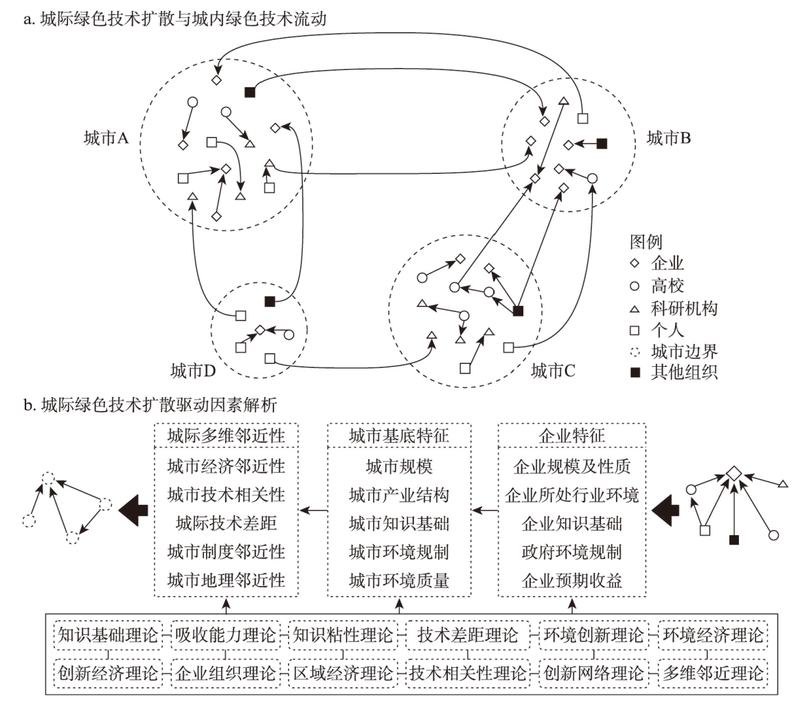
Building a market-oriented green technology innovation system to accelerate the diffusion of green technology between regions, cities, and institutions has become a national strategy. Using green patent transfer to characterize the diffusion of green technology, this paper analyzed the temporal development dynamics and spatial distribution pattern of green technology diffusion in China from 2001 to 2020, and also discussed the main factors driving the diffusion of green technologies in Chinese cities. The study found that from 2001 to 2020, the popular technologies in China's green technology market rapidly changed from environmental governance technology to green building technology and clean energy technology, while enterprises were always the main actors of green technology diffusion. Secondly, from 2001 to 2020, with the cross-city flow of green technology becoming the new normal, a unified national green technology trading market was gradually taking shape. Thirdly, green technology diffusion activities were highly concentrated in the "T" region composed of the eastern coastal areas and the Yangtze River Economic Belt, in which the inter-city green technology diffusion formed a diamond network with the Beijing-Tianjin, Yangtze River Delta, Pearl River Delta and Chengdu-Chongqing regions as the hubs. Fourthly, following the principle of preference connection and the law of assortativity, new cities in the intercity green technology diffusion network tended to obtain green technology from hub cities, but the flow of green technology between hub cities was more frequent. Fifthly, the regression results of the model under the multi-dimensional proximity analysis framework also verified the above laws, and revealed the differences in the formation mechanism of intercity green technology diffusion caused by technology gap, geographical proximity, economic proximity and cognitive proximity among cities.
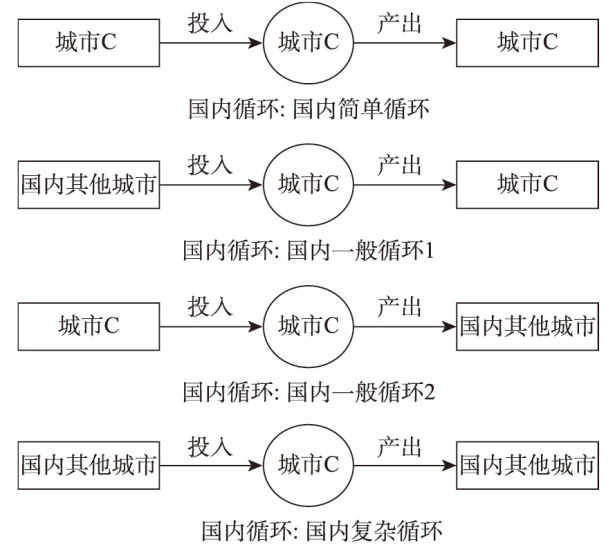
As a key node of inter-regional input and output, the participation of dual circulations of cities is of great significance to the construction of a new development paradigm. Based on the value-added decomposition framework of WWZ, using the latest Chinese inter-city input-output tables in 2012, 2015 and 2017, this paper constructs participation indicators of "dual circulations" at the city-industry level, and focuses on the analysis of the influencing factors of participation of domestic circulation at the city level. The study found that: (1) In 2012, 2015 and 2017, the overall domestic circulation participation in China was 71.62%, 72.42% and 74.08%, and the international circulation participation was 28.38%, 27.58% and 25.92%, respectively, which shows that the dominant position of China's domestic circulation is gradually strengthening. (2) At the industry level, the domestic circulation participation of manufacturing industry is low, which is closely related to its deep embeddedness in global value chains characterised by trade in intermediate goods. In contrast, the service industry has higher participation, which is in line with its poor tradable characteristics. (3) At the city level, the participation of international circulation in eastern cities is high, with an average of 30.74%. The participation of domestic circulation in central and western cities is relatively high, with an average of nearly 90%. China is gradually forming a spatial distribution in which the central and western cities are dominated by domestic circulation and the eastern coastal cities are dominated by international circulation. (4) Foreign direct investment is not conducive to the improvement of domestic circulation participation in urban China. while the level of transportation infrastructure and government intervention will help further strengthen the dominant position of domestic circulation in urban China. At the same time, the domestic circulation participation of the four major sectors shows different influencing factors.
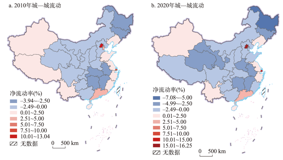
There are important changes in urban-rural structure of population mobility at the late-intermediate stage of urbanization in China, which will have a significant impact on population redistribution, urbanization and regional development. This paper divides the interprovincial urban and rural floating population into four mobility types by using the 2010 and 2020 censuses data, and on the basis of identifying the mainstream types, their spatial patterns evolution and the relationship with regional economic development are investigated through the mobility ratio indexes and regression models. The study results can be summarized as follows. (1) The urban and rural floating population is large and grows rapidly. Meanwhile, rural-urban mobility keeps the dominant position, and urban-urban mobility rises rapidly, these two population mobility types have become the mainstream ones of interprovincial urban and rural floating population in China. (2) In terms of the net mobility pattern of urban-urban floating population, the net-inflow areas are further concentrated in the three major coastal centers of Beijing, Shanghai and Guangdong, and Liaoning, Xinjiang and Yunnan are also maintained at a certain net-inflow rate, but most of the provincial-level regions are in the net-outflow areas. The major changes of the net mobility pattern of urban-urban floating population have shaped a spatial connection network. The main features of this network can be described as three cross-regional flow circles of Beijing-Tianjin-Hebei, Yangtze River Delta, and Pearl River Delta in coastal China. At the same time, the space connections within the regions are strengthening in northeast China, northwest China and southwest China. (3) The net mobility pattern of rural-urban floating population shows that in coastal areas, the net-inflow rate rises or decreases during the study period, while in inland areas, the increase in the net-inflow rate of Liaoning and Xinjiang leads to the decline in the net-outflow rate of their neighboring provinces. The changes of the net mobility pattern of rural-urban floating population depict the dual characteristics of continuous formation and different changes of the coastal flow circle, and the development of the inland flow circle in Xinjiang and Liaoning. (4) There is a mutual relationship between urban-urban and rural-urban population mobility and regional economic development. For regional economic development of both population mobility types, the impact is significantly positive and has been increasing. When we add the floating stock into the models, the positive effect of this variable has decreased in urban-urban mobility's model, while it still plays the first-place positive effect in rural-urban mobility's model. The two population mobility types have a positive effect on the national economic development and the inflow areas' economic development.
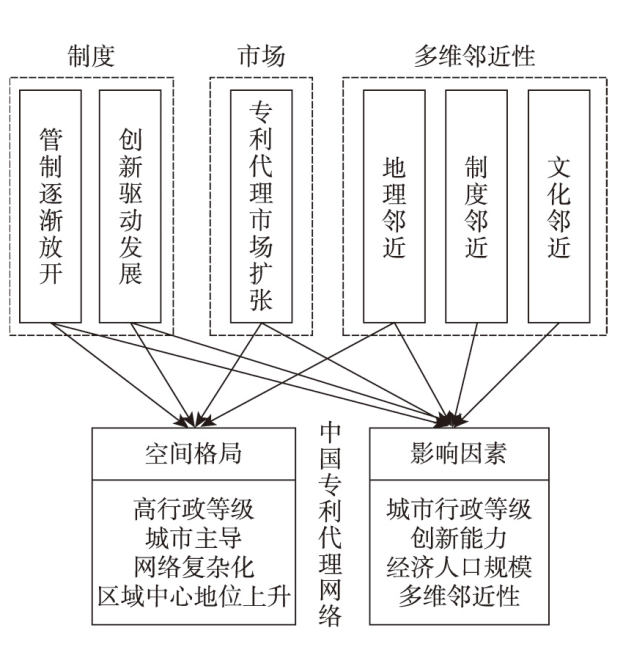
Patent agency service is an important support to promote the creation, application and protection of intellectual property in the context of high-quality development. In this study, the network characteristics and influence mechanism of patent agency services were explored using the social network analysis method, spatial analysis method and econometric model. The patent service network in China shows a trend of expansion in scale and complexity in structure. From a single core in Beijing, the innovation service network gradually transforms into a multi-core topology. The innovation service network space has changed from the single two-tier pattern of "Beijing-Guangzhou" and "Beijing-Shanghai" to the complex structure of "Beijing as the core, with the coexistence of multi-nodes". The diffusion of innovative service flows is reflected in the form of hierarchical and contagious diffusion. The market-oriented changes in the patent management system and the spatial expansion of the demand for patent services have jointly shaped the pattern and evolution of the patent service network. The econometrical results show that the administrative hierarchy level, economic and population size, innovation capacity, and multidimensional proximity of the service city and the served city can significantly enhance the innovation service linkage between cities. This study, for the first time, explores the characteristics and evolutionary mechanisms of urban networks from the perspective of IP services. It emphasizes that administrative hierarchy, market size, and relational proximity jointly contribute to the system and evolution of urban networks, and enriches the study of innovation geography from the perspective of service linkages.
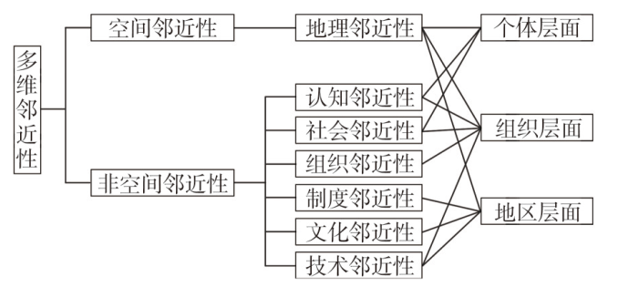
Multidimensional proximity is a major driving force for promoting knowledge flows and forming innovation networks, but from the perspective of proximity, the micro-mechanisms through which inter-individual social relations influence the formation of multi-scale innovation networks remains unclear. Taking the Yangtze River Delta megalopolis as the research region, and conducting questionnaire surveys of 926 corresponding authors who have published papers in Web of Science Core Collection, this paper identifies social relations of paper co-authors and builds a multi-scale urban innovation network to explore the influence of multidimensional proximity between individuals on the formation of multi-scale urban innovation networks. The study finds that: (1) The social relations of paper co-authors can be divided into three types: geography, learning, and business ties. They promote knowledge flow at different scales through geographic, cognitive, and social proximity, which can explain the micro-mechanisms of the formation of multi-scale urban innovation networks in the study region. (2) In general, the influence of geography ties on knowledge flow at different scales is indirect, the influence of learning ties is reflected at the megalopolitan, national, and global scales, and the influence of business ties is mainly reflected at the national scale. In addition, cities with stronger external innovation connections tend to have more diverse manifestations of the geography, learning, and business ties. (3) Compared with business ties, learning ties exert a stronger overall impact on urban innovation network at each scale, indicating that cognitive proximity at the individual level is more conducive to promoting knowledge flows than social proximity. (4) Both the supervisor-student relationship based on learning ties and project-based relationship based on business ties play significant roles in the formation of urban innovation networks at different scales. The former is mainly presented due to the transfer and sharing of tacit knowledge during the flows of talents, the latter is mainly manifested by a relatively solidified cooperative matching mode formed between cities with stronger innovation capabilities.
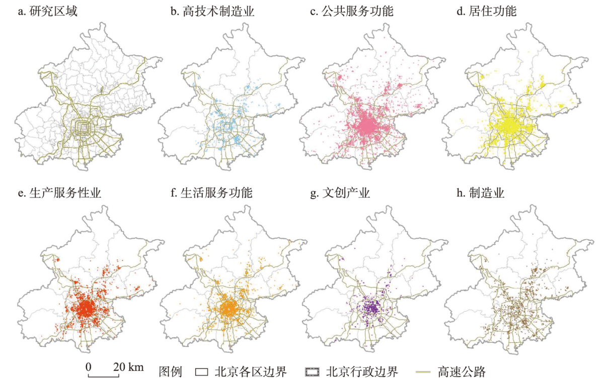
Beijing has transitioned from the growth stage to the spatial renewal and improvement stage. Specifically, the evolution of urban functional space is an important symbol and spatial carrier in the process of development and transformation. This paper analyses structural modes and aggregation laws of spatial evolution based on long-term functional datasets, aiming to provide decision-making support and criteria for scientific reconstruction and refined governance of urban functional spaces. It is found in this study that: (1) the main centre of urban functional evolution of Beijing is located in the core area and migrates eastwards; the sub-centres and outer suburban centres are further formed, showing an evolutionary trend that polarisation goes before stabilisation; (2) the differentiation characteristics of the functional spatial pattern are significant; (3) the evolution of functional space presents a structural mode of polarisation of service function centres, sequential spillover of industrial function, and differentiation of residential function circles; (4) the aggregation laws of functional evolution include the separation of work and residence as a spatial response to the capital's service-oriented single-centre structure, the equalisation of public services as an important support for upgrading the quality of urban residential space, and the industrial agglomeration and transition as a key path for iteration.