

1 引言
山洪广泛发育于约占中国陆地面积2/3的山丘区,是山地小流域表层物质快速输移的过程[1],暴发突然,破坏性强,形成过程复杂,预测预报困难,往往造成毁灭性灾害,严重威胁广大山丘区人民生命财产和重大工程安全,制约社会经济的高质量发展。而且,随着全球气候变化加剧,山区局地极端强降雨频次增加,进一步增大了山洪灾害的不确定性和危害性[2]。壤中暴流(Subsurface Stormflow)作为山洪形成的主要水源和重要产流机制,深刻地影响着山洪的孕育、形成和发展过程[3-4],是特大山洪泥石流链生灾害研究的重要突破口。然而,壤中暴流的来水具有强非恒定特点、主要流通路径为复杂多孔介质[5]且空间不均匀性较高[6],导致其演变过程及成灾效应表现极端复杂性和高度不确定性[7⇓-9],加之水文数据资料的稀缺[10],对深入认识壤中暴流的水文机理和灾害效应、构建基于物理过程的理论体系形成巨大挑战,限制其内涵、外延、研究对象、物理过程等理论方法体系与核心内容的发展和完善。
自“1965—1974年国际水文发展十年计划”颁布以来[11⇓-13],众多学者主要基于壤中暴流和降雨量的线性关系假设开展系列水文现象学研究,直到21世纪初,逐渐认识到壤中暴流与输入变量降雨之间的非线性关系,并开展水文过程的机理研究[4,14⇓⇓ -17]。壤中暴流与山洪灾害关联密切,而山洪死亡人口占中国洪涝灾害死亡总人口年均比例高于70%[18],使得山洪形成机理研究成为当前新时期水灾害及水文科学发展面临最重要的任务之一。深化壤中暴流水文机理与致灾效应研究,有助于揭示变化环境下山区流域水文过程与山洪形成的时空演变规律,构建考虑壤中暴流机制的山洪形成理论体系和模型,可为山区小流域山洪的预测预报和防灾减灾工作提供重要理论与科技支撑。
本文拟针对壤中暴流科学内涵的复杂性,从物理过程和发生条件出发界定壤中暴流概念的内涵与外延,梳理壤中暴流的发生条件和水文响应过程,总结其对成洪致灾机制的影响,最后提炼了未来研究需要关注的关键科学问题。
2 壤中暴流的概念与科学内涵
2.1 壤中暴流定义
国际上,壤中暴流(subsurface stormflow)也称间流(interflow/throughflow)、侧流(lateral flow)、地下径流(subsurface runoff)、瞬时地下水流(transient groundwater)与土壤水流(soil water flow)[11,15,19]。众多术语的存在主要由于对降雨或融雪、融冰、灌溉渗漏等供水后壤中暴流水文响应物理过程理解的不全面。虽有研究将壤中暴流认为非饱和区的非饱和流[11],但大多研究认为,壤中暴流是一种饱和(或接近饱和)的水流过程,主要是由地下水位上升至透水性更强上部土壤中形成侧向流动,或在低透水层上方出现瞬时饱和流的过程[4,20⇓ -22]。
国内学者对该术语的概念表述与译文,最早可以追溯到1984年地质矿产部水文地质工程地质研究所出版的《水文地质词汇(英中法德俄文对照)》[23],将“subsurface runoff”“subsurface flow”“subsurface stormflow”放在同一项目下解释为“地下径流,暴雨渗流,地下水流由下渗的降水在地面下作侧向运动而形成的水流”,1985年刘光文等编订的《英汉水文学词汇》[24],并将其译为“[次]表层流,壤中流”;《英汉给水排水辞典》[25](1989年)译为“暴雨渗入地下水流”;《现代英汉水利水电科技词典》[26](1990年)译为“[次]表层流,壤中流,暴雨渗入地下水流”;《汉英英汉水利土木工程词典》[27](1992年)将其译作“暴雨地下流量;表层流;壤中流”;《英汉水科学词汇(新编)》[28](2002年)翻译为“暴雨渗流,土壤浅层侧向流”;亦有文献或书籍[29-30]将其译为“地下暴雨径流、地下洪流、快速壤中流”。芮孝芳编著的《水文学原理》[31](2012年)将其译为“壤中水径流”,并提出与“超渗地面径流”、“饱和地面径流”、“地下水径流”产生物理条件的差异性,但并没有给出明确的定义和概念;张艳军等主编的《山区小流域洪水过程及其模拟》(2021年)[32]将其译为“壤中暴雨流”,在国内首次给出了基本概念,突出了“subsurface stormflow”在山洪形成与模拟中的重要性,但概念中对其物理过程和发生条件表述仍有所欠缺。
总体而言,国外学者并没有从物理过程和形成条件出发给予“subsurface stormflow”准确的概念和定义。笔者认为“壤中暴流”作为“subsurface stormflow”的中文译法更为合适,主要原因包括:① 机理层面上,它是供水(降水)与下渗矛盾在一定介质条件下的发展机理和过程,是一种产流机制,如蓄满产流与超渗产流,而区别于单纯的“优先流”渗流过程(图1);② 水源层面上,该过程主要区别于蓄满、超渗产流形成的表面径流,也不同于喀斯特地区深层地下流或地下河,主要是壤中流起主导作用,发生位置主要位于土壤—基岩界面及其以上的包气带。③ 形成特征上,它极易发生于地形陡峭、气候湿润、土壤渗透强的土石山区,产流多且流速高,是山洪来水的重要组分,表现为:快而多,“暴”字形象表征了这一特点。
图1
图1
壤中暴流形成机理示意图
Fig. 1
Schematic diagram in formation mechanism of subsurface stormflow
在此,我们认为壤中暴流主要指供水充足且高渗透性坡体的包气带,由重力自由水主导通过大孔隙通道、相对不透水界面而快速出流的现象。它具有非饱和带—暂存饱和带界面共存、水力梯度大、多界面变动产流的特点(图1)。壤中暴流作为一种产流机制的具体定义为:通常由暴雨或融雪、融冰、灌溉渗漏等供水期间,地表以下水流透过土层或风化层基岩等高渗透区,并在土壤间低渗透界面或基岩—土壤界面形成的坡面—河道水文连接通道向坡下快速运动的一种产流机制。
2.2 壤中暴流研究的渊源
壤中暴流的研究主要经历了3个主要发展阶段:发现提出阶段(1919—1960年)、规律探索阶段(1960—1980年)与形成机理研究阶段(1980年至今)。
(1)壤中暴流现象发现与初期研究阶段(1919—1960年)
壤中暴流水文理论最早可追溯到1919年,瑞士著名水文学家Engler教授[33]通过自然降雨观测到森林实验流域坡面根际区的强烈入渗作用以及土壤中或基岩—土壤界面上的“无数缝隙”的横向坡下运动过程,且并无坡面漫流出现,首次强调壤中暴流在森林水文过程的重要性。1936年,“Subsurface stormflow”由美国伊利诺伊州水文学家Hursh教授在著名的科维塔(Coweeta)实验流域水文研究中提出[34]。后来10多年,他通过流域暴雨洪水过程的原型观测,开展径流分割与水源研究[35⇓-37],首次明确暴雨过程中流域尺度壤中暴流是洪水过程的重要组成水源。虽然壤中暴流产流理论与1933年Horton超渗产流理论 [38]的提出时间几乎同步,但因为壤中暴流形成运动过程的复杂性、流通路径的隐蔽性与数学概化的高难度性,并未引起水文学者广泛重视。
(2)壤中暴流规律探索阶段(1960—1980年)
直到20世纪60—70年代,通过国际水文十年计划(International Hydrological Decade, IHD),Whipkey[39]、Dunne等[40]、Weyman[41]、Harr[42]、Mosley[43]等一些水文学家逐渐开始通过野外坡面观测与人工降雨实验,开展坡面尺度壤中暴流的现象学研究。如英国布里斯托大学水文学家Weyman[41]开展坡面天然降雨观测(开挖60 cm深槽,剖面呈现上覆土与不透水基岩),建立了坡面侧向排泄径流、水位与时间的函数关系,是最早采用坡面地下非饱和流与饱和流总势能概念对壤中暴流进行现场定量的研究。此外,美国农业部Harr[42]教授通过流域精细化观测发现了降雨期间侧向下坡流域垂直下渗流大致相等,壤中暴流是洪水过程的主要径流来源,占据降雨总量比例高达38%。基于坡面、流域(非)饱和流过程的定性认识与定量论证,推动了壤中暴流的现象学研究,为壤中暴流水文机理在其他地质地貌环境下产流路径与响应过程的研究奠定了理论基础,对坡面壤中暴流研究具有深远的意义。
(3)壤中暴流形成机理研究阶段(1980年至今)
为了解决流域壤中暴流水源形成、水流路径的科学难题,20世纪90年代左右,一些水文学家开始尝试借助染色剂、水化学(电导率EC、Cl-)、水同位素(δD、δ18O)等示踪剂定性或半定量研究“老水”“新水”问题、“水流路径与水源”问题,并阐明了“基岩—土壤界面水位寿命极短,与坡面渗流速率几乎相近”的观点,证实了壤中暴流快速补给径流的特点[44⇓⇓⇓-48]。同时,Woods等[49]、Harris[50]、McDonnel等[51]、Burns等[52]、Freer等[14]研究发现,坡面基岩形态可显著控制壤中暴流过程,特别是基岩洼地能够影响壤中暴流初期产流过程。该发现有力推动壤中暴流理论的发展,直到21世纪仍在众多实验区得到验证[4,8,16,53 -54],逐渐形成研究的主要模式与概念、理论模型。例如,两种典型的壤中暴流产流模式(图2d、2e)被广泛接受,第一种模式主要指暴雨过程中更深、更持久的地下水位上升后,与渗透性更强的多孔介质相交,导致横向快速流动[16,55]。第二种模式主要指在渗透差异大的界面(如土壤层、土壤—岩石界面)[8,53 -54],通过土壤管网[15]或风化层基岩裂缝[56]产生横向快速下坡流,贡献于洪水径流。其中,第二种模式更为普遍。
图2
2.3 壤中暴流与其他产流机制的差异性
从产流变化速率和时间效应来看,壤中暴流过程以重力自由水为主,包气带水力梯度大,壤中水流速度快,岩土体—坡面—河道具有较好的内部水文连通条件[6],但水流通过包气带若干界面水分再分配过程,产流响应时间较超渗产流略有滞后。对比之下,超渗产流变化速率快,响应时间短;蓄满产流以束缚水和毛管水为主、重力自由水为辅,产流前期包气带至饱和带水力梯度小,内部水流速度慢,产流响应时间更加滞后,产流后期流动特点与超渗产流相似;地下水产流流速慢,响应时间最慢,有时以年来计量。综上所述,4种产流模式在响应时间方面的整体排序为:超渗<壤中<蓄满<地下水。
3 壤中暴流的发生条件与水文响应过程
3.1 壤中暴流发生条件
(1)水源供给条件
降雨雨强或融雪、融冰速率小于包气带上部地面下渗率,水源供给量应充足,通过包气带上部所损耗的束缚水、毛管水、重力水与蒸散发量,在下部应有多余的土壤水超过饱和含水量阈值,在通道界面形成的支持重力水量可达到土壤—坡面—河道自由水水文连通阈值,确保坡面出口壤中产流发生。
(2)岩土体孔隙结构与水流通道条件
壤中暴流所发生的包气带中存在相对不透水界面,界面上部岩土体孔隙极为发育,常伴有大孔隙结构,且孔隙率远大于下部孔隙率,同时,界面处横向孔隙结构与孔隙率应略大于界面上部的等效孔隙率。包气带岩土体应存在上部孔隙通道和界面通道,并与坡面、河道连通,界面上部流通路径较为复杂,以大孔隙非连续流为主,水流速度快,处于非饱和状态;界面处流通路径相对单一,但摩擦系数较垂向通道适当增加,水流过程主要以壤中浅层近似饱和流为主,连通坡面与河道水文通道,空间动力过程易被概化。
(3)水力梯度条件
包气带所存界面上部主要由土水重力势主导,渗透重力自由水垂直贯穿包气带,水流阻力小;界面处形成暂存饱和带,横向水流阻力较垂向有所增大,主要有土水重力势和压力势共同主导,形成支撑重力自由水。当坡面达到一定坡度阈值时,包气带和暂存饱和出现较高的水力梯度条件,促进重力自由水与支撑重力水以较高流速流动,在土壤—坡面—河道瞬时连通可发生壤中暴流。
3.2 水文响应非线性过程
输入变量降雨或融雪、融冰等水通量通过结构复杂的包气带与饱和带,受到输入条件的时空变异性、地形地貌的差异性、岩土体内部孔隙结构的复杂性、岩土体内部水分迁移的随机性与不均匀性等条件的约束,形成的壤中水径流量与输入水量间往往呈非线性水文关系,如Ali等[60]提出的4种水文非线性行为表现形态(图3):① 曲棍球棒曲线式(Hockey Stick Shape)[11];② 赫维赛德阶跃函数式(Heaviside Step Function)[61];③ 狄拉克函数式(Dirac Function)[62];④ S型函数式(Sigmoid Function)[63],其中,国内外水文学家通过野外实验观测到二线段水文阈值行为——曲棍球棒曲线式(图3a),更为普遍存在[17,57,64⇓⇓ -67]。即当降雨量达到一定的量值后,产流量出现突变的现象,并呈近似线性关系。
图3
从输入水源供给条件看,降雨强度、规模、历时与空间分布均可造成水文非线性响应在时间与规模上产生明显差异。如前期降雨量大、历时短,空间分布集中,产流初损时间显著缩短,土壤—坡面—河道壤中水文过程瞬时连通。
从黑箱系统内部结构看,坡面岩土体孔隙结构复杂、相对不透水界面随机性强、垂直与横向水流通道多变、水力坡降空间分布不均等条件使流域与坡面过程无法满足线性叠加,导致壤中水流过程要素的时空耦合作用并非唯一性,具有极强的非线性特征。如坡面基岩洼地深且分布多,岩土体蓄水容量少,致使初期产流阈值增大。坡面地形越陡峭,水力坡降增加,产流时间缩短,产流量变化率增加,斜率增大(图3a)。
研究表明,流域产流初期阈值主要受坡面岩土体蓄水容量特性、坡面基岩洼地形态与数量、坡面包气带层理结构与界面特征控制[4,20,54 -55,58,68],水流主要以受分子力作用形成的吸湿水或薄膜水形式出现[69],不易快速流动,响应时间较长。水流也可能以重力自由水形式填充基岩洼地但未达到溢出,坡面与河道的水文过程尚未连通[4,54]。当土壤内部蓄水容量达到一定值时会发生“逾渗转变”过程,坡面与河道连通的水文过程出现,致使产流发生首次突变现象。理想条件下降雨全部转化为径流时,降雨—径流阈值函数关系的斜率(k)应呈45°(k = 1),但受流域气候水源条件及地形条件、岩土体前期蓄水容量、孔隙结构与流通路径等实际条件的影响,流域产流也呈现不同的非线性特征(图4),在世界范围内各代表区均发现该特征,新西兰Maimai[43]、墨西哥瓜达拉哈拉Lake Zapotlan[70]、中国四川龙溪河[4]、日本冈山附近山区(Tatsunokuchi-yama)示范区流域[71]、美国加利福尼亚科维塔实验流域(Coweeta Hydrologic Laboratory)[68]及中国和睦桥流域[72]。该产流现象揭示了坡面产流的阈值效应及突变特点,解析了不同气候区森林流域山坡优先流大量发育、壤中暴流的快速出流过程[16,20,61,65],阐明了流域山洪形成的激增特征和水源贡献路径。
图4
图4
不同代表区流域降雨径流非线性关系示意图
Fig. 4
Diagram of non-linear relationship between rainfall and runoff in different representative basins
4 壤中暴流致灾机理
壤中暴流作为陡峭湿润山区的重要水源路径和主导产流机制,深刻影响着山洪规模、峰现时间与成灾过程,主要体现以下3个方面。
(1)壤中暴流具有水文连通性强与流动迅速的特点,是山洪突发性强的重要原因。壤中暴流发生的坡面地形陡峭,水力坡降大,坡面内部大孔隙结构极为发育,土壤—坡面—河道结构连通性强,通道内部水流阻力系数小,壤中水流以重力自由水出流,相对蓄满产流机制来说,速度更快,响应时间更短[73];山洪成洪阶段,坡面基岩洼地填满溢出,形成坡面—河道快速流通的水文通道,且坡面下部位置饱和区面积逐渐扩大,表面径流响应时间显著缩短,坡面径流与河道洪水迅速形成,径流贡献量快速增加,峰值流量快速提高,峰现时间显著缩短,突发性强。如中国西南湿润区壤中暴流产流机制主导的龙溪河流域,流域滞时(TL)可短至0.58 h[4],成洪迅速,具有很高的山洪灾害风险。
(2)壤中暴流具有多产流过程叠加的时空耦合非线性特征,可诱发高强度、大规模山洪。壤中暴流在坡面实际环境需要流通包气带复杂孔隙路径,受坡面地形、岩土体前期蓄水容量、坡面水力梯度、基岩洼地与形态等因子的协同影响,常伴有蓄满产流与地下水产流过程,具有坡面表面径流、壤中径流、地下径流三水源的多空间耦合的产流过程和非线性响应特征(图5)。如坡面壤中暴流发生时,在坡度作用下不断地向坡脚方向流动,坡脚逐渐形成饱和区(也称变水源产流面积),水流遇到应力薄弱的饱和土壤与非饱和土壤分界处,壤中水出流形成饱和地面径流,连通土壤—坡面—河道水文过程,变动源产流面积显著增加(图5b~5d);壤中暴流流经基岩—土壤界面时,基岩下部区域常伴有一定的裂隙通道,渗漏至基岩裂隙通道中,引起地下水产流。
图5
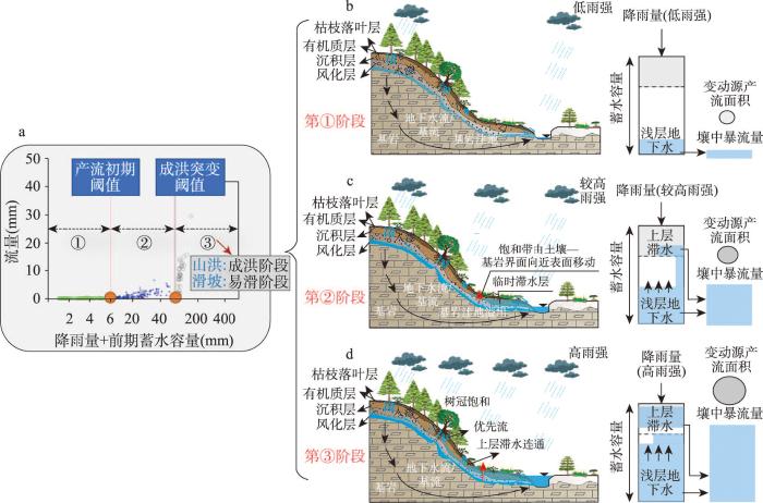
图5
高陡山区壤中暴流影响下的坡面水文过程与山洪成灾机制概念图
Fig. 5
Conceptual map of hillslope hydrological process and disaster-causing mechanism of flash flood affected by subsurface stormflow in high and steep mountain regions
降水渗入流经坡面内部微观系统复杂结构与路径,形成的壤中暴流响应过程较超渗产流表面快速响应略滞后,但因系统中水流的随机性、无序性、复杂性与不均匀性,产流的宏观累积效应常表达出高强度非线性行为,可解析山洪的径流激增机制。如,降雨产流过程普遍存在二线段突变行为,即当降雨量达到一定量值后,产流量出现突变现象,同时,随着雨强增加,产流阈值后期产流量表现出较强的离散特性[74],单一线性关系不能很好刻画暴雨成洪过程,限制了在山洪形成发展及其激增致灾过程的认识。由此,2017—2022年笔者结合已有山洪形成理论研究,联合国内外学者,提出了流域尺度的产流初期、成洪突变的双阈值—线性三阶段规律和响应函数[4](图5),解决了山洪成洪突变非线性过程难以定量描述的难题,揭示了非饱和土壤蓄水容量与降雨深度对山洪形成—发展的动态控制作用,定量研究了暴雨强度与规模对成洪的主要控制作用,推动了微观水文机理研究到宏观成灾水文响应过程的跨尺度理论研究。
(3)壤中暴流发生的水文通道与界面,影响坡面岩土体物源结构稳定性和破坏过程,可诱发强破坏力的滑坡、泥石流灾害。山区斜坡包气带结构常由树根生长和腐烂等生物活动、在张力作用下开裂、干湿循环或冻融作用而引起的大孔隙,水流入渗过程中因横向差异流动,可驱动或侵蚀土壤颗粒,形成横向大孔隙土管道,普遍存在于滑坡的后缘陡壁中[75],直径可达几厘米至几米不等[19,76]。暴雨径流通过垂直或横向大孔隙渗入至低渗透界面或基岩—土壤界面(图6b),形成近似饱和的壤中暴流过程或暂存饱和带,土管道网中水文活跃部分开始扩展,孔隙水压力增加,土体抗剪强度弱化,极易形成浅层滑坡[77-78]。在水源充足条件下,考虑坡面与沟道运动中的水—土耦合过程,山洪、滑坡灾害可逐渐演化成泥石流灾害(图6a),灾害规模与破坏力度可成倍增加。
图6
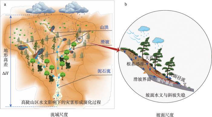
图6
壤中暴流影响下的山洪、滑坡与泥石流链生灾害发生过程
Fig. 6
Diagram of flash floods, landslides and debris flow chain disasters affected by the subsurface stormflow
5 需要深化研究的科学问题
深化壤中暴流水文机理的理解和理论认知,对于高陡湿润土石山区山洪形成关键过程理论体系构建和预警预报发展具有重要科学价值。本文主要针对壤中暴流形成过程中坡面岩土体微观孔隙路径复杂性与水文输移动力演化的不确定性、通道界面水分交换的不均匀性、以及成灾过程多产流机制的时空叠加性3个方面的不足,提炼出未来需要关注的3个关键科学问题。
5.1 包气带岩土体大孔隙水分输移过程与水文连通机制
包气带岩土体内部孔隙结构复杂、通道多变,在不同的气候区、地形地貌及土壤植被类型中均有不同,影响整个包气带壤中暴流形成过程中的水文流通性与水分储量。特别是地震、火山、冰川退缩等内源性灾害与外源性强扰动地表过程的区域,岩土体大孔隙通道内水分输移动力过程更为复杂。因此,明确不同典型区包气带岩土体大孔隙空间的结构特征(如数量、长度、宽度、空间水力半径及分布特征)、孔隙水压力与局部渗透系数等微观信息,定量刻画外部水源补给条件下岩土体内部垂向与侧向的水力特性与动力演化特征,建立微观流动特性与宏观产流过程的映射关系,构建出具有一定水文相似性分析的理论模块与框架,对于延伸或过渡到坡面宏观累积水文响应规律和区域水文地理研究[84-85]具有重要的理论价值。
5.2 坡面内部岩土体通道界面的水分交换过程及机理
自然坡面内部结构的大孔隙通道具有高度的复杂性和水流随机性,造成内部岩土体颗粒界面与水分交换时空分布极不均匀,具有不同的土壤水赋存形态。而且,内部通道交叉纵横,垂向、侧向通道内部界面主要以渗透重力自由水、支撑重力自由水通过,对周边多孔介质水文交换的影响程度、范围、时效及作用机理依旧存在很大不确定性,影响坡体水文通量的准确评估和参数化量化方案,如新水与旧水的交换[54]。加强量化壤中暴流形成过程中坡面内部不同界面的水文交换模式与过程,是坡面壤中暴流物理过程机理与理论建模研究的前提条件与核心问题。
5.3 复杂坡面地形条件下多产流机制综合的山洪形成机理
自然环境坡面壤中暴流发生时,常伴有蓄满产流与地下水产流过程,具有坡面表面径流、壤中径流、地下径流三水源、变动产流层多空间耦合的产流特点[86],土壤—坡面—河道水文连通过程中,坡面漫流的变动源产流面积显著增加,不同水源发生位置、饱和状态、面积占比以及贡献量等信息也模糊不清,对峰现流量的贡献依旧未能准确量化。此外,不同的坡面、基岩形态、长度等背景参数控制了产流过程的水力梯度和流通时间,影响山洪峰现时刻。因此,应加强壤中暴流影响下变动产流层的理论概化与理论建模,量化坡面条件对山洪成灾的影响,构建考虑多产流机制的山洪形成理论体系和模型,支撑国家山洪的预警预报与防灾减灾工作。
6 结语
立足于山洪产流机理的科学目标和国家防灾减灾的战略目标,本文系统回顾了山洪形成中“壤中暴流”研究的兴起与发展历程,科学界定了“壤中暴流”内涵与概念,剖析了壤中暴流发生的物理条件、非线性水文响应规律及其致灾特征,突出体现壤中暴流是当前山洪、滑坡、泥石流复合链生灾害形成研究的关键水文机制与理论突破口。并凝练出未来需要深化的3个关键科学问题,可促进不同气候地貌区山洪灾害研究从单一产流机制描述向多产流机制综合刻画的转变,推动山洪灾害理论体系发展和减灾原理的深化,支撑国家防灾减灾的理论与技术需求。
参考文献
Theory and method of risk assessment and risk management of debris flows and flash floods
DOI:10.18306/dlkxjz.2016.02.001
[本文引用: 1]

Debris flows and flash floods are widely distributed mountain hazards in China. Effective hazard mitigation and prevention require understanding of hazards formation mechanisms and their potential risks. This article elaborates on the formation mechanism, risk analysis, and risk management of debris flows and flash floods. Surface runoff and material supply volume incensement, hazard scale amplification due to outburst of multiple channel blockages and bed erosion as hazard formation mechanism are discussed. Base on the dynamic process of debris flows and flash floods as well as vulnerability assessment of elements at risk, methods of risk assessment and mapping are proposed. Comprehensive engineering and non-engineering measures for hazards control shall be guided by the result of risk analysis that identifies the hazardous level of debris flows and flash floods and incorporates the vulnerability of different elements at risk. Finally, this article discusses strategies when facing risk of these hazards and puts forward a risk management system that involves the participation of local communities.
山洪泥石流风险评估与风险管理理论与方法
DOI:10.18306/dlkxjz.2016.02.001
[本文引用: 1]
山洪泥石流是中国常见的自然灾害,充分认识其形成机制与潜在风险是防灾减灾的关键。本文阐述了山洪泥石流形成机理,以及风险分析与管理的方法和内容,系统认识了地表产流流量激增、土体破坏物质供给激增、沟道堵塞体级联溃决流量放大和动床侵蚀规模增大等4个山洪泥石流的形成过程,介绍了基于动力过程的山洪泥石流风险评估方法和承灾体易损性评估方法,构建了基于灾害动力过程的风险评估与风险制图方法。进而,基于风险评估结果,提出可用于具体灾害点减灾的风险管理内容和风险调控技术、灾害防治的工程与非工程措施与制技术方案。最后,重点讨论了包括灾害风险预测、临灾预案、灾害防治工程方案等内容的风险处置对策,并形成一套基于山洪泥石流动力过程的风险评估与风险管理理论与方法体系。
Large increase in global storm runoff extremes driven by climate and anthropogenic changes
Weather extremes have widespread harmful impacts on ecosystems and human communities with more deaths and economic losses from flash floods than any other severe weather-related hazards. Flash floods attributed to storm runoff extremes are projected to become more frequent and damaging globally due to a warming climate and anthropogenic changes, but previous studies have not examined the response of these storm runoff extremes to naturally and anthropogenically driven changes in surface temperature and atmospheric moisture content. Here we show that storm runoff extremes increase in most regions at rates higher than suggested by Clausius-Clapeyron scaling, which are systematically close to or exceed those of precipitation extremes over most regions of the globe, accompanied by large spatial and decadal variability. These results suggest that current projected response of storm runoff extremes to climate and anthropogenic changes may be underestimated, posing large threats for ecosystem and community resilience under future warming conditions.
Modeling post‐wildfire hydrologic response: Review and future directions for applications of physically based distributed simulation
Stormflow generation in a humid forest watershed controlled by antecedent wetness and rainfall amounts
The role of macropores and multi-resolution soil survey datasets for distributed surface-subsurface flow modeling
DOI:10.1016/j.jhydrol.2014.02.055 URL [本文引用: 1]
Understanding of critical zone structures and hydrological connectivity: A review
山坡表层关键带结构与水文连通性研究进展
Multi-scale hydrometeorological observation and modelling for flash flood understanding
DOI:10.5194/hess-18-3733-2014
URL
[本文引用: 1]
. This paper presents a coupled observation and modelling strategy aiming at improving the understanding of processes triggering flash floods. This strategy is illustrated for the Mediterranean area using two French catchments (Gard and Ardèche) larger than 2000 km2. The approach is based on the monitoring of nested spatial scales: (1) the hillslope scale, where processes influencing the runoff generation and its concentration can be tackled; (2) the small to medium catchment scale (1–100 km2), where the impact of the network structure and of the spatial variability of rainfall, landscape and initial soil moisture can be quantified; (3) the larger scale (100–1000 km2), where the river routing and flooding processes become important. These observations are part of the HyMeX (HYdrological cycle in the Mediterranean EXperiment) enhanced observation period (EOP), which will last 4 years (2012–2015). In terms of hydrological modelling, the objective is to set up regional-scale models, while addressing small and generally ungauged catchments, which represent the scale of interest for flood risk assessment. Top-down and bottom-up approaches are combined and the models are used as \"hypothesis testing\" tools by coupling model development with data analyses in order to incrementally evaluate the validity of model hypotheses. The paper first presents the rationale behind the experimental set-up and the instrumentation itself. Second, we discuss the associated modelling strategy. Results illustrate the potential of the approach in advancing our understanding of flash flood processes on various scales.\n
Dynamics of pore water pressure at the soil-bedrock interface recorded during a rainfall-induced shallow landslide in a steep natural forested headwater catchment, Taiwan
Hydrologic impacts of landslide disturbances: Implications for remobilization and hazard persistence
DOI:10.1002/wrcr.v53.10 URL [本文引用: 1]
Study on prediction of ungauged basins: A case study on the Tibetan Plateau
稀缺资料流域水文计算若干研究: 以青藏高原为例
Subsurface Stormflow
//
Field studies of hillslope flow processes
//
Contribution of subsurface flow from the upper slopes of forested watersheds to channel flow
DOI:10.2136/sssaj1976.03615995004000060039x URL [本文引用: 1]
The role of bedrock topography on subsurface storm flow
The role of lateral pipe flow in hillslope runoff response: An intercomparison of non-linear hillslope response
DOI:10.1016/j.jhydrol.2005.01.012 URL [本文引用: 3]
Topographic controls on shallow groundwater dynamics: Implications of hydrologic connectivity between hillslopes and riparian zones in a till mantled catchment
DOI:10.1002/hyp.v24:16 URL [本文引用: 4]
Non-linear quickflow response as indicators of runoff generation mechanisms
DOI:10.1002/hyp.v34.13 URL [本文引用: 2]
Physical structure and rainfall controls on subsurface hydrological connectivity in hillslope-riparian-stream continuums
Stormflow generation: A meta-analysis of field evidence from small, forested catchments
DOI:10.1002/2014WR016221 URL [本文引用: 1]
Report of the Committee on Absorption and Transpiration,1935-36
DOI:10.1029/TR017i002p00296 URL [本文引用: 1]
Appendix B: Report of the subcommittee on subsurface flow
Influence of topography and soil‐depth on runoff from forest land
DOI:10.1029/TR024i002p00693 URL [本文引用: 1]
Separating storm‐hydrographs from small drainage‐areas into surface‐and subsurface‐flow
DOI:10.1029/TR022i003p00863 URL [本文引用: 1]
The role of infiltration in the hydrologic cycle
DOI:10.1029/TR014i001p00446 URL [本文引用: 1]
Subsurface Stormflow from forested slopes
Partial area contributions to storm runoff in a small new England watershed
DOI:10.1029/WR006i005p01296 URL [本文引用: 1]
Measurements of the downslope flow of water in a soil
DOI:10.1016/0022-1694(73)90065-6 URL [本文引用: 2]
Water flux in soil and subsoil on a steep forested slope
DOI:10.1016/0022-1694(77)90097-X URL [本文引用: 2]
Streamflow generation in a forested watershed, New Zealand
DOI:10.1029/WR015i004p00795 URL [本文引用: 2]
Role of discrete landscape units in controlling catchment dissolved organic carbon dynamics
Storm runoff generation in humid headwater catchments: 2. A case study of hillslope and low‐order stream response
DOI:10.1029/WR022i008p01273 URL [本文引用: 1]
Storm runoff generation in humid headwater catchments: 1. Where does the water come from
DOI:10.1029/WR022i008p01263 URL [本文引用: 1]
A case study of shallow flow paths in a steep zero‐order basin 1
DOI:10.1111/jawr.1991.27.issue-4 URL [本文引用: 1]
The changing spatial variability of subsurface flow across a hillside
Hydrograph separation using continuous open system isotope mixing
DOI:10.1029/94WR01966 URL [本文引用: 1]
New method developed for studying flow on hillslopes
DOI:10.1029/96EO00306 URL [本文引用: 1]
Base cation concentrations in subsurface flow from a forested hillslope: The role of flushing frequency
DOI:10.1029/98WR02450 URL [本文引用: 1]
Threshold relations in subsurface stormflow: 2. The fill and spill hypothesis
Fill-and-spill: A process description of runoff generation at the scale of the beholder
Regional patterns and physical controls of streamflow generation across the conterminous United States
Hydrologic response of a steep, unchanneled valley to natural and applied rainfall
DOI:10.1029/96WR02985 URL [本文引用: 1]
Taking theory to the field: Streamflow generation mechanisms in an intermittent Mediterranean catchment
DOI:10.5194/hess-25-4299-2021
URL
[本文引用: 3]
. Streamflow dynamics for non-perennial networks remain poorly understood. The highly nonlinear unsaturated dynamics associated with the transitions between wetting and drying in non-perennial systems make modelling cumbersome. This has stifled previous modelling attempts and alludes to why there is still a knowledge gap. In this study, we first construct a conceptual model of the physical processes of streamflow generation in an intermittent river system in South Australia, based on the hypothesis that the vertical and longitudinal soil heterogeneity and topography in a basin control short term (fast flows), seasonal (slow flow), and a mixture of these two. We then construct and parameterise a fully integrated surface–subsurface hydrologic model to examine patterns and mechanisms of streamflow generation within the catchment. A set of scenarios are explored to understand the influences of topography and soil heterogeneity across the catchment. The results showed that distinct flow generation mechanisms develop in the three conceptualised areas with marked soil and topographic characteristics and suggested that capturing the order of magnitude for the average hydraulic conductivity of each soil type across the catchment was more important than pinpointing exact soil hydraulic properties. This study augments our understanding of catchment-scale streamflow generation processes, while also providing insight on the challenges of implementing physically based integrated surface–subsurface hydrological models in non-perennial stream catchments.\n
Stormflow generation in steep forested headwaters: A linked hydrogeomorphic paradigm
DOI:10.1002/(ISSN)1099-1085 URL [本文引用: 1]
Towards a unified threshold-based hydrological theory: Necessary components and recurring challenges
DOI:10.1002/hyp.v27.2 URL [本文引用: 1]
Threshold relations in subsurface stormflow: 1. A 147‐storm analysis of the Panola hillslope
Investigating hydrologic connectivity and its association with threshold change in runoff response in a temperate forested watershed
DOI:10.1002/(ISSN)1099-1085 URL [本文引用: 1]
Patterns of predictability in hydrological threshold systems
Flow paths, rainfall properties, and antecedent soil moisture controlling lags to peak discharge in a granitic unchanneled catchment
Threshold changes in storm runoff generation at a till-mantled headwater catchment
Hillslope threshold response to rainfall: (1) A field based forensic approach
DOI:10.1016/j.jhydrol.2009.12.015 URL [本文引用: 1]
Rainfall-runoff characteristics and their threshold behaviors on a karst hillslope in a peak-cluster depression region
Nonstationarity in threshold response of stormflow in southern Appalachian headwater catchments
DOI:10.1002/wrcr.v53.8 URL [本文引用: 2]
Storm runoff generation in headwater catchments on the Chinese Loess Plateau after long-term vegetation rehabilitation
Soil water storage, rainfall and runoff relationships in a tropical dry forest catchment
DOI:10.1002/wrcr.v50.12 URL [本文引用: 1]
Runoff generation processes estimated from hydrological observations on a steep forested hillslope with a thin soil layer
DOI:10.1016/S0022-1694(97)00018-8 URL [本文引用: 1]
Effects of critical zone structure on patterns of flow connectivity induced by rainstorms in a steep forested catchment
Changes in hydrological behaviours triggered by earthquake disturbance in a mountainous watershed
Stormflow threshold behaviour in a subtropical mountainous headwater catchment during forest recovery period
DOI:10.1002/hyp.v34.8 URL [本文引用: 1]
Soil pipes and slope stability in Hong Kong
Effects of pipeflow on hydrological process and its relation to landslide: A review of pipeflow studies in forested headwater catchments
DOI:10.1002/(ISSN)1099-1085 URL [本文引用: 1]
Dynamic earth system and ecological controls of rainfall-initiated landslides
DOI:10.1016/j.earscirev.2016.05.013 URL [本文引用: 1]
Modelling shallow landslide susceptibility by means of a subsurface flow path connectivity index and estimates of soil depth spatial distribution
DOI:10.5194/hess-16-3959-2012
URL
[本文引用: 1]
. Topographic index-based hydrological models have gained wide use to describe the hydrological control on the triggering of rainfall-induced shallow landslides at the catchment scale. A common assumption in these models is that a spatially continuous water table occurs simultaneously across the catchment. However, during a rainfall event isolated patches of subsurface saturation form above an impeding layer and their hydrological connectivity is a necessary condition for lateral flow initiation at a point on the hillslope. Here, a new hydrological model is presented, which allows us to account for the concept of hydrological connectivity while keeping the simplicity of the topographic index approach. A dynamic topographic index is used to describe the transient lateral flow that is established at a hillslope element when the rainfall amount exceeds a threshold value allowing for (a) development of a perched water table above an impeding layer, and (b) hydrological connectivity between the hillslope element and its own upslope contributing area. A spatially variable soil depth is the main control of hydrological connectivity in the model. The hydrological model is coupled with the infinite slope stability model and with a scaling model for the rainfall frequency–duration relationship to determine the return period of the critical rainfall needed to cause instability on three catchments located in the Italian Alps, where a survey of soil depth spatial distribution is available. The model is compared with a quasi-dynamic model in which the dynamic nature of the hydrological connectivity is neglected. The results show a better performance of the new model in predicting observed shallow landslides, implying that soil depth spatial variability and connectivity bear a significant control on shallow landsliding.\n
Destruction of vegetation due to geo-hazards and its environmental impacts in the Wenchuan earthquake areas
DOI:10.1016/j.ecoleng.2012.03.012 URL [本文引用: 1]
Hydrogeomorphic processes and scaling issues in the continuum from soil pedons to catchments
DOI:10.1016/j.earscirev.2017.10.010 URL [本文引用: 1]
Temporal evolution of the hydromechanical properties of soil-root systems in a forest fire in China
Improving the representation of subsurface water movement in land models
DOI:10.1175/JHM-D-19-0108.1
[本文引用: 1]
Land models are increasingly used and preferred in terrestrial hydrological prediction applications. One reason for selecting land models over simpler models is that their physically based backbone enables wider application under different conditions. This study evaluates the temporal variability in streamflow simulations in land models. Specifically, we evaluate how the subsurface structure and model parameters control the partitioning of water into different flow paths and the temporal variability in streamflow. Moreover, we use a suite of model diagnostics, typically not used in the land modeling community to clarify model weaknesses and identify a path toward model improvement. Our analyses show that the typical land model structure, and their functions for moisture movement between soil layers (an approximation of Richards equation), has a distinctive signature where flashy runoff is superimposed on slow recessions. This hampers the application of land models in simulating flashier basins and headwater catchments where floods are generated. We demonstrate the added value of the preferential flow in the model simulation by including macropores in both a toy model and the Variable Infiltration Capacity model. We argue that including preferential flow in land models is essential to enable their use for multiple applications across a myriad of temporal and spatial scales.
Groundwater fluctuations during a debris flow event in western Norway: Triggered by rain and snowmelt
DOI:10.5194/hess-25-4147-2021
URL
[本文引用: 1]
. Pore pressure is crucial in triggering debris slides and\nflows. Here we present measurements of groundwater pore pressure and\ntemperature recorded by a piezometer 1.6 m below the surface on a slope\nsusceptible to debris flows in western Norway. One of the largest\noscillations in data collected over 4 years coincided with a debris flow\nevent on the slope that occurred during storm Hilde on 15–16 November 2013.\nMore than 100 landslides were registered during the storm. Precipitation\ntotaled about 80–100 mm in 24 h, locally up to 129 mm, and an\nadditional trigger factor for the landslides was a rapid rise in air\ntemperature that caused snowmelt. In the studied slope a fraction of the\nprecipitation first fell as snow. On 15 November, the groundwater level in\nthe hillslope rose by 10 cm/h and reached 44 cm below the surface. At\nthe same time, air temperature rose from 0 ∘C to over 8 ∘C, and the groundwater temperature dropped by 1.5 ∘C.\nThe debris flow probably occurred late in the evening of 15 November, when\nthe groundwater level reached its peak. Measurements of the groundwater in\nthe hillslope in the period 2010–2013 show that the event in 2013 was not\nexceptional. Storm Dagmar on 25–26 December 2011 caused a similar rise in\ngroundwater level but did not trigger any failures. The data suggest that\nduring heavy rainstorms the slope is in a critical state for a landslide to\nbe triggered for a short time – about 4–5 h.\n
A discussion on some issues of hydro-geographical research
DOI:10.11821/dlxb202201001
[本文引用: 1]
Water-related issues have long been one of the most important topics in China, and these issues are related to a series of major national requirements, including social stability, people's livelihood and welfare, and economic development. Hydro-geography is an interdisciplinary subject of hydrology and geography that adopts the principles, perspective and methodologies of geography. The theory of the terrestrial surface system has an important enlightening effect on the systematic research of hydro-geography. First, this study discusses the cross-relationship and research content in hydro-geography, as well as the rise of research on global water systems and the ecohydrology. After summarizing the main advocates of terrestrial surface system theory and their viewpoints, this study explores the relationship between the comprehensive and regional aspects of geographic research, while proposing that the "three characteristics" (i.e., comprehensive, regional and orderly characteristics of processes) should be the research thought for hydro-geographical system. Furthermore, based on the expansion of the basic theories of the subject, this study presents several cases of systems science and technology that can deepen the spatiotemporal dynamic process mechanism (orderliness) of hydro-geography. Finally, several key development and research directions of hydro-geographic research in China are discussed, mainly including: research on the impact of climate change and impacts of human activities on the water cycle process; research on the dynamic evolution mechanism of the four major balances in ecohydrology; research on renewability of water resources; the process of evapotranspiration of plants (crops) and water-saving control; hydro-geographic zoning, mapping technology and intelligence technology applications.
水文地理研究发展若干问题商榷
DOI:10.11821/dlxb202201001
[本文引用: 1]
水问题研究一直是我们国家最重要的课题之一,关系到社会稳定、民生福祉、经济发展等一系列国家重大需求。水文地理是水文学与地理学交叉学科,主要采用地理学原理、观点和方法。陆地表层系统的提出对水文地理的系统性研究具有重要的启发作用。首先,对水文地理学的交叉关联、研究内容、全球水系统和生态水文研究的兴起进行阐述;其次,在总结陆地表层系统论思想的主要倡导者及其观点后,讨论了地理研究综合性和区域性的关系,提出综合性、区域性和时空动态过程机理等“三性”应是水文地理系统的研究思想;再次,基于学科基础理论的扩展,给出深化水文地理时空动态过程机理的系统科学技术的几个案例;最后,讨论了中国水文地理研究的几个重点发展方向,主要包括气候变化与人类活动对水循环过程的影响、生态水文四大平衡动态演变过程机理、水资源可再生性维护、“蓝绿水”的认知意义、水文地理区划与制图技术及智能技术等。
Innovative development and prospect of physical geography
DOI:10.11821/dlxb202012002
[本文引用: 1]
Physical geography (PG) has always been the core discipline of the Institute of Geographic Sciences and Natural Resources Research, Chinese Academy of Sciences (IGSNRR, CAS) since its establishment in 1940. It aims to serve the grand needs of national development. PG has made significant scientific and technological achievements and progress in the fields of comprehensive physical geography, climatology, geomorphology, hydrology, soil geography, biogeography, chemical geography, etc. These achievements have set up the worldwide priority status of PG, and made great contributions to the scientific and technological innovation, regional sustainable economic and social development. This paper reviews the innovative development of PG in the IGSNRR, summarizes the academic achievements and landmark progress, and looks forward to the future development strategy. Four key points are presented including the interaction mechanism of land surface elements-process, the dynamics of land surface pattern, the comprehensive integration and simulation of process of land surface system, and the sustainable paradigm and regulation mechanism of orderly human activities of land surface system.
自然地理学创新发展与展望
DOI:10.11821/dlxb202012002
[本文引用: 1]
自然地理学自中国科学院地理科学与资源研究所建立以来一直是立所的核心学科,长期以服务国家重大需求为使命,在综合自然地理、气候、地貌、水文、土壤地理、生物地理、化学地理等各学科领域取得一批重要科技成果和进展,奠定了自然地理各分支学科在国内外的优势,为国家科技创新、区域经济社会可持续发展做出了重要贡献。本文回顾了中国科学院地理科学与资源研究所自然地理学的创新发展历程,总结了自然地理学取得的学术成就与标志性进展,并展望了中国科学院地理科学与资源研究所自然地理学未来发展,提出以陆地表层要素—过程交互作用机制,陆地表层格局动态研究,陆地表层系统过程的综合集成与模拟,陆地表层系统有序人类活动的可持续范式和调控机制为核心的发展战略。
