

1 引言
快速城镇化和转型发展背景下,中国城市公共服务资源不足且空间布局不均衡现状与人们追求高品质美好生活的向往间的矛盾日益加剧,致使城市规划建设的思路也发生了人本转向[1-2]。2016年2月《中央国务院关于进一步加强城市规划建设管理工作的若干意见》首次提出要“打造方便快捷生活圈”。2016年8月上海率先提出了《上海市15分钟社区生活圈规划导则》。2018年住建部将“15 min生活圈居住区”纳入新版城市居住区规划设计标准[3]。随后,北京、广州、武汉、杭州、长沙等城市相继开展了城市生活圈规划实践[4-5]。以满足城市居民日常需求为重点的“生活圈规划”得到政府和学术界的广泛认可,成为城市公共资源均等化配置和可持续发展的重要抓手。公共服务设施布局规划是构建15 min生活圈的重点任务之一。
鉴于现有区位问题难以适应“15 min生活圈”服务设施规划,本文改进经典的容量约束设施区位问题(Capacitated facility location problem, CFLP)为服务半径和服务覆盖率μ约束下的区位问题,平衡设施运营效率、服务质量和空间公平性,优化设施数量和使用服务的距离成本。CFLP属于数学难题问题,计算复杂度高,求解难度极高。服务半径和服务覆盖率约束使新模型比经典模型更难以求解。本文设计专门的数学启发算法求解新提出的区位问题。考虑城市等级和人口规模因素,依据中国城市规模划分标准[10],选择6个典型城市,以城市社区卫生服务中心布局规划为例,验证μ CFLP模型的有效性。案例实验表明本文模型克服了经典模型的局限,适用于城市生活圈服务设施规划。
2 文献回顾
“生活圈”指的是城市居民满足生存、发展与交往需要,开展各类生产和生活活动所涉及的空间范围[11-12]。建设的核心内容为在居民步行范围内,完善基础设施和公共空间的配置水平[3,13 -14]。以居住地为中心,采用步行方式完成购物、休闲、通学和社会交往等日常生活活动[15]。近年来,国内学者围绕生活圈界定、空间范围识别划定和服务设施配置方法进行了广泛讨论和实践[2,9,11,16 -17]。部分学者[4,8,16⇓⇓⇓ -20]基于生活圈理论,从供需匹配视角探讨公共服务设施布局模式与配置策略。例如,柴彦威等[16]采用居民日常活动的GPS数据与活动日志数据,顾及居民日常活动特征及对公共服务设施的需求,构建“社区—行为谱系”与“人群—行为谱系”,提出社区生活圈公共服务设施优化方案。周岱霖等[17]探讨设施空间供给与居民需求的分异问题。周弦[18]采用步行指数方法,分析单元规划公共服务设施布局的可步行和合理性。然而,现有研究仅关注于单个生活圈内部供给和需求匹配程度,对城市生活圈整体供需平衡考虑不足。
公共服务设施规划需考虑社区服务半径要求和人口变化趋势。例如,常飞等[21]从生活圈的视角,探讨了城市公共服务设施与人口的匹配程度。部分学者[18,22⇓ -24]考虑社区不同群体步行活动与行为需求的特殊性,结合服务设施可达性和可步行性评价结果,对设施布局提出优化策略。例如,Weng等[22]以上海市为例,基于道路舒适度概念评估社区不同群体(儿童、成人和老年人)的步行需求和服务设施可达性,进而提出15 min城市建设策略。但现有研究存在实时个体数据获取困难,数据精度不高,研究方法和结果难以推广等不足。另外,个别研究[9]考虑了社区服务半径的差异化需求,但社区生活圈的服务半径和公共服务设施如何配置仍未给出明确方案。规划实践时,如果《城市居住区规划设计标准》所给出的生活圈建设指南与地方的实际情况不相匹配,高于或低于国家标准该怎么办,已有研究也未给出答案,需进一步探索。
与服务设施布局相关的区位问题研究已有60余年历史。经典的区位问题包括集覆盖区位问题(Set Covering Location Problem, SCLP)[25]、P中值问题(P-median Problems, PMP)[26]、P中心问题(P-center Problem, PCP)[27]、最大覆盖区位问题(Maximum Covering Location Problem, MCLP)[28]、设施区位问题(Uncapacitated Facility Location Problem, UFLP)[29]以及这些问题的扩展[30⇓⇓⇓⇓-35]。这些区位模型在公共服务设施规划中得到广泛应用,如交通、物流、通讯、应急、教育等服务设施规划[36⇓⇓⇓⇓⇓-42]。PMP、PCP、SCLP、MCLP、UFLP等经典的区位问题,均是从候选区位中选择部分区位,用于建设服务设施,并确定设施为哪些需求区位提出服务。PMP、PCP和MCLP需要事先确定设施数量,PMP优化总旅行成本,PCP最小化最大旅行距离,而MCLP最大限度地满足需求;SCLP和UFLP不需要事先确定设施数量,前者尽可能使用最少的设施或者总成本最低的设施,后者兼顾设施成本和总旅行成本。因区位问题计算复杂度高,早期的模型往往不考虑设施服务能力限制。随计算机计算能力的提升,经典区位问题逐渐加入设施容量限制,如容量约束PMP(CPMP)[30]、容量约束PCP(CPCP)[31-32]、容量约束SCLP[33]、容量约束MCLP和容量约束设施区位问题(CFLP)[34]。常见区位问题的约束条件和目标函数类型汇总如表1所示。
表1 常见区位问题的约束条件和目标函数类型
Tab. 1
| 问题模型 | 设施数量 约束 | 设施容量 约束 | 服务半径 约束 | 满足所有 需求 | 设施成本 目标 | 距离成本 目标 | 最大距离 目标 | 最大覆盖 目标 |
|---|---|---|---|---|---|---|---|---|
| PMP | √ | × | × | √ | × | √ | × | × |
| CPMP | √ | √ | × | √ | × | √ | × | × |
| PCP | √ | × | × | √ | × | × | √ | × |
| CPCP | √ | √ | × | √ | × | × | √ | × |
| UFLP | × | × | × | √ | √ | √ | × | × |
| CFLP | × | √ | × | √ | √ | √ | × | × |
| SCLP | × | × | √ | √ | √ | × | × | × |
| 容量约束SCLP | × | √ | √ | √ | √ | × | × | × |
| MCLP | √ | × | √ | × | × | × | × | √ |
| 容量约束MCLP | √ | √ | √ | × | × | × | × | √ |
注:“√”表示满足约束条件或目标函数,“×”表示不满足约束条件或目标函数。
为满足公共服务设施空间可达性和空间公平性需求,通常将最大服务半径作为服务设施规划的一个重要指标。然而考虑服务半径约束的SCLP和MCLP仍有局限性。若设施服务半径较小,SCLP模型结果中,所需设施数量往往很多,设施建设成本高且利用率低,影响服务供给效率。MCLP模型事先指定设施数量,最大限度地满足服务需求,若服务半径较小,将有较大数量的需求得不到满足。有学者将服务半径引入PMP[43],提升服务质量,但往往会损失服务供给效率。另一方面,有学者提出部分覆盖区位问题,尝试通过适当降低服务质量提升服务供给效率。例如部分覆盖PMP[44]、部分覆盖UFLP[45-46]、部分覆盖SCLP[44,47]。这些部分覆盖模型,在应用中具有灵活性,能较为有效地提升服务供给效率,但忽略了部分区位的公共服务。同时,这些部分覆盖模型未考虑设施服务能力,实践中很多公共服务必须考虑设施的服务能力。
综上,随着中国城市15 min生活圈规划理念的逐步普及,越来越多的学者尝试通过城市圈层结构划分、居民出行大数据分析划定城市生活圈,进而通过供需匹配进行各类设施布局规划。在规划实践中,规划专家在服务设施规划方面总结了一些规律,也遇到了诸多挑战。另一方面,区位问题已广泛应用于公共服务设施规划,但对于生活圈设施规划仍存在局限性。例如,经典问题及其扩展难以兼顾设施运行效率、服务质量和空间可达性;部分覆盖区位问题能够兼顾设施效率、服务质量和空间可达性,但现有模型仅针对不考虑设施服务能力的简单场景,仍难以适用于幼儿园、中小学校、卫生服务中心、日间照料中心等服务设施规划。因此,有必要构建新的区位问题模型,适用于生活圈的公共服务设施布局。
3 问题定义与算法设计
3.1 问题定义
本文将城市生活圈服务设施规划问题抽象如下:给定城市基本空间单元、单元内需求数量、候选设施空间位置和设施的最大服务容量,选择一定数量的区位建设服务设施,满足所有单元的服务需求及特定服务半径和需求覆盖率要求,目标是所需服务设施的数目最少,使用服务的旅行成本最低。
令集合
目标函数(1)最小化设施固定成本和使用服务的旅行成本;约束(2)保证每一个空间单元需求必须获得公共服务;约束(3)保证每一个设施服务分配的服务量不超过其供给量;条件(4)定义决策变量xij和yi。
生活圈服务规划对于不同类型设施的服务半径有特定的要求,然而经典的CFLP模型未考虑设施服务半径,往往会造成部分区位距离服务设施过远,也缺乏空间公平性方面的考虑。为克服这一局限,可在模型中引入覆盖半径进行改进。令服务半径为ϕ,在约束(2)中加入服务半径限制,约束条件为:。
模型改进后,所有区位能够满足服务半径要求。然而,约束条件(5)往往会导致所需设施数量大幅增加。例如,某城市人口约为71万人,面积132 km2,不考虑覆盖半径,8个社区卫生中心可服务所有人口,使用服务的平均旅行距离为1.47 km;但给定服务半径为2.0 km,所需建设的社区卫生中心数量则增至24个。
为平衡服务成本、质量和空间公平性,引入最低覆盖率μ对服务半径ϕ进行补充。在经典模型中增加新的约束条件(6),即设施在服务半径内覆盖需求总量满足最低覆盖率指标。
经典的CFLP模型优化设施建设成本和距离成本。考虑到设施建设成本在规划阶段难以精确地估算,可将建设成本设置为一个较大的固定数值M,从而将目标函数(1)修改为(7)。因参数M值较大,目标函数优先考虑设施数量,再降低使用服务的距离成本。
综上,经典的CFLP数学模型包括目标函数(1)和约束条件(2)~(4);加入服务半径约束的CFLP模型包括目标函数(1)和约束条件(3)~(5);而引入最低覆盖率的μ CFLP模型包括目标函数(7)和约束条件(2)~(4)和(6)。经典的CFLP是μ CFLP的一个特例,即服务半径无限大且覆盖率为100%;服务半径约束的CFLP也是μ CFLP的一个特例,即覆盖率为100%。μ CFLP模型综合考虑了服务半径和覆盖率,与城市生活圈规划导则的要求相吻合,在理论上适用于生活圈服务设施规划。
3.2 算法设计
服务半径和覆盖率约束使城市生活圈服务设施规划问题求解具有挑战性。经典的设施区位问题是计算复杂度极高的数学难题,增加服务半径和覆盖率约束条件进一步增加了问题求解难度。本文借鉴单源CFLP数学启发算法[50]进行求解。算法原理为:① 使用构造启发式算法获得问题初始解;② 从当前解中随机选择一个超大邻域,获取邻域内需求点、当前设施和候选设施集合;③ 构造邻域内子问题模型,求解模型获得局部解,并使用局部解更新当前全局解;④ 重复执行步骤②和③,直到若干次尝试不能更新当前解。步骤②构造一个大邻域,步骤③用于发现邻域内的最优解。基于这一思路,设计数学启发算法示意如下:
参数:连续未更新最好解循环数(mloops)
① s = Generate Initial Solution( );
② notImpr = 0;
③ While NotImpr<mloops:
④ I*, J* = Select A Neighborhood(s);
⑤ s* = Solve Sub Problem(I*, J*)
⑥ s' = Update Solution(s, s*);
⑦ If f(s')<f(s): s = s', notImpr = 0;
⑧ Else: notImpr+= 1;
⑨ Output(s).
算法中,步骤①使用经典的DROP方法[51]生成初始解。首先,在所有候选区位开设服务设施,并为所有需求区位指派服务设施;其次,以贪心的方式逐个移除设施,保证约束条件②、③和⑥得到满足,且节约成本为最高。当剩余设施不能被移除时,将当前设施和需求指派作为初始解。
步骤④从当前解中随机选择一个超大邻域,包括设施子集I*和需求子集J*。选择步骤为:首先,随机选择一个需求点,以该点为中心,从当前解设施区位集合中自近而远地选择Q个设施;其次,指派给Q个设施的需求点构成需求点子集J*;再次,子集J*中每个需求点最近的候选设施区位以及已选择的Q个设施区位构成子集I*。邻域选择是算法的一个关键点,邻域规模大小影响算法性能:若邻域太小(Q值较小),当前设施区位往往难以更新;若邻域过大(Q值较大),模型计算效率低。
步骤⑤使用候选设施区位子集I*和需求子集J*构造子问题模型,并用MIP优化器求解。
步骤⑥使用局部解s*更新当前全局解,获得新解s´。
步骤⑦尝试更新当前解。若新解s´优于当前解s,更新当前解;否则,维持当前解不变。
迭代执行步骤④~⑧,当连续若干次循环未能更新当前解,算法终止。作者使用Python语言实现了以上算法。算法代码、安装及使用说明见
4 案例实验
4.1 案例数据
参考中国城市规模划分标准[30]和人口密度,本文选择6个典型城市,探索15 min社区生活圈服务设施规划。典型城市包括上海(SH)、深圳(SZ)、郑州(ZZ)、洛阳(LY)、平顶山(PD)和开封(KF),涵盖超大城市、大城市和中等城市。
本文将每个城市划分为若干基本空间单元,每个单元有一定数量的服务需求,以此为基础进行生活圈服务设施规划。案例数据准备过程为:① 下载 WorldPop2020人口密度数据(
表2 2020年案例区城市类别、空间单元数、人口总数、面积和人口密度
Tab. 2
| 案例区 | 城市类别 | 空间单元数(个) | 人口(万人) | 面积(km2) | 人口密度(万人/km2) |
|---|---|---|---|---|---|
| 上海(SH) | 超大城市 | 8266 | 1633.53 | 697.02 | 2.34 |
| 深圳(SZ) | 超大城市 | 6650 | 1136.91 | 674.93 | 1.65 |
| 郑州(ZZ) | Ⅰ型大城市 | 6752 | 422.39 | 297.77 | 1.42 |
| 洛阳(LY) | Ⅱ型大城市 | 6040 | 154.43 | 266.54 | 0.58 |
| 平顶山(PD) | 中等城市 | 2200 | 75.26 | 98.89 | 0.76 |
| 开封(KF) | 中等城市 | 2999 | 71.45 | 132.14 | 0.54 |
图1
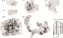
图1
2020年案例区人口密度空间分布
Fig. 1
Population density spatial distribution in the study areas in 2020
本文以社区卫生服务中心为例,检验改进模型进行设施布局规划的可行性。假定每个单元网格均可作为候选设施区位,参考社区卫生服务中心服务能力标准(2018年版)[52],其服务容量按其周边人口密度高低分别设置为9万/km2、7万/km2和5万/km2。针对每一个案例区,探索不同服务半径和覆盖率参数组合,所需某一类服务设施数量、空间位置及所有区位使用服务的平均距离。
4.2 实验结果及分析
本文算法使用Python程序设计,调用CPLEX优化器求解子问题模型。实验计算环境为:HP桌面计算机,配置Intel Core I7-6700 CPU 3.40 GHz、8 GB内存和Windows 10操作系统。安装软件包括Python 2.7、ArcGIS 10.0和IBM CPLEX 12.6优化器。在 ArcGIS中准备案例数据,包括城市基本空间单元及其属性di和si、单元间距离成本cij采用两个单元中心点的直线距离。
具体实验过程为:① 每个案例区采用3组参数:∅ = 1.0 km和μ = 80%;∅ = 1.5 km和μ = 80%;∅ = 1.0 km和μ = 70%;② 考虑到本文算法是随机算法,针对每个案例城市每组参数约束下的设施规划,算法运行5次,获得5个规划方案。规划方案统计见表3,其中设施数量、平均距离、计算时间均为5次计算结果的平均值,设施数量表示规划方案所需设施数量,平均距离为所有区位使用服务的加权平均距离。根据规划方案中供需指派关系,统计不同服务半径所覆盖的需求数量。
表3 不同规划参数(服务半径和覆盖率)约束下服务设施规划结果统计
Tab. 3
| 城市 | 规划参数 | 设施数量 (个) | 平均距离 (km) | 计算时间 (s) | 不同服务半径的人口覆盖率(%) | ||
|---|---|---|---|---|---|---|---|
| < 1.0 km | < 1.5 km | < 2.0 km | |||||
| KF | 22.0 | 0.781 | 622.42 | 80.2 | 92.3 | 96.6 | |
| KF | 10.2 | 1.121 | 1020.90 | 51.3 | 80.5 | 89.7 | |
| KF | 14.8 | 0.979 | 954.28 | 70.4 | 85.3 | 90.9 | |
| LY | 51.2 | 0.743 | 1413.84 | 80.1 | 94.1 | 98.4 | |
| LY | 26.0 | 1.056 | 1858.45 | 52.7 | 80.6 | 93.1 | |
| LY | 37.0 | 0.870 | 1753.85 | 70.1 | 88.4 | 95.4 | |
| PD | 22.2 | 0.719 | 488.09 | 80.5 | 97.5 | 99.8 | |
| PD | 10.4 | 1.037 | 858.92 | 50.7 | 81.4 | 96.0 | |
| PD | 16.8 | 0.823 | 653.43 | 70.8 | 92.9 | 98.8 | |
| ZZ | 61.8 | 0.753 | 2309.47 | 80.1 | 94.4 | 98.0 | |
| ZZ | 48.6 | 0.886 | 1893.68 | 68.7 | 88.2 | 95.0 | |
| ZZ | 49.2 | 0.880 | 2494.25 | 70.5 | 88.6 | 94.9 | |
| SZ | 145.0 | 0.760 | 3514.54 | 80.0 | 93.3 | 97.9 | |
| SZ | 132.2 | 0.848 | 2420.47 | 72.5 | 89.2 | 95.6 | |
| SZ | 133.2 | 0.841 | 2595.73 | 73.1 | 89.6 | 96.1 | |
| SH | 190.0 | 0.695 | 2948.15 | 83.6 | 94.1 | 97.7 | |
| SH | 190.0 | 0.692 | 2724.13 | 83.3 | 94.1 | 97.8 | |
| SH | 188.8 | 0.705 | 2694.96 | 82.8 | 93.5 | 97.4 | |
对于案例区KF,设施服务半径为1.0 km和覆盖率80%时,所需设施数量平均为22.0个,获取服务的平均旅行距离为0.78 km;当增加服务半径约束1.5 km,覆盖率80%保持不变时,所需设施数量降低为10.2个,但平均旅行距离增加为1.12 km;当服务半径为1.0 km,将覆盖率降为70%时,所需设施数量约为14.8个,平均旅行距离为0.98 km。可以看出,该区域规划方案受参数设置影响很大。在人口密度较低的案例区LY和PD,规划实验呈现出与案例区KF相似的特征:规划方案对参数设置极为敏感。
对人口密度较高的案例区ZZ和SZ,对规划参数设置较为敏感。如案例区ZZ,当满足服务半径为1.0 km和覆盖率80%时,所需设施数量为61.8个,获取服务的平均旅行距离为0.75 km;当放松服务半径约束为1.5 km或降低覆盖率为70%时,所需设施数量分别减少为48.6个和49.2个,获取服务的平均旅行距离分别增加为0.89 km和0.88 km。
而对于SH,当满足约束条件服务半径为1.0 km和覆盖率80%时,所需设施数量为190.0个;当满足约束条件服务半径为1.5 km和覆盖率80%时,所需设施数量仍为190.0个;当满足约束条件服务半径为1.0 km和覆盖率70%时,所需设施数量为188.8个。在该区域,给定不同的规划参数,所需服务设施数量和平均服务距离并未发生显著改变,相对容易满足15 min生活圈建设标准。
图2为6个案例区3组规划参数约束下的设施区位和设施服务区示意图。服务设施布局具有两个明显的特征:① 设施分布密度与人口分布密度相一致,呈现城市中心密度高外围密度低的分布特征,城市中心区域需求区位与设施距离较近,而在城市外围地区,需求区位与设施距离相对较远;② 绝大多数设施的服务区空间连续,形状较为紧凑,设施通常位于服务区内人口较为集中的位置。这些特征与规划导则要求相一致,也符合规划人员的实践经验。
图2
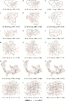
图2
案例区设定不同参数的规划方案
Fig. 2
The planning schemes with different parameters for six study areas
图3
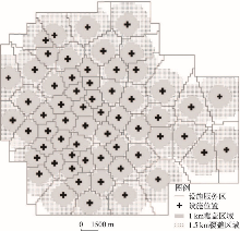
图3
案例区ZZ基层医疗服务设施规划方案
(∅=1.0 km, μ=80%)
Fig. 3
Diagram of a basic medical service facility planning scheme in ZZ
(∅=1.0 km, μ=80%)
表4 案例区ZZ基层医疗服务设施需求覆盖统计
Tab. 4
| 服务半径(km) | 覆盖人口(人) | 总人口(人) | 覆盖人口/总人口(%) |
|---|---|---|---|
| 0.5 | 1293102 | 4223997 | 30.61 |
| 1.0 | 3386895 | 4223997 | 80.18 |
| 1.5 | 4001819 | 4223997 | 94.74 |
| 2.0 | 4154030 | 4223997 | 98.34 |
| 2.5 | 4204061 | 4223997 | 99.53 |
| 3.0 | 4221167 | 4223997 | 99.93 |
验证本文模型的优势,作者使用CFLP和CPMP模型进行设施布局规划,并与本文模型进行比较。以研究区ZZ为例(表5),① μ CFLP模型设置规划参数∅ = 1.0 km和μ =80%,需要设置61个设施,设施1.0 km半径的人口覆盖率为80.00%,居民与设施间的平均距离为0.743 km。② 使用CFLP模型,所需设施数量仅为49个,设施1.0 km半径的人口覆盖率为68.86%,居民与设施间的平均距离为0.846 km。③ 使用CPMP模型,设置设施数量为56个、57个、58个、59个、60个、61个和62个。随着设施数量增加,设施1.0 km半径人口覆盖率从75.76%增加到78.94%,平均距离从0.767 km下降到0.732 km。从表5可以看出,① CFLP、μ CFLP模型选择的设施数量分别为49个和61个,前者设施成本低,但设施1 km服务半径仅能覆盖69%的人口,后者能够满足设施1 km服务半径覆盖80%人口的需求。② 因CPMP模型需要确定设施数量,实际应用中需要设置多个设施数量进行尝试,结果发现按该模型设置56~62个设施,设施1 km服务半径能覆盖75%~79%的人口,仍不能满足设施1 km服务半径覆盖80%人口的需求。③ μ CFLP模型无需指定设施数量,按照规划指标进行布局设施,可平衡服务供给成本和服务可达性,在应用中具有优势。
表5 案例区ZZ服务设施规划:3个区位模型(μ CFLP, CFLP, CPMP)计算结果比较
Tab. 5
| 模型 | 设施数量 (个) | 平均距离 (km) | 计算时间 (s) | 不同服务半径的人口覆盖率(%) | ||
|---|---|---|---|---|---|---|
| <1 km | < 1.5 km | < 2 km | ||||
| μ CFLP | 61 | 0.743 | 4440.40 | 80.00 | 95.31 | 98.63 |
| CFLP | 49 | 0.846 | 2945.44 | 68.86 | 90.44 | 97.05 |
| CPMP | 56 | 0.767 | 2424.77 | 75.76 | 94.67 | 98.56 |
| CPMP | 57 | 0.763 | 2447.36 | 75.74 | 95.30 | 98.92 |
| CPMP | 58 | 0.757 | 3227.06 | 76.74 | 95.29 | 99.05 |
| CPMP | 59 | 0.753 | 3339.92 | 78.03 | 95.13 | 98.76 |
| CPMP | 60 | 0.745 | 3014.18 | 78.06 | 95.24 | 99.05 |
| CPMP | 61 | 0.740 | 2655.39 | 78.94 | 95.27 | 98.77 |
| CPMP | 62 | 0.732 | 2293.94 | 78.54 | 96.17 | 99.17 |
5 结论与讨论
5.1 结论
面向城市15 min生活圈的服务设施规划问题,本文在综合考虑服务半径和覆盖率前提下,首次改进经典的设施区位问题(CFLP)为服务半径和覆盖率双重约束下的部分覆盖问题(μ CFLP),构造μ CFLP线性规划模型,设计了单源CFLP数学启发求解算法。按照中国城市规模划分标准,选择6个典型城市案例区域,以社区卫生服务中心为例,进行服务设施布局规划实验。
案例研究表明:① 改进模型适用于城市生活圈服务设施布局规划,能够平衡服务供给成本和空间公平性,可以弥补现有区位模型的不足;② 与常用CFLP、CPMP模型相比,本文模型在面向15 min生活圈的城市服务设施规划方面具有明显的优势,一是无须事先确定设施数量,二是能够按覆盖半径与覆盖率指标寻找最优设施布局;③ μ CFLP模型计算复杂度较高,较小规模案例区求解时间约为8~17 min,大规模案例需要40~60 min;④ 在人口密度高的大都市,相对容易满足15 min生活圈建设标准,而在人口密度较低的城市,模型对服务半径和覆盖率参数设置敏感,设施布局受参数影响较大。
5.2 讨论
本文模型能够很好地满足国家《“十四五”公共服务规划》提出的要求:人群覆盖,服务达标;均等享有,便利可及;尽力而为,量力而行,适用于生活圈规划中教育、文化、养老、体育、休闲等居民日常需求的公共服务设施布局规划。应用流程大致为:① 采用居住社区或网格作为基本空间单元,通过人口数量与年龄结构预测每个单元的需求数量;② 针对不同类型的服务,参考其设施建设标准,遴选候选区位,并根据设施占地面积、建筑面积、资源配置等指标设置设施的最大服务能力;③ 结合城市人口密度、财政状况,确定设施服务半径和覆盖率等规划参数;④ 应用本文算法求解,获得设施区位和各设施服务区范围,并进行规划方案多种指标计算,用于规划决策。规划参数设置对规划结果影响显著,通常来说,人口密度较高的城市,建议使用规划导则推荐的服务半径(1.0 km),并设定较高的服务覆盖率(如80%~85%);而在人口密度较低的城市,设定较为适中的服务覆盖率(如75%~80%)。在公共财政状况较好的城市,选择相对较好的覆盖率,反之选择相对较低的覆盖率。
本文模型在应用于城市生活圈服务设施规划时,需要详尽、可靠的数据支撑。① 城市空间单元划分要合理,不宜过大或过小;单元过大,不利于规划指标的精细计算;单元过小,数据准备困难,也影响模型计算效率。② 空间单元需求数量的预测需要充分考虑人口数量、年龄结构、区域规划、人口流动等因素。③ 步行时间估算是生活圈服务设施规划一个挑战,很多城市缺乏详细的步行道路网络数据。此外,服务半径和覆盖率约束使设施区位问题求解具有极大的挑战性,本文提出数学启发算法进行求解,计算性能仍有一定的提升空间。同时,现有的规划软件难以适应城市生活圈服务设施布局规划实践。后续的研究工作应当聚焦于算法求解质量、计算效率和应用工具研发。
参考文献
Challenges faced by China in its rapid urbanization process in the near future
我国城镇化高速发展期面临的若干挑战
A study on life circle planning based on space time behavioural analysis: A case study of Beijing
基于时空间行为的城市生活圈规划研究: 以北京市为例
Urban Residential Area Planning and Design Standards(GB50180-2018)
城市居住区规划设计标准(GB50180-2018)
Demand-supply matching oriented 15-minute community life circle demarcation and spatial optimization, Wuhan
基于供需匹配的武汉市15分钟生活圈划定与空间优化
Small neighborhood achieves the big article on city life: The process and practice of the continuous exploration of neighborhood planning in Shanghai
小街区成就城市生活大文章: 上海持续探索街区规划的历程与实践
Research on the configuration difference of public service facilities of 15-minute living circle based on POI:A case study of Wuhan
15分钟生活圈公共服务设施配置差异研究:基于武汉市POI数据分析
Research on the spatial measurement of "15-minute community life circle" in Beijing based on POI
基于POI的北京市“15分钟社区生活圈”空间测度研究
Study on the urban community life sphere system and the optimization of public service facilities: A case study of Qinghe area in Beijing
城市社区生活圈体系及公共服务设施空间优化: 以北京市清河街道为例
Concept, method and practice: An academic discussion on the core meaning analysis of "15-minute community life circle planning"
概念·方法·实践: “15分钟社区生活圈规划”的核心要义辨析学术笔谈
The state council issues on adjusting standards for classifying cities
国务院印发《关于调整城市规模划分标准的通知》
Reconstruction of urban region system in China based on daily life circle
DOI:10.13249/j.cnki.sgs.2005.01.17
[本文引用: 2]

This paper points out that the urban region studied by urban geography has three types. Urban regional system is a synthesis that is composed of geography factors forming the urban region. And it is an organic entirety with different function in the region and complicated structure that is formed by the promotion of productivity and urbanization. The system is an urban function regional one formed by the differentiation and combination of urban region. And the urban regional system is developing, changing, differentiating and integrating all the time. The reasonable urban regional system must have the comparable and functional feature, and the urban statistic must be true. The foreign geographers have studied the foundation of urban regional system for a long period of time. This paper analyses the American Standard Metropolitan Area (SMA) Theory and the Japanese Densely Inhabited District (DID) Theory that are representative and ripe. All these theories can be used by China to reconstruct the urban regional system for reference at the aspect of theory and method. Comparing with foreign study, China has attempted for many times at the aspect of foundation of urban regional system. But some problems of concepts and methods still exist. After the analysis of theory and method about the construction of the pertinent urban region system at home and abroad, the paper points out the subsistent problems in the define of urban region system in China. On the base of analysis of necessity of reconstruction of Chinese urban regional system, this paper puts forward the idea of reconstruction based on daily life circle and defines the concept of daily life circle. From the point of view of inhabitant's individual life, daily life circle is the spatial area that the daily activities of urban inhabitant involves such as inhabitation, work, education, shopping, medical treatment, entertainment and commuting. The daily life circle is a material urbanization region of a city, and it is the spatial shape and structure system that is formed through urban inhabitant fulfills all kinds of activities in the material urban regional system. It is a functional urban regional system including three circles-essential life circle, basic life circle and opportunity life circle. The essential life circle corresponds to the built-up area of city. The basic life circle corresponds to the linking part of town and country. The opportunity life circle corresponds to outskirts of city. The reconstruction uses the method of raster technique. This method realizes that basic spatial unit of urban regional system based on daily life circle can't be confined by the urban district borderline, and can describe the urban developing level objectively. In the last part, the paper discusses the feasibility of construction of Chinese urban regional system based on daily life circle elementarily. The idea of daily life circle can be used to study Chinese urban developing rules from the point of microcosmic view. And it can also provide a new thinking method to frame and accomplish urban planning and management. The idea of daily life circle has important theoretical and practical meaning for the theoretical study and the practice of urban planning for Chinese urban problems.
基于“日常生活圈”的我国城市地域系统的重建
Life circle theory based county public service distribution: Jiangsu Pizhou case
生活圈理论视角下的县域公共服务设施配置研究: 以江苏省邳州市为例
Research on evaluation of urban street regeneration based on public vision: Cases study of Shanghai
基于公众视野的城市街道更新评价研究: 以上海为例
Research on the assessment of age-friendly community
老年友好社区的评价体系研究
A new time-geography research framework of community life circle
DOI:10.18306/dlkxjz.2020.12.001
[本文引用: 3]
Community life circle examines urban communities from the perspective of residents' daily activities. It is the frontier of urban geography and urban related studies. It is also an important part of the innovation of Chinese territorial and spatial planning system and an important starting point for the sustainable development of China's urban society. With the continuous deepening of mobility and informatization, the agents of community life circles, community activities and residents' spatiotemporal behavior, and the function and meanings of community space are becoming more diversified, which needs innovative research and practical guidance of urban social geography. Time-geography is a comprehensive social-technical-ecological approach to understand the relationship between humans and the environment, which provides an essential basis for early research on community life circles based on activity space. New time-geography attaches great importance to the interactions and spatiotemporal combinations of projects between family and other social organizations. It can provide an important basis for the study of the complex interactions between individual, family, and community and the sociocultural constraints, the complex context analysis, and the simulation of spatiotemporal behavior in community life circles. Based on the new time-geography approach, this study proposed a new time-geography research framework of community life circle from theoretical, methodological, and empirical perspectives, including: 1) constructing the community life circle theory based on spatiotemporal behavior and revealing community life circle spatial and temporal structures; 2) developing methods for collecting and analyzing spatiotemporal behavioral data of community life circle and simulation; 3) innovating Chinese urban planning and management from the aspects of optimizing residents spatiotemporal behaviors within the community life circle, community social interaction life circle, and community safety life circle.
社区生活圈的新时间地理学研究框架
DOI:10.18306/dlkxjz.2020.12.001
[本文引用: 3]
社区生活圈从居民日常活动及行为视角考察城市社区,是城市地理学和城市相关学科的研究前沿,也是中国国土空间规划体系创新的重要组成部分,以及中国城市社会可持续发展的重要抓手。伴随着流动性和信息化的不断深入,社区生活圈的主体日益多元化、社区活动和居民时空行为日益多样化、社区空间的功能与意义日益丰富化,亟需城市地理学的研究创新与实践引导。时间地理学是理解人与环境关系的社会—技术—生态综合方法,为早期基于时空行为与生活空间的社区生活圈研究提供了重要基础。新时间地理学重视家庭及其他组织企划的交互与时空组合,可为社区生活圈内个体—家庭—社区之间的复杂互动关系研究、时空行为的社会文化制约与多情境分析及模拟提供重要支撑。论文基于新时间地理学方法,从理论、方法和实证3个维度提出社区生活圈的新时间地理学研究框架,具体包括构建社区生活圈的时空行为理论,揭示社区生活圈的时空间结构;创新社区生活圈的时空行为分析和模拟方法;从社区生活圈时空行为优化、社区交往生活圈、社区安全生活圈等方面创新中国城市规划与管理等研究内容。
Community life cycle public facility configuration study based on demand-supply correlation: A case study of Guangzhou
供需关联视角下的社区生活圈服务设施配置研究: 以广州为例
Assessing the distribution of public service facilities in unit planning based on the perspective of the 15-minute community-life circle: Evidence from Huangpu district of Shanghai
15分钟社区生活圈视角的单元规划公共服务设施布局评估: 以上海市黄浦区为例
Spatial differentiation of public service facilities' configuration in community life circle: A case study of Shahekou district in Dalian city
DOI:10.18306/dlkxjz.2019.11.006
[本文引用: 1]
The level of urban public service provision directly affects the life quality of residents, and location and allocation of urban public service facilities are an important task of urban planning and development. In recent years, the concept of urban life circle has been paid increasing attention to in China, and various localities have aimed to create a perfect "community life circle" as a key task of urban governance. Using the open source map data and the urban network analysis (UNA) toolbox, this study analyzed the spatial difference of public service facilities in Shahekou District of Dalian City, and measured the number and type of reachable facilities to residents of 90 communities in the district. Then, an overall evaluation of each community was conducted. Finally, the optimal allocation of public service facilities was proposed. The results show that: 1) Public service facilities are unevenly distributed in Shahekou District of Dalian City. There are more facilities on the north side and fewer on the south side, showing a structure of one primary center and six secondary centers. The primary center is around the commercial area of Xi'an Road and the secondary centers are distributed in each subdistrict. 2) There is a large difference in the number of reachable facilities to residents—facilities on the north side of the Malan River are more than that of the south side, and there are more facilities in one or two areas in each subdistrict. 3) There are some differences in types of reachable facilities to residents, and more than 70% of the residents can reach all six types of public service facilities. The number of facility types reachable to residents on the west side of Xibei Road-Xinan Road-Wuyi Road is less than that of the east side. 4) Generally, in various communities reachable facilities are balanced and have small differences. However, there are still some communities that show large internal differences. According to the analysis, whether residents can access the various public service facilities is greatly affected by the distribution of facilities, the barriers of ground objects, and the closed degree of community. At the end of this article, we propose to build 15-minute community life circles with all needed facilities and easy to reach.
社区生活圈公共服务设施配置的空间分异分析: 以大连市沙河口区为例
DOI:10.18306/dlkxjz.2019.11.006
[本文引用: 1]
城市公共服务设施的配置水平直接影响到居民的生活品质。论文基于高德地图获取的地图数据,使用城市网络分析工具(Urban Network Analysis Toolbox, UNA)对大连市沙河口区内的6类公共服务设施分布进行空间分异分析,并对区内90个社区的居民出行可达设施的数量及类别进行测度,最后对各个社区进行总体评价。结果表明:① 大连市沙河口区公共服务设施空间分布不均,北多南少,呈现出“一主多次”的“廾”字形的结构,主要分布在西安路商业区周边和各个街道的次级商业区;② 居民可达设施数量空间差异大,北多南少,各街道均有1或2个区域可达设施数量较多;③ 居民可达设施类型数量存在一定差异,70%以上的住宅楼中的居民可以获得全部6类公共服务设施;④ 各社区居民可达设施总体处于差异较小的均衡状态,但仍有个别社区存在内部差异较大的现象。设施的分布、地物的阻隔和社区的封闭程度对居民获取各类公共服务设施影响较大,建议构建“设施完善、便捷可达”的15 min社区生活圈。
Analysis and optimization of 15-minute community life circle based on supply and demand matching: A case study of Shanghai
The 15-minute community life circle (15min-CLC) strategy is one of Shanghai’s important methods for building a global city and facing a society with a more diverse population structure in the future. In the existing research, the balance between the construction of the life circle and the needs of the people in the life circle still needs to be further fulfilled. This paper is based on the city’s multi-source large data set including 2018 AutoNavi POI (Point of Interests), OSM (OpenStreetMap) road network data and LandScan population data set, and evaluates the current status of Shanghai’s 15min-CLC through the fusion of kernel density estimation, service area analysis and other statistical models and proposes relevant optimization suggestions. The results show that there are the following shortcomings: (1) From the perspective of different types of infrastructure service facilities, the spatial construction of Shanghai’s overall life service facilities and shopping service facilities needs to be optimized. (2) From the perspective of comprehensive evaluation, the comprehensive service convenience of infrastructure service facilities in the downtown area is relatively high, while the comprehensive service convenience of urban infrastructure service facilities in the suburbs and outer suburbs is relatively low; The diversity of basic service facilities in the 15min-CLC in the downtown area is more consistent with the population distribution; However, in the peripheral areas of the urban area, too many infrastructure service facilities have been constructed. Based on the above shortcomings and the perspective of supply and demand matching, relevant optimization strategies are proposed in different regions and different types of infrastructure service facilities: (1) focus on the construction of basic service facilities in the urban fringe and urban-rural areas, improve the full coverage of the basic service facilities, and appropriately reduce the number of basic service facilities in the downtown area. (2) The development of community business models can be used to promote the development of new life service facilities and shopping service facilities. (3) Improve community medical institutions through facility function conversion, merger and reconstruction, etc. (4) Optimize the hierarchical basic service facility system and improve the population supporting facilities of basic service facilities in the 15min-CLC. This paper incorporates people’s needs and concerns on the living environment into the 15min-CLC evaluation model, and uses Shanghai as an example to conduct research, summarizes the existing shortcomings, and proposes corresponding optimization strategies based on the matching of supply and demand. This article attempts to explore a replicable 15min-CLC planning model, so that it can be extended to the Yangtze River Delta urban agglomeration, to provide reference for further research on the 15min-CLC, and to promote urban construction under the concept of sustainable development.
Do urban public service facilities match population demand? Assessment based on community life circle
DOI:10.18306/dlkxjz.2021.04.006
[本文引用: 1]
Public service facilities (PSF) are the basic guarantee for urban production and living. Whether the distribution of public service facilities is equitable is related to the healthy development of cities and the society. At present, due to the lack of urban micro-scale population distribution data, there are few studies that consider both the supply side (PSF) and the demand side (population). In view of this, using the Internet maps application programming interface (API), this study established the 5-minute, 10-minute, and 15-minute community life circle of Lanzhou City, and then used Worldpop grid data, population census data, and Baidu heat map data to simulate the population distribution at high spatial resolution and with high accuracy. We evaluated the matching relationships between population and public service facilities in Lanzhou City. The study found that: 1) The matching relationships between different types of PSF and population are very different. However, they show a common phenomenon that the matching degree close to district administrative centers is often better than that of urban fringe. 2) In Lanzhou City, the matching relationships between PSFs and population are highly polarized, that is, there are more highly matched and mismatched life circles, and the number of moderately matched and relatively poorly matched life circles is fewer. 3) Based on the coverage of moderately and highly matched life circles, the coverage of all levels of travel, medical (except community health service centers corresponding to 10-minute life circle), dining, and entertainment facilities is the widest. The allocation of elderly care facilities at all levels and grass-roots cultural facilities is seriously inadequate, and other facilities are between the two types. The study concludes that the problems that have been identified need to be addressed. It suggests that urban planning should focus on the allocation of various PSF in the urban fringe, and improve the coverage of all levels of elderly care facilities.
城市公共服务设施与人口是否匹配? 基于社区生活圈的评估
DOI:10.18306/dlkxjz.2021.04.006
[本文引用: 1]
公共服务设施是城市社会服务最基本的承载体,公共服务设施分配的公平与否,事关城市健康发展和社会公正运行。目前由于城市微观尺度人口数据的缺失,鲜有研究将供给侧(公共服务设施)与需求侧(人口)统一起来。鉴于此,论文以互联网地图API为支撑,建立了5 min、10 min、15 min三个层级的社区生活圈,并模拟了高分辨率、高精度的人口分布图,对案例城市兰州市的公共服务设施与人口的匹配关系进行了详细评估。研究发现: ① 不同类型公共服务设施与人口的匹配关系差异较大,但均表现为区级中心匹配状况较好,城市边缘区域漏配较多;② 兰州市大部分公共服务设施与人口匹配关系两极分化性较强,即高配型与漏配型生活圈数量较多,适配型与低配型生活圈数量相对较少;③ 从中、高匹配度的生活圈的比例来看,各级出行类、就餐类、娱乐类、医疗类设施(10 min生活圈对应的社区卫生服务中心除外)的覆盖范围最广,各级养老类设施和基层文化设施的配置严重不足,其他设施介于两者之间。对于暴露出的问题需要查漏补缺,研究认为,当前公共服务设施规划的重点在于解决养老类设施普及性低和城市边缘区各类公共服务设施配置不足的问题。
The 15-minute walkable neighborhoods: Measurement, social inequalities and implications for building healthy communities in urban China
Creating a senior friendly pedestrian space system from life circle viewpoint
生活圈视角下的住区适老化步行空间体系构建
Assessing spatial disparities of accessibility to community-based service resources for Chinese older adults based on travel behavior: A city-wide study of Nanjing, China
Location-allocation problems
DOI:10.1287/opre.11.3.331
URL
[本文引用: 1]
The calculational aspects of solving certain classes of location-allocation problems are presented. Both exact extremal equations and a heuristic method are presented for solving these problems. Directions for further investigation are also indicated because of the need for methods to shorten the total amount of calculation involved.
Optimum locations of switching centers and the absolute centers and medians of a graph
DOI:10.1287/opre.12.3.450
URL
[本文引用: 1]
The concepts of the “center” and the “median vertex” of a graph are generalized to the “absolute center” and the “absolute median” of a weighted graph (a graph with weights attached to its vertices as well as to its branches). These results are used to find the optimum location of a “switching center” in a communication network and to locate the best place to build a “police station” in a highway system. It is shown that the optimum location of a switching center is always at a vertex of the communication network while the best location for the police station is not necessarily at an intersection. Procedures for finding these locations are given.
The maximal covering location problem
DOI:10.1111/(ISSN)1435-5957 URL [本文引用: 1]
Integer programming: methods, uses, computation
DOI:10.1287/mnsc.12.3.253
URL
[本文引用: 1]
This paper attempts to present the major methods, successful or interesting uses, and computational experience relating to integer or discrete programming problems. Included are descriptions of general algorithms for solving linear programs in integers, as well as some special purpose algorithms for use on highly structured problems. This reflects a belief, on the author's part, that various clever methods of enumeration and other specialized approaches are the most efficacious means existent by which to obtain solutions to practical problems. A serious try at gathering computational experience has been made—but facts are difficult to uncover.
An extended theorem for location on a network
DOI:10.1057/jors.1967.73 URL [本文引用: 3]
How to allocate network centers
DOI:10.1006/jagm.1993.1047 URL [本文引用: 2]
Capacitated covering models
DOI:10.1068/b150153 URL [本文引用: 2]
Multicommodity distribution system design by benders decomposition
DOI:10.1287/mnsc.20.5.822
URL
[本文引用: 2]
A commonly occurring problem in distribution system design is the optimal location of intermediate distribution facilities between plants and customers. A multi-commodity capacitated single-period version of this problem is formulated as a mixed integer linear program. A solution technique based on Benders Decomposition is developed, implemented, and successfully applied to a real problem for a major food firm with 17 commodity classes, 14 plants, 45 possible distribution center sites, and 121 customer zones. An essentially optimal solution was found and proven with a surprisingly small number of Benders cuts. Some discussion is given concerning why this problem class appears to be so amenable to solution by Benders' method, and also concerning what we feel to be the proper professional use of the present computational technique.
Location Problems in the Public Sector
Measuring the spatial accessibility of public services by optimal supply-demand allocation
DOI:10.11821/dlxb202204017
[本文引用: 1]
Spatial accessibility is an important index for measuring fairness in public services such as health care, education, and outdoor leisure. It has also been widely used in the layout planning of public facilities. However, the existing accessibility models cannot fully illustrate the direct relationship between service supply and demand, and thus, the accessibility indicators cannot be explained with explicit meanings. This article introduces a new method for measuring accessibility based on optimal supply and demand allocation, which is different from the supply-demand relationships in existing methods. Given the supply locations, the demand locations, their attributes, and the travel costs between them, the transportation problem model is used to allocate services to demands. The classical model can be easily solved with optimal total travel cost. Based on the model results, the spatial accessibility of services can be measured. The proposed method was tested on healthcare services in a district in Zhengzhou, Henan, China. There were 25 healthcare centres and 1333 residential communities in the study area. The instance model was effectively built by an open-source MIP solver in 2.2 seconds. The service area of each healthcare centre and the travel time from each community were obtained according to the modelling results. In addition, the coverage percentages with predefined service thresholds were calculated. The proposed method was also compared with popular methods, such as the two-step floating catchment area method (2SFCA), Gaussian 2SFCA, and gravity 2SFCA. Areas with poor healthcare services were identified by using the results from the three 2SFCA methods. However, the spatial variation in service accessibility might be very different when selecting different search thresholds and/or distance decay coefficients. The optimal supply-demand accessibility method (OSD) proposed in this study has advantages such as being parameter-free, easy to calculate, and easy to explain. The authors believe that the method has application potential to replace the existing methods in evaluating public services and facility planning.
基于最优供需分配的公共设施空间可达性分析
DOI:10.11821/dlxb202204017
[本文引用: 1]
空间可达性是衡量公共服务设施公平性的重要指标,在医疗、教育、休闲等公共服务的布局规划中得到广泛应用。然而已有设施服务可达性模型难以充分反映服务供需关系,计算指标也缺乏物理意义。本文提出新的最优供需分配的公共设施空间可达性计算方法(OSD)取代现有方法。该方法基于最优供需分配模型,将设施服务分配给需求者,根据分配结果计算空间可达性指标。给定服务设施与需求的空间分布,以最小化旅行成本为目标,顾及设施服务能力,采用经典的运输问题模型确定最优的服务供需分配方案,进而度量服务的空间可达性。以郑州市金水区社区卫生服务为例,求解25个中心与1333个居住小区的最优服务配置。使用最优配置结果确定每个设施的服务范围、每个居住小区使用服务的旅行时间,以及特定时间阈值的服务覆盖比率。与流行的两步移动搜索法相比,新方法的计算指标具有明确的物理意义。本文提出的可达性评价方法无需参数,计算高效,结果易于解释,在公共服务评价及设施布局规划方面具有应用潜力。
A center-based modeling approach to solve the districting problem
DOI:10.1080/13658816.2018.1474472 URL [本文引用: 1]
A taxonomy for emergency service station location problem
DOI:10.1007/s11590-011-0376-1 URL [本文引用: 1]
Facility location optimization model for emergency humanitarian logistics
DOI:10.1016/j.ijdrr.2017.01.017 URL [本文引用: 1]
A method to improve the resilience of multimodal transport network: Location selection strategy of emergency rescue facilities
Resource allocation and location decision of a UAV-relay for reliable emergency indoor communication
DOI:10.1016/j.comcom.2020.05.019 URL [本文引用: 1]
Application of the P-Median problem in school allocation
DOI:10.4236/ajor.2012.22030 URL [本文引用: 1]
Two new location covering problems: The partial P-center problem and the partial set covering problem
The fixed charge facility location problem with coverage restrictions
DOI:10.1016/S1366-5545(00)00018-1 URL [本文引用: 1]
A large-scale application of the partial coverage uncapacitated facility location problem
DOI:10.1057/palgrave.jors.2601469 URL [本文引用: 1]
Approximation algorithms for partial covering problems
DOI:10.1016/j.jalgor.2004.04.002 URL [本文引用: 1]
A matheuristic algorithm for the single-source capacitated facility location problem and its variants
Heuristics for the capacitated plant location model
DOI:10.1016/0377-2217(83)90195-9 URL [本文引用: 1]
Standard of service capacity of community health service centers (2018 edition)
2018-08-22.http://www.nhc.gov.cn/jws/s7882/201809/d77cd05877b84909b0bd0e8b92a3e5f8.shtml, 2018-08-22.
社区卫生服务中心服务能力标准(2018年版)
http://www.nhc.gov.cn/jws/s7882/201809/d77cd05877b84909b0bd0e8b92a3e5f8.shtml, 2018-08-22.]
