

1 引言
受全球自然和社会环境急剧变化的影响,面对气候变化、传染病疫情肆虐、经济波动等对人类社会的一次次巨大冲击,人们对自身应对能力和恢复能力开始关注和重视。联合国可持续发展目标(SDGs)明确提到要在2030年前以综合方式彻底解决社会、经济和环境3个维度的问题,为人类提供一个包容、安全、有风险抵御能力和可持续的人类社区。中国共产党“二十大”报告中强调要统筹乡村基础设施和公共服务布局,建设宜居宜业和美乡村。2023年中央一号文件指出要扎实推进农村人居环境整治提升。中国共产党第十九届五中全会发布的《中共中央关于制定国民经济和社会发展第十四个五年规划和二〇三五年远景目标的建设》中明确指出要健全城乡融合发展机制,优先发展农业农村,改善农村人居环境,全面推进乡村振兴。在中国城乡融合和乡村振兴的大背景下[1-2],乡村作为人类社区的主要形式之一,经济发展水平较低、公共基础设施不完善、环境管控力较弱,易受到各种内外扰动,影响人居环境的可持续发展,面临重大转型[3-4]。如何通过科学解析乡村人居环境弹性形成的特征和内在机理,破解乡村人居环境整治研究与实践的重点难点,助力乡村人居环境质量的提升,既契合时代需要,服务国家战略,也是实现城乡融合,助力乡村振兴的重要路径[5]。
弹性的概念由Holling引入生态学,并发表了关于生态弹性的论文,此后弹性概念越来越受到国际学术界的广泛关注[6],认为它能跨学术、理论、政策和实践,具有很强的可塑性[7]。进入21世纪,针对乡村弹性的研究逐渐兴起。Heijman等指出乡村弹性是乡村地区在保持生活条件不变的前提下,通过乡村系统内部生态、经济和社会的响应与协调,吸收外界环境变化的能力[8]。已有研究从乡村人[9-10]、乡村地[11]、乡村社会[12-13]、乡村经济[14]等多方面来综合评价中国的乡村弹性水平[15-16],以提高乡村发展的活力和乡村防灾减灾等方面的能力。新时期乡村人居环境的要求越来越高,人居建设与社会进步的目标逐步统一起来,各种设施的建设无不源于美好的人居环境与和谐社会的基本要求[17],而乡村人居环境弹性既重视人居硬环境的建设,也关注人居软环境的协调[18-19],契合当下乡村人居环境的需求,可推动乡村可持续发展[20],是乡村弹性的重要内容之一。
纵观国内外针对乡村人居环境弹性形成的研究进展,从研究内容上,弹性形成的影响因素和区域特征被较多学者关注。人类活动、气候变化、社会分异等会增大乡村脆弱性[21-22],影响弹性形成,如大规模的人类活动可以改变区域微气候,工业污染可以使降水减少,城市盲目扩张、森林砍伐等会导致土壤侵蚀的加速[23⇓-25],极端事件的发生、农村空心化、人口外流、老龄化等问题会影响乡村人居环境的公共秩序[26],使乡村社会分异现象加剧[27-28],过度的乡村旅游开发将导致农村的传统文化和自然基底被破坏等[29⇓⇓-32]。不同地区需要针对不同的特征解析,来抑制其带来的不良影响,如在邻近河流湖泊和位于三角洲的乡村地区,需要用更强大的堤岸和抽水系统,以应对气温升高、洪涝灾害等;在地震、台风、泥石流等多发区域,强调用更健全的疏散计划和防灾避难场所来降低或避免受灾的可能[33-34]。从研究方法上,为了拓展乡村人居环境弹性研究的广度和深度,从单一的定性研究发展到综合研究,广泛地运用地理计量的方法和技术手段[35-36]。从研究范围上,单一的县域村镇研究已不能满足需求,从而逐步扩展到相对复杂的城乡复合系统,把握乡村人居环境弹性在不同地域范围内的驱动和形成机制[37]。同时,部分学者还结合建筑学、规划学等方面的内容研究人居环境弹性[38-39],研究成果有助于对乡村人居环境进行因地制宜的分类施策和设计规划[40-41],把握提升乡村人居环境弹性,创造更加包容、稳定的乡村。
综上所述,乡村人居环境弹性是乡村弹性的重要研究内容之一,相关研究成果为乡村人居环境的质量提升打开了新的思路,契合当下乡村发展的新趋势,为中国特色的乡村人居环境提供了丰富的理论和实践基础[42-43],但现有研究仍然存在不足:① 由于“弹性”被多学科泛用[44],乡村人居环境弹性的内涵界定不明晰,尤其在城乡融合的背景下,如何区分城市人居环境弹性和乡村人居环境弹性,同时又不能忽视二者之间的关联性。② 乡村人居环境弹性形成的内在机理未完全厘清,缺乏从多因素去分析乡村人居环境弹性形成的驱动机制[45]。③ 由于区域发展存在明显的空间差异[46],基于一些特定类型区域的探讨较少,迫切需要由小及大、由点及面,进行不同地域类型的划分,重点剖析各地域类型区的人居环境优化路径。基于此,本文运用弹性的理念,结合乡村人居环境发展的多源数据,重点剖析洞庭湖区乡村人居环境弹性形成的演化规律,测度乡村人居环境弹性形成指数,识别其形成机制,为乡村人居环境弹性形成的演变过程以及干预措施研究提供参考借鉴,以期为中国乡村人居环境发展提供基础性研究成果,提升乡村人居环境的质量。
2 乡村人居环境弹性形成理论框架
乡村人居环境是城乡复合人居环境系统中不可分割的组成部分,也是乡村人地关系的综合体现,其与城市进行合作和功能整合,起着维护乡村居民活动所需的物质和非物质结构的有机结合体的功能。结合中国的制度、经济和文化背景与区域城乡发展环境,将弹性的概念引入并运用到乡村人居环境建设中。乡村人居环境弹性是指乡村人居环境系统发生内外扰动时,能够由内及外的对抗各类扰动,在对抗的过程中激发活力、不断适应,维持系统内部的平衡,并通过一次次的扰动增强自身的抵抗力,推进系统由低层次向高层次的演化。乡村人居环境的弹性形成将有助于乡村人居环境的良性发展,解决“三农”问题和破解城乡二元结构等,提高乡村人居环境的整体质量,避免在气候变化、各类极端事件等不良影响发生时人居环境将面临的混乱。
乡村人居环境弹性形成不是自然形成的结果,需要遵循规划的原则,在弹性形成的不同阶段,灵活地调整规划,以保证弹性形成的稳定性。面对各方需求,以规划为指导,设计和管理分别对应乡村人居硬环境和软环境。改造设计乡村人居环境的设施设备,提高硬环境抵御风险的适应度;协调提升乡村现代化管理水平,增强软环境面对风险的反应度。因此,乡村人居环境弹性的形成机制可从规划、设计和管理3个维度推进,并分别对应评价指标体系中的灵活性、适应性和反应度,使乡村人、乡村经济、乡村生态和乡村工程在发展的过程中,抑制对乡村人居环境发展不良因素的影响,增强系统内部活力,在乡村自然和社会环境遭到内部和外部的破坏、下降和扰动时,不断的调整、适应、学习、演变和转型,形成弹性,并向更开放、公平、包容和可持续的方向发展(图1)。
图1
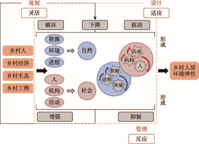
图1
乡村人居环境弹性形成框架示意图
Fig. 1
Framework diagram of the formation of rural human settlements
乡村人居环境弹性形成过程主要分为3个阶段:不受影响范围、可恢复范围和状态发生变化范围(图2)。在整个形成过程中,“开始暴露在各种风险中”和“状态发生改变的阀值”为弹性形成机制中重要的两个阀值点,如果具备抵御能力、恢复能力和学习能力,则会形成预防机制、适应机制和转变机制,系统呈现增长的状态,反之,则停滞逐而衰退。
图2

图2
乡村人居环境弹性形成阶段示意图
Fig. 2
The stage diagram of the formation of rural human settlement resilience
(1)不受影响范围。在乡村人居环境弹性形成的第一个阶段,区域范围内经济发展以农业为主,乡村社会结构相对简单,流动人口少,受到的内外部干扰少,扰动源单一,无论是自然不可抗力还是人为极端事件的扰动,其发生的频率和影响都在人居环境系统可以承受的范围内。内在结构属性和特征功能可以正常运转,人居环境的发展处于被动适应阶段,防御机制和预防能力可以应对冲击较小的扰动,处于封闭或半封闭状态。此阶段,弹性值处于初级阶段,系统流动性和开放性越小,则形成弹性的可能性越小,反之则趋于或突破临界点0。
(2)可恢复范围。随着乡村社会经济的发展,人口的流动越来越大,乡村开放程度越来越高,系统受到的扰动振幅也随之提高,扰动源趋向多元化,包括人为极端事件、气候变化、公共基础设施超负荷、土地退化、生态环境破坏、疾病蔓延、城市盲目扩张下的乡村地域空间萎缩等,甚至同一乡村地域人居环境系统可能同时遭受多种扰动源的干扰。此阶段,系统不得不被动开放,提高流动性,以释放各类扰动带来的压力,但随之而来的脆弱性和易损性也会提高,系统完全暴露在各种风险中,弹性值介于0~1区间,因扰动的不断变化,和适应能力的滞后性,弹性值可以回到0以下,但还是会重复面临不可知的扰动,并在临界值1以下反复波动,不利于系统的可持续发展。反之,如果内部系统恢复能力和适应机制开始启动,能逐渐调整适应,并利用工程化和技术性手段进行干预,则可能突破临界值1,进入发生变化阶段。
(3)状态发生变化范围。随着乡村人居环境系统的不断发展,弹性值突破临界值1,与乡村人居环境系统密切相关的人口、社会、经济、生态等影响因素都发生了变化,此阶段系统变化将出现3种可能:增长(> 1)、停滞(= 1)和衰退(< 1)。如果在外界不断扰动下,乡村人居环境系统内部不适应调整,将在短时间内出现停滞,暴露在风险中的因素增加,脆弱性加剧,系统将会出现衰退。反之,如果内部通过提高学习能力不断调整,科学认知乡村人居环境系统的发展过程和规律,系统自我调控能力提高,则实现增长,形成弹性。
3 研究区域与分析方法
3.1 研究区域概况
洞庭湖区位于长江中游以南,湖南省北部,以洞庭湖为核心,是长江经济带的重要节点,在行政区划上主要包括岳阳、常德和益阳3市,并确定24个县(县级市、县级区,简称县市区)作为主要研究区域,分别为石门县、澧县、津市市、临澧县、桃源县、安化县、安乡县、汉寿县、桃江县、鼎城区、武陵区、南县、华容县、沅江市、赫山区、资阳区、湘阴县、汨罗县、岳阳楼区、云溪区、君山区、岳阳县、临湘市、平江县。2020年该区常住人口1417.48万人,其中乡村人口620.51万人,占该区总人口的43.8%,占湖南省农村总人口的13.3%,乡村居民人均可支配收入为18260元,仅为该区城镇居民人均可支配收入的51.7%,是非常典型的农区(图3)。近年来,该地区城镇化快速发展,农村劳动力转移、城乡居民消费结构失衡,乡村“拆村并点”“千篇一律”的建设、农业污染和生活污染等问题日益突出,气候变化使得农业自然灾害加重,尤其是江湖关系变化导致的洪涝威胁仍然存在,乡村人居环境问题凸显。其地理环境、区域地位、社会经济条件和主体功能属性等决定了其人居环境的典型性和复杂性,迫切需要从内部机制和未来发展路径上加以调控引导,提升该区乡村人居环境弹性。
图3
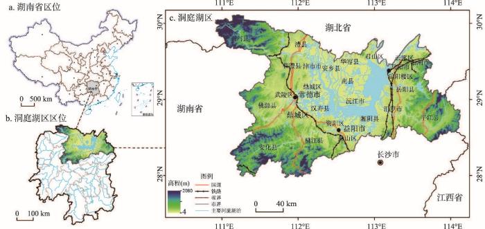
图3
洞庭湖区区位
注:基于自然资源部标准地图服务网站审图号为GS(2019)1823号的标准地图制作,底图边界无修改。
Fig. 3
The location of Dongting Lake area
3.2 分析方法
3.2.1 乡村人居环境弹性形成评价指标体系构建
基于对国内外相关研究的梳理、归纳和总结,研究区的实地调研,结合联合国开发计划署发布的《Resilient: Zero-Carbon, Risk-Informed, Sustainable》报告中关于人类住区建设的部分内容[47],以及中国住房城乡建设部印发的《中国人居环境奖评价指标体系》(2016)的相关内容,和吴良镛的《人居环境科学导论》中的相关理论[48],乡村人居环境弹性形成指数(Resilience Human Settlement Formation Index, RHFI)的评价指标体系从灵活性(Human Settlement Resilience Flexibility, HRF)、反应度(Human Settlement Resilience Reactivity, HRR)和适应性(Human Settlement Resilience Adaptability, HRA)3个方面展开,具体包括15项指标,下设19个具体要素(表1)。
表1 乡村人居环境弹性形成评价指标体系
Tab. 1
| 准则层 | 指标层 | 要素 | 权重 |
|---|---|---|---|
| 灵活性HRF (0.331) | 交通可达度 | 等级公路里程 | 0.052 |
| 生活便捷度 | 乡村超市数量 | 0.049 | |
| 农村电商普及率 | 0.041 | ||
| 基础服务设施 | 文化体育场所数量 | 0.045 | |
| 生活垃圾无害化处理率 | 0.044 | ||
| 通讯设施设备 | 农村移动网络覆盖率 | 0.041 | |
| 乡村居住条件 | 农村居民人均住房面积 | 0.060 | |
| 反应度HRR (0.347) | 乡村治理能力 | 乡村政务办结率 | 0.062 |
| 乡村邻里关系 | 村庄治安环境等级(平安指数) | 0.058 | |
| 乡村产业结构 | 第二三产业产值占比 | 0.063 | |
| 农民生活水平 | 农村居民人均可支配收入 | 0.068 | |
| 乡村经济水平 | 人均地区生产总值 | 0.056 | |
| 适应性HRA (0.322) | 节能减排 | 农业机械总动力 | 0.049 |
| 防灾减灾和应急 | 防灾减灾和应急场所数量 | 0.061 | |
| 乡村社会福利 | 基本养老保险覆盖率 | 0.048 | |
| 基本医疗保险覆盖率 | 0.051 | ||
| 乡村产业发展水平 | 农林牧渔总产值 | 0.053 | |
| 乡村教育医疗水平 | 九年义务教育在校学生数 | 0.050 | |
| 卫生院技术人员数 | 0.049 |
(1)灵活性体现乡村人居环境弹性形成过程中应对外界干扰和内部适应调整的灵活性程度。灵活性测度选取了交通可达度、生活便捷度、基础服务设施、通讯设施设备和乡村居住条件5项指标,在乡村受到外界干扰时,交通可达度反映系统内部是否有完整顺畅的交通网络,及时排解压力,加速人口流动。生活便捷度可为区域内居民提供基本生活供给,维持区域内的社会稳定。基础服务设施为社会生产和居民生活提供公共服务的物质工程设施,保证区域内社会经济活动的正常进行,以及能否在短期内实现自给自足。通讯设施设备是系统连接内外的主要方式之一,通讯网络越发达畅通,则与内外沟通越紧密,越能灵活应对。
(2)反应度体现乡村人居环境弹性形成过程中应对干扰时的反应灵敏程度。反应度测度选取了乡村治理能力、乡村邻里关系、乡村产业结构、农民生活水平和乡村经济水平。乡村治理能力强,邻里关系和谐,产业结构合理,经济发展水平高,则应对风险的能力越强,反应度也越灵敏,能够快速抵御,保持内部的稳定。
(3)适应性体现乡村人居环境弹性形成过程中在干扰发生时或结束后的适应调整程度。适应性反映测度选取节能减排、防灾减灾和应急、乡村社会福利、乡村产业发展水平和乡村教育医疗水平。适应性一般体现在扰动中和扰动后,既有被动的适应,也有主动的适应。如果只是被动适应,则扰动对系统内部的破坏越强,而主动适应调整扰动,则系统遭到的破坏越小。节能减排设施的广泛应用,防灾减灾和应急设施的覆盖率高,乡村社会福利稳定、教育水平高,医疗卫生设施完善,则调整适应速度快,系统适应不可预见风险的能力越强。
3.2.2 数据标准化及权重确定
考虑到指标原始数据间的性质差异和单位数量等影响,选用Z-score数据标准化处理方法,此方法适用于在最大值和最小值未知或有超出范围的离群数据情况下。表1中所有指标均为乡村人居环境弹性形成的正向指标,因此设定公式为:
式中:
由于在乡村人居环境弹性形成的过程中,每一个指标之间都有关联性,且指标之间的共线性强弱大小不一,因此本文运用独立性权重法来考虑指标之间的相关性强弱,并运用回归分析得到各指标的共线性强弱,共线性越强,说明指标信息数据有较大重叠,权重会越低,反之则越高。
3.2.3 乡村人居环境弹性形成指数的测算
通过对获得的三级指标数据进行导入和压缩,权值初始化后,分别从灵活性、反应度、适应性3个方面中选择最优匹配的指标,基于构建的乡村人居环境弹性形成指标体系及各权重值,运用乡村人居环境弹性形成指数公式(2),分别测算洞庭湖区乡村人居环境弹性形成指数:
式中:n表示地区总数;s表示研究时段总数;i表示样本县域乡村;t表示具体时间段;RHFI为乡村人居环境弹性形成指数;HRF为灵活性,HRR为反应度,HRA为适应性。α、β、γ分别为灵活性、反应度和适应性的权重。
3.2.4 乡村人居环境弹性形成的评定分级
根据前文提到的乡村人居环境弹性形成的3个阶段,结合自然断点法,将洞庭湖区乡村人居环境弹性形成划分为3个层级:未形成、正形成和已形成。分别对应5个区:低值区、较低值区、中值区、较高值区和高值区。不同值区体现弹性形成过程中各个县市区的差异,并应用到洞庭湖区乡村人居环境弹性形成分级中(表2)。
表2 洞庭湖区乡村人居环境弹性形成分级标准
Tab. 2
| 分级 | 弹性形成RHFI | 灵活性HRF | 反应度HRR | 适应性HRA | |
|---|---|---|---|---|---|
| 未形成 | 低值区 | < 0 | <0.301 | < 0.277 | < 0.305 |
| 正形成 | 较低值区 | 0~0.297 | 0.302~0.348 | 0. 278~0.377 | 0. 306~0.414 |
| 中值区 | 0.298~0.406 | 0.349~0.472 | 0.378~0.491 | 0.415~0.499 | |
| 较高值区 | 0.407~0.664 | 0.473~0.628 | 0.492~0.603 | 0.500~0.661 | |
| 已形成 | 高值区 | ≥ 0.665 | ≥ 0.629 | ≥ 0.604 | ≥ 0.662 |
3.3 数据来源
乡村人居环境弹性形成指标体系中涉及的相关数据主要来源于以下两类:
(1)一般社会经济数据主要来源于市县乡(镇)统计部门,同时查阅2010—2020年各级政府国民经济和社会发展统计公报,《湖南省农村统计年鉴》《中国县域统计年鉴》《中国电子商务报告》、中国农村数据库等。这部分数据主要为等级公路里程、乡村超市数量、农村电商普及率、文化体育场所数量、生活垃圾无害化处理率、农村移动网络覆盖率、农村居民人均住房面积、第二三产业产值占比、农村居民人均可支配收入、人均地区生产总值、农业机械总动力、基本养老保险覆盖率、基本医疗保险覆盖率、农林牧渔总产值、九年义务教育在校学生数、卫生院技术人员数。
(2)特殊数据为力求准确,通常为实地调研过程中,对村民代表、乡村能人、村镇干部的走访、访谈和座谈会形式获取,通过集体讨论会的方式,由论文研究者通过告知研究目的,逐项解释指标内涵,村民代表和村镇干部集体讨论、达成共识后最后确认。其中乡村政务办结率主要依据24个县市区处理乡村事务办结率,选取的数据为2010—2020年,常德市和益阳市两地已在2020年实现了互联网政务服务办理,因此2020年的数据可以通过一网通获取,但其余年份的数据需通过特殊数据获取方式来获取。防灾减灾和应急场所数量主要通过湖南省、岳阳市、常德市、益阳市的防灾减灾工作调研报告以及相关规划说明等;村庄治安环境等级(平安指数)依据全国通用的平安指数等级获取得分,综合得分90分以上的(含90分)为优秀,85~90分的(含85分)为良好,80~85分的(含80分)为平稳,80分以下的为预警。
4 结果与分析
4.1 洞庭湖区乡村人居环境弹性形成的空间特征
按照本文确定的洞庭湖区24个县市区,通过测算辨别不同区域乡村弹性形成的主要影响因素,结合县域现状,进行空间差异特征的分析。为保证结果的有效性和可比性,本文在空间尺度分析中采用反距离权重法(Inverse Distance Weighting, IDW)。选取的洞庭湖区24个县市区的弹性形成指数、灵活性指数、反应度指数和适应性指数,用像元尺度变化分析将像元大小设定为100 m进行空间插值分析,并对精度进行统计。各指数空间插值存在一定的变化,虽幅度不大,但仍能很明显的看到洞庭湖区乡村人居环境弹性形成指数的变化(图4)。
图4
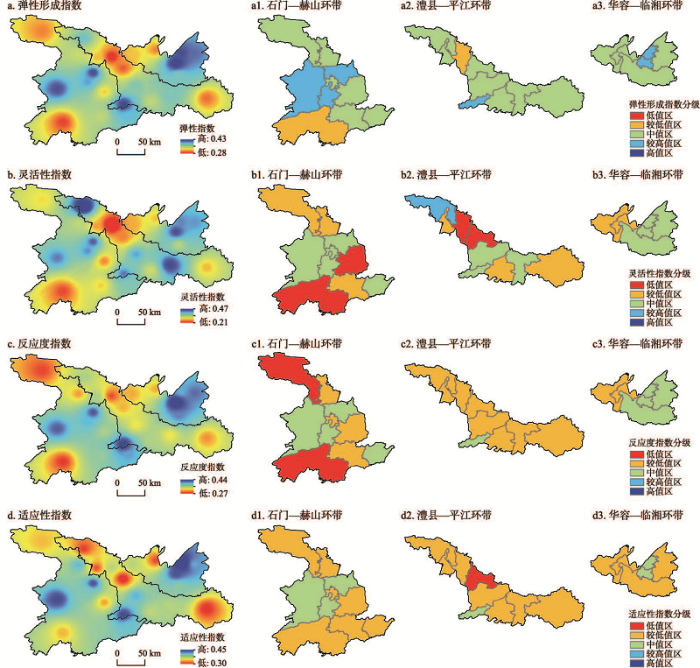
图4
2020年洞庭湖区乡村人居环境弹性形成指数空间插值分异
Fig. 4
Spatial inverse distance weight of rural human settlement resilience formation in various ring belts of Dongting Lake area
(1)弹性形成:洞庭湖区RHFI均值为0.358,根据表2中关于弹性形成的分级标准,显示有24个县市区的人居环境弹性都正在形成中,但普遍偏低,按照前文分级标准来划分,5个处于较高值区,17个处于中值区,2个处于较低值区,中值区占比最高,为70.8%。按照地级市来比较,岳阳的弹性形成值最高,且略微超过了洞庭湖区乡村人居环境弹性形成均值。从空间格局上,呈现出离湖区越远的弹性形成值越低,离湖区越近弹性形成值越高的空间分异特征。
(2)灵活性:洞庭湖区HRF均值为0.359,24个县市区中有4个处于指数低值区、8个较低值区、11个中值区和1个高值区。岳阳市的灵活性指数均值较高,为0.365。岳阳北临长江,辖区内大部分县市区与洞庭湖交错分布,江湖交汇,京广高铁、京港澳高速公路、杭瑞高速公路等交通主动脉在区内交织,港口资源丰富,通江达海,综合交通非常便利。灵活性均值最低的为益阳,益阳虽然紧邻湖南省省会长沙,并有多条高速公路在辖区内交汇,但是多条高速公路老旧,且道路路面狭窄,交通拥堵指数较高等现状,直接降低了交通的通达性,也影响了其灵活性指数。
(3)反应度:洞庭湖区HRR均值为0.346,高于设定的反应度界值0.277,有2个县市区为低值区,22个为正在形成中,其中14个县市区的反应度处于较低值区,占到了总数的58.3%。其余8个县市区虽然反应度指数处于中值区,但指数值总体仍偏低,说明整个洞庭湖区面对外界和内部扰动时,反应度普遍较低。反应度主要选取农村经济相关的指标,并结合了部分社会因素。各指标值与反应度指数的高低成正相关关系,可见经济对反应度指数影响很大。
(4)适应性:洞庭湖区HRA均值为0.372,高于适应性指数形成的界值0.305,正在形成适应性的县市区为23个,占到了总数的95.8%,但较低值县市区占多数,有19个。适应性指数最高的为岳阳市,9个县市区的适应性均值为0.375,都超过了适应性指数的界值范围,且超过了整个洞庭湖区的均值。其次为常德和益阳,均值为0.367和0.363,其中益阳市紧邻省会长沙,农村迁出人口数量占比高,流动大,人口呈负增长,其中南县的适应性值为0.304,处于洞庭湖区最低值,该县无论是地理位置还是社会经济发展等因素都处于较弱的位置。
4.2 乡村人居环境弹性形成呈环带
根据前文所述,综合考虑自然条件、社会经济条件和资源禀赋,围绕与洞庭湖区水域的远近距离,本文将洞庭湖区24个县市区分成3个环带(图5):① 华容—临湘环带,主要包括华容县、岳阳楼区、云溪区、君山区、岳阳县、临湘市共6个县市区;② 澧县—平江环带,主要包括澧县、津市市、安乡县、南县、沅江市、资阳区、湘阴市、汨罗市和平江县共9个县市区;③ 石门—赫山环带,主要包括石门县、临澧县、鼎城区、武陵区、汉寿县、桃源县、安化县、桃江县、赫山区共9个县市区。
图5
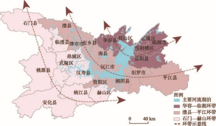
图5
洞庭湖区环带划分示意图
Fig. 5
Schematic diagram of ring belts division in Dongting Lake area
(1)华容—临湘环带。此环带离洞庭湖最近,且大部分县市区都濒临水域,受到江湖干扰等自然环境的影响较大,但东西两岸差距并不显著,围绕着洞庭湖成半环状。同时由于得天独厚的湖泊资源,农业生产充分发挥了洞庭湖的优势,可保障该区农业生产功能,并基本能够实现系统内部的良性循环、自给自足。同时该区还注重提高农业附加值,开展乡村旅游、生态旅游等,吸引农民在本地就业,构建良好的生态格局,保护本地农村的文化基因,实现各方的良性互动,为该区乡村人居环境弹性的形成提供了较好的基础。
(2)澧县—平江环带。除灵活性指数外,该环带的弹性形成指数、反应度指数和适应性指数在3个环带中均处于最低,该区自然基底相对其他两个环带更复杂,河湖网络在该区交错,是典型的传统农区,但耕地利用效率不高,化肥、农膜、农药等农业生产要素在经济发展的盲目驱动下存在不同程度的增加,城镇化与工业化带来的面源污染,乡村水土环境遭到破坏,乡村主体老弱化、农村空心化、基础设施落后等问题突出,直接影响了人居环境各功能的发挥。灵活性指数虽在3个环带中均值最高,但若人口持续外流,则会制约该区乡村人居环境的可持续发展。
(3)石门—赫山环带。该环带的弹性指数中等,其中适应性指数均值为3个环带中最高,从空间距离来看,该区处于洞庭湖区的最外围,区域空间发展受到洞庭湖区的影响最弱,相对而言,该区农业基础条件较好,虽经济发展整体水平不高,但能实现基本的自给自足,适应力相对较强。该区最低的为灵活性指数,交通等基础设施还不够完善,但随着常益长高铁的开通,将吸引大批资本和劳动力的涌入,城乡要素流动将加快,灵活性指数提高的同时也会使得该区乡村人居环境的整体发展环境趋好,从而加快弹性的形成。
4.3 乡村人居环境弹性形成机制剖析
(1)乡村人居环境内源性和外源性的变化是驱动其弹性形成的先导因素,两者相互影响,使得传统的乡村人居环境出现突变、延续或转型等状态,从而形成或不能形成乡村人居环境弹性(图6)。在城乡融合和乡村振兴发展的背景下,人为或自然的干预及扰动,会将资本、技术、人口等要素流动或传递到乡村地区,这些要素既会给乡村人居环境发展带来机遇,同时也会带来持续的扰动或冲击。资本的流入将会为洞庭湖区乡村人居环境的发展提供物质的保障,促进乡村产业的发展,比如渔业、种植业、旅游业等。但仅仅只靠外来资本推动还不够,还需要为该区乡村产业发展注入更多活力,比如生产高附加值的水产品,打造地方特色的乡村旅游产品等,使得资本下乡为农业输血、造血,真正实现乡村内部效益的提升。技术的支持一方面可以提升农业生产的能力,另一方面也可使得该区抗自然灾害、江湖灾害等扰动的能力提高。人口要素的流动会带来人口的流失,加剧乡村老弱化,社会组织和结构的空心化等,但同时也能使洞庭湖区的乡村人口获得更多受教育和就业的机会,反哺乡村。
图6
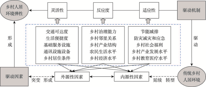
图6
乡村人居环境弹性形成机制因素剖析图
Fig. 6
Factors of the formation mechanism of rural human settlement resilience
(2)乡村人居环境系统的灵活性是弹性形成的基础性因素,灵活性主要表现为交通和居住等方面。交通方面表现为乡村交通运输体量、水运陆运的融通、智慧交通网络等方面的灵活性。居住方面主要集中在超市数量、电商普及率、体育场馆、移动网络覆盖等方面的灵活性,尤其是乡村居民的人均住房面积,结合乡村生活的特殊性,不仅仅只考虑乡村居民最基本的需求,如家禽的饲养、粮食的储存、摆放农具的杂物间等面积,在洞庭湖区还要考虑鱼塘的面积,渔船的数量等,灵活性指数的高低直接影响了乡村在短期内实现自给自足的能力,以及长期应对扰动的能力。
(3)乡村人居环境系统的反应度是影响乡村弹性形成的内在动力因素,反应度大小及快慢将直接影响灵活性和适应性的效应。反应度大或迅速可以在弹性形成的阈值范围内将影响扩大,引起足够的重视,以期在短期内更好的应对;但如果超过阈值,则会造成资源的浪费。而反应度太小或迟缓,则无法体现系统所受到扰动的实际情况,使得抗干扰能力无法及时发挥作用。反应度主要体现在经济、乡村社会关系等方面,经济是提高乡村增强自身发展动力和活力的核心支撑,农民是乡村人居环境弹性形成的主体,经济越发达,农民生活水平也会越高。受乡村社会关系、习俗文化、血缘宗亲关系、城乡“二元”户籍制度等影响,束缚着该区城乡融合发展,使得各乡村地区差异较大,这些都会影响乡村人居环境的反应度指数。
(4)乡村人居环境适应性是乡村人居环境由内及外的推动因素。在乡村人居环境弹性形成下,节能减排、防灾减灾和应急等可以增强系统应对扰动时的适应能力;乡村社会福利的不断提升可以激活乡村主体的活力;乡村农业发展水平可以提升经济的适应能力,既能够享受来自城市的辐射带动作用,也可以为城市提供所需的物质保障和劳动人口,变被动输入为主动输出;教育医疗水平可以提升乡村社会的适应能力,从根本上提高乡村人居环境主体的质量,为乡村人居环境高质量发展提供最直接的途径。
5 结论与讨论
5.1 结论
(1)洞庭湖区乡村人居环境弹性形成的区域差异明显。整体而言,乡村人居环境弹性均处于正在形成中,在空间上呈现出“内高外低”的格局。弹性形成指数与灵活性指数、适应性指数和反应度指数均呈正相关关系。其中,灵活性指数呈现出“内高外低”的态势,反应度指数呈现出“由内及外”的态势,适应性指数呈现出“外高内低”的态势。
(2)洞庭湖区乡村人居环境弹性形成可划分为3个环带。靠近洞庭湖区域内核的华容—临湘环带,中间环带澧县—平江环带和最外环带石门—赫山环带。不同环带应结合地区特色,合理规划和开发,推进乡村弹性的整体形成。① 弹性形成指数最高的华容—临湘环带,由于在3个环带中受江湖扰动最大,应统筹村庄安全和防灾减灾工程,充分利用各类大数据分析,对乡村活动和自然灾害进行动态监控和预测,并及时干预。② 弹性形成指数中等的石门—赫山环带,应提高基础服务设施建设水平,提升农民的创业能力,鼓励其就近乡镇就业,通过城乡融合,有序引导资本下乡,提升经济发展水平,为该区人居环境的发展提供物质保障。③ 弹性形成指数最低的澧县—平江环带,需不断提高农业机械化水平,促进该区农业土地整治、休闲观光农业等新型农业的发展,促进农业结构和产业的转型升级,激活区内的内生动力,平衡乡村环境保护和经济社会发展的关系,促进农业生产的可持续。
(3)洞庭湖区乡村人居环境弹性的形成受到外源因素和内源因素的影响。各影响因素之间存在交互作用,对弹性的形成产生正负作用,能增强或减弱乡村人居环境系统的弹性演变,导致各县市区乡村人居环境弹性形成的速度和程度各不相同。作为以第一产业为主导产业的典型农区,农业生产受自然环境的影响较大,居民观念受传统农区的影响较深,短期内要实现系统弹性的发展有较大难度,且存在显著的复杂特征。因此,把握弹性形成的合理阈值,有序调控各要素,统筹其互动流通,探索乡村人居环境系统的科学策略和路径,才能驱动该区朝弹性转型升级。
5.2 讨论
本文基于弹性乡村的视角,强调弹性对乡村人居环境系统作用过程及各要素之间的关联,尤其在指标体系构建中,关注乡村人居环境系统在受到外界冲击时的应急响应、抵御能力、防灾减灾等,通过技术手段,提高抗干扰的能力,不断与城市人居环境有机融合。洞庭湖区地理环境复杂、区域地位特殊,乡村面临的问题越来越多,乡村建设主体功能还不明确,迫切需要从其内部机制和未来发展路径上加以调控引导。因为受限于乡村人居环境数据获取的有限性,指标体系的构建主要以县域尺度为主,并偏向于社会、经济和自然类的指标,未来可选取更多典型的村庄,并从村域的角度来对弹性的形成机理进行深入剖析。
对洞庭湖区乡村人居环境弹性形成和优化发展提出如下建议:① 洞庭湖区主要为河湖冲积平原,丘陵、河流、湖泊交错分布,自然基底和生态系统本底条件较特殊和复杂,在进行人居环境系统内部优化的过程中,应对不同县域采用不同的对策和路径来发展,尤其是对于部分村域,应予以重点监督管控,从弹性的视角科学防范各类风险,合理控制系统内部的开发利用。② 该区农业生产资源丰富,平原地区可开展农业机械作业的规模化农业,不断提升农业生产效率,稳固农业生产的基础地位,保护农业生产基底,充分利用该区的劳动力资源,稳定人居环境内部系统。③ 经济和社会发展条件较好的县市区一般集中在离城市较近,或自身有特色产业的县域或村域,因此应对不确定性风险的能力也就越强,弹性形成的速度越快,但大部分外围乡村不具备弹性快速形成的条件,因此需结合外围乡村的实际,促进城乡一体化协调发展,带动乡村人居环境全面优化。④ 结合该区江湖扰动大的特点,应重视培育防灾减灾和应急管理部门的工作能力,注重给排水等基础设施的建设,重点解决相关难题,通过弹性的不断形成,将各类灾害的约束性限定在最低水平。总体来看,洞庭湖区的自然资源禀赋既是优势,也对人居环境发展的约束性较大,在未来的乡村人居环境优化发展中应注重全域资源的保护与生产生活的和谐,不断提升弹性,实现人地关系的可持续发展。
参考文献
Human geography research based on the new thinking of global rural-urban relationship
DOI:10.11821/dlxb202112001
[本文引用: 1]

Sustainable rural development is critical to the achievement of global sustainable development goals. Globalization and urbanization, as the key processes, continuously drive the human-earth system to make adaptive responses, promoting the transformation of urban-rural relations. The rural-urban relationship is essentially a mother-child relationship, which is a comprehensive characterization of the transfer of rural humanistic factors, the transformation of man-land relationship and the transformation of urban-rural development in the process of urbanization. However, the traditional cognition of urban-rural relationship ignores the multi-dimensional connections between the rural and the urban as well as the existence of the rural-urban integration system, resulting in prominent drawbacks of rural regions, negatively affecting the urban-rural development rights, and resulting in urban and rural territorial dysfunction and other problems. The key to solve the problems of socio-economic development in China is to reform the urban-biased development strategy, and to innovate the new cognition of rural-urban relationship based on the thinking of "rural maternal effect", which highlights that rural areas nourish the city. Based on the remote coupling and systematic synthesis of the rural human-earth system, modern human geography urgently needs to strengthen the cross-research with physical geography and information geography, create a coordinated observation system of human-earth system supported by the sky-space-ground integration, reshape the global rural development perspective, rural-urban system perspective, and reorganize the global rural human-earth relationship, the rural-urban integration relationship, and the living and employment relationship. Rural human-earth relationship territorial system is the core of rural geography research. The rural human-earth system research should focus on the coupling of rural natural ecosystem and the socio-economic system and their complex interactive processes and effects. Supported by the intersection of multiple disciplines, the expansion of new fields and the cultivation of new disciplines, it should create the collaborative observation technology of human-earth system and methodology of multi-source data fusion computing, the research idea based on process-mechanism-pattern and the technical path of monitoring-simulation-decision support, and explore the organic connection path between rural human-earth system coupling and rural-urban integrated development, regional sustainable development and global common governance.
全球乡城关系新认知与人文地理学研究
DOI:10.11821/dlxb202112001
[本文引用: 1]
全球化、城镇化作为驱动人地系统不断做出适应性调整和改变的关键过程,持续推动着城乡关系的转型与重塑。本文认为乡村孕育了城市,乡城关系实质上是母子关系,是城镇化进程中乡村人文要素转移、人地关系转变、城乡发展转型的一种综合表征,具体体现在不同发展阶段乡村与城市之间土地非农化、人口城镇化、产业园区化、城乡发展一体化等诸多方面;传统的城乡关系认知忽略了城市与乡村之间的内在关系和多维联系,以及城乡融合系统这一重要地理综合体及其功能价值,成为产生乡村短板效应凸显、城乡发展权能受损、城乡地域功能紊乱等突出问题的根源;转变城市偏向发展观念,基于乡村母体思维,创新全球乡城关系新认知是破解当前全球化特别是中国社会经济发展不平衡、不充分问题的关键所在。现代人文地理学迫切需要强化与自然地理学、信息地理学交叉研究,创建天—空—地一体化人地系统协同观测体系,突出乡村人地系统的远程耦合性和系统综合性,重塑全球乡村观、乡城系统观,探究可持续的全球乡村人地关系、城乡融合关系、村镇居业关系。乡村人地系统研究应聚焦乡村自然生态系统、社会经济系统耦合及其复杂交互过程与效应,以多学科交叉、新领域拓展与新学科培育为支撑,创建人地系统协同观测技术与多源数据融合计算方法论,基于过程—机理—格局的研究思路和监测—模拟—决策支持的技术路径,探寻实现乡村人地系统耦合与乡城融合发展、区域可持续发展及全球共同治理的有机衔接路径。
Introduction and Comment on The multiple reconstruction of integrated urban-rural: An empirical study of Northern Jiangsu Province
《面向城乡融合的乡村多维重构研究: 苏北地区的实证》评介
The state-of-the-art of agricultural geography and rural development research in China
中国现代农业与乡村地理学研究进展
Rural settlements research from the perspective of resilience theory
DOI:10.13249/j.cnki.sgs.2020.04.007
[本文引用: 1]
With the rapid progress of urbanization, rural development in China is facing increased vulnerability and instability. Under the policy guidance of rural revitalization and urban-rural integration, rural settlements are gradually showing a transformation trend of diversification and differentiation. It is an important task for rural geography to explore how different types of rural settlements deal with the disturbance of internal and external environment and reveal the multiple paths of rural settlements transformation. The notion of resilience is rapidly gaining ground as both a targeted process of societal development and as a research topic. Since the early 2000s, the concepts of resilience and vulnerability have begun to provide an important conceptual framework to understand how communities respond and adapt to environmental and societal changes. The resilience theory provides a new perspective for the study of rural settlement geography, and is of great significance for exploring and improving the ability of rural settlement systems to resist and resolve internal and external disturbances and sustainable development. Based on the resilience theory, this paper expounds the concept and theory of resilience, proposes to explore the multi-functional transformation of rural settlements from the perspective of resilience theory, to carry out systematic research on the resilience of rural settlements, and to analyze the measure of rural settlement resilience from the scale correlation and interaction mechanism of resilience. On this basis, this article proposed a resilience theory framework focused on the rural settlement. It will also try to seek an adaptive transformation path coupled with disturbance and impact for rural development, put forward the resilience strategy of the rural settlements development in China to provide theoretical guidance for the rural sustainable development, and rich rural geography theoretical research.
韧性理论视角下乡村聚落研究启示
DOI:10.13249/j.cnki.sgs.2020.04.007
[本文引用: 1]
伴随着城镇化的快速推进,乡村发展的脆弱性和不稳定性不断增强,在国家乡村振兴和城乡融合政策导向背景下,乡村聚落逐渐呈现出多元分化的转型态势。探索不同类型乡村聚落如何应对内外部环境的扰动,揭示其转型的多元路径是现代乡村地理学亟需关注的重要课题。韧性理论为乡村聚落地理学研究提供新视角,对于探究乡村地域系统如何抵御和化解内外部扰动,提升可持续性发展能力有着重要意义。在阐述韧性概念、理论基础上,提出从韧性理论视角探讨乡村聚落多功能转型,开展乡村聚落韧性的系统性研究,并从韧性的尺度关联以及相互作用机制分析乡村聚落韧性的测度,围绕韧性视角下乡村聚落的适应性转型及内在机制,为乡村发展寻求与扰动冲击相耦合的适应性转型路径,为乡村可持续发展提供理论指导和治理依据,丰富乡村地理学理论研究。
Rural regional system and rural revitalization strategy in China
DOI:10.11821/dlxb201912007
[本文引用: 1]
Rural regional system is a spatial system with certain structure, function and inter-regional relationship, which is composed of humanity, economy, resources and environment that are connected and interacted with each other. It is a regional multi-body system, including urban-rural integrity, rural synthesis, village-town organism, and housing-industry synergy. Targeting the rural regional system and supporting the rural revitalization strategy provides new opportunities and challenges for innovation of Chinese geography in the new era. Guided by the theory of regional system of human-land system and the science of human-land system, the research on rural revitalization geography should serve national strategy by finding solutions to problems hindering rural sustainable development, and make contribution to the comprehensive study of rural regional system structure, transformation process, evolution mechanism, differentiation pattern, regional function, and rural revitalization path and model under the interaction of surface's human-land system. There is an urgent requirement to better understand and reveal differences in the types of rural regional system and their differentiation law. Taking 39164 townships in China as research object, this paper used quantitative and qualitative methods to detect and identify the dominant factors that restrict the sustainable development of rural regional systems in China. Then we divided the types of Chinese rural regional systems, revealed the pattern of rural regional differentiation and further proposed scientific approaches to rural revitalization in different areas. Results demonstrate that topographic conditions, climate conditions, ruralization level, land resources endowment, population mobility and aging level are the dominant factors restricting the sustainable development of rural regional system, of which reflects the level of resource endowment, endogenous power and external aid of rural development. Through cluster analysis and spatial overlay of dominant factors, China's rural regional system can be divided into 12 first-class zones and 43 second-class zones. The first-class zones are named by means of 'geographical location + driving force of dominant factors', and the second-class zones are named by means of 'regional scope + driving force of dominant factors + economic development level'. The driving force of rural sustainable development in different regional types are varied. The regional pattern and path of rural revitalization in different types of areas are varied, and promoting the rural revitalization strategy should be based on local conditions to realize the coordination and sustainable development of rural economy, society, culture and ecosystem.
中国乡村地域系统与乡村振兴战略
DOI:10.11821/dlxb201912007
[本文引用: 1]
乡村地域系统是由人文、经济、资源与环境相互联系、相互作用下构成的、具有一定结构、功能和区际联系的乡村空间体系,是一个由城乡融合体、乡村综合体、村镇有机体、居业协同体等组成的地域多体系统。以乡村地域系统为对象,服务支撑国家乡村振兴战略,为新时期地理学创新研究提供了新机遇和新挑战。乡村振兴地理学研究,亟需以问题为导向、战略为指向,以人地关系地域系统理论和人地系统科学为指导,致力于地表人地系统交互作用下乡村地域系统结构、转型过程、演变机理、分异格局、地域功能,以及乡村振兴途径与模式综合研究,科学把握乡村地域系统类型及其分异规律。本文以全国39164个乡镇为基本单元,采用定量和定性相结合的研究方法,诊断识别了制约中国乡村地域系统可持续发展的主导因子,划分了中国乡村地域系统类型,揭示了乡村地域系统分异格局,探明了不同类型区乡村振兴科学途径。结果表明:① 地理环境、村镇化水平、资源禀赋、人口流动程度和老龄化水平等是乡村地域系统分异的主导因子,反映了乡村发展自然本底特征以及外援动力、内生动力的大小。② 通过主导要素聚类和空间叠加分析,将中国乡村地域系统划分为12个一级区、43个二级区。一级区采用“地理区位+主导要素驱动力/约束力”的方法命名,二级区采用“地域范围+主导要素驱动力/约束力+乡村经济发展水平”命名。③ 不同类型区乡村振兴地域模式和路径不同,乡村振兴战略与规划的落地要因地制宜、分类施策。
Resilience and stability of ecological systems
Resilient regions: Re-"place" ing regional competitiveness. Cambridge Journal of Regions
Rural resilience as a new development concept
Rural cosmopolitanism at the frontier? Chinese farmers and community relations in northern Queensland, c.1890-1920
DOI:10.1080/00049182.2017.1327785 URL [本文引用: 1]
Enhancing the analysis of rural community resilience: Evidence from community land ownership
DOI:10.1016/j.jrurstud.2013.02.003 URL [本文引用: 1]
Adaptive society in a changing environment: Insight into the social resilience of a rural region of Taiwan
DOI:10.1016/j.landusepol.2013.09.026 URL [本文引用: 1]
Socio-cultural roots of rural settlement dispersion in Sichuan Basin: The perspective of Chinese lineage
Rural Community and Rural Resilience: What is important to farmers in keeping their country towns alive?
DOI:10.1016/j.jrurstud.2011.09.003 URL [本文引用: 1]
The role of rural settlements in rural revitalization: Perspective of economic geography
DOI:10.18306/dlkxjz.2021.01.001
[本文引用: 1]
This article started with an analysis of the background of rural decline, and the content and logic of the national strategy of rural revitalization from the perspective of human-land relationship. We proposed that rural recession is the result of the adjustment of human-land relationship lagging behind the process of social and economic development. The ultimate purpose of rural revitalization is to adjust the relationship between human and land to adapt to the change of the value of production factors in the new stage of social and economic development. Then, the review of the literature on rural revitalization found that the existing research has paid more attention to the implementation of its strategic content, but not enough attention to rural settlements that have been the important carrier of rural population. There is a close relationship between rural settlement and rural revitalization. Rural settlements are the focus of human social and economic activities in rural areas, and are the core and starting point of rural human-land relationship adjustment. But in the existing literature on rural settlements, emphasis is placed on development cases and neglecting mechanisms, especially the mechanism of change of rural settlements, which is closely associated with rural revitalization. Therefore, bearing in mind the key role of rural settlements in rural revitalization, this article finally put forward five focus areas of future research: the theory of rural settlement evolution, changing trend of spatial structure in rural settlements, specialization transformation of rural settlements, optimization of rural settlements, and landscape of rural settlements.
乡村振兴下的聚落研究: 来自经济地理学视角
DOI:10.18306/dlkxjz.2021.01.001
[本文引用: 1]
论文首先从人地关系视角分析了乡村问题的背景及乡村振兴的内容逻辑,提出乡村衰退是人地关系调整滞后于社会经济发展进程的结果,乡村振兴最终目的就是调整人地关系以适应社会经济发展新阶段的生产要素价值变化。对乡村振兴地理研究的评述发现,多数关注其战略内容的实施,而对乡村人口重要载体的乡村聚落重视不够。事实上,乡村聚落与乡村振兴的关系密切,乡村聚落是乡村地区人类社会经济活动的集中场所,是乡村人地关系调整的核心和关键抓手,在乡村振兴中起关键作用。而已有的乡村聚落地理研究多聚焦空间变化,并且重实证轻机理,尤其是与乡村振兴相关联的聚落演变机理研究尚无成果问世。最后,基于乡村聚落在乡村振兴中关键作用,提出从人地关系协调出发,加强乡村聚落演变理论、乡村聚落空间结构变化趋势、乡村聚落专业化转型、乡村聚落整治优化及乡村聚落风貌景观等5个方面的研究。
Measurement and spatio-temporal evolution of rural resilience at county level in Hebei province
河北省县域乡村韧性测度及时空演变
The cognition and path analysis of rural revitalization theory based on rural resilience
DOI:10.11821/dlxb201910004
[本文引用: 1]
The rural decline which emerged in the process of human development and transformation has become a global trend, and rural revitalization is urgently needed. It is the only way to realize rural revitalization and sustainable development by scientifically and systematically grasping the development and evolution of rural regional systems, revealing the interaction mode of rural system and external development environment, as well as improving the rural resilience to resist and adapt to changes in the external environment. The article analyzes the development and evolution of rural regional systems and rural revitalization from the perspective of rural resilience. The study found that: (1) Rural resilience includes the resilience, adaptability and transformation ability of the rural system to the impact of external disturbances. (2) Rural development evolution differentiation is a comprehensive representation of the interaction between rural regional systems and the dominant factors of external development. In this process, the resilience of rural systems in different regions to resist external development disturbances has been improved or declined. (3) Creating multi-functional villages, implementing rural rectification projects, and cultivating rural social capital play an important role in promoting the construction of rural resilience. The article emphasizes that the rural regional system should be scientifically identified and differentiated implementation plans are formulated to cultivate and enhance rural resilience to achieve balanced function, structure and operation of rural system.
基于乡村弹性的乡村振兴理论认知与路径研究
DOI:10.11821/dlxb201910004
[本文引用: 1]
在人类社会发展转型过程中出现的乡村衰退问题已成为全球性趋势,亟需实施乡村振兴。科学、系统把握乡村地域系统的演化规律,深入揭示乡村系统与外界发展环境的交互作用模式,提升乡村自身抵御、适应外界环境变化的弹性,是实现乡村振兴与可持续发展的必由之路。本文从乡村弹性视角理论解析了乡村地域系统演化与乡村振兴。研究发现:① 乡村弹性包含乡村系统对外界扰动冲击的抵御能力、适应能力与实现全新发展的转型能力。② 乡村演化分异是乡村地域系统与外界发展主导因素交互作用的结果。在此过程中,乡村弹性决定着不同发展阶段乡村地域系统的演化方式和结果。③ 打造多功能乡村、实施乡村整治工程、培育乡村社会资本对构建弹性乡村起着重要的推动作用。文章强调应科学识别乡村地域系统,差异化制定培育与提升乡村弹性的实施方案,实现乡村系统功能、结构及运行达到均衡状态。
Multifunctional 'Quality' and rural community resilience
DOI:10.1111/tran.2010.35.issue-3 URL [本文引用: 1]
The impact of human settlement quality on rural development: A quantitative analysis based on the cross-sectional data of sampled villages in Jiangsu province
人居环境质量对乡村发展的影响: 基于江苏省村庄抽样调查截面数据的分析
Discussion on rural sustainability and rural sustainability science
DOI:10.11821/dlxb202004006
[本文引用: 1]
In the face of global environmental challenges, sustainable development has received much attention worldwide, and sustainability science has emerged in the 21st century as a globally well-recognized new area of science. Rural sustainability science, as an important part of sustainability science, is a use-inspired science aimed at understanding and improving the dynamic relationship between people and the rural environment from a transdisciplinary and multiscale perspective. In tandem with urban sustainability science, it provides much needed scientific support for dealing with rural decline and promoting rural sustainable development. In this paper, we first discuss the concepts of sustainability, rural sustainability, and rural sustainability science, and then propose a transdisciplinary integrated framework of rural sustainability science that focuses on agricultural sustainability, community sustainability, and rural human well-being. China is a nation with deep rural roots, complex problems involving interactions among agriculture, farmers, and villages, and huge urban-rural socioeconomic gaps. Since the reform and opening-up in 1978, China's rural areas have developed rapidly, but they still face numerous tough challenges. Rural revitalization strategies are needed for promoting the rural transition toward sustainability, but the necessary scientific basis and appropriate guidelines for formulating such strategies are still lacking. We argue that rural sustainability science can provide theoretical, technical, and decision-making support for the implementation of rural revitalization strategies. Our analysis of the current status of China's rural sustainable development indicates that the transition to sustainability is urgently needed, and so is the science that guides the transition. To address these problems, we call for transdisciplinary research that couples rural society and its environment, focusing on nine core issues in line with the needs of China's rural development and aiming to transfer knowledge of rural sustainability into local adaptive actions.
论乡村可持续性与乡村可持续性科学
DOI:10.11821/dlxb202004006
[本文引用: 1]
面对全球环境挑战,可持续发展备受关注,成为21世纪举世瞩目的新兴领域。乡村可持续性科学作为可持续性科学的重要组成部分,是一门以跨学科思维、多尺度视角来理解和改善乡村人地关系的、以应用为导向的整合型学科。与城市可持续性科学相互对应并相互联系,乡村可持续性科学是应对乡村衰退、促进乡村可持续发展所急需的科学支撑。本文在讨论可持续性、乡村可持续性与乡村可持续性科学概念基础上,以农业可持续性、社区可持续性与农民福祉为主要内容,构建了一个多学科综合的乡村可持续性科学研究框架。中国是一个农业大国,城乡差距明显,“三农”问题复杂,1978年改革开放以来,乡村发展迅速,但也面临艰巨挑战。乡村振兴战略的实施是推动中国乡村向可持续发展转型的有效途径,但其理论与实践体系尚不完善。具有中国特色的乡村可持续性科学的发展,可以为乡村振兴战略实施提供理论、技术与决策支撑。为此,本文对中国乡村可持续发展现状进行了分析,并基于文献分析探讨了中国乡村可持续研究的不足。结论显示,中国乡村迫切需要向可持续发展转型,但乡村可持续性科学基础薄弱,需借鉴国际经验,立足本国国情,强化跨学科研究与人地系统耦合研究,聚焦9个适应中国当前乡村发展需求的核心议题,并因地制宜地将乡村可持续性研究成果转化为指导乡村振兴发展的行动策略。
Spatial patterns, formation mechanism and coping strategies of rural vulnerability in China at the county level
DOI:10.11821/dlxb202106009
[本文引用: 1]
Based on the essential connotation of rural vulnerability, this study constructs an indicator system for the comprehensive measurement of rural vulnerability in China at the county level. Through the selection of five typical representative transects, we will deepen the analysis of the regional differences in China's rural vulnerability and its formation mechanism and propose targeted coping strategies. The results show that: (1) The rural vulnerability of counties in China is generally within the threshold range of low and medium vulnerability characterized by obvious spatial differences. Along the "Bole-Taipei Line", there is a spatial pattern of north-south differentiation. Villages in southwestern China tends to have higher vulnerability than those in northeastern China. (2) External environmental factors are the leading factors that induce rural vulnerability. The rural ecological subsystem, composed of ecological exposure, ecological sensitivity, and ecological adaptation, is the fundamental influencing factor of rural vulnerability. The rural economic subsystem, which is composed of economic exposure, economic sensitivity, and economic adaptation, is the core influencing factor of rural vulnerability. The social subsystem, composed of social exposure, social sensitivity, and social adaptation, is also an important factor influencing rural vulnerability. (3) On the basis of "geographical location, the dominant driving factors of rural vulnerability and the degree of rural vulnerability", rural vulnerability in China at the county level can be identified into eight categories. According to the principle of adapting measures to local conditions, we should break down the regional embeddedness and path dependence. We should strengthen the prediction and monitoring of the sources of disturbance in the rural-area system and scientifically control the sensitivity of the system itself, then improve the adaptation of the rural system to ensure sustainable development of rural areas.
中国县域乡村脆弱性空间特征与形成机制及对策
DOI:10.11821/dlxb202106009
[本文引用: 1]
基于乡村脆弱性本质内涵,构建了中国县域乡村脆弱性综合测度的指标体系,对中国县域乡村脆弱性水平进行综合测度;通过遴选具有典型代表性的5条样带,深化分析中国乡村脆弱性的区域差异特征及其形成机制,并提出具有针对性的应对策略。结果表明:① 中国县域乡村脆弱性整体上处于较低脆弱度和中脆弱度阈值区间,并具明显的空间差异性,沿“博台线”呈南北分异的空间格局,东北部乡村脆弱性偏低,西南部乡村脆弱较高。② 外部性环境因素是诱发乡村脆弱性的先导因素,生态暴露、生态敏感和生态适应构成的乡村生态子系统是乡村脆弱性的根本性影响因素;经济暴露、经济敏感和经济适应构成的乡村经济子系统是乡村脆弱性的核心影响因素;社会暴露、社会敏感和社会适应组成的乡村社会子系统也是乡村脆弱性的重要影响因素。③ 以“地理区位、乡村脆弱性主导驱动因素和脆弱性程度”为依据,将中国县域乡村脆弱性划分为8个地域类型区。不同类型区域,遵循因地制宜原则,破除地区根植性和路径依赖,增强乡村地域系统扰动源的预测和监测,并对系统自身敏感性进行科学管制,提升乡村系统的适应能力,促进乡村可持续发展。
Measurement and spatial-temporal differentiation of vulnerability of microscale rural human settlements in the semi-arid region of the Loess Plateau: A case study of Jiaxian County, Shaanxi Province
黄土高原半干旱区微尺度乡村人居环境系统脆弱性测度及时空分异: 以陕西省佳县为例
The resilience and vulnerability of remote mountain communities: The case of Vent, Austrian Alps
Natural streams and the legacy of water-powered mills
DOI:10.1126/science.1151716
PMID:18202284
[本文引用: 1]
Gravel-bedded streams are thought to have a characteristic meandering form bordered by a self-formed, fine-grained floodplain. This ideal guides a multibillion-dollar stream restoration industry. We have mapped and dated many of the deposits along mid-Atlantic streams that formed the basis for this widely accepted model. These data, as well as historical maps and records, show instead that before European settlement, the streams were small anabranching channels within extensive vegetated wetlands that accumulated little sediment but stored substantial organic carbon. Subsequently, 1 to 5 meters of slackwater sedimentation, behind tens of thousands of 17th- to 19th-century milldams, buried the presettlement wetlands with fine sediment. These findings show that most floodplains along mid-Atlantic streams are actually fill terraces, and historically incised channels are not natural archetypes for meandering streams.
Regional relationships between surface temperature, vegetation, and human settlement in a rapidly urbanizing ecosystem
DOI:10.1007/s10980-006-9032-z URL [本文引用: 1]
Factors influencing the rural settlement development
Spatio-temporal evaluation of rural human settlements quality and its differentiations in urban agglomeration in the middle reaches of the Yangtze River
长江中游城市群乡村人居环境质量评价及其时空分异
China's rural human settlements: Qualitative evaluation, quantitative analysis and policy implications
DOI:10.1016/j.ecolind.2018.01.006
[本文引用: 1]
Building a beautiful and livable countryside is essential to farmers' wellbeing, contributing to the development of New Socialist Countryside in China. Few of the existing studies have established a sound theoretical framework to evaluate rural human settlements from the perspective of farmers, who are the major beneficiaries of the rural human settlements. Therefore, this paper establishes a theoretical framework to evaluate both hard and soft rural human settlements qualitatively and quantitatively. Based on surveys from 6 provinces (cities) in central and eastern China, the theoretical framework is tested using Structural Equation Model (SEM). The empirical results show that the surveyed farmers are vaguely unsatisfied with their local rural human settlements, making improvement a must. Moreover, there is a significant correlation between rural sanitation, housing condition, rural infrastructure, farmers' economic burden, social services and rural human settlements, with rural sanitation and social services ranking at the top among the hard and soft human settlement indexes, respectively. Thus, the government should prioritize rural sanitation and social services to improve hard and soft human settlements, respectively. The discussions in this paper could provide solid foundations for policy makers to effectively improve rural human settlements.
Research on the suitability of population distribution at the county level in China
DOI:10.11821/dlxb201406001
[本文引用: 1]
The relationship between population distribution and resources, environment, social and economic development has attracted much attention for a long time. This paper set up an index system and some models for the assessment of the coordination between population and resources, environment, social and economic development. Then it used the index system and models to evaluate this coordination quantitatively at the county level. Based on this, the suitability and restriction of population distribution at the county level was graded and classified respectively, and its spatial and temporal patterns as well as regional characteristics were also revealed quantitatively. The results showed that: (1) population distribution was generally coordinated with human settlements environment in more than 3/5 of counties in China in 2010, which meant that population distribution was highly consistent with the natural suitability of human settlements environment at the county level; (2) population growth was merely not restricted by water and land resources in about half of counties in China in 2010, indicating that population distribution had medium coordination with the suitability of water and land resources; (3) population distribution was generally coordinated with social and economic development in more than 3/5 of counties in China in 2010, suggesting that population distribution was highly consistent with social and economic development; (4) the suitability degree of population distribution was larger than 60 in about 3/5 of counties in China in 2010, which showed that the relationship between population, resources, environment and development was coordinated or relatively coordinated; (5) as for the coordination between population, resources, environment and development at the county level, the eastern region was the best, the central region ranked second and the western region was the worst; (6) the suitability degree of population distribution at the county level could be identified into four grades, including basic coordination, relative coordination, under coordination and urgent need for coordination and 10 restricted classes.
基于分县尺度的中国人口分布适宜度研究
DOI:10.11821/dlxb201406001
[本文引用: 1]
以人口空间分布及其与资源环境和社会经济协调性评价为核心,提出了一整套人口与资源环境和经济社会发展协调水平评价的指标体系与模型方法;以分县为基本单元,定量评价了2010 年中国人口与资源环境和社会经济发展的协调性和协调程度;根据人口分布适宜度高低和限制性差别,划分了中国分县人口分布适宜等级和限制类型,定量揭示了中国不同地区人口与资源环境和社会经济协调发展的时空格局和地域特征。研究表明:① 2010 年中国有3/5 以上的县(市、区) 人口分布与人居环境基本适宜,中国分县人口分布与人居环境自然适宜性保持了高度一致性;② 2010 年中国有1/2 以上的县(市、区) 人口发展基本不受水土资源约束,分县人口分布与水土资源适宜性处于中等水平;③ 2010 年中国有超3/5 的县(市、区) 人口与社会经济发展基本协调,人口分布的社会经济协调性良好;④ 2010 年中国近3/5 的县(市、区) 人口分布适宜度在60 以上,人口资源环境与发展处于基本协调或相对协调状态;⑤2010 年中国分县人口资源环境与发展的协调程度东部优于中部、中部优于西部;⑥ 2010 年中国分县人口分布适宜度可划分为人口资源环境与发展基本协调、相对协调、有待协调和亟待协调4个适宜等级与10 个限制类型。
Factors influencing social capital in rural tourism communities in South Korea
DOI:10.1016/j.tourman.2012.02.005 URL [本文引用: 1]
Study on the AHP model of rurality inheritance in the ancient village of tourism development: A case study of Chuandixia village, Mentougou district, Beijing
DOI:10.13249/j.cnki.sgs.2012.011.1304
[本文引用: 1]
Rurality inheritance is a key issue of tourism development of ancient village. Construction model of assessment of rurality inheritance is researched in this paper, the main factors of the assessment model include village house,village culture, village economic, village society and village environment. The rural architectural inheritance appraises the ancient village building monomer (monuments and sites, historic buildings, traditional dwellings), architectural individuality and locality, the materials of the streets and lanes, context and texture, architectural style and historical and the integrity and authenticity of the cultural relics. The rural cultural inheritance appraises the rural lifestyle, villages oral history, religion, folk customs and rural festival or some other inheritance of the local rural culture. The agricultural economics inheritance refers to the inheritance of primary industry’s generalized agricultural economy, generalized production of agro-processing, traditional agricultural trade or some other aspects. The rural social heritage refers to the one of the rural social structure and power relations, including the internal relations of clan relations, neighborhood relations and the relations of rural governance or the other co-existence of the inter relations. The villages’ environmental inheritance refers to the protection of the overall settlement pattern of the ancient villages, surrounding landscape and rural ecological environment or the others. The choice of factors was based on the characters of old villages’ merits and distinctions. Subsequently, the model was used in recognizing the impact of rurality inheritance with rural tourism development,based on a case village, Cuandixia Village, the investigate of experts view about Cuandixian indicates that the development of rural tourism redounded to the keep of village houses, village culture, village society and village environment, but restrained the traditional village economic.
旅游开发中的古村落乡村性传承评价: 以北京市门头沟区爨底下村为例
DOI:10.13249/j.cnki.sgs.2012.011.1304
[本文引用: 1]
古村落乡村性传承是存续地方本土文化的关键问题之一,乡村性传承是古村落旅游开发的重要问题。考虑古村落旅游影响、乡村性特征随社会发展的必要性等趋势,构建古村落乡村性传承评价层次分析模型,评价因素包括乡村建筑、乡村文化、农业经济、乡村社会和乡村环境5个方面。案例分析以爨底下村为例,评价其在旅游开发背景下的乡村性传承情况,评价结果显示爨底下古村落的建筑、环境、乡村文化与乡村社会等方面的乡村性传承良好,但传统乡村经济特征传承较弱。
The organic renewal of the human settlement environment in traditional villages: Theoretical cognition and practical path
DOI:10.11821/dlyj020210368
[本文引用: 1]
Under the background of new urbanization, the human settlement environment in Chinese traditional villages is facing a rigorous crisis of the human-land relationship, and the organic renewal of it is particularly important. Based on the scientific connotation of the organic renewal and the evolution characteristics of the human settlement environment in Chinese traditional villages, this paper analyzed the theoretical cognition of the organic renewal of the human settlement environment in traditional villages, and constructed the path mechanism of the organic renewal of the human settlement environment in traditional villages on this basis. The results show that: (1) By summarizing the problems faced by the human settlement environment in traditional villages, the dilemma is classified as material space, cultural space and social space, and the theoretical cognition of the organic renewal is proposed with living-production-ecological space as the spatial carrier, the landscape gene as the cultural core, and the social field as the basic context. (2) Focusing on the renewal and optimization of material space, cultural space and social space, the three-dimensional path mechanism of "material-culture-society" for the organic renewal of the human settlement environment in traditional villages is constructed, including the renewal of the material space: the optimization of dominant functions and the reshaping of living-production-ecological space; the renewal of the cultural space: the repair of recessive genes and the repair of dominant genes; the renewal of the social space: the darning of relationship networks and the reconstruction of social order. In order to realize the sustainable development of the human settlement environment in traditional villages, the theoretical cognition and practical path of the organic renewal are discussed in depth, and have been established as a "multi-dimensional optimization, and multi-objective overall planning" mechanism, to provide scientific and practical reference for the organic renewal of the human settlement environment in Chinese traditional villages.
传统村落人居环境有机更新: 理论认知与实践路径
DOI:10.11821/dlyj020210368
[本文引用: 1]
新型城镇化背景下,中国传统村落人居环境面临着严重的人地关系危机,对其进行有机更新显得尤为重要。立足于有机更新的科学内涵及传统村落人居环境系统的演变特征,辨析了传统村落人居环境有机更新的理论认知,进而构建了传统村落人居环境有机更新的路径机制。研究结果表明:① 将传统村落人居环境系统的问题困境归类为物质空间、文化空间与社会空间,提出以三生空间为空间载体、景观基因为文化核心、社会场域为基础脉络的传统村落人居环境有机更新理论认知。② 以更新优化物质空间、文化空间与社会空间为着力点,构建了传统村落人居环境有机更新“物质-文化-社会”三维路径机制,包括物质空间更新:主导功能优化与三生空间重塑;文化空间更新:隐性基因修复与显性基因修补;社会空间更新:关系网络织补与社会秩序重构。以实现传统村落人居环境可持续发展为目标,通过建立“多维度优化-多目标统筹”的传统村落人居环境有机更新理论与路径,以期为中国传统村落人居环境有机更新提供科学参考与实践借鉴。
Recent progress on innovative urban infrastructures system towards sustainable resource management
DOI:10.1016/j.resconrec.2017.02.020 URL [本文引用: 1]
Resilience, vulnerability and adaptive capacity of an inland rural town prone to flooding: A climate change adaptation case study of Charleville, Queensland, Australia
DOI:10.1007/s11069-011-9791-y URL [本文引用: 1]
Towards the development of a GIS method for identifying rural food deserts: Geographic access in Vermont, USA
DOI:10.1016/j.apgeog.2009.05.004 URL [本文引用: 1]
Flood hazard zone mapping incorporating geographic information system (GIS) and multi-criteria analysis (MCA) techniques
Review on theoretical framework and evaluation system of rural resilience
乡村韧性理论框架与测度体系
Exploring wellbeing in human settlements: A spatial planning perspective
DOI:10.1016/j.habitatint.2019.04.007 URL [本文引用: 1]
Comparison of human settlement research in geography and architecture from the perspective of a theory tree
DOI:10.11821/dlxb202204003
[本文引用: 1]
The progress of human settlement research in geography and architecture is reviewed from the perspective of a theory tree. First, an exploration of the research skeleton indicates that the two disciplines have the same tree roots, that is, nine research subjects and eight research scales; the same tree trunks, that is, nine research subjects and eight research scales; and the same tree branches, that is, 33 research fields; however, they have different tree leaves, in other words, there are different quantities of research achievements in each research field. Second, a comparison of the characteristics of the research achievements indicates that the research achievements in the two disciplines differ significantly. For six secondary subjects (e.g., suitability), there are abundant research achievements in geography, but few in architecture. For six secondary subjects (e.g., planning) and the architectural scale, there are abundant research achievements in architecture, but few in geography. For twelve secondary subjects (e.g., spatial pattern) and six scales (e.g., city), in both disciplines, there are abundant research achievements, but the focus points of their research achievements differ. For the behavior of the secondary subject and global scale, in both disciplines, there are few research achievements, but the focus points of their research achievements differ. Finally, the generative logic of the difference in achievements between the two disciplines is analyzed, and future interdisciplinary research pathways are proposed. The logical starting point for different achievements is due to different discipline categories. The logical chain of the difference in achievements is the transmission mechanism of "discipline categories-discipline characteristics-researchers-research preferences-research paradigms-research achievements". Among them, the difference between research paradigms is an important link in the chain. In the future, human settlement research paradigms should be improved, including extending the research framework, developing research subjects, planning research scales, applying multisource data, and using mixed research methods. Moreover, there should be a response to the needs of real-world development in terms of globalization, beautiful human settlements, emergencies, and interdisciplinary cooperation.
学科树视角下地理学和建筑学人居环境研究比较
DOI:10.11821/dlxb202204003
[本文引用: 1]
本文从学科树视角比较分析地理学和建筑学的人居环境研究进展。首先,梳理研究脉络,指出两个学科具有相同的“树根”(即五大系统和五大层次)、“树干”(即九大主题和八大尺度)和“树枝”(即33个研究领域),以及相异的“树叶”(即各领域数量迥异的研究成果)。其次,比较研究成果特点,发现两个学科成果差异明显,表现为在适宜性等6个二级主题上,地理学成果较多,建筑学成果较少;在规划等6个二级主题和建筑尺度上,建筑学成果较多,地理学成果较少;在空间格局等12个二级主题和城市等6个尺度上,两个学科成果均较多,但侧重点不同;在行为二级主题和全球尺度上,两个学科成果均较少,但侧重点不同。最后,剖析学科成果差异的生成逻辑,并展望未来进路。学科成果差异的逻辑起点是学科门类差异,逻辑链条是“学科门类—学科特性—研究主体—研究偏好—研究范式—研究成果”的差异传导机制,其中研究范式差异是链条中的重要环节。未来人居环境研究应促进框架延伸化、主题展拓化、尺度统筹化、数据多源化、方法混合化等范式提升,同时回应全球化、美好人居、突发事件、跨学科等现实需求。
Rural planning innovation under the background of urban-rural integration development
DOI:10.2307/142598 URL [本文引用: 1]
城乡融合发展背景下的村庄规划创新研究
Comprehensive evaluation of trends in human settlements quality changes and spatial differentiation characteristics of 35 Chinese major cities
DOI:10.1016/j.habitatint.2017.10.001 URL [本文引用: 1]
Sustainable development ability and its spatiotemporal differentiations of rural human settlements in Chongqing Municipality from 1997 to 2015
DOI:10.18306/dlkxjz.2019.04.008
[本文引用: 1]
As a complex system, the sustainable development ability of rural human settlements is the result of the exchange of materials, information, and energy among its subsystems. This study established an evaluation index system of sustainable development ability of rural human settlements based on the three subsystems of economic development, living-production, and ecological environment, and used panel data from 37 districts and counties in Chongqing Municipality from 1997 to 2015 as the data sources. By using development level that measures the sustainable development situation of rural human settlements, development efficiency that reflects the pace of sustainable development, and coordination index that reflects the coordination degree among subsystems, this study analyzed the sustainable development ability of the rural human settlements and examined its spatiotemporal differentiation characteristics, in order to provide some strategies for the practice of the three-year action plan of rural human settlements improvement in Chongqing Municipality. The results show that, from 1997 to 2015, the overall sustainable development ability of rural human settlements of Chongqing was reasonably high. Among the three subsystems, development level gradually improved, development efficiency fluctuated significantly, coordination degree enhanced stably, and the development level showed great differences among the subsystems. The sustainable development ability of rural human settlements presents a spatial pattern of "low in the east, high in the west" and center-periphery differentiation, as well as wide variations among the districts and counties as a whole. The development level of the economic development subsystem showed a spatial pattern of multilevel core-surrounding zonal differentiated growth. The development level of the living-production subsystem showed a spatial pattern of diffusion growth from the west to the east. The development level of the ecological environment subsystem declined first and then increased and showed a spatially unevenly growth. On these bases, this study put forward some strategies for improvement from the aspects of planning and guidance by the government, urban and rural coordination, and the “point-pole-core” development model.
重庆直辖以来乡村人居环境可持续发展力及其时空分异研究
DOI:10.18306/dlkxjz.2019.04.008
[本文引用: 1]
乡村人居环境是一复杂巨系统,其可持续发展力是各子系统间物质、信息与能量相互流通与交换的结果,本文从经济发展、生产生活、生态环境3个子系统入手构建乡村人居环境可持续发展力的评价指标体系,以1997—2015年重庆市37个区县的面板数据为数据源,运用发展水平(衡量乡村人居环境可持续发展态势)、发展效率(反映乡村人居环境发展趋向可持续的快慢程度)和协调指数(反映各子系统发展水平均衡程度)构建乡村人居环境可持续发展力测度模型,分析了乡村人居环境可持续力并探究其时空分异特征,为因地制宜践行《农村人居环境整治三年行动方案》提供策略支持。结果表明:1997—2015年,乡村人居环境可持续发展力时序上总体态势向好,其中发展水平逐步上升,发展效率波动剧烈,协调性稳步提高,各子系统间可持续发展力差异性较大;乡村人居环境可持续发展力在空间上总体呈现西高东低、“中心-边缘”的分异格局,区县间差异性明显,其中经济发展子系统呈“多级核心-外围”辐射圈层式差异化增长格局、生产生活子系统呈自西向东扩散式增长格局,生态环境子系统总体上先降后升,呈波浪式不均衡增长格局;从政府“制导引导”、城乡“双轮”联动、“点-极-核”整治模式等方面提出了相关整治策略。
Research progress on human settlement evolution
DOI:10.11820/dlkxjz.2013.05.003
[本文引用: 1]
Human settlement is a general term used for a temporary or permanent living space of human beings. It is also the place where human activities have most severe effects on the natural environment, hence the focus of academic studies. In this article we reviewed the development of human settlement research and summarized theories and methods on human settlement evolution at home and abroad. We discussed the research progress on data platform monitoring the dynamic changes, indicator system evaluating evolutional trends, key influence factors and mechanisms, and integrated simulation models. Generally speaking, the concept, content, influence factors, and evolutional mechanisms have not been clearly understood yet. Overseas researches are using modern geographic approaches and modeling methods to generate insights into the dynamic changes of human settlements. They also introduced integrated researches from geography, urban planning, sociology and ecology into the mechanism studies. However, the focus of Chinese researches is mainly the evaluation of human settlement; there is little research on the evolutional mechanism of human settlement. We suggested that more inter-discipline collaborations, integrated databases, modern analytical approaches, and modeling methods are needed in this research realm. We pointed out that the regions undergoing rapid urbanization in China are experiencing drastic environmental and social changes and are worth studying.
人居环境演变研究进展
DOI:10.11820/dlkxjz.2013.05.003
[本文引用: 1]
人居环境作为人类栖息地,随着人类活动影响范围和强度的增加,人居环境问题越来越突出,人居环境演变过程也成为学术界关注的热点.本文梳理了近20 年来关于人居环境演变的相关研究理论与方法,从人居环境演变趋势的影响因素分析、演变机制探析和研究方法等方面评述了国内外的研究动向.总体而言,人居环境研究呈现出多学科交叉、集成研究的特点,在数据获取、演变过程的研究上更多地采用了现代化技术和模拟分析方法,但学术界对人居环境的内涵、演变机制解析等仍然存在着分歧.与国外研究相比,中国人居环境研究起步较晚,研究内容限于人居环境评价,对人居环境演变机理涉及较少,且研究数据和方法较为单一.最后本文对未来研究进行了展望.
A comparative study of Chinese translation of resilience terminology in socio-ecological system and its related research fields
DOI:10.22217/upi URL [本文引用: 1]
恢复力、弹性或韧性? 社会—生态系统及其相关研究领域中“Resilience”一词翻译之辨析
Research on the evolution law and promotion pathway of rural human settlements system resilience: A case study of western Chongqing, a national pilot area for urban-rural integration
DOI:10.31497/zrzyxb.20220307
[本文引用: 1]
This study takes Western Chongqing, a national urban-rural integration development pilot area, as the research area, and 2009-2019 as the research period. Based on the systematic analysis, according to the research ideas of ideological origin, theoretical foundation, empirical research and promotion path, this study constructs an index system to measure the rural human settlements system resilience, analyzes its evolution law, and then uses the obstacle degree model to identify the obstacle factors of rural human settlements system resilience. In order to break the multiple constraints of the resilience of rural human settlements in the western part of Chongqing, the paper designs a path to enhance the resilience. Results show that: From 2009 to 2019, the resilience level of rural human settlements in Western Chongqing shows a rising trend, which is characterized by the spatio-temporal differentiation of decreasing from south to north. The resilience of each subsystem shows different degrees of growth in time and significant differences in space. According to the results of obstacle factor analysis and leading obstacle diagnosis in the study area, the resilience improvement can be divided into three types: single dominant barrier type, double barrier type and triple barrier type. Based on this, the differentiation path of rural human settlements system resilience improvement is designed to promote the construction of livable countryside and boost the overall rural revitalization. It has important demonstration effect.
乡村人居环境系统韧性的演变规律及其提升路径: 以国家城乡融合发展试验区重庆西部片区为例
DOI:10.31497/zrzyxb.20220307
[本文引用: 1]
以国家城乡融合发展试验区——重庆西部片区为研究区,以2009年、2014年、2019年为研究时点,以2009—2019年为研究时段,按照思想缘起、理论基础、实证演绎、提升路径的研究思路,建立乡村人居环境系统韧性测度的指标体系,分析其演变规律。研究结果表明:2009—2019年,重庆西部片区的乡村人居环境系统韧性水平不断上升,呈现出“南高北低”的空间格局。各子系统韧性在时间上呈现出不同程度的增长趋势,在空间上差异明显:自然系统韧性与人类系统韧性分别呈现出“由南向北递减”和“东西部向中部递减”的空间格局;居住系统韧性与支撑系统韧性则分别呈现出由“低值点缀分布”逐渐过渡到较为均衡和“普遍均衡、高低值点缀”的空间格局;社会系统韧性表现为“西部增强、东部减弱”的空间格局特征。借助障碍度模型对重庆西部片区乡村人居环境系统韧性提升的障碍因子及不同区县面临的主导障碍进行诊断,根据结果将重庆西部片区划分为单一主导障碍型、双重障碍型与三层障碍型三种类型,据此设计乡村人居环境系统韧性提升的差异化路径,以期打破重庆西部片区乡村人居环境系统韧性提升的多重制约。
Human settlements in China based on the geographical scale
DOI:10.13249/j.cnki.sgs.2022.06.001
[本文引用: 1]
Over the past decades, China has made great progress in industrial development, urban construction and information technology, and it leads to tremendous changes in the human settlements. In addition, socio-economic development has introduced the diversified human activities, which brings new challenges to the cognition of traditional human settlements. In this paper, a new division of domestic human settlements have been proposed, it is divided into real human settlements, imagery human settlements and pseudo human settlements (i.e. the “three states” of human settlements) based on the geographical scale. Using the “subjective literature induction + objective literature bibliometrics” approach, this paper reviews and prospects the related studies on human settlements from the geographic scales of “three states”, including its content, data and methods. From the analysis above, the following conclusions are drawn in this paper. ① The studies of human settlements have the tendency to be comprehensive and integrated in terms of themes, disciplines and directions. The studies of human settlements have made great progress in understanding the human-land relationship. An increasing number of studies consider the impact of different geographical scales on human settlements. ② Dataset of human settlements shows a trend towards quality optimization, with increasing resolution and precision. The trend of spatio-temporal integration of data from multiple sources is becoming more and more evident. The combination of “big data” and “small data” is also the characteristic of human settlements. ③ Qualitative studies have made significant advances in investigation forms, analytical tools and methods. Growing numbers of econometric models are being developed for the study of human settlements. At the same time, the aggregation of “big data intelligent analysis + small data sampling survey” is applied to explore the relation between human and environment. In the future, domestic studies of human settlements should deepen the logic analysis principle of “one horizontal + one vertical”. On the one hand, scholars should focus on the spatio-temporal characteristics of different human activities (such as living, working, transportation and recreation) at the horizontal scale. On the other hand, much attention should be paid to the deep structure of human settlements under the trend of “reality- imagery -pseudo” at the vertical scale. Domestic studies should be centered on the “three states” of human settlement and diversified human activities. Finally, the Science of Human Settlements would be gradually evolutionary into the multi-perspective, multi-fields, and systematically integrated discipline group.
基于地理尺度的中国人居环境研究进展
DOI:10.13249/j.cnki.sgs.2022.06.001
[本文引用: 1]
对国内人居环境的地理尺度进行了新的划分,主体分为现实人居环境、意象人居环境和拟态人居环境(即“三态”),采用“主观文献归纳+客观文献计量”的方法对地理尺度视角下的人居环境内容、数据和方法等进行评述与展望。① 研究内容趋向综合集成化、新人地关系“广深化”和尺度交叉化等;② 研究数据表现出质度和量度的优化态势、多源数据的时空融合趋势和“小数据+大数据”的组合互补方向等;③ 研究方法体现在质性研究的更新化、计量模型的丰富化和“大数据智能分析+小数据抽样调查”的聚合化等。未来,国内人居环境研究应深化“一横+一纵”的逻辑分析原则,横向尺度关注居住、工作、交通、游憩等不同人类活动的时空特征,纵向尺度关注现实人居环境、意象人居环境及拟态人居环境融合趋势下人类聚居的深层结构,围绕着“三态”人居行为逐步完善为多视角、多领域和系统综合的学科群组。
