

1 引言
丹霞景观指以丹霞地貌为主体的景观风貌,其包含丹霞自然景观和丹霞人文景观两个层面。本文主要研究丹霞景观的自然景观范畴,包括以丹霞地貌为核心的颜色、崖壁高度、坡面形态、单体景观、群体景观等主体景观要素和植被、水体等辅助景观要素,以及岩性、地层时代、演化阶段、岩石强度、地层产状、其他岩石夹层等形成地域性丹霞景观差异的影响因素。
红层是丹霞景观发育的物质基础,目前对红层分布的认识已比较深入。中国红层出露面积为9.16×10⁵ km2,占国土面积的9.5%[20],红层区承载人口多达1.44亿[21]。白垩系出露红层占出露总面积的57%,绝大部分沿主要断层线分布;侏罗系红层占25%,主要分布于四川盆地;三叠系红层主要分布于云南元谋县,占4%;古近系和新近系红层主要分布在塔里木盆地和准噶尔盆地边缘,分别占红层总面积的5.1%和4.8%[20]。依据出露红层的空间分布,可划定丹霞地貌在空间上的大致范围,但由于丹霞景观是岩性、构造、气候、时间等多种因素共同作用的结果,因此深入了解其分异规律需要综合对比分析红层分布、构造、气候等诸多因素的影响与关联。
相较于岩石地貌学的其他学科,丹霞地貌学科理论体系的构建依然不够完善。目前存在的争议主要集中于丹霞地貌的定义和控制因素等学科基础理论问题[29-30]。例如,由于丹霞地貌的多样性,导致学者在下定义时,是否应对颜色、地貌形态、地貌过程、形成时代和地质构造等进行限定[31⇓-33],说法不一。在丹霞地貌的控制因素中,目前对岩石力学性质的影响机制研究较为深入:垂向上岩层抗侵蚀能力的差异,导致丹霞崖壁差异风化并形成顺层凹槽[34⇓-36]。闫罗彬等基于3D有限元的模拟发现,顺层凹槽的扩展使得岩体力学状态发生变化,这是导致丹霞崖壁崩塌(新崖壁形成)的直接原因[37]。但是,岩性仅是丹霞地貌多个控制因素之一,单一的案例研究难以获取其他因素的影响。因此,大尺度丹霞地貌景观特征的调查和区域对比,有助于进一步深化对丹霞地貌控制因素这一基础理论问题的认识。
本文主要以科技基础资源调查专项“全国丹霞地貌基础数据调查”获取的176处丹霞地貌本底信息为数据源,用可定量的丹霞景观要素和景观影响因素(地层时代、岩性、岩层产状、崖壁高度和岩石强度)初步确定丹霞景观空间格局,再结合考察过程中对难以定量的景观要素的区域差异形成的认识,确定丹霞景观的空间分异,最后通过区域对比尝试理解地质、气候、时间和生物等各个控制因素在其空间分异中的作用。
2 数据来源和研究方法
中国丹霞地貌成景地层时代数据来自《中国丹霞地貌简表》[6]。岩层产状、崖壁高度和岩石单轴抗压强度等数据来自国家科技基础条件平台——国家地球系统科学数据中心(
3 丹霞景观特征空间分异
3.1 成景地层时代的空间分布
丹霞地貌成景地层的时代数据涵盖黄进统计的1104处和本次调查新增的15处丹霞地貌,共1119个。地层时代分布如图1所示。成景地层全部为白垩系红层的丹霞地貌有666处,另有85处丹霞地貌地层中部分包括白垩系地层。这85处丹霞地貌中,有42处丹霞地貌的下部为侏罗系、上部为白垩系地层,多位于四川盆地;下部为白垩系地层而上部为古近系地层的丹霞地貌34处,多位于贵州。古近系红层形成的丹霞地貌133处,另有部分成景地层为古近系的丹霞地貌45处。总体上白垩系丹霞最多,其次是古近系、侏罗系和新近系。如图1所示,四川盆地中部和东部以侏罗系为主,南部以白垩系或白垩—侏罗系为主;三叠系红层形成的丹霞大多位于山西省境内。华南地区丹霞地貌成景地层以白垩系为主,其次为古近系;新近系丹霞多分布于鄂尔多斯盆地的西南缘和塔里木盆地外围。已发现地层时代最古老的丹霞地貌位于甘肃省古浪峡,地层为泥盆系上统沙流水群(D3sh)[43]。
图1
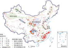
图1
构成丹霞地貌的地层时代分布特征
注:基于自然资源部标准地图服务网站审图号为GS(2019)1823号的标准地图制作,底图边界无修改。
Fig. 1
Geological age of Danxia landscape strata
3.2 成景地层岩性空间分布
根据丹霞地貌成景地层主体的岩性,可将其分为3大类:以砂岩为主、以砾岩为主和以砂砾岩为主。成景地层岩性空间分布如图2所示。以砂岩为主的丹霞地貌有315处,占全国丹霞地貌总数量的28.5%;以砾岩为主的丹霞地貌有73处,占比为6.6%,其余均为砂砾岩丹霞。不同岩性丹霞地貌的分布规律表现为:砂岩丹霞集中分布在四川盆地、黄土覆盖的陕西和山西省以及天山两侧,其他地区有零星分布;砾岩为主的丹霞主要分布在东南沿海和四川盆地西缘。
图2
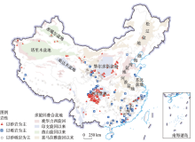
图2
中国丹霞地貌的岩性特征的空间分布
注:基于自然资源部标准地图服务网站审图号为GS(2019)1823号的标准地图制作,底图边界无修改。
Fig. 2
Spatial distribution of lithology in Danxia sites in China
3.3 成景岩层产状空间分布
依据岩层产状可将丹霞地貌分为3类,近水平(<10°)、缓倾斜(10°~30°)和陡倾斜(>30°)[9]。大多数面积较小的丹霞地貌区岩层产状表现出一致性,但在一些大型红层盆地内部(如丹霞盆地),地层所处盆地位置或局部断裂影响,可能导致同一盆地内岩层产状不同。针对面积较大的丹霞地貌区,本文所指岩层产状为多数崖壁的成景岩层产状。根据野外测量,共获取235处成景岩层产状数据,其空间分布如图3。近水平丹霞有134处,占比为57.0%;缓倾斜丹霞53处,占比32.5%。整体表现为,西北部陡倾斜丹霞地貌较多,而东部近水平和缓倾斜丹霞较多,新疆天山两侧丹霞大多为陡倾斜。总体上,绝大多数丹霞地貌为近水平和缓倾斜丹霞,基本遵循“顶平、身陡、麓缓”的坡面形式。依据贾承造对新构造运动的分区[39],全国丹霞地貌岩层产状总体上表现为:在环西太平洋裂谷区和环青藏高原盆山体系的东部克拉通(四川盆地和鄂尔多斯盆地)近水平或缓倾斜丹霞较多(图3);在青藏高原盆山体系的北部,地层以陡倾斜为主。
图3

图3
中国丹霞地貌成景岩层产状的空间分布
注:基于自然资源部标准地图服务网站审图号为 GS(2019)1823号的标准地图制作,底图边界无修改;不同构造构造域底图据贾承造等[39]绘制。
Fig. 3
Spatial distribution of attitude of Danxia site strata
3.4 丹霞地貌的崖壁高度空间分布
在全国范围内,获取133处丹霞地貌崖壁高度数据。数据集包括最大崖壁高度和一般崖壁高度。由于一般崖壁高度为调查者根据观察到的崖壁高度进行估计得出,误差较大,因此本文所使用崖壁高度为最大崖壁高度,指丹霞地貌顶部到附近水域的海拔差值。由于鄂尔多斯高原多为沟谷型丹霞地貌,故样本中不包括该区域的数据。崖壁高度的空间分布如图4所示。崖壁高度最大值为600 m,平均值为250 m。总体上,东南部(广东、浙江、福建和江西)丹霞崖壁较高,平均值为330 m;西北部(甘肃和宁夏)丹霞地貌平均高度为162 m;川渝黔边区丹霞地貌崖壁明显较高;祁连山北麓丹霞地貌的崖壁高度一般在50 m以下。
图4
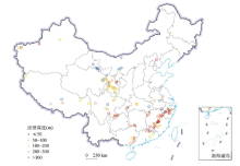
图4
中国丹霞地貌崖壁高度的空间分布
注:基于自然资源部标准地图服务网站审图号为GS(2019)1823号的标准地图制作,底图边界无修改。
Fig. 4
Spatial distribution of the cliff height in Danxia sites
3.5 丹霞地貌成景地层岩石强度
图5
图5
砂岩和砾岩单轴抗压强度的空间分布
注:基于自然资源部标准地图服务网站审图号为GS(2019)1823号的标准地图制作,底图边界无修改。
Fig. 5
Spatial distribution of uniaxial compressive strength of sandstone and conglomerate
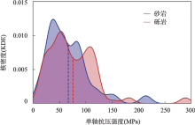
运用KDE法计算两类岩石的核密度分布(图6),砂岩平均强度小于砾岩,但两类岩石单轴抗压强度的密度分布出现较大重叠,说明丹霞成景地层岩石类型并不能决定单轴抗压强度。砾岩单轴抗压强度的核密度表现为“双峰型”分布。此外,强度小于20 MPa的岩样中砾岩和砂岩比例相当,而强度大于110 MPa的岩样中,砾岩岩样的数量占主导。
图6
4 不同区域丹霞景观特点
在上文中对地层时代、岩性、岩层产状、崖壁高度和岩石强度等空间分布特征分析的基础上,同时结合对全国22个省级行政区超过200处丹霞地貌的实地考察过程中获得的对地表环境、坡面形态、当前活跃的地貌过程和景观特色的认识,将全国丹霞景观划分为6个片区(图7),对各区域当前主要地貌过程和丹霞景观特征总结如下:
图7
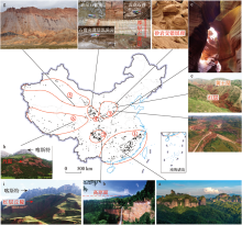
图7
不同区域代表性丹霞景观
注:基于自然资源部标准地图服务网站审图号为GS(2019)1823号的标准地图制作,底图边界无修改;① 东南部丹霞景观区,② 川渝黔边区丹霞景观区,③ 鄂尔多斯高原丹霞景观区,④ 鄂尔多斯盆地西南缘丹霞景观区,⑤ “天山—祁连”沿线丹霞景观,⑥ 青藏高原丹霞景观区;a 广东丹霞山东部群峰景观,b 贵州赤水高原峡谷型丹霞景观,顶部存在明显的高原面,c 陕西省延安市甘泉县雨岔峡谷,d 陕西榆林市靖边县龙洲波浪谷—沙漠相砂岩地层,存在明显的大型板状、槽状交错层理,e 陕西榆林市靖边县天赐湾小型嵌入式曲流丹霞景观,上部为黄土,下部为红层,f 陕西省延安市志丹县洛河丹霞—丹霞地貌形成于深切河曲的两岸,g 青海省大柴旦五彩谷丹霞,h和i为青藏高原丹霞地貌与红层丘陵,顶部多发育喀斯特石林,j 西宁北山—崖壁由砂泥岩红层与不同厚度的石膏层构成;a为刘加青拍摄,b为王茂祥拍摄,c~f为彭华拍摄,g~j为闫罗彬拍摄。
Fig. 7
Typical Danxia landscapes in different regions of China
4.1 东南部丹霞景观区
4.2 川渝黔边区丹霞景观区
该区域的丹霞地貌多为近水平砂岩丹霞,地貌演化阶段多为青年期,以深切峡谷和瀑布众多为景观特色。单体和群体地貌类型不丰富。活跃的地貌过程为流水下蚀和崩塌,峡谷内多崩塌巨石,顶部高原面保存完整(图7b)。丹霞崖壁沿着马蹄形瀑布后退方向延伸,瀑布后壁多为“圈椅”状,河流多阶跃型“裂点”。
4.3 鄂尔多斯高原丹霞景观区
4.4 鄂尔多斯盆地西南部丹霞景观区
该区域包括青海湖以东和甘南以西,位于不同气候区和构造板块的边界,形成的丹霞景观多样。该区域近水平丹霞和陡倾斜丹霞占区域总数的43%和33%。发育于白垩系地层的丹霞地貌崖壁高度较大,如积石峡丹霞、崆峒山、炳灵寺等。青海湖以东黄河—黑河流域丹霞地貌多数发育于古近系和新近系地层,胶结程度弱,丹霞崖壁多低矮、顶部浑圆。丹霞顶部大多具有黄土盖层。同时,存在以红色泥质岩和石膏互层发育的丹霞地貌,整体呈红色,其中石膏层呈灰绿色,结晶类型多样,占崖壁比例较大,如青海互助县白马寺、西宁南山和北山等(图7j)。这类丹霞景观在湿润区难以长期存在。
4.5 “天山—祁连”沿线丹霞景观区
该区域丹霞景观主要沿着天山两侧的背斜两翼和祁连山北侧分布,陡倾斜丹霞数目占该区域丹霞地貌数量的67%。丹霞崖壁多为背斜形成的峡谷两壁。当前活跃的地貌过程为风化。不同颜色单斜地层呈带状展布,色彩丰富,如青海大柴旦五彩谷等(图7g)。部分地区丹霞崖壁仅出现在侵蚀河谷一侧,如吐鲁番火焰山。由于降水量少,弱胶结的粉砂岩、泥岩因顶部存在坚硬的砂岩或者砾岩盖层,可形成高度不大的陡崖或石柱,这类现象在干旱区常见。
4.6 青藏高原地区丹霞景观区
4.7 各区域丹霞景观对比
本文将各个区域丹霞景观的特点总结如表1。
表1 各区域丹霞景观的对比
Tab. 1
| 区域 | 盆地类型 | 岩性 | 岩性与产状 | 坡面形态 | 成因 | 活跃地貌过程 | 气候 | 景观特色 | 地貌演化 阶段 |
|---|---|---|---|---|---|---|---|---|---|
| 东南部 | 断陷盆地 | 砂砾岩 | 缓倾斜+近水平 | 竖向+水平凹槽 | 抬升→流水下切→崩塌 | 崩塌 | 湿润 | 峰林峰丛、森林+碧水 | 青年晚期、壮年期、 老年期 |
| 川渝黔边区 | 大型坳陷盆地 | 砂岩 | 近水平 | 水平凹槽 | 抬升→流水下切→崩塌 | 流水下蚀+崩塌 | 湿润 | 深切峡谷+瀑布众多+森林 | 青年早期 为主 |
| 鄂尔多斯 高原 | 大型坳陷盆地 | 砂岩 | 近水平 | - | 抬升→流水下切 | 流水 下蚀 | 半干旱 | 黄土覆盖+崖壁层理丰富 | 幼年期为主 |
| 鄂尔多斯 盆地西南部 | 断陷 盆地 | 砂砾岩 | 缓倾斜 | 水平凹槽 | 抬升→风化、崩塌 | 温差+盐风化 | 多样 | 顶部黄土+厚层石膏 | - |
| “天山—祁连”沿线 | 大型坳陷盆地 | 砂岩或砂砾岩 | 陡倾斜 | 不平整 | 褶皱抬升(背斜) | 温差+盐风化 | 干旱 | 带状展布+色彩丰富 | - |
| 青藏高原 地区 | 断陷 盆地 | 砂砾岩 | 陡倾斜或缓倾斜 | 水平凹槽 | 古丹霞→寒冻风化改造 | 寒冻 风化 | 高寒 | 喀斯特与 丹霞共存 | - |
5 喜马拉雅运动对丹霞景观分布的控制
图8
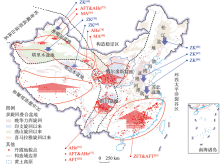
图8
不同构造域红层分布区的构造升降格局
注:基于自然资源部标准地图服务网站审图号为GS(2019)1823号的标准地图制作,底图边界无修改;钻孔数据来自蓝色参考文献,表明盆地下部埋藏厚层陆相红层[64,66⇓⇓⇓ -70],低温热年代学数据和磁性地层学数据来自红色参考文献[53,56⇓ -58,60,71⇓⇓ -74],表明在喜马拉雅运动期间发生大幅抬升,不同构造构造域底图据贾承造等[39];ZK为钻孔数据、MA为磁性地层学方法、AFT为磷灰石裂变径迹法、AHe为磷灰石(U-Th)/He技术、ZFT为锆石裂变径迹法。
Fig. 8
Crustal compression and extension during the Himalayan movement in the redbed region
中国喜马拉雅构造期陆内变形构造性质与特征由青藏高原挤压隆升和太平洋板块俯冲拉张共同控制。贾承造将喜马拉雅构造运动的发育特征归为青藏高原隆升、盆地与造山带体制和东部拉张活动,并将其构造特征分为3种类型,分别为东部拉张环境控制的裂谷沉降、中部地块抬升剥蚀和西部盆地压缩挠曲沉降与冲断隆升[39]。
中国东南部和中部稳定抬升区(鄂尔多斯和四川盆地)丹霞地貌密集,在东北和华北丹霞地貌数量少,西北地区主要分布在三大盆地边缘和祁连山北侧,青藏高原丹霞多出现在块体边缘(图8)。
鄂尔多斯高原西南缘位于环青藏高原盆山体系的北部。从印支期到喜马拉雅运动期,各时期构造活动强烈,形成大量山间盆地,沉积从中侏罗系到新近系不同时期红层。磁性地层学研究表明,该区域在10 Ma以来经历多期构造隆升,是对青藏高原隆升过程的响应[60]。
分析发现,东北部和西北大部分红层盆地因位于喜马拉雅运动沉降区而被第四系沉积物掩埋,不具备形成丹霞地貌的条件。丹霞地貌密集的区域均位于喜马拉雅运动的抬升区,是对青藏高原隆升的响应。因此,燕山运动以来的红层沉积范围和喜马拉雅运动共同控制了中国丹霞景观的空间分布格局。
6 丹霞景观特征空间分异影响因素
6.1 盆地类型影响成景地层岩性
中国丹霞地貌成景地层岩性在空间上表现为,东南部地区主要为砂砾岩丹霞和砾岩丹霞,四川盆地和鄂尔多斯盆地多为砂岩丹霞(图2)。
红层形成于陆相沉积盆地,陆相盆地对环境因素敏感,岩性在垂直方向上异质性强[75],故砂砾岩丹霞最多,占全国总数的65%。东南部多为拉张背景下形成的断陷山间盆地,为近源堆积,碎屑分选差,岩性多为砂砾岩,并以砾岩为主。与山间盆地相对应,四川盆地和鄂尔多斯盆地为大型岩石圈挠曲盆地。碎屑搬运距离大,分选好,沉积了巨厚层的河湖相砂岩;除河湖相外,鄂尔多斯高原还有风沙相沉积,大型斜层理和交错层理十分发育[76]。因此以上两个盆地主要发育砂岩丹霞;而在盆地边缘,也发育一些近源堆积,例如,在四川盆地西缘发育规模不大的扇状砾岩沉积[77],形成剑门山、青城山、窦团山等砾岩丹霞。总体上盆地类型影响丹霞景观的地层岩性。
6.2 构造运动强度控制岩层产状
“天山—祁连”沿线丹霞地貌位于环青藏高原盆山体系的北部,区域表现为盆地压缩挠曲沉降和外围山体强烈隆升。天山两侧丹霞多分布于库车褶皱冲断带和乌恰—阿图什—喀什构造段,这些背斜带导致红层的陡倾斜产出[84]。祁连山北侧主要构造为逆冲断层。以上地区挤压冲断是丹霞地层陡倾斜产出的原因。该区域丹霞地貌主要为构造成因。构造运动强度,特别是喜山运动的活动强度影响了丹霞地貌岩层产状。
图9
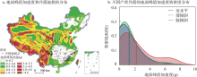
图9
地面峰值加速度对红层倾斜程度的影响
注:基于自然资源部标准地图服务网站审图号为GS(2019)1823号的标准地图制作,底图边界无修改。
Fig. 9
Impact of peak ground acceleration (PGA) on inclination of strata in Danxia sites
需要指出的是,岩层产状是沉积之后构造变形的累积,它与当今峰值地面加速度之间的关系本质上反映中国现今地壳变形是新构造运动变形的表现和继续。
6.3 岩石强度对崖壁高度的影响
图10
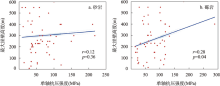
图10
单轴抗压强度与构造活动对崖壁高度的影响
Fig. 10
Impact of uniaxial compressive strength and tectonics on cliff height
根据戴维斯侵蚀旋回学说,地貌发育要素包括构造、侵蚀阶段和营力[87]。地貌演化反映三者之间的函数关系,岩石强度仅影响地貌营力的作用,所以岩石强度和崖壁高度关系较弱。
6.4 植被和气候影响地貌过程和美感
中国丹霞景观在除寒温带针叶林区域外的所有植被类型区均有分布(图11)。不同植被类型与丹霞地貌的结合,产生不同的美感,例如东南部和川渝黔边区丹崖和东部亚热带常绿阔叶林色彩对比强烈,形成秀美的丹霞景观。“天山—祁连”沿线主要位于暖温带荒漠区域,呈现出粗犷荒凉的美感。青藏高原丹崖和高原高寒草甸、草原的组合别具特色。此外,湿润区的藻类、地衣和苔藓等植物的生长会明显改变崖壁颜色。
图11

图11
不同植被区的丹霞地貌分布
注:基于自然资源部标准地图服务网站审图号为GS(2019)1823号的标准地图制作,底图边界无修改;① 东南部丹霞景观区,② 川渝黔边区丹霞景观区,③ 鄂尔多斯高原丹霞景观区,④ 鄂尔多斯盆地西南缘丹霞景观区,⑤ “天山—祁连”沿线丹霞景观区,⑥ 青藏高原丹霞景观区;中国植被区划底图来自廖克[40]。
Fig. 11
Distribution of Danxia sites versus vegetation regionalization
东南部和川渝黔边区为亚热带季风气候区,崖壁上多流水侵蚀形成竖向沟槽,河流下蚀强烈。青藏高原东北部地区全新世以来为干旱高寒气候[88],作为主要地貌营力的寒冻剥蚀导致丹霞地貌坡面较缓,崩积物少见。在鄂尔多斯高原西南部,干旱气候使崖壁中厚层石膏的存在成为可能。总体上,气候主要影响地貌过程,同时塑造了丹霞景观的坡面形态。
7 丹霞景观异质性因素的影响机制
丹霞景观的影响因素往往耦合在一起,在对各异质性因素分析基础上,以喜马拉雅运动、盆地类型、气候、演化阶段和其他自然地理要素等5个影响因素为背景,通过大尺度区域对比,确定其对丹霞景观空间分异的影响(图12)。
图12
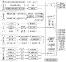
图12
各影响因素对丹霞景观分异的影响
Fig. 12
Driving factors in the differentiation of Danxia landscapes
东南部和川渝边区与“天山—祁连”沿线处于不同气候区,对比其丹霞景观发现,湿润区主要为流水下蚀和崩塌作用,而干旱区主要为盐风化、冻融风化等物理风化作用,气候影响地貌过程(图12c)。不同地貌过程也影响坡面形态,如干旱区崖壁常见因风化形成的风蚀壁龛。
鄂尔多斯高原、川渝边区岩性较为一致,鄂尔多斯高原处于幼年期,基本为沟谷型丹霞,地貌类型单一。通过东南部处于不同演化阶段的丹霞景观的对比发现,青年早期丹霞地貌峡谷、巷谷密集,负地貌多样,而壮年期和老年期丹霞单体和群体景观丰富。对于以水蚀为主的大型丹霞地貌区,地貌演化阶段影响单体和群体的景观类型丰富程度(图12d)。此外,对比发现,属于构造成因的“天山—祁连”沿线丹霞(背斜)不符合戴维斯侵蚀旋回的整体快速抬升的假定,无法确定其地貌演化阶段。
8 结论
丹霞地貌分布的密集区是对相关地区喜马拉雅运动阶段地表隆升的响应,沉降区红层大多被掩埋,丹霞地貌数量少。红层沉积范围和喜马拉雅运动表现形式(隆升还是沉降)共同控制了中国丹霞地貌的空间分布格局。
本文通过半定量方式,确定中国丹霞景观特征在空间上表现出显著分异,并将其划分为东南部、川渝黔边区、鄂尔多斯高原、鄂尔多斯盆地西南部、“天山—祁连”沿线、青藏高原地区6个各具特色的丹霞景观片区。
通过各区域丹霞景观对比,发现丹霞景观空间分异主要由喜马拉雅运动、盆地类型、气候、演化阶段、其他自然地理要素等共同控制。具体表现为,喜马拉雅运动中不同区域的构造特征控制岩层产状及丹霞地貌的密集程度;不同盆地岩性差异影响坡面形态;气候影响地貌过程,同时对坡面形态也有影响;地貌演化阶段影响单体和群体景观的丰富程度;其他自然地理要素,诸如植被类型、石膏层、黄土覆盖和喀斯特石林等影响丹霞景观的特色。
本文还发现,红层岩石单轴抗压强度变异很大,同一崖壁上岩石强度的显著变异会导致差异风化,影响坡面形态和地貌过程,而不同区域岩石强度的大小对崖壁高度影响不显著。
参考文献
A review of the research on red beds and Danxia landform
DOI:10.11821/dlxb201309002
[本文引用: 2]

In the context that China Danxia landform went into the world and began the research of a new phase, it is necessary to make a review on the research progress of red beds and Danxia landform in and outside China. It is revealed that the domestic study was focused on the characteristics of red beds, engineering geology, features of Danxia landform and the basic problems of development. In general, in China there were no integrated studies of red beds concerning the field of geology and geomorphology, and the differences between lithologic characteristics of red beds and their related geomorphic development processes under the influence of exogenetic force were not well understood. However, research outside China were limited in the field of geology, and relevant studies of red beds and Danxia landform were conducted in the field of sandstone landform, with a microscopic, quantitative and experimental analysis. This paper suggests that most of the existing studies on red beds and Danxia landform were focused on single factor, and lack of subject system, and the integration of related subjects was also insufficient. Then, a new agenda for the future research was put forward, in which a clear discipline classification of red beds and Danxia landform and further basic research should be made, and the integration of related subjects, international communication and the global comparative research should also be strengthened.
国内外红层与丹霞地貌研究述评
DOI:10.11821/dlxb201309002
[本文引用: 2]
在中国丹霞地貌走向世界,开始一个新的发展阶段的时候,回顾并评述国内外红层和丹霞地貌的研究进展十分必要。国内在该领域的研究长期集中在红层特性、工程地质、丹霞地貌特征及发育的基本问题等方面,但对红层的地质和地貌融合研究不足,对不同红层的岩性差异及其在外动力条件下的地貌表现和地貌发育过程缺乏深度研究;国外还没有红层地貌和丹霞地貌的专门研究,学者们主要关注红层形成的地质背景,有关红层地貌的研究多分散在砂岩地貌中,但其在微观、定量、实验研究方面值得借鉴。本文认为当前有关红层和丹霞地貌的研究大多为单因子研究,缺乏系统的思想方法,各学科研究存在多张皮的问题。提出应明确红层和丹霞地貌的学科归属,深化基础研究,加强各学科之间的融合,并推动国际交流和对比研究。
Geology of Gongshui Basin in Jiangxi
江西贡水流域地质
A basic scenario of Danxia cliff development
丹霞地貌坡面发育的一种基本方式
On the spatial pattern of Danxia landform in China
DOI:10.11821/xb200501005
[本文引用: 2]
Danxia landform as a special geomorphic type is distributed in most parts of China. According to its spatial distribution patterns and regional differences, three major Danxia landform concentrated areas in China are identified in this paper. They are southeast area (including Jiangxi, Fujian, Zhejiang, Hunan and Guangxi provinces), the southwest area (the transitional zone of Yunnan-Guizhou Plateau and Sichuan Basin) and the northwest area (including Longshan mountain and both sides of the Huanghe River and its anabranches). The geologic and geographic conditions of Danxia landform and their differences of the three areas are analyzed. The Danxia geomorphologic landscapes, such as upright-shaped peaks, Danxia mesa, stone wall, cave and vertical cave, Danxia natural bridge, "a narrow strip of sky" and so on, are generally formed in the southeast area. The landscape of southwest area is characterized by Danxia escarpment face, waterfall and waterfall groups. The special landscapes in arid areas are found in the northwest area, for example, the mud-coating type, columniation type and board type of Danxia landforms, however there are more differences here than in the other two areas because of the complexity of the nature including the climate, running water, wind abrasion, the loessial cover and relevant elements and so on. Based on the tectonic uplift rates, regional structure of sedimentary red-basin, the fluvial process, weathering and biological processes, gravity and other internal gravitation and external processes in each Danxia landform area in China, this paper discusses the causes which control the differences and also explains the landscapes formation process and its mechanism.
中国丹霞地貌空间格局
Study on distribution of Danxia landform in China (First)
中国丹霞地貌分布(上)
Distribution of Danxia landform in China (Last)
中国丹霞地貌分布(下)
Discussion on spatial distribution of Danxia landform in China
中国丹霞地貌空间分布的探讨
Definition and classification of Danxia landform
丹霞地貌的定义及分类
The tectogenesis control of Danxia landform in southeast China
中国东南部丹霞地貌的区域构造控制
Red bed landforms in southeastern China
中国东南部红层地貌
Red bed landforms in southeastern China (continued)
中国东南部红层地貌(续)
Red bed landforms in southeastern China and its utilization and transformation
中国东南部红层地貌及其利用和改造
The ecological ravine effects of Danxia landform
DOI:10.1016/S1872-2032(08)60063-3 URL [本文引用: 1]
丹霞地貌沟谷生态效应
The ecological effect on the hilltop of Danxia landform
DOI:10.1016/S1872-2032(08)60073-6 URL [本文引用: 1]
丹霞地貌山顶生态效应
On the cliff culture of Danxia landform
丹霞地貌崖文化初探
Research on the relation of overhanging coffin with Danxia landform
悬棺葬及其与丹霞地貌的关系
The spatial patterns of red beds and Danxia landforms: Implication for the formation factors, China
This research examined the distribution features of red beds and 1,100 Danxia landform sites across China, while probing the relationship between these spatial patterns and geological elements. This study is based on geological and tectonic maps of China. ArcGIS software was used to process the adjacent index, then perform a spatial analysis of Danxia landforms and red beds, and a coupling analysis of Danxia landforms and red beds with tectonics. Based on a point pattern analysis of Danxia landforms, the adjacent index is 0.31, and the coefficient of variation verified by Thiessen polygon reaches 449%. These figures reflect the clustered distribution pattern of the Danxia landforms. Across the country, Danxia landforms are concentrated into three areas, namely, the Southeast China region, the Sichuan Basin region and the Qilian-Liupan region. The exposure of red beds covers 9.16 × 10⁵ km2, which accounts for 9.5% of the total land area of China. With this research background, the geological elements of tectonics and their effects on the distribution, number, and spatial pattern of Danxia landforms and red beds were analyzed.
Land degradation and management of red beds in China: Two case studies
DOI:10.1007/s11629-019-5560-2 [本文引用: 1]
Distribution, characteristics and evolution of Danxia landform in Qinghai
青海丹霞地貌的分布、特征及演化
Development of Danxia landform in Jiangxi Province and its regional planning for tourism
江西省丹霞地貌发育规律及旅游区划研究
Characteristics of Danxia landform in Gansu and its development on tourism
甘肃丹霞地貌的特征及其旅游开发
Danxia landform and its tourism resource in the west central Zhejiang Province
浙江省中西部地区丹霞地貌特征及其旅游资源
Cognitive roadmap of Danxia landform definition
DOI:10.12339/j.issn.1673-8578.2021.03.002
[本文引用: 1]
At the 7th International Geomorphology Congress in 2009, IAG Danxia geomorphology working group was proposed by the president of the Congress and approved by the International Association of Geomorphologists. In 2010, the 34th World Heritage Conference “China Danxia” successfully applied for the world heritage. These two events marked that China’s native Danxia landform went to the world and stepped on the international academic stage. However, the original definition of Danxia landform is lack of professional and normative scientific expression, which leads to improper cognitive misunderstanding, and leads to many disputes in the later study of Danxia landform and the inability of global comparison and exchange. Based on analyzing the professional defects of the definition of Danxia landform and the expression terms easy to be misunderstood, removing the false from the original definition by using the scientific abstract method and cognitive roadmap, extracting the essential characteristics and rules of Danxia landform by the procedure of “separation purification brevity”, we put forward a scientific definition of Danxia landform that is suitable for global comparison: water erosion is the main factor, while water erosion is the main factor under the combined action of external forces such as collapse, weathering and dissolution, the red bed landform is characterized by the combination of steep slopes.
丹霞地貌定义的认知路线图
DOI:10.12339/j.issn.1673-8578.2021.03.002
[本文引用: 1]
2009年第7届国际地貌学大会上,由大会主席提议,国际地貌学家协会批准设立“IAG丹霞地貌工作组”。2010年第34届世界遗产大会“中国丹霞”成功申遗。这两大事件标志着中国土生土长的丹霞地貌走向了世界,登上了国际学术舞台。但是,丹霞地貌提出的原定义缺乏专业规范的科学表述,产生了不应有的认知误区,引起了后期丹霞地貌研究的诸多争议与国际地貌学界无法进行全球对比交流等弊端。文章梳理了丹霞地貌定义的专业缺陷、容易产生误解的术语及误区,运用科学抽象方法与认知路线图,对原定义去伪存真,遵循“分离—提纯—简化”的程序提取了丹霞地貌的本质特征和规律,提出了适用于全球对比的丹霞地貌科学定义:以流水侵蚀为主,并在重力崩塌、风化、溶蚀等外营力综合作用下,形成的以陡崖坡为坡面特征的红层地貌。
Definition, classification, and danxianization of Danxia landscapes
丹霞地貌定义、分类及丹霞作用研究
A survey of Danxia landform research in China
中国丹霞地貌研究进展
Rock resistance and the development of horizontal grooves on Danxia slopes
DOI:10.1016/j.geomorph.2010.07.002 URL [本文引用: 3]
Lithologic characteristics in Huoshi Village, Ningxia Province and the influence on the formation of Danxia landform
宁夏火石寨岩石岩性特征及其对丹霞地貌形成的影响
Anti-pressure experimental study on rocks in level Cave of Jinshiyan of Danxiashan in Guangdong Province
广东丹霞山洞穴景观岩体稳定性的抗压实验研究
Stone pillar rockfall in Danxia landform area, Mt. Langshan, Hunan Province, China
DOI:10.1080/02723646.2016.1218244 URL [本文引用: 2]
version of the Global Earthquake Model: Hazard component
DOI:10.1177/8755293020931866
URL
[本文引用: 1]
In December 2018, at the conclusion of its second implementation phase, the Global Earthquake Model (GEM) Foundation released its first version of a map outlining the spatial distribution of seismic hazard at a global scale. The map is the result of an extensive, joint effort combining the results obtained from a collection of probabilistic seismic hazard models, called the GEM Mosaic. Together, the map and the underlying database of models provide an up-to-date view of the earthquake threat globally. In addition, using the Mosaic, a synopsis of the current state-of-practice in modeling probabilistic seismic hazard at national and regional scales is possible. The process adopted for the compilation of the Mosaic adhered to the maximum extent possible to GEM’s principles of collaboration, inclusiveness, transparency, and reproducibility. For each region, priority was given to seismic hazard models either developed by well-recognized national agencies or by large collaborative projects involving local scientists. The version of the GEM Mosaic presented herein contains 30 probabilistic seismic hazard models, 14 of which represent national or sub-national models; the remainder are regional-scale models. We discuss the general qualities of these models, the underlying framework of the database, and the outlook for the Mosaic’s utility and its future versions.
The characteristics of intra-continental deformation and hydrocarbon distribution controlled by the Himalayan tectonic movements in China
DOI:10.1016/S1872-5791(07)60030-X URL [本文引用: 9]
中国喜马拉雅构造运动的陆内变形特征与油气矿藏富集
Remarks on some nonparametric estimates of a density function
On estimation of a probability density function and mode
Chen Zhijun. The discussion on the definition and classification to Danxia landform
丹霞地貌定义及分类中一些问题的探讨
Lithological control on the post-orogenic topography and erosion history of the Pyrenees
DOI:10.1016/j.epsl.2019.04.034
[本文引用: 2]
Numerous studies on active mountain ranges have demonstrated the interaction between tectonics and climate in shaping topography. Here we explore how variations in rock types have affected the topographic development of the Pyrenees since cessation of orogenesis ca. 20 Ma. Our study is based on a multidisciplinary approach and integrates topographic analyses, rock strength measurements and thermal modelling of low-temperature thermochronological data published across the Central Pyrenees. Results indicate a strong influence of rock strength in determining the post-orogenic morphology of the Pyrenees. We observe a correlation between rock strength and the normalized channel steepness index (k(sn)) of the different lithologies. Moreover, the highest topography is dominated by the Variscan plutonic massifs which have highest rock strength. Consequently, the drainage divide appears to track the position of these massifs. Abrupt deceleration of exhumation recorded in inverse modelling of low-temperature thermochronologic data suggests that the exhumation of the Variscan massifs also played role in lowering in erosion rates over the massifs during orogenesis. Crown Copyright (C) 2019 Published by Elsevier B.V.
Three-dimensional velocity field of present-day crustal motion of the Tibetan Plateau derived from GPS measurements
DOI:10.1002/2013JB010503 URL [本文引用: 1]
An analysis of principal features of tectonic evolution in south China Block
华南构造演化的基本特征
Late Mesozoic Basin and range tectonics and related magmatism in Southeast China
DOI:10.1016/j.gsf.2011.11.007 URL [本文引用: 2]
The relationship between uranium metallogenesis and crustal extension during the Cretaceous-Tertiary in south China
华南白垩—第三纪地壳拉张与铀成矿的关系
Mesozoic-Cenozoic basin features and evolution of southeast China
DOI:10.1111/acgs.2007.81.issue-4 URL [本文引用: 1]
Geological features and tectonic evolution of Meso-Cenozoic basins in southeastern China
中国东南部中、新生代盆地特征与构造演化
Late Mesozoic and Cenozoic rifting and its dynamic setting in Eastern China and adjacent areas
DOI:10.1016/S0040-1951(01)00271-2 URL [本文引用: 2]
Exhumation and landscape evolution in eastern South China since the Cretaceous: New insights from fission-track thermochronology
Features of the thrust wedge of deformation belt in Kuqa rejuvenation foreland basin
Kuqa rejuvenation foreland basin and its thrust wedge of foreland deformation belts are structurally responsed to the India-Eurasia collision in the interior of Asia continent Based on the detailed surface geology reconnaissance and interpretations of many seismic profiles, we conclude that thrust wedge of deformation belt in Kuqa rejuvenation foreland basin is divided into five structural units, including the marginal thrust and hidden structural zone, the Shidike anticline zone, the North linear anticline zone, the Baicheng piggy-back depression and the Qiulitage thrust fronta1 zone.The fauult-related folds aye the basic deformation styles of the rejuvenation foreland thrust wedge, which are classified into nine kinds of fault-related folds, including fault-band fold, fault propagation fold, detachment kink fold, duplex, pop up, hybrid fault-bend/detachment fold, stacked anticline, composed wedge structure and superimposed fault-lend/fault-propagation fold In the northern part of the fiat/ramp thrust wedge, the fault-related folds are mainly of fault-bend folds, fault-propagation folds, and duplexes For the very front of the wedge there exist well developed blind thrusts and detachment kink folds, forming a typically cryptic thrust wedge front edge.Growth strata recorded accurately initial emplacement ages of every structure belt and detailed forming processes.Thrusts and thrust-related folds propagate from the north tothe south within the thrust wedge, i.e. Misibulake anticline initiated in the Miocene(23.3Ma), velocity of blind thrust 0.16mm/a; Kalabahe anticline and Kelasu anticline in 16.9Ma, velocity of hidden thrast 0.16mm/a and 0.16mm/a; Dawanqi anticline in 3.6Ma, velocity of hidden thrust 0.82mm/a: Dongqiulitage anticline in 3 Ma, velocity of blind thrust 1.3turn/a; and Yaken anticline in 1.87Ma, velocity of hidden thrust 3mm/a.The crustal shortening velocity which caused the thrusting is slow at about 0.355mm/a in average in the Miocene, then approaches O.82mm/a in middle Pliocene. During the late Pliocene and the Quaternary the velocity gets faster in about one magnitude order, up to 1.29-3mm/a, implicating that an accelerating crustal shorting process occurred in the late Cenozoic in the Kuqa thrust belt and approached a climax in the Pliocene and the Pleistocene.
库车再生前陆盆地冲断构造楔特征
库车再生前陆盆地冲断构造楔由一系列向南运动的逆冲断层和相关褶皱组成。冲断楔的北部以断层转折褶皱、断层传播褶皱、双重逆冲构造为主。断层楔的前缘发育了很好的滑脱膝折背斜,全为盲断层控制,形成隐蔽式前锋。冲断层的就位从中新世开始,自北向南迁移,前锋的构造形成在第四纪。造成逆冲断层的地壳水平缩短作用速度在中新世较慢,平均为0.355mm/a,上新世中期达0.82mm/a,而到上新世晚期和第四纪速度增大了约一个数量级,达到1.29-3mm/a。
Geometry and kinematics of the Kuqa fold-and-thrust belt in the southern Tianshan
南天山库车褶皱冲断带构造几何学和运动学
Timing of the Tianshan Mountains uplift constrained by magnetostratigraphic analysis of molasse deposits
DOI:10.1016/S0012-821X(04)00008-1 URL [本文引用: 2]
Eocene to Miocene out-of-sequence deformation in the Eastern Tibetan Plateau: Insights from shortening structures in the Sichuan Basin
DOI:10.1002/jgrb.v123.2 URL [本文引用: 2]
Extraordinary denudation in the Sichuan Basin: Insights from low-temperature thermochronology adjacent to the eastern margin of the Tibetan Plateau
A comparative study of the late Mesozoic uplifting in the eastern margin of Qinghai-Tibet Plateau and Sichuan Basin, China
青藏高原东缘及四川盆地晚中生代以来隆升作用对比研究
The late Cenozoic uplift of the Liupan Shan, China
晚新生代六盘山隆升过程初探
Lhasa-Qiangtang collision: Constraints from Late Cretaceous red beds in Asa, Tibet
拉萨—羌塘板块碰撞: 来自西藏阿索晚白垩世红层的约束
Identification of geological time of Mesozoic strata in Hefei Basin and its significance
合肥盆地中生界的地层时代判识及意义
An analysis on tectono-paleogeography of the Qaidam Basin, NW China
柴达木盆地构造古地理分析
Yaojia-Lower Nenjiang formations and lake evolution of southeastern Songliao Basin, NE China
松辽盆地东南区姚家组—嫩江组一段地层特征与湖泊演变
Deep continental scientific drilling engineering in Songliao Basin: Progress in earth science research
松辽盆地大陆深部科学钻探地球科学研究进展
Stratigraphic subdivision and correlation of the Mesozoic in the Bohai Bay Basin
渤海湾盆地中生代地层划分与对比
Late Mesozoic continental basin "Red and Black Beds" coupling formation constraints on the sandstone uranium mineralization in northern China
中国北方晚中生代陆相盆地红—黑岩系耦合产出对砂岩型铀矿成矿环境的制约
Paleomagnetic study of the Mesozoic and Cenozoic bore hole in north Tarim Basin: Himalayian remagnetization and hydrocarbon migration and collection
塔里木盆地北部中、新生代钻孔岩芯古地磁研究: 喜山期岩石重磁化与油气移聚
Differential exhumation in response to episodic thrusting along the eastern margin of the Tibetan Plateau
DOI:10.1016/S0040-1951(97)00040-1 URL [本文引用: 1]
Late Cenozoic uplift and landscape evolution along the eastern margin of the Tibetan Plateau: Inferences from 40Ar/39Ar and (U-Th)/He thermochronology
Late Miocene (10.0 similar to 6.0 Ma) rapid exhumation of the Chinese South Tianshan: Implications for the timing of aridification in the Tarim Basin
Middle-late Miocene rapid exhumation of the southern Qilian Shan and implications for propagation of the Tibetan Plateau
Space-time coordinate of the evolution and reformation and mineralization response in Ordos Basin
鄂尔多斯盆地演化—改造的时空坐标及其成藏(矿)响应
Geodynamic environment and tectonic attributes of the hydrocarbon-rich sag in Yanchang Period of Middle-Late Triassic, Ordos Basin
DOI:10.18654/1000-0569/2020.06.17 URL [本文引用: 1]
鄂尔多斯盆地延长期富烃坳陷形成的动力学环境与构造属性
Crustal structure and deformation between different blocks in the northern part of the western margin of Ordos
鄂尔多斯西缘北段的地壳结构和块体间变形关系
The transfer of depocenters and accumulation centers of Ordos Basin in Mesozoic and its meaning
鄂尔多斯盆地中生代沉积和堆积中心迁移及其地质意义
Mesozoic geological events and its evolution sequence of the northern north-south tectonic belt, China
中国南北构造带北部中生代地质事件及其演化序列
Prototypes of Late Triassic sedimentary basins of North China Craton (NCC) and deformation pattern of its early destruction
华北克拉通晚三叠世沉积盆地原型与破坏早期构造变形格局
Spatial variation and controlling factors of deformation in the western segment of the southern Tianshan fold-thrust belt
南天山褶皱冲断带西段变形空间差异性及控制因素
Global dominance of tectonics over climate in shaping river longitudinal profiles
DOI:10.1038/s41561-021-00720-5 [本文引用: 1]
Growing topography due to contrasting rock types in a tectonically dead landscape
DOI:10.5194/esurf-9-167-2021
URL
[本文引用: 1]
. Many mountain ranges survive in a phase of erosional decay for millions of years following the cessation of tectonic activity. Landscape dynamics in these post-orogenic settings have long puzzled geologists due to the expectation that topographic relief should decline with time. Our understanding of how denudation rates, crustal dynamics, bedrock erodibility, climate, and mantle-driven processes interact to dictate the persistence of relief in the absence of ongoing tectonics is incomplete. Here we explore how lateral variations in rock type, ranging from resistant quartzites to less resistant schists and phyllites, and up to the least resistant gneisses and granitic rocks, have affected rates and patterns of denudation and topographic forms in a humid subtropical, high-relief post-orogenic landscape in Brazil where active tectonics ended hundreds of millions of years ago. We show that catchment-averaged denudation rates are negatively correlated with mean values of topographic relief, channel steepness and modern precipitation rates. Denudation instead correlates with inferred bedrock strength, with resistant rocks denuding more slowly relative to more erodible rock units, and the efficiency of fluvial erosion varies primarily due to these bedrock differences. Variations in erodibility continue to drive contrasts in rates of denudation in a tectonically inactive landscape evolving for hundreds of millions of years, suggesting that equilibrium is not a natural attractor state and that relief continues to grow through time. Over the long timescales of post-orogenic development, exposure at the surface of rock types with differential erodibility can become a dominant control on landscape dynamics by producing spatial variations in geomorphic processes and rates, promoting the survival of relief and determining spatial differences in erosional response timescales long after cessation of mountain building.\n
The geographical cycle
DOI:10.2307/1774538 URL [本文引用: 1]
The process and environment of Polaeokarst in the northeast area of Qinghai-Xizang Plateau
DOI:10.11821/xb199605003
[本文引用: 1]
The widespread distribution of karst landforms in the limestone area of Qinghai-Xizang Plateau in China has attracted attentions from geomorphologists. The preliminary study in the nonheast area of the Plateau indicates that the main types of karst include pinnacle karst, clints, limestone wall, cave and "widow-like cave", and etc.The results of fission track (FL) dating of recrystalized calcites in karst caves are 15.70 MaBP,12.19 MaBP,11.68 MaBP and 10.57 MaBP respectiwly(Tab. 4),Which are all in the mid-Miocene Epoch.The results from the analysis of relevant deposit,which is relic terra rossa or red regolith,reflect a kind of subtropical climate. The vahe of SiO<sub>2</sub>/Al<sub>2</sub>O<sub>3</sub> is about 3.30 (Tab.2),which is similar to that of the soils under subtropical. climate. X-ray diffraction analysis indicates that the average content of kaolimte in caly minerals is over 20%(Tab.3),even over 50% in some samples(such as Hx and Lms-1 and Mc-2). The quartz sand grains were studied under the ebctronic scanning microscope(SEM), some chemical modification features (Fig.2) on the grain surface indicate that the terra rossa was formed under warm and humid climate.Two main reasons contribute to the karst evolution in this area, they are the uplift of QinghaiXizang Plateau and the northwards shift of latitudinal zone since the Pliocene. The karst evolutioncan be divided into 3 slages(Fig.3),the first stage:intense karst process,the second stage:coutinning karst process, and the third stage: mechanical weathering and relic karst process.
青藏高原东北部古喀斯特过程与环境
DOI:10.11821/xb199605003
[本文引用: 1]
本文介绍了青藏高原东北部地区的古喀斯特现象,并对相关沉积进行了化学成分、粘土矿物的X-射线衍射以及石英砂表面结构等气候代用指标的分析。分析结果一致,指示了温暖湿润的亚热带气候条件。重结晶方解石的裂变径迹测年结果(15-8MaBP)表明,该地区古喀斯特发育于中中新世。后期随着青藏高原的抬升,原先覆盖型喀斯特遭剥蚀而裸露成地表喀斯特,并演化成目前仍保留着的状态。
