

1 引言
秦岭是中国南方和北方的自然地理分界线,其南北两侧的气候差异显著,其间广泛分布的黄土是记录古气候变化的良好载体[15-16]。秦岭地区山间盆地也是旧石器考古研究的重要区域,在此发现的大量沿河谷分布、埋藏于黄土和河流阶地中的旧石器遗存可追溯到约1.5 Ma,甚至约2.1 Ma[17⇓⇓⇓⇓⇓-23]。该地区是中国北方和南方古人类活动交流的重要区域,保存了中国早期人类南北迁徙路线的重要证据[19,24 -25]。汉江自西向东连通了秦岭山间的汉中、安康等盆地。追溯汉江上游盆地连通的过程、探究古人类是沿汉江河谷溯源而上,还是从南侧大巴山南北两侧溪流和古嘉陵江等流域进入南秦岭[25-26],可以为本文提供地貌过程影响古人类活动的典型案例。
图1
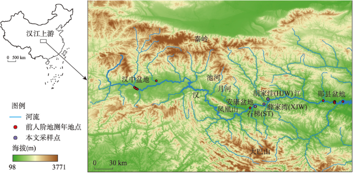
图1
秦巴山地汉江上游水系及采样点位置
注:基于自然资源部标准地图服务网站审图号为GS(2020)3183号的标准地图制作,底图边界无修改。
Fig. 1
Drainage in the upper reaches of the Hanjiang River in the Qinling and Daba mountains and locations of the studied sections
本文通过安康盆地汉江阶地填图、阶地沉积物源分析(锆石U-Pb年龄谱)和古地磁测试,获得了汉江上游安康盆地阶地的分布与高阶地的年代。通过安康盆地和汉中盆地阶地序列的对比,获得汉江自东向西袭夺的年代。在此基础上,结合流域内古人类遗址的分布,初步讨论了汉江流域地貌演化对古人类活动的可能影响。
2 研究区概况
3 研究方法
3.1 野外工作
图2

图2
安康盆地汉江阶地分布及典型河段河谷横剖面
Fig. 2
The distribution of terraces (a1, b1, c1) and the cross sections of the valley and terraces (a2, a3, b2, c2) of the Hanjiang River in the Ankang basin
图3
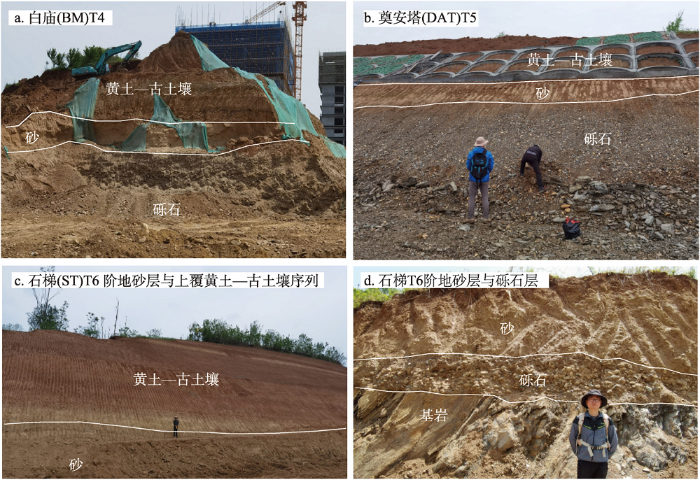
图3
安康盆地汉江高阶地及相关沉积
注:图片均由张丹枫于2021年4月拍摄。
Fig. 3
High terraces of the Hanjiang River at different sites in the Ankang basin
3.2 磁性地层学
在清理出的新鲜剖面,以约20 cm为间隔采集边长约10 cm厚的定向块状样品,在其上表面标记正北方向。实验室内,将块状定向样品通风晾干后,加工为边长为2 cm的小正方体,加工过程保证正方体的每条边与釆样时标注的方向平行或垂直。本文共采集样品118个,加工获得古地磁样品94块。
对所有样品测量天然剩磁后,分别按80 ℃、150 ℃、200 ℃、250 ℃、300 ℃、350 ℃、400 ℃、450 ℃、500 ℃、525 ℃、550 ℃、580 ℃、610 ℃、640 ℃等进行系统热退磁和剩磁测量。样品的古地磁测试在中国地质调查局天津地质调查中心古地磁实验室完成。样品使用TD-PGL-100热退磁炉加热退磁,使用美国2G公司低温超导岩石磁力仪(755R U-Channel)测量剩磁。所有退磁过程和剩磁测量均在零磁空间中进行。
3.3 沉积物粒度
所有样品的粒度测定在南京大学地貌与环境实验室完成。首先,取0.5~2 g样品置于烧杯中,加入10 mL 10%的H2O2浸泡2 h;然后,放置于电热板上加热,再次加入10%的H2O2直到烧杯中不再剧烈冒泡(即完全去除了样品中的有机质);加入10%的稀HCl至不再剧烈冒泡(即完全除去样品中的碳酸盐物质)后,加入蒸馏水不断冲洗至中性后冷却;最后,在烧杯加满蒸馏水静置12 h后,倒掉上清液,再加入10 mL 0.05 mol/L (NaPO3)6溶液作为分散剂,置于超声波振荡仪中振荡10 min后上机测试。测试仪器为英国 Malvern公司生产的Mastersizers 2000激光粒度分析仪,测量范围为0.02~2000 μm。粒度参数如平均粒径(Mz)、分选系数(Sd)、偏度(Sk)、峰度(Ku)采用GRADISTAT程序进行计算[37]。粒度端元模型采用基于MATLAB的AnalySize-1.1.2算法进行计算[38-39]。
3.4 锆石U-Pb年龄
样品经过淘洗、电磁选之后,在双目镜下随机挑选锆石,并制成环氧树脂锆石靶抛光。锆石年龄测试在南京大学地貌过程与环境实验室完成。利用New Wave 193 nm激光仪进行烧蚀,激光束直径为25 μm,重复频率为10 Hz,能量为2~3 J/cm²,通过Agilent 7700×电感耦合等离子体质谱仪(LA-ICP MS)测量。测试中使用91500标准锆石作为外部校正[40],用GJ-1标样检测仪器稳定性[41],用NIST610标样计算U、Th、Pb等元素含量。普通Pb校正采用Andersen方法[42],同位素比值及元素含量计算采用Gliter4.4.2软件[43],使用Isoplot4.15程序绘制锆石U-Pb年龄的概率谱图。年龄计算中,<1000 Ma锆石使用206Pb/238U年龄,>1000 Ma锆石用207Pb/206Pb年龄,选取年龄协和度90%~130%的年龄进行碎屑锆石年龄谱分析。
4 结果
4.1 阶地分布
4.2 ST剖面沉积物粒度特征
ST剖面沉积物粒度由4个端元组成(可覆盖99.6%的数据集方差,99.8%的样本中值方差,98.8%的样本低于95%方差)。4个粒度端元从细到粗为EM1、EM2、EM3、EM4(图4a)。其中EM1模态粒径约为2~10 μm,平均4 μm,可能来自远源粉尘[44-45],或者是本地强烈的风化成壤作用形成的细颗粒[46]。EM2的模态粒径为16~22 μm,是东亚地区第四纪以来黄土中的主要粒度端元之一[44-45]。EM3的模态粒径约为35~40 μm,与Van Buuren等揭示的黄土沉积中近源风沙组分一致[31]。EM4频率曲线为双峰分布,峰值分别为约150 μm和约13μm,可能代表河漫滩沉积[39,44 -45]。
图4
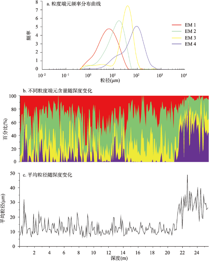
图4
ST剖面沉积物粒度组成及其变化特征
Fig. 4
Grain size composition and variation of the sediment sequence from the ST profile
沉积单元1深度2560~2080 cm,整体粒度偏粗,平均粒径大多在30 μm以上(图4),为河漫滩相沉积。该沉积单元粒度以EM4组分为主,平均占比达到约43.8%,特别是在剖面底部占比达到60%~70%。同时EM3和EM2的平均占比分别为20.9%和28%,变化幅度不大;而EM1的平均占比最低,只有7.3%。沉积单元1和沉积单元2的界限(河漫滩到风成黄土沉积环境的变化)在深度2080 cm处。
沉积单元2深度2080~1410 cm。EM4在该沉积单元的贡献率很低,平均占比仅有0.7%;EM3的贡献率较为稳定,平均占比约为23.4%;EM2的贡献率最大,平均占比约50.4%。同时该沉积单元中EM1的贡献率从下往上略有增加,平均占比约为25.5%,贡献率仅次于EM2。该沉积单元以远距离搬运的细粒风成物质为主,为典型的风成沉积。
4.3 磁性地层与黄土—古土壤序列
图5
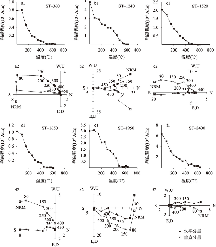
图5
ST剖面代表性样品磁化强度衰减曲线(a1~f1)和热退磁正交投影(a2~f2)
Fig. 5
Magnetization attenuation curves (a1~f1) and thermal demagnetization orthogonal projections (a2~f2)
of representative samples of the ST section
对ST剖面数据处理采用主成分分析法。为获得可靠的特征剩磁结果,本文采用下列准则筛选数据:① 每个样品选择向原点逐渐衰减的分量,且至少有4个温度的数据点;② 特征剩磁最大角偏差< 15°;③ 虚拟地磁极纬度>30°或<-30°。按此标准共筛选出58个古地磁样品。
ST剖面共包含4个极性段,分别为R1(0~12.5 m)、N1(12.5~13.7 m)、R2(13.7~20 m)、N2(20~25.6 m)(图6)。汉江安康段T4底部砂层年龄约为1.2 Ma[19],位于T6的ST剖面底部年龄应老于1.2 Ma。因此,位于该剖面底部的N2应与标准极性柱(GPTS)中的Olduvai极性亚时相对应,且R1和R2都属于松山负极性带(图6)。由于中国黄土沉积地层中未见Gardar、Gilsa等短时间地磁极性漂移[47]的报道;若N1对应Jaramillo极性亚时,则ST剖面沉积速率在此期间由8.9 m/Ma激增至14.8 m/Ma,是R2期间沉积速率的近两倍。这与黄土—古土壤剖面自上而下沉积速率均一[48]相矛盾。与上下沉积层相比,N1极性对应地层(深度12.5~13.7 m)中粗颗粒组分EM4占比明显持续偏高(图4),可能表明该时期地表片流改变了黄土沉积环境、带来粗颗粒物质,提高了沉积速率;这与该地区黄土沉积中夹杂间歇的片流沉积[31,39]一致。
图6
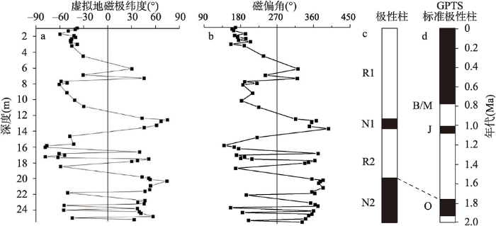
图6
ST剖面虚拟地磁极纬度、磁偏角、地磁极性柱和标准地磁极性柱
注:B: Brunhes;M: Matuyama;J: Jaramillo;O: Olduvai[47]。
Fig. 6
Virtual geomagnetic pole latitude, magnetic declination, geomagnetic polarity zonation of the ST section and GPTS
为了验证上述ST剖面的磁性地层结果,本文将ST黄土与宝鸡黄土—古土壤序列[49]进行了地层对比。Ding等将宝鸡黄土小于2 μm粒度组分与大于10 μm粒度组分含量之比作为冬季风强弱指标,建立了中国黄土高原黄土—古土壤旋回地层序列,并在黄土磁性地层的基础上,通过轨道调谐建立了黄土高原第四纪黄土的年代标尺[49]。考虑到粒度测定方法的变化与原地风化成壤作用的影响,Vandenberghe等用5~16 μm和16~44 μm的沉积物组分之间的比值(U值)来反映冬季风强弱的变化,并根据U值和黄土堆积速率的关系和年龄控制点推导获得了第四纪以来黄土沉积的年代标尺[50]。Lu等通过黄土地层磁化率曲线的轨道调谐年龄建立了洛川黄土的年代标尺[51]。此后,Heslop等基于黄土与海洋ODP677 N钻孔δ18O记录的对比和轨道调谐进一步完善了中国第四纪黄土的精细时间标尺[48]。由于汉江流域气候更加炎热潮湿,原地风化成壤作用更强[15-16],本文采用一定程度上排除了风化成壤作用对黄土粒度影响的U值(5~16 μm和16~44 μm沉积物组分的比值)[50]来反映冰期—间冰期尺度冬季风强度的变化,并与宝鸡黄土的粒度曲线进行了对比(图7)。考虑到T6之上ST剖面上覆的黄土地层底部应该老于T5上覆黄土底部地层(L15)[19,28],且ST剖面黄土—古土壤未见明显的侵蚀、以及该地区黄土地层基本连续沉积的特征[28],T6阶地上覆的黄土对应于宝鸡黄土剖面S15—L25的黄土—古土壤序列(图7)。其中对应于Olduvai的N2极性亚时上界位于L25黄土层中,这与中国黄土高原黄土—古土壤序列中Olduvai极性亚时位于L25—L27地层[48]相符。然而,Jaramilo极性亚时的下界位于S15以上[48],因此将极性段N1对应于Jaramilo极性亚时与粒度曲线对比结果矛盾。N1段附近(10~13 m)粒度曲线相对宝鸡剖面明显表现出较差的对应性,说明该段地层受到地表片流改造的影响更显著,并非完全的风成黄土。综合考虑粒度对比结果、沉积环境分析、沉积连续性与ST剖面未见明显侵蚀,最合理的解释是N1极性段可能是由沉积环境变化引起的黄土地层记录的假极性[52]。据此,本文推测片流带来的偏粗颗粒沉积可能导致了地层中记录的磁极性异常;当然这还需要更多的工作来证实。
图7
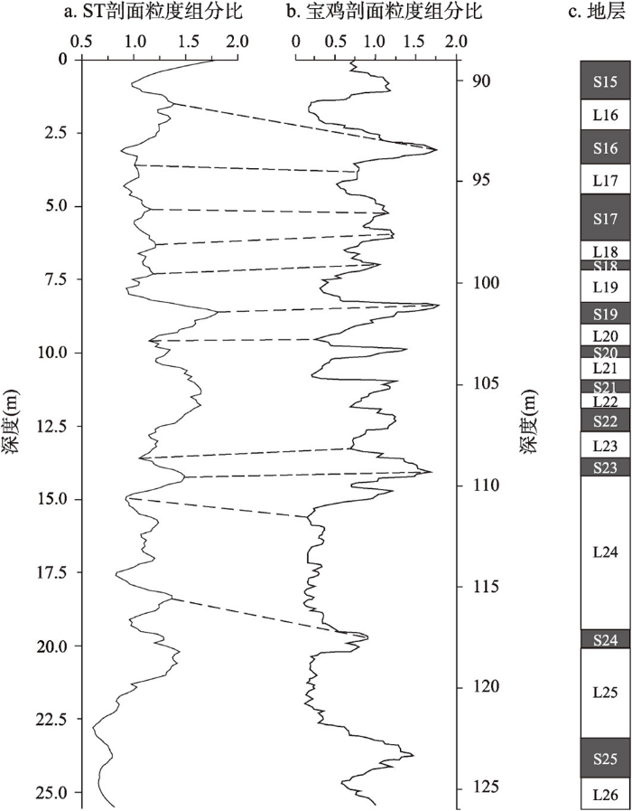
图7
ST剖面河流沉积与上覆黄土—古土壤粒度组分比(5~16μm/16~44μm)变化和宝鸡黄土—古土壤地层及粒度组分比(<2μm/>10μm)[49]
Fig. 7
Grain size ratio of fluvial sediments and overlying loess and paleosol (5~16 μm/16~44 μm) of the ST section and Grain size ratio (<2 μm/>10 μm) of loess and paleosol at the Baoji site
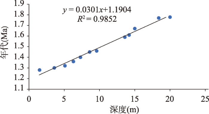
ST剖面黄土地层对应于黄土高原S15—L25的黄土—古土壤地层,根据黄土高原黄土地层轨道调谐建立的年代标尺[48],ST剖面上覆黄土的时代约为1.27—1.8 Ma。结合磁性地层对比获得的R2极性(Olduvai)开始年龄1.78 Ma和黄土年代标尺获得的S15—L25黄土层和古土壤层的年龄,线性内插获得ST剖面年龄和深度关系(图8)。由图8可知ST剖面河漫滩与风成黄土的界限(沉积单元1和沉积单元2的界线)的深度(2080 cm)对应的年龄为约1.82 Ma。ST剖面由河漫滩到上覆黄土粒度的渐变(粗颗粒组分EM4和EM3逐渐减少、细颗粒组分EM2和EM1逐渐增加,图4),与黄土堆积区河流侵蚀下切、沉积环境由低河漫滩沉积向高河漫滩沉积、风尘堆积逐渐转变的特征(无沉积间断)一致[39,53];黄土底部堆积年龄(1.82 Ma)即为阶地形成的年龄[53-54]。
图8
4.4 碎屑锆石U-Pb年龄
分别采自于3个高阶地(T6、T7、T8)的ST、XJW与HJW剖面中河流砂碎屑锆石 U-Pb 年龄谱都含有印支期(200—250 Ma)和晋宁期(700—900 Ma)两个显著的峰值(图9),以及极少量加里东期(400—505 Ma)。秦岭汉江上游地区印支期岩体主要分布在南秦岭汉中盆地以北区域,晋宁期岩体则主要分布在汉中盆地以南、大巴山和凤凰山区域,而加里东期岩体主要分布在凤凰山和大巴山地[26,55⇓⇓⇓⇓ -60]。由图9可知3个高阶地的锆石U-Pb年龄谱与安康盆地现代汉江沉积物锆石U-Pb年龄谱十分相似[26]。由于位于T6的ST剖面靠近加里东期岩体分布的凤凰山、大巴山地区(图1),晋宁期锆石含量在ST剖面的样品中略低,近源的加里东期锆石含量则明显高于其他样品;且研究区内印支期物质主要分布在上游汉中盆地以北。由此可推断安康盆地最高级阶地(T8)形成时汉江可能已经连通汉中和安康盆地,现代汉江自东向西的格局基本形成。
图9
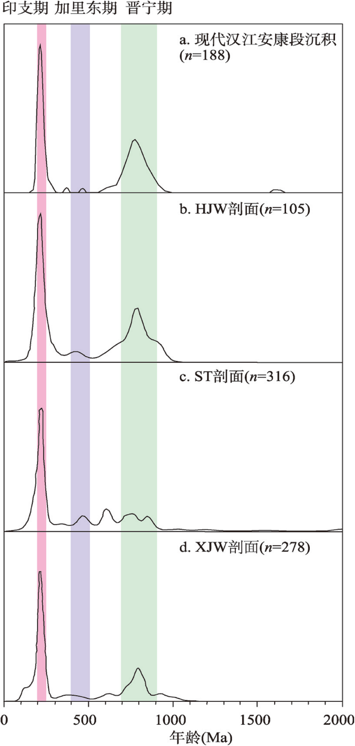
图9
不同剖面河流沉积物碎屑锆石年龄概率密度
注:现代汉江安康段沉积锆石年龄数据来自文献[26]。
Fig. 9
Probability density plots of detrital zircon ages from fluvial deposits from the modern Hanjiang River channels in Ankang, and at HJW site, ST site, and XJW site
5 讨论
5.1 汉江上游阶地形成时间及其成因
为确定汉江上游阶地的形成原因,本文汇总了汉江1~6级阶地的形成时间。1级阶地的OSL测年结果证实:厚层风成黄土L1底部的年龄在25 ka,而剖面底部风成黄土—冲积砂交互层年龄范围在距今55—25 ka之间;这表明汉江1级阶地在距今55 ka前后开始出现,在距今约25 ka最终形成[27]。2级阶地上覆黄土—古土壤层、河漫滩相砂层样品的光释光测年结果显示:汉江上游2级阶地在距今220 ka左右开始出现,最晚于180 ka左右形成[32]。通过粒度端元分析、等时线埋藏年龄与黄土地层对比可知:T3从河流环境到风成环境的转变发生在625—693 ka之间,即汉江3级阶地最终形成时间约为625—693 ka[31]。结合古地磁测试结果与黄土地层对比,以上覆黄土—古土壤层的年龄下限为阶地形成的最晚年代,安康盆地T4b形成的最晚年龄约1.05 Ma,汉中盆地T4a、T5形成的最晚年龄分别为约0.78 Ma和约1.5 Ma[19,28]。此外,本文显示汉江6级阶地最终形成的年代为1.82 Ma。
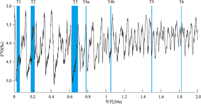
河流对气候变化响应敏感,气候变化可能影响河流阶地的形成和保存[61]。汉江上游阶地的形成年代与深海氧同位素曲线[62]的对比如图10。由图10可见,考虑到测年的误差,汉江上游阶地(如T6、T4b、T2和T1)大多形成于间冰期—冰期转换期,此后黄土—古土壤覆盖于河流阶地上。这与青藏高原东北部(如湟水流域)一致,季风气候及植被的变化,导致轨道时间尺度河流径流和泥沙量变化,且在间冰期—冰期转换期,流域适中的泥沙量供应导致河床不被完全覆盖、同时磨蚀增强,使得河流快速下切、形成阶地[63-64]。汉江T4形成于中更新世气候转型期(1.2—0.7 Ma),此时气候变化主导周期由40 ka转变为100 ka,且气候变化幅度加大[65](图10)。可能中更新世气候转型前较小的气候变化幅度以及较短的变化周期使得T5阶地发育之前难以形成和保存阶地[65-66]。世界各地河流阶地沉积的研究表明中更新世以来轨道尺度堆积—侵蚀过程和阶地的形成与100 ka气候周期密切相关,且中更新世气候变化幅度和周期的增加可能导致河流的侵蚀和堆积旋回加剧[7];这很可能是导致汉江上游1.2 Ma后更多级阶地形成和保存的原因。
图10
5.2 汉江自东向西袭夺的时间
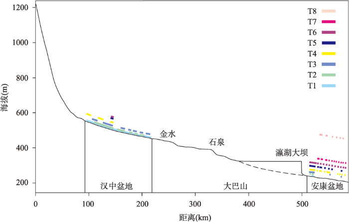
汉中、安康盆地汉江河流纵剖面和阶地的对比如图11所示。汉江河流纵剖面在金水、石泉、瀛湖有3个明显的裂点(瀛湖处的裂点可能与瀛湖水库大坝有关,不是自然形成的裂点)(图11)。汉江阶地从上游到下游的分布基本与现代河流纵剖面平行(图11),表明在阶地的形成过程中,汉江整体逐步下切;并且在两个盆地中都发育的T5以来的阶地纵剖面上都存在裂点,可能反映了同一级阶地逐步从下游向上游发育。从汉中盆地到下游安康盆地阶地数量、相邻阶地海拔高差都增加(图11),也证实了河流裂点溯源侵蚀、阶地自下游向上游逐渐形成的过程[68-69]。安康盆地保留的阶地级数为8,明显多于汉中,且安康附近保留的阶地以T4及以上的高阶地为主,而汉中则是T1、T2、T3分布广泛(图11)。T4在汉中与安康的拔河高度均为约40 m,但在安康的形成年龄略早于汉中[19],也表明了T4阶地自东向西、逐渐形成的过程。T5与T6的拔河高差在汉中为约10 m,而在安康为22.5 m,且安康盆地T5以上阶地的高程间距有增加的趋势,同时级数越高的阶地保存越少,分布越破碎。虽然金水到安康阶地的分布和对比关系还不清楚(图11),但上述汉中盆地和安康盆地阶地对比的关系初步证实了汉江自东向西逐渐袭夺[26]、阶地逐渐发育的过程。汉江袭夺贯通安康盆地和汉中盆地的时间应该老于各自盆地中最高阶地的年代,分别为>1.8 Ma(T8)和>1.2 Ma(T5)。这与汉江在早更新世将南秦岭物质带入江汉盆地的观点[33]相一致。
图11
5.3 汉江上游盆地连通对古人类活动的影响
图12
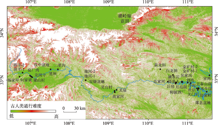
表1 汉江流域旧石器遗址点的位置及含石器黄土地层与年代[19,72⇓⇓⇓⇓⇓⇓⇓ -80]
Tab. 1
| 研究区域 | 遗址点 | 旧石器所在层位测年结果 | 旧石器所属黄土地层 | 遗址所在阶地 |
|---|---|---|---|---|
| 汉中盆地 | 窑厂湾 | 约600 ka | S5 | T3 |
| 龙岗寺 | 100 ka、600 ka、700 ka、 800—900 ka、1200 ka | S1、S5、S6、 S7、S8、L9、S9、L15 | T3、T4 | |
| 何家梁 | 约86 ka | S1 | T2 | |
| 杨家坪 | 115—73 ka | S1 | T2 | |
| 梁山村 | 191—140 ka | L2 | T2 | |
| 二里沟 | 126—107 ka | S1 | T2 | |
| 联丰-1 | 145—65 ka | L1、L2 | T2 | |
| 联丰-2 | 172—114 ka | S1、L2 | T2 | |
| 笵坝 | 172—25 ka | L2、S1、L1 | T2 | |
| 安康盆地 | 吴台村 | 980—950 ka | S9 | T4 |
| 关庙 | T2 | |||
| 曲家河 | 132—101 ka | S1、L2 | T2 | |
| 池河-1 | 151—106 ka | S1、L2 | T2 | |
| 池河-2 | 157—111 ka | S1、L2 | T2 | |
| 郧县盆地 | 黄龙洞 | 100—57 ka | S1 | |
| 白龙洞 | 约760 ka | |||
| 后房 | 约85.3—185.5 ka | S1、L2、S2 | T2 | |
| 滴水岩 | 约100 ka | S1 | T2 | |
| 郧县人 | 800—785 ka、936 ka | S9 | T4 | |
| 北泰山庙 | T3 | |||
| 金矿村-1 | 167—80 ka | S1、L2 | T2 | |
| 金矿村-2 | 149—78 ka | S1、L2 | T2 | |
| 刘湾 | T3 | |||
| 水牛洼 | T3 | |||
| 杜店 | T3 | |||
| 宋湾 | T3 | |||
| 舒家岭 | T3 | |||
| 肖家河 | T4 | |||
| 柳陂酒厂 | 150—130 ka、780—710 ka | S1、L2、S7 | T3 | |
| 吴家沟 | 780—710 ka | S7 | T3 | |
| 关门岩 | 约787—819 ka | L8 | T4 | |
| 月亮湖 | 约819—865 ka、约943—989 ka | S8、S9 | T4 |
自中更新世以来,秦岭地区发现的旧石器遗址最高海拔可达1200 m[70],因此定义在1200 m以下的区域为古人类容易到达的位置。结合中更新世以来东秦岭的隆升速率,选取可能抬升的最大值480 m[67],定义高程范围1200~1680 m为古人类的可能活动区,将高程范围1680 m以上的区域定义为古人类不可能到达、或者活动极少的地区。秦岭地区的古人类遗址大多位于起伏平缓的河谷、盆地和低矮的丘陵[25],因此推断坡度对古人类遗址分布有重要影响。鉴于北秦岭蓝田地区从早中更新世至末次冰盛期有着连续的古人类活动记录[71],因此可以以蓝田地区为参考,推测秦岭地区古人类活动的坡度。因为中更新世以来的古人类在蓝田地区横岭塬上自由活动[71],所以易通行坡度范围应覆盖横岭塬地区地形坡度(图12);同时其所涵盖范围还应尽量避免包含河谷或冲沟两侧较为陡峻的区域。据此,定义坡度0~15°为古人类容易通行的范围,15°~17.5°为可能通行的范围,17.5°以上为难以通行的坡度。
汉江上游地区的水系演化过程可能为认识中国早期古人类活动与地貌和水系演化之间的关系提供重要信息。结合古人类遗址分布与地貌特征(图1、图12)可知,汉江流域东西向水系格局的建立[26]连通了相对宽阔、平缓的山间盆地(古人类通行难度指标值低),可能为古人类沿东西向河谷进入秦巴山间盆地提供了便利的地貌条件。结合安康盆地汉江高阶地的年代与锆石U-Pb年龄反应的物源,推测秦岭古人类活动可能与区域水系格局和东西向汉江发育过程具有一定的联系:① 早期,秦岭南麓发育北—南向横向古水系[26],河谷狭窄、陡峭,古人类通行难度指标值高(图12),古人类不易通行;② 之后,西—东流向的汉江由东向西逐步袭夺北—南向河流,在1.8 Ma以前袭夺、连通安康和汉中盆地,形成相对宽阔、平缓,古人类通行难度指标值低的东西向河谷(图12);③ 1.5 Ma后,安康和汉中等盆地中形成多级阶地,这样古人类可沿着东西向水系,梯次进入秦岭山间盆地,并在之后发育的多级阶地上获得充足的活动空间。
6 结论
本文通过野外调查、黄土地层和磁性地层分析,确定了汉江上游阶地的分布以及安康盆地高阶地的形成年代,并通过高阶地和现代河流沉积碎屑锆石U-Pb年龄,以及安康盆地和汉中盆地阶地的对比,确定了现代汉江袭夺、自东向西水系格局形成的最晚时间,探究了阶地与水系格局对古人类分布的影响。归纳起来,主要结论如下:
(1)汉江在安康盆地发育了八级阶地,其中第六级阶地形成于约1.82 Ma;
(2)汉江上游各级阶地形成于间冰期—冰期转换期,此后阶地被风成黄土—古土壤覆盖。在约1.2 Ma后,由于中更新世气候变转型和秦岭抬升速率增加,汉江上游形成了级数更多、年代更为接近的阶地序列;
(3)现代汉江自东向西格局的形成不晚于1.82 Ma,早于汉江流域最古老的旧石器遗址年代(约1.5 Ma);此时河流袭夺连通山间盆地,可能为古人类沿宽阔河谷进入秦巴山地提供了便利的地貌条件;此后形成的多级阶地为古人类提供了广阔的活动空间。
关联数据信息:本文关联实体数据集已在《全球变化数据仓储电子杂志(中英文)》出版,获取地址:
参考文献
Transient fluvial incision in the headwaters of the Yellow River, northeastern Tibet, China
Stream-power incision model and its implications: discussion on the urgency of studying bedrock channel across the Tibetan plateau
基岩河道河流水力侵蚀模型及其应用: 兼论青藏高原基岩河道研究的迫切性
Characterizing the transient geomorphic response to base-level fall in the northeastern Tibetan Plateau
DOI:10.1002/jgrf.v122.2 URL [本文引用: 1]
Geomorphic indices and longitudinal profile of the Daba Shan, northeastern Sichuan Basin: Evidence for the late Cenozoic eastward growth of the Tibetan Plateau
Timescales, climate and river development
DOI:10.1016/0277-3791(95)00043-O URL [本文引用: 1]
The relation between climate and river processes, landforms and deposits during the Quaternary
DOI:10.1016/S1040-6182(01)00098-2 URL [本文引用: 1]
Climatically controlled river terrace staircases: A worldwide Quaternary phenomenon
DOI:10.1016/j.geomorph.2006.12.032 URL [本文引用: 2]
Evaluating the role of climate and tectonics during non-steady incision of the Yellow River: Evidence from a 1.24 Ma terrace record near Lanzhou, China
DOI:10.1016/j.quascirev.2009.09.003 URL [本文引用: 1]
Fluvial terraces and their implications for Weihe River valley evolution in the Sanyangchuan Basin
DOI:10.1007/s11430-016-5037-8 URL [本文引用: 1]
Longitudinal to transverse drainage network evolution in the High Atlas (Morocco): The role of tectonics
Mechanism and age estimates of continental-scale endorheic to exorheic drainage transition: Douro river, Western Iberia
River terrace systems in north-west Europe: An archive of environmental change, uplift and early human occupation
DOI:10.1016/S0277-3791(99)00095-5 URL [本文引用: 1]
Records of human occupation from Pleistocene river terrace and aeolian sediments in the Arneiro depression (Lower Tejo River, central eastern Portugal)
DOI:10.1016/j.geomorph.2012.02.017 URL [本文引用: 1]
Dating the earliest human occupation of Western Europe: New evidence from the fluvial terrace system of the Somme basin (Northern France)
DOI:10.1016/j.quaint.2014.08.012 URL [本文引用: 1]
Tectonic uplift-influenced monsoonal changes promoted hominin occupation of the Luonan Basin: Insights from a loess-paleosol sequence, eastern Qinling Mountains, central China
DOI:10.1016/j.quascirev.2017.05.025 URL [本文引用: 2]
Influence of tectonic uplift of the Qinling Mountains on the paleoclimatic environment of surrounding areas: Insights from loess-paleosol sequences, Weihe basin, central China
Preliminary observation of Liangshan Paleolithic site
梁山旧石器遗址的初步观察
Current perspectives on Paleolithic archaeology in the Upper Hanjiang river valley, central China
秦岭南麓汉水上游旧石器考古研究现状与契机
Early human settlements in the southern Qinling Mountains, central China
DOI:10.1016/j.quascirev.2017.04.005 URL [本文引用: 15]
Hominin distribution in glacial-interglacial environmental changes in the Qinling Mountains range, central China
DOI:10.1016/j.quascirev.2018.08.012 URL [本文引用: 1]
New evidence of a lithic assemblage containing in situ Late Pleistocene bifaces from the Houfang site in the Hanshui River Valley, Central China
DOI:10.1016/j.crpv.2015.12.005 URL [本文引用: 1]
Lithic artifacts excavated from Locality 3 of the Longgangsi site in Hanzhong basin, Shaanxi province
汉中盆地龙岗寺遗址第3地点出土的石制品
Hominin occupation of the Chinese Loess Plateau since about 2.1 million years ago
DOI:10.1038/s41586-018-0299-4 [本文引用: 1]
Taphonomic and paleoenvironmental issues of the Pleistocene loessic Paleolithic sites in the Qinling Mountains, central China
DOI:10.1007/s11430-016-5298-4 URL [本文引用: 2]
Earth surface processes and their effects on human behavior in monsoonal China during the Pleistocene-Holocene epochs
DOI:10.1007/s11442-017-1437-x
[本文引用: 3]

There is a wide diversity of landforms in China. The topography of three major terraces, decreasing in height stepwise from west to east, was formed by the early Miocene. With the commencement of the Great Northern Hemisphere Glaciations (GHGs) and the glacial-interglacial cycles in the Pleistocene, thick loess deposits accumulated in north China, and fluvial terraces were formed and lakes expanded and contracted in eastern and central China. The earliest evidence of hominins in China is dated to ~1.7 Ma; they occupied the monsoon-dominated region for a long interval, until the late Pleistocene, ~50 ka. In this study, we investigated a large area rich in the relics and artifacts of early man. The results indicate that the early humans occupied riverine areas, especially medium-sized fluvial basins, and lake shores. Even in the relatively recent geological past, the occupation and abandonment of settlements were directly forced by the shifting of sand dune fields in the desert-loess transitional zone, which in turn was closely associated with variations in the monsoon climate and vegetation patterns. Our observations indicate that landforms were one of the main determinants of early human behavior, in that loess tableland, large alluvial plains, desert-Gobi areas, and the Tibetan Plateau, were not suitable environments for early human settlement. We infer that the early humans in China adapted their behavior to specific landforms and landform processes. The monsoon climate, which shapes the large-scale step-like pattern of fluvial landforms, promotes vegetation coverage and dominates soil formation, provides a crucial context for early human adaptation. The adaptation of early humans to earth surface processes in East Asia is investigated for the first time in this study. Future investigations will provide further information that will increase our understanding of the linkage between early human behavior and landform processes in East Asia.
Drainage evolution in intermontane basins at the Qinling-Daba Mountains
DOI:10.1007/s11430-020-9820-y [本文引用: 8]
Eolian loess-palaeosol sequence and OSL age of the first terraces within the Yunxian Basin along the upper Hanjiang river
DOI:10.11821/dlxb201501005
[本文引用: 3]
The first river terrace within the Yunxian Basin along the upper reaches of Hanjiang River was investigated in the field work. The sediment profiles were sampled systematically. The sedimentological characteristics, and physical and chemical properties were analyzed in laboratory. The samples were dated using OSL method. The results show that, the bottom age of the thick loess L1 is 25 ka BP, and the age range of the eolian loess-alluvial sand inter-beds (T1-al2) is between 55-25 ka BP. The age distribution suggests that deposition process of the loess sequence in Hanjiang River valley is essentially continuous. The first river terrace of the Hanjiang River has experienced two development stages, including the tectonic uplift and river incision (55-25 ka BP), and then the stabilized eolian loess deposition (25-0 ka BP). Around 55 ka BP, the river incision started because of the intensified tectonic uplifting. The eolian loess accumulation on the uplifted flood plain was frequently interrupted due to the overbank flooding. This process continued around 25 ka BP and the inter-beds of eolian loess and alluvial sand (T1-al2) were therefore formed. To about 25 ka BP, the first river terrace had formed and eolian loess accumulated continuously on the terrace land. At the same time, with the river incision, the last glaciation entered the maximum stage and the thickeolian loess covered the terrace because of the increased dust storms and dustfalls. Since the formation of the terrace about 25 ka BP, the eolian loess experienced varying degrees of weathering and pedogenesis in different periods because of monsoonal climate change. The stratigraphic paleosol-loess sequence on the first terrace from the bottom to the top is listed as fluvial gravel (T1-al2) → eolian loess and alluvial sand inter-beds (T1-al2) → Malan loess (L1) → transitional loess (Lt) →paleosol (S0) → recent loess (L0) → modern soil (MS). This stratigraphic sequence has recorded a monsoonal climate change model since 25 ka BP, including the gradually intensified southeast monsoon during the late glacial and early Holocene periods, the strongest monsoon in the mid-Holocene, and the monsoon recession and the climate drying during the late Holocene.
郧县盆地风成黄土—古土壤与汉江I级阶地形成年龄研究
DOI:10.11821/dlxb201501005
[本文引用: 3]
在对汉江上游河谷进行野外考察的基础上,就郧县盆地汉江I级阶地及其风成黄土-古土壤覆盖层沉积学和理化性质进行了研究,并且采用OSL方法进行了测年断代。获得了26个OSL年龄数据,证实厚层风成黄土L<sub>1</sub>底部的年龄在25 ka BP,而剖面底部风成黄土–冲积砂层交互层(T<sub>1</sub>-al<sub>2</sub>)年龄范围在55-25 ka BP之间。地层年龄说明I级阶地上黄土的堆积过程基本连续,汉江I级阶地的发展经历了早期新构造抬升与河流下切阶段(55-25 ka BP)和晚期阶地面稳定接受沉积(25-0 ka BP)两个阶段。距今55 ka BP前后,新构造运动抬升和汉江下切作用加剧,河漫滩相沉积层开始脱离水面并接受风尘堆积物。这个过程持续到距今约25 ka BP,期间河水不时地淹没阶地面,从而形成了风成黄土–冲积砂交互的沉积学特征。距今约25 ka BP以来,河水不再淹没阶地,汉江I级阶地最终形成,阶地面开始接受连续的风尘堆积。在汉江下切作用加剧的同时,全球性末次冰期的发展也逐步进入冰盛期,风尘活动强烈,在阶地表面堆积形成了厚层黄土。汉江I级阶地形成以来,气候的变化使黄土覆盖层受到不同程度的风化成壤改造,形成了黄土–古土壤地层,其地层序列从下向上依次为:河流相砂卵石层(T<sub>1</sub>-al<sub>1</sub>)→黄土-冲积砂互层(T<sub>1</sub>-al<sub>2</sub>)→马兰黄土(L<sub>1</sub>)→过渡黄土(L<sub>t</sub>)→古土壤(S<sub>0</sub>)→近代黄土(L<sub>0</sub>)→表土(MS)。这个层序记录汉江上游流域自从25 ka BP以来的气候变化经历末次冰期后东南季风逐渐加强、中全新世季风强盛、晚全新世季风衰退和气候变干的演变模式。
A modified depositional hypothesis of the Hanjiang Loess in the southern Qinling Mountains, central China
DOI:10.1177/0309133317738711
URL
[本文引用: 6]
Geomorphologically, alluvial deposits in river systems are expected to be older on higher terraces than on the lower terraces. However, loess deposits of aeolian origin may also occur on the surface of terrace systems and as seen in the Chinese Loess Plateau (CLP). Such loess is continuously, rather than episodically deposited. This study presents numerous dating results of loess cover on the Hanjiang River terrace system in the southern Qinling Mountains, an atypical loess deposit belt outside of the CLP. We name this “Hanjiang Loess”. Results indicate that the Hanjiang Loess deposited on the high, middle, and low terraces are also the oldest, old, and most recent, respectively, apparently analogous with alluvial expectations. We thus propose a modified depositional hypothesis, whereby terrace loess reflects the deposition of aeolian loess and other material, subsequent fluvial reworking. This depositional hypothesis should also be applicable to loess deposits on the river terraces in the Xiashu Loess, Quaternary Reticulate Red Clay, and Quaternary Red Clay in southern China, and other atypical loess areas outside of the CLP.
Climate change during the late stages of MIS 3 period inferred from the loess record in the upper Hanjiang river valley
汉江上游黄土记录的MIS 3晚期气候变化特征
OSL dating of TJW section in the upper Hanjiang river valley and its environmental significance
DOI:10.7522/j.issn.1000-694X.2016.00100
[本文引用: 2]
On the basis of field investigations along the upper Hangjiang River valley, a typical loess-soil section was found at the Tuojiawan (TJW). Magnetic susceptibility and particle-size distribution were measured in laboratory. OSL ages were measured by using the quartz single aliquot regenerative-dose protocol. The OSL results show that the optical ages of these samples ranged in 55.11-13.57 ka BP, showing a good relation with the depth in the TJW profile. It indicated that the profile was formed by loess weathering and accumulation. The content of clay, clay/coarse silt ratio, magnetic susceptibility in 228-260 cm and 294-370 cm were higher than those in Malan loess. The weathering intensity of this depth was obviously higher than that of Malan loess, close to the palaeosol (S<sub>0</sub>), belongs to the weak palaeosol (L<sub>1</sub>-S<sub>1</sub> and L<sub>1</sub>-S<sub>2</sub>). The age range of L<sub>1</sub>-S<sub>1</sub> and L<sub>1</sub>-S<sub>2</sub> was 27.26-21.59 ka BP. The change of the indexes showed the climate and pedogenic environment changed since Pleistocene. It indicated there was a short time of warm and wet in the cold and arid glacial period (27.5-21.5 ka BP), and the southeast monsoon gradually intensified during the early Holocene periods with the strongest monsoon in the mid-Holocene.
汉江上游郧县庹家湾剖面光释光测年及意义
DOI:10.7522/j.issn.1000-694X.2016.00100
[本文引用: 2]
在野外考察基础上选择湖北郧县庹家湾剖面为研究对象。在对磁化率和粒度进行分析的同时,用单片再生剂量法进行了光释光测年(OSL)地层断代。OSL测年数据显示:剖面样品年龄处在55.11~13.57 ka BP,且与地层深度呈现出良好的对应关系,此剖面为黄土风化堆积形成。黏粒含量、黏粒/粉砂值以及磁化率值等气候替代性指标数值在马兰黄土层228~260 cm和294~370 cm深度明显高于典型马兰黄土(L<sub>1</sub>),具有明显的成壤特征,通过OSL测年数据判断时间为27.26~21.59 ka BP,说明在晚更新世时期气候并非持续稳定的寒冷干旱,而是具有一定的波动,在此期间气候相对温暖湿润,而且此次气候事件在黄土高原地区其他沉积记录中也有良好记录。
Unravelling the origin of the silty clayey sediment cover of terraces in the Hanzhong Basin (Qinling Mountains, central China)
Optical luminescence dating research of the second terrace in the upper Hanjiang River
汉江上游二级阶地光释光测年研究
Provenance of detrital K-feldspar in Jianghan Basin sheds new light on the Pliocene-Pleistocene evolution of the Yangtze River
DOI:10.1130/B31445.1 URL [本文引用: 2]
Origin of the Qinling Mountains
DOI:10.1360/N072016-00422 URL [本文引用: 1]
秦岭的由来
Paeoclimatic field studies in and along Qingling Shan (Central China)
DOI:10.1007/BF00813974 URL [本文引用: 1]
Tectonic developing characteristics of Yuehe pull-apart basin in south Qinling area
南秦岭安康月河拉分盆地的构造发育特征
Gradistat: A grain size distribution and statistics package for the analysis of unconsolidated sediments
New methods for unmixing sediment grain size data
DOI:10.1002/ggge.v16.12 URL [本文引用: 1]
Fluvial terrace formation and its impacts on early human settlement in the Hanzhong basin, Qinling Mountains, central China
DOI:10.1016/j.gloplacha.2019.04.007
[本文引用: 6]
The Qinling Mountains (QLM) form the climatic boundary between the temperate north and subtropical south of China. Many important Paleolithic archaeological sites located on fluvial terraces in this area have been reported in recent decades. Abundant artifacts have been excavated in silt layers overlying fluvial gravels and coarse sands. These silt layers have thus far been interpreted as aeolian deposits. However, in principle they could also represent (in part) fluvial (floodplain) deposits, especially near the base of fine-grained sequences. Reconstruction of fluvial terrace formation is crucial for the correct interpretation of the environment of hominin occupation. In this paper, two sediment sequences from two Paleolithic sites, located on different terrace levels of the Hanjiang River in the Hanzhong basin, are studied mainly using grain-size and grain-shape analyses. In addition, grain-size distributions have been unraveled by applying end-member modelling to distinguish different sedimentary environments. The results show that three different units can be discriminated in each section. The lower unit, consisting of gravelly sand mixed with fine silt, is interpreted as shallow-channel-fill sediment deposited during the start of the transition from a channel to a floodplain environment. The middle unit comprises a fine-grained, gradually fining-upward sequence, representative a floodplain environment. At its base, it reflects a high-energy floodplain situation; at its top, the sequence is interpreted as a low-energy floodplain environment with aeolian input (settling in static water). The third, uppermost unit consists of aeolian loess interbedded with paleosol(s) and sediments that are interpreted as the results of episodic surface runoff. The gradual transition between the 3 units and the gradual fining upward trend of the middle unit indicates that there is no considerable age gap (no hiatus) between the fluvial- and aeolian sedimentary environments. Stone artifacts have been found in all 3 units, with difference abundance, indicating that both the aeolian and floodplain depositional environments provided favorable living conditions. For the floodplain environment, the resources of water and raw materials (fluvial gravels) for tool making may have offered fundamental resources for hominin settlement.
Three natural zircon standards for U-Th-Pb, Lu-Hf trace element and REE analysis
The application of laser ablation-inductively coupled plasma-mass spectrometry to in situ U-Pb zircon geochronology
DOI:10.1016/j.chemgeo.2004.06.017 URL [本文引用: 1]
Correction of common lead in U-Pb analyses that do not report 204Pb
LA-ICP-MS in the Earth Sciences Appendix 3, data reduction software for LA-ICP-MS
Grain size of fine-grained windblown sediment: A powerful proxy for process identification
DOI:10.1016/j.earscirev.2013.03.001 URL [本文引用: 3]
Grain-size characterization of reworked finegrained aeolian deposits
DOI:10.1016/j.earscirev.2017.11.005 URL [本文引用: 3]
Bimode grain-size distribution of Chinese Loess and its paleoclimate implication
中国黄土粒度的双峰分布及其古气候意义
A Quaternary geomagnetic instability time scale
DOI:10.1016/j.quageo.2013.10.003 URL [本文引用: 2]
A new astronomical timescale for the loess deposits of northern China
DOI:10.1016/S0012-821X(00)00324-1 URL [本文引用: 5]
Towards an orbital time scale for Chinese loess deposits
DOI:10.1016/0277-3791(94)90124-4 URL [本文引用: 3]
New absolute time scale for the Quaternary climate in the Chinese Loess region by grain-size analysis
DOI:10.1130/0091-7613(1997)025<0035:NATSFT>2.3.CO;2 URL [本文引用: 2]
Astronomical calibration of loess-paleosol deposits at Luochuan, central Chinese Loess Plateau
DOI:10.1016/S0031-0182(99)00113-3 URL [本文引用: 1]
Identifying the origin of the magnetic directional anomalies recorded in the Datong loess profile, northeastern Chinese Loess Plateau
Interaction of fluvial and eolian sedimentation processes, and response to climate change since the last glacial in a semiarid environment along the Yellow River
DOI:10.1017/qua.2018.22
URL
[本文引用: 2]
Interactions of fluvial and eolian processes are prominent in dryland environments and can significantly change Earth surface morphology. Here, we report on sediment records of eolian and fluvial interactions since the last glacial period, in the semiarid area of northwest China, at the limit of the Southeast Asian monsoon. Sediment sequences of last glacial and Holocene terraces of the Yellow River are composed of channel gravels, overlain by flood sands, eolian dunes, and flood loams. These sequences, dated by optically stimulated luminescence, record interlinks between fluvial and eolian processes and their response to climate change. Sedimentologic structures and grain-size analysis show flood loams, consisting of windblown sediment, deposited from floodwater suspended sediment. The gravel and sand were deposited during cold periods. During transitions from cold to warm phases, the river incised, and dunes were formed by deflation of channel and floodplain deposits (>70 and 21–16 ka). Dunes also formed at ~0.8 ka, probably after human intervention. After dune formation, flood loam covered dunes without erosion during peak discharges at the beginning of the subsequent warm period. The fluctuations of the Southeast Asian monsoon as a moisture-transporting agent have perhaps been the driving force for interactions between fluvial and eolian processes in this semiarid environment.
Geomorphological evolution of the Petrovaradin Fortress Palaeolithic site (Novi Sad, Serbia)
DOI:10.1017/qua.2020.88
URL
[本文引用: 1]
Two phases of archaeological investigation were performed in the Novi Sad City Museum at Petrovaradin Fortress. In this study, we summarize the results of geo-archaeological investigations of the second period of excavation inside the Novi Sad City Museum building. The fortress is situated on a Danube terrace with the top of the bedrock at ca.123 m asl. The investigated section consists of undisturbed fine-sandy silt. The grain-size distribution of the sediments indicates clearly its alluvial reworking but shows also a general similarity with typical primary loess in the region. All analyzed proxies indicate slightly stronger weathering in the upper part of the profile. Luminescence ages suggest that the investigated sequence covers the last glacial period and the terrace presumably formed during MIS 4. Subsequently, the Danube started its incision at the start of the next warmer period (MIS 3) onward. This terrace age and elevation enable us to derive an uplift rate of the terrace of ca. 0.73 mm/a for the last 60 ka, which seems to increase towards the present. Basal loessic material, in which artifacts occur, likely in the reworked position, indicate that the area close to today's Petrovaradin Fortress was already inhabited in MIS 5.
U-Pb geochronology of Neoproterozoic magmatic rocks in Hanzhong, southern Shaanxi, China
Neoproterozoic adakitic plutons in the northern margin of the Yangtze Block, China: Partial melting of a thickened lower crust and implications for secular crustal evolution
DOI:10.1016/j.lithos.2007.12.009 URL [本文引用: 1]
High-Mg# adakitic tonalite from the Xichahe area, South Qinling Orogenic Belt (Central China): Petrogenesis and geological implications
DOI:10.2747/0020-6814.49.12.1145 URL [本文引用: 1]
Zircon LA-ICPMS U-Pb age, Sr-Nd Pb isotopic compositions and geochemistry of the Triassic Post-collisional Wulong adakitic granodiorite in the South Qinling, Central China, and its petrogenesis
DOI:10.1111/acgs.2008.82.issue-2 URL [本文引用: 1]
Zircon U-Pb LA-ICP-MS dating of Fenghuangshan pluton in northern Daba Mountains and its implications to tectonic settings
北大巴山凤凰山岩体锆石U-Pb LA-ICP-MS年龄及其构造意义
Early Mesozoic metamorphism, anataxis and deformation of Foping area in south Qinling belt: Constrains from U-Pb zircon dating
南秦岭佛坪地区早中生代变质—深熔—变形作用的锆石U-Pb年代学制约
River terraces as a response to climatic forcing: Formation processes, sedimentary characteristics and sites for human occupation
DOI:10.1016/j.quaint.2014.05.046 URL [本文引用: 1]
A Pliocene-Pleistocene stack of 57 globally distributed benthic δ18O records
Climate-dependent fluvial architecture and processes on a suborbital timescale in areas of rapid tectonic uplift: An example from the NE Tibetan Plateau
DOI:10.1016/j.gloplacha.2015.09.009 URL [本文引用: 2]
Responses of fluvial terrace formation to monsoon climate changes in the north-eastern Tibetan Plateau: Evidence from pollen and sedimentary records
Mid-Pleistocene climate transition: characteristic, mechanism and perspective
中更新世气候转型:特征、机制和展望
Diverse manifestations of the mid-Pleistocene climate transition
The mid-Pleistocene transition (MPT) is widely recognized as a shift in paleoclimatic periodicity from 41- to 100-kyr cycles, which largely reflects integrated changes in global ice volume, sea level, and ocean temperature from the marine realm. However, much less is known about monsoon-induced terrestrial vegetation change across the MPT. Here, on the basis of a 1.7-million-year δC record of loess carbonates from the Chinese Loess Plateau, we document a unique MPT reflecting terrestrial vegetation changes from a dominant 23-kyr periodicity before 1.2 Ma to combined 100, 41, and 23-kyr cycles after 0.7 Ma, very different from the conventional MPT characteristics. Model simulations further reveal that the MPT transition likely reflects decreased sensitivity of monsoonal hydroclimate to insolation forcing as the Northern Hemisphere became increasingly glaciated through the MPT. Our proxy-model comparison suggests varied responses of temperature and precipitation to astronomical forcing under different ice/CO boundary conditions, which greatly improves our understanding of monsoon variability and dynamics from the natural past to the anthropogenic future.
Formation and evolution of Weihe river basin and uplift of eastern Qinling Mountains
Late Quaternary terrace formation from knickpoint propagation in the headwaters of the Yellow River, NE Tibetan Plateau
DOI:10.1002/esp.v46.14 URL [本文引用: 1]
How headward erosion breaches upstream paleolakes: Insights from dated longitudinal fluvial terrace correlations within the Sanmen Gorge, Yellow River
Stratigraphy and TL dating of paleolithic sites in the Luonan basin, southern Shaanxi, China
洛南盆地旧石器遗址地层划分及年代研究
Chronology of newly-discovered Paleolithic artifact assemblages in Lantian (Shaanxi province), central China
DOI:10.1016/j.yqres.2016.08.008
URL
[本文引用: 2]
The Homo erectus cranium, mandible and hundreds of associated lithic artifacts found in Lantian (central China) in the 1960s demonstrate that the area was important for hominin habitation during the early to middle Pleistocene. However, the region, which was not adequately researched until the early 2000s, still poses several questions regarding hominin behavior and lithic technology development. In this study, three loess-paleosol sequences (the Jijiawan, Ganyu and Diaozhai sites), from which in situ stone artifacts were recovered, are investigated and dated by optically stimulated luminescence (OSL), magnetostratigraphy and stratigraphic correlation. The results demonstrate that the artifacts are located within paleosol layers S4 (correlative with marine oxygen isotope stage (MIS) 11), S3 (MIS 9), S2 (MIS 7), and S1 (MIS 5); and within loess layer L1 (MIS 2-4). The main stone-knapping technique used was direct hard hammer percussion. In addition, the technological features of the stone tools found at these sites exhibit little variation, indicating the presence of a long-established, stable technology in the Lantian area. Our observations show that the ancient humans lived episodically on the terraces of the Bahe River from the early Pleistocene, indicating a long history of hominin occupation of the region.
Pedostratigraphy and luminescence dating of the newly discovered Paleolithic sites along the Hanjiang River Valley, Central China
秦岭汉江流域新发现旧石器遗址的地层与释光年代
Stratigraphy and chronology of two newly discovered Early Pleistocene Palaeolithic sites in the Hanjiang River Valley, Central China
Chronology of the Liubeijiuchang and Wujiagou paleolithic sites in the Yunxian Basin along the Hanjiang River vally
汉江流域郧县盆地柳陂酒厂和吴家沟旧石器遗址的年代学初步研究
Ages of Liangshan Paleolithic sites in Hanzhong basin, central China
DOI:10.1016/j.quageo.2012.04.014 URL [本文引用: 2]
U-series dating of Huanglong Cave, a paleolithic site at Yunxi, Hubei province
古人类遗址湖北郧西黄龙洞的铀系年代
Initial 26Al/10Be burial dating of the hominin site Bailong Cave in Hubei
DOI:10.1016/j.quaint.2014.10.028 URL [本文引用: 2]
Pedostratigraphy of aeolian deposition near the Yunxian Man site on the Hanjiang River terraces, Yunxian Basin, central China
DOI:10.1016/j.quaint.2015.05.034 URL [本文引用: 2]
New advance in the study of the Homoerectus Site in Yunxian County in Hubei
湖北郧县直立人遗址研究新进展
Sedimentological study of the stratigraphy at the site of Homo erectus yunxianensis in the upper Hanjiang River valley, China
DOI:10.1016/j.quaint.2012.12.036 URL [本文引用: 2]
