

1 引言
现代全球变化已经引起了地球表层环境的巨变,而人类活动及其引起的气候环境改变已经并将持续地造成陆地植被生态系统的变化,包括植被类型、植被成分和植物多样性变化等[1-2]。在现代全球变化背景下,以及中国新时期生态文明建设实践中,保护自然植被,恢复植被以及植物多样性,促进生态环境的可持续发展,已成为政府、社会和科学团体关注的热点。一方面,人类活动导致的植被成分变化,改变了自然植被生态系统对自然气候变率的响应,这为利用过去植被代用指标重建历史时期的气候环境变化过程增加了难度,同时也给认识气候变化规律预测未来气候变化幅度和方向增加了较大的不确定性。另一方面,现今的植被格局是在长期气候压力和人类活动干扰下形成的,对过去植被变化过程的认识是理解现代植被分布格局、植被成分以及动态变化的要求,同时也是现代植被保护工作的前提以及建设自然保护地体系的基础,有助于对未来植被恢复、发展方向的预测。
全新世期间,人类文明进入到新石器时代,人类活动对自然环境的影响逐渐加深,人类活动对自然植被的影响、改造在部分地区远远超过了自然条件变化的影响,甚至成为植被变化的主要驱动力[1]。长期的人类活动导致自然植被组成发生了显著的变化,在新石器时代晚期,低海拔人类集聚区出现了城市植被、农业植被等景观,即使在偏远的山区,人类活动引起的植被变化也开始凸显。从全球尺度来看,Ellis等[3]基于人口、土地利用类型、土地覆被等信息,归纳了18种人为生物群区景观,并指出现代全球75%的陆地均受到了人类活动的影响。为还原全新世植被的变化过程,国内外学者以孢粉等指标进行了大量的古植被以及古土地覆被的重建工作,为评估人类活动对植被生态系统的影响,理解现代植被分布格局、植被成分以及动态变化提供了宝贵的资料。但是,在植被变化过程中如何区分人类活动和自然气候变化的贡献组分,量化人类活动对植被的影响强度及时空范围,却是古生态学研究的热点和难点问题[4]。
伴人植物(杂草和栽培作物)花粉是理想的人类活动指示体[5],也是记录人类活动对自然植被改造的直接证据。人类活动的孢粉指示体研究在欧洲最为详尽,如森林地区乔木花粉减少,伴随着喜氮植物豚草(Ambrosia)、车前(Plantago)、酸模(Rumex)等的增加,指示了定居地或者畜牧业的扩张;谷物花粉的高含量出现则是种植业存在的直接证据。中国一些学者以谷物花粉以及大禾(禾本科粒径大于35 µm)作为农业存在的证据;在非农业区,全新世人类活动的发生总是伴随着常绿乔木树种花粉的减少、次生松属(Pinus)和桤木(Alnus)花粉的增多等。但是只依靠判断特定孢粉类群含量的增减,并不能准确反映人类干扰对植被造成的影响[6],甚至在某些地区无法检测到人类活动的存在[7]。以全球孢粉数据为基础,Mottl等[8]通过计算植被变化速率,认为4.6 ka以来植被变化加速主要是人类活动导致,但是其强调高植被变率的方法可能夸大了部分地区的变化速度和幅度,即使如此,其结果中对中国东部地区的植被变化速率估计存在明显滞后。在中国中东部地区,随着全新世早期种植业的发展,毁林开荒活动就已经存在并逐渐扩张[9]。从约7.0 ka前人类就已经开始将森林景观转变为更开放的植被,而从全新世中期到晚全新世开放植被显著增加(或改变其特征/组成)[10]。华南沿海地区稻作农业发展受到宜耕土地面积的制约,晚全新世河流三角洲的快速扩张是水稻面积扩张的主要原因[11],而稻作农业的发展导致了区域森林覆盖率降低[12]。显然,全新世时期的人类活动对植被的影响强度和范围明显受到自然条件的限制,如自然气候事件往往导致文化中断或衰退[13-14],但长期的人类活动改变了中国东部地区植被类型和组成已是不争的事实。
浙江地处中国东南沿海,在全新世期间接连有数个新石器文化更替[15],如上山文化(11.4—8.6 cal ka BP)、跨湖桥文化(8.2—7.5 cal ka BP)、河姆渡文化(7.0—5.3 cal ka BP)、马家浜文化(7.0—5.9 cal ka BP)、崧泽文化(5.9—5.3 cal ka BP)和良渚文化(5.3—4.3 cal ka BP)等。连续存在的史前文化,意味着长期的人地关系冲突。近年来,许多学者以孢粉、植硅体等代用指标进行了大量的工作,但是依然有一些问题待解决,如研究结果缺乏横向对比,全新世区域植被变化的时空动态不明确,以及无法量化人类活动对植被的影响等。基于此,本文收集整理了浙江地区共40条孢粉记录,通过计算植被变化速率和重建古植被格局,讨论浙江地区全新世植被变化的时空动态,并量化人类活动对区域植被变化的影响,以期为认识全新世区域人地关系的演变提供新的见解,同时也为现代植被保护等工作提供参考。
2 材料与方法
2.1 数据收集和处理
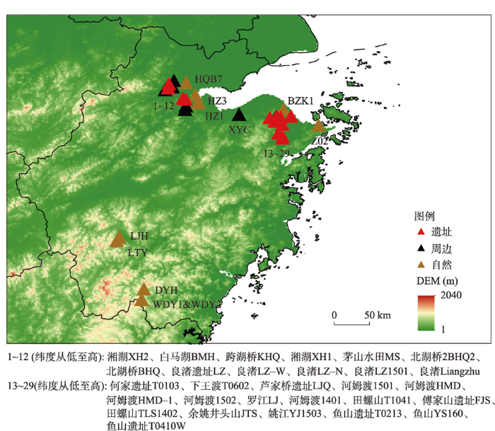
利用中国知网(CNKI)、Web of Science和Google Scholar等学术引擎,以“浙江”“上山文化”“跨湖桥文化”“河姆渡文化”“马家浜文化”“良渚文化”“马桥文化”“孢粉”“钻孔”等中英文关键词进行组合搜索,检索发表时间为2006—2021年文献,获得钻孔记录共63条。剔除非孢粉记录4条,无效测年记录8条,孢粉类群少于10种或孢粉图谱无法辨认的记录9条,时间跨度小于0.5 ka的记录1条,海相钻孔1条,最终保留有效孢粉记录共40条(图1、附表)。其中11条为原始孢粉记录,包括已发表数据和经联系原作者获得的数据,其余记录则利用STRADITIZE软件[16]对孢粉图谱进行数值化,并对数值化的孢粉数据进行确认检查。
图1
依据已发表的中国现代花粉数据集[17],对40条记录中的孢粉类群名称进行标准化(其中伞形科Umbelliferae更正为Apiaceae,菊科Compositae更正为Asteraceae,十字花科Cruciferae更正为Brassicaceae,豆科Leguminosae更正为Fabaceae,禾本科Gramineae更正为Poaceae)。对于组合孢粉类群,则按照孢粉首字母顺序进行统一,例如,云杉属和冷杉属Picea+Abies统一为Abies+Picea。因钻孔中的禾本科包括大禾(粒径大于35 µm)和小禾(粒径小于35 µm),在此,本文对同一钻孔内的禾本科花粉进行了加和处理。
在原始孢粉记录中,孢粉的百分比含量系以不同标准计算,为进行不同钻孔间的对比,本文采用统一的计算规则对孢粉百分比进行重计算。陆生植物花粉的百分比含量以陆生植物花粉的总数作为基数,水生植物花粉和蕨类植物孢子的百分比含量则以孢粉总数作为分母计算。其中,莎草科(Cyperaceae)和毛茛科(Ranunculaceae)作为水生/湿生植物,不加入陆生植物花粉百分比的计算。由于多数孢粉记录为数值化数据,若原始文献中孢粉百分比含量计算规则与本文一致,则使用原文中数值化数据。最终,对不符合标准的24条孢粉记录进行百分比含量的重新计算。
利用R软件的rbacon 2.5.8程序[18]对40条孢粉记录重新进行了年代模型的构建。本文尊重了原始文献对钻孔/剖面的岩芯判断、对测年数据的选择以及对沉积间断的描述,并为没有人为扰动的泥炭、湖泊钻孔顶部添加了采样年份作为年代控制点。傅家山遗址钻孔FJS、鱼山遗址YST0410W和YS160、芦家桥遗址钻孔LJQ的原始记录中明确指出了沉积间断的存在,对应的风暴沉积层位在构建年代模型中予以剔除。对测年材料为贝壳或海相地层的年代使用Marine20进行校准,其他14C测年则使用IntCal20进行校准,OSL测年和人为添加的年代控制点则不进行校准。在年代模型重构的过程中,对碳库年代以及沉积间断进行了处理。使用Bacon输出了1000次年代插值结果作为植被变化速率(Rate-of-Change, RoC)计算的年代误差,并采用样品深度的平均年代进行后续计算和讨论。
按照有无史前文化的发生,将40条孢粉记录分为遗址、周边和自然3种数据类型。遗址孢粉记录为原始文献中有明确提及史前人类活动的证据,如史前文物等,一般在考古遗址内取样获得的孢粉数据。新石器先民活动的范围,在前人研究中并没有得到统一,但普遍认为史前人类活动已经影响了遗址周围3 km范围内的植被变化[19-20],故周边孢粉记录定义为,在钻孔中并没有人类活动的直接证据,地理位置距离考古遗址点3 km以内,且孢粉的变化能够体现一定的人类干扰,如稻属禾本科、栎属(Quercus)、松属和炭屑等含量的异常波动。自然孢粉记录则定义为,在钻孔中没有人类活动的证据,地理位置距离考古遗址点3 km以上,且孢粉组合的变化在新石器时期不能反映人类活动的存在。判断的标准是,伴人花粉无明显增多、总乔木花粉含量波动变化幅度较小、次生干扰物种如松属、芒萁属(Dicranopteris)等没有持续增加等。
2.2 植被变化速率计算
运用R软件的RRatepol包[21]计算了各个孢粉记录的植被变化速率。植被变化速率是单位时间内植被成分的差异,反映了植被自然演替以及外界干扰的响应过程,包括自然气候环境变化以及人类活动的干扰等引起的变化。地层花粉数据能够反映植被的变化过程[22],但是其蕴含的变化速率却受到沉积速率以及样品分辨率的直接影响。在此,本文采用了RRatepol内置的“Moving window”即滑动时间窗口法,将单位时间的长度统一,以时间加权平均对数据进行了滑动平均,同样将样品的年代不确定性输入模型计算,以最大限度地减少因样品密度和沉积速率变化等造成的误差,从而获得真实无偏的RoC值。在计算过程中,采用了400 a作为时间窗口,计算各区间的“Bray-Curtis”距离,并进行随机的10000次运算得到每个样点的RoC变化区间和均值。对所有钻孔采用同样的参数进行运算,以满足不同钻孔结果的对比。最终得出的RoCs,按照遗址、周边和自然3类分别进行系统集成平均,获得遗址点、周边点和自然点的RoC值。
2.3 生物群区化
Biomisation是一种利用花粉数据定量重建生物群区的一种标准化方法,特点是能够快速且直观的呈现不同时空尺度上古植被分布格局的变化[23]。本文采用倪健等[24]建议的中国生物群区方案,选取陆生植物花粉输入Biomisation,以0.5%作为阈值,不对花粉类群加权处理。计算结果中包括10种生物群区类型。分别为温带落叶阔叶林(Temperate deciduous broad-leaved forest, TEDF)、寒温带针阔混交林(Cool-temperate needle-leaved and broad-leaved mixed forest, CLMF)、寒温带常绿森林(Cold-temperate evergreen forest, CTEF)、暖温带(亚热带)常绿阔叶林(Warm-temperate evergreen broad-leaved forest, WTEF)、高山灌丛(Alpine Shrubland, APSH)、温带草原(Temperate grassland, TEGR)、温带荒漠(Temperate desert, TEDE)、高山荒漠(Alpine desert, APDE)、高山草原(Alpine grassland, APGR)、高山苔原(Alpine tundra, APTU)。因采用中国生物群区方案,并且研究区涉及到人类活动强烈干扰的植被过程,导致Biomisation结果中部分生物群区可能并不适用于浙江地区全新世植被变化。对此,采用结合孢粉数据进行专家判断的方法,人工选择最具有代表性的地区性生物群区。同时为更清晰地展现各生物群区的宏观变化特征,将相同生物气候带的生物群区归并至6大类:温带落叶阔叶林归并至温带森林(Temperate forest, TF)、寒温带针阔混交林和寒温带常绿森林归并至寒温带森林(Cold-temperate forest, CTF)、暖温带(亚热带)常绿阔叶林归并至暖温带(亚热带)森林(Warm-temperate forest, WTF)、高山灌丛归并至灌丛(Shrubland, SH)、温带草原和温带荒漠归并至偏温性草地(Warmer grassland, WG)、高山荒漠、高山草原和高山苔原归并至偏冷性草地(Cooler grassland, CG)。
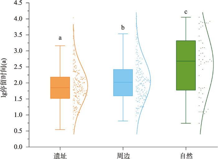
为探讨植被本身的稳定性和弹性,本文统计了各记录在全新世期间的生物群区转变次数和停留时间。生物群区的转变次数定义为在同一记录中某一时间段内不同生物群区发生转变的次数,若未发生转变,则记该生物群区转向其本身一次;停留时间指生物群区在某一时间段中保持相同状态的时间[25]。但由于生物群区的转变发生在一个时间区间内,无法确定转变发生的准确时间,而时间区间的中点可看作是生物群区转变时间的平均估算,故本文使用发生生物群区转变的相邻样本之间的区间中点来计算生物群区在每个花粉记录内的停留时间。转变次数以弦图展示,停留时间与显著性检验结果以箱型图展示,并使用R软件对遗址、周边和自然的停留时间进行显著性检验。
3 结果
3.1 样点信息统计
孢粉记录中共包含19个遗址类记录、11个周边类记录和10个自然类记录,来自于10个遗址点或者遗址剖面、17个陆地或三角洲钻孔、8个湖相或河流相钻孔、5个泥炭剖面。原始文献发表时间均为2006—2021年,其中2015年及之后发表的研究有20条,占比为50%。遗址记录中有2条记录记载了跨湖桥文化,有12条记录记载了河姆渡文化,9条记录了良渚文化,其中部分遗址连续发生了数个文化的更替,如鱼山遗址T0213、何家遗址T0103、下王渡T0602等。绝大多数孢粉记录点分布的海拔高度低于25 m,仅有5条自然记录点的海拔高于900 m。海侵对浙江全新世植被的影响不可忽视,有21条孢粉记录描述了海侵事件的发生,其中有13条为遗址类别。
在40条记录中共收集有效测年数据237个,含225个AMS 14C年代以及12个OSL测年,平均每个记录的测年数量为6个。构建的年龄—深度模型中,最长的时间跨度贯穿整个全新世,最短的则跨越了0.8 ka。遗址点记录的年代跨度范围为16.0—1.0 cal ka BP,平均年代跨度为3.5 ka;遗址周边记录的年代跨度范围为0.4—15.0 cal ka BP,平均年代跨度为6.0 ka;自然样点记录的年代跨度范围为30.0—0 cal ka BP,平均年代跨度为13 ka。
在所收集的孢粉研究记录中,共鉴定样品2692件,平均每个记录点为67件。其中,12.0—9.0 cal ka BP统计了190件孢粉样品,9.0—6.0 cal ka BP统计了879件孢粉样品,6.0—4.0 cal ka BP统计了884件样品,4.0—2.0 cal ka BP统计了294件孢粉样品,2.0—0 cal ka BP统计了197件孢粉样品,共记录孢粉类群206个,分属于103科和147属。总体上,浙江全新世孢粉组成以乔木类群松属、栎属、桦木属(Betula)、榆属(Ulmus)、鹅耳枥属(Carpinus)、桤木属、锥属(Castanopsis)、铁杉属(Tsuga)、栗属(Castanea)、枫香树属(Liquidambar)和青冈属(Cyclobalanopsis),草本植物禾本科、蒿属(Artemisia)、藜科(Chenopodiaceae)、菊科、唇形科(Lamiaceae)和十字花科等为主,蕨类植物以水龙骨科(Polypodiaceae)为主。在全新世初期,各点记录的孢粉变化较为一致,草本植物和针叶乔木的花粉浓度逐渐降低,而喜暖的阔叶植物花粉含量上升。进入全新世中期后,遗址点与自然点的孢粉组合明显分化,自然地区的乔木花粉占比明显上升,其中常绿栎属和水青冈属等含量增加的趋势最为明显,而遗址地区的草本植物占比远大于自然地区,其中最为突出的变化特征是在6.0 cal ka BP之后,禾本科花粉的含量普遍增加。3.0 cal ka BP后,自然点的孢粉组合中也出现了较多的禾本科花粉,且含量不断增加,乔木花粉的含量则迅速减少。
3.2 植被变化速率
遗址、周边和自然点的RoC值见图2。遗址点的RoC波动最为剧烈,均值为0.0361,集成平均后的变化区间为0.0045~0.062。其变化表现出明显的阶段性,分别为12.0—9.0 cal ka BP各孢粉记录的RoC波动平缓;9.0—5.8 cal ka BP期间RoC逐渐上升,其中TLS1402钻孔的RoC值在7.8 cal ka BP达到峰值,傅家山遗址剖面、HMD1501钻孔、HMD1502钻孔、HMD钻孔、田螺山T1041剖面和芦家桥钻孔等的ROC皆在6.0 cal ka BP左右达到峰值;5.8—5.3 cal ka BP期间RoC波动降低,多数孢粉记录的RoC都在此时间段呈现出下降趋势;5.3—4.0 cal ka BP期间RoC快速回升,田螺山T1041剖面、YS160钻孔、茅山水田钻孔、LZN剖面和LZW剖面等的RoC都位于高值区间;4.0—1.4 cal ka BP期间RoC继续下降至最低值,并且该阶段的孢粉记录数量较少。
图2
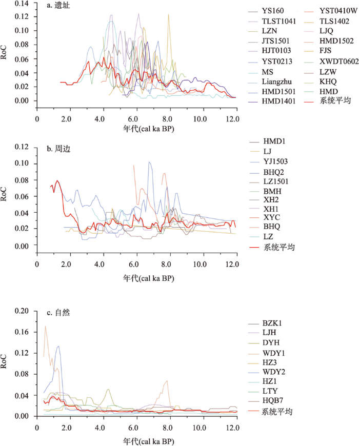
图2
遗址、周边和自然点的植被变化速率
Fig. 2
Vegetation change rates of the archaeological, peripheral and natural sites
周边点的RoC较遗址点平缓,均值为0.0297,集成平均后变化区间介于0.015~0.079之间。在12.0—9.0 cal ka BP期间RoC总体较为平稳;在9.0—7.8 cal ka BP期间RoC波动增加,其中北湖桥钻孔、姚江1503钻孔和白马湖钻孔的RoC增加趋势较为明显;在7.8—3.0 cal ka BP期间RoC表现出明显的阶段型变化特征,如5.5—6.3 cal ka BP高值区和4.3—3.0 cal ka BP波动降低,以及7.8 cal ka BP和5.5 cal ka BP前后的迅速降低,均较为明显;3.0 cal ka BP后RoC降低趋势得到扭转,随后开始迅速增加,RoC值超过了遗址点并于1.0 cal ka BP左右达到峰值。
自然点的RoC变化最为稳定,平均值为0.0159,变化区间为0.0059~0.027。总体而言,自然点的RoC在3.0 cal ka BP前非常稳定,但从2.5 cal ka BP起,RoC开始表现出明显的增加趋势。
3.3 古植被格局变化
12 cal ka BP至今共重建生物群区2444个,其中暖温带森林出现1348次、温带森林789次、寒温带森林30次、灌丛83次、偏冷性草地167次、偏温性草地27次。自然点在全新世早期发育温带森林与草地镶嵌分布的景观,至中全新世温带森林逐渐转变为常绿阔叶森林,至晚全新世常绿成分下降,并且在3.0 cal ka BP以后,灌木丛和草地群落频繁出现与切换。遗址及周边点的植被变化较复杂,在全新世中期草地群落就已经开始出现,且随后草地群落出现的频次愈来愈多。
统计40条孢粉记录各个生物群区发生转变的次数发现:由暖温带森林转变为其他生物群区157次,未发生转变7次;由温带森林转变为其他生物群区136次,未发生转变4次;由寒温带森林转变为其他生物群区3次;由灌丛转变为其他生物群区31次;由偏冷性草地转变为其他生物群区81次;由偏温性草地转变为其他生物群区23次。而由其他生物群区转变为暖温带森林155次,转变为温带森林130次,转变为寒温带森林2次,转变为灌丛31次,转变为偏冷性草地90次,转变为偏温性草地22次。
遗址、周边和自然点生物群区的转变次数(图3)表明,遗址点的生物群区转变明显复杂于周边点和自然点,最为突出的特征是草地景观的转变次数占比大。自然点的孢粉记录平均年代跨度较长,记录了全新世初期的寒温带森林群落的转变,且群落之间的相互转变次数较为均匀。周边点生物群区的转变特征是暖温带森林与温带森林之间的相互转变占了绝大部分,但草地群落和灌丛群落也频繁发生变更。
图3
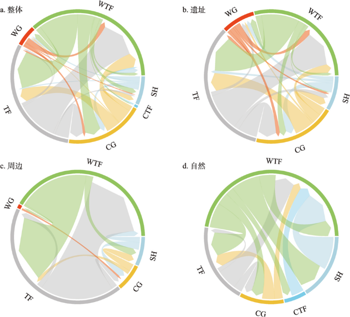
图3
浙江全新世生物群区转变
注:CTF为寒温带森林,TF为温带森林,WTF为暖温带森林,SH为灌木丛,CG为偏冷性草地,WG为偏温性草地;不同的颜色表示了不同的生物群区;箭头代表了转变的方向,箭身粗细则代表了所示转变方向上发生的相对频次。
Fig. 3
Holocene biome shifts in Zhejiang
遗址、周边和自然孢粉记录的生物群区停留时间存在显著性差异(图4)。遗址、周边和自然点的生物群区停留时间中位数分别为71 a、104.5 a和481.5 a,遗址和周边的生物群区停留时间相较自然点呈现碎片化,其数量更多,时间更短。
图4
4 讨论
本文依据孢粉分析记录的位置,将研究点分为4类,分别是不受人类活动影响的自然点和受到直接或间接人类活动影响的遗址及周边点。自然点的植被变化在早—中全新世总体较为稳定。在全新世初期,气候由寒冷干燥变得温凉湿润[26],各点记录的陆生草本和湿生草本的花粉浓度皆有所下降,而乔灌木花粉含量上升,森林植被逐渐恢复,同时在部分山地发育的寒温带森林群落逐渐向着温带和暖温带森林转变(图5a)。在9.0—2.0 cal ka BP期间,自然点的植被演替主要为森林群落间的相互转变,暖温带森林群落处于优势地位;2.0 cal ka BP以后,自然点的生物群区多样性增加,且变化格局更为复杂,灌丛和偏冷型草地植被占了较大比例。进一步细分自然点的植被变化,可依据地理位置分为高海拔山区和平原地区。
图5
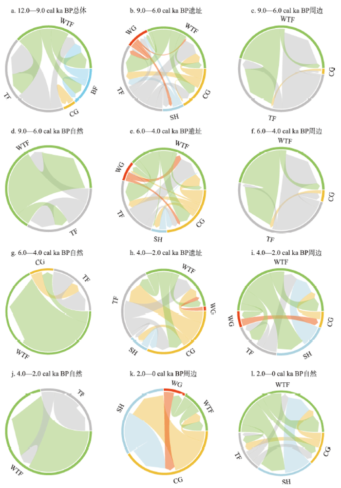
图5
遗址、周边和自然点不同时间段的生物群区转变
注:CTF为寒温带森林,TF为温带森林,WTF为暖温带森林,SH为灌木丛,CG为偏冷性草地,WG为偏温性草地。
Fig. 5
Biome shifts at different periods in archaeological, peripheral and natural sites
高海拔地区的植被变化可分为4个阶段:9.0—5.0 cal ka BP,气候温暖湿润,高海拔山区发育了以常绿栎、锥属和栗属为优势的亚热带常绿阔叶林,其中含有少量温带森林成分;5.0—3.0 cal ka BP,山区开始发育沼泽环境[27],水生植物如莎草科等快速生长,常绿栎和锥属等乔木含量下降,但整体的植被景观仍是含温带落叶成分的常绿落叶阔叶混交林;2.0—1.0 cal ka BP,常绿阔叶林的覆盖率开始大幅下降,松属花粉含量明显增加,同时耐旱的陆生草本含量上升,景观开放程度增加,指示了人类活动的存在[28];1.0 cal ka BP至今,乔木植物占比进一步下降,具栽培指示意义的禾本科含量上升[29],表明种植业的影响已经在高海拔地区存在。平原地区的植被变化阶段大致对应了全新世的不同时期:在早全新世,由于气候变化及海面波动的影响,浙江的平原区发育了以针叶林为主的针阔混交林[30],景观开放程度较高;在中全新世随着降水和温度的进一步增加,同时海水侵入了浙江腹地,尚未被海水淹没的地区发育了以常绿阔叶林为主的植被类型,乔木的含量占绝对的优势,景观开放程度低。到了晚全新世,平原地区的植被变化与高海拔山区类似,常绿乔木成分大幅下降,而次生树种和伴人植物种的含量上升[31]。
与自然地区植被变化不同的是,遗址和周边地区的植被变化不仅响应自然条件的改变,还受人类活动的影响。人类活动导致的植被变化主要表现为,原生森林植被的破坏以及与人类活动密切相关的经济作物属种、谷物类植物花粉的增加[19],和伴人杂草类植物花粉的增加等。遗址点的植被转变模式在9.0—3.0 cal ka BP期间最为丰富,在早期新石器人类活动的干扰下[32],遗址区全新世早期发育的以松林、栎属等为主的森林植被逐渐减少,次生灌木和草地植被增加,景观开放程度增加(图5b、5e)。3.0 cal ka BP以后,遗址植被变化相对简单,而周边点的植被变化突然丰富(图5i、5k),景观开放程度达到了全新世以来的最高值。
4.1 浙江新石器时期人类活动对遗址及周边植被的改造与利用
浙江地区是中国稻作文明的起源之一,在全新世早期,上山遗址已经发现了稻作农业存在的直接证据[33],意味着人类早在一万年前就已经开始告别穴居生活,拓展生活区域,同时对自然植被的影响强度也开始增加[9,34]。上山遗址探方的孢粉分析显示,上山文化晚期存在禾本科(< 38 µm)增加以及乔灌木花粉减少的现象[35],可能指示了人类活动对植被的影响。虽然现已经发现并挖掘了23个上山文化的考古遗址点,但主要集中在金衢盆地以及曹娥江上游,大多数考古点中并没有发表可用的孢粉序列,故无法评估该时期人类活动对自然植被的影响。从植硅体的相关研究,可推测上山文化稻作农业的发展和扩散集中于浙中地区[34,36]。近期有研究显示,杭嘉湖平原腹地万年前就已存在古人类活动迹象,可能指示了河谷地区稻作农业的发展[37]。但总体而言,在全新世早期,社会生产水平较弱,稻作农业尚在萌芽阶段,史前人类在此阶段对森林的破坏程度较低。
至跨湖桥文化(8.2—7.5 cal ka BP),稻作农业进一步发展、扩散,自然植被受到的干扰程度较上山文化阶段更强。对跨湖桥文化的研究表明[38],狩猎采集是跨湖桥文化的主要经济模式,先民砍伐周围的森林植被,移植和栽种低矮的灌木来获取浆果作为食物。湘湖钻孔显示,松属、栎属、锥属、枫香等亚热带常见木本植物花粉在此阶段较为丰富,草本植物以香蒲属和禾本科为主[39];湘湖2钻孔和白马湖钻孔则显示,地带性植被为亚热带针叶落叶阔叶混交林为主,遗址周围广布湿地、沼泽[20]。关于稻作农业模式,早期研究[13]认为跨湖桥时期存在刀耕火种的稻作农业模式,7.85—7.4 cal ka BP间,指示人类活动的禾本科以及碳屑在白马湖、湘湖2钻孔达到峰值,主要乔木植物中松属与栎属含量大幅降低。在本文结果中,遗址以及周边点的孢粉ROC变化幅度在此阶段迅速增加(图2),说明人类活动对植被的干扰进一步加剧。同时,重建的生物群区化结果则显示,森林群落与灌丛群落的相互转变较为频繁(图5b),也符合前人的研究结果[40]。
河姆渡至良渚文化时期的施岙古稻田、良渚古城等一系列重大考古发现表明,稻作农业已成为新石器时代先民主要的生业模式,良渚时期的社会发展水平已进入古国文明时期,对土地利用的需求大幅提升,同时人类活动对自然植被的影响也是空前的[41]。对河姆渡文化的研究认为[19],先民在6.0 cal ka BP前以狩猎采集为生,对原生植被的影响有限,但在6.0 cal ka BP之后,稻作农业成为河姆渡先民的主要经济模式,人类活动对植被的干扰程度日益增加。在此背景下,人类活动对周边的自然环境的改造,导致遗址孢粉记录中木本植物花粉含量逐渐降低,以常绿栎为代表的亚热带常绿阔叶林面积进一步缩减,而禾本科花粉以及伴生杂草类花粉含量增加,指示了农田以及草地面积逐渐上升。
在生物群区重建结果中,APDE(已归并至CG)是除森林群落外出现最多的生物群区类型,其多出现在遗址点孢粉记录中,与高百分含量的禾本科、蒿属、黎科植物花粉相对应。据现代花粉研究,< 35 µm的禾本科花粉主要来源是伴人杂草类植物,而> 35 µm则被认为是栽培类物种,即稻的花粉。藜科异常升高在沿海地区可看作是海侵事件的标志[42],蒿属则多生长在草原、荒漠地区[43]。本文选取6条花粉记录,将APDE在花粉记录中的百分比与禾本科、藜科和蒿属进行比较(图6)。结果表明APDE的得分百分比趋势与禾本科花粉含量变化有较大的一致性,在部分阶段受藜科花粉的影响,但与蒿属的含量并没有直接联系。由此说明,APDE得分主要受禾本科花粉含量的控制,即遗址和周边的自然景观在全新世中后期由封闭的森林群落转向开放的草地,主要是人类发展水稻农业所致。此阶段,农田开垦导致的森林植被向草地植被的转变是直接而快速的,这与本文结果中RoC变化以及生物群区转变结果一致(图2、图3)。遗址点的植被景观逐渐从封闭森林转变成了开放的草地,即使在史前人类文明阶段性的衰退期,遗址地区的景观也没有完全恢复至森林群落,说明局地植被变化趋势由于人类稻作农业行为而被永久改变。
图6
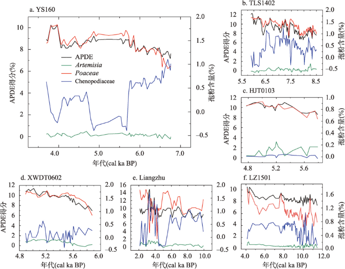
图6
APDE得分百分比与禾本科、藜科和蒿属含量的比较
注:APDE得分=(APDE分数/生物群区总分)×100%;孢粉含量的数据尺度进行了lg转换;Liangzhu和LZ1501为周边点,其余为遗址点。
Fig. 6
Comparison of APDE with contents of Poaceae, Chenopodiaceae and Artemisia
良渚文明之后,浙江地区的新石器文化逐渐由钱山漾文化—广富林文化—马桥文化的完整文化谱系,过渡到夏商时期的青铜文化早期[44]。浙江地区的青铜时代,一般认为是中原夏、商、周奴隶王朝(约公元前21世纪起)至越过兴灭阶段[45]。钱山漾和广富林文化遗存主要为陶器为主,而马桥文化则已兼具新石器时代特征和青铜时代特征[46]。青铜时代的到来,标志着社会生产力进一步发展,同时对自然植被的影响程度也进一步加强。以杭州市茅山遗址为例[47],4.0—3.0 cal ka BP期间,松属花粉快速增加,同时常绿栎属花粉则迅速减少,落叶乔木组分增加,蒿属、黎科植物花粉增加;对田螺山遗址区的TLS1402钻孔进行的孢粉分析,木本植物花粉含量迅速降低,中生草本花粉含量增加,其中以松属花粉和禾本科(大禾)增加趋势最为明显[48]。可见,良渚文化之后,人类活动对自然植被的影响并未随之减弱,这也与本文结果相一致,即4.0—3.0 cal ka BP期间遗址RoC依然保持在高值区甚至达到全新世最大值(图2a)。3.0 cal ka BP以来,随着社会生产力进一步发展以及人口的增加,人类活动的空间范围进一步扩大,对遗址周边植被的影响加剧。至越国晚期,浙江地区的人口、种植业均已发展到一定规模,可以支持越国开展数万人的军事行动,而此时人类活动对植被的影响也开始由河谷地带向山地扩散。此时的人类活动包括毁林开荒从而满足人口增加带来的粮食压力、对森林的管理以获取足够的生产资料等[49],均会导致原生森林植被的破坏,是浙江生物群区在晚全新世由森林向灌丛、草地转变的主要原因(图5k、5l)。
4.2 人类活动加速了浙江全新世区域植被的变化
宏观来讲,植被成分、结构和功能受到气候配置的制约和影响,植被与气候间处于动态平衡关系[50]。演变是植被随时间变化的动态特征,干扰是引起植被演变的主要驱动力,包含了自然和人为因子[51-52]。全新世期间浙江植被变化的自然干扰应该是长期气候变化趋势、气候事件以及海面波动。末次冰消期至全新世转变阶段,地球气候经历了剧变,引起了植被的快速变化[2],全新世气候环境条件总体趋于稳定,个别气候事件如8.2 ka冷事件、4.2 ka事件的季风变率增加等,均可能对植被变化造成了一定的影响[28]。浙江地区人类活动强度同样存在长期趋势和短期波动,表现为新石器文化的连续发展以及古文明的消亡、更替。长期的新石器时代人类的活动导致了植被景观的破碎化,甚至破坏了植物群落的正常演替趋势(见讨论4.1),原始的封闭森林向着开放的植被转变[53]。但是在不同的文化阶段,社会生产力水平不同,先民对土地利用的强度和模式也不同,这与自然干扰因素一起主导了区域植被的差异变化。
气候事件下的史前人类响应与植被变化模式一直是环境考古学研究的热点[54]。自然点RoC的变化趋势表明:自然区域的植被对短时气候事件的响应较弱,仅有HZ3钻孔和大仰湖钻孔可能强烈响应了8.2 ka事件和4.2 ka事件(图2c)。说明在浙江地区,短时间的气候事件并不能直接改变整个区域的植被格局,植被生态系统趋向于保持相对稳定的状态。然而,与自然地区表现不同的是,遗址点的RoC多次响应了全新世气候事件和海侵事件(图2a)。如遗址RoC在8.0—7.5 cal ka BP呈现先下降后上升的趋势,这与跨湖桥晚期的海侵事件[13,40]相对应。海面上升淹没了跨湖桥先民的生活用地,迫使人类向别处迁移,人类活动对植被的干扰减弱,RoC下降,但同时海侵事件改变了植被生存的自然背景,遭受人类干扰的次生植被又重新向着新的顶极群落演替,RoC上升。同样的响应也发生在了6.2 ka事件和4.2 ka事件时期(图2a和图7b、7c),这佐证了全新世千年气候振荡事件和海侵事件对杭嘉湖平原的影响。总体来讲,自然条件的长期变化,如全新世增温/降温趋势[55]、ENSO发生频率、北纬30°N夏季太阳辐射量、大气CO2浓度变化等,可能对短期的RoC波动变化贡献较弱(图7)。
图7
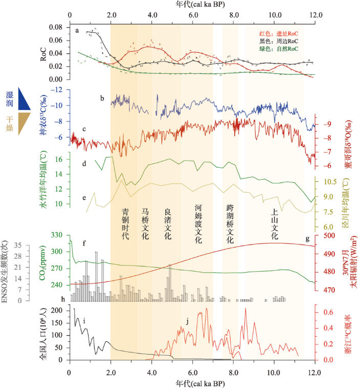
与自然点相比,遗址点RoC在全新世阶段发生了两次明显的趋势背离(图7a)。在9.0 cal ka BP左右,遗址点的RoC开始逐渐上升,而自然地区的植被变化稳定,这应该是浙江新石器时代先民对区域植被干扰产生的最早信号,14C的概率分布在此阶段也明显增高(图7j)。该背离模式一直持续到3 cal ka BP左右,且期间遗址点的RoC高于自然点2~3倍(图7a),这可能代表了新石器时代先民对植被的高强度干扰,人类活动在古人生活的范围内正在或者已经成为影响自然植被变化最为重要的因素。同样的,周边点处于低海拔地区,可能受到环境变化的直接影响以及人类活动的间接干扰。虽然,周边点的RoC值不及遗址点,但也表现出一定的波动变化(图7a),说明在新石器文化繁荣期人类活动同样对低海拔遗址周边地区产生了一定影响。此外,新石器先民多依水而居[64],遗址点孢粉记录在某些时段反映的可能是河流上游的区域植被变化,RoC结果可能仍然低估了全新世人类活动对局部植被的干扰程度。
第二次背离出现在3.0 cal ka BP左右,表现为周边点和自然点的RoC迅速增加,而遗址点下降。此时期,文化遗址由于各式各样的问题被废弃(图7j),先民向周边和自然地区迁徙,浙西南山区的植被变化加速可能是好川文化等对山地区域的深入开发,说明此时人类活动对区域植被的影响强度和范围均达到全新世最大值。随着古越国建立以及后续秦王朝的统一,社会发展进入了新时期,社会生产力进步、人口迅速增加(图7i、7j),人地矛盾进一步加剧。在此背景下,人类活动对自然植被的影响开始由遗址点向周边迅速扩散,山地偏远地区自然植被也受到了明显干扰,表现为自然点2.0 cal ka BP至今的孢粉记录中普遍存在的人类活动指示种,且RoC明显大于全新世初期。从全新世整体来看,人类活动加速了区域植被变化。
4.3 浙江全新世植被变化对现代植被保护的启示
有研究表明,仰韶文化自全新世中期以来人地关系演变的主导因素整体呈现由自然因素向人为因素偏移[65]。本文结果也显示了相似的变化趋势,浙江新石器时代人类活动导致的土地利用及其对自然植被的干扰在全新世期间逐渐增加,近几千年来人为因素在塑造区域植被景观的过程中日益重要,甚至可能超过了自然环境改变所带来的影响。在物种层面,一方面部分物种如栎属[19]和果树[66]等,更倾向得到保护甚至选择性培育[38];另一方面,由于人为毁林、农田管理为草本植物生长提供了空间;更重要的是,由于人类活动干扰,如火的使用、选择性砍伐等,可能导致物种竞争关系发生了变化,造成部分种属种群逐渐缩小,甚至达到濒危边缘,如百杉祖冷杉等。因此,长期来看,现代植物物种组成是长期人类活动干扰下的结果,保护和恢复某些植物类群,有必要将人类活动的干扰及影响历史纳入考虑范畴。
在生态系统层面,全新世人类活动加速区域植被变化的同时,也改变了植被生态系统的弹性。新石器时代先民对土地利用的模式可大体分为狩猎采集和种植水稻两类[15],且水平不一的强度导致不同阶段植被承受的压力不同。在此,本文将森林—灌丛—草地的转变称为间接转变,森林—草地的转变称为直接转变。生物群区转变的结果(图3a)表明直接转变发生的次数远大于间接转变,且随着文化的更替,直接转变的频率也明显增加(图5b、5e和5h)。此外,图4显示遗址点生物群区的停留时间显著短于周边和自然点,这说明全新世期间频繁的人类活动改变了局地植被的稳定性,人类活动的静止期短于群落自我恢复所需要的时间,生物群区重新转变至潜在植被面貌的能力减弱,甚至无法复原,对应着生态系统弹性的损失。值得指出的是,多样化的生物群区可能增加了生态系统的荷载能力,且复杂的农业景观往往拥有更高的生物多样性[67]。RoC的结果具体表明了在6.3—5.8 cal ka BP期间,遗址点的RoC最高(图7a),人类活动干扰最强,这是因为在河姆渡先民在稻作农业的初期阶段,为开拓农田而大规模砍伐森林、开垦田地,当稻作农业发展成熟后,稻田—森林景观的生态系统趋于稳定,且有人类的田间管理介入,该时期的生态系统形成新的稳态。但是,由于古人对自然灾害的影响抵御能力较弱,加上农田肥力降低后的生存压力增加,往往倾向于迁移获取新的宜耕土地,这也是导致遗址点生物群区稳定性和弹性降低的原因之一。
5 结论
利用40条孢粉记录量化植被的变化速率和定量重建古植被的时空分布格局,揭示了浙江地区全新世期间人类对植被干扰的过程,主要结论如下:
(1)浙江新石器时代的人类活动改变了区域的植被分布和变化趋势。毁林开荒和农业种植是先民重要的生活生产方式,在持续的人类活动干扰下,遗址点的生物群区多样性增加且变化复杂,封闭的森林群落逐渐向着开放草地转变。而从3.0 cal ka BP开始,自然点的植被也明显受到了人类活动的干扰,景观逐渐开放。
(2)遗址、周边和自然点的RoC在过去12 ka经历了两次明显的背离过程,第一次发生在9.0—3.0 cal ka BP,浙江在此期间经历了跨湖桥、河姆渡、良渚和马桥等多个文化,对应的遗址RoC总体呈现上升趋势,而自然RoC波动相对平缓,且遗址点的RoC值高于自然点2~3倍,说明浙江新石器人类活动加速了遗址局部的植被变化。此外,周边点的RoC值虽不及遗址点,但也表现出一定的波动变化,这说明新石器人类活动同样对低海拔的遗址周边地区产生了一定影响。第二次发生在3.0 cal ka BP,表现为周边和自然RoC增加以及遗址RoC的减少,说明了此时人类活动对区域的植被影响强度和范围均达到全新世最大值。从全新世整体来看,人类活动加速了区域植被变化是毋庸置疑的。
(3)浙江全新世期间,频繁的人类活动对植被造成干扰,从而改变了生态系统的稳定度和弹性,区域植被恢复至潜在面貌的能力减弱,甚至无法复原。但是史前人类活动的介入,增加了生物群区的多样性,可能导致了植物群落新稳态的出现。最后,本文建议在浙江地区以孢粉进行的气候重建,以及探讨自然保护地体系建设实践中面临的植被保护和恢复问题时,必须考虑长期的人类干扰历史以及植被变化历史格局的潜在影响。
附表 本文采用的孢粉样点信息
Appendix Table
| 属性 | 地点 | 经度(°) | 纬度(°) | 类型 | 14C测年数量 | 时间跨度 (cal ka BP) | 文化阶段 | 海侵 | 数据 来源 |
|---|---|---|---|---|---|---|---|---|---|
| 遗址 | 跨湖桥KHQ | 120.2 | 30.3 | 遗址探方 | 11 | 6.6—8.9 | 跨湖桥 | 是 | [1] |
| 遗址 | 傅家山遗址FJS | 121.4 | 30.0 | 陆地钻孔 | 6 | 3.9—8.6 | 河姆渡 | 是 | [2] |
| 遗址 | 鱼山遗址YS160 | 121.6 | 30.0 | 陆地钻孔 | 4 | 3.7—6.7 | 河姆渡、良渚 | 是 | [2] |
| 遗址 | 鱼山遗址YST0213 | 121.6 | 30.0 | 遗址探方 | 8 | 4.4—7.1 | 河姆渡、良渚 | 是 | [3] |
| 遗址 | 鱼山遗址YST0410W | 121.6 | 30.0 | 遗址探方 | 7 | 3.4—6.6 | 河姆渡 | 是 | [2] |
| 遗址 | 河姆渡HMD | 121.3 | 30.0 | 河流相钻孔 | 6 | 2.5—6.7 | 河姆渡 | - | [4] |
| 遗址 | 河姆渡HMD1401 | 121.4 | 30.0 | 陆地钻孔 | 19 | 3.2—14.6 | 河姆渡 | 是 | [5] |
| 遗址 | 河姆渡HMD1501 | 121.4 | 29.9 | 陆地钻孔 | 5 | 6.2—8.7 | 河姆渡 | 是 | [6] |
| 遗址 | 河姆渡HMD1502 | 121.4 | 30.0 | 陆地钻孔 | 4 | 5.9—10.0 | 河姆渡 | 是 | [6] |
| 遗址 | 田螺山TLS1402 | 121.4 | 30.0 | 陆地钻孔 | 6 | 5.8—8.5 | 河姆渡 | 是 | [7] |
| 遗址 | 田螺山TLST1041 | 121.3 | 30.0 | 遗址探方 | 10 | 3.6—7.1 | 河姆渡、良渚 | - | [8] |
| 遗址 | 良渚遗址Liangzhu | 120.0 | 30.4 | 遗址探方 | 2 | 2.1—9.9 | 良渚 | - | [9] |
| 遗址 | 何家遗址HJT0103 | 121.4 | 30.0 | 遗址探方 | 4 | 4.7—5.7 | 河姆渡、良渚 | - | [10] |
| 遗址 | 芦家桥遗址LJQ | 121.4 | 29.8 | 陆地钻孔 | 5 | 4.9—6.7 | 河姆渡 | 是 | [2] |
| 遗址 | 余姚井头山JTS1501 | 121.4 | 30.0 | 陆地钻孔 | 5 | 4.8—6.5 | 跨湖桥、河姆渡 | 是 | [11] |
| 遗址 | 下王渡XWDT0602 | 121.4 | 29.8 | 遗址探方 | 7 | 4.8—5.8 | 河姆渡、良渚 | 是 | [12] |
| 遗址 | 茅山水田MS | 120.2 | 30.3 | 遗址探方 | 3+4OSL | 1.0—16.0 | 良渚 | - | [13] |
| 遗址 | 良渚遗址LZ-N | 120.0 | 30.4 | 遗址探方 | 7 | 3.5—4.5 | 良渚 | - | [14] |
| 遗址 | 良渚遗址LZ-W | 120.0 | 30.4 | 遗址探方 | 2 | 4.1—4.9 | 良渚 | - | [14] |
| 周边 | 姚江YJ1503 | 121.4 | 30.0 | 陆地钻孔 | 10 | 1.2—12.0 | - | 是 | [15] |
| 周边 | 良渚LZ1501 | 120.0 | 30.4 | 陆地钻孔 | 4 | 4.1—11.0 | - | 是 | [16] |
| 周边 | 白马湖BMH | 120.2 | 30.2 | 湖相钻孔 | 8 | 6.7—9.0 | - | 是 | [17] |
| 周边 | 湘湖XH2 | 120.2 | 30.1 | 湖相钻孔 | 7 | 7.1—8.7 | - | 是 | [17] |
| 周边 | 河姆渡HMD1 | 121.4 | 30.0 | 河流相钻孔 | 11 | 1.8—15.0 | - | - | [18] |
| 周边 | 新一村XYC | 120.9 | 30.1 | 陆地钻孔 | 4 | 5.3—7.3 | - | 是 | [19] |
| 周边 | 北湖桥BHQ | 120.0 | 30.4 | 河流相钻孔 | 4 | 7.0—10.0 | - | - | [20] |
| 周边 | 北湖桥2BHQ2 | 120.0 | 30.4 | 陆地钻孔 | 6 | 0.4—6.0 | - | 是 | [19] |
| 周边 | 良渚LZ | 120.1 | 30.5 | 陆地钻孔 | 5 | 2.8—5.5 | - | - | [21] |
| 周边 | 罗江LJ | 121.4 | 30.0 | 三角洲钻孔 | 4 | 1.3—13.0 | - | - | [22] |
| 周边 | 湘湖XH1 | 120.2 | 30.3 | 陆地钻孔 | 6 | 3.0—11.0 | - | - | [23] |
| 自然 | 杭州HQB7 | 120.2 | 30.5 | 河流相钻孔 | 4 | 0.2—29.0 | - | 是 | [24] |
| 自然 | 宁波Z02 | 121.9 | 29.9 | 河流相钻孔 | 5 | 0.7—13.0 | - | 是 | [25] |
| 自然 | 烂浆湖钻孔LJH | 119.3 | 28.5 | 泥炭剖面 | 2 | 0—8.0 | - | - | [26] |
| 自然 | 烂田砚泥炭LTY | 119.3 | 28.4 | 泥炭剖面 | 5 | 0.1—8.0 | - | - | [27] |
| 自然 | 望东洋WDY2 | 119.6 | 27.7 | 泥炭剖面 | 4 | 0—7.4 | - | - | [26] |
| 自然 | BZK1 | 121.5 | 30.1 | 河流相钻孔 | 3 | 4.7—30.0 | - | 是 | [28] |
| 自然 | 大仰湖DYH | 119.7 | 27.8 | 泥炭剖面 | 5 | 0—5.4 | - | - | [29] |
| 自然 | 三盈村HZ1 | 120.4 | 30.2 | 陆地钻孔 | 4OSL | 0—15.0 | - | - | [30] |
| 自然 | 下沙镇HZ3 | 120.3 | 30.3 | 陆地钻孔 | 4OSL | 0—13.0 | - | - | [30] |
| 自然 | 望东洋WDY1 | 119.6 | 27.7 | 泥炭剖面 | 7 | 0—8.3 | - | - | [31] |
致谢
特别感谢马春梅、李春海、叶玮等提供部分孢粉数据,及审稿专家和编辑部老师建设性的修改意见。
数据来源:
[1] Zong Y Q, Chen Z Y, Innes J B, et al. Fire and flood management of coastal swamp enabled first rice paddy cultivation in east China. Nature, 2007, 449(7161): 459-462.
[2] Tang Liang. Middle Holocene seawater intrusion and human's rapid response in the Yaojiang-Ningbo coastal plain, East China [D]. Shanghai: East China Normal University, 2019.
[唐亮. 姚江—宁波平原中全新世海水入侵及古人类活动的快速响应[D]. 上海: 华东师范大学, 2019.]
[3] He K Y, Lu H Y, Zheng Y F, et al. Middle-Holocene sea-level fluctuations interrupted the developing Hemudu culture in the lower Yangtze River, China. Quaternary Science Reviews, 2018, 188: 90-103.
[4] Liu Y, Sun Q L, Fan D D, et al. Pollen evidence to interpret the history of rice farming at the Hemudu site on the Ningshao coast, eastern China. Quaternary International, 2016, 426: 195-203.
[5] Huang Zhenhui. A study on the relationship between Holocene environment and human activities in the Yaojiang plain, Zhejiang province: A palynological analysis based on HMD1401 core [D]. Nanjing: Nanjing University, 2019.
[黄振辉. 浙江姚江平原全新世环境与人类活动关系研究[D]. 南京: 南京大学, 2019.]
[6] Ouyang X H, Hao X D, Zheng L B, et al. Early to mid-Holocene vegetation history, regional climate variability and human activity of the Ningshao Coastal Plain, eastern China: New evidence from pollen, freshwater algae and dinoflagellate cysts. Quaternary International, 2019, 528: 88-99.
[7] Ma Chunmei, Wang Bingling, Liu Zeyu, et al. human activity of pollen records during middle-late Holocene in Tianluoshan site, Ningshao Plain. Quaternary Research, 2018, 38(5): 1304-1312.
[马春梅, 王冰翎, 刘泽雨, 等. 浙江田螺山遗址区孢粉学记录的中全新世植被、环境和人类活动初步研究. 第四纪研究, 2018, 38(5): 1304-1312.]
[8] Li C H, Zheng Y F, Yu S Y, et al. Understanding the ecological background of rice agriculture on the Ningshao plain during the Neolithic Age: Pollen evidence from a buried paddy field at the Tianluoshan cultural site. Quaternary Science Reviews, 2012, 35: 131-138.
[9] Li Y Y, Wu J, Hou S F, et al. Palaeoecological records of environmental change and cultural development from the Liangzhu and Qujialing archaeological sites in the middle and lower reaches of the Yangtze River. Quaternary International, 2010, 227(1): 29-37.
[10] Li H Y, Sun J E, Ma C M, et al. Paleoenvironmental evolution and human activities at the Hejia Site on the Ningshao coastal plain in eastern China. Frontiers in Earth Science, 2021, 8: 609912. DOI:10.3389/feart.2020.609912.
[11] Liu Zeyu. Pollen records of vegetation, climate changes and human activities duing the mid-late Holocene from JTS1501 in Ningshao Plain [D]. Nanjing: Nanjing University, 2018.
[刘泽雨. 宁绍平原中晚全新世植被、环境与人类活动耦合关系[D]. 南京: 南京大学, 2018.]
[12] He K Y, Lu H Y, Li Y N, et al. Cultural response to Middle Holocene sea‐level fluctuations in eastern China: A multi‐proxy approach. Boreas, 2020, 49(1): 71-88.
[13] Jin Y X, Mo D W, Li Y Y, et al. Ecology and hydrology of early rice farming: geoarchaeological and palaeo-ecological evidence from the Late Holocene paddy field site at Maoshan, the Lower Yangtze. Archaeological and Anthropological Sciences, 2019, 11(5): 1851-1863.
[14] Wang X C, Mo D W, Li C H, et al. Environmental changes and human activities at a fortified site of the Liangzhu culture in eastern China: Evidence from pollen and charcoal records. Quaternary International, 2017, 438: 189-197.
[15] Liu Y, Deng L J, He J, et al. Early to middle Holocene rice cultivation in response to coastal environmental transitions along the South Hangzhou bay of eastern China. Palaeogeography, Palaeoclimatology, Palaeoecology, 2020, 555: 109872. DOI:10.1016/j.palaeo.2020.109872.
[16] Ling Guangjiu. The landscape evolution and its influence on Liangzhu culture in the Liangzhu since the Last Glacial Maximum [D]. Nanjing: Nanjing Normal University, 2021.
[凌光久. 末次冰盛期以来良渚地区地貌演化及其对良渚文化的影响[D]. 南京: 南京师范大学, 2021.]
[17] Pan Haochen. Vegetation changes and human activities during the Neolithic period in the Kuahuquai area of Zhejiang: Comparison of pollen records between natural cores and archaeological profiles [D]. Hefei: University of Science and Technology of China, 2020.
[潘浩晨. 浙江跨湖桥地区新石器时代植被变化及人类活动[D]. 合肥: 中国科学技术大学, 2020.]
[18] Li Chunhai, Tang Lingyu, Wan Hewen, et al. Vegetation and human activity in Yuyao (Zhejiang province) inferred from the sporo-pollen record since the Late Holocene. Acta Micropalaeontologica Sinica, 2009, 26(1): 48-56.
[李春海, 唐领余, 万和文, 等. 晚更新世以来浙江余姚地区植被变化及人类活动. 微体古生物学报, 2009, 26(1): 48-56.]
[19] Zhang Yunxia. Environmental and vegetation history variabilities archived by pollen-spore of the drill core Beihuqiao2 in Hangjiahu Plain during the mid-late Holocene, China [D]. Jinhua: Zhejiang Normal University, 2017.
[章云霞. 杭嘉湖平原高分辨率孢粉记录的中—晚全新世环境变化[D]. 金华: 浙江师范大学, 2017.]
[20] Lu Wenchen, Ye Wei. Characteristics of pollen assemblage and climate change in the Holocene at Borehole BHQ in Pingyao area, Zhejiang province. Journal of Palaeogeography, 2014, 16(5): 687-701.
[陆文晨, 叶玮. 浙江瓶窑BHQ孔全新统孢粉组合特征与气候变化. 古地理学报, 2014, 16(5): 687-701.]
[21] Liu Yan, Li Maotian, Sun Qianli, et al. Palaeoclimatic and environmental changes since the Mid-Holocene in the Hangzhou bay and their possible impacts on the evolution of Liangzhu Culture. Journal of Lake Sciences, 2014, 26(2): 322-330.
[刘演, 李茂田, 孙千里, 等. 中全新世以来杭州湾古气候、环境变迁及对良渚文化的可能影响. 湖泊科学, 2014, 26(2): 322-330.]
[22] Atahan P, Itzstein-Davey F, Taylor D, et al. Holocene-aged sedimentary records of environmental changes and early agriculture in the lower Yangtze, China. Quaternary Science Reviews, 2008, 27(5-6): 556-570.
[23] Gu Mingguang, Chen Zhongda, Lu Chengzhong, et al. Holocene sporopollen records in the Xianghu area, Zhejiang and their palaeoclimatic significance. China Geology, 2006(5): 1144-1148.
[顾明光, 陈忠大, 卢成忠, 等. 浙江湘湖地区全新世孢粉记录及其古气候意义. 中国地质, 2006(5): 1144-1148.]
[24] Gu Mingguang. Late Quaternary sediments and paleoenvironmental evolution on the northern bank of the Qiantang River. Geology in China, 2009, 36(2): 378-386.
[顾明光. 钱塘江北岸晚第四纪沉积与古环境演变. 中国地质, 2009, 36(2): 378-386.]
[25] Zhang Peixin. Late Quaternary sporopollen assemblages and sedimentary environment in the coastal plain of southeast Ningbo [D]. Chengdu: Chengdu University of Technology, 2018.
[张培新. 宁波东南沿海平原晚第四纪孢粉组合与沉积环境分析[D]. 成都: 成都理工大学, 2018.]
[26] Wen Zhenming, Ye Wei, Ma Chunmei, et al. Middle-late Holocene vegetation history and climate change implied by pollens from Wangdongyang, southern Zhejiang Province, east China. Acta Micropalaeontologica Sinica, 2018, 35(3): 260-272.
[温振明, 叶玮, 马春梅, 等. 浙江南部望东垟孢粉记录的中晚全新世植被演化历史与气候变化. 微体古生物学报, 2018, 35(3): 260-272.]
[27] Ma T, Tarasov P E, Zheng Z, et al. Pollen- and charcoal-based evidence for climatic and human impact on vegetation in the northern edge of Wuyi Mountains, China, during the last 8200 years. The Holocene, 2016, 26(10): 1616-1626.
[28] Lin Qinglong, Lin Nan, Ma Hongjie. Late Quaternary sediments and paleoenvironmental evolution in Cixi, Hangzhou bay south coast area. Science Technology and Engineering, 2017, 17(9): 1-8.
[林清龙, 林楠, 马宏杰. 杭州湾南岸慈溪地区晚第四纪沉积与古环境演化. 科学技术与工程, 2017, 17(9): 1-8.]
[29] Wang H Y, Liao M N, Li K, et al. Liangzhu culture recessed earlier than expected under a variable climate in the mid-late Holocene. Palaeogeography, Palaeoclimatology, Palaeoecology. Under Review.
[30] Liu Jingwei, Zhao Shujun, Cheng Jie, et al. A study of vegetation and climate evolution since the Holocene near the banks of the Qiantang River in Hangzhou Bay. Earth Science Frontiers, 2007, 14(5): 235-245.
[刘静伟, 赵淑君, 程捷, 等. 杭州湾钱塘江两岸全新世以来的古植被及古气候研究. 地学前缘, 2007, 14(5): 235-245.]
[31] Zhao L, Ma C M, Wen Z M, et al. Vegetation dynamics and their response to Holocene climate change derived from multi-proxy records from Wangdongyang peat bog in southeast China. Vegetation History and Archaeobotany, 2021, 31(3): 247-260.
参考文献
Ecological consequences of human niche construction: Examining long-term anthropogenic shaping of global species distributions
DOI:10.1073/pnas.1525200113
PMID:27274046
[本文引用: 2]

The exhibition of increasingly intensive and complex niche construction behaviors through time is a key feature of human evolution, culminating in the advanced capacity for ecosystem engineering exhibited by Homo sapiens A crucial outcome of such behaviors has been the dramatic reshaping of the global biosphere, a transformation whose early origins are increasingly apparent from cumulative archaeological and paleoecological datasets. Such data suggest that, by the Late Pleistocene, humans had begun to engage in activities that have led to alterations in the distributions of a vast array of species across most, if not all, taxonomic groups. Changes to biodiversity have included extinctions, extirpations, and shifts in species composition, diversity, and community structure. We outline key examples of these changes, highlighting findings from the study of new datasets, like ancient DNA (aDNA), stable isotopes, and microfossils, as well as the application of new statistical and computational methods to datasets that have accumulated significantly in recent decades. We focus on four major phases that witnessed broad anthropogenic alterations to biodiversity-the Late Pleistocene global human expansion, the Neolithic spread of agriculture, the era of island colonization, and the emergence of early urbanized societies and commercial networks. Archaeological evidence documents millennia of anthropogenic transformations that have created novel ecosystems around the world. This record has implications for ecological and evolutionary research, conservation strategies, and the maintenance of ecosystem services, pointing to a significant need for broader cross-disciplinary engagement between archaeology and the biological and environmental sciences.
Past and future global transformation of terrestrial ecosystems under climate change
DOI:10.1126/science.aan5360
PMID:30166491
[本文引用: 2]
Impacts of global climate change on terrestrial ecosystems are imperfectly constrained by ecosystem models and direct observations. Pervasive ecosystem transformations occurred in response to warming and associated climatic changes during the last glacial-to-interglacial transition, which was comparable in magnitude to warming projected for the next century under high-emission scenarios. We reviewed 594 published paleoecological records to examine compositional and structural changes in terrestrial vegetation since the last glacial period and to project the magnitudes of ecosystem transformations under alternative future emission scenarios. Our results indicate that terrestrial ecosystems are highly sensitive to temperature change and suggest that, without major reductions in greenhouse gas emissions to the atmosphere, terrestrial ecosystems worldwide are at risk of major transformation, with accompanying disruption of ecosystem services and impacts on biodiversity.Copyright © 2018 The Authors, some rights reserved; exclusive licensee American Association for the Advancement of Science. No claim to original U.S. Government Works.
Putting people in the map: Anthropogenic biomes of the world
DOI:10.1890/070062 URL [本文引用: 1]
Anthropological contributions to historical ecology: 50 questions, infinite prospects
Pollen indicators of human activity
人类活动的孢粉指示体
A critical assessment of human-impact indices based on anthropogenic pollen indicators
Palynological evidence for the temporal stability of the plant community in the Yellow River Source Area over the last 7,400 years
DOI:10.1007/s00334-022-00870-5 [本文引用: 1]
Global acceleration in rates of vegetation change over the past 18,000 years
DOI:10.1126/science.abg1685
PMID:34016781
[本文引用: 2]
Global vegetation over the past 18,000 years has been transformed first by the climate changes that accompanied the last deglaciation and again by increasing human pressures; however, the magnitude and patterns of rates of vegetation change are poorly understood globally. Using a compilation of 1181 fossil pollen sequences and newly developed statistical methods, we detect a worldwide acceleration in the rates of vegetation compositional change beginning between 4.6 and 2.9 thousand years ago that is globally unprecedented over the past 18,000 years in both magnitude and extent. Late Holocene rates of change equal or exceed the deglacial rates for all continents, which suggests that the scale of human effects on terrestrial ecosystems exceeds even the climate-driven transformations of the last deglaciation. The acceleration of biodiversity change demonstrated in ecological datasets from the past century began millennia ago.Copyright © 2021 The Authors, some rights reserved; exclusive licensee American Association for the Advancement of Science. No claim to original U.S. Government Works.
New methods and advances in the study of the evolution of prehistoric agriculture in China
中国史前农业起源演化研究新方法与新进展
Towards quantification of Holocene anthropogenic land-cover change in temperate China: A review in the light of pollen-based REVEALS reconstructions of regional plant cover
Holocene coastal evolution preceded the expansion of paddy field rice farming
DOI:10.1073/pnas.1919217117
PMID:32929013
[本文引用: 1]
Rice agriculture is the foundation of Asian civilizations south of the Yangtze River. Although rice history is well documented for its lower Yangtze homeland area, the early southward expansion of paddy rice farming is poorly known. Our study investigates this process using a compilation of paleoenvironmental proxies from coastal sediment cores from southeast China to Thailand and Island Southeast Asia. We propose that a shortage of land suitable for paddy fields, caused by marine transgression, constrained rice agriculture during the mid-Holocene. Rapid expansion of coastal plains, particularly in deltaic basins, over the past three millennia has coincided with increases in land suitable for rice cultivation. Our study also helps explain the past population movements of rice farmers.Copyright © 2020 the Author(s). Published by PNAS.
Anthropogenic impacts on Late Holocene land-cover change and floristic biodiversity loss in tropical southeastern Asia
Fire and flood management of coastal swamp enabled first rice paddy cultivation in east China
DOI:10.1038/nature06135 [本文引用: 3]
Collapse of the Liangzhu and other Neolithic cultures in the lower Yangtze region in response to climate change
Floods and megadroughts affected the Neolithic cultures in the Yangtze River Delta between 4300 and 4000 years ago.
Response of prehistoric culture to climatic environmental changes since Holocene in Zhejiang, east China
DOI:10.11821/xb201207004
[本文引用: 2]
This paper conducts comparative studies on the distribution of prehistoric cultural sites of Zhejiang Province. The results show that Zhejiang prehistoric culture expanded gradually in this region before 4000 cal. a BP. The notable expansions occurred twice and at the same time the prehistoric culture was disseminated from west to east coast along the river valleys. After 4000 cal. a BP, prehistoric cultural sites-distributed region contracted obviously due to the termination of spreading trend to east coast, which was accompanied by two kinds of economic transitions of Zhejiang. The distribution of prehistoric cultural sites was closely related with sea level fluctuation in Holocene, especially on the banks of the Hangzhou Bay. The changes of prehistoric culture and the climatic environment are identical to each other. It is evidenced that the development, expansion and contraction of prehistoric culture are positively correlated to the climatic environmental change. The change of climatic environment is just the root cause for this change and transition of the economic formation. So the climatic environment is the dominant factor of the Zhejiang prehistoric culture vicissitudes, which has exerted great influence on distribution, dissemination, expansion and transmutation of the culture.
全新世以来浙江地区史前文化对环境变化的响应
STRADITIZE: An open-source program for digitizing pollen diagrams and other types of stratigraphic data
A modern pollen dataset of China
中国现代花粉数据集
DOI:10.17521/cjpe.2021.0024
[本文引用: 1]
孢粉是重建古植被、古气候的重要基础数据。孢粉数据库对研究样点至区域和全球尺度上的古环境演变规律、古气候变化特征反演和古生物地球化学循环模拟等具有重要意义。该文收集整理了中国1960-2020年间发表和部分未发表的现代花粉数据记录, 包括样品编号、采样位置、采样地经纬度和海拔高度、样品类型、数据来源、数据类型、周边植被信息、参考文献、花粉类群及其含量等信息; 并对数据进行筛选和标准化等处理, 由此整合为中国现代花粉数据集。该数据集由4 497个现代花粉采样点的数据信息组成, 包括660个来自中国第四纪孢粉数据库数据, 1 763个前期整理发表的数据和2 074个近期收集的数据, 涵盖772个花粉类群。样品类型以土壤表层样品(3 332个)为主, 苔藓样品以及湖泊、海洋表层样品等为辅, 广泛分布于全国不同地理区域和植被类型中, 其中以温带荒漠区域(24.91%)和亚热带常绿阔叶林区域(24.02%)最丰富, 其次为温带草原区域(16.14%)和青藏高原高寒植被区域(15.83%)。数据按照来源可分为原始数据(58%)和数值化数据(42%); 按照数据类型可分为原始统计粒数的样点(59%)和以花粉百分比表达的样点(41%)。半个多世纪以来, 科研人员开展了大量的表层现代花粉取样和研究。本数据集虽然仅获取部分记录, 但样点覆盖了我国绝大多数地区, 可有效地用于古植被与古气候重建的现代孢粉与现代植被校验, 并将为中国孢粉数据库的建立与更深入的孢粉研究提供数据支撑。
Flexible paleoclimate age-depth models using an autoregressive Gamma process
DOI:10.1214/ba/1339616472 URL [本文引用: 1]
Dynamic interaction between deforestation and rice cultivation during the Holocene in the Lower Yangtze River, China
Human activity has transformed the Earth’s landscapes pervasively for thousands of years, and the most important anthropogenic alteration was the clearing of forests and the establishment of agriculture. As a center of rice domestication and early population growth, the lower Yangtze River has been extensively transformed in the Holocene. However, the timing, extent, and process of deforestation and its relationship with the intensification of rice cultivation remain controversial. Here, four representative archaeological sites ranging from 8,100 to 4,300 cal a BP, that is, Jingtoushan, Hemudu, Yushan, and Xiawangdu sites, were selected for detailed palynological analysis, and evidence of anthropogenic deforestation and subsistence strategy were also synthesized to investigate dynamic human–forest interaction. Although natural vegetation had already been altered at the Jingtoushan site around 8,000 cal a BP, it was more likely to be the management of acorns by limiting burning to open habitats and increasing yield. As the subsistence shifted from acorn exploitation toward rice cultivation after 6,000 cal a BP, real deforestation for agriculture may occur at the Yushan and Xiawangdu sites due to conflict on labor input and land use. However, these deforestations were just confined to the archaeological sites at local scale, and no consistent vegetation change occurred at regional scales induced by human activities until the last 3,000 years.
Rate-of-change analysis in paleoecology revisited: A new approach
One hundred years of Quaternary pollen analysis 1916-2016
DOI:10.1007/s00334-017-0630-2 URL [本文引用: 1]
Biome distribution over the last 22,000 yr in China
DOI:10.1016/j.palaeo.2014.04.023 URL [本文引用: 1]
Plant biomes demonstrate that landscape resilience today is the lowest it has been since end-Pleistocene megafaunal extinctions
DOI:10.1111/gcb.v26.10 URL [本文引用: 1]
Quantitative Holocene climatic reconstructions for the lower Yangtze region of China
DOI:10.1007/s00382-017-3664-3 URL [本文引用: 1]
Development and climatic background of Dayanghu marsh peat from Jingning county, Zhejiang province
浙江景宁县大仰湖沼泽泥炭地形成过程及气候背景
Vegetation dynamics and their response to Holocene climate change derived from multi-proxy records from Wangdongyang peat bog in southeast China
DOI:10.1007/s00334-021-00852-z [本文引用: 2]
Pollen- and charcoal-based evidence for climatic and human impact on vegetation in the northern edge of Wuyi Mountains, China, during the last 8200 years
DOI:10.1177/0959683616641744
URL
[本文引用: 1]
Pollen and charcoal records derived from the sediment core of Lantianyan (LTY) peat bog, Northern Wuyi Mountain chains, eastern subtropical China, provide valuable information of landscape evolution caused by both climatic variation and anthropogenic activities over the past 8200 years. Our results reveal fluvial and lacustrine deposition between c. 8200 and 5600 cal. yr BP. The high proportion of pollen from evergreen broadleaved forests (e.g. Quercus and Castanopsis) and Alnus trees, a taxon frequently occurring in mountain wetlands, implies a humid interval, which is consistent with the Holocene moisture maximum in eastern China. After 5600 cal. yr BP, the spread of the wooded swamp taxon, Glyptostrobus, suggests shallow water conditions and peat formation caused by gradual drying. The drying trend generally corresponds with the speleothem isotope record from this region, revealing a weakening East Asian summer monsoon (EASM) due to a decrease in Northern Hemisphere summer insolation (and in air temperature). Peaks in the abundance and concentration of Glyptostrobus pollen at c. 4600–4400 cal. yr BP and c. 3300–3000 cal. yr BP suggest two periods of swamp expansions, which coincide with the drought intervals revealed by the speleothem records. The LTY pollen and charcoal record demonstrates that human-induced land cover change was negligible before 3600 cal. yr BP. We consider the first signal of intensive human activity and landscape clearing to be the noticeable increase in charcoal particles at around 3600 cal. yr BP. This anthropogenic impact is followed by a dramatic decrease in arboreal pollen and increase in Poaceae pollen percentages, likely reflecting a transition to rice-paddy agriculture in the study area.
Late Quaternary sediments and paleoenvironmental evolution in Cixi, Hangzhou Bay south coast area
杭州湾南岸慈溪地区晚第四纪沉积与古环境演化
Early Neolithic vegetation history, fire regime and human activity at Kuahuqiao, lower Yangtze River, East China: New and improved insight
DOI:10.1016/j.quaint.2010.04.010 URL [本文引用: 1]
Remains of ancient rice unearathed from the Shangshan site and their significance
上山遗址出土的古稻遗存及其意义
Spatial and temporal pattern of rice domestication during the early Holocene in the lower Yangtze region, China
DOI:10.1177/09596836211019090
URL
[本文引用: 2]
Rice is among the world’s most important and ancient domesticated crops. However, the spatial and temporal pattern of the early rice domestication process remains unclear due to the lack of systematic study of wild/domesticated rice remains and corresponding dates during the early Holocene. Here, we collected 248 samples from five typical Shangshan cultural sites in the lower Yangtze region where is the most likely origin place of rice for phytolith analysis. The results showed the following. (1) Rice bulliform phytoliths from the five sites all present domestication traits, suggesting that the rice domestication process had begun across the region by the early stage of the Holocene. (2) The relative domestication rates reflected by the rice bulliform phytoliths were different between sites, the sites with higher domestication rates were distributed closer to the mainstream river. (3) The rice domestication process revealed by bulliform phytoliths can be divided into three periods during the early Holocene: from 10 to 9 ka, rice domestication began and stayed at a low level under 35%; from 9 to 8.5 ka, rice domestication level increased to 50%; and from 8.5 to 8 ka, rice domestication level was in a fluctuating state. (4) By 9 ka BP, rice double-peaked phytoliths from glume cells are present in most of the studied sites, which imply the presence of crop dehusking processing. This study reconstructed the spatial and temporal patterns of rice domestication during the early Holocene, which will improve our knowledge of early crop domestication and enhance our understanding of changes in rice status.
The relationship between sedimentary evolution and human activities in and around the Shangshan site, Zhejiang province, southeastern China
上山遗址区沉积过程与人类活动的关系
Impacts of the wetland environment on demographic development during the Neolithic in the Lower Yangtze region: Based on peat and archaeological dates
Wetlands were important resources for the hunting–gathering and early farming communities in coastal areas in the Neolithic. However, the relationship between the development of the wetland environment and the human population remains unclear due to the lack of successive wetland environmental changes throughout the Holocene in coastal areas. Here, the summed probability distributions (SPD) of radiocarbon dates of peat were used as an indicator and combined with archaeological radiocarbon dates to reconstruct the wetland environmental and demographic changes during the Neolithic in the lower Yangtze region. The results showed that the shifts in demographic centers and population development were related to wetland environment with peat formation. The first shift of the demographic center was from the hilly regions to the coastal plain and occurred during ca. 8,300–8,000 cal yr BP, which might be caused by the attractiveness of survival resources offered by the coastal wetland environment and the 8.2 ka event. The second shift occurred from the Ningshao Plain to the Taihu region and might be attributed to the widespread waterlogged environment in the Ningshao Plain. The peak of demographic development coincided with the peak of peat formation during the middle Holocene in the lower Yangtze region, indicating that the wetland environment facilitated changes in human societies. The formation of peat might be related to the sea-level and El Niño-Southern Oscillation events; however, further studies are required for deep comprehension. The present study is an attempt at identifying the past impacts of the wetland environment on demographic development and can form the basis for a more comprehensive understanding of the interactions between the humans and their living environment.
The discovery of early Neolithic rice phytoliths embedded in the sand-tempered pottery and its environmental significance in the hinterland of Hangjiahu plain
杭嘉湖平原腹地新石器早期夹砂陶片水稻植硅体化石发现及环境意义
Patterns of human niche construction of the neolithic Kuahuqiao site
跨湖桥遗址的人类生态位构建模式
Holocene sporopollen records in the Xianghu area, Zhejiang and their palaeoclimatic significance
浙江湘湖地区全新世孢粉记录及其古气候意义
Environmental history, palaeoecology and human activity at the early Neolithic forager/cultivator site at Kuahuqiao, Hangzhou, eastern China
DOI:10.1016/j.quascirev.2009.04.010 URL [本文引用: 2]
Palaeoecological records of environmental change and cultural development from the Liangzhu and Qujialing archaeological sites in the middle and lower reaches of the Yangtze River
DOI:10.1016/j.quaint.2010.05.015 URL [本文引用: 1]
Vegetation evolution in response to climate change and rapid sea-level rise during 8.2-7.0 cal ka BP: Pollen evidence from the northwest coast of Bohai Bay, north China
Application and limitations of the Artemisia/Chenopodiaceae pollen ratio in arid and semi-arid China
DOI:10.1177/0959683612449762
URL
[本文引用: 1]
The Artemisia/Chenopodiaceae (A/C) ratio is assumed to be a useful index for reconstructing moisture changes in arid and semi-arid regions. Thorough modern pollen studies are still lacking to understand the reliability and limitation of A/C ratio as a moisture indicator, however. Here we review how well this ratio can be applied in arid and semi-arid China on the basis of new surface pollen data, previous data synthesis and other publications. Results indicate that variance in the A/C ratio can permit identification of modern vegetation types and that the A/C ratio generally has a positive relationship with annual precipitation. However, soil salinity, vegetation community composition, human activity and sample provenance (e.g. soil and lake sediments) will affect the values of the A/C ratio in different vegetation zones and therefore the A/C ratio is not comparable in different regions. We argue that the A/C ratio can only be used to reconstruct vegetation types and climate change in regions with precipitation <450–500 mm, and in steppe, steppe desert and desert areas. Careful studies should be undertaken to understand the modern pollen–vegetation–climate relationships in various regions before using the A/C ratio to interpret vegetation and climate.
A preliminary discussion of Shang and Zhou bronzes excavated in Zhejiang
浙江出土商周青铜器初论
The regions and modes of Maqiao culture
马桥文化的分区和类型
Ecology and hydrology of early rice farming: Geoarchaeological and palaeo-ecological evidence from the late Holocene paddy field site at Maoshan, the Lower Yangtze
DOI:10.1007/s12520-018-0639-1 [本文引用: 1]
Hhuman activity of pollen records during middle-late Holocene in Tianluoshan site, Ningshao Plain
浙江田螺山遗址区孢粉学记录的中全新世植被、环境和人类活动初步研究
Evolution of human-environmental interactions in China from the Late Paleolithic to the Bronze Age.
DOI:10.1177/0309133319876802
URL
[本文引用: 1]
Exploring prehistoric variation in human–environmental interaction is critical for understanding the historical patterns and mechanisms of long-term human–land evolution. In this paper we review the published radiocarbon and optically stimulated luminescence (OSL) data from Late Paleolithic, Neolithic and Bronze Age sites in China, analyze the spatial–temporal distribution of these sites, and compare it with the results of recent paleoclimatic and archaeological studies. We seek to study the trajectory and influencing factors of human–environmental interactions in late prehistoric China. We detect changing patterns in the relationship between humans and the environment during different phases of the prehistoric era in China. Climate change clearly affected the environment of hunter-gatherer groups between 50,000–10,000 BP (before present, defined as 1950AD), and variation in human population in Neolithic China (∼10,000–4000 BP) was likely influenced primarily by the development of agriculture, in addition to substantial climate events. The spatial scale of human settlements expanded in the Bronze Age (∼4000–2200 BP) in a period of cooling climate. During this time the impact of human activities on the environment increased significantly, primarily caused by technological innovations related to the onset of prehistoric transcontinental cultural exchange in Eurasia.
Coupling dynamic models of climate and vegetation
DOI:10.1046/j.1365-2486.1998.t01-1-00168.x URL [本文引用: 1]
Contribution of climatic change and human activities to vegetation NDVI change over China during 1982-2015
DOI:10.11821/dlxb202005006
[本文引用: 1]
Based on the observed daily temperature and precipitation of the land surface of 603 meteorological stations in China, the Global Inventory Modeling and Mapping Studies (GIMMS) Normalized Difference Vegetation Index (NDVI) 3rd generation dataset, the changing patterns of NDVI in China during 1982-2015 were investigated and the corresponding contributions of the main driving forces, climatic change and human activities, to these changes were distinguished using the methods of trend analysis and multiple regression residuals analysis. The results showed that vegetation recovered in whole China in research period significantly. Shanghai was the single case with a decrease in growing season NDVI in the selected 32 provincial-level administrative regions, while the growing season NDVI in Shanxi, Shaanxi, and Chongqing increased much faster compared with other regions. The climatic change and human activities drove the NDVI change jointly as main forces in China and induced both a rapid increasing trend on the whole and a huge spatial difference. The impacts of climatic change on NDVI change in the growing-season ranged from -0.01×10 -3 a -1 to 1.05×10 -3 a -1, while the impacts of human activities changed from -0.32×10 -3 a -1 to 1.77×10 -3 a -1. The contributions of climatic change and human activities accounted for 40% and 60%, respectively, to the increase of NDVI in China in the past 34 years. The regions where the contribution rates of human activities were more than 80% were mainly distributed in the central part of the Loess Plateau, the North China Plain, and the northeast and the southwest of China. There were 22 provincial-level regions where the contributions of human activities were more than 50%, and the shares of contribution induced by human activities in Shanghai, Heilongjiang, and Yunnan were much greater than those of any other regions. The results suggest that we should focus more on the role of human activities in vegetation restoration in the whole country.
1982—2015年中国气候变化和人类活动对植被NDVI变化的影响
DOI:10.11821/dlxb202005006
[本文引用: 1]
基于中国603个气象站的地表气温和降水观测资料以及GIMMS NDVI3g数据,采用变化趋势分析和多元回归残差分析等方法研究了1982—2015年中国植被NDVI变化特征及其主要驱动因素(即气候变化和人类活动)的相应贡献。结果表明:① 1982—2015年中国植被恢复明显,在选择的32个省级行政区中,山西、陕西和重庆的生长季NDVI增加最快,仅上海生长季NDVI呈减小趋势。② 气候变化和人类活动的共同作用是中国植被NDVI呈现整体快速增加和巨大空间差异的主要原因,其中气候变化对各省生长季NDVI变化的影响在-0.01×10 <sup>-3</sup>~1.05×10 <sup>-3</sup> a <sup>-1</sup>之间,而人类活动的影响在-0.32×10 <sup>-3</sup>~1.77×10 <sup>-3</sup> a <sup>-1</sup>之间。③ 气候变化和人类活动分别对中国近34年来植被NDVI的增加贡献了40%和60%;人类活动贡献率超过80%的区域主要集中在黄土高原中部、华北平原以及中国东北和西南等地;人类活动贡献率大于50%的省份有22个,其中贡献率最大的3个地区为上海、黑龙江和云南。研究结果建议应更加重视人类活动在植被恢复中的作用。
Climatic and environmental evolution of the Baiyangdian area since the Lateglacial
DOI:10.11821/dlxb202205011
[本文引用: 1]
The North China Plain is a typical diluvial-alluvial plain with an unstable depositional environment and poor sedimentary continuity. However, the effects of changes in sedimentary phases or hiatuses were not considered in previous studies of the sedimentary record of the North China Plain, which limits our understanding of the environmental and climatic evolution of the region during the historical period. Baiyangdian, the largest freshwater lake in the plain, is a potentially valuable archive of regional paleoenvironmental information since the late Pleistocene. We investigated a sedimentary profile (BG-2019; 38°46'2.55"N, 115°49'0.41"E; 7 m a.s.l) in Gaoyang County, in the southwestern part of Baiyangdian Lake region; the profile is ~6 m long. The results of AMS 14C and OSL dating indicate that profile BG-2019 has two intervals of lacustrine facies, two intervals of fluvial facies, one interval of swamp facies, one interval of fluvial-lacustrine delta facies, and two intervals of non-deposition or stratigraphic lacunae. The ages of the various facies are as follows. Lacustrine facies: 10270-13710 cal a BP and 4630-5400 cal a BP; swamp facies: 3470-3700 cal a BP; fluvial-lacustrine delta facies: 7130-8000 cal a BP; fluvial facies: 3700-4630 cal a BP and 3230-3470 cal a BP;; intervals of interrupted deposition: 8000-10270 cal a BP and 5400-7130 cal a BP. Therefore, no continuous lacustrine facies exists in the Baiyangdian region since the Lateglacial. Baiyangdian was a small lake during the Lateglacial, but was more extensive during the middle Holocene, although with discontinuous lacustrine facies. During the late Holocene the lake began to shrink under the influence of climate change and human activity. No other than human activity around the modern Baiyangdian Lake was reserved. Pollen analysis shows that the vegetation landscape of the Baiyangdian Basin differed substantially between the Lateglacial and the middle Holocene. During the Lateglacial, the climate was cold and dry, and vegetation dominated by Artemisia, Chenopodioideae, Poaceae and Asteraceae developed in the plain, while the western mountains had a limited forest cover. During the middle Holocene, when the climate was warm and humid, grassland vegetation dominated by Artemisia, Chenopodioideae and Poaceae developed in the plain; Ceratopteris and aquatic plants flourished in and around the lake; and coniferous-broadleaved mixed forest dominated by Pinus and Quercus developed in the western mountains, with an increased forest cover. During the middle-late Holocene, when the climate was relatively mild and dry, grassland vegetation dominated by Artemisia, Chenopodioideae and Poaceae persisted in the plain; and coniferous-broadleaved mixed forest dominated by Pinus developed in the western mountains, with a high forest cover age.
白洋淀地区晚冰期以来的气候和环境演变
DOI:10.11821/dlxb202205011
[本文引用: 1]
华北平原晚冰期以来气候环境演变研究对该地区社会发展、灾害风险评估和科学应对未来全球增温背景下极端降水和洪涝事件具有重要意义。本文以华北平原中部白洋淀地区高阳剖面(BG-2019)为研究对象,通过高精度AMS<sup>14</sup>C、OSL定年技术和高分辨率孢粉组合、粒度组分分析,恢复和重建了白洋淀地区晚冰期以来(距今13710 a—今)区域植被演替和气候环境变化历史。结果显示:BG-2019剖面在距今10270~13710 a和距今4630~5400 a发育湖相沉积,距今3470~3700 a发育沼泽相沉积;距今7130~8000 a发育河流—入湖三角洲相沉积,距今3700~4630 a和距今3230~3470 a发育河流相沉积;距今8000~10270 a和距今5400~7130 a存在明显的沉积间断/地层缺失;表明采样剖面所在位置缺乏连续的湖相地层。晚冰期白洋淀为局地小湖沼;中全新世湖沼较发育、范围广,但也不是连续广袤的湖相沉积;晚全新世湖泊范围收缩。晚冰期和全新世白洋淀流域植被景观存在显著差异;晚冰期气候寒冷干燥,平原发育以蒿属、藜亚科、禾本科和菊科等为主的草地,周围山地森林覆盖度低;中全新世气候温暖湿润,平原大部仍发育以蒿属、藜亚科和禾本科为主的草地,湖区水蕨和水生植物繁盛,周围山地生长松属、栎属为主的针阔混交林,森林覆盖度增高;晚全新世气候温和偏干,平原仍是以蒿属、藜亚科和禾本科等为主的草地,西部山地生长以松属为主的针阔混交林,森林覆盖度较高。
Land use and ecological change: A 12,000-year history
DOI:10.1146/energy.2021.46.issue-1 URL [本文引用: 1]
Holocene environmental archaeology of the Yangtze River Valley in China: A review
The Yangtze River Valley is an important economic region and one of the cradles of human civilization. It is also the site of frequent floods, droughts, and other natural disasters. Conducting Holocene environmental archaeology research in this region is of great importance when studying the evolution of the relationship between humans and the environment and the interactive effects humans had on the environment from 10.0 to 3.0 ka BP, for which no written records exist. This review provides a comprehensive summary of materials that have been published over the past several decades concerning Holocene environmental archaeology in the Yangtze River Valley, to further understand large-scale regional Holocene environmental and cultural interaction within this area. The results show that: (1) in recent years, Holocene envi-ronmental archaeology research in the Yangtze River Valley has primarily taken paleoflood and sea-level change stratigraphical events to be the foundational threads for study. This began with research on the spatiotemporal distribution of archaeological sites, typical archaeological site stratigraphy, and research on background features concerning environmental evolution recorded by the regional natural sedimentary strata. (2) Significant progress has been made at the upper, middle, and lower reaches of the Yangtze River, indicating that Holocene environmental ar-chaeology research along the Yangtze River Valley is deepening and broadening. (3) Dramatic changes to Neolithic cultures that occurred approximately 4.0 ka BP were influenced by climate change and associated consequences, although the impacts differed on the various Neolithic cultures in the Yangtze River Valley. Local topography, regional climate, and varying survival strategies may have contributed to these differences. (4) Newly-published research pays particular attention to the sedimentary records of the past with resolutions as high as one year to several months, the degree to which humans altered the quality of their natural environment, and human adjustments to settlement and subsistence practices during periods of Holocene climate change. The application of technologies such as remote sensing, geographic information systems (GIS), and molecular biological analysis are also gradually being extended into the research field of Holocene environmental archaeology in the Yangtze River Valley.
Holocene temperature history and its significance to studies on historical human-land relationship in China
DOI:10.11821/dlxb202205009
[本文引用: 2]
During the past few years, an increasing number of studies in both China and abroad have highlighted a long-term warming trend during the Holocene. However, this trend challenges the traditional view of a long-term Holocene cooling trend and a "mid-Holocene Megathermal". Comparison of long-term records indicating a rising global sea level, a decreasing area of terrestrial ice-sheets, and increasing radiative forcings of insolation and GHGs (greenhouse gases) leads us to conclude that a long-term Holocene warming trend is more reasonable than the cooling trend. In the original literature documenting a "mid-Holocene Megathermal" and the subsequent late Holocene cooling trend in China, the uncertainties in the supporting evidence are clearly indicated. These uncertainties have been further demonstrated by recent results that the most significant uncertainty arises from the impacts of human activities on sedimentary proxies, especially in the late Holocene when these impacts were greatly intensified. Thus, reconstructions of late Holocene temperature history based on sedimentary proxies are potentially biased by human impacts. Given that the current debate regarding temperature history of the Holocene focuses on the late Holocene, we propose that future emphasis should be placed on the temperature history of the late Holocene. We suggest that more reliable late Holocene temperature records should come from areas and/or sedimentary proxies that are weakly influenced by human activities, which is especially important to studies on the development of Chinese civilization that lasted for over several millennia. Overall, reliable late Holocene temperature records can potentially provide a reliable foundation for improving our understanding of the following themes: (1) the development of Chinese civilization under the background of long-term temperature change; (2) the evolutionary history of "human-land relationship" during the late Holocene; and (3) the climatic and environmental issues associated with global warming.
全新世温度研究回顾及对历史人地关系的启示
DOI:10.11821/dlxb202205009
[本文引用: 2]
最新一些研究结果强调了全新世期间的长期增温趋势,综合全球平均海平面、大陆冰盖面积、大气温室气体和太阳辐射证据来看,这比传统观点所认为的全新世期间的长期降温趋势,更具有合理性。回顾历史,结合最新的一些研究进展,发现支持“中全新世大暖期”和“晚全新世降温趋势”的证据存在明显的不确定性,最核心的问题为晚全新世加强的人类活动对代用指标或者证据的强烈扰动,使得其不能准确地反映真实的气候变化过程。鉴于目前全新世温度历史争论的核心关键在于晚全新世,因此有必要加强晚全新世温度变化研究。在人类活动影响较小的地区,或者利用对人类活动不敏感的代用指标开展研究,有望可以获得更可靠的晚全新世温度历史重建结果,为准确认识中华数千年文明的长期温度变化背景,进而理解期间的“人地关系”演化历史,并最终客观认识现今面临的以全球变暖为主要特征的气候环境问题,提供一定的科学基础。
A data-model comparison pinpoints Holocene spatiotemporal pattern of East Asian summer monsoon
A high-resolution, absolute-dated Holocene and deglacial Asian monsoon record from Dongge cave, China
DOI:10.1016/j.epsl.2005.01.036 URL [本文引用: 1]
Branched GDGT-based paleotemperature reconstruction of the last 30,000 years in humid monsoon region of Southeast China
DOI:10.1016/j.chemgeo.2017.05.014 URL [本文引用: 1]
The Holocene temperature conundrum answered by mollusk records from East Asia
Seasonal biases (the warm-season contribution) of Holocene mean annual temperature (MAT) reconstructions from geological records were proposed as a possible cause of the mismatch with climate simulated temperature. Here we analyze terrestrial mollusk assemblages that best reflect seasonal signals and provide quantitative MAT and four-season temperature records for northern China during the past 20,000 years. The MAT estimated from the seasonal temperatures of a four-season-mean based on mollusks shows a peak during ~9000-4000 years ago, followed by a cooling trend. In general, the contribution of summer and winter temperature to MAT is significantly greater than that of spring and autumn temperatures. The relative contribution of each season varies over time and corresponds roughly with the seasonal insolation in each season. This independent evidence from mollusk records from the mid-latitudes of East Asia does not support the Holocene long-term warming trend observed in climate simulations and the seasonal bias explanation.© 2022. The Author(s).
Rates of change in natural and anthropogenic radiative forcing over the past 20,000 years
DOI:10.1073/pnas.0707386105
PMID:18252830
[本文引用: 1]
The rate of change of climate codetermines the global warming impacts on natural and socioeconomic systems and their capabilities to adapt. Establishing past rates of climate change from temperature proxy data remains difficult given their limited spatiotemporal resolution. In contrast, past greenhouse gas radiative forcing, causing climate to change, is well known from ice cores. We compare rates of change of anthropogenic forcing with rates of natural greenhouse gas forcing since the Last Glacial Maximum and of solar and volcanic forcing of the last millennium. The smoothing of atmospheric variations by the enclosure process of air into ice is computed with a firn diffusion and enclosure model. The 20th century increase in CO(2) and its radiative forcing occurred more than an order of magnitude faster than any sustained change during the past 22,000 years. The average rate of increase in the radiative forcing not just from CO(2) but from the combination of CO(2), CH(4), and N(2)O is larger during the Industrial Era than during any comparable period of at least the past 16,000 years. In addition, the decadal-to-century scale rate of change in anthropogenic forcing is unusually high in the context of the natural forcing variations (solar and volcanoes) of the past millennium. Our analysis implies that global climate change, which is anthropogenic in origin, is progressing at a speed that is unprecedented at least during the last 22,000 years.
A long-term numerical solution for the insolation quantities of the Earth
Variability of El Niño/Southern Oscillation activity at millennial timescales during the Holocene epoch
DOI:10.1038/nature01194 [本文引用: 1]
Increases of population and expansion of rice agriculture in Asia, and anthropogenic methane emissions since 5000 BP
DOI:10.1016/j.quaint.2008.02.009 URL [本文引用: 1]
Holocene spatiotemporal distribution of sites and its response to environmental changes in Qiantang River Basin
全新世以来钱塘江流域遗址时空分布特征及其与环境变化的关系
Using the Fulcrum Cognitive Model to explore the mechanism of past human-land co-evolution
DOI:10.11821/dlxb202101002
[本文引用: 1]
The trajectory, pattern, and mechanism of the human-land co-evolution process is a critical issue in the field of human geography. The pattern of human-environment interaction has varied significantly during different phases of human evolution, suggesting a series of changes in the driving force of human-land co-evolution. Although a variety of underlying mechanisms specific to the key periods of human history (e.g., Paleolithic, Neolithic, Bronze, and historical ages) have been intensively investigated, there are still significant gaps in the widely accepted model of the fundamental law that governs human-land co-evolution across human history. In this paper we propose the Fulcrum Cognitive Model (FCM), with the objective of disentangling the mechanism of human-land co-evolution. The FCM focuses on the equilibrium between the natural ecosystem and human social system, which can be disturbed by both climatic/environmental change and human activities, and restored by an adjustment of the human social system. Moreover, we propose a "quantitative-change equilibrium pattern" and "qualitative-change equilibrium pattern" on the basis of FCM, to further describe the mechanism of past human-land co-evolution in different contexts. In the former pattern, a new equilibrium between the natural ecosystem and human social system is rebuilt by the corresponding changes in population size, without a shift in the fulcrum position. In contrast, in the latter pattern, societies improve their social resilience to the deterioration of the living environment through social and/or technological changes. In this case, the fulcrum position of the original equilibrium shifts and the pattern of human-environment interaction is transformed. Social resilience is gradually strengthened during the evolutionary process and the dominant influencing factor moves from natural causes towards anthropogenic factors. To test its feasibility, we applied the model to the changing patterns of the human-land relationship in Shanxi, Shaanxi, and Henan provinces in central north China between the Yangshao period (~5000-3000 BCE) and Zhou Dynasty (1046-256 BCE), based on a comprehensive analysis of updated archaeological and paleoclimatic data. The results suggested that the mechanism controlling the human-land relationship during ~4000-2600 BCE and 2600-256 BCE could be explained by the "quantitative-change equilibrium pattern" and "qualitative-change equilibrium pattern", respectively. The mechanism of human-land co-evolution in the past is very complicated and the interaction of these two patterns may vary in terms of its spatiotemporal scale, which will require further study in the future.
探讨过去人地关系演变机制的“支点”概念模型
DOI:10.11821/dlxb202101002
[本文引用: 1]
人地关系演变的历史、规律和机制是地理学研究的重要科学问题。在人类社会演化的不同阶段,人与环境相互作用的模式存在显著差异,揭示人地关系在时间维度上的演变轨迹和机制可为有效衔接古今人地关系研究提供重要依据。基于对过去人地关系研究案例的分析和总结,我们提出“支点”概念模型尝试解释人地关系演变的规律和机制。当特定区域人口数量增长到一定程度时,自然生态系统和人类社会系统达到平衡状态,随后的气候环境变化和人类活动变化都有可能打破其平衡状态。人类社会系统在面对生存环境变化压力时可能出现两种不同方式的响应:① 通过人口数量的调节适应生存环境变化而达到新的平衡,其特点是人与环境相互作用的模式(人类社会与自然生态系统平衡“支点”位置)不变;② 通过人类社会组织结构或技术革新方式使社会适应生存环境变化的“韧性”增强,体现为人与环境相互作用模式发生改变。随着时间的推移,社会韧性呈增强趋势,人地关系演变的主导因素也整体呈现由自然因素向人为因素的偏移。最后,以河南、山西和陕西三省仰韶文化时期(约公元前5000—公元前3000年)至周代(公元前1046—公元前256年)的人地关系研究为例,运用“支点”概念模型分析了其演变机制。
How human subsistence strategy affected fruit-tree utilization during the late Neolithic and Bronze Age: Investigations in the northeastern Tibetan Plateau
The history of fruit-tree utilization by prehistoric people has become an important issue that has attracted increasing attention in recent years. However, the question of how people used fruit trees has not yet been answered; in particular, the impacts of different subsistence strategies on human behavior regarding fruit-tree utilization (wild gathering or conscious cultivation) have not yet been considered. Here, we present the results of charcoal identification of fruit trees from 16 dated archeological sites in the northeastern Tibetan Plateau (NETP) spanning the period c. 5,200–2,600 BP. We combine this with reported multidisciplinary evidence to explore the history of fruit-tree utilization as well as its relation to the subsistence strategy in the NETP during the late Neolithic and Bronze Age. Our results demonstrate that Rosaceae [Prunus L., Prunus Padus L., Maloideae L., and Malus baccata (L.) Borkh], Elaeagnaceae (Hippophae L. and Elaeagnus angustifolia L.), and Rhamnaceae (only Ziziphus Mill.) were used by people in the NETP, and there was a downward trend in the use of fruit trees during the late Neolithic and Bronze Age. This is in notable contrast to the situation in the Chinese Loess Plateau in the parallel period. The cold-dry climate during the Bronze Age seemed to be one of the reasons. The fruit trees used by people in the NETP were likely gathered from the wild rather than consciously cultivated, and the subsistence strategy of agropastoralism may have played a significant role during the processes.
Complex agricultural landscapes host more biodiversity than simple ones: A global meta-analysis
Insights about past forest dynamics as a tool for present and future forest management in Switzerland
DOI:10.1016/j.foreco.2016.10.027 URL [本文引用: 1]
