

1 引言
以极端降水变化为表征的气候变化和以城市化发展为标志的高强度人类活动对水文循环产生了深远影响,导致洪水灾害日益突出[1-2]。近年来中国暴雨洪水事件频发,“城市看海”“逢雨必涝”“小雨高水位”“小雨大灾”等现象常态化,如2012年北京“7·21”、2016年太湖流域“6·26”、2021年郑州“7·20”等暴雨洪涝事件,均产生了较大社会影响[3-4]。变化环境下暴雨洪水除了表现出高频次和高强度特征,也表现出从单个城市向多个城市、城区向郊区转变的新特点。洪水过程的空间尺度变化为区域防洪安全带来了新的考验,从不同空间尺度视角揭示变化环境下洪水特征、变化及驱动机理对变化环境等新形势下防洪减灾具有重要的理论及实际意义[5-6]。
中国是遭受洪涝灾害最为严重的国家之一,全国有60%以上的城市发生过不同程度的洪涝,且近年来有日趋严重的倾向[7]。针对变化环境下日趋严重的洪水灾害问题,国内外学者开展了大量卓有成效的研究,为变化环境等新形势下洪涝防控提供了较好支撑。已有研究表明,气候变化和城市化引起降雨等局地水文气象要素变化[8⇓-10]、城市化等人类活动导致的下垫面土地利用[11-12]及河网水系[13]变化是导致洪水过程变化的主要原因。然而,传统研究多关注的是洪水量级变化,忽略了洪水空间尺度特征。近年来,相关研究发现城市化地区新增大量圩垸工程,破坏了天然河道结构,改变了防洪排涝格局,引起洪水风险从城区向郊区转移[14-15]。随着气候变化的加剧,欧洲洪水发生时间和范围发生了明显改变[16⇓-18]。Yang等[19]也发现1961—2017年中国低纬地区洪水峰现时间滞后,高纬地区洪水峰现时间提前,表明南北地区洪水同时发生的可能性增大。可见,变化环境背景下不仅洪水量级发生变化,其空间影响范围也可能在发生改变,如何量化并评估不同尺度洪水形成及驱动机理对加深理解新形势下洪水变化新规律具有重要意义。
太湖流域地处长江三角洲腹部,是中国经济最为发达、城市化发展最快最高的地区之一,但近年来太湖地区洪峰水位屡创新高,其中太湖腹部平原地区洪涝灾害尤为突出。快速城市化导致太湖流域土地利用剧烈变化,不透水面积大幅度增加,河网(湖泊)大幅减少,导致区域洪涝矛盾日益突出。近年来,相关学者针对太湖地区洪涝问题开展了有益探索,发现该地区极端暴雨增加[20],极端水位持续上升[21-22],洪涝灾害日趋严重。然而,由于平原河网地区地势低平,水流方向不定,水文情势多用水位过程表征,区域洪水影响因素众多,水文过程复杂,目前针对太湖地区或类似河口三角洲地区洪水尺度变化研究鲜有报道。平原河网地区洪水过程受到本地极端暴雨、上游来水、潮位顶托等综合因素影响,厘清不同尺度洪水变化及驱动机理将为应对变化环境下极端降雨增多、海平面上升等行洪不利因素影响下防洪适应性对策制定提供参考。
为此,本文以太湖平原地区为典型,建立了基于过程尺度的平原河网地区局部、区域和流域不同尺度的洪水事件识别与划分方法,探讨1971—2020年该地区不同尺度洪水特征、变化及驱动机理。研究结果将有助于进一步揭示中国变化环境下洪水形成特征及变化机理,为类似平原河网区防洪减灾提供一定的科学依据。
2 数据与方法
2.1 研究区概况
研究区位于长三角腹地平原河网地区,包括4个子水利片区(即武澄锡、澄锡虞、阳澄、淀泖区)(图1a、1b)。该地区地势低平,平均海拔不超过5 m,受亚热带季风气候控制,汛期降雨集中,洪涝多发。近年来该地区城镇化发展迅速,不透水面快速扩张,使得区域产水量大幅增加;同时,城市扩张侵占大量水系,河网蓄水能力大幅降低。这使得面对极端暴雨情况下,产蓄矛盾突出,增加了洪涝风险。该地区洪涝排水按照高水高排、低水低排原则,北排长江,南排太湖,同时江南运河(京杭大运河南段)也是重要排水通道。受到地形及区位因素影响,太湖平原地区洪涝灾害往往发生在天文潮、上游来水、本地暴雨、太湖高水位等多要素“碰头”情况,从而导致较为严重的洪涝灾害。平原河网地区难以严格划分洪灾和涝灾,故本文不做严格区分。研究区主要行洪压力来源如图1c所示。
图1
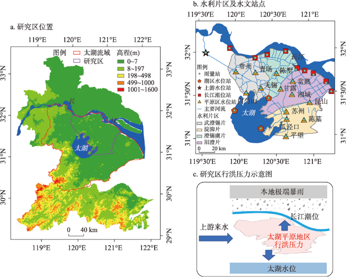
图1
太湖平原地区区位及变化环境下防洪压力示意
Fig. 1
The location of the Taihu Plain region and its flood situation under changing environment
2.2 数据资料
本文系统获取了1971—2020年太湖平原地区逐日水位、降雨、潮位等水文资料。水位站包括平原河网区13个重要控制水文站点和3个太湖湖区站点,其中水文站点反映了平原河网区水文情势,太湖湖区站点(大浦口、望亭、洞庭西山)反映太湖湖区水位。潮位站为分布于沿江9个重要闸门潮位观测站。丹阳站位于江南运河北端,反映平原河网地区上游来水压力。降雨观测站(23个)与分别与水位站和潮位站相匹配,每个站点均有降雨观测资料。各水文站点均经过严格质量控制,空间分布如图1b所示。
2.3 研究方法
本文构建了基于过程尺度的平原河网区洪水事件识别方法,并根据洪水特征进一步划分为局部、区域、和流域不同空间尺度。在此基础上,探讨1971—2020年太湖平原地区不同尺度洪水特征及变化规律。同时,采用随机森林机器学习算法,识别了各尺度洪水的主要影响因素,量化了潮位、上游洪水、本地暴雨、太湖水位等诸要素对各尺度洪水特征指标的影响程度。
2.3.1 基于过程的平原河网地区洪水事件识别与尺度划分
传统洪水事件的分析多是采用特征抽样法,如年最大值和超门限抽样。然而,特征抽样法往往只能关注有限洪水指标,如洪峰流量,而忽略了其他洪水重要特征,如涨幅、涨水速率和退水速率等。同时,抽样法因数据限制导致样本数量往往有限,难以掌握洪水的普遍规律。基于降雨径流的洪水场次划分多应用于山丘区中小流域[23],而平原河网地区水文情势多用水位过程表征,目前尚未有针对平原河网地区洪水事件识别与尺度划分方法,同时,如何划分局部、区域、流域等不同尺度洪水事件目前亦无统一标准。为此,本文构建了平原河网地区基于过程的洪水事件识别与尺度划分方法,来系统揭示太湖地区局部、区域、流域不同尺度洪水特征及演变规律,划分方法及流程如图2所示。
图2
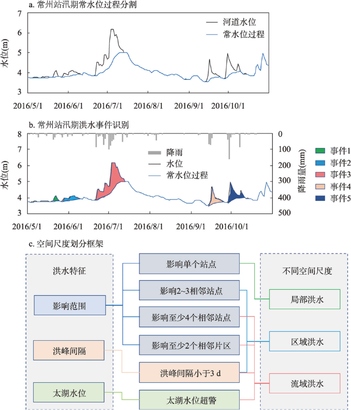
图2
平原河网地区洪水事件识别与空间尺度划分框架
Fig. 2
The framework of flood events identification and spatial scale classification in plain regions
其次,针对降雨水位序列,提取各洪水事件特征指标(表1)。本文主要针对的是可能对平原河网地区产生危害的较大洪水事件,为避免较小量级降雨事件对论文结果的影响,选取洪水事件的洪峰水位均高于年水位序列80%分位数。同时,为排除水利工程调度等非汛期引排水事件的影响,去除了其中未发生降雨过程的事件。
表1 平原河网地区洪水事件及其驱动因素特征指标
Tab. 1
| 水文特征要素 | 指标 | 简写 | 单位 |
|---|---|---|---|
| 降雨 | 总降雨量 | RA | mm |
| 平均降雨强度 | RI | mm/d | |
| 最大降雨强度 | RM | mm/d | |
| 降雨持续时间 | RD | d | |
| 前期(7 d)降雨 | R7 | mm | |
| 潮位 | 起始潮位 | CI | m |
| 最高潮位 | CM | m | |
| 平均潮位 | CA | m | |
| 上游水位 | 上游起始水位 | m | |
| 上游最高水位 | m | ||
| 上游平均水位 | m | ||
| 太湖水位 | 起始太湖水位 | m | |
| 太湖最高水位 | m | ||
| 太湖平均水位 | m | ||
| 洪水 | 起始水位 | m | |
| 洪峰水位 | m | ||
| 洪水涨幅 | m | ||
| 涨水速率 | m/d | ||
| 退水速率 | m/d |
最后,针对洪水事件的空间影响范围,将各洪水事件进一步划分为局部、区域和流域不同空间尺度(图2c)。局部性洪水主要影响单个城市或站点,影响范围相对有限。区域性洪水主要影响2~3个相邻城市或站点,多发生在单个水利片区内,且各站点洪峰水位出现时间间隔不超过3 d。流域性洪水是指对太湖流域影响范围较大的洪水,一般影响范围超过3个相邻城市,同时影响至少两个水利片区,并且太湖湖区水位超警戒水位。太湖流域水系是以太湖为中心的网状水系,太湖高水位直接表征了流域洪水规模及灾害影响,因此选用太湖湖区水位作为表征流域性洪水的指标之一;但由于太湖湖区警戒水位的制定缺乏统一规范和标准,故采用了现行警戒水位标准(3.8 m、2.5 a一遇)[29-30]。
2.3.2 水文特征指标
平原河网区降雨径流过程复杂,影响因素众多,如何识别平原河网地区洪水事件关键主控因子是目前研究的难点。本文选取了降雨、潮位、上游水位、太湖水位和洪水等诸要素特征指标,来全面量化和描述平原河网区暴雨洪水响应过程及其驱动因素(表1)。降雨要素包括总降雨、平均降雨强度、最大降雨强度、降雨持续时间和前期降雨。潮位指标包括起始潮位、最高潮位和平均潮位,用来反映洪水期间长江口门潮位状态。上游水位指标包括起始水位、最高水位和平均水位,反映洪水期间上游来水信息。太湖水位指标包括起始、最高和平均水位,反映洪水期间太湖湖区水位信息。洪水要素特征指标包括起始水位、最高水位、洪水涨幅、涨水速率和退水速率,其中洪水涨幅为最高水位和起始水位差值,涨水速率为洪水涨幅除以涨水时间,退水速率为退水幅度除以退水时间。前期土壤湿度是影响洪水过程的重要因素,由于缺乏该地区长序列土壤墒情监测资料,故选用了前期(7 d)降水、起始水位等指标反映洪水事件发生前的区域前期湿度条件。
2.3.3 驱动因子识别及影响程度分析
随机森林是一种基于决策树的集成机器学习算法,可以较好模拟预测复杂非线性过程。平原河网地区洪水响应过程是典型的非线性响应过程,本文基于随机森林算法,选取主要驱动因子模拟洪水响应特征,量化各主要驱动因子对洪水特征的相对影响程度。随机森林模型是利用Bootstap重抽样对每个样本进行决策树建模,然后组合多棵决策树得出最终预测结果。该算法因其模型结构简单、训练速度快和能够较好处理高维度数据等特点,成为了用途最广泛的监督型机器学习算法之一。
本文选取洪水特征指标(最高水位、洪水涨幅、涨水速率和退水速率)为因变量,降雨、潮位、上游水位、太湖水位和起始水位等因素为自变量,分别构建随机森林回归模型。模拟结果采用决定系数(R2)和平均绝对误差(MAE)评估。为减少随机森林模型的因子重要性排序及贡献率结果的不确定性,本文分别对各因变量进行了100次建模,然后计算每次结果的关键因子排序,统计各因素排序结果的百分比,来反映该因素总体的排序结果的稳健性。例如,假如A因素排序为第1的结果出现百分比为100%,则表明该因素在这100次建模中均排序第1。
3 结果与讨论
3.1 太湖平原地区不同尺度洪水特征
本文提取了1971—2020年太湖平原地区局部、区域和流域不同尺度洪水事件,各尺度洪水特征如图3所示。太湖平原地区局部、区域和流域性洪水分别占11.48%、69.34%和19.17%,该地区洪水主要以区域性洪水为主,其次是流域和局部洪水(图3e)。对于洪峰水位,表现为从局部到区域和流域洪水,洪水峰值逐渐增加;局部和区域洪水峰值较为接近,而流域洪水峰值相对较高(图3a)。洪水涨幅从局部、区域和流域洪水,则表现为明显的增加趋势(图3b)。但对于涨水速率,区域洪水的涨水速率最大,与流域洪水相近,局部洪水涨水速率相对较低(图3c)。退水速率也表现为随洪水尺度增加而增加的趋势(图3d)。这些结果表明区域和流域性洪水一般具有较高的洪峰水位、洪水涨幅、涨水速率和退水速率,反映了区域性洪水和流域性洪水除了在空间上影响范围更大,也具有更大的强度,从而产生更大的破坏。
图3
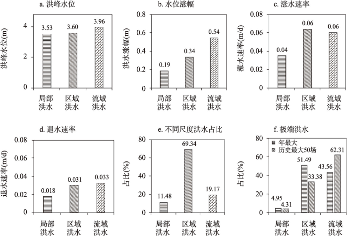
图3
太湖平原地区局部、区域、流域不同尺度洪水特征
Fig. 3
Flood characteristics of different spatial scales (local, regional, and basin scales) in the Taihu Plain region
同时,本文选取了1971—2020年各站点年最大洪水和历史最大50场洪水,用来表征太湖平原地区特大洪水,分析其主要尺度特征(图3f)。对于年最大洪水,不同尺度(局部、区域和流域)洪水占比分别为4.95%、51.49%和43.56%;而从历史最大50场洪水来看,局部、区域和流域洪水分别占比为4.31%、33.38%和62.31%。研究结果表明该地区特大洪水主要是由流域和区域性洪水引起,一般量级较大的洪水影响范围也相对较大,太湖平原地区洪涝防控应重点关注区域和流域性洪水。
3.2 太湖平原地区不同尺度洪水时空变化规律
图4
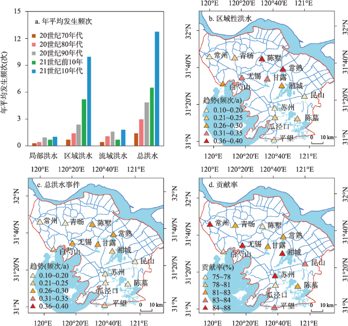
图4
太湖平原地区洪水变化特征及区域性洪水对总洪水事件频次变化趋势的贡献率
Fig. 4
The variation characteristics of floods and the relative contribution of regional floods to annual floods in the Taihu Plain region
自20世纪70年代以来,太湖平原地区局部、区域和流域等不同尺度洪水及总洪水频次总体均呈现上升态势。局部和流域洪水事件年发生频次相对较少,虽总体呈现上升趋势,但在21世纪初10年发生频次相对较低。而区域洪水和总洪水频次自20世纪70年代以来呈现明显上升态势,且在21世纪前20年代上升趋势更为显著。可以发现区域尺度洪水和总洪水事件频次在数值和变化趋势上表现得更为一致,反映了区域尺度洪水变化对研究区总洪水频次变化有较大影响(图4a)。从变化趋势来看,1971—2020年太湖平原地区总洪水频次呈显著增加态势(2.6次/10a,p < 0.001),其中局部性洪水增加幅度不大,区域性洪水亦呈现显著增加趋势(2.1次/10a,p < 0.001),而流域性洪水没有明显变化趋势。1971—2020年该地区洪水次数呈显著增加趋势,主要是由于区域性洪水增加导致的,区域性洪水增加能解释80.8%太湖平原地区年洪水频次的变化趋势。研究区在20世纪70年代洪水次数整体相对较少(1.39次/a),这主要由于在20世纪70年代初研究区处于典型枯水年,导致洪水频次相对较低[31]。
从空间来看,太湖平原地区各站点总洪水和区域性洪水具有很好的一致性,也反映了区域性洪水的增加是该地区洪水增加的主要原因(图4b、4c)。由于大部分站点局部性洪水和流域性洪水变化趋势较小且不通过显著性检验,故只显示了年总洪水频次(图4b)和区域性洪水(图4c)的变化趋势。研究区洪水整体变化趋势也存在一定差异,中部地区站点(无锡、甘露、常熟和陈墅等)变化趋势较大(达3次/10a),而南北地区站点变化趋势相对较低(1.2次/10a)。对于区域性洪水,其空间变化区域与总体洪水具有较好一致性,也表现出中部地区较大,南北地区相对较低。从贡献率来看,区域性洪水变化对研究区洪水变化起到了主导作用,其贡献率在各站点均超过75%,而在江南运河沿线重要城市(如苏州、无锡和常州等)贡献率达84%以上(图4d)。
3.3 太湖平原地区不同尺度洪水主控因子及其影响程度
为进一步探讨不同尺度洪水的主控因子及其影响机制,本文首先计算了不同洪水特征和各主要驱动因素之间相关性,分析不同洪水特征的主要驱动因子;然后采用随机森林方法模拟了太湖平原地区局部、区域和流域洪水特征,并量化了各主要驱动因子的相对贡献率。
3.3.1 不同尺度洪涝特征与潜在驱动因素之间的相关性
图5显示了太湖平原地区不同尺度洪水特征与潜在驱动因素之间的相关性。对于局部性洪水,洪峰水位与大部分驱动因素均呈现显著性相关关系,其中与FI相关性最高;洪水涨幅与RD、RA、RM和UM相关性较强;而涨水速率与RA、RM、RI、UM和UA呈现显著正相关关系,而与TI、TM和TA呈现显著负相关关系;退水速率主要与CI、CM、CA、TI、TM、TA、和UI呈现显著负相关关系,表明潮位、太湖水位和上游水位对局部性洪水退水过程有较大影响。而对于区域和流域性洪水,洪峰水位、洪水涨幅与涨水速率与驱动因素相关性与局部性洪水较为类似,不过显著性相关的因子相对局部性洪水较多;但对于区域与流域性洪水的退水速率,与潮位和上游水位多表现为显著正相关关系。整体来看,太湖平原地区不同洪水特征与潜在驱动因素多表现为显著性相关关系,说明潜在驱动因素选取较为合理。
图5
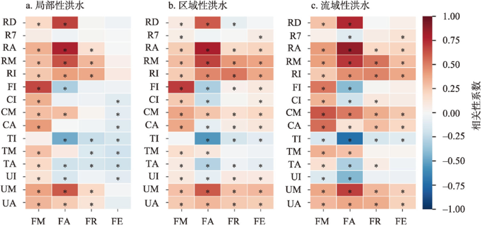
图5
太湖平原地区不同尺度洪水的特征指标与驱动因素之间相关性
注:*表示p < 0.05。
Fig. 5
The correlation between flood characteristics and their driving factors at different spatial scales in the Taihu Plain region
3.3.2 主控因子重要性排序及相对影响程度
不同因子之间可能具有一定的相关性,虽然随机森林回归模型不需要考虑一般回归分析面临的多元共线性问题,但为了便于量化不同因子之间的相对贡献率,本文在变量两两相关性分析的基础上,去除了共线性较高的变量,最终选取了R7、RA、FI、CM、TM和UM等变量作为主要驱动因子建模,以分别量化前期降雨、总降雨量、起始水位、潮位、太湖水位和上游水位对不同洪水特征的贡献率。随机森林对于局部、区域和流域性洪水各洪水特征模拟结果的R2平均值分别为0.91、0.95和0.95,MAE分别为0.03、0.02和0.03,表明其对于各尺度洪水的特征指标均具有较高的模拟精度,可用来分析该地区洪水特征的影响因素。图6和表2为构建的100次随机森林模型各驱动因子的重要性排序及其对各洪水特征影响的相对贡献率。
图6
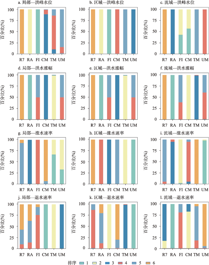
图6
不同空间尺度洪水特征指标的影响因素排序
Fig. 6
The importance ranking of influencing factors for flood characteristics at different spatial scales
表2 不同尺度洪水特征受主控因子影响的相对贡献率(%)
Tab. 2
| 不同尺度 | 洪水特征 | R7 | RA | FI | CM | TM | UM |
|---|---|---|---|---|---|---|---|
| 局部洪水 | 洪峰水位 | 1.95 | 22.88 | 53.20 | 8.31 | 7.19 | 6.46 |
| 洪水涨幅 | 4.19 | 64.91 | 6.11 | 8.48 | 10.19 | 6.13 | |
| 涨水速率 | 9.70 | 16.06 | 12.72 | 8.65 | 27.03 | 25.84 | |
| 退水速率 | 3.85 | 4.00 | 4.98 | 41.54 | 30.34 | 15.28 | |
| 区域洪水 | 洪峰水位 | 2.22 | 21.45 | 54.98 | 5.15 | 4.22 | 11.98 |
| 洪水涨幅 | 3.89 | 65.01 | 6.09 | 7.69 | 7.72 | 9.59 | |
| 涨水速率 | 10.07 | 15.98 | 17.48 | 12.22 | 19.38 | 24.87 | |
| 退水速率 | 13.60 | 12.68 | 21.25 | 11.82 | 16.59 | 24.05 | |
| 流域洪水 | 洪峰水位 | 2.49 | 17.91 | 33.61 | 34.04 | 5.00 | 6.94 |
| 洪水涨幅 | 2.85 | 78.72 | 3.70 | 6.71 | 4.30 | 3.73 | |
| 涨水速率 | 11.84 | 15.15 | 25.13 | 13.64 | 7.31 | 26.93 | |
| 退水速率 | 17.47 | 21.79 | 14.85 | 18.39 | 14.42 | 13.08 |
对于洪峰水位,局部洪水主要受到前期水位的影响,相对贡献率占比53.2%;区域洪水与局部洪水类似,也主要受到前期水位的影响(相对贡献率占比54.98%),且模拟结果稳健性较高;流域性洪水则主要受到潮位和前期水位的影响,分别占比34.04%和33.61%。洪水涨幅则主要受到降雨量的影响,其对局部、区域和流域性洪水影响的相对贡献率分别为64.91%、65.01%和78.72%(表2);且模拟中排序为第一的结果占比均达100%,说明不同模拟结果较为一致(图6d~6f)。不同尺度洪水涨水速率的主要驱动因素则存在一定差异,局部性洪水涨水速率主要受到太湖和上游水位影响(贡献率分别为27.03%和25.84%)(表2),不同模型之间存在一定不确定性(图6g);区域性洪水涨水速率上游水位和太湖水位影响,贡献率分别为24.87%和19.38%(表2,图6h);而流域性洪水主要受到上游水位影响,贡献率占26.93%(表2、图6i)。不同尺度洪水退水速率所受的驱动因素也存在较大差异,局部性洪水主要受到潮位和太湖水位影响,贡献率分别占41.54%和30.34%;区域性洪水主要受到上游和太湖水位影响(贡献率分别占24.05%和21.25%),流域性洪水则主要受到总降雨量的影响(贡献率占21.79%)。
同时,针对每个站点也分别构建了随机森林模型,从而分析不同尺度洪水受各主控因子影响的空间差异(图7)。对于洪峰水位,环太湖站点局部性洪水主要太湖水位影响,中部地区站点主要受起始水位影响;区域性和流域性洪水则主要受上游水位和太湖水位影响,研究区中东部站点流域性洪水主要受到总降雨量影响(图7a~7c)。不同尺度洪水水位涨幅主要受到总降雨量和起始水位的影响(图7d~7f),而涨水速率则主要受到太湖水位和上游水位的影响(图7g~7i)。局部性洪水退水速率主要受到太湖水位影响,且环太湖站点影响相对较大;区域性洪水研究区西部地区退水速率主要受到潮位影响,中部地区主要受到上游水位影响。流域性洪水退水速率主要受到总降雨量影响,其中在研究区中东部影响相对较大。
图7
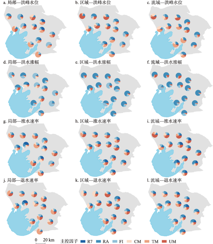
图7
不同尺度洪水特征受各驱动因素影响的相对贡献率的空间分布(%)
Fig. 7
The spatial distribution of the relative contributions of influencing factors for flood characteristics at different spatial scales (%)
综合来看,太湖平原地区洪水成因复杂,不同尺度洪水特征的主要驱动因素及其影响存在空间差异,准确识别洪水峰值、洪水涨幅、涨水速率和退水速率等洪水特征变量的关键驱动因子及其贡献将对平原河网地区防洪减灾具有重要指示意义。同时,不同尺度洪水危害也存在一定差异,揭示太湖平原地区局部、区域和流域洪水形成机理将为该地区防洪减灾提供一定参考。
3.4 讨论
相关学者针对太湖地区极端水位变化及其驱动因素也开展了分析,发现该地区极端水位由于受到了气候变化引起的极端降雨和潮位变化而呈现显著上升趋势[21]。本文进一步揭示了太湖平原地区不同尺度洪水主控因子及其影响程度,发现太湖地区洪水受到了降雨、潮位、太湖水位、上游洪水、前期水位等多因素制约,量化了各因素对不同尺度洪水的贡献率。从1971—2020年太湖平原地区水位、长江潮位、降雨和太湖水位变化趋势来看,长江潮位和太湖水位的汛期平均和年最大值均呈现显著性上升趋势,汛期和年最大降雨呈现不显著的上升趋势(图8)。这表明该地区遭遇极端降雨、长江潮位和太湖水位等多要素“碰头”情况增多,从而导致极端洪涝灾害增加,研究区汛期平均和年最大水位亦呈现显著性上升趋势(分别为11.31 mm/a和12.31 mm/a),与珠三角等地区研究结果一致[33-34]。
图8
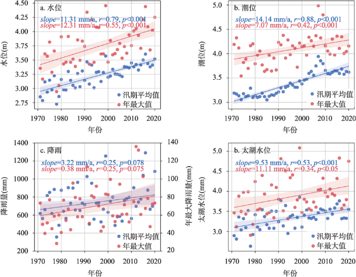
图8
1971—2020年研究区汛期和年最大水位、潮位、降雨、太湖水位变化趋势
Fig. 8
The variation trends of annual average for flood season and annual maximum value for water level, tidal level, rainfall and water level of the Taihu Lake in the Taihu Plain region during 1971-2020
本文结果表明太湖平原地区洪水事件呈现显著增加趋势,主要由区域性洪水增加导致。一方面,主要是由于该区域极端降雨增加、长江潮位和太湖水位持续上涨,导致平原河网地区洪水易涨难消。另一方面,下垫面特征(如土地利用、河网水系等)变化也是影响洪水响应的重要因素,太湖平原地区河网密布,随着城市化快速发展,不透水面快速扩张,侵占大量河网水系,导致洪水产蓄矛盾突出[13,35];同时,平原河网地区大规模圩垸工程建设,保护了城市地区但同时也使得洪水风险向郊区转移,导致洪水从城市向郊区转移,使得区域性洪涝灾害加剧[14]。近年来,相关从全球暴雨和全国洪水等角度的研究也表明中国南部地区暴雨和洪水空间范围增大,洪水量级增加[19,36]。同时,Yang等[37]通过对全国站点年最大洪水资料分析发现,自20世纪60年代以来洪水同步发生范围呈现显著增加趋势,在20世纪70年代前洪水发生范围相对较小,发生频率相对较低,与本文中洪水尺度变化规律也较为一致。相关研究结果表明,变化环境背景下若不采取相应科学防洪减灾适应性对策,未来洪水发生范围还将呈现持续增加趋势[19,37]。为此,本文对太湖平原或者类似河口三角洲地区应对变化环境下洪涝灾害提供了一些参考和建议:① 应重点关注区域性洪水问题,加强区域防洪工程调度,协调区域洪涝风险,坚持城郊“利益共享、风险共担”防洪调度模式;② 应加强沿江、环湖提防工程建设,提高平原地区防洪能力,变化环境下太湖洪水位和长江潮位持续攀升,多致洪要素“碰头”情形可能性增加,平原地区排涝形势愈发严峻;③ 在城市化过程中,应避免大规模侵占河网水系,需控制不透水面比例,缓解城市化地区洪水“产蓄”矛盾。
由于观测资料限制,本文主要基于太湖平原地区重要水文控制站点分析了1971—2020年不同尺度洪水演变及形成规律,但对于洪水空间分布规律存在一定以点代面问题,后续将进一步开展平原河网区洪水过程模拟,更为精细地揭示研究区洪水形成及空间尺度变化规律。同时,在驱动因素量化分析中,考虑了降雨、潮位、上游水位、太湖水位和起始水位等主要致洪因子,但下垫面特征(如土地利用/覆被、河网水系)等也是影响水文情势的重要因素,后续可结合水文水动力学模型,进一步量化各驱动因素的贡献。平原河网地区洪水主要通过水位过程来表征,本文主要选取了洪峰水位、洪水涨幅、涨水速率和退水速率等特征指标,如何进一步刻画平原河网地区洪峰流量和洪水总量等洪水指标,还有待后续进一步研究。
4 结论
(1)太湖平原地区洪水表现出明显的尺度差异,1971—2020年主要以区域性洪水为主,其次为流域性洪水及局部性洪水,分别占比69.34%、19.17%和11.48%。区域性和流域性洪水具有较大的影响范围,同时也具有更大的强度,从而产生更大的破坏。该地区年最大和最大50场洪水主要为流域和区域性洪水。
(2)1971—2020年太湖平原地区洪水频次呈显著增加趋势(2.6次/10a),主要是由于区域性洪水增加(贡献率达80.8%)。区域性洪水增加对年洪水频次增加的影响存在一定空间差异,但贡献率均超过75%,江南运河沿线重要城市(如苏州、无锡和常州等)贡献率达84%以上。局部性和流域性洪水变化趋势不明显。
(3)太湖平原地区不同尺度洪水的特征指标与降雨、长江潮位、太湖水位、上游来水等因素多表现为显著性相关关系,反映了洪水成因较为复杂。前期水位是研究区局部性和区域性洪水峰值主要驱动因素,贡献率分别占53.2%和54.98%,而流域性洪水峰值则主要受到潮位和前期水位的影响,分别占比34.04%和33.61%。洪水涨幅则主要受到降雨量的影响,其对局部、区域和流域性洪水影响的相对贡献率分别为64.91%、65.01%和78.72%。不同尺度洪水涨水速率的主要受到太湖和上游水位影响。局部性洪水退水速率主要受到潮位影响(贡献率占41.54%),区域性洪水主要受到上游水位影响,流域性洪水则主要受到总降雨量的影响(贡献率占21.79%)。
参考文献
Development and challenges of urban hydrology in a changing environment: I. Hydrological response to urbanization
变化环境下城市水文学的发展与挑战: I.城市水文效应
Progress and prospect of hydrological sciences
DOI:10.18306/dlkxjz.2018.01.005
[本文引用: 1]

Hydrology is the science that describes the continuous movement of water, the related biogeochemical and geophysical processes, and their interactions with the environment. Hydrology research has evolved from experience-based to theories, from single process to complex systems, and from qualitative interpretations to quantitative models. The progress and evolution of hydrology has been intimately intertwined with the scientific and technological progresses and socioeconomic development, which creates many branches and interdisciplinary areas of hydrology, such as ecohydrology, hydrometeorology, cryosphere hydrology, hydrologic remote sensing, isotope hydrology, urban hydrology, and socio-hydrology. Hydrology research has made notable progress in the fields of multi-scale observations, coupled land surface-hydrology-society modeling, and multi-source data and model assimilation techniques, which further expands the connotation of hydrological study. In the future, hydrology research will focus on the characteristics and mechanism of the changes of water cycle, prediction of the changes of water cycle, and natural and social impact assessment of the changes of water cycle, in order to offer sustainable solutions to water security. In summary, the research paradigm of hydrology would shift from the traditionally self-focused approaches to the emerging integrated approaches that focus on all the water-related processes across multiple scales and sectors in the earth system.
水文学研究进展与展望
DOI:10.18306/dlkxjz.2018.01.005
[本文引用: 1]
水文学是研究地球上水的起源、存在、分布、循环运动等变化规律,并运用这些规律为人类服务的知识体系。水文学研究经历了由经验到理论、由简单过程到复杂系统、由定性描述到定量模拟的发展历程,其学科体系演进与科学技术进步及社会发展需求紧密联系,并由此衍生出诸如生态水文学、气象水文学、冰冻圈水文学、遥感水文学、同位素水文学、城市水文学、社会水文学等多种交叉研究领域与分支学科。当今水文学研究在水文多尺度观测、陆面—水文—社会耦合模拟及多源观测—模型同化技术等领域取得显著进展,水文学研究的广度和深度不断拓展。未来水文学研究将面向陆地水文循环的变化规律及其效应,重点关注水文循环变化特征和机理、水文循环变化趋势预估及水文循环变化的自然和社会影响等前沿课题;从原有就水论水研究思路转向在自然地理综合分析框架下以水循环为纽带开展的多尺度、多过程集成研究。
Basic theory for urban water management and sponge city: Review on urban hydrology
城市水管理与海绵城市建设之理论基础: 城市水文学研究进展
Review on urban hydrology
城市水文学研究综述
Innovative development and prospect of physical geography
DOI:10.11821/dlxb202012002
[本文引用: 1]
Physical geography (PG) has always been the core discipline of the Institute of Geographic Sciences and Natural Resources Research, Chinese Academy of Sciences (IGSNRR, CAS) since its establishment in 1940. It aims to serve the grand needs of national development. PG has made significant scientific and technological achievements and progress in the fields of comprehensive physical geography, climatology, geomorphology, hydrology, soil geography, biogeography, chemical geography, etc. These achievements have set up the worldwide priority status of PG, and made great contributions to the scientific and technological innovation, regional sustainable economic and social development. This paper reviews the innovative development of PG in the IGSNRR, summarizes the academic achievements and landmark progress, and looks forward to the future development strategy. Four key points are presented including the interaction mechanism of land surface elements-process, the dynamics of land surface pattern, the comprehensive integration and simulation of process of land surface system, and the sustainable paradigm and regulation mechanism of orderly human activities of land surface system.
自然地理学创新发展与展望
DOI:10.11821/dlxb202012002
[本文引用: 1]
自然地理学自中国科学院地理科学与资源研究所建立以来一直是立所的核心学科,长期以服务国家重大需求为使命,在综合自然地理、气候、地貌、水文、土壤地理、生物地理、化学地理等各学科领域取得一批重要科技成果和进展,奠定了自然地理各分支学科在国内外的优势,为国家科技创新、区域经济社会可持续发展做出了重要贡献。本文回顾了中国科学院地理科学与资源研究所自然地理学的创新发展历程,总结了自然地理学取得的学术成就与标志性进展,并展望了中国科学院地理科学与资源研究所自然地理学未来发展,提出以陆地表层要素—过程交互作用机制,陆地表层格局动态研究,陆地表层系统过程的综合集成与模拟,陆地表层系统有序人类活动的可持续范式和调控机制为核心的发展战略。
Spatial dependence of floods shaped by spatiotemporal variations in meteorological and land: Surface processes
Discussion on the urban flood and waterlogging and causes analysis in China
中国城市洪涝问题及成因分析
Urban impacts on extreme monsoon rainfall and flooding in complex terrain
DOI:10.1029/2019GL083363 URL [本文引用: 1]
Globally observed trends in mean and extreme river flow attributed to climate change
DOI:10.1126/science.aba3996
PMID:33707264
[本文引用: 1]
Anthropogenic climate change is expected to affect global river flow. Here, we analyze time series of low, mean, and high river flows from 7250 observatories around the world covering the years 1971 to 2010. We identify spatially complex trend patterns, where some regions are drying and others are wetting consistently across low, mean, and high flows. Trends computed from state-of-the-art model simulations are consistent with the observations only if radiative forcing that accounts for anthropogenic climate change is considered. Simulated effects of water and land management do not suffice to reproduce the observed trend pattern. Thus, the analysis provides clear evidence for the role of externally forced climate change as a causal driver of recent trends in mean and extreme river flow at the global scale.Copyright © 2021 The Authors, some rights reserved; exclusive licensee American Association for the Advancement of Science. No claim to original U.S. Government Works.
Effects of precipitation on flood variations in Daqinghe river basin
降雨因素对大清河流域洪水径流变化影响分析
The effect of land use on runoff in Shenzhen city of China
深圳市土地利用变化对流域径流的影响
Urbanization exacerbated the rainfall and flooding caused by hurricane Harvey in Houston
DOI:10.1038/s41586-018-0676-z [本文引用: 1]
Influence of stream structure change on regulation capacity of river networks in Taihu Lake Basin
太湖平原区河网结构变化对调蓄能力的影响
Change in return period of storm flood in plain river network area under urbanization: Taking Wuchengxiyu region of Taihu Lake basin as a case study
城镇化背景下平原河网区暴雨洪水重现期变化分析: 以太湖流域武澄锡虞区为例
Changing climate shifts timing of European floods
DOI:10.1126/science.aan2506
PMID:28798129
[本文引用: 1]
A warming climate is expected to have an impact on the magnitude and timing of river floods; however, no consistent large-scale climate change signal in observed flood magnitudes has been identified so far. We analyzed the timing of river floods in Europe over the past five decades, using a pan-European database from 4262 observational hydrometric stations, and found clear patterns of change in flood timing. Warmer temperatures have led to earlier spring snowmelt floods throughout northeastern Europe; delayed winter storms associated with polar warming have led to later winter floods around the North Sea and some sectors of the Mediterranean coast; and earlier soil moisture maxima have led to earlier winter floods in western Europe. Our results highlight the existence of a clear climate signal in flood observations at the continental scale.Copyright © 2017 The Authors, some rights reserved; exclusive licensee American Association for the Advancement of Science. No claim to original U.S. Government Works.
Growing spatial scales of synchronous river flooding in Europe
DOI:10.1029/2018GL081883
[本文引用: 1]
River flooding is a common hazard, causing billions of dollars in annual losses. Flood impacts are shaped by the spatial scale over which different rivers flood simultaneously, but this dimension of flood risk remains largely unknown. Using annual flood data from several thousand European rivers, we demonstrate that the flood synchrony scale-the distance over which multiple rivers flood near synchronously-far exceeds the size of individual drainage basins and varies regionally by more than an order of magnitude. These data also show that flood synchrony scales have grown by about 50% over the period 1960-2010. Detrended flood synchrony values are serially correlated, implying that years with spatially extensive floods tend to follow one another. These findings reveal that flood risks are correlated well beyond the individual drainage basins for which flood hazards are typically assessed and managed. Plain Language Summary When rivers flood, surrounding rivers often flood at the same time. This synchronization of floods amplifies their impacts. We show that the distance over which multiple rivers flood near synchronously varies strongly across Europe, and these distances have grown by about 50% over the period 1960-2010. Risk finance, flood forecasting, and interpretations of flood trends can be improved by accounting for how flood risks extend beyond the borders of individual drainage basins.
Joint trends in flood magnitudes and spatial extents across Europe
Climate leads to reversed latitudinal changes in Chinese flood peak timing
Variability of precipitation extremes over the Yangtze River Delta, Eastern China, during 1960-2016
DOI:10.1007/s00704-019-02829-5 [本文引用: 1]
Atmospheric and human: Induced impacts on temporal variability of water level extremes in the Taihu Basin, China
Attribution of climate change and human activities to urban water level alterations and factors importance analysis in Central Taihu Basin
Exploring controls on rainfall-runoff events: 1. Time series: Based event separation and temporal dynamics of event runoff response in Germany
DOI:10.1029/2018WR022587 URL [本文引用: 1]
Stochastic time-variable rainfall-runoff modelling
Evaluation of automated techniques for base flow and recession analyses
HydRun: A MATLAB toolbox for rainfall-runoff analysis
DOI:10.1002/hyp.v31.15 URL [本文引用: 1]
Baseflow separation in a small watershed in New Brunswick, Canada, using a recursive digital filter calibrated with the conductivity mass balance method
DOI:10.1002/hyp.v27.18 URL [本文引用: 1]
Digital filter baseflow separation method based on a master recession curve
结合退水曲线的数字滤波基流分割方法
Studies on warning water level of Taihu Lake
太湖警戒水位研究
Flood identification and constraints analysis for flood resources utilization in Taihu Lake basin
太湖流域洪水识别与洪水资源利用约束分析
Temporal and spatial changes of extreme water levels in the typical regions of Taihu Lake basin since the 1950s
DOI:10.11821/yj2011060011
[本文引用: 1]
Taking Wuchengxiyu and Yangchengdianmao regions as examples, the paper investigates the temporal and spatial changes of extreme water levels in the river networks of Taihu Lake basin. The improved MK test and homogeneity test are used to detect trend and change points in the series of maximum and minimum water levels, and Kriging and semivariogram methods are adopted to analyze the spatial characteristics of water level changes. Furthermore, the relationship among extreme water levels, precipitation and human activities are discussed. Some meaningful results are obtained as follows. As for temporal changes, there is a global increasing trend in both the low water level (LWL) and high water level (HWL), with the increase of LWL being more significant than that of HWL. Both LWL and HWL experienced an abrupt change around the 1980s. What's more, the temporal variations of annual HWL are bigger than those of the LWL. As for spatial changes, the results of contour analysis show that the maximum increment magnitudes of HWL and LWL are observed in Yangchengdianmao Region. And the gradient of HWL and LWL variation coefficients is on the rise, indicating that their spatial variability has increased. Besides, the spatial autocorrelation of extreme water levels has been weakened after the abrupt change according to semivariogram analysis, which might be mainly due to the extensive human disturbance. The paper comes to the conclusion that there are differences between the characteristics of extreme water level changes and rainfall variations in the study region, and anthropogenic influences have played more and more important roles in the process of water level changes.
太湖流域典型区50年代以来极值水位时空变化
Evaluation on the impact of climate change on risk of combination of rainfall and tidal levelin Guangzhou city
气候变化对广州市城市雨潮遭遇风险的影响评估
Modeling and design on joint distribution of precipitation and tide in the coastal city
滨海城市雨潮遭遇联合分布模拟与设计
Stream structure characteristics and their impact on storage and flood control capacity in the urbanized plain river network
平原河网地区河流结构特征及其对调蓄能力的影响
Global changes in the spatial extents of precipitation extremes
Understanding the variability of spatial extents of precipitation extremes favors an accurate assessment of the severity of disasters caused by extreme precipitation events. Using a restricted neighborhood method, we identify the spatial extents of global precipitation extremes over 1983–2018 and examine their spatiotemporal variability and associated changes. Results show that the mid-latitudes shows the largest spatial extent of precipitation extremes, and the spatial extents in non-tropical regions over the Northern Hemisphere show significant seasonal differences. In non-monsoon regions, the spatial extents of precipitation extremes in autumn and winter are larger than those in spring and summer, and the annual average spatial extents of precipitation extremes all exceed 500 km, which are larger than those in monsoon regions. All the five non-monsoon regions over the Northern Hemisphere and three monsoon regions in the western Pacific show statistically significant increases in the spatial extent of precipitation extremes in most seasons.
Climate more important for chinese flood changes than reservoirs and land use
