

1 引言
以往的研究表明,温度和降水是限制植被生长发育的关键气候因子[12]。但针对不同的生态地理分区,温度和降水对植被影响的效果和程度存在巨大差异。在干旱地区,植被生长主要受到土壤水分的限制[13];而在高寒地区,温度是限制植被生长的重要因素[14]。在一定程度上,温度升高能加强植被的光合作用以及延长生长季等[15],而降水能够提供植被生长必需的水分,促进植被的生长。需要指出的是,温度和降水对植被的作用并非是线性增强的关系,过高的温度和过量的降水造成的极端气候同样会对植被产生负面影响[16-17]。此外,人类活动对植被动态的影响也具有两面性。一方面,退耕还林、封山造林和天然林保护等生态工程增加了植被覆盖度[18]。另一方面,城市扩张、过度放牧、开垦和砍伐等活动导致了植被覆盖度下降[19-20]。以往的研究表明,21世纪之前,由于不合理的人类活动导致了中国部分地区出现土地退化现象[21]。进入21世纪以后,退耕还林工程有效的遏制了这些地区的恶化趋势[22],特别是在黄土高原和南方丘陵地带[23]。
虽然气候变化和人类活动共同影响植被动态已成为广泛共识,但对于如何量化气候变化和人类活动对植被动态的贡献仍存在一些问题。目前针对人类活动对植被动态影响的研究中,主要采用残差趋势分析法,通过建立植被与气候变量的关系,分离气候变化与人类活动对植被造成的影响,以达到量化人类活动对植被动态的贡献作用[24]。但这个方法仍存在一些问题,以往的研究表明,在远离人类活动区域时,人为因素对植被的影响会逐渐减弱直至消失[25-26],而残差分析是基于像元尺度对人类活动的影响进行量化,这在很大程度上高估了人类活动对植被造成的影响。鉴于此,本文根据1982—2019年8期土地利用数据,分离出受人类活动影响的区域,这在一定程度减少了人类活动对植被动态影响的不确定性。
以往有关中国植被动态的研究主要聚焦于黄土高原和青藏高原等生态脆弱区[12],而针对中国西南地区的研究较少,同时仅有的研究仍存在研究时间短、研究范围小、分辨率低的问题,并且这些研究主要针对气候变化与植被动态的关系进行阐述,缺少针对人类活动对植被动态影响的评估。作为中国最大的碳汇地区[27],对西南地区的研究重视程度明显存在不足,因此有必要针对西南地区开展植被动态和归因研究。鉴于此,本文以NDVI为指标,结合气温、降水和土地利用数据,采用趋势分析、偏相关分析和残差趋势分析在像元尺度探究了1982—2019年中国西南地区植被动态特征及其与气候变化和人类活动的关系,以期为中国植被保护和建设做出科学建议。
2 数据与方法
2.1 研究区概况
本文以中国西南地区为研究对象(97°21′E~112°04′E、20°54′N~34°19′N)(图1),研究区包含3个省级行政区、1个直辖市和1个自治区。研究区地形走势为西北高,东南低,地貌复杂多样,包含山地、高原、盆地、丘陵和平原等众多地貌[28],主要由西北部横断山脉、东北部四川盆地、中部云贵高原和东南部广西丘陵组成[29]。由于季风气候和地形因素影响,造就了研究区气候类型多样,自西向东,主要以高原气候、热带季节性雨林气候和亚热带季风气候为主。研究时段内研究区年均温度为13.52 ℃,年均降水量为1100.03 mm,温度和降水空间分布与地形相似。研究区人口分布不均,人口主要集中分布于东部地区[30]。
图1
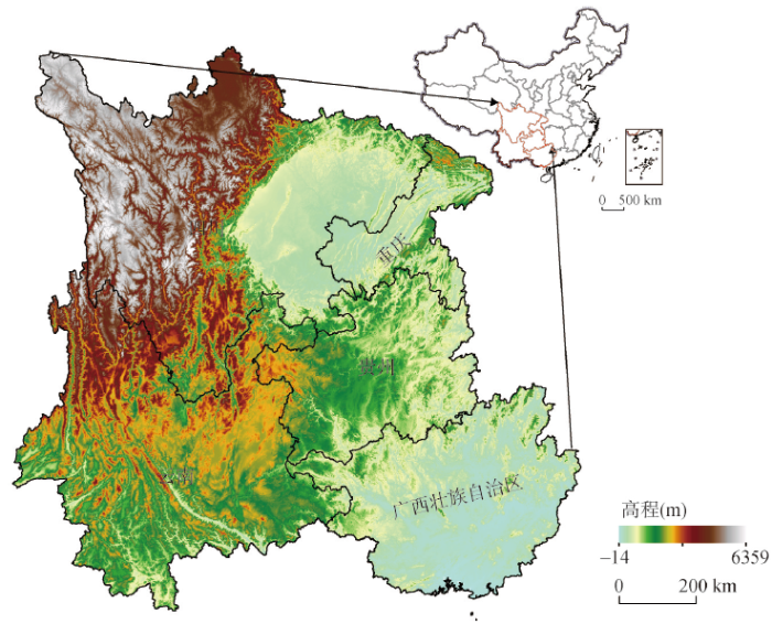
图1
中国西南地区位置和地形空间分布
Fig. 1
Location and spatial distribution of topography in Southwest China
2.2 数据
2.2.1 NDVI
NDVI数据来源于GIMMS NDVI数据集(时空分辨率分别为15 d和8 km,时间跨度为1981年7月—2015年12月)(
2.2.2 其他数据
温度和降水数据来源于国家青藏高原科学数据中心(
用于分离人类活动和气候变化影响区域的土地利用数据来源于资源环境科学与数据中心(
2.3 方法
2.3.1 一元线性趋势分析
线性趋势分析常被用于分析变量的变化强度和趋势[33]。本文中,线性方程的斜率被定义为像元上NDVI的年际变化趋势。其公式如下:
式中:Slope表示NDVI与时间变量拟合的斜率;i表示第i年;NDVIi表示第i年像元上的NDVI值;n为总年数(在本文中n = 38)。当Slope > 0时,说明植被情况得到改善;反之表示植被情况恶化。
2.3.2 偏相关分析
本文采用偏相关分析研究温度和降水对NDVI变化的影响。当存在NDVI与双气候变量时,偏相关分析可以有效避免另一个气候变量造成的影响,获取单一气候变量对NDVI的影响程度[34]。其公式如下:
式中:T表示温度;P表示降水量;
2.3.3 残差趋势分析
本文采用残差趋势分析用以区分和量化人类活动与气候变化对NDVI造成的影响[36],这种方法已广泛应用于植被动态研究中[12]。该方法通过建立植被指数与气候因子之间的回归方程,将人类活动对NDVI的影响(残差)看作植被动态中无法解释的变化[37]。由于该方法本身存在缺陷,为了降低这种干扰,本文分离出受到人类活动影响的区域,通过监测1980—2020年共计八期土地利用类型的变化(1980年和2020年土地利用类型数据分别代表1982和2019年土地利用类型数据),分离出研究区40年间土地类型发生改变的地区、农田和建筑区(图2),这些地区的植被变化被定义为受到人类活动和气候变化的综合影响(LCC+HA),而其他地区植被变化则由气候变化解释(LCC)[38],其中LCC+HA地区占研究区总面积的61.02%,LCC地区占研究区总面积的38.98%。
图2
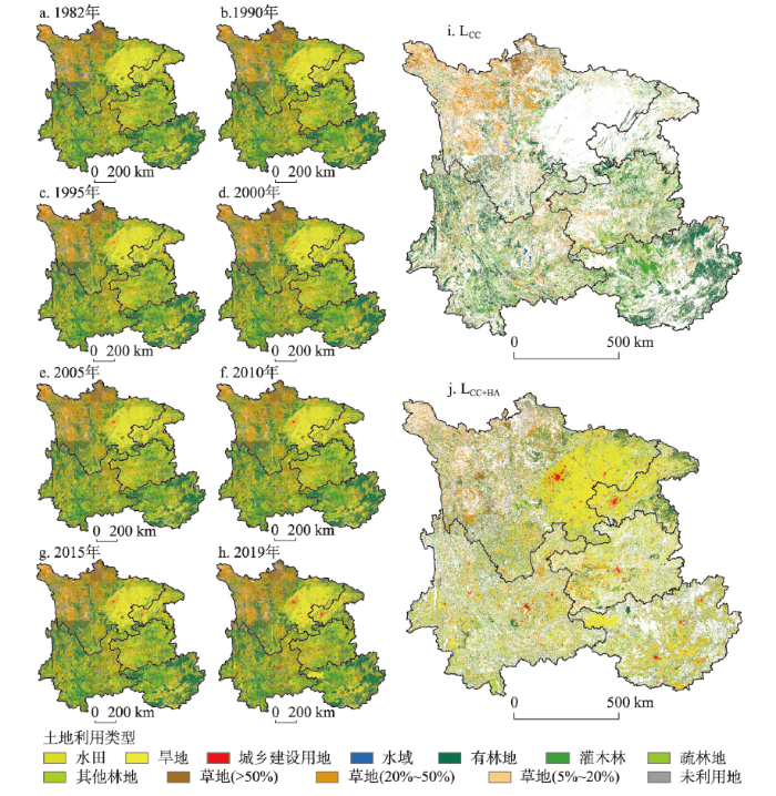
图2
1982—2019年西南地区受气候变化影响(LCC)和受气候变化与人类活动综合影响(LCC+HA)的植被分布
Fig. 2
Distribution of vegetation affected by climate change (LCC) and by combined climate change and human activities (LCC+HA) in Southwest China from 1982 to 2019
基于此地区以往的研究,西南地区植被变化对降水和温度变化的响应更明显[39],本文采用NDVI与降水和温度之间建立回归方程,用于分析气候变化和人类活动对NDVI的相对影响。其公式如下:
式中:T和P分别为年均温度和年降水量;NDVIpre表示为在无人为因素干预下的NDVI预测值;NDVIact为NDVI实际值;NDVIres为回归方程残差,即人类活动对NDVI造成的影响;a、b和c为回归方程常数。将NDVIpre和NDVIres进行趋势分析,得到气候变化和人类活动对NDVI变化的相对贡献。
3 结果
3.1 NDVI时空动态特征
西南地区NDVI空间分布如图3a所示。1982—2019年西南地区NDVI均值为0.7353,其中LCC地区NDVI均值为0.7441,LCC+HA地区NDVI均值为0.7295,两者之间相差并不明显,两种地区NDVI空间分布类似,由西北向东南延伸,逐渐增大。实施退耕还林工程前(1982—1999年),西南地区NDVI均值为0.7192,实施退耕还林工程后(2000—2019年)NDVI均值为0.7514,实施退耕还林工程后西南地区NDVI平均增加0.0322,这表明退耕还林工程对西南地区植被保护取得了较为明显的进展。
图3
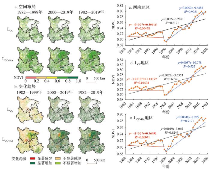
图3
1982—2019年西南地区3个时期NDVI空间分布及变化趋势
Fig. 3
Spatial distribution and variation in the NDVI of three periods in Southwest China from 1982 to 2019
图3b表明了西南地区NDVI空间变化主要以增加为主,但存在明显的空间异质性。1982—2019年西南地区NDVI增速为0.0020 a−1,LCC+HA和LCC地区的NDVI变化趋势表现出类似的空间特征,表明38 a间无论是气候变化的单一影响还是人类活动与气候变化的综合影响总体上均促进了西南地区NDVI的增加。相较于实施退耕还林工程后,实施退耕还林工程前NDVI以减少为主,但仍存在NDVI显著增加的地区,其主要分布在四川盆地腹部以及广西丘陵南部等农业地区,这表明农耕生产技术的提升有效的促进了各农业地区NDVI的增加。实施退耕还林工程后西南地区NDVI以增加为主,呈显著减少的地区仅占研究区总面积的2.99%,且主要分布于LCC+HA的四川盆地西部等中心城市及周边地区,这表明城市扩张无可避免的对植被造成了一定的破坏作用。
从研究区整体、LCC和LCC+HA地区NDVI的时间变化来看(图3c~3e),1982—2019年不同地区NDVI均呈增加趋势,增加速率分别为0.0020 a−1、0.0022 a−1和0.0019 a−1;在实施退耕还林工程前,不同地区NDVI均呈减少趋势;实施退耕还林工程后,NDVI均呈增加趋势。在LCC+HA地区,实施退耕还林工程前NDVI减少速度最快,实施退耕还林工程后NDVI增加速度最慢,这表明城市化以及放牧等破坏植被的行为在一定程度上抵消了退耕还林工程对植被保护的积极作用;而在LCC地区,实施退耕还林工程后NDVI增加速度最快,说明人类减少对偏远地区植被的影响(封山育林和放牧等)后,对这些地区的植被恢复产生了积极作用。
3.2 NDVI动态与气候因素的关系
图4
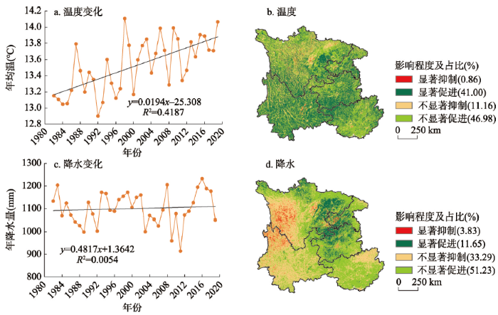
图4
1982—2019年西南地区温度和降水量变化趋势及对NDVI影响
Fig. 4
Trends and impacts of temperature and precipitation on the NDVI in Southwest China from 1982 to 2019
降水对NDVI产生促进作用的面积占62.88%,呈显著促进的面积11.65%,其集中分布于四川盆地及云贵高原东部,表明降水增加有利于这些地区植被的生长。降水对NDVI产生抑制作用的面积占37.12%,呈显著抑制的面积占3.83%,主要分布于横断山脉南部。总的来说,降水对NDVI的作用与温度不同,其体现出显著的空间差异,降水对西南地区东部主要起促进作用,对西部存在较强的抑制作用。
3.3 人类活动和气候变化对NDVI的影响
如图5所示,通过残差趋势分析,在像元尺度对人类活动与气候变化对NDVI变化的贡献进行量化。1982—2019年西南地区气候变化和人类活动共同促进了NDVI的增加,其中气候变化对NDVI增加的贡献约为0.0012 a−1,约占NDVI增长趋势的60.28%;人类活动对NDVI的贡献约为0.0008 a−1,约占NDVI增长趋势的39.72%。两种因素作用区域分离前气候变化与人类活动对NDVI增长的贡献分别为30.47%和69.53%,分离后人类活动对NDVI的贡献减少了29.81%,说明以往的研究对西南地区人类活动对植被变化的贡献存在高估而对气候变化的效用存在低估。
图5
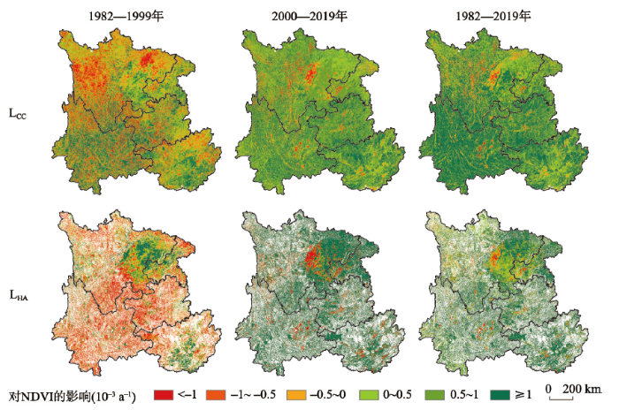
图5
1982—2019年西南地区气候变化和人类活动对NDVI的影响
Fig. 5
Impacts of climate change and human activities on the NDVI in Southwest China from 1982-2019
对比实施退耕还林工程前后时期气候变化和人类活动对NDVI的影响。自实施退耕还林工程后,人类活动对NDVI存在更多的积极影响;实施退耕还林工程前,除四川盆地以及广西南部农业区外,人类活动对NDVI的作用主要以消极影响为主。在实施退耕还林工程前后时期,相同的是农业区人类活动均对NDVI产生正面作用,其原因可能与化肥、灌溉、育种等农业生产技术的提升有关。自2000年以后,城市化进程加快,川渝城市群及各大城市周边地区人类活动对NDVI产生的消极影响要强于2000年之前,说明城市化对植被恢复存在消极影响。总的来说,实施退耕还林工程前,除农业区以外,西南大部分地区存在植被退化的迹象;实施退耕还林工程后,人类活动对植被的影响从消极转变为积极影响,在与气候变化的综合作用下共同促进了西南地区的植被恢复。
4 讨论
4.1 NDVI动态变化分析
本文采用一元线性趋势分析方法探究了西南地区实施退耕还林工程前后时期NDVI的时空动态。结果显示,1982—2019年西南地区NDVI整体呈上升趋势,但实施退耕还林工程前后时期植被动态变化存在较大差异。实施退耕还林工程前NDVI变化存在小幅下降趋势,但这种趋势并非是空间全局趋势,NDVI的变化存在显著的空间异质性。西南地区西部作为青藏高原的延伸区域,海拔高人口少,植被类型以草地为主,当地居民在实施退耕还林工程前以放牧为生[40],过度放牧导致了植被结构破坏[41],产生了严重的植被退化现象;相反在东部四川盆地及东南农业区,人口密集,植被覆盖度以增加趋势为主,这是由于21世纪前,中部城市群发展缓慢,而科学施肥、灌溉、育种、灭鼠和除虫等农耕技术的发展促进了NDVI的增长,抵消了一部分来自于过度放牧、造田及城市扩张对植被带来的负面影响。实施退耕还林工程后,除中心城市及周边地区外,各地NDVI均以增加趋势为主,减畜禁牧政策的逐步实施以及城市化的快速发展[42],表明城市扩张逐渐取代放牧成为限制西南地区植被恢复的关键因素[43]。
4.2 NDVI对气候变化的响应
气候变化是影响植被动态的一个关键因素[39,44 -45],深入了解气候变化与NDVI之间的响应机制对于预测植被动态和进行有效的生态恢复管理至关重要[46-47]。以往的研究表明,温度和降水是影响西南地区植被生长的最重要气候因素[40]。温度在促进植被光合作用、延长生长季及控制养分循环等方面存在重要作用,而降水能够为植被的物化反应提供必需的水分[48-49]。一般来说,NDVI的年际变化是缓慢的,原因是气候变化对植被生长的影响是长期过程[50],而人类活动也只能在有限的区域内改变植被动态,而大面积剧烈的植被变化可能是极端气候造成的结果[51],1999年、2006年和2011年西南地区均出现极端干旱情况,同期NDVI有不同程度的下降趋势[52]。
从长期来看温度和降水的变化对植被动态产生了积极影响,但不可否认,气候变化对植被动态的影响具有空间异质性,降水对不同区域内NDVI的影响的空间异质性更加明显。图4表明降水对西南地区东部植被存在显著促进作用,而对西部地区植被存在抑制作用,其主要原因是东部地区海拔较低,坡度平缓,温度高,蒸发量大,且土地类型以耕地(水田)为主,农作物以水稻和油菜作物为主,农作物对水分的需求量较大,植被生长主要受到降水的限制[53];而西部地区海拔较高,植被以高寒草甸为主,由于高寒草甸草根较短,地貌复杂,降水过多反而会造成水土流失,不利于植被生长[24,54]。温度在西南大部分地区表现出对植被活动的积极作用,适当的增温可以促进植物呼吸和光合活性,从而导致植被对温度变化产生积极响应[4]。需要指出的是,温度和降水与植被变化之间并非是一个简单的线性关系,海拔、地质、气候和植被类型都是影响因素[24]。干旱和半干旱地区,温度升高会增加蒸发量,从而阻碍植被的生长[55-56];但西南地区除西北横断山脉外均属于湿润和半湿润地区,温度升高不会影响水分供应,相反会促进光合作用[24];因此植被活动与温度存在明显的正相关,而横断山脉属于高寒山区,温度升高会促进高寒地区植被的生长[57]。
4.3 NDVI对人类活动的响应
中国政府实施退耕还林工程的目的主要是用于提高植被覆盖率、控制水土流失、增强区域碳汇等方面,了解退耕还林工程对植被恢复的作用需要评估其长期变化。图6表明,2003—2019年西南各省累计造林面积为249378.05 km2,年造林面积约为14669.30 km2,年造林面积约占研究区总面积的1.07%。Pearson相关分析显示累积造林面积与各省NDVI变化存在显著相关(P < 0.01),各省相关系数排名为:广西(0.946)>云南(0.930)>重庆(0.927)>贵州(0.900)>四川(0.841)。气候变化是西南地区植被变化的主要驱动力,但人类活动也发挥了重要作用,准确量化人类活动对植被的影响也非常重要。当考虑所有时间尺度及整体研究区时,植被变化主要是由气候变化驱动的, 而具有短期植被变化特征的区域一般由人类活动驱动[24]。自实施生态修复项目以来,1982—2019年中国森林面积增长约占国土面积的10%,西南地区石漠化土地面积减少了24790 km2,西南地区荒漠化进程已经放缓、停止甚至逆转[58],人类活动对植被演变的影响从消极作用转变为积极作用[59-60],表明退耕还林工程在改善环境质量和促进土地可持续发展方面发挥了重要作用[61]。农业区人类活动对植被影响的贡献显著高于气候变化,表明农耕技术决定了农业区植被的生长而非气候变化[38]。
图6
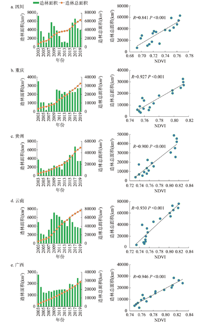
图6
2003—2019年西南各省造林面积与NDVI变化的关系
Fig. 6
Relationship between afforestation area and NDVI changes in different provinces in Southwest China from 2003 to 2019
以往的研究并不采用人类活动和气候变化影响区分离的方法,这使得人类活动对植被变化的影响研究一直存在高估。根据多时相土地利用数据将气候变化与人类活动影响区域进行分离,结果显示西南地区人类活动区域存在空间分异性,研究区约61.02%的植被受到人类活动和气候变化的综合影响,约38.98%的植被仅受气候变化的单一影响。未受人类干扰的地区主要分布在远离人类居住区的区域,如川西高原、山脉及森林地区,当去除掉这些地区的人为因素干扰后,人类活动对植被变化的贡献从69.53%下降至39.72%。两种因素分离前人类活动对植被变化的贡献要略高于金凯等[12]和Ma等[29](人类活动贡献均为65%)的研究结果,其原因在于研究区域与研究年限的差异,而分离后的人类活动对植被变化的贡献与Ge等[38](人类活动贡献为39.94%)的研究结果相似,表明研究结果具备可信性。一般来说,以往的研究认为人类活动对东部植被变化的贡献率更高,而对中西部植被变化的贡献率较低,人为因素促进了东部植被的恢复,而对中西部植被起破坏作用[62]。研究结果虽然表明了人类活动对植被变化的影响在不同地区存在差异,但均反映了人为因素对植被演变起到了重要作用。
4.4 研究的局限性
本文虽然基于8期土地利用数据对气候变化和人类活动影响的区域进行了分离,但仍存在一些问题。一方面,残差趋势分析忽略了气候变化与人类活动之间的复杂关系,将植被动态与影响因素之间的非线性关系转化为线性关系,这可能影响到研究结果的准确性。另一方面,人类活动的影响并不局限于改变土地的自然属性,例如,有限制性的放牧行为即使改变了植被覆盖度,但并未改变土地类型,这表示即使这个区域受到了人类活动的影响,我们也未将其看作人类活动影响区域的一部分,即使我们对草地覆盖度问题进行了分离(低、中、高覆盖草地的转换,被看作是人类活动的影响),但仍存在不确定性。另外,在大尺度研究中,不同区域植被对不同气候因子的响应程度存在差异,本文基于降水和温度与NDVI之间建立联系,可能会使局部区域研究结果产生一定的不确定性。
5 结论
本文基于融合GIMMS NDVI和SPOT NDVI生成的长时序高分辨率降尺度NDVI数据,结合气象数据和土地利用数据,采用一元线性回归趋势分析、偏相关分析和残差趋势分析等方法,探究了1982—2019年实施退耕还林工程前后时期西南地区气候变化和人类活动对NDVI动态的相对贡献。主要结论如下:
(1)1982—2019年西南地区NDVI呈显著上升趋势,年均增速为0.0020 a−1,但存在明显的时空差异。从时间变化上看,实施退耕还林工程前,NDVI存在小幅度的减少趋势;实施退耕还林工程后,NDVI以每年0.0052 a−1的趋势增加。从空间变化上看,NDVI增加的区域主要在农业区,减少的区域主要在各地的中心城市及周边地区。
(2)降水和温度对西南地区NDVI整体以促进作用为主,但降水对NDVI的作用存在明显的空间差异。相比于降水(62.88%),温度对NDVI产生促进作用的面积更高(87.98%),除中心城市外,温度对NDVI均存在促进作用;降水对西部地区植被存在抑制作用,而对东部地区植被以促进作用为主。
(3)气候变化和人类活动对西南地区NDVI变化的贡献存在明显的空间异质性,但两种因素对NDVI的影响均以促进作用为主。随着气候变化和人类活动的作用区域被分离,气候变化对NDVI变化的贡献从30.47%增加到60.28%,人类活动对NDVI变化的影响从69.53%减少至39.72%。实施退耕还林工程前,除农业区外,人类活动对NDVI的影响以抑制为主;实施退耕还林工程后,除城市周边地区外,人类活动对NDVI的影响以促进为主。
参考文献
Unprecedented Europe heat in June-July 2019: Risk in the historical and future context
Ecological perspectives of carbon neutrality
DOI:10.17521/cjpe.2021.0394
[本文引用: 1]

In this article, I first briefly introduce the concept of “Carbon Neutrality”, and then discuss the vital role of ecosystem carbon sinks in achieving the carbon neutrality target. It is assertive that any efforts to achieve the carbon neutrality target depend unavoidably on both reducing carbon emissions and enhancing carbon sequestrations. There are four key factors in reducing carbon emissions, including lowering energy consumption in human activities, restructuring fossil energy consumptions especially decreasing coal consumption, promoting energy use efficiency, and developing clean and low-carbon energy. Enhancing carbon sequestration relies inclusively on restoration, construction, and better management of the ecosystems. Benefited from enhanced vegetation growth and ecological engineering practice, Chinese terrestrial ecosystem has acted and will continue to act the significant role in the carbon sequestration. To improve the ecosystem carbon sequestration, I propose the “three-optimization principles”, i.e., optimal ecosystem arrangement, optimal species setting, and optimal ecosystem management. In addition, I also state some viewpoints on potential problems and challenges in the “post-carbon neutrality” era. It may be crucial to proactively and rationally think about the possibilities of declining global vegetation productivity and relevant new environmental issues caused by a decrease in the CO2 concentration rising in the era.
碳中和的生态学透视
DOI:10.17521/cjpe.2021.0394
[本文引用: 1]
在简述碳中和概念的基础上, 重点对碳中和的实现途径及生态系统碳汇的重要性进行了评述, 认为碳减排和碳增汇是实现“碳中和”的两个决定因素; 碳减排的核心是节能、调结构、增效和发展清洁能源, 碳增汇的核心是生态保护、建设和管理。由于植被自然生长和生态建设等因素, 中国陆地生态系统发挥了, 并将在未来继续发挥着重要的碳汇作用。为增强生态系统的固碳能力, 作者提出“三优”生态建设和管理原则, 即“最优的生态系统布局、最优的物种配置、最优的生态系统管理”。此外, 文章还对“后碳中和”时代可能出现的问题和挑战进行了展望, 认为碳中和后, 由于气候变化, 特别是大气CO<sub>2</sub>浓度增速减缓甚至下降等因素, 可能导致全球性的植被生产力下降, 对此可能带来的新的环境问题需要提前谋划和应对。
Characteristics, drivers and feedbacks of global greening
Environmental controls over carbon dioxide and water vapor exchange of terrestrial vegetation
DOI:10.1016/S0168-1923(02)00104-1 URL [本文引用: 1]
NDVI-based vegetation dynamics and their responses to climate change and human activities from 1982 to 2020: A case study in the Mu Us Sandy Land, China
The impacts of climate extremes on the terrestrial carbon cycle: A review
DOI:10.1007/s11430-018-9363-5 [本文引用: 1]
Rapidly declining surface and terrestrial water resources in Central Asia driven by socio-economic and climatic changes
Impacts of climate change and anthropogenic activities on vegetation change: Evidence from typical areas in China
Increased plant growth in the northern high latitudes from 1981 to 1991
DOI:10.1038/386698a0 [本文引用: 1]
Response of terrestrial ecosystems to recent Northern Hemispheric drought
Contribution of climatic change and human activities to vegetation NDVI change over China during 1982-2015
DOI:10.11821/dlxb202005006
[本文引用: 4]
Based on the observed daily temperature and precipitation of the land surface of 603 meteorological stations in China, the Global Inventory Modeling and Mapping Studies (GIMMS) Normalized Difference Vegetation Index (NDVI) 3rd generation dataset, the changing patterns of NDVI in China during 1982-2015 were investigated and the corresponding contributions of the main driving forces, climatic change and human activities, to these changes were distinguished using the methods of trend analysis and multiple regression residuals analysis. The results showed that vegetation recovered in whole China in research period significantly. Shanghai was the single case with a decrease in growing season NDVI in the selected 32 provincial-level administrative regions, while the growing season NDVI in Shanxi, Shaanxi, and Chongqing increased much faster compared with other regions. The climatic change and human activities drove the NDVI change jointly as main forces in China and induced both a rapid increasing trend on the whole and a huge spatial difference. The impacts of climatic change on NDVI change in the growing-season ranged from -0.01×10 -3 a -1 to 1.05×10 -3 a -1, while the impacts of human activities changed from -0.32×10 -3 a -1 to 1.77×10 -3 a -1. The contributions of climatic change and human activities accounted for 40% and 60%, respectively, to the increase of NDVI in China in the past 34 years. The regions where the contribution rates of human activities were more than 80% were mainly distributed in the central part of the Loess Plateau, the North China Plain, and the northeast and the southwest of China. There were 22 provincial-level regions where the contributions of human activities were more than 50%, and the shares of contribution induced by human activities in Shanghai, Heilongjiang, and Yunnan were much greater than those of any other regions. The results suggest that we should focus more on the role of human activities in vegetation restoration in the whole country.
1982—2015年中国气候变化和人类活动对植被NDVI变化的影响
DOI:10.11821/dlxb202005006
[本文引用: 4]
基于中国603个气象站的地表气温和降水观测资料以及GIMMS NDVI3g数据,采用变化趋势分析和多元回归残差分析等方法研究了1982—2015年中国植被NDVI变化特征及其主要驱动因素(即气候变化和人类活动)的相应贡献。结果表明:① 1982—2015年中国植被恢复明显,在选择的32个省级行政区中,山西、陕西和重庆的生长季NDVI增加最快,仅上海生长季NDVI呈减小趋势。② 气候变化和人类活动的共同作用是中国植被NDVI呈现整体快速增加和巨大空间差异的主要原因,其中气候变化对各省生长季NDVI变化的影响在-0.01×10 <sup>-3</sup>~1.05×10 <sup>-3</sup> a <sup>-1</sup>之间,而人类活动的影响在-0.32×10 <sup>-3</sup>~1.77×10 <sup>-3</sup> a <sup>-1</sup>之间。③ 气候变化和人类活动分别对中国近34年来植被NDVI的增加贡献了40%和60%;人类活动贡献率超过80%的区域主要集中在黄土高原中部、华北平原以及中国东北和西南等地;人类活动贡献率大于50%的省份有22个,其中贡献率最大的3个地区为上海、黑龙江和云南。研究结果建议应更加重视人类活动在植被恢复中的作用。
Interacting effects of temperature and precipitation on climatic sensitivity of spring vegetation green-up in arid mountains of China
Increasing sensitivity of alpine grasslands to climate variability along an elevational gradient on the Qinghai-Tibet Plateau
DOI:10.1016/j.scitotenv.2019.04.399 URL [本文引用: 1]
Temperature sensitivity as an explanation of the latitudinal pattern of green-up date trend in Northern Hemisphere vegetation during 1982-2008
DOI:10.1002/joc.4227 URL [本文引用: 1]
Moisture sources for precipitation in Southwest China in summer and the changes during the extreme droughts of 2006 and 2011
Spatial-temporal distribution and the influencing factors of mountain flood disaster in southwest China
DOI:10.11821/dlxb201907008
[本文引用: 1]
Studies on spatial-temporal characteristics and influencing factors of flash floods are key contents to the assessment and management of flash flood. Based on the historic flash flood data in southwest China from 1960 to 2015, the spatial and temporal distribution of flash flood and its influencing factors were analyzed by using the linear regression model, standard deviation ellipse, spatial autocorrelation, and logistic regression model. The results show that: (1) The annual frequency of flash floods in southwest China shows an exponential growth trend, and the annual variation reveals a stable, slow and rapid increase fluctuation during 1960-1980, 1981-1998 and 1999-2015, respectively; the monthly characteristics are obvious and precipitation is mainly concentrated in June, July and August. (2) The obvious spatial difference of flash flood is observed in the study area, and the high-density areas are mainly concentrated in central Yunnan plateau, Sichuan Basin and their surrounding mountainous areas. The flash flood distribution has a significant spatial positive correlation and spatial agglomeration (Moran's I index is 0.127, Z = 5.784, P = 0.007). (3) The gravity center of historical disasters has a distinct trend of moving to the west during the year. The standard deviation ellipse angle gradually weakens, the long axis gradually lengthens, and the short axis gradually shortens. (4) Rainfall factors have the maximum impact on flash floods, followed by human activity factors, and the minimal is surface environmental factors. Among the rainfall factors, the one-hour rainfall has the strongest impact on flash floods, and its dominant ratio reached 3.654. The results can provide techinical support for research on forming mechanism, monitoring and early warning, and implementation of disaster prevention and mitigation measures of flash floods.
西南地区山洪灾害时空分布特征及其影响因素
DOI:10.11821/dlxb201907008
[本文引用: 1]
山洪灾害时空特征和影响因素是山洪评估与管理的重要内容。根据1960-2015年中国西南地区历史山洪资料,采用线性回归、标准差椭圆、空间自相关和Logistic回归模型,深入分析了西南地区山洪灾害时空分布特征及其影响因素。结果表明:① 西南地区年度山洪灾害频次呈指数增长,年际变化呈现出稳定(1960-1980年)、缓慢波动增加(1981-1998年)、快速增加(1999-2015年)3个阶段;月际特征明显,山洪主要发生在每年6-8月,尤以7月频次最高;② 西南地区山洪灾害空间差异性显著,灾害高密度区主要集中于滇中高原地区、四川盆地和周边山地单元,山洪灾害数量分布呈显著的空间正相关,空间集聚特征明显(Moran's I指数为0.127、Z = 5.784、P = 0.007);③ 西南地区历史灾害点的重心在年内存在明显的向正西方向移动的趋势,年内标准差椭圆转角均逐渐弱化,长轴逐渐变长,短轴逐渐变短;④ 降雨因子对山洪的影响度最高,人类活动因子次之,地表环境因子最低,降雨因子中1 h降雨量对山洪的影响最强,优势比值达到3.654。研究结果可为西南地区山洪灾害形成机理、监测预警研究,实施防灾减灾措施等提供科技支撑。
Responses of landscape structure to the ecological restoration programs in the farming-pastoral ecotone of northern China
A long-term and comprehensive assessment of the urbanization-induced impacts on vegetation net primary productivity
DOI:10.1016/j.scitotenv.2019.02.361 URL [本文引用: 1]
Effects of ecological conservation projects and climate variations on vegetation changes in the source region of the Yangtze River
DOI:10.11821/dlxb201901006
[本文引用: 1]
Quantitative research on the effects of ecological conservation projects and climate variations on vegetation changes is vital to the ecological benefit evaluation of ecological conservation projects, and has important implications for sustainable ecological rehabilitation management strategies in the source region of the Yangtze River. Based on the normalized difference vegetation index (NDVI) data and meteorological data during 1982-2015, this paper examines the temporal and spatial variations of NDVI; constructs back propagation artificial neural network (BPANN) model to simulate the responses of NDVI to climate factors; and quantifies the effects of ecological conservation projects and climate variations on vegetation changes at the annual and seasonal scales in the source region of the Yangtze River. The results indicate that: (1) Because of the effects of ecological conservation projects and climate variations, vegetation degradation curbed in the source region of the Yangtze River. (2) NDVI increased greatly near the Tongtian River located at relatively low altitudes. Minor increases in NDVI were observed near the Tuotuo and Dangqu rivers located at relatively high altitudes. (3) A time lag (about 1-2 months) existed between NDVI and major climate factors in the source region of the Yangtze River. The goodness of fit of the BPANN model shows that the simulation accuracy is relatively high. The model can be used to simulate the responses of NDVI to climate variations. (4) Ecological conservation projects exerted a slightly greater impact on NDVI changes than they did on climate variations at the yearly time scale (58.5% and 41.5%, respectively). During growing season, ecological conservation projects also exerted a slightly greater impact on NDVI changes than they did on climate variations (63.3% and 36.7%, respectively). During non-growth season, climate variations are the key factor affecting vegetation growth in the source region of the Yangtze River (52.8%). The research results provide a basis for scientific decision-making about the vegetation ecosystem rehabilitation, management and utilization strategies in the source region of the Yangtze River.
生态保护工程和气候变化对长江源区植被变化的影响量化
DOI:10.11821/dlxb201901006
[本文引用: 1]
分析长江源区生态保护工程和气候变化对植被变化的影响程度,对于长江源区生态工程的生态效益评估,以及区域植被适应性生态管理政策的制定具有重要意义。因此,本文基于1982-2015年的归一化植被指数数据(Normalized Difference Vegetation Index, NDVI)和气象数据,分析长江源区植被NDVI的时空变化规律,构建预测植被NDVI对气候因子响应的人工神经网络模型,在此基础上,在年和季节尺度上量化气候变化和生态保护工程对长江源区植被变化的影响程度。结果表明:① 在长江源区气候条件变化和生态保护工程影响下,长江源区植被退化得到遏制,植被生长呈好转趋势;② 海拔相对较低的通天河附近植被NDVI增加幅度较大,高海拔的沱沱河和当曲流域的植被NDVI增加幅度相对较小;③ 长江源区植被NDVI对气候因子响应存在1~2月的滞后性。构建的人工神经网络模型的拟合优度参数人工神经网模型具有较高的预测精度,可以用来模拟植被NDVI对气候因子的响应;④ 年尺度的植被NDVI增加受到生态保护工程的影响程度(58.5%)大于气候变化的影响程度(41.5%)。生长季生态保护工程对NDVI的影响程度(63.3%)大于气候变化对NDVI的影响程度(36.7%),而非生长季气候变化是影响长江源区植被生长的关键要素(52.8%)。研究结果有助于为长江源区植被生态系统恢复、管理和利用战略的科学制定提供决策依据。
Loess Plateau: From degradation to restoration
Spatial simulation of "Grain to Green Program" implementation in a typical region based on agent-based model
DOI:10.11821/dlxb202009012
[本文引用: 1]
Landuse change is an essential driving force of global climate change. Dynamic simulations are helpful for understanding and explaining the changing rules and characteristics of the land system. The "Grain to Green Program" (GTGP) is a critical contributing factor to landuse change in China's mountainous areas. Presently, the deficiency of integrated social and spatial approaches in the simulation of the "GTGP" limits the spatial accuracy of the social benefits simulation and its subsequent research. The accurate simulation of the "GTGP", by combining social and spatial approaches, can provide scientific evidence for the completion of this project. Taking Tongdu Town, Dongchuan district in Yunnan province as the research area, this study identified three kinds of agents: farmers, farmer households, and the government based on census, geographical information and field survey data. In addition, this research constructed a regional spatial simulation of the "GTGP" implementation based on agent-based model. It conducted spatial simulations of Tongdu Town from 2011 to 2015, including the annual income of farmer households, the willingness of farmer households and the government towards the program, and the spatial processes implementation of the "GTGP". The results showed that the implementation of the "GTGP" was mainly related to the slope, the traffic, and the income of farmer households. Specifically, 81.47% of the "GTGP" program conducted in this areas was on slopes of 25°-30°, and 56.37% of them was 0-2 km away from the road with convenient traffic conditions, and the proportion of the "GTGP" areas with low annual income of farmers was relatively high. The correlation between "GTGP" areas and soil fertility was low. The implementation of the project significantly enhanced the revenue of the study area, with an average household income increase of 1475 yuan from 2010 to 2015. The spatial accuracy of the simulation results was 91.12%. The spatial simulation methods constructed in this study can provide references for the implementation of the "GTGP" in other regions, which can contribute to applications of ecological protection and targeted poverty alleviation programs in China.
基于多主体模型的典型区域退耕还林工程实施空间模拟
DOI:10.11821/dlxb202009012
[本文引用: 1]
土地利用变化是全球变化的重要驱动力,模拟是研究土地变化重要的方法。退耕还林是中国山区土地利用变化的重要原因。当前退耕还林模拟在综合社会与空间途径方面的不足限制了退耕还林模拟的空间精度及后续社会效益研究。结合社会和空间途径精确模拟退耕还林的空间过程可为该工程实施提供科学依据。本文以云南省东川区铜都镇为研究区,基于人口普查数据、地理环境数据、实地调研数据,综合考虑农民、农户和政府3类主体,基于多主体模型构建了退耕还林工程实施的空间模型,模拟了2010—2015年铜都镇具有空间特征的农户年收入、农户/政府退耕意愿和退耕还林工程空间实施过程。研究发现退耕还林工程实施主要与坡度、交通和农户收入有关,与土壤肥力相关性较小,坡度25°~30°的耕地占了81.47%,离道路0~2 km交通条件较好的地段占56.37%,农户年收入较低的区域退耕还林比例较高,且退耕还林工程的实施显著提高了铜都镇收入,2010—2015年户均收入提高了1475元。本文模拟结果空间精度为91.12%。本文构建的退耕还林工程实施空间模拟方法可为其它区域提供方法借鉴,以期为中国生态保护和精准扶贫等工程实施提供科学支撑。
Spatiotemporal patterns of soil protection effect of the Grain for Green Project in northern Shaanxi
DOI:10.11821/dlxb201909010
[本文引用: 1]
The study took northern Shaanxi, a key region of Grain for Green Project, as the research area. We firstly analyzed the spatiotemporal patterns of cropland during 2000-2013 using the remotely sensed time series cropland. The RUSLE model was improved by taking terraced fields as a parameter, and then the soil erosion modulus (SEM) was simulated using the calibrated model. Finally, the impacts of the Grain for Green Project on the soil erosion were assessed by comparing SEM changes in shifted and unshifted cropland. The results indicated that, the SEM across the areas of "Grain for Green" decreased by 22.70 t/hm 2 from 2000 to 2010, accounting for 47.08% of that from the returned cropland in 2000. In the same period, the SEM from the unreturned cropland decreased by 10.99 t/hm 2, accounting for 28.60% of that from the unreturned land in 2000. For the whole study area, the SEM of different land use types averagely decreased by 14.51 t/hm 2, which is 41.87% of the SEM in northern Shaanxi in 2000. We concluded that "Grain for Green" could effectively reduce the SEM in northern Shaanxi and made the most contribution to soil protection. The Grain for Green Project entered a consolidation period after 2000 (during 2010-2013 in this study), and changes of the SEM during this period were thus relatively low.
陕北地区退耕还林还草工程土壤保护效应的时空特征
DOI:10.11821/dlxb201909010
[本文引用: 1]
以中国退耕还林生态工程重点区域陕北地区作为研究区,基于耕地遥感监测数据集,分析了陕北地区2000-2013年耕地的时空变化特征;基于梯田空间分布,对RUSLE模型进行改进,模拟生成陕北地区土壤侵蚀模数栅格数据并进行精度验证;最后结合耕地变化数据集对陕北地区退耕还林(草)地及未退耕地的土壤侵蚀变化特征进行对比分析,以明确工程对全区土壤侵蚀变化的影响。结果表明,2000-2010年,陕北退耕农田内部侵蚀模数减少了22.70 t/hm <sup>2</sup>,是退耕农田区2000年土壤侵蚀模数的47.08%。同期,陕北地区未退耕农田侵蚀模数减少了10.99 t/hm <sup>2</sup>,占未退耕农田区域2000年土壤侵蚀模数的28.60%。从陕北全区的角度看,各种土地利用类型2000-2010年土壤侵蚀模数平均减少了14.51 t/hm <sup>2</sup>,占2000年全区土壤侵蚀模数的41.87%。由此可见,退耕还林还草工程可以有效减少土壤侵蚀模数,达到土壤保护的作用。其中,由耕地转为林草所导致的侵蚀减少最为显著,对土壤保护的贡献作用最大。但是,2010年以后(2010-2013年)为退耕还林还草巩固时期,因此该阶段陕北地区土壤侵蚀模数和土壤侵蚀量变化较前10年显著降低。
Relative importance of climate change and human activities for vegetation changes on China's silk road economic belt over multiple timescales
DOI:10.1016/j.catena.2019.04.027 URL [本文引用: 5]
Evaluation of the heterogeneity in the intensity of human interference on urbanized coastal ecosystems: Shenzhen (China) as a case study
Moving beyond the concept of "primary forest" as a metric of forest environment quality
DOI:10.1002/eap.1477 URL [本文引用: 1]
Large Chinese land carbon sink estimated from atmospheric carbon dioxide data
DOI:10.1038/s41586-020-2849-9 [本文引用: 1]
Geographical studies of Southwest China based on articles published in Acta Geographica Sinica from 1934 to 2018
DOI:10.11821/dlxb201911004
[本文引用: 1]
Regions continue to be one of the most logical and satisfactory ways of organizing the geographical information. Southwest China has always been concerned by geographers at home and abroad for its unique geographical phenomena. Its research vein could be looked into and given some useful suggestions for the future research through analyses of the articles published in Acta Geographica Sinica during 1934-2018. The results show that: (1) Articles about Southwest China covered almost all the subjects of geography, and the research results about geomorphology, meteorological climate, integrated physical geography, and ecological environment are the most widely published, while those on cities, ethnic groups, transportation and health are less concerned; (2) Up to 2018, the research had experienced four stages, early traditional regional research, task-led discipline, connecting the preceding and the following, and diversified development; (3) The periodical changes of the quantity and contents of these articles are influenced by the pattern of national affairs, and by the changes of the research paradigm of geography; (4) The articles published in Acta Geographica Sinica are of high research level, no matter from the academic perspective or the research methods, and many studies on regional nature, humanities, social economy and ecological environment are at the forefront of academic research, representing the academic research on geography of Southwest China; (5) However, the growth rate of articles about this region is far behind the increase in the number of articles in Acta Geographica Sinica, and the external research institutions and universities account for a large proportion of the number of articles, while the locals are weak. Compared with physical geography, there are fewer studies on human geography. As China's "island in the sky" and "cradle of ancient humans beings", Southwest China should be re-examined in the fields of the traditional and modern collision, boundary contact and conflict, and inter-regional contact and competition from the perspective of new regional geography, and continue to achieve the geographical significance of the study region.
基于《地理学报》创刊85年载文的中国西南地区之地理研究
DOI:10.11821/dlxb201911004
[本文引用: 1]
西南地区以其独特的地理现象一直为国内外地理学者所关注。通过对《地理学报》创刊以来85年间西南地区研究的载文分析,可以管窥其研究脉络,并予未来研究以启示。结果表明:① 232篇论文囊括了地理研究的若干主题,但以地貌、气象气候、综合自然地理和生态环境发文量最大,而城市、民族、交通、健康则关注较少;② 研究经历了传统区域研究、任务带学科、承上启下和多元化发展4个阶段;③ 论文在数量和内容上的阶段性变化,既受国家时事格局影响,也受地理学科研究范式发展变化影响;④ 《地理学报》有关西南地区的载文具有很高的研究水平,无论是在学术视野还是研究方法手段上,区域的自然、人文、社会经济与生态环境等诸多研究都站在了学术研究前沿,代表了学界对西南地理的研究情况;⑤ 但西南地理研究论文增长速度远赶不上《地理学报》载文量增长,外来研究机构占比很大,本土力量弱;相较自然地理,人文地理研究也少而弱。可见,西南地理研究当从新区域地理视角重新审视这一地区传统与现代的碰撞、边界的接触与冲突和区际的联系与竞争,继续成就西南地区重要的地理意义。
Quantitative assessment of the relative contributions of climate change and human activities to NPP changes in the Southwest Karst area of China
DOI:10.1007/s11356-022-21433-1 [本文引用: 2]
Spatial heterogeneity and its changes of population on the two sides of Hu Line
DOI:10.11821/dlxb201701012
[本文引用: 1]
Hu Line uncovers one of China's most important characteristics of population paper distribution: East is dense, while west is sparse. Different from most previous research, this paper examined the differentiation and changes of population distribution on both sides of Hu Line from a perspective of spatial stratified heterogeneity instead. Geodetector was employed based on the spatial database of China's census data of 1953, 1982, 1990, 2000 and 2010 to reconfirm spatial position of Hu Line and analyzed changes of spatial stratified heterogeneity of population between southeast and northwest sides of Hu Line in different periods. Changes of population distribution since the founding of New China were found and the reasons for these changes were discussed. Major findings include: (1) From the spatial stratified heterogeneity perspective, Hu Line could be improved and optimized, at least, in some periods. Although the ratio of total population on both sides of Hu Line has roughly been kept at 94:6 since 1953, spatial stratified heterogeneity of population between the two sides (the southeastern side: the northwestern side) increased when Hu Line moves to south slightly in 1953, 2000 and 2010, which means population distribution was more homogeneous within either southeastern or northwestern region and heterogeneity was more remarkable between the two regions. (2) Heterogeneity decreased gradually since the reform and opening up. We found characteristics of population distribution converged on the two sides, especially since the 1990s when convergence between the two sides became apparent. This finding is significantly different from the conclusion of "remain unchanged" from most literatures. The reasons why heterogeneity reduced were: pattern of population distribution on the southeastern side changed from relatively even distribution among cities before 1990 to agglomeration in a few huge cities after 2000, while the degree of spatial agglomeration of population decreased slightly after the reform on the northwestern side. These changes have been confirmed by the analysis from cumulative distribution function and Gini coefficient. (3) On the whole, the effect of economic factors on population distribution has become more and more important, while the effect of natural environment and institution reduced. Combined effect from economic development, natural environment and institution resulted in two opposite directions of changes of population spatial distribution on the two sides. It should be emphasized that although general effect of natural environment has decreased, some natural factors, such as Three Gradient Terrains, still have significantly influence on population distribution in China.
胡焕庸线两侧人口的空间分异性及其变化
DOI:10.11821/dlxb201701012
[本文引用: 1]
胡焕庸线作为人地关系的重要地理大发现之一,揭示了中国人口分布东密西疏的重要特征,是人文与经济地理学对社会的重要贡献之一。本文采用地理探测器等定量方法,以人口普查数据为基础,对胡焕庸线两侧人口分布的分异性特征进行了深入讨论,并尝试解释中国人口分布特征变化的原因及其机制。结果表明:① 胡焕庸线作为中国最重要的人口分界线仍基本保持稳定,但从空间统计学分异特征来看该分界线仍可进一步优化调整;② 胡焕庸线两侧内部人口集聚模式发生着明显变化,东南半壁人口分布由改革开放之前和初期的相对均衡状态,转变为以长三角、珠三角等少数区域为中心的集聚模式;而西北半壁人口分布的集聚程度则趋于下降;③ 从人口空间分布的影响因素看,尽管总体上,经济发展类因素对于人口空间分布影响不断增强,但三大阶梯等自然地理本底条件依然对中国人口分布有着重要影响。
1 km monthly temperature and precipitation dataset for China from 1901 to 2017
DOI:10.5194/essd-11-1931-2019 URL [本文引用: 1]
Remote sensing of vegetation and land-cover change in Arctic tundra ecosystems
DOI:10.1016/j.rse.2003.10.018 URL [本文引用: 1]
Spatial and temporal patterns of global NDVI trends: Correlations with climate and human factors
DOI:10.3390/rs71013233 URL [本文引用: 1]
Spatial-temporal changes of NPP and its relationship with climate change in karst areas of Yunnan, Guizhou and Guangxi from 2000 to 2019
2000—2019年滇黔桂岩溶区植被NPP时空变化及与气候变化的关系研究
DOI:10.16258/j.cnki.1674-5906.2021.12.002
[本文引用: 1]
滇黔桂岩溶区属于生态环境脆弱区,对其植被NPP(Net Primary Production)动态变化进行监测并探索其与气候变化的关系,对于研究区生态环境治理与保护具有重要意义。基于2000—2019年的MOD17A3 NPP数据,结合同期基于站点的气象数据,采用趋势分析、Mann-Kendall显著性检验、R/S分析及相关分析等方法,研究了滇黔桂岩溶区植被NPP的时空变化特征和未来趋势,并探讨了滇黔桂岩溶区植被NPP与气候变化之间的关系。研究结果表明:(1)2000—2019年滇黔桂岩溶区植被NPP均值为845.49 g∙m<sup>-2</sup>∙a<sup>-1</sup>(以C计),空间上呈现南高北低的分布格局,20 a间植被NPP总体呈现波动上升趋势,上升速度为4.02 g∙m<sup>-2</sup>∙a<sup>-1</sup>,呈上升趋势的面积占总面积的80.19%,其中呈显著上升的区域占46.60%;(2)研究区未来植被NPP以上升趋势为主,且未来同向变化趋势远大于反向变化趋势;(3)研究区气温对研究区植被NPP呈现显著促进作用,而降水、相对湿度和日照时数对研究区植被NPP无明显作用。气候变化对植被NPP的影响有明显的空间异质性,不同地带岩溶区植被NPP对气候变化的响应程度相差较大;(4)植被NPP对前0—1月气温和日照时数变化响应程度较高,而对前2—3月降水及相对湿度变化响应程度较高。
Assessment of rangeland degradation and development of a strategy for rehabilitation
DOI:10.1016/j.rse.2004.01.015 URL [本文引用: 1]
Quantitative contributions of climate change and human activities to vegetation changes over multiple time scales on the Loess Plateau
Quantifying the contributions of human activities and climate change to vegetation net primary productivity dynamics in China from 2001 to 2016
Spatiotemporal changes of NPP and natural factors in the southwestern karst areas from 2000 to 2019
近20年西南喀斯特地区植被NPP时空变化及自然因素地理探测
Spatialization method of grazing intensity and its application in Tibetan Plateau
DOI:10.11821/dlxb202203004
[本文引用: 2]
Spatialization of human activity intensity is the basis for examining regional differences of human activities and its change process, and it is also the scientific basis for accurately identifying the driving factors of land change and rationally regulating human activities. The current research on human activity intensity mostly uses mathematical methods to spatially assign indirect indicators, which lacks the reflection of the mechanism of human activity and also restricts the display of the spatial heterogeneity of human activity intensity. This paper took grazing activity on the Tibetan Plateau as the research object in an attempt to spatialize grazing intensity. First, based on grazing preferences and grassland management strategies, and from the perspective of grazing mechanism, we proposed a method to distinguish grazing areas and non-grazing areas; then, we used grazing density to measure the overall grazing pressure of grassland, and used grazing probability to describe the spatial difference of grazing pressure. In addition, we developed a spatial model of regional grazing intensity according to grazing density and grazing probability. As a case study, we used this model to spatialize grazing intensity of Zeku County, a typical pastoral area on the Tibetan Plateau, based on township-level animal husbandry data and basic physical geographic information. The results showed that the spatial model of grazing intensity we developed can reflect the spatial characteristics of grazing activity well, and the selection of direct indicators and objective assignment methods improve the accuracy of the spatialization results. It is also found that the results of this paper can more clearly reflected the spatial difference of grazing intensity within the county than the previous research results, and the change process of grazing intensity had a better coupling with the change of NDVI value over the same period. This paper could provide a useful reference for the research on spatialization methods of human activities.
青藏高原放牧强度空间化方法与应用
DOI:10.11821/dlxb202203004
[本文引用: 2]
人类活动强度空间化是分析人类活动区域差异及其变化过程的基础,也是准确辨识土地变化驱动因素、合理调控人类活动的科学依据。当前人类活动强度研究多以数理方法对代用指标进行空间化,缺乏对人类活动机理过程的反映,也制约了人类活动强度空间异质性的展现。本文以青藏高原放牧活动为研究对象,在综合放牧喜好和草地管理策略的基础上,从放牧行为机理的角度,提出了区分放牧区与非放牧区的方法;以放牧密度衡量草地整体放牧压力,以放牧概率刻画放牧活动的空间差异,构建了区域放牧强度空间化模型。并以高原典型牧业县—泽库县为例,基于乡镇级牧业数据和自然地理基础信息进行了实证研究。结果表明:空间化结果较好反映了泽库县放牧强度的空间特征;直接指标的选取和客观的赋值方法提高了放牧强度空间化结果的准确性;比现有研究结果更能体现出县域内放牧强度的空间差异,且放牧强度变化过程与同期NDVI值变化具有较好的耦合性。本文为人类活动空间化方法研究提供了有益参考。
Effectiveness of grazing exclusion on the restoration of degraded alpine grasslands on the Northern Tibetan Plateau from 2010 to 2017
2010—2017年藏北高寒退化草地禁牧恢复效果评价
Role of monitoring in environmental regulation: An empirical analysis of grazing restrictions in pastoral China
Assessment of NDVI variations in responses to climate change in the Horn of Africa
DOI:10.1016/j.ejrs.2020.08.003 URL [本文引用: 1]
Greening of the Earth and its drivers
DOI:10.1038/NCLIMATE3004
[本文引用: 1]
Global environmental change is rapidly altering the dynamics of terrestrial vegetation, with consequences for the functioning of the Earth system and provision of ecosystem services(1,2). Yet how global vegetation is responding to the changing environment is not well established. Here we use three long-term satellite leaf area index (LAI) records and ten global ecosystem models to investigate four key drivers of LAI trends during 1982-2009. We show a persistent and widespread increase of growing season integrated LAI (greening) over 25% to 50% of the global vegetated area, whereas less than 4% of the globe shows decreasing LAI (browning). Factorial simulations with multiple global ecosystem models suggest that CO2 fertilization effects explain 70% of the observed greening trend, followed by nitrogen deposition (9%), climate change (8%) and land cover change (LCC) (4%). CO2 fertilization effects explain most of the greening trends in the tropics, whereas climate change resulted in greening of the high latitudes and the Tibetan Plateau. LCC contributed most to the regional greening observed in southeast China and the eastern United States. The regional effects of unexplained factors suggest that the next generation of ecosystem models will need to explore the impacts of forest demography, differences in regional management intensities for cropland and pastures, and other emerging productivity constraints such as phosphorus availability.
NDVI-based vegetation dynamics and their responses to climate change and human activities from 1982 to 2020: A case study in the Mu Us Sandy Land, China
Distinguishing the vegetation dynamics induced by anthropogenic factors using vegetation optical depth and AVHRR NDVI: A cross-border study on the Mongolian Plateau
Detection and attribution of vegetation greening trend across distinct local landscapes under China's Grain to Green Program: A case study in Shaanxi Province
NDVI-based analysis on the influence of climate change and human activities on vegetation restoration in the Shaanxi-Gansu-Ningxia Region, Central China
DOI:10.3390/rs70911163 URL [本文引用: 1]
Time lag of vegetation growth on the Loess Plateau in response to climate factors: Estimation, distribution, and influence
along the Silk Road Economic Belt
Moisture sources for precipitation in Southwest China in summer and the changes during the extreme droughts of 2006 and 2011
Spatial and temporal effects of drought on Chinese vegetation under different coverage levels
Assessing vegetation dynamics impacted by climate change in the southwestern karst region of China with AVHRR NDVI and AVHRR NPP time-series
DOI:10.1007/s00254-007-0901-9 URL [本文引用: 1]
Observational quantification of climatic and human influences on vegetation greening in China
Variation of net primary production and its correlation with climate change and anthropogenic activities over the Tibetan Plateau
Grasslands in the Tibetan Plateau are claimed to be sensitive and vulnerable to climate change and anthropogenic activities. Quantifying the impacts of climate change and anthropogenic activities on grassland growth is an essential step for developing sustainable grassland ecosystem management strategies under the background of climate change and increasing anthropogenic activities occurring in the plateau. Net primary productivity (NPP) is one of the key components in the carbon cycle of terrestrial ecosystems, and can serve an important role in the assessment of vegetation growth. In this study, a modified Carnegie–Ames–Stanford Approach (CASA) model, which considers remote sensing information for the estimation of the water stress coefficient and time-lag effects of climatic factors on NPP simulation, was applied to simulate NPP in the Tibetan Plateau from 2001 to 2015. Then, the spatiotemporal variations of NPP and its correlation with climatic factors and anthropogenic activities were analyzed. The results showed that the mean values of NPP were 0.18 kg∙C∙m−2∙a−1 and 0.16 kg∙C∙m−2∙a−1 for the original CASA model and modified CASA model, respectively. The modified CASA model performed well in estimating NPP compared with field-observed data, with root mean square error (RMSE) and mean absolute error (MAE) of 0.13 kg∙C∙m−2∙a−1 and 0.10 kg∙C∙m−2∙a−1, respectively. Relative RMSE and MAE decreased by 45.8% and 44.4%, respectively, compared to the original CASA model. The variation of NPP showed gradients decreasing from southeast to northwest spatially, and displayed an overall decreasing trend for the study area temporally, with a mean value of −0.02 × 10⁻² kg∙C∙m−2∙a−1 due to climate change and increasing anthropogenic activities (i.e., land use and land cover change). Generally, 54% and 89% of the total pixels displayed a negative relationship between NPP and mean annual temperature, as well as annual cumulative precipitation, respectively, with average values of –0.0003 (kg∙C∙m−2 a−1)/°C and −0.254 (g∙C∙m−2∙a−1)/mm for mean annual temperature and annual cumulative precipitation, respectively. Additionally, about 68% of the total pixels displayed a positive relationship between annual cumulative solar radiation and NPP, with a mean value of 0.038 (g∙C∙m−2·a−1)/(MJ m−2). Anthropogenic activities had a negative effect on NPP variation, and it was larger than that of climate change, implying that human intervention plays a critical role in mitigating the degenerating ecosystem. In terms of human intervention, ecological destruction has a significantly negative effect on the NPP trend, and the absolute value was larger than that of ecological restoration, which has a significantly positive effect on NPP the trend. Our results indicate that ecological destruction should be paid more attention, and ecological restoration should be conducted to mitigate the overall decreasing trend of NPP in the plateau.
Responses of net primary productivity to phenological dynamics in the Tibetan Plateau, China
DOI:10.1016/j.agrformet.2016.08.020 URL [本文引用: 1]
Assessment of ecological benefits of key national ecological projects in China in 2000-2019 using remote sensing
DOI:10.11821/dlxb202209001
[本文引用: 1]
We propose a theoretical framework for assessing the ecological benefits provided by national key ecological projects in China over the past 20 years. A dataset consisting of six primary indicators and nine secondary indicators of ecosystem structure, ecosystem quality, and ecosystem services for the period 2000-2019 was generated using ground survey and remote sensing data. Ecological benefits were quantitatively evaluated following the implementation of national key ecological projects in China. Areas with medium, relatively high, and high degrees of ecological restoration accounted for 24.1%, 11.9%, and 1.7% of the national land area, respectively. Degrees of ecological restoration were higher in areas with a greater number of ecological projects. Areas with relatively high and high degrees of ecological restoration were mainly concentrated in the Loess Plateau, the farming-pastoral zone of northern China, the Northeast China Plain, and an area spanning the border areas of Sichuan, Yunnan, Guizhou, Chongqing, and Hunan. The relative contributions of climatic factors and ecological projects to changes in vegetation net primary productivity were 85.4% and 14.6%, respectively, and the relative contributions of climatic factors and ecological projects to changes in water erosion modulus were 69.5% and 30.5%, respectively. The restoration potential of national vegetation coverage was 20%, and the restoration potential percentages of forest and grassland vegetation coverage were 6.4% and 23%, respectively. Climatic conditions can inhibit ecological restoration. Areas with relatively high and high degrees of ecological restoration were mainly distributed in areas with an annual average temperature greater than 0 ℃ and annual precipitation greater than 300 mm. Therefore, the limitations associated with climate conditions should be considered during the implementation of national ecological projects. The implementation of single ecological projects or single ecological restoration measures should be avoided, the use of combined measures should be emphasized, and the benefits of ecological investment funds should be maximized.
2000—2019年中国重大生态工程生态效益遥感评估
DOI:10.11821/dlxb202209001
[本文引用: 1]
本文提出了重大生态工程实施生态效益评估理论框架,在选取生态系统宏观结构、生态系统质量和生态系统服务3大类、6个一级指标和9个二级指标的基础上,利用地面和遥感数据,结合模型模拟,生成了2000—2019年长时间序列评估指标参数数据集,定量评估了中国重大生态工程实施20年后的生态效益。结果表明:生态恢复程度中等、较高和高的区域面积分别占全国国土面积的24.1%、11.9%和1.7%,生态工程实施数量越多的地区,生态恢复程度越高,生态恢复程度较高和高的区域主要集中在黄土高原、北方农牧交错带、东北平原、川滇黔渝湘结合部等地区;气候因素和生态工程对植被净初级生产力变化的贡献率分别为85.4%和14.6%,对水蚀模数变化的贡献率分别为69.5%和30.5%;中国植被覆盖度有20%的恢复潜力,森林植被覆盖度恢复潜力为6.4%,草地植被覆盖度恢复潜力为23%;气候条件是生态恢复的重要限制因素,生态恢复程度较高和高的区域主要分布在年均温大于0 ℃和年降水量大于300 mm的地区。因此,重大生态工程的部署,应充分考虑气候条件的限制性,避免实施单一生态工程或单一生态恢复措施,充分发挥生态工程组合措施的综合效应,提高生态投入资金的最大效益。
Socio-ecological changes on the Loess Plateau of China after Grain to Green Program
DOI:10.1016/j.scitotenv.2019.05.022 URL [本文引用: 1]
Ecoloqical changes and the tradeoff and synergy of ecosystem services in western China
DOI:10.11821/dlxb202201013
[本文引用: 1]
Since the implementation of the government initiative-the Development of Western Regions for 2000-2019, a series of major ecological construction projects have been launched, leading to great changes in the ecological conditions and ecological services of western China. This study calculated the amount of total ecosystem services in the western region from 2000 to 2019, and analyzed ecological changes and the characteristics of spatio-temporal variations in ecological services. And a relevant analysis method was applied to explore the trade-offs and synergy of service. It was found that the area of settlements and wetland ecosystems in the study area increased significantly from 2000 to 2015, whereas grassland showed a downward trend year by year. The vegetation fraction showed a decreasing zonal distribution from south to north. A fluctuating increase was observed during 2000-2019, with inter-annual and large spatial differences. The water conservation service had a slight downward trend from 2000 to 2019, and the main decreasing areas were distributed in southeastern Tibet, the western part of the Three Rivers Source Region, and the karst rocky desertification area. The soil conservation service showed an increasing but fluctuating trend, with the greatest increases observed in the Loess Plateau, western Sichuan and Yunnan provinces, northwest Tibet, and southeast Tibet. The windbreak and sand fixation showed a downward trend, and the sharp decline was mainly found in the central and western parts of Inner Mongolia, Tibet and parts of northern Xinjiang. Ecosystem supply, water conservation, and soil conservation were synergistically connected, they were observed north of the Huaihe River-Qinling Mountains, especially in Ningxia and Inner Mongolia. Ecosystem supply was mainly trade-offs with windbreak and sand fixation, and it was observed in the farming-pastoral transitional zone. The synergistic degree of ecosystem services in areas subjected to ecological engineering policy was greater than that in non-engineering areas. Quantitative assessment of ecosystem service changes and their trade-offs is helpful for scientific ecological management and maximizing ecological benefits.
西部地区生态状况变化及生态系统服务权衡与协同
DOI:10.11821/dlxb202201013
[本文引用: 1]
西部大开发战略实施20年以来,一系列重大生态建设工程使得西部地区的生态状况和生态服务发生了重要变化,本文分析西部地区生态状况变化及其生态服务时空变化特征,并运用相关分析法研究其服务功能权衡协同关系。研究发现西部地区2000—2019年间:① 聚落和湿地生态系统面积显著增加,草地有逐年下降趋势。② 植被覆盖度呈波动上升趋势,存在年际差异且空间差异较大。③ 水源涵养服务有轻微下降趋势,下降区域主要分布在藏东南地区、三江源西部地区、喀斯特石漠化地区等;土壤保持服务波动中呈上升趋势,上升区域主要黄土高原地区、川滇西部地区、藏西北地区、藏东南地区等;防风固沙服务呈下降趋势,大幅下降区域主要位于内蒙古中西部地区、西藏和北疆部分地区。④ 生态系统供给与水源涵养、土壤保持主要为协同关系,与防风固沙主要为权衡关系且分布在农牧交错带地区。⑤ 生态工程区内生态系统服务协同程度大于非工程区。定量评估生态系统服务变化及其权衡协同关系有助于进行科学化生态管理,最大化生态效益。
The spatial-temporal changes of vegetation restoration on Loess Plateau in Shaanxi-Gansu-Ningxia region
DOI:10.11821/xb201207009
[本文引用: 1]
The "Grain for Green Project" initiated by the governments since 1999 were the dominant contributors to the vegetation restoration in the agro-pastoral transitional zone of northern China. Climate change and human activities are responsible for the improvement and degradation to a certain degree. In order to monitor the vegetation variations and clarify the causes of rehabilitation in Shaanxi-Gansu-Ningxia Region, this paper, based on the MODIS-NDVI and climate data during the period 2000-2009, analyzes the main characteristics, temporal-spatial distribution and reasons of vegetation restoration, using methods of linear regression, the Hurst index, standard deviation and other methods. Results are shown as follows. (1) From 2000 to 2009, the NDVI of the study area was improved progressively, with a linear tendency being 0.032/10a, faster than the growth of the Three-North Shelter Forest Program (0.007/10a) from 1982 to 2006. (2) The vegetation restoration is characterized by two fast-growing periods, with an "S-shaped" increasing curve. (3) The largest proportion of the contribution to vegetation restoration was observed in the significantly improved area, followed by the slightly improved area and the significantly degraded area, the last of which is distributed sporadically over southern Ningxia as well as Huanxian, Zhengyuan and eastern Dingbian of Gansu. (4) Climate change and human activities are the two driving forces in vegetation restoration; moreover anthropogenic factors such as "Grain for Green Project" were the main causes leading to an increasing trend of NDVI on local scale. However, its influencing mechanism remains to be further investigated. (5) The Hurst index of NDVI time series shows that the vegetation restoration was sustainable. It is expected that improvement in vegetation cover will expand to the most parts of the region.
近10年陕甘宁黄土高原区植被覆盖时空变化特征
Spatial-temporal variation of the vegetation coverage in Qinling Mountains and its dual response to climate change and human activities
DOI:10.11849/zrzyxb.20170139
[本文引用: 1]
The Qinling Mountains, a key ecological zone of terrestrial ecosystem, has experienced a significant change of vegetation coverage in recent years. Based on MODIS-<em>NDVI</em> data, DEM data and meteorological data such as temperature, precipitation, sunshine, humidity and wind speed, this paper calculated the Fractional Vegetation Coverage (<em>FVC</em>) in Qinling Mountains, analyzed the background characteristics of the “pattern-process-trend” change, and explored the dual response mechanism of the vegetation coverage to climate change and human activities with trend analysis method, multiple regression method-residual method and PLS regression method. The results of the study showed that: First, the <em>FVC</em> in Qinling Mountains showed a significant increase trend at a growth rate of 2.77%/10 a during 2000-2015, with a very significant upward trend in the southern slope at a growth rate of 3.8%/10 a and a non-significant downward trend in the northern slope. In the space, <em>FVC</em> showed the pattern that is “high in the middle, low in the surroundings; high in the west, low in the east; high in the south-slope, low in the north-slope”. Second, the level of <em>FVC</em> in Qinling Mountains varied greatly, and the order of each <em>FVC</em> grade in area was Ⅴ, Ⅳ, Ⅲ, Ⅱ and Ⅰ, the area of Ⅰ and Ⅴ showing significant upward trend while the area of others showing decline trend. Third, the change of <em>FVC</em> at different altitudes was significantly different. There was a significant upward trend under 1 500 m and obvious downward trend at 2 600 m, while there was no obvious change at 1 500-2 600 m. With the increase of altitude, the <em>FVC</em> reached a maximum at 2 200 m. The <em>FVC</em> at 700-3 200 m was more than 0.7 and at 1 300-2 700 m was more than 0.9, and values below 0.5 mainly appeared in high altitude area above 3 400 m. Forth, there were significant spatial differences in the response of vegetation coverage to climatic factors. The response of vegetation coverage to precipitation had time lag, with a lag of one month, while the response to temperature did not have time lag. Fifth, the role of human activities was increasing rapidly, with the growth rate of 2.10%/10 a. The positive effect of human activities on <em>FVC</em> mainly distributed in the eastern region, and the negative effect of human activities mainly distributed in the central and western regions. Finally, the <em>FVC</em> changes were the results of both climate change and human activities, and the impact factors from strong to weak are human activity, precipitation, temperature and potential evapotranspiration.
秦岭植被覆盖时空变化及其对气候变化与人类活动的双重响应
DOI:10.11849/zrzyxb.20170139
[本文引用: 1]
论文基于MODIS-NDVI数据、DEM及气象数据,辅以趋势分析、多元回归残差法、偏最小二乘回归法,反演了秦岭地区2000—2015年植被覆盖度及分析了其“格局—过程—趋势”的变化特征,探究了其对气候变化与人类活动的双重响应机制。结果表明:1)秦岭地区近16 a来植被覆盖度呈显著上升趋势,增速为2.77%/10 a,呈“中间高、周边低,西部高、东部低,南坡高、北坡低”的空间格局,植被覆盖度随海拔的升高在2 200 m左右达到最大,700~3 200 m达0.7以上,1 300~2 700 m达0.9以上,3 400 m以上为0.5以下的低值区;2)秦岭地区的植被覆盖与气候因子的响应关系存在明显的空间差异,对气温的响应总体上没有明显的时滞效应,而与降水的响应存在以滞后1个月为主的时滞效应;3)人类活动对秦岭地区植被变化的作用日趋增强,且以正向作用为主,主要分布在东部地区,而负向作用则分布于中部和西部地区;4)秦岭地区植被变化是气候变化和人类活动共同作用的结果,影响因子对植被覆盖变化的解释能力依次为人类活动>降水>气温>潜在蒸散量。
