

1 引言
土地利用作为人类与环境相互作用的核心环节,其空间形态和功能格局的演化及转型过程是对社会经济动态和生态系统变化的综合反映,土地利用问题也因此成为全球环境变化和可持续发展的重要研究议题之一。其中,耕地、园地、生产性林草地等直接或间接为农业生产利用的土地类型事关大食物安全、农户生计、农业农村发展与经济社会稳定,其重要性不言而喻。当前城乡建设、农业结构调整引起的农地资源快速消耗[1],农村人口流失和农业经济竞争力下降带来的农地边际化[2],以及工业污染转移和化肥农药不合理施用造成的农地生态系统退化等现象仍在继续[3]。如何把握农地变化机理,继而改进农地资源管理模式、实现农业要素配置合理化,农地利用转型研究具有重要的理论价值和现实意义。
农地利用转型是土地利用转型研究的重要内容,同样强调区域农地利用形态沿着“社会—生态负反馈”和“社会—经济动态”两条驱动路径[4],在长期变化过程中的趋势性转折[5]。与其他土地利用类型相似,位置固定性也决定了直接的农地利用活动总是发生在特定的地点。然而,随着区域连通性、人类可移动性和资源流动性不断增强,跨越空间距离的人地系统相互作用已十分普遍[6],影响农地利用决策和行为的众多因素并不局限于本地。城镇化持续推进背景下,居民消费结构快速升级,城乡要素流动愈发频繁,产业链、供应链将城市需求市场和乡村供给系统紧紧维系在一起,近远程的城乡居民膳食结构转型和对农业景观休闲功能的市场需求成为农地转型的新动因。因此,超越固定区位视角的传统研究范式,采用新的理论工具来透视需求驱动下的农地利用转型机制及土地系统的“遥相关” ( “遥相关”(Teleconnections)最早是大气科学中用来描述远距离气候系统相互作用的概念,后被Seto等引入土地系统科学,提出城市土地遥相关的概念框架,明确将乡村地区的土地利用变化与密切相关的城市化过程联系起来,重建了地点之间特别是城市功能与农村土地用途之间的远程联系[7]。)机理便十分重要。尽管学术界已意识到土地变化的遥相关机理意义重大[5,7 -8],但目前该方向的研究仍十分薄弱,现有研究只是针对“遥相关”或远程耦合视角下的土地利用转型研究进行了方向性的倡导,而尚未进行系统化的理论建构。
为此,本文在总结农地利用转型研究进展、揭示土地系统“遥相关”研究不足的基础上,尝试以食物系统纽带为切入点,将近远程耦合理论框架[9]与农地利用转型研究相结合,围绕理论创新科学基础、城市食物系统全程耦合下农地利用转型研究的分析框架与主要内容等方面开展理论研究,目的是推动全程耦合理论框架在食物系统和农地利用转型领域的应用,拓展土地利用转型领域的研究边界,并为解决新时代的“三农”问题提供理论参考。
2 农地利用转型研究进展述评
2.1 农地利用转型研究的主要进展
农地利用转型是土地利用转型的重要组成部分。土地利用转型概念源于“森林转型”(Forest Transition)假说[10-11]和国家土地利用形态(National Land Use Morphology)变化的研究[12],是指在经济社会发展与革新驱动下,区域土地利用变化沿特定路径持续演进后土地利用形态的趋势性转折[5,13]。自土地利用转型概念提出以来,国外有关农地利用转型的研究侧重于探讨农地利用转型对生态环境[14]、农户生计[15]、减贫与福祉[16]的影响以及农地利用转型驱动力[17]、农地废弃及其对农村社区、传统景观、生物多样性和生态系统服务的影响[18],尤其注重研究农地利用转型对鸟类、昆虫、植被等生物多样性的影响[19]。由于议题交叉性和案例背景的复杂性,国外农地利用转型研究具有较为鲜明的跨学科特点,主要涉及东欧转轨国家农地利用转型的跨学科研究、农田保护计划中的种族平等、以及不同经济、政策和文化背景下农地利用转型的环境风险[20]等。国内方面,随着土地利用转型领域的快速发展,针对农用地显隐性形态变化的研究和包含农用地的国土空间全地类要素转型研究不断增多,从理论构建、研究框架制定、假说检验到转型特征和转型机制的区域证实,农地利用转型的研究体系日趋完善。
从理论层面来看,耕地转型与土地整理研究框架[21]、耕地转型诊断和调控研究框架[22]、耕地利用功能转型综合解释框架[23]以及耕地利用隐性形态转型研究的多学科综合研究框架[24]相继提出;沿着“社会—生态负反馈”驱动的功能形态转型路径和“社会—经济动态”驱动的空间形态转型路径被明确建立起来[22];对诱致性生产替代作用下的耕地利用功能转型过程[23]以及中国山区以农用地为主的农村土地利用转型内涵、转型特征、转型驱动机理及转型效应等开展了深入的理论研究[25]。假说检验方面,利用国家林业局、国土资源部及相关文献数据[26]验证了中国的“森林转型”发生于1980年前后,且“森林转型”与耕地转型具有时间上的对应关系[2];有关农地利用变化假说及相关环境效应命题的综述则为农地利用转型研究提供了更加丰富的理论依据[27]。此外,耕地非农化的库兹涅茨曲线假说[28-29]、罗杰斯蒂曲线假说[30]以及经济增长与耕地占用的脱钩关系[31-32]等耕地转型规律假说得到了验证。
从转型特征来看,随着城镇化的快速推进,农地的数量配比和空间配置受到强烈扰动。总体而言,中国自1978年以来的耕地转型经历了从缓慢转型、快速转型到平稳转型和创新转型的多个阶段[33];其中,2000—2008年的土地利用年度变更调查数据显示,中国耕地面积与农村宅基地面积之间呈现出增减逆协同的演进格局[34]。相关研究以面积、结构、布局为表征,证实了人均耕地面积从逐渐下降到保持稳定甚至恢复增长的变化过程[35],耕地种植结构由粮食作物向经济作物、园艺作物调整的过程也从加速到趋缓[36],建设用地蚕食下的农地斑块破碎化趋势使得乡村景观连续性受损[37⇓-39]。隐性形态上,农地投入产出效率和功能形态变化是主要切入点,学者们多从粮食安全、社会保障、经济贡献、生态维护等多个维度评价耕地功能变化[40-41],从劳动力、机械、农药、化肥等农业生产要素的投入情况来度量农地利用强度[42-43]以及农户耕地利用效率在不同地貌类型区及农户类型上的差异[44]。生态文明建设和绿色发展理念不断深化背景下,碳排放[45-46]、绿色利用效率[47]、生态系统服务[48]等指标测算也纳入了农地利用隐性形态的刻画中。
从转型机理来看,农地利用转型影响因素和驱动机制的研究成果颇丰,涵盖了自然、社会、经济、制度等多个层面。其中,高程、坡度、距离等被认为是影响农地利用形态的主要自然环境因素[49⇓-51]。社会经济层面主要探讨城乡转型发展对农地利用转型的耦合关系[3],对人口城乡迁移[52]、城市扩张[53]、劳动力要素变动[54]、农户生计策略变化和生计资本配置[55-56]等人文因素的分析居于主要地位;认为人口城乡迁移本质上是非农工资上涨导致务农机会成本上升背景下农村劳动力的再配置过程,并进一步引发对农用地的再配置,从而形成农用地“低端边际化”或“高端边际化”等不同情景的农地利用转型[57]。制度与政策层面,退耕还林工程[58]、“菜篮子”工程[59]、土地配额交易制度[60]对农地生态系统服务价值提升、设施农用地扩张和耕地保护的作用得到初步探索;土地流转获取增值收益的土地资本化过程和企业导向的土地整理模式也是农村经济空间由分散走向集中的重要因素[61-62]。此外,有不少研究论述了农地利用转型对鸟类等生态群[63]、农村经济增长[64]以及粮食产量[65]的影响和耦合作用。
总之,目前有关农地利用转型的大量研究成果对于理解农地利用形态变化的趋势性转折,以及揭示“社会—生态反馈”和“社会—经济动态”的作用路径与机理提供了良好的洞察力,但农地利用转型研究仍存在一些不足:① 现有研究主要关注耕地利用转型,对园地、牧草地、养殖水域等其他农用地类型关注较少;② 由于相关数据缺失、长期动态监测及社会调查难度大,隐性形态研究难以深入[66],相较于国外,生物多样性等特定视角下的农地利用转型机制和效应研究十分有限,还需进一步加强;③ 在农地利用转型机制的需求驱动及土地系统“遥相关”方面存在明显空白,尤其食物系统全程耦合下的农地利用转型鲜有研究涉及。
为填补上述空白,农地利用转型研究亟需将“流空间”②( ② “流空间”(Space of Flows)是社会学家Manuel Castells在《信息化社会》中提出的概念,是指通过时间控制促使信息流动及物质流动的一种社会组织形式。在地理学中,“流空间”引申为以信息流负载各要素流为主要运作方式的交互性网络化空间。)与地点空间整合起来,引入能够整合“流空间”与地点空间的全程耦合框架,进行空间维度的系统集成,以更加深入、有效地解析和调控农地利用转型。
2.2 农地利用转型研究亟需引入全程耦合视角
从乡土社会阶段“区域人口增长—耕地扩张—林草地收缩”到城乡社会阶段的“人口城乡迁移—生产要素重组—种植结构调整/耕地弃耕撂荒—林草地持续收缩后保持稳定以至恢复增长”,农地利用转型不仅折射出人类社会发展进程中人地关系的深刻演变,也蕴含着近今城乡关系的嬗变与转型。
从人地关系的演变趋势来看,工业革命以来,随着交通通信技术不断革新,以及区域联通水平和要素流动性不断增强,人类空前拓展了自身活动及其影响的空间范围[6]。在全球化和城市化共同驱动下,上述背景因素与地域功能分化、生产要素优化配置和交通网络快速扩展交互影响[9],地区性及全球生产网络不断寻求契机促进跨边界合作[67-68]。以供应链/价值链为依托、以要素流为载体、体现于土地上的人类—环境相互作用逐渐跨越了文化、社会治理与生态系统的边界[69],形成跨越空间距离的人地系统近远程耦合或全程耦合[6,70⇓⇓ -73]。全程耦合是系统内耦合与系统间耦合的综合集成,其中系统间耦合又包含近程耦合与远程耦合[71],这种跨越空间距离的人地相互作用已在多个层面对土地利用/覆被产生直接或间接的影响[74]。例如,世界不同地区森林的此消彼长与咖啡、棕榈油及木材等农林产品的国际贸易密切相关[2,75⇓ -77],不同地区呈现出的“农退林进”或“农进林退”等差异化土地利用转型格局正是要素流驱动下人地系统近远程耦合的结果。
可见,无论是人地系统演化还是城乡关系演变中的农地利用转型,均涉及到一个核心驱动机制,即要素流驱动。事实上,就土地利用转型而言,土地本身虽然具有空间位置上的固定性,其总是在特定的地点被特定的经营主体所利用,但影响土地利用的其他生产要素,包括劳动力、资本、技术和信息均具有流动性。且随着交通基础设施不断完善、以及信息技术在生产生活领域的广泛应用,要素流动呈现出多元化、广域化和常态化的趋势。在此背景下,城乡要素流驱动及其引发的人地系统全程耦合已成为农地利用转型研究领域新兴而富有解释力的研究视角。
目前,有关耕地利用转型[54]和农地边际化[52,80⇓ -82]的相关研究已广泛探讨了劳动力析出等要素流动对农地利用转型的影响。部分学者研究了“流空间”驱动下淘宝村农业生产空间的重构[83],意识到“土地变化的遥相关机理意义重大”[5,84],认为在信息化、全球化背景下土地利用转型的远程驱动因素应受到更多关注[85]。尤其在“社会—生态反馈”方面,有学者认识到远程耦合机制会加大土地利用的环境负担,对生物多样性和生态系统服务产生遥远、分散、滞后的影响[86-87]。例如,为满足城市对食物、能源、材料等生物质消费的需求,维也纳将生物多样性足迹扩展到自身面积的35倍,位于邻国和欧洲以外的大面积土地用于生产这些商品从而导致生物多样性下降[88]。另一项研究利用全程耦合框架来诊断中国耕地利用中隐藏的不公平现象,耕地资源和农业生产物资的发送系统总是集中在欠发达地区,使得发达地区在区域农产品贸易中获得更大的环境福利[89]。尽管基于要素流驱动视角以及远程耦合、全程耦合框架的土地利用转型研究已取得初步进展,但目前代表这一方向的研究仍十分有限,学术界尚未对全程耦合视角下的土地利用转型研究进行系统化的理论建构。因此,有必要在农地利用转型研究中引入全程耦合视角,在明晰理论创新科学基础的前提下,进一步开展食物系统全程耦合下的农地利用转型理论研究,以推动该领域的学术发展。
3 城市食物系统全程耦合下农地利用转型研究的科学基础
在土地利用转型研究中引入全程耦合视角,进行空间维度的系统集成,有望能够更加确切地揭示土地系统的遥相关机理。然而,如何追踪全程耦合过程是亟待解决的研究难点。为此,本文根据食物系统连接城市与乡村、关联人类与自然的独特性,将其与农地利用转型研究相结合,即以食物系统作为衔接城市与乡村、整合“流空间”与地点空间进而追踪全程耦合过程的抓手,从城市食物系统全程耦合视角来审视城市郊区、大都市邻接区和乡村腹地的农地利用转型。开展理论创新研究的科学基础源于食物系统由在地化向去地化的转型过程本质上是食物系统中的人地互动关系从邻近演化到更远距离、从区域扩展到全球——即全程耦合的演化过程[9]。
3.1 全程耦合框架
全程耦合框架强调以一种相互联系和反馈的观点来研究人类与自然耦合系统之间跨越空间距离的社会经济和环境相互作用。早在2007年刘建国等就指出人类与自然耦合系统(CHANS)在连接方面具有从邻近演化到更远距离、尺度上从局部演化到全球的发展趋势[69]。这种趋势的本质在于,人类与自然的相互作用因“流空间”对地点空间的渗透而逐步跨越了社会治理单元与生态系统的边界,从而形成局部到全球多重嵌套的人地互动关系[69]。该认识为进一步提出“远程耦合”概念[90]、建立远程耦合理论框架[70]奠定了基础。所谓远程耦合,是指“远距离人类与自然耦合系统之间的社会经济和环境相互作用”[6,70]。这种人地耦合系统之间的远距离相互作用以各种形式的“流”为载体,相互作用的发生及其强度不仅受到代理的决策和行为等直接因素影响,还受到供求关系、要素价格和政治环境等间接因素驱动,并进而影响人类与自然耦合系统的可持续性[6,70]。
远程耦合所反映的理论思想引起了广泛的学术关注,在该理论提出的同期及之后,国内外涌现出了系列相关的理论模型,典型代表如“区域间可持续性”[91-92]、城市土地遥相关[7-8]、近远程耦合[93]、全程耦合[71]以及“耦合魔方”[94]等。其中,全程耦合理论框架是对远程耦合研究[70]的自然延伸,该理论框架实际上是对系统内耦合、近程耦合和远程耦合的集成[71]。其通过纳入由近及远的所有目标耦合系统,兼顾了特定系统内部及跨越空间距离的人地相互作用,实质是将“流空间”与地点空间整合起来开展研究[95],因此不仅能够克服人地关系经典命题中单系统研究的固有局限性,也弥补了远程耦合框架的一些不足[6]。作为对远程耦合理论框架[70]的拓展,全程耦合中近远程的人地系统相互作用也通过人类与自然耦合系统、流、代理、原因和影响5个相互关联的组件来刻画[6],并且更加强调耦合研究的完整性(图1)。在当前“流动中国”[96]背景下,基于全程耦合框架的上述特性,将其引入农地利用转型研究将有助于揭示城乡土地系统的“遥相关”机理。
图1
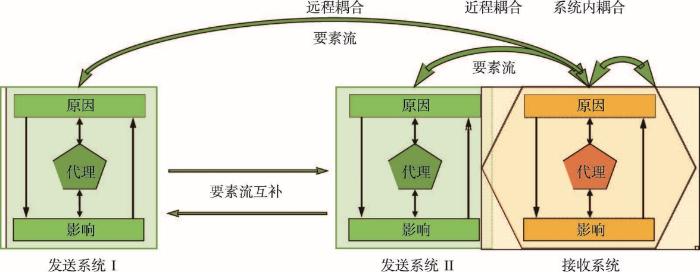
图1
人地系统全程耦合示意图
Fig. 1
Schematic diagram of metacoupling of coupled human and natural system
3.2 食物系统纽带
由于全程耦合及农地利用转型本身的复杂性,在将全程耦合框架引入农地利用转型研究时需要找到切实可行的抓手。食物系统作为衔接乡村与城市、以及产地与全球消费市场的产业链和价值链,是追踪全程耦合过程进而揭示农地利用转型“遥相关”机理的重要切入点。食物系统,这一源于“食物链”及“农业综合体”研究的概念[97],是指“农业与下游经济主体之间各种关系的总和”[98]。食物系统既是一种现象存在,也是一种认知方法[99]。作为现象存在的食物系统,是由初级农产品生产、食物加工、流通、消费和废弃物处理等社会分工环节共同组成的开放复杂系统[98],本质上是生态系统服务流及其价值实现的“社会—经济—空间”组织形式[9]。而作为认知方法的食物系统,不仅具有概括食物生命周期的理论性,也具有追踪这一过程的操作性,因此明显符合默顿有关“中层理论”[100]的定义③(③ “中层理论”(Theories of Middle Range)是由美国社会学家Robert K.Merton提出的一种社会学理论范式,是指介于较低层次的操作性假设与系统化统一理论之间的理论层次。中层理论具有实践经验性、范围有限性、开放性和联系性,是宏观理论和微观理论之间的对话桥梁。本文将食物系统作为中层理论,目的正是要在全程耦合理论框架与农地利用转型之间建立对话桥梁,以促进全程耦合理论的具体化。)。Meyfroidt等指出为有效揭示土地利用“遥相关”的因果机制链,有必要在土地系统科学中引入“中层理论”[101]。而食物系统在全程耦合视角下的农地利用转型研究中正好可以扮演“中层理论”角色。
做出上述判断的依据,不仅在于食物系统是连接城市与乡村的一条纽带,更在于食物本身作为一类重要生态系统产品,与土地有着天然的密切联系。在可预见的将来,土地仍将长期作为食物生产依托的主要自然资源。联合国粮农组织统计数据显示,2015年全球农业用地占陆地面积的比重为37.27%,其中,食物系统(包括生产可食用农产品和牧草)约占全球农业用地的93.7%,仅约6.3%的农业用地用于纤维和能源作物生产[102]。可见,农地利用主要面向食物系统,并且是食物系统的基础性环节。
特别在全球流动背景下,国际国内跨区域的食品贸易联系十分紧密,食材的地方性特征日益弱化[103],食物系统发生了在地化到去地化的显著转型[95],大城市的食物安全正日益紧密地与周边以及更遥远区域的土地利用、农户生计和生态系统关联起来。食物系统不仅包含从生产加工到消费、废弃物处理的食物供应链全过程,还蕴含着农业文化遗产、膳食结构模式和饮食文化等物质及非物质的文化要素。这种内在构成决定了食物系统是连接城市与乡村、关联人类与自然、融贯物质与文化的强大纽带,鉴于食物系统在多部门、跨区域及跨界面交互方面的多向度联系特质[9],以及作为连接乡村与城市的产业链和价值链,能够作为大食物观背景下构建新型工农城乡关系、推动城乡融合发展与乡村振兴的重要抓手[9,104];食物系统生产端的农地利用转型与农业高质量发展和乡村产业振兴息息相关,其整体转型目标与乡村振兴的总体要求协调一致[105]。通过加强农地利用转型调控促进乡村转型发展[3],构建高产高效、绿色低碳、健康营养、富有韧性和包容性的食物系统[106],进而支撑乡村振兴战略实施[105,107]是解决中国新时代“三农”问题的重要途径。因此,将食物系统融入全程耦合理论框架[71]并据此研究城乡要素流驱动下的农地利用转型,不仅具有突出的科学价值,也具有重要的现实意义。同时,由于各国跨区域食品贸易中人地系统近远程耦合具有普遍性,因此本文提出的理论框架对于他国案例研究也具有一定的参考价值。
4 城市食物系统全程耦合下农地利用转型研究的分析框架
4.1 城市食物系统全程耦合下农地利用转型的概念内涵
一方面,城乡人口迁移导致农村劳动力大量流失,农地经营成本上升,进而引发农业生产要素的重新配置。基于要素流动过程和远程耦合的底层逻辑,农业生产要素可分为域内和域外两种类型:前者包括域内固有的水、土等自然资源及其区位、质量等自然属性,以及投入食物生产的域内社会经济资源;后者主要是从域外城市溢出或回馈的人才、资金、技术、信息等先进要素。另一方面,城市人口集聚产生了巨大的食物需求,而要素非农化导致城市食物生产能力弱化,需要从近端和远端腹地获取食物供给。在此过程中,市场导向下的供求机制、价格机制和竞争机制在农地利用的资源配置方面起到决定性的作用。而政府为缓解信息不对称、要素盲目流动、恶性竞争等非理性市场经济行为对农地利用的负面影响,则通过制度设计与政策安排对农地利用施加引导性、弥补性和规制性作用。基于此,城市食物系统全程耦合下的农地利用转型机制可归结为“三路融汇、四力协同”(图2)。其中,“四力”是指在城市食物系统近远程耦合演化中推动农地利用转型的四种力,即资源内禀力、要素外驱力、市场配置力和政府调控力;“三路”则是城市通过要素流反作用于农地利用的三条路径,包括生产要素回馈路径、本地食物短缺路径和需求驱动路径。
图2
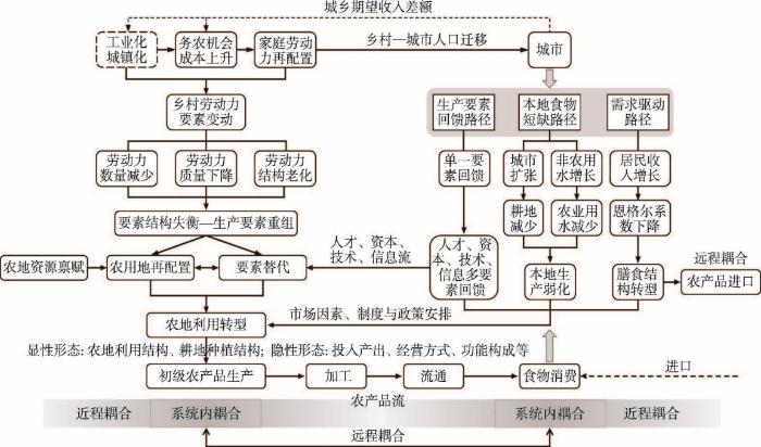
图2
城市食物系统全程耦合下农地利用转型的概念框架
Fig. 2
Conceptual framework for agricultural land use transition under the metacoupling framework of urban food system
具体而言,在工业化和城镇化进程中,由于非农工资收入远高于农业收入,使得务农存在很高的机会成本,现实的城乡收入差距和非农就业的高收入期望促使农户对家庭劳动力进行再配置。其中,在体能、学习和适应能力方面均具有比较优势的青壮年劳动力离土出乡、进厂进城从事非农工作。人口城乡迁移引发乡村劳动力要素的剧烈变动,主要表现为农业劳动力数量减少、年龄结构老化、人力资本下降,进而导致劳动力和土地以及先进生产要素之间的结构严重失衡,促使乡村生产要素进入新一轮的重组。重组主要体现在两个方面:① 留守农民在自身劳动力条件(人力资源禀赋)的约束下,根据农用地的区位特征、灌溉条件、肥力状况、坡度、坡向、高程、集中连片程度等农地资源禀赋进行农用地再配置,主要依据投入最小化和收益最大化原则进行农地利用结构及耕地种植结构的调整;最终使得易耕种的地块被优先利用,用工量少的种植结构得以施行,而部分耕作条件差的地块则可能退出农业生产[54],此为农地利用转型的资源内禀力。在资源内禀力方面,李升发等的研究证实了地形条件差异对平原和山区农业劳动生产率提升的影响,提升方式的不同最终导致平坦耕地机械化、规模化,而劣质坡耕地边际化[108]。② 涉及到生产要素回馈路径的作用,总体上,从城市到乡村的生产要素回馈在经历早期以农民工汇款为主要形式的单一要素回馈后,已逐渐演变为乡村振兴战略背景下人才、资本、技术、信息等多要素的回馈。城市作为区域内资本积累与融通的枢纽,以及人才培养、知识创新和技术变革的高地,是先进生产要素的主要输出地,其对乡村地区的生产要素回馈支撑了农业生产中的要素替代。要素替代主要针对农业劳动力日益老弱化和耕地压力上升等现实问题,采取劳动节约型和土地节约型两类技术进行要素替代[54]。例如,通过推广高产作物品种、引进先进管理技术、增加农业机械投入等,实现劳动生产率和土地生产率的提升。化肥、农药等农业化学品的使用也在一定程度上节省了农业劳动力,但农业化学品过度使用对生态环境的破坏性影响不容忽视。凡此种种均促进了农地利用转型,并可归结为农地利用转型的要素外驱力。
此外,市场配置力在农地利用转型中发挥着基础性的调节作用。食物系统作为衔接乡村与城市、以及产地与全球消费市场的产业链和价值链[9],自然会接受市场机制的调节。在城市食物系统的近远程耦合演化中,市场机制主要通过“本地食物短缺”和“需求驱动”两条路径作用于农地利用转型。在这里,“本地食物短缺”是指城市辖区范围内的农业生产供给相对于食物需求而言是短缺的。这种短缺状态源于人口不断向城市集中、食物总需求持续增长的同时,城市辖区却因建设用地扩张和要素非农化而导致本地供给能力不断弱化。同时,随着居民收入增长,恩格尔系数下降、食品购买力上升,叠加食物偏好多元化和需求分层差异化的影响,逐渐出现膳食结构转型。通过上述两条路径的作用,城市食物需求在数量和结构上都发生了极大变化。需求变化特别是膳食结构转型导致农产品供求关系变动,进而通过供求机制、价格机制和竞争机制的相互作用,并叠加城乡居民对农业景观休闲功能的市场需求,共同引起农业生产条件组合的变化,推动农地利用转型。例如,随着膳食结构转型,城乡居民消费水平提高促使农户转向专业化种植经济效益更高的作物,从而带来种植结构的动态调整[23]。
值得注意的是,食物具有明显的双重属性,虽然在生产和消费环节可视为私人物品,但从国家层面、从交换和分配环节来看则具有明显的公共物品属性,需要保障整个社会的粮食安全。因此,为避免经营主体一味追求经济效益,使耕地“非粮化”甚至非农化进而影响国家粮食安全,政府通过制度和政策安排,对农地利用施加宏观调控便十分重要。目前,国家在自然资源和“三农”领域实施的一系列宏观政策和制度安排为强化农地利用转型调控、规范农地利用行为、促进农用地高效合理利用进而更好地保障国家粮食安全和支撑居民膳食转型提供了政策依据和制度遵循。如基本农田保护制度、高标准农田建设工程、保护价收购政策、粮食直补政策、农业供给侧结构性改革、大食物观等政策和制度对农地利用具有直接和实质性的影响,因此也是农地利用转型的重要驱动力。
4.2 城市食物系统全程耦合下的农地利用转型解释
深入解析城市食物系统全程耦合下的农地利用转型需要采取地理空间网络化思维[109],即在明确城市食物域格局特征的基础上,针对食物域内的特定地点或区域,需要将其放置于“网络—面域—要素流”组成的地理空间网络中去加以审视[95]。也就是需要将食物域内的“流空间”与地点空间整合起来,开展基于食物供应链网络的跨系统综合研究。其中,网络既包括供人员和物资(如农业生产资料、农产品)流通的道路等基础设施网络,也包括产业链中具有技术经济联系的生产网络;面域作为食物系统内部要素流的源头,是支撑网络结构运行的基底,主要包括耕地、园地、林地、牧草地和养殖水域等农业生产空间;要素流则包括与食物系统直接或间接相关的农产品流、资金流、生产资料供应、技术扩散、信息流(农产品市场信息、制度与政策信息)、农业劳动力转移、科技人才下乡等。
开展食物供应链网络跨系统综合研究的核心是厘清城乡地域系统之间要素流互馈及其对农地利用转型的驱动机制。在厘清要素流关系的基础上,遵循“社会—经济动态”和“社会—生态反馈”的级联驱动路径,分析要素流在食物系统不同环节之间、以及城乡地域系统之间的传递和反馈过程,从要素供求以及环境层面(如流域层面)连接到案例区的其他多个区域出发,来解释案例区的农地利用转型,进而又循着反馈回路同步解释其他案例区的土地利用转型,因此有望实现对传统研究范式中固定区位视角的超越。
由于要素流驱动在农地利用转型机制中占有重要地位,因此有必要进一步探讨要素流发挥作用的几种效应。总体而言,连接地点空间的要素流具有5种效应,即触发效应、回波效应、重组效应、外溢效应和中断效应,并且在食物系统全程耦合下的农地利用转型中均有相应体现。
(1)触发效应:触发效应是地理流对接收系统的直接影响,这种影响具有立竿见影之效,通常并不会显著改变原有的系统要素构成,但可能会短暂增强或削弱系统的某些功能。例如知名主播在农产品收获季节到乡村开展直播带货活动,显著提高了当地农户的经营性收入,进而提升了农地利用的经济功能;而节假日期间大量游客涌入乡村旅游地虽然能够增加经济收益,但也可能给当地生态环境造成压力,削弱农地利用的生态功能。
(2)回波效应:是指一种要素从发送系统进入接收系统后,促使接收系统的其他要素类型或该类要素的新形态返回发送系统所产生的影响,在中国语境下主要指乡村人口迁移到城市后促使人才、资金、技术和信息等生产要素回流的现象。回波效应会显著改变发送系统的生产要素构成,是农业经营主体实施要素替代的主要源泉,在生产要素回馈路径中有充分的体现。例如,外出农民工向家乡汇款、大学生返乡创业、在城市积累了一定资本和技能的农民工回乡发展、农业科技人员下乡服务等等,均对农地利用转型产生了推动作用。
(3)重组效应:是指由于一种或多种生产要素在地区间及部门间流动,使得原先相对均衡的生产要素组合状态被打破,进而推动生产要素在新的生产函数下重新组合的过程,也称为要素再配置效应。可转移要素的空间位移是要素再配置的基本条件之一,对于可转移要素而言,无论是要素的流入区亦或是流出区,要素流动本身均会导致潜在的要素再配置过程。例如,农业转移人口外出务工客观上要求城市增加就业岗位的同时,也引发了乡村劳动力要素的剧烈变动,导致农用地的再配置;再如,城市消费流加速电商和现代物流业蓬勃发展的同时,也推动了农业经济的数字化,带来全新的农业要素配置、组织分工以及农村功能的转变与空间重构[110]。实际上,要素再配置是农地利用转型解释中最重要、最核心的微观机制,在劳动力要素变动、产业信息流动和资本下乡带来的农用地再配置和要素替代中均有体现。
5 城市食物系统全程耦合下农地利用转型研究的主要内容
为了更好地支撑案例研究的开展,有必要进一步设计食物系统全程耦合下农地利用转型研究的内容体系(图3)。在人地系统近远程耦合演化和城乡关系深刻转型的大背景下,城乡要素流动、食物系统变化与农地利用转型之间的互馈作用构成了土地利用“遥相关”的重要内容。对此,亟需超越固定区位视角与本土思维模式,按照“食物系统近远程耦合演化—农地利用转型—经营主体响应—转型调控”的总体思路,对城市食物系统全程耦合下的农地利用转型机制、城市食物域内农地利用形态的空间差异及演变规律、农地利用对需求变化的响应水平及影响因素、以及农地利用转型调控开展系统研究,以助力食物安全保障、支撑乡村振兴战略实施,并为解决新时代的“三农”问题提供思路参考。
图3
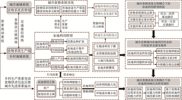
图3
城市食物系统全程耦合下农地利用转型研究的内容体系
Fig. 3
Content system of research on agricultural land use transition under the metacoupling framework of urban food system
5.1 城市食物系统全程耦合下的农地利用转型机制
城市化驱动下的要素非农化对乡村传统“人地业”模式产生剧烈冲击。非农产业的迅猛发展以及非农工资的快速提升促使农业劳动力向城市大量流动,城市人口集聚、外来人口比例增大、居民消费水平提高和收入分化意味着食物需求的持续增长和膳食结构的多元化转型。同时,城市空间扩张和生态建设不断挤占农业空间,导致本地农业生产弱化、食物自给能力下降,必须提升食物外埠供应比重,以缓解城市食物系统中的供需矛盾。食物系统需求端的变化通过供应链和物流体系反馈给近远程的生产端,引起农地利用空间结构和功能形态的变化与转型。另一方面,城市食物系统全程耦合也使得与食物相关的资源环境压力向乡村转移,尤其是市场需求导向下耕地种植结构由粮食作物向高耗水型园艺作物调整,加大了外埠供应地的水资源压力。另外,农业生产要素变动和居民膳食结构转型不可避免地要求农地再配置,为节约劳动力和土地而加大农用化学品和机械动力投入的农地利用集约化,与因缺乏劳动力而弃耕撂荒的农地边际化同时存在,农地生态系统将面临更为严峻的生物多样性下降、土地退化、地下水耗竭等生态环境风险。
基于以上讨论,农地利用转型机制研究应通过梳理城市食物系统全程耦合演化过程,首先对城市化驱动下的城市食物系统变化过程与现状特征进行统计分析,定量识别城市化驱动下人口集聚、收入增长、空间扩张、生态建设等导致食物多元需求增长、食物自给率下降进而引起食物生态足迹扩张的关键变量。以分析关键变量的协同作用及其深层驱动力为突破口,遵循“社会—经济动态”(农业劳动力析出→城市人口集聚→城市食物需求增长、膳食转型→需求结构反馈→农地利用转型)和“社会—生态反馈”(食物外埠供应增加→农用地再配置→资源环境压力转移;农业劳动力析出→农用地再配置→农地边际化、农地流转集约→农地生态风险加大)两条作用路径[4],将隐含于食物生产—流通—消费全生命周期的近远程人地互动关系纳入到农地利用转型机制的研究中来,以明晰城乡土地利用“遥相关”的内在机理。
5.2 城市食物域内农地利用形态的空间差异及演变规律
城市食物系统全程耦合演化映射于农地利用形态转型过程之中,市场需求导向下的种植结构调整以及生产要素变动下的投入结构和经营模式调整,促使农地利用的空间结构和投入产出效率加速演变。随着要素市场逐渐走向成熟,城乡居民对农地利用的需求由最初单纯的食物供应转向兼具更高层次的景观休闲、环境健康和绿色食品消费,休闲农业、观光农业、智慧农业、农产品生态认证等新业态的发展促使农地生态保育功能和经济贡献功能增强,农地利用向功能多元化、功能融合化方向转型。除此之外,因供应距离和农产品优势种类的差异,各外埠供应地受城市食物系统远距离影响的程度不同,进而产生时空分异,表现出不同的农地利用形态变化特征。
城市食物域内农地利用形态的空间差异和演变规律作为食物系统全程耦合的直观表达,是土地利用遥相关研究的重要内容。农地利用形态空间差异及演变规律研究应以城市主要农产品供应量为依据反映城乡地域系统的全程耦合程度,验证在不同程度的空间相互作用下农地空间布局、种植结构等显性形态与农地集约度、农地生产率、农地功能构成等隐性形态是否存在以城市为中心的梯度变化规律,以及研究农地利用显隐性形态各指标两两之间呈现何种时空耦合关系。并且在兼顾外溢系统(其他城市)的情况下研究城市食物系统近远程耦合演化对农地利用形态的影响。
5.3 城市食物系统全程耦合下的农地利用响应及转型调控
农户、家庭农场、农民专业合作社、农业企业等利益相关者作为农业生产和农地利用的经营主体,其空间行为和决策能力是农地利用变化与转型的主导因素。城乡融合进程伴随着要素的交互重组,面对日益频繁的劳动力迁移、错综复杂的市场信息反馈以及日新月异的农业技术革新,经营主体需要适时地调整农地利用策略和经营模式,适度扩大优势品种种养殖规模、引进现代化机械设备、调整农地经营方式、开发农地多元功能、提升农地生态服务价值,才能更好地响应食物系统需求端的变化,以谋求利润最大化和负面环境影响最小化。在此过程中,从农地利用形态变化过程出发,评估农业经营主体获取和利用市场需求信息的能力,并针对性地提升其需求响应水平以促进农地利用转型调控,对于解决农业产值贡献率低、农民兼业经营、农地粗放利用甚至弃耕撂荒等“农业边缘化”问题[114]、推动农业高质量发展至关重要。
开展城市食物系统全程耦合下的农地利用响应及转型调控研究,首先应以结构调整能力、要素替代能力、功能转型能力和经营效益作为响应水平评估的基本维度,通过实地调研和比较研究,评价不同经营、流通模式下农地利用形态和经营主体行为对需求变化的响应水平,并分析引起响应能力差异的影响因素。农地利用转型调控是系列研究的最终目标,基于农地利用的转型机制、演变规律及需求响应研究,借鉴国内外土地利用转型调控经验,在充分重视城乡全程耦合系统中乡村代理的主体作用和城市先进要素溢出效应的基础上,因地制宜地提出农地利用转型调控方案。通过开发农产品市场供求信息平台,以大数据赋能农业生产;充分利用城市资本/技术溢出,支持农地利用的智能化、绿色化转型;构建“流通主体+新型经营主体+农户+数据服务”的城乡融合经营模式,培育农业新生动力,实现小农户与现代农业的有机衔接。最后还应当注重产学研融合,将农地利用转型调控方案及时反馈给相关案例区的地方政府和经营主体,以真正发挥系列研究的现实参考价值和实践指导作用。
6 结语
在空间连通性不断增强的全球化、城市化时代,人口、资本、技术、信息、原材料、商品等要素流动呈现多元化、广域化和常态化的趋势,近远程要素流驱动成为人地系统演化和城乡关系演变的新动因。而面对农地利用转型乃至土地利用转型研究领域“遥相关”视角的不足、以及“遥相关”视角下系统化理论建构的缺位,亟需以更加开放的思维、挖掘多尺度要素流的相关理论来探索土地利用转型规律与机制。对此,本文在论证理论创新科学基础的前提下,提出将具有整合“流空间”与地点空间特性的全程耦合框架引入农地利用转型研究,将具有多向度联系特质的食物系统作为追踪全程耦合过程的重要切入点,从城市食物系统全程耦合视角来揭示农地利用转型的“遥相关”机理。并进一步明确城市食物系统全程耦合下农地利用转型的“三路融汇、四力协同”机制;深入探讨了地理空间网络化思维的必要性,提出了整合“流空间”与地点空间的农地利用转型解析方法,即从要素供求以及环境层面连接到案例区的其他多个区域出发,或根据实际需要通过揭示要素流的5种效应来解释农地利用转型。未来城市食物系统全程耦合下的农地利用转型研究需要重点关注农地利用转型机制、城市食物域内农地利用形态的空间差异及演变规律、农地利用对需求变化的响应水平及影响因素、以及农地利用转型调控等几个方面的内容。
需要补充强调的是,理论研究的目的在于实际应用。面向未来,以地理空间网络化思维和全程耦合理论框架为指导,围绕“三路融汇、四力协同”的农地利用转型概念框架和“社会—经济动态”与“社会—生态反馈”级联驱动的解析路径,亟需就城市食物系统全程耦合下的农地利用转型开展系列实证研究。值得注意的是,城市食物系统全程耦合下的农地利用转型研究需要使用多种要素流数据,由于目前生产端尤其大量小农户不掌握农产品流向,对流量情况也常常疏于统计,而产地批发市场又往往将农产品物流数据视为商业机密,因此开展相关研究尚存在较为突出的挑战。虽然从城市批发市场能够获取部分农产品的产地来源数据,但从以往研究经验来看,这类数据的空间精度较低,往往仅统计到省级行政区。针对以上问题及挑战,未来应当加强与农产品流通企业的战略合作,通过合作呼吁实业界将部分农产品物流数据面向研究开放。其次,应当不断创新研究方法,探索将农产品物流大数据与实地调查小数据相结合的研究方式;应当注重典型案例研究,通过对典型案例的详细调查,将其放置于地理空间网络中加以全面审视和深度剖析,以实现农地利用转型研究的“以小见大,见微知著”。
参考文献
Urban expansion and its consumption of high-quality farmland in Beijing, China
DOI:10.1016/j.ecolind.2015.02.015 URL [本文引用: 1]
Forest transition, agricultural land marginalization and ecological restoration
森林转型、农地边际化与生态恢复
Land use transition and rural transformation development
DOI:10.11820/dlkxjz.2012.02.001
[本文引用: 3]

Recently, related researches on land use transition combining with the characteristics of China’s socio- economic development have been carried out rapidly since the research field of land use transition was introduced to China. Land use morphology is the key content of land use transition research. However, the concept and connotation of land use morphology has been developed continuously with the in-depth research and socio- economic change and innovation. Based on the analysis of the evolvement of the concept and connotation of land use morphology, this paper argues that there are two formats for depicting land use morphology: one is dominant morphology, and the other is recessive morphology. The dominant land use morphology refers to the quantity, structure and spatial pattern of land use, and the recessive land use morphology includes the land-use features in the aspects such as quality, property rights, management mode, fixed input and productive ability. Then, a conceptualization of the models of land use transition was annotated based on the two formats of land use morphology. Land use transition refers to the changes in land use morphology of a certain region over a certain period of time driven by socio-economic change and innovation, and it usually corresponds to the transition of socio-economic development phase. Rural transformation development means the restructuring of rural socio- economic morphology and territorial spatial patterns resulted from local actors’responses and readjustments to the change, recombination and interaction of socio-economic development factors and rural-urban migration in the process of rapid urbanization and industrialization, including the changes in traditional rural industries, the employment mode, the consumption structure, and the social structure. Such transformation radically changes the urban-rural relationship and the relationship between agriculture and industry. Since farmland and rural settlement are the engines driving land use transition and rural transformation development, the interaction between rural transformation development and farmland and rural settlement transition was analyzed to understand the relationship between land use transition and rural transformation development. Finally, the future research fields concerning land use transition and rural transformation development were suggested as follows: the dynamic pattern and territorial type of land use transition and rural transformation development; the interaction and dynamical mechanism of land use transition and rural transformation development; the resources and environment effects of land use transition and rural transformation development; and the ways and countermeasures of optimizing and adjusting land use transition and rural transformation development.
论土地利用转型与乡村转型发展
DOI:10.11820/dlkxjz.2012.02.001
[本文引用: 3]
土地利用转型这一研究方向引入中国后,结合中国社会经济特点的相关研究篷勃开展。土地利用形态是土地利用转型研究的核心内容,在社会经济变化和革新的影响下,随着研究的不断深入,土地利用形态的概念内涵被不断拓展。本文在分析土地利用形态概念内涵的发展演变基础上,提出将其分为显性形态与隐性形态两种形式,并以此诠释了土地利用转型的概念模式,进而探讨了土地利用转型与乡村转型发展之间的关系。研究指出:耕地和农村宅基地这两种地类乃乡村发展与土地利用转型之重要源头。随后探讨了乡村转型发展与耕地和农村宅基地利用转型之间的相互作用关系。最后提出未来土地利用转型与乡村转型发展的研究方向,涉及土地利用转型与乡村转型发展的格局与地域类型、互馈作用机理与动力机制、资源与环境效应、优化调控模式和途径等方面。
Land use transitions: Socio-ecological feedback versus socio-economic change
DOI:10.1016/j.landusepol.2009.09.003 URL [本文引用: 2]
Discussion on land use transition research framework
DOI:10.11821/dlxb201703009
[本文引用: 4]
Land change has been a hot topic in geographical research. The overarching and convincing theories of land change science, however, have not emerged. Establishment of land use transition theory is of significance for the theory basis of land change science. This paper attempts to establish a research framework of land use transition based on summarizing the development and implications of land use transition research and clarifying the differences between land use transition and land use change. Results show that transition research of artificial ecosystems, such as cultivated land, rural housing land and urban land, is of significance. Land use transition is distinguished from land use change on several aspects, such as fundamental types, temporal scale, spatial scale, agents, driving forces, trajectory, and results or effects. Research framework of land use transition covers transition diagnosis, mechanism research and effects research. Key issues of transition diagnosis are the establishment of measuring indices and diagnosis principles of land use spatial and functional morphologies from the perspectives of quantity change, landscape pattern change and management pattern change, and of land use externality and land use policy development. Mechanism of land use transition behaves as cascading effects of underlying driving factors of land use change, including demographic, economic, technological, institutional, cultural, and location factors. Mechanism research should place emphasis on interaction between land use spatial transition and functional transition. Effects of land use transition covers at least 17 themes relating to social, economic and environmental dimensions. Cultivated land use transition in France in 1961-2011 confirms the research framework of land use transition and is beneficial to the innovation of cultivated land protection in China.
论土地利用转型的研究框架
DOI:10.11821/dlxb201703009
[本文引用: 4]
当前,土地变化研究尚缺乏统一的理论指导。探索土地利用转型理论对构建土地变化研究的理论基础具有重要意义。本文试图梳理土地利用转型研究的缘起、拓展及启示,辨析土地利用转型与土地利用变化的内涵差异,构建土地利用转型的研究框架。结果表明:① 耕地及城乡建设用地利用转型研究对构建土地利用转型的研究框架具有重要价值;② 土地利用转型与土地利用变化在基本类型、时间尺度、空间尺度、价值主体、驱动因素、轨迹特征和结果/影响方面存在显著差异;③ 土地利用转型的研究框架涵盖转型诊断、机制研究和效应研究。其中,转型诊断的关键在于,从数量变化视角、景观格局变化视角和经营格局变化视角,以及外部性视角和政策发展视角,构建土地利用空间形态及功能形态的分析指标和转型的诊断准则;转型机制表现为人口、经济、技术、制度、文化和区位因素等土地利用变化深层驱动因素的级联驱动效应。转型机制研究应当着重探讨土地利用空间转型与功能转型的互动机制环;土地利用转型效应包括社会、经济、环境3个方面;④ 1961-2011年法国耕地利用转型能够支撑本文提出的研究框架及中国耕地保护创新。
Research progress and prospect of telecoupling of Human-Earth system
DOI:10.18306/dlkxjz.2020.02.012
[本文引用: 7]
Achieving sustainable development in an increasingly interconnected globalized world requires cross-system thinking and more integrated regional policy. First, it requires disciplines devoted to sustainable development research to improve their insights into trans-regional resource and environmental issues. Accordingly, it is necessary to promote the adaptive innovation and transformation of the traditional research framework of geography. Telecoupling, as a theoretical framework focusing on socioeconomic and environmental interactions among coupled human and natural systems over distances, has great potential and advantages to facilitate the process of theoretical innovation. In order to narrow the gap between Chinese and international research in the field of telecoupling, we introduce the telecoupling framework and its application progress from theoretical construction, empirical evidence, key research areas, and research methods based on literature review, document analysis, and our own understanding of telecoupling, and further give some suggests. The review shows that there is a large amount of empirical evidence of telecoupling in the dimensions of teleconnection, globalization, and urbanization due to the continuous growth of long-distance human activities and their interaction with large-scale natural processes. Currently, the application of the telecoupling framework in academia mainly focuses on three aspects: ecosystem services, the socioeconomic and environmental impacts of telecoupling, and land change science. Due to the progress in operationalizing the theories, current telecoupling research has been well supported methodologically. We further argue that geographical research based on the telecoupling framework should make breakthroughs in the theoretical innovation of Human-Earth relationship network system, telecoupling mechanism, and telecoupling regulatory tool sets, so that scientific research can keep up with the latest trends and solve the emerging real world problems.
人地系统远程耦合的研究进展与展望
DOI:10.18306/dlkxjz.2020.02.012
[本文引用: 7]
在越发紧密关联的全球化世界中,如何实现可持续发展日益需要跨系统思维和超区域政策。这首先要求致力于可持续发展研究的学科要提升自身对跨区域资源环境问题的洞察力,因此就有必要推动地理学传统研究框架的适应性创新和变革。远程耦合作为聚焦于“远距离人类与自然耦合系统之间社会经济与环境相互作用”的理论框架,有极大的潜力和优势来促进这一理论创新进程。为了缩小国内外在远程耦合领域的研究差距,论文基于文献研究和笔者对远程耦合框架的理解,从远程耦合的理论建构、经验证据、重点研究领域和研究方法4个方面介绍了该理论框架及其应用进展,并提出3个方面的展望来激发新的研究。综述表明,由于远距离人类活动不断增长以及大尺度自然过程与人类活动的相互作用,在远程连接、全球化和城市化维度上均存在大量远程耦合的经验证据;目前学术界对远程耦合框架的应用主要集中于生态系统服务、远程耦合的社会经济和环境影响及土地变化科学3个方面;同时得益于理论操作化的进展,目前开展远程耦合研究已具备较好的方法支持。基于此,论文认为,为应对新兴的现实科学命题,基于远程耦合框架的地理学研究应当在人地关系网络系统的理论创新、远程耦合动力机制和远程耦合的调控工具集3个方面实现突破。
Urban land teleconnections and sustainability
Evidence of urban land teleconnections and impacts on hinterlands
DOI:10.1016/j.cosust.2013.08.003 URL [本文引用: 2]
Theoretical framework and research priorities on food system couplings in an urbanization context
DOI:10.11821/dlxb202110002
[本文引用: 8]
Driven by urbanization, regional functional differentiation, optimal allocation of production factors, and rapid expansion of transportation networks, the flow of resources between regions has become a key impetus for regional sustainable development. Hence, the interaction networking between human beings and their natural environment requires a meta-coupling paradigm research from a geographic perspective, that is, to consider the human-nature interactions within the region, between the region and surrounding regions, and between non-adjacent regions simultaneously. As an industrial chain and value chain that connects rural areas and cities, as well as production areas and global consumer markets, the research on food system couplings is a good and important entry point for a better understanding the interactions and networking in the human-earth system. With this perspective in mind and aiming at demonstrating the theoretical study based on internal basis and external conditions, this paper combines the food system components with the tele-coupling framework to establish a "theoretical framework of local and tele-coupling of food systems driven by urbanization", and discusses the specific connotation of the theoretical framework. Taking the extension of the frontier fields in the theoretical framework as the basic guide and combining China's major strategic needs, the paper further identifies the basic issues for food system coupling research and four priority research directions that need to be breakthrough. Among them, the pattern characteristics, the spatio-temporal evolution and its driving mechanism of foodshed are the basic issues, while the four research priorities include: human-nature interaction research of the supply chain network coupling socio-economic and cultural changes and biogeochemical cycles; effects of the local and tele-coupling of food system and its regulatory strategies; the mechanism of urban-rural integration and long-term poverty alleviation based on food system; and cross-regional multi-level governance of food systems for public health and food security. A general technical methodology of the food system coupling research is designed at the end of the paper. The conceptual framework and methodology in this paper can provide theoretical guideline and enlightenment for further food system coupling research and other similar studies.
城市化背景下食物系统耦合研究的理论框架及优先方向
DOI:10.11821/dlxb202110002
[本文引用: 8]
受城市化、地域功能分化、生产要素优化配置和交通网络快速扩展等因素影响,区域之间资源要素的流动已成为区域可持续发展的内在需求。在这种背景下,人类与地理环境互动模式的网络化就要求地理学研究采取全程耦合范式,即将区域内部、区域与周边区域、以及非邻接区域之间的人地互动同时纳入考虑。食物系统作为衔接乡村与城市、以及产地与全球消费市场的产业链和价值链,是开展人地系统近远程耦合研究的重要切入点。基于这种认识,本文在论证理论研究内在依据及外在条件的基础上,将食物系统的构成要素与远程耦合框架相结合,建立“城市化驱动下食物系统近远程耦合的理论框架”并论述该理论框架的具体内涵。以拓展理论框架中的前沿领域为基本导向并结合国家重大战略需求,本文进一步明确了食物系统耦合研究的基本问题和4个亟待突破的优先研究方向。其中,基本问题是食物域的格局特征、时空演化及其动力机制。4个优先方向则包括:耦合社会经济文化变迁与生物地球化学循环的供应链网络人地互动研究;食物系统近远程耦合效应及其调控策略研究;基于食物系统的城乡融合与长效脱贫机制研究;以及面向公共卫生安全的食物系统跨区域、多层次治理研究。本文最后设计了食物系统耦合研究的一般技术路径,研究结果可为进一步的案例实证提供理论支撑和研究思路参考。
National land use morphology: Patterns and possibilities
Land use transition and land management
DOI:10.11821/dlyj201509001
[本文引用: 1]
With the introduction of land use transition to the academic circle of China since the turn of the new millennium, related researches combining with the characteristics of China's socio-economic development have been carried out extensively. Recently, issues related to land use transition in China have attracted interest among a wide variety of researchers as well as the government officials. Land use transition refers to the changes in land use morphology including dominant morphology and recessive morphology of a certain region over a certain period of time driven by socio-economic change and innovation. In general, dominant land use morphology refers to the quantity, structure and spatial pattern of land use, and recessive land use morphology includes land use features in terms of aspects of quality, price, property rights, management mode, input and productive ability, and function. This paper puts forward the theoretical model of regional land use transition as the following: with the socio-economic development, the transformations between different land use types during a certain period of time arise the changes of regional land use morphology pattern from strong conflict to weak conflict, i.e., coordination, which enable a new balance between different land use morphology patterns reflecting the development trend of different economic departments, and then realize the transformation of urban-rural land use system from quantitative change to qualitative change. Then, the mechanism of mutual feedback between land use transition and land management was probed based on a three-fold framework of natural system-economic system-managerial institution system. Generally, land use transition is affected by land management via economic measures, land resources engineering, policy and institution. Land use transition can also contribute to the adjustment of land management measures via socio-ecological feedback. Therefore, policy-makers need to adjust their land management policies taking into account the continuous change of land use morphology and different phases of regional land use transition. Under the background of urban-rural transformation development, the researches of land use transition and land management may focus on how to measure the transitions of land use dominant morphology and recessive morphology and the subsequent transition of the function of land use system, how to measure the socio-economic and environmental effects of land use transitions, how to refine the popular model of regional land use transition, and how to adjust land use transition via socio-economic and engineering measurements. Finally, the author argues that more attentions need to be paid to the recessive morphology of land use, the change of which is the key to policy and institution innovation and improving land management.
论土地利用转型与土地资源管理
DOI:10.11821/dlyj201509001
[本文引用: 1]
自21世纪初土地利用转型这一研究方向引入中国后,土地利用转型已成为当今学术界和国家行政部门十分关注的重要课题。在拓展深化土地利用转型的概念内涵,阐述土地利用转型的理论模式基础上,探讨了土地利用转型与土地资源管理二者之间的互馈机制,进而分析了土地利用转型与土地资源管理二者之间的相互影响。研究指出:决策部门应根据土地利用形态的变化适时调整土地资源管理政策措施,充分考虑目标区域所处的土地利用转型阶段,以增强土地资源管理决策的科学性。在探讨未来土地利用转型与土地资源管理研究方向基础上,强调土地利用隐性形态及其变化应当成为今后土地利用转型与土地资源管理研究关注的焦点,通过管控土地利用隐性形态的变化来创新土地资源管理政策法规及制度,提升土地资源管理水平。
Effects of active and passive land use management after cropland abandonment on water and vegetation dynamics in the Central Spanish Pyrenees
The effects of farmland conversion on livelihood assets in peri-urban areas of Addis Ababa Metropolitan city, the case of Akaki Kaliti sub-city, Central Ethiopia
A longitudinal study of agriculture households in Indonesia: The effect of land and labor mobility on welfare and poverty dynamics
Drivers of change in mountain agriculture: A thirty-year analysis of trajectories of evolution of cattle farming systems in the Spanish Pyrenees
Analysing how drivers of agricultural land abandonment affect biodiversity and cultural landscapes using case studies from Scandinavia, Iberia and Oceania
DOI:10.1016/j.landusepol.2013.07.003 URL [本文引用: 1]
The effects of farming intensification on an iconic grassland bird species, or why mountain refuges no longer work for farmland biodiversity
A systems approach to forecast agricultural land transformation and soil environmental risk from economic, policy, and cultural scenarios in the north central United States(2012-2062)
DOI:10.1080/14735903.2017.1288029 URL [本文引用: 1]
Cultivated-land transition and land consolidation and reclamation in China: Research progress and frame
中国耕地转型与土地整理: 研究进展与框架
Route of cultivated land transition research
DOI:10.11821/dlyj201403001
[本文引用: 2]
Land use transition research (LUTR) is currently evolving from description to explanation as a whole. Moreover, it focuses on forest transition from spatial perspectives. It is obliged to promote the LUTR to achieve land use regulation according to human needs. For example, domain of the LUTR should be expanded to semi-natural even artificial land systems, and the non-spatial research route should be emphasized. This paper presents the research route of cultivated land transition conforming to dual deconstruction from the perspective of spatial and functional morphologies of land. The research route concerning spatial morphology focuses on the long-term process of change in spatial distribution of cultivated land. From this point of view, cultivated land transition could be diagnosed by analyzing changes in cultivated land amount or pattern. In the meanwhile, the research route concerning functional morphology show concern on the evolving cultivated land functions. From this viewpoint, cultivated land transition could be diagnosed from externality or policy evolution perspectives. The process of spatial transition of cultivated land forced by socio-economic dynamics is dominated by the functional transition forced by negative socio-ecological feedbacks. Based on this understanding, the framework of cultivated land transition regulation and its analysis level system are established.
耕地转型的研究路径探讨
DOI:10.11821/dlyj201403001
[本文引用: 2]
当前,土地利用转型研究总体上处于“描述—解释”阶段,高度集中在森林转型研究领域及空间形态研究路径。学术界亟须推动土地利用转型研究向科学调控阶段发展。对此,本文尝试提出耕地转型的研究路径,以期带动土地利用转型研究领域向半人工半自然复合土地系统乃至人工土地系统拓展、研究路径向非空间形态延伸。耕地转型诊断可以从空间形态转型与功能形态转型两条路径开展。其中,前一路径关注耕地的空间分布及其收缩与扩张,可以从耕地数量变化或格局变化视角开展研究;后一路径关注耕地功能的变化过程,可以从外部性或政策演进视角开展研究。由社会—生态负反馈驱动的耕地功能形态转型,主导着由社会—经济动态驱动的耕地空间形态转型进程。据此,作者构建了耕地转型调控框架及其层次分析体系。
Theoretical explanation and case study of regional cultivated land use function transition
DOI:10.11821/dlxb201905012
[本文引用: 3]
Changes of cultivated land use structures including type structure, input structure, and plantation structure, could succinctly reveal change of cultivated land use function morphology. Cultivated land use function transition (CLUFT) in the process of socio-economic development, however, is currently an issue to be resolved. Based on the underlying relationship between induced production substitution and cultivated land use structure change, this paper established a comprehensive explanation framework of the CLUFT. Then, the regional CLUFT was studied with Guangdong province as a typical case area. Results show that cultivated land use functional morphology in Guangdong overall entered the interim stage of the transition from socio-economic morphology to ecological and economic morphology. Cultivated land use function in the Pearl River Delta has accomplished the transition from socio-economic morphology to ecological-economic morphology. The rest of districts of Guangdong, however, accomplished the transition from socio-ecological morphology to socio-economic morphology. Both socio-economic and institutional forces drove the CLUFT in Guangdong. Mechanism of the CLUFT behaves as cascading effects of interactions among urbanization, socio-economic development, induced production substitution, changes of cultivated land use structures, and transformation of cultivated land use function morphologies. The positive analysis above justified the comprehensive explanation framework presented in this paper. That is, changes of cultivated land use structures could effectively denote cultivated land use function transition. With socio-economic development from its primary stage to an advanced one, changes of cultivated land use structures will drive transition of cultivated land use function morphology from socio-ecological morphology to socio-economic morphology, and to ecological and economic morphology under the direct force of induced production substitution. This paper presented new knowledges on morphology and transition explanations in land use transition research. Furthermore, new knowledges on the underlying mechanism of cultivated land use transition has been developed based on rethinking of the induced production substitution in agriculture. This study is of significance to bridge the knowledge gap of cultivated land use transition among scholars, the public, and policy makers and to deepen further research on land use transition. Finally, suggestions on transformation from dryland to paddy filed in southern China and control of socio-ecological effects of cultivated land use function transition were discussed.
区域耕地利用功能转型的理论解释与实证
DOI:10.11821/dlxb201905012
[本文引用: 3]
随着经济社会发展,由耕地利用类型结构、投入结构和种植结构决定的区域耕地利用功能究竟如何转型,至今悬而未决。通过分析诱致性生产替代与3种结构演变的内在联系,构建耕地利用功能转型综合解释框架及量化方法,选取广东省为典型地区,研究区域耕地利用功能转型。结果表明:① 广东省耕地利用功能处于从经济社会型转向生态经济型转型的过渡期,但区域差异明显。其中,珠江三角洲耕地利用功能实现了从经济社会型向生态经济型的转型,东翼、西翼、山区实现了从社会生态型向经济社会型的转型;② 广东省耕地利用功能转型的人文驱动机理表现为,经济—社会和社会—体制两方面的驱动力沿“城镇化发展—经济发展水平提高—诱致性生产替代—耕地利用结构演变—耕地利用功能形态转变”的级联驱动效应;③ 耕地利用结构演变分析是耕地利用功能转型研究的有效视角。随着经济社会从初级发展阶段经历中高级到高级阶段,在诱致性生产替代作用下,耕地利用类型结构、投入结构和种植结构演变将决定耕地利用功能从社会生态型向经济社会型、生态经济型转型;④ 对土地利用转型中“型”的内涵做出了新的阐释。在诱致性生产替代理论认知基础上,对耕地利用功能“型”之转变的深层机理进行了新的探索。这对缩小学术界与公众、决策层在耕地利用转型方面的认知鸿沟,以及推动土地利用转型深入研究具有重要意义。此外,提出了中国“旱改水”及耕地利用功能转型的社会生态效应管控建议。
A framework of multi-disciplinary comprehensive research on recessive farmland transition in China
DOI:10.11821/dlxb201807004
[本文引用: 1]
Currently, the "farmland red line" management has made major achievements in the quantitative protection of Chinese farmland. However, the increase of grain production as well as the improvement of peasants' incomes still calls for more researches concentrated on the recessive farmland transition based on the current resources endowment. The recessive farmland morphology has multi-properties referring different disciplines. So the study of farmland transition needs a multi-disciplinary comprehensive research framework. This paper drew an outline of the farmland transition in China since its founding, and made an in-depth literature review from multi-disciplinary perspectives of management, economics and sociology. Previous research shows an inefficient performance from the aspect of locality, integrity and systematicness. The shortcomings above may weaken its application due to lack of popularization and operability. So the authors argue that, geographical ideology and analytical method should be introduced into current researches on recessive farmland transition. And multi-disciplinary comprehensive researches should be constructed to make up the existing deficiencies. Ultimately, from the conceptual level, the overall design level, and the practical application level, this paper puts forward a multi-disciplinary comprehensive research framework for the recessive farmland transition, and illustrates a concrete application from the problem-oriented perspective.
中国耕地利用隐性形态转型的多学科综合研究框架
DOI:10.11821/dlxb201807004
[本文引用: 1]
当前,18亿亩耕地“红线”的划定对中国耕地数量保护成效显著,但要实现保障粮食安全、促进农民增收的战略目标,更多的研究仍需聚焦在既定资源数量下的耕地利用隐性形态转型上。耕地利用隐性形态包含涉及不同学科的多重属性,其转型规律的刻画需建立在多学科综合研究框架基础之上。为此,研究结合中国耕地资源管理实践,分析了1949年以来耕地利用隐性形态转型历程,梳理了分散于管理学、经济学和社会学中的相关研究进展。结果表明,当前研究在区域性、综合性、多尺度性方面表现不足,这些不足不仅影响分析结果的准确性,也弱化了研究结论在耕地管理实践中的可推广性和可操作性。因此,本文提出在现有研究基础上引入地理学的研究理念和分析方法,通过开展多学科的综合研究弥补以上不足,并进而从概念框架、具体设计、实践运用三个层次,逐步深入和细化,提出了中国耕地利用隐性形态转型研究的多学科综合研究框架,阐述了这一框架的具体应用思路。
Land use transition of mountainous rural areas in China
DOI:10.11821/dlxb201803009
[本文引用: 1]
In agricultural society, the cultivation of mountainous land was a representative of intensified contradiction between human and land which resulted in water loss and soil erosion. With the rapid urbanization and industrialization in poverty-stricken mountainous areas, the labor emigration relieves this contradiction significantly, and leads to land use transition, which results in a series of natural and socio-economic changes. This research built an analysis framework of "Land use transition - driving mechanism - effects - responses" in mountainous land use transition and then put forward the further direction of mountainous land reclamation. The results indicate that: (1) The tendency change of land use morphology was the core of rural land use transition in mountainous areas. The expansion of cropland, as well as the contraction of forest land in agricultural society, has changed to the abandonment of cropland and the expansion of forest land is the main characteristic of the dominant land use morphology transition. Land marginalization and land ecological functional recovery are the main characteristics of the recessive land use morphology transition in mountainous areas. (2) Socio-economic factors are the primary driving forces during the mountainous land use transition. Labor emigration is the direct driving forces. Meanwhile, the rising costs of farming opportunities, and the harsh living environment that lead to labor emigration are the root cause for mountainous land use transition. (3) The transition of rural land use in mountainous areas reduces the vulnerability of land ecosystem and improves its ecological security barrier function. The advantages and disadvantages of its socio-economic effects should focus on rural development of mountainous areas and the livelihood of farmers, and need to be supported by empirical and quantitative researches. (4) The transition of land use in rural areas is a benign process of natural restoration and ecological optimization. The rural land remediation in mountainous areas should conform to the law of land use transition, and the target orientation will shift from the increase of cultivated land to the synergies of ecological and environmental protection.
中国山区农村土地利用转型解析
DOI:10.11821/dlxb201803009
[本文引用: 1]
山区土地开发及其导致的资源环境问题是农业社会人地关系紧张的体现,工业化、城镇化进程中劳动力转移减轻了山区农村土地的人为扰动,由此驱动土地利用发生转型,引发一系列自然和社会经济效应。按照“土地利用转型—驱动力—效应—响应”的分析框架,剖析中国山区农村土地利用转型的特征和规律,提出山区农村土地整治的响应措施。研究表明:① 山区农村土地利用转型体现出土地利用形态在长期变化过程中的趋势性转折,显性形态转型即由农业社会的耕地扩张和林地收缩演变为城镇化进程中的耕地收缩和林地恢复性增长,隐性形态转型即伴随上述过程发生的土地边际化及生态功能恢复;② 社会经济因素主导山区农村土地利用转型过程,劳动力转移引发土地人为扰动减轻是直接驱动力,务农机会成本上升、恶劣的生存环境等引发劳动力转移的因素是更为根本的驱动力;③ 山区农村土地利用转型降低了土地生态系统脆弱性并提高了其生态安全屏障功能,其社会经济效应应聚焦山区农村发展与农户生计安全层面,并亟需实证研究的支撑;④ 当前山区农村土地利用转型是自然恢复和生态优化的良性过程,有着经济社会发展的必然规律,山区农村土地整治要顺应其土地利用转型规律,目标导向从耕地数量增加转向生态环境保护与社会经济福祉协同提升。
A study of the changing trend of Chinese cultivated land amount and data reconstructing: 1949-2003
中国耕地资源数量变化的趋势分析与数据重建: 1949—2003
Theoretical hypotheses about agricultural land use changes and the relevant propositions about environmental impacts
DOI:10.11867/j.issn.1001-8166.2008.11.1124
[本文引用: 1]
Besides the classical land rent theory, a few theoretical hypotheses exist in the explanation of agricultural land use changes in terms of both areal extent and intensity. Any change in land use has its impact on environment and ecology. And these land use hypotheses are usually extended to general hypotheses about human-land relations while environmental impacts of land use changes are taken into account. This paper reviews theoretical hypotheses about agricultural land use changes. These include ①compelled areal expansion hypothesis based on Malthus′s demographic theory; ②Boserup′s induced intensification hypothesis; ③Geetz′s elastic intensity hypothesis and ④Brookfield′s disintensification hypothesis. Some relevant propositions about environmental impacts of agricultural land use changes are also discussed. They are: ①farmland expansion results in land degradation; ②agricultural intensification of fertile lands indirectly helps improve ecology in fragile environments and ③environment and ecology benefit from agricultural extensification and farmland abandonment. Empirical evidences from both domestic and foreign sources related to the four hypotheses and three propositions are reviewed and discussed. It is concluded that application of the four hypotheses and three propositions face severe limitations in the explanation of agricultural land use changes and their environmental impacts in different context. These limitations, however, cannot offset their merits as bases for vision building and scenario analysis in the process of land use planning.
农地利用变化假说与相关的环境效应命题
DOI:10.11867/j.issn.1001-8166.2008.11.1124
[本文引用: 1]
将用途转移和集约度升降这两种类型的土地利用变化整合在一个过程中,解释变化机制的理论,有古典经济学的地租理论,还有若干理论性假说。这些假说又常常与一些土地利用的环境效应命题联系在一起,扩充为解释人地关系的假说。综述了解释农地利用变化的四大假说(包括基于马尔萨斯人口论的土地面积持续扩张假说、博斯鲁普的需求诱发型集约化假说、吉尔茨的集约度弹性假说、土地利用粗放化假说)和农地利用环境效应的三大命题(包括农地面积扩张造成土地退化、优质土地的集约化间接促使生态脆弱地区环境改善、农地利用粗放化和弃耕促使环境和生态恢复),以及围绕这些假说和命题的争论和实证研究,旨在为土地利用变化的情景构建、模型模拟及愿景设计提供学术依据。
Urban-rural transformation and farmland conversion in China: The application of the environmental Kuznets Curve
DOI:10.1016/j.jrurstud.2014.10.005 URL [本文引用: 1]
Hypothesis and validation on the Kuznets curves of economic growth and farmland conversion
经济增长与耕地非农化的库兹涅茨曲线假说及验证
随着经济发展,我国耕地非农化现象日趋加剧,从而影响到人类基本的物质生存条件。这一方面促进了经济的发展,一方面又可能对粮食安全、社会安定、生态环境等产生一定的负面效应。该文从可持续发展观点出发,力图揭示我国经济增长中耕地非农化的一般规律。作者认为经济增长与耕地数量之间存在类似库兹涅茨曲线型关系,并通过对天津市、山东省、江苏省、上海市、广东省、福建省6个典型地区经济发展过程中耕地损失的分析,验证了这个假说。基于此认识,作者提出现阶段协调经济增长与耕地保护的公共政策调整方向:提高土地资源市场化配置程度、将土地利用的外部性内部化、进一步明晰产权、改革征地制度等,为耕地非农化的公共政策调控提供一个有益的参考。
Study on changing relationship of demand and supply of cultivated land in China
中国耕地供需变化规律研究
Analyzing decoupling relationship between arable land occupation and GDP growth
As a quantitative analysis tool,decoupling method was applied widely by OECD and its member countries since the 1980s.The method uses simple and quantificational mathematics models to measure the complicated relationship between the policy and actual economic,social or environmental status quo.The practice of OECD and its member countries have proved that it is simple,convenient and available when handling with relative problems,so more and more countries and researchers invest intellectual resources and capitals into the research.After the reform and opening up,Chinas per capita arable land resources are scarce and arable land occupation turns to more and more serious and economic development is the main driving forces.In order to deeply analyze and understand the correlations between farmland occupation and GDP growth and promote the setup of new farmland protection management system,the theory and analysis method of “decoupling” is introduced from the fields of agricultural production and trade policy and environment policy.This paper tries to analyze the relationship between arable land occupation and GDP growth to formulate the new management system.The main ideas are:1) to analyze,compare and summarize completely the protection policies of arable land at different stages of GDP growth at home and overseas;2) to set up decoupling indicators between arable land occupation (mainly including the farmland used for construction and farmland for agricultural structure readjustment) and GDP growth (mainly including the second and third gross domestic product) based on the system of DPR (driving force-pressure-response),then to analyze their correlations and changes of timeseries (if possible,the changes of spaceseries should also be analyzed) by applying the index systems;3) to set up an new management system of protection of arable land based on the above work;4) to select,confirm and analyze respectively some provincial,regional and prefecturallevel typical areas (if some areas are compared with each other,the same administrative level is necessary;if just one area is the analysis objective,a timeseries data is also required).After completing above four steps,the effects of applying decoupling indicators between arable land occupation and GDP growth and management system and polices will be validated.Typical modes of arable land occupation and GDP growth in all kinds of areas in China may be revealed,and theoretical level of research and practice on arable lands protection could be advanced.
试论耕地占用与GDP增长的脱钩研究
我国人均耕地资源匮乏,耕地占用压力十分巨大,为深入分析和认识耕地占用与GDP增长的关系,可以应用Decoupling(脱钩)理论与分析方法,开展我国耕地占用与GDP增长的脱钩研究。其主要思路是在全面分析、对比和总结国内外不同GDP增长阶段耕地保护政策的基础上,建立基于DPR(驱动力-压力-响应)系统的耕地占用与GDP增长之间的脱钩指标体系,应用脱钩指标分析耕地占用和GDP增长之间的相互关系,在此基础上通过DPR(GDP增长驱动力-耕地占用压力-政策响应)系统,建立耕地占用与GDP增长脱钩的新型管理制度,最后应用上述框架模式,分别按省、地、县三级选取一些典型区域进行同尺度之间的实证分析,并进行跟踪分析,以验证耕地占用与GDP增长脱钩指标及相应的管理制度和政策的实施效果,揭示我国各类区域耕地占用与GDP增长的相互关系的典型模式,提升耕地保护研究的理论水平与促进我国的耕地保护工作。
Study on the decoupling of cultivated land occupation by construction from economic growth in China
中国建设占用耕地与经济增长的退耦研究
Farmland transition in China and its policy implications
Analysis of the coupling of farmland and rural housing land transition in China
DOI:10.11821/xb201202006
[本文引用: 1]
Land use transition refers to the changes in land use morphology of a certain region over a certain period of time driven by socio-economic change and innovation, and it usually corresponds to the transition of socio-economic development phase. In China, farmland and rural housing land are the major sources of land use transition. This paper analyzes the spatio-temporal coupling characteristics of farmland and rural housing land transition in China, using high-resolution Landsat TM (Thematic Mapper) data in 2000 and 2008, and the data from Reports on China's Land-use Survey and Update during 2000-2008 released by the Ministry of Land and Resources of China. Conclusions are summarized as follows: 1) During 2000-2008, the correlation coefficient of farmland vs. rural housing land change is -0.921, showing that the change pattern of farmland and rural housing land is uncoordinated; 2) The result of Spearman rank correlation analysis of the change rate of rural housing land and the correlation coefficient of farmland vs. rural housing land change shows that rural housing land change has played a major role in the process of farmland and rural housing land transformation from each other; and 3) During 2000-2008, a high-degree coupling is found between farmland and rural housing land change in the southeast China, based on the calculation of the coupling coefficient of China's farmland and rural housing land change at provincial level. In general, farmland and rural housing land transition in China is driven by socio-economic, bio-physical and managerial three-dimensional driving factors through the interactions among rural population, farmland and rural housing land. However, the spatio-temporal coupling phenomenon and mechanism of farmland and rural housing land transition in China are largely due to the 'dual-track' structure of rural-urban development.
中国耕地和农村宅基地利用转型耦合分析
DOI:10.11821/xb201202006
[本文引用: 1]
土地利用转型,即在社会经济变化和革新的驱动下,某一区域在一段时期内由一种土地利用形态转变为另一种土地利用形态的过程。在中国,耕地和农村宅基地乃土地利用转型的重要源头。本文综合利用2000 年和2008 年两期Landsat TM 影像解译土地利用数据及2000-2008 年国土资源部土地利用年度变更调查数据,分析了中国耕地和农村宅基地利用转型的时空耦合特征。研究表明:① 2000-2008 年期间,中国耕地面积与农村宅基地面积变化的相关系数为-0.921,呈现出明显的增减逆协同演进格局;② 耕地—宅基地变化相关系数与农村宅基地利用变化率的Spearman 等级相关分析结果表明,在耕地和农村宅基地利用的相互转化过程中,农村宅基地利用的变化起主导作用;③ 通过计算全国各省2000-2008 年间的耕地—宅基地变化耦合系数,发现期间耕地和农村宅基地利用变化耦合程度高的省份主要分布在胡焕庸线的东南部。社会经济—生物自然—土地管理三维驱动因素通过“农村人口—耕地—农村宅基地”三者之间的相互联系与相互作用驱动着耕地和农村宅基地利用的转型。然而,耕地和农村宅基地利用转型的时空耦合现象及其发生机制在很大程度上要归因于中国特殊的城乡二元结构社会体制。
The pattern and mechanism of farmland transition in China from the perspective of per capita farmland area
DOI:10.18402/resci.2018.02.05
[本文引用: 1]
Land use transitions and socioeconomic transitions jointly drive urban-rural transformation development in China. Given the man-land relationship defined by large populations with relatively little farmland in China, farmland resources are a core element contributing to food security. Therefore, it is of great strategic significance to develop a reasonable policy of farmland protection and promote the modernization of agricultural production via analysis of the law of farmland transition in China. Based on the theory of forest transition, we constructed a theoretical model for farmland transition from the perspective of per capita farmland area (PCFA) change and discussed the changing process of PCFA from continuous decline to gradual increase in the process of urbanization. Based on transitions measured at a 10 km gridded resolution of PCFA across the country, this study found that China’s PCFA transitioned from a gradual decline to a steady rise during 1990—2010. It contains 71% of the farmland coverage area, which basically validates the theoretical model of farmland transition. In addition, we used the spatial econometric regression model to quantitatively identify the driving mechanisms of natural factors, location factors and socioeconomic factors for farmland transition. We found that the role of socioeconomic factors in promoting the farmland transition has been strengthened during the process of urbanization, and there were obvious differences in the driving mechanism for farmland transition in different stages. Theoretical and practical research on farmland transition is the frontier exploration of land use transition. In addition, further study of farmland transition in rural areas provides theoretical guidance for the transformation of agricultural production.
中国耕地利用转型格局及驱动因素研究: 基于人均耕地面积视角
DOI:10.18402/resci.2018.02.05
[本文引用: 1]
土地利用转型与社会经济转型相互作用,共同推动中国城乡转型发展。耕地资源是保障粮食安全的核心要素,基于中国人多地少的“人地关系”特征,深入分析中国耕地利用转型规律,对于制定合理的耕地保护政策,推动中国农业生产现代化具有重要战略意义。本文以林地转型理论为依据,构建了人均耕地面积视角下的耕地利用转型理论模型,探讨了城镇化进程中中国乡村地区人均耕地面积由不断下降到逐步上升的趋势性转折过程。基于全国10km栅格分辨率人均耕地面积的变化,研究表明:1990—2010年中国71%的耕地覆盖区人均耕地面积由逐步下降转型为稳定上升,基本验证了本文提出的耕地利用转型理论模型。此外,利用空间计量回归模型,定量识别了自然因素、区位因素和社会经济因素驱动耕地利用转型的机制,研究发现城镇化进程中社会经济因素在推动耕地利用转型中的作用不断加强,不同因素在耕地利用转型不同阶段的驱动机制差异显著。
Transformation and driving forces of cultivated land utilization function from a multi-scale perspective in Gansu Province
DOI:10.13249/j.cnki.sgs.2021.05.018
[本文引用: 1]
Based on the theory of induced production substitution, a theoretical analysis framework of cultivated land use function transformation was constructed, and the characteristics and rules of cultivated land use function transformation in Gansu were revealed by using the comprehensive analysis method of cultivated land use function transformation at the provincial, regional and county scales. The results showed that: 1) The function of cultivated land use in Gansu Province was in the transition period from economic society type to eco-economic type. The cultivated land use function of the five regions had been transformed and presented two states. The results of the transformation of cultivated land use function in 86 counties showed four states with great differences, but the spatial distribution had certain regularity. 2) The results of functional transition of cultivated land use were significantly different at different scales, showing obvious spatial scale effect, and the smaller the scale, the more complex the differences were. 3) The driving force of cultivated land use function transformation was mainly reflected in the urbanization rate and economic level, social development and technological progress, etc. It is possible to increase income, consumption levels and improve diet structure by increasing the urbanization rate and economic development level. At the same time, rely on technological progress and policy adjustments to ensure the rational transformation of the function of cultivated land use. Finally, the paper puts forward some suggestions on the transformation management of cultivated land use function from two aspects of benefit allocation and evaluation.
多尺度视角下耕地利用功能转型及驱动力分析: 以甘肃省为例
DOI:10.13249/j.cnki.sgs.2021.05.018
[本文引用: 1]
根据诱致性生产替代理论,构建耕地利用功能转型的理论分析框架,并运用其综合分析方法从省域、区域、县域尺度揭示了甘肃耕地利用功能转型的特征与规律。结果表明:① 甘肃省耕地利用功能正处于从经济社会型向生态经济型转型的过渡期;5大区域耕地利用功能均已转型并呈现出两种状态;86个县区耕地利用功能转型结果呈现出4种状态、差异较大,但空间分布具有一定的规律性。② 耕地利用功能转型结果在不同尺度上呈现出较大的差异,空间尺度效应显著,且尺度越小其转型结果的差异越复杂。③ 耕地利用功能转型的驱动力主要体现在城镇化率与经济水平、社会发展与技术进步等方面。可以通过提高城镇化率与经济发展水平来增加收入、提升消费水平和改善饮食结构,同时,依靠技术进步、政策调节来保障耕地利用功能的合理转型。最后,从利益调配和考核评价两方面提出了耕地利用功能转型管理的建议。
Transformation of agricultural landscapes under rapid urbanization: A threat to sustainability in Hang-Jia-Hu region, China
DOI:10.1016/j.apgeog.2010.10.008 URL [本文引用: 1]
Evolution of cultivated land fragmentation and its driving mechanism in rural development: A case study of Jiangsu Province
DOI:10.1016/j.jrurstud.2022.02.011 URL [本文引用: 1]
Spatio-temporal evolution of rice terraces in mountainous areas of Southwest China: A case study of Xijiang and Jiabang townships
中国西南山区稻作梯田的时空演化: 以苗岭西江镇和加榜乡为例
DOI:10.11821/dlyj020210841
[本文引用: 1]
稻作梯田是中国南方山区重要的土地利用方式,分析其时空变化规律,对区域土地资源利用、生态环境保护以及农村农业可持续发展具有重要意义。本文基于多源数据获取苗岭山区西江镇(1977—2020年)和加榜乡(1962—2020年)的土地利用分类图,运用景观指数、空间分析和样带分析等方法,研究稻作梯田时空格局与功能的演化特征,以揭示稻田利用与人地关系演变过程及其特殊性变化。结果表明:① 研究区稻田规模长期稳定发展,但近年整体规模有所缩小,斑块破碎化趋势逐渐凸显。在2000年前稻田分布表现出同时向高、低海拔及微坡至急陡坡扩展,2000年后呈反向收缩趋势,种植强度呈相同的变化规律。② 研究区稻田核密度的空间分布,表现出小规模高密度集聚与大规模中低密度分布并存的格局。自2000年以来,两地稻田核密度以小幅变化为主,有明显的“东北-西南”向分布特性。③ 在生产用地导向阶段,大面积林地转为稻田;在生态-经济复合用地导向阶段,稻田规模保持稳定。④ 聚田比指数显示研究区“人多田少型”占比不断上升,这表明部分地区人地矛盾日渐凸显,以西江镇的变化最为强烈。⑤ 依据“林-田-村-河”四素同构的样带分析,稻田功能经历了“生产-生态、经济”的演变过程,与旅游业发展关系密切。研究结果较全面反映了研究区稻作梯田的时空演化特征,有助于促进山区传统稻田资源优化利用和保护传承,在一定程度上为乡村振兴发展提供借鉴。
Changes of cultivated land function in China since 1949
DOI:10.11821/dlxb201404001
[本文引用: 1]
With obvious phase characteristics, cultivated land function changes in Japan, South Korea, USA, and European developed countries share a common experience of transition. Agricultural development and land use demand change in China are similar to the situation in the above countries. Clarifying whether cultivated land function transition are occurring in China is of significance to cultivated land management. This paper aims at depicting the evolving cultivated land function in China since 1949. First, the research framework of cultivated land function change coupled by policy development analysis and quantitative assessment is established. Then, methods of measurement of cultivated land functions are proposed. Results show that cultivated land function transition was found in 2006. It is worthwhile that co-ordination and malposition of supply and demand of cultivated land functions coexisted with supply lag and function morphology distortion. Considering the experiences in the above developed countries and cultivated land function change in China, this paper proposes suggestions on multifunctional management of cultivated land. In addition, route of land use transition research is discussed based on the research framework of cultivated land function change.
1949年以来中国耕地功能变化
DOI:10.11821/dlxb201404001
[本文引用: 1]
耕地功能变化具有明显的阶段性。日本、韩国、美国及欧洲发达国家耕地功能已普遍转型。中国农业发展及土地利用需求变化与以上国家颇为相似。那么,目前中国耕地功能变化是否也在发生转型?对此,在构建耕地功能变化分析框架与度量方法的基础上,分析1949年以来中国耕地功能变化过程。结果表明,中国耕地功能总体上于2006 年开始转型,转型前后耕地功能供需协调与供需错位、供给滞后、形态扭曲并存。在综合考虑以上发达国家经验与中国耕地功能变化过程的基础上,尝试提出耕地多功能管理建议。此外,从耕地功能变化研究框架出发探讨了土地利用转型的研究路径。
Farmland function evolution in the Huang-Huai-Hai Plain: Processes, patterns and mechanisms
DOI:10.1007/s11442-018-1503-z
[本文引用: 1]
Using counties as the basic analysis unit, this study established an evaluation index system for farmland function (FF) from economic, social, and ecological perspectives. The method combining entropy weighting and multiple correlation coefficient weighting was adopted to determine the weights, and the FF indices were calculated for each county. Subsequently, the spatio-temporal characteristics of farmland function evolution (FFE) were analyzed and the coupled relationships between the sub-functions were explored based on a coupling coordination model. At the same time, the dynamic mechanism of FFE was quantitatively analyzed using a spatial econometric regression analysis method. The following major conclusions were drawn: (1) The farmland economic function generally exhibited a declining trend during 1990-2010, and it is essential to point out that it was stronger in underdeveloped and agriculture-dominated counties, while it continuously weakened in developed areas. Farmland social function decreased in 60.29% of the counties, whereas some counties, which were mostly located in north of Zhengzhou and west of Dezhou and Cangzhou, Yantai, and Weihai, clearly increased. A dramatic decline in farmland ecological function occurred around Beijing, Tianjin, and Jinan. Areas located in the northern part of Henan Province and the central part of Shandong Province saw an increase in ecological function. (2) There was a significant spatial difference in the coupling degree and coordination degree of the sub-functions, and the decoupling phenomenon highlighted this. The changes in social function and ecological function lagged behind economic function in developed areas, but these were highly coupled in some underdeveloped areas. (3) FFE in the Huang-Huai-Hai Plain (HHHP) is resulted from the comprehensive effects of regional basic conditions and external driving factors. Furthermore, the transitions of population and industry under urbanization and industrialization played a decisive role in the evolution intensity and direction of farmland sub-systems, including the economy, society, and the ecology. According to the results mentioned above, promoting the transformation from traditional agriculture to modern agriculture should be regarded as an important engine driving sustainable development in the HHHP. Taking different regional characteristics of FFE into account, differentiated and diversified farmland use and management plans should be implemented from more developed urban areas to underdeveloped traditional agricultural areas.
Characteristics and process of the cultivated land use transformation in Hebei Province since 1949
1949年以来河北省耕地利用转型特征及过程
Spatial pattern of arable land-use intensity in China
A comparative study of farmland use morphology in plain and mountainous areas based on farmers' land use efficiency
DOI:10.11821/dlxb202102016
[本文引用: 1]
Land use morphology is the core content of land use transition research. Farmers' land use decision is a deep factor that causes the change of land use system and land use transition. At present, scholars have carried out a series of theoretical and empirical studies on the morphology of farmland use from multiple perspectives, but there are few studies concerning the recessive morphology and its forming mechanism of farmland use from the perspective of farmer household. In order to reveal the differences of recessive morphology of farmers' farmland use and their influencing factors, this paper measured the farmland use efficiency from the perspectives of farmland use efficiency, labor changes and agricultural production decision-making of farmer household based on the survey data of farmer households in Shouguang and Yiyuan, and probed the driving mechanism of farmland use efficiency of farmer household by constructing a structural equation model. The results show that the farmland use efficiency of Shouguang and Yiyuan is low, and there are differences in geomorphological type and farmer type. The efficiency of farmland use in the plain area is slightly higher than that in the mountainous area, and the farmland use efficiency of elderly farmers is lower than that of young farmers. In terms of impact path, farmers' management scale and production factor input as well as farmland output can directly affect farmland use efficiency, while the planting structure has no significant influence on farmland use efficiency.
基于农户利用效率的平原和山区耕地利用形态比较
DOI:10.11821/dlxb202102016
[本文引用: 1]
土地利用形态是土地利用转型研究的核心内容。农户土地利用决策是引起土地利用系统变化与土地利用转型的深层因素,当前学者从多个视角对耕地利用形态展开了系列的理论与实证研究,但从农户层面深入探讨耕地利用隐性形态及其形成机理的研究相对较少。为揭示农户耕地利用隐性形态的差异及其影响因素,本文以农户耕地利用效率为切入点基于平原区寿光市和山区沂源县农户调研数据,从农户家庭劳动力要素变动与农业生产决策视角对农户的耕地利用效率进行了测算,构建结构方程模型探讨了农户耕地利用效率的驱动机制。研究表明,寿光市和沂源县耕地利用效率较低,并且存在地貌类型和农户类型上的差异,平原(寿光市)耕地利用效率要高于山区(沂源县),老年农户耕地利用效率低于年轻农户。在影响路径方面,农户耕地经营规模、生产要素投入和耕地产出直接影响耕地利用效率,而种植结构对耕地利用效率的影响不显著。
Spatio-temporal differentiation characteristics and formation mechanism of carbon emission from cultivated land use transformation
耕地利用转型碳排放时空分异特征与形成机理研究
Provincial cultivated land use efficiency in China: Empirical analysis based on the SBM-DEA model with carbon emissions considered
Green transition of cultivated land use in the Yellow River Basin: A perspective of green utilization efficiency evaluation
Exploring the green transition of cultivated land use from the perspective of green utilization efficiency evaluation has become an important content of deepening the study of cultivated land use transition, which is of great significance to promote food security and ecological civilization construction. At present, there are few studies on the green utilization efficiency of cultivated land (GUECL), which covers the comprehensive benefits of economy, ecology and society, combined with the requirements of ecological civilization and green development. Taking 65 cities (regions and autonomous prefectures) of the Yellow River Basin as the basic evaluation unit, the GUECL of the Yellow River Basin is evaluated with a Super-SBM model. In general, the GUECL of the Yellow River Basin was not high at four time points of 2000, 2006, 2012 and 2018, which presents a trend of “rising first and then falling”. Analyzing its temporal and spatial evolution pattern, the GUECL in the upper, middle and lower reaches presented an order of the upper reaches area > the lower reaches area > the middle reaches area; and the spatial variation trend showed a decrease from west to east, and a U-shaped change in the south-north direction. Using spatial correlation analysis, except for the year 2000, the GUECL in the Yellow River Basin presents a general distribution characteristic of spatial agglomeration, which is positively correlated in 2006, 2012 and 2018. The change of spatio-temporal pattern is the result of internal and external factors. The former mainly displays in the main characteristics of farmers, family characteristics and farmers’ cognition, while the latter is reflected in natural, social and policy factors.
Impact of agricultural transformation of typical villages in Guanzhong Plain on agro-ecosystem services
关中平原典型村落农业转型对生态系统服务的影响研究
Spatiotemporal characteristics and dynamic mechanism of cultivated land use transition in the Beijing-Tianjin-Hebei region
DOI:10.18306/dlkxjz.2020.12.003
[本文引用: 1]
The transition of cultivated land use represents the change trend of cultivated land use form. Taking 157 counties in the Beijing-Tianjin-Hebei region as cases, this study constructed the index system of cultivated land use form from the dual attributes of dominant form and recessive form. The spatial and temporal characteristics of change of cultivated land use form were analyzed by the methods of cold/hot spot analysis and spatial variation functions. On this basis, the driving mechanism of cultivated land use transition is quantitatively analyzed by the spatial error model (SEM). The results show that: 1) Cultivated land use form index values in the Beijing-Tianjin-Hebei region is high in the southeast and low in the northwest, which is consistent with the terrain distribution pattern in the region. Due to the development of characteristic agriculture on the Bashang Plateau, an independent high-value area was formed. 2) The spatial differentiation of cultivated land use form index in the Beijing-Tianjin-Hebei region shows a trend of gradual reduction. The distribution of significant hot spots and significant cold spots is relatively stable and the area continues to shrink, which indicates that the transition of cultivated land use is relatively steady. Specifically, the dominant morphological value generally increases first and then decreases, while the recessive morphological value increases, demonstrating that the cultivated land in the Beijing-Tianjin-Hebei region is undergoing spatial contraction and functional optimization transitions. 3) Elevation is the main natural environmental factor that affects the spatial characteristics of cultivated land utilization, while the economic and urban development factors such as the proportion of secondary and tertiary industries, average fixed asset investment, and urbanization rate are the leading factors driving the transition of cultivated land in the Beijing-Tianjin-Hebei region from 1990 to 2015. However, there are differences in the dynamic mechanism of cultivated land use transition in different time periods and different county units, and the intensity of each driving factor is also different.
京津冀地区耕地利用转型时空分异及驱动机制
DOI:10.18306/dlkxjz.2020.12.003
[本文引用: 1]
耕地利用转型代表耕地利用形态的趋势性变化。论文以京津冀地区157个县域空间为基本研究单元,从显性形态与隐性形态双重属性出发构建耕地利用形态指标体系,运用冷热点、空间变差函数等方法分析1990—2015年耕地利用形态变化的时空特征,在此基础上,利用空间误差模型(spatial error model, SEM)对耕地利用转型的驱动机制进行了定量分析。结果表明:① 京津冀地区耕地利用形态指数空间分布呈东南高、西北低的格局,与该地区地形分布格局基本一致,且因坝上高原特色农业发展形成独立高值区。② 京津冀地区耕地利用形态指数空间分异呈现逐渐缩小的趋势,显著热点区与显著冷点区分布相对稳定且面积不断缩小,耕地利用转型较为平稳。显性形态值普遍呈现先升高后降低趋势,隐性形态值则呈升高趋势,表明京津冀耕地出现空间收缩、功能优化式转型。③ 高程是影响京津冀地区耕地利用形态空间特征的主要自然环境因素,二三产业占比、地均固定资产投资与城镇化率等经济发展和城镇建设因素则是驱动1990—2015年京津冀地区耕地转型的主导因素,但不同时段、不同县域单元耕地转型动力机制存在差异,各驱动因子作用强度也不完全一致。
Spatiotemporal features of farmland scaling and the mechanisms that underlie these changes within the Three Gorges Reservoir Area
DOI:10.1007/s11442-019-1615-0
[本文引用: 1]
Discussions regarding the functional transformation of agricultural utilization and the mechanisms that underlie these changes within the Three Gorges Reservoir Area (TGRA) reflect variations in the relationship between people and their environment in China’s central and westerns part, an area of mountains and reservoirs. A clear understanding of these changes also provides the scientific basis for the development of multi-functional agriculture in typical mountainous areas. Five counties were selected for analysis in this study from the hinterland of the TGRA; we analyzed changes in farmland scaling and corresponding underlying mechanisms by defining the concepts of “Scaling Farmland” (SF) and by using the software packages ArcGIS10.2, SPSS, and Geographical Detectors. The results of this analysis show that sources of increased SF have mainly comprised cultivated and shrub land. Indeed, with the exception of some alpine off-season vegetables, SF growth has mainly occurred in low altitude areas and in places where the slope is less than 30°. We also show that spatial changes in various SF types have also been substantially different, but in all cases are closely related to road and township administrative centers. Natural factors at the patch level, including elevation and slope, have contributed significantly to SF, while at the township level, underlying socioeconomic and humanistic factors have tended to include road traffic and agricultural population density. In contrast, at the regional level, underlying driving forces within each have tended to be more significant than overall study area scale. We show that while changes in, and the development of, SF have been driven by numerous factors, agricultural policies have always been amongst the most important. The results clearly elucidate general land use transformation patterns within the mountain regions of western China.
How is urbanization shaping agricultural land-use? Unraveling the nexus between farmland abandonment and urbanization in China
Marginalization of arable land and its correlation with rural labor migration
农地边际化及其与农村劳动力迁移的关系研究: 以湖北省通城县为例
How does urban expansion interact with cropland loss? A comparison of 14 Chinese cities from 1980 to 2015
DOI:10.1007/s10980-020-01137-y [本文引用: 1]
Rural labor change and farmland use transition
乡村劳动力要素变动与耕地利用转型
Sustainable intensification of cultivated land use and farming households' livelihood transition
论耕地利用可持续集约化与农户生计转型
Livelihood capital and land transfer of different types of farmers: Evidence from panel data in Sichuan province, China
Farmers’ livelihood and land have been the focus of academic and political attention for a long time. In the process of rapid urbanization in China, as farmers change their livelihood strategies and livelihood capital allocation driven by economic interests, farmland abandonment increases, which is not conducive to the guarantee of food security. This study aims to explore the characteristics of livelihood capital and land transfer of farmers under different livelihood strategies and the effect of livelihood capital on land transfer. Based on the data obtained from Sichuan Province in 2012, 2016 and 2019 by the China Rural Development Survey Group, this paper divides farmers into pure farmers, part-time farmers and non-farmers according to the proportion of non-agricultural income in total income, and constructed the panel binary Logit model and panel Tobit model. The analysis points to the following results: (1) pure farmers tend to shift other capitals toward natural capital, so their livelihood capital total index value decreased. The part-time farmers have different shift characteristics but their livelihood capital total index value both increased first and then decreased. Non-farmers tend to shift natural capital towards other livelihood capitals, so their livelihood capital total index value increased. (2) The higher the natural capital and human capital, the higher the probability of land transfers in. The higher the natural capital, the larger the area of land transfers in. The higher the financial capital, the higher the probability of land transfers out. The higher the financial capital and social capital, the larger the area of land transfers out. It is expected to provide suggestions for the policy of farmers’ land transfer under different livelihood capital endowments.
The character and diagnostic criterion for marginalization of the arable land
农地边际化的表现特征及其诊断标准
Significant trade-off for the impact of Grain-for-Green Programme on ecosystem services in North-western Yunnan, China
DOI:10.1016/j.scitotenv.2016.09.026 URL [本文引用: 1]
Impact of state-led food localization on suburban districts' farmland use transformation: Greenhouse farming expansion in Nanjing city region, China
Transfer of development rights, farmland preservation, and economic growth: A case study of Chongqing's land quotas trading program
Rural economic spatial reconstruction process and mechanism in Pearl River Delta Region driven by rural land capitalization
农村土地资本化驱动下珠三角地区乡村经济空间重构历程与重构机制
A company-dominated pattern of land consolidation to solve land fragmentation problem and its effectiveness evaluation: A case study in a hilly region of Guangxi autonomous region, Southwest China
Estimating effects of arable land use intensity on farmland birds using joint species modeling
Declines in European farmland birds over past decades have been attributed to the combined effects of agricultural intensification and abandonment. Consequently, aspirations to stop declines should focus attention on reversing these changes through voluntary or policy‐driven interventions. The design of such interventions should ideally be informed by scientific knowledge of which aspects of the transformation of agricultural landscapes have contributed to the farmland bird declines. Declines may be associated with loss of natural habitats or the intensification and homogenization of land use management on production land, and furthermore, these changes may interact. Here, we applied an orthogonal design exploiting spatial variation in land use in a major agricultural region of Sweden to seek evidence for benefits to farmland birds of reversing some of the intensifications on and among arable fields and whether effects are modified by the availability of seminatural habitats (pastures and field borders) in the landscape. We accounted for the potentially confounding effect of interactions between species by using a joint species distribution model explicitly controlling for additional variation and covariation among species. We found that interventions aimed specifically at land in production could provide benefits to farmland birds. Landscapes with a higher proportion leys or fallows and/or with a more diverse set of crops held higher abundances of most farmland birds. However, effects were only apparent in landscapes with low availability of seminatural habitats and were sometimes even negative in landscapes with high amounts of such habitats, demonstrating context dependence. Even if we found little evidence of interactions between species, the joint modeling approach provided several benefits. It allowed information to be shared between species making analyses robust to uncertainty due to low abundances and provided direct information about the mean and variability in effects of studied predictors among species. We also found that care needs to be taken regarding prior and distributional assumptions as the importance of species interactions might otherwise be overstated. We conclude that this approach is well suited for evaluating agricultural policies by providing evidence for or against certain interventions or to be linked to policy scenarios of land use change.
Transformation of cultivated land use and rural economic growth: Direct effect and spatial spillover effect
耕地利用转型与农村经济增长: 直接效应与空间溢出效应
The coupling relationship between the transformation of cultivated land utilization and grain yield in Shaanxi
陕西省耕地利用转型与粮食产量耦合关系研究
A review on urban-rural land use transition in China
城乡土地利用转型研究进展及展望
A leap forward in development: The 21st Century Maritime Silk Road and expanding boundaries of Asian production networks
跨界发展: 从21世纪海上丝绸之路到亚洲生产网络的边界扩展
Spatial organization of global value production: A case study of supply chain of Apple's iPhone
DOI:10.11821/dlyj020190903
[本文引用: 1]
Globalization has been reshaping the way of local industries connecting with the global economy. With the rise of emerging economies and regional production networks in East Asia, the traditional division of labor in mobile phone manufacturing industry is changing. This paper uses the data of iPhone's global suppliers in 2012 and 2019, and establishes an analytical framework based on the relevant theories of GPN 2.0, and explores the geographic differentiation, the competitive dynamics strategy of network, strategic coupling, entry and exit dynamics and regional division and evolution in China of iPhone's global production network. The study found the following: (1) The main actors of the network are the United States, Japan, South Korea, Chinese mainland and China Taiwan province, and the hot spots in the global production network are located in Asia; (2) There are six types of actors in the global production network of iPhone, and their strategies of configuring the global production networks interfirm control and interfirm partnership; (3) The competitive dynamics strategy are cost-capability ratios, market development, financial discipline and managing risks, in addition, the main actors have embedded the global production network of the iPhone through three strategic coupling models (indigenous innovation, international partnership and production platforms), which are deeply embedded in differentiated national/regional industrial policies, corporate strategies, location advantages (proximity effects), industrial clusters, government-enterprise relations, and business institution (family group in home economies); (4) iPhone's supply chain in China is dominated by foreign-implanted supply chain. Furthermore, the core components supplied by China's actors are optical devices and display/touch modules, and their advantages are reflected in system integration, incremental innovation and production-related R&D capabilities. Finally, based on the impact of trade war between China and the United States on China's participation in global division of labor, this paper puts forward suggestions from the perspective of transforming innovation model and incubating independent and controllable supply chain: (1) Radical innovation is not the only way to achieve industrial upgrading, in other words, successful incremental innovation or integrated innovation is more suitable for China's small and medium-sized private enterprises in the mobile phone manufacturing; (2) China's actors should incubate independent and controllable supply chain system on the basis of resource integration at home and abroad to enhance the global competitiveness.
全球价值生产的空间组织: 以苹果手机供应链为例
DOI:10.11821/dlyj020190903
[本文引用: 1]
采用2012年与2019年苹果手机全球供应商数据,基于GPN 2.0的相关理论建立分析框架,探索苹果手机全球生产网络中主要行动者类型、行动者策略、进入与退出动态、地理分异性、网络动力机制和战略耦合机制。该网络主要行动者是美国、日本、韩国、中国大陆、中国台湾省,布局全球生产网络的热点地区在亚洲;网络中有六类行动者,行动者策略是企业间控制与企业间合作,网络产生和演化的动力机制为成本-能力比率、市场需要、金融约束和风险环境,主要行动者通过本土创新、国际合作关系和生产平台战略耦合机制嵌入苹果手机的全球生产网络。最后,从转型创新模式、孵化自主供应链角度对中国行动者产业升级提出对策建议。
Coupled human and natural systems
DOI:10.1579/0044-7447(2007)36[639:CHANS]2.0.CO;2 URL [本文引用: 3]
Framing sustainability in a telecoupled world
Integration across a metacoupled world
Integrated assessments of payments for ecosystem services programs
DOI:10.1073/pnas.1316036110 PMID:24072648 [本文引用: 1]
Systems integration for global sustainability
Explanation of land use/cover change from the perspective of tele-coupling
DOI:10.11821/dlxb201903002
[本文引用: 2]
The existing research on the mechanism of LUCC cannot fully illustrate dynamics of land use/cover driven by long-distance interaction in the global context. To fill this gap, a theoretical framework of tele-coupling interpretation is intentionally introduced in this paper. Starting with a general overview of previous studies on the mechanism of LUCC in perspectives of human society development, and followed by the empirical evidence for these mechanisms, this paper proposes an initial framework of tele-coupling interpretation. It is concluded that remote connection, globalization, and urbanization are the three major forms of tele-coupling that have driven LUCC. Specifically, in terms of environmental interactions between long-distance natural systems, climate change and large-scale climate events have cross-regional impacts. For example, they can directly affect vegetation dynamics by changing climate factors such as temperature and precipitation, resulting in the climatic tolerance range of vegetation, which in turn could change the distribution pattern of vegetation, leading to the land use/cover change. For socio-economic interactions between distant human systems, the globalization process may drive the land use/cover change through transmission and feedback of various flows of information, technologies, capital and goods at different levels of administrative spaces. Regarding to urbanization, it could alter the land use/coverage in remote areas directly or indirectly through the process of production factor aggregation. Based on these elaborations, this paper further puts forward the key contents and basic steps of the application of tele-coupling framework in LUCC research. Firstly, a "time-space-event" trinity analysis path of land use/cover change is established, which links the spatio-temporal dynamics of land use/cover with the sequence of events that drive the change. This kind of analysis seeks to use specific social, economic, and natural events to explore the driving forces to land use/cover change. The operational analytical method with five steps is thus proposed for this purpose. Secondly, the distance decay curve method and the event sequence classification method inside and outside the area should be applied for decomposing driving forces to the near-remote land use/cover change. Finally, a comprehensive network-based inter-system study or cross-system synthesis is badly needed to better understand land use/cover change at the regional (global) scale. Cross-system synthesis is the key step to realize the transformation from micro case studies to a macroscopic comprehensive integration, and its primary mission is to clarify the mutual feedback of factor flows between multiple systems and their impact on land use/cover change. In conclusion, the new method is expected to achieve a synchronous explanation of land use/cover change driven by multiple long-distance systems, in an aim to have a holistic and better understanding of the human-nature coupling system at the regional (global) scale.
远程耦合视角下的土地利用/覆被变化解释
DOI:10.11821/dlxb201903002
[本文引用: 2]
传统的土地利用覆被/变化驱动力研究在很大程度上并未充分考虑远距离相互作用的影响,对全球化世界中由远距离相互作用驱动的土地利用/覆被变化日益缺乏解释力。鉴于此,本文旨在将远程耦合(Telecoupling)理论框架引入到土地利用/覆被变化的动力机制研究中来。在概述土地利用/覆被变化驱动力研究的基础上,从驱动力背景的变化出发,切入远程耦合框架的介绍,并基于此给出远距离相互作用驱动土地利用/覆被变化的经验证据;认为远程连接、全球化和城市化是远距离相互作用驱动土地利用/覆被变化的3种主要形式;进而提出建立“时—空—事”三位一体的土地利用/覆被变化解析路径、土地利用/覆被变化的近远程驱动力分解和基于网络的跨系统综合研究是土地利用覆被/变化驱动力研究中应用远程耦合框架的重点内容。
Linking national wood consumption with global biodiversity and ecosystem service losses
DOI:10.1016/j.scitotenv.2017.02.078 URL [本文引用: 1]
Land use sustainability on the South-Eastern Amazon agricultural frontier: Recent progress and the challenges ahead
DOI:10.1016/j.apgeog.2017.02.003 URL [本文引用: 1]
Spatiotemporal pattern and driving forces of land use/cover change in Brazil
DOI:10.11820/dlkxjz.2015.01.009
[本文引用: 1]
Land use/cover change (LUCC) is one of the hot topics in the study of global change. In this research, the authors adopted the method of human-computer interaction to amend the 2005 ESA GlobalCover land use data based on the Landsat TM/ETM remotely sensed data around 2005, then used the inverse phase visual interpretation method to extract land use/cover change information between 1980 and 2005 based on the Landsat MSS/ TM remotely sensed data in the 1980s, and analyzed the Spatiotemporal pattern and driving forces of the change. The results show that in the 25 years between 1980 and 2005, that area of land use/cover change reached 794300 km<sup>2</sup> in Brazil, accounting for 9.33% of the total land area. Among these, cropland increased by 201800 km<sup>2</sup>, cropland/ natural vegetation mosaic increased by 107000 km<sup>2</sup>, forest area decreased by 531200 km<sup>2</sup>, shrub and grassland converted to other land use types by 236000 km<sup>2</sup> and the opposite conversion was 447000 km<sup>2</sup> with a net increase of this land use category by 211000 km<sup>2</sup>, water increased by 4600 km<sup>2</sup>, urban and built-up areas extended by 7573.87 km<sup>2</sup>. But the land use macroscopic structure did not change. Regional differences of the main land use change forms including deforestation, grassland in- and out- conversion, Land reclamation, and urban and built-up area expansion led to different land use/cover change characteristics in tropical and subtropical moist broadleaf forest ecological zone, tropical and subtropical dry broadleaf forest ecological zone, tropical and subtropical steppe ecological zone, grassland and marsh wetland ecological zone, desert and xeric plants ecological zone, and mangrove forest ecological zone. Natural geographical conditions such as landform, climate, and vegetation profoundly affected the macro pattern of land use and the possibility of land use change. Although climate change had a certain impact on cropland reclamation and the increase of grassland, land use policy, economy and foreign trade development, population growth and migration, and road construction were the direct causes of land use change in Brazil.
巴西土地利用/覆盖变化时空格局及驱动因素
Research on urban-rural relationship: Review and prospect
城乡关系研究: 回眸、述评与展望
The historical evolution and realization path of urban rural integration in China: Based on the perspective of Marxist urban rural relationship theory
中国城乡融合发展的历史演进及其实现路径: 马克思主义城乡关系理论的视角
Impacts of the rise of labor opportunity cost on agricultural land use changes: A case study of Ningxia Hui autonomous region
DOI:10.11849/zrzyxb.2009.03.001
[本文引用: 1]
目前我国农业劳动力机会成本上升趋势明显。于是劳动力资源成为农业生产决策的最关键因子;农户倾向于选择劳动生产率高的土地利用类型,同时促使部分劣质土地退出农业生产(即出现农地边际化)。论文以宁夏回族自治区为例,利用统计数据和农户调查数据来验证上述推断。研究结果表明劳动力机会成本上升对农地利用变化产生明显影响。具体为:①2003年以来,宁夏劳动生产率高的农作物(马铃薯、水稻、玉米)种植面积扩大,劳动生产率低的农作物(小麦)种植面积则缩小;②农地利用结构趋于单一化;③部分劣质土地退出农业生产。
农业劳动力机会成本上升对农地利用的影响: 以宁夏回族自治区为例
DOI:10.11849/zrzyxb.2009.03.001
[本文引用: 1]
目前我国农业劳动力机会成本上升趋势明显。于是劳动力资源成为农业生产决策的最关键因子;农户倾向于选择劳动生产率高的土地利用类型,同时促使部分劣质土地退出农业生产(即出现农地边际化)。论文以宁夏回族自治区为例,利用统计数据和农户调查数据来验证上述推断。研究结果表明劳动力机会成本上升对农地利用变化产生明显影响。具体为:①2003年以来,宁夏劳动生产率高的农作物(马铃薯、水稻、玉米)种植面积扩大,劳动生产率低的农作物(小麦)种植面积则缩小;②农地利用结构趋于单一化;③部分劣质土地退出农业生产。
Impact of the opportunity cost of farming labor on the agricultural land marginalization
劳动力务农机会成本对农地边际化的驱动作用
Progress and prospect on farmland abandonment
DOI:10.11821/dlxb201603002
[本文引用: 1]
<p>More and more farmland has been abandoned in many developed countries since the 1950s, and then the abandoned land further evolved into a global land use phenomenon, which deeply changed the landscape in vast rural areas. "Land use change-driving mechanism-impacts & consequences-policy response" in global farmland abandonment were reviewed and the results indicated that: (1) Farmland abandonments mainly occurred in developed countries of Europe and North America, but the extent to which varied distinctly. (2) Socio-economic factors were the primary driving forces for the farmland abandonment. And land marginalization was the root cause of land abandonment, which was due to the drastic increase of farming opportunity cost, while the direct factor of abandonment was the decline of agricultural labor forces. (3) Whether to abandon, to what extent and its spatial distributions were finally dependent on combined effect from the physical conditions, labor characteristics, farming and regional socio-economic conditions at village, household and parcel scales. Farmland abandonment was more likely to occur in mountainous and hilly areas except for Eastern Europe due the unfavorable farming conditions. (4) Ecological and environmental effects should be the focus on the study of farmland abandonment, while which is positive or negative are still in dispute. (5) The increase of agricultural subsidies indeed will be conductive to slow down the farmland abandonment, but it is not the only and reasonable method.</p> <p>Due to rapid urbanization in China, there will be a high probability of abandonment expansion in the near future. However, few researches focused on this rapid land-use trend in China, leading to inadequate understandings of dynamic mechanism and consequences of this phenomenon. Thus, in the end of the paper, some directions of future research in China were presented: regional and national monitoring of abandonment dynamics, trend and risk assessment, social-economic effects assessment and informed policymaking.</p>
耕地撂荒研究进展与展望
DOI:10.11821/dlxb201603002
[本文引用: 1]
20世纪后半叶以来许多发达国家发生明显的耕地撂荒现象,并逐渐演变为全球性土地利用现象,深刻地改变了广大农村地区土地景观.本文以"土地利用变化--驱动机制--环境效应--政策响应"的框架系统梳理耕地撂荒主要研究进展.研究表明:① 全球耕地撂荒仍主要发生在欧美发达国家,但发展程度的区域差异很大;② 社会经济要素变化是耕地撂荒最主要驱动力,务农机会成本上升等原因引起的耕地边际化是撂荒发生的根本原因,而劳动力析出是造成耕地撂荒的直接原因;③ 耕地撂荒与否,撂荒程度以及撂荒地空间分布受村镇,农户,地块三个尺度的自然条件,劳动力特征,农业生产条件和区域社会经济条件等多方面因素的综合影响;④ 生态环境效应是当前撂荒效应研究的焦点,但该效应是以积极还是消极为主仍存争议;⑤ 增加农业补贴是当前减缓耕地撂荒的主要措施,但并非唯一和最合理的措施.未来,快速城镇化进程将促使中国耕地撂荒现象愈演愈烈,所以当前研究有待加强,本文认为应加强大范围耕地撂荒信息提取和监测,撂荒趋势预测和风险评估,社会经济效应评估及政策设计等方面研究.
A multidimensional analysis of rural restructuring driven by E-commerce: A case of Xiaying village in central China
DOI:10.13249/j.cnki.sgs.2019.06.010
[本文引用: 1]
In recent years, the boom of rural e-commerce in China has produced obvious effect on the morphology of economy, society and space in rural areas. Attempting to reveal the process and mechanism of rural restructuring driven by e-commerce, we applied semi-structural interview to depict and analyze the characteristics of this transition from the dimensions of economy, society and ecology. Moreover, we synthesized participatory rural appraisal and GIS techniques to map and quantitatively illustrate the spatial changes. Ultimately, the influential factors and characteristics of this pioneering undertaking were analyzed. The results showed dramatic changes in socio-economic morphology of Xiaying Village. Firstly, as for industrial mode, the pattern dominated by traditional agriculture has been transformed to that with a combination of the primary, secondary and tertiary industries. The industrial chain that integrates production, processing and selling has gradually formed, so that the industrial structure tends to be comprehensive and presents an ecological transition. Secondly, a growing number of young people who have become the mainstream of rural development get employed in non-agricultural industry, which indicates that rural e-commerce is an effective path for realizing situ urbanization. Rural e-commerce complicates the interest relationship among villagers and awakens their subject consciousness, thereby causing the increasing diversification of governance mainstream. In response, the trend of public service perfection, lifestyle modernization and social communication visualization becomes prominently. Thirdly, the element flows and their inherent physical movement resulted in the changes of their space carrier, concretely embodies in the gradual compression of agricultural production space and the intensive expansion of non-agricultural production space. Production-ecological compound space has experienced a sharp increase, and living space tends to be multifunctional and intensive. Fourthly, the industrial foundation of kallaite exploitation and processing plays a pivotal role in the process of rural restructuring in Xiaying Viallge. Besides, the e-commerce platform, logistics infrastructure, rural elites, resource endowments, as well as government support also function as the initial engine, resource support and external power. Finally, we analyzed the obstacles of rural restructuring and proposed some targeted countermeasures. Moreover, challenges and opportunities created by e-commerce for rural areas of inland and coastal areas were discussed, respectively.
电子商务影响下的“淘宝村”乡村重构多维度分析: 以湖北省十堰市郧西县下营村为例
DOI:10.13249/j.cnki.sgs.2019.06.010
[本文引用: 1]
以湖北省十堰市郧西县下营村为例,利用半结构式访谈、问卷调查并结合遥感影像解译与GIS可视化表达等方法对电子商务驱动下乡村经济、社会及空间重构进行刻画。研究表明:① 下营村由传统的农业主导转变为一、二、三产业融合发展的多元结构,并显露出生态化转向。② 社会空间趋向于就业高度非农化、治理主体多元化、公共服务健全化、生活方式现代化及交往空间虚拟化。③ 农业生产空间逐步压缩,非农生产空间逐步扩张,生产-生态复合空间增加,居住空间呈现多功能化、集约化。④ 产业基础、电商平台、物流设施、乡村精英、资源禀赋和政府支持为其转型与发展提供了初始引擎、资源支撑和外部支持。
Urban-rural integrated development and land use transitions: A perspective of land system science
DOI:10.11821/dlxb202102004
[本文引用: 1]
The research perspective of land system science can provide a reference for the study of urban-rural integrated development promoted by land use transitions. Based on the review of the development of land system science, this paper discusses the theoretical framework concerning land use transitions affecting urban-rural integrated development guided by land system science, the influential ways and paths of land use transitions on urban-rural integrated development, and the measures of promoting urban-rural integrated development via adjusting and controlling land use transitions. Land system science is committed to monitoring land use change, explaining the driving forces and feedback mechanism, understanding the human-environment interactions occurring on land, and translating scientific findings on land system into solutions for sustainable land use. The operating of land system takes sustainable land use and human well-being as the criterions, and manifests as multi-dimensional effects of land use. Operating well the land system via scientifically adjusting and controlling land use transitions can affect the process of urban-rural integrated development. Land use transitions promote the integrated development of urban and rural areas under the effects of strengthening the whole and reinforcing weak links through four channels, i.e., efficiency improvement, value embodiment, development elements circulation and structure optimization. In order to promote the integrated development of urban and rural areas from the perspective of land system science, the adjustment and control of land use transitions need to reshape the land use rights system, to promote the integrated consolidation of territorial space, and to improve the management and control system of land use transitions.
基于土地系统科学的土地利用转型与城乡融合发展
DOI:10.11821/dlxb202102004
[本文引用: 1]
土地系统科学的研究视角可为促进城乡融合发展的土地利用转型研究提供参考借鉴。本文在梳理国际上土地系统科学发展历程基础上,基于土地系统科学研究视角探讨了土地利用转型影响城乡融合发展的理论框架、方式与路径以及促进城乡融合发展的土地利用转型调控途径与措施。土地系统科学致力于监测土地变化,解释驱动因素和反馈机制,理解发生于土地上的人类—环境相互作用,实现将对土地系统的科学发现转化为可持续土地利用解决方案。土地系统运行以土地可持续利用与人类福祉为准绳,显化为土地利用的多维效应。通过科学管控土地利用转型实现土地系统的良好运行能够影响城乡融合发展进程。土地利用转型通过效率提升、价值显化、要素流通与结构优化4大渠道,在“强整体”效应与“补短板”效应的作用下助推城乡融合发展。基于土地系统科学视域下促进城乡融合发展的土地利用转型调控需要重塑土地权能体系,推进国土空间综合整治,健全土地利用转型管控体系。
Explanation of land use transitions
土地利用转型的解释
Focus on cross-scale feedbacks in global sustainable land management
Off-stage ecosystem service burdens: A blind spot for global sustainability
The global biodiversity footprint of urban consumption: A spatially explicit assessment for the city of Vienna
A new meta-coupling framework to diagnose the inequity hidden in China's cultivated land use
Symposium on "Telecoupling of Human and Natural Systems" at the meeting of the American Association for the Advancement of Science
An interregional ecological approach for modelling sustainability in a globalizing world: Reviewing existing approaches and emerging directions
DOI:10.1016/j.ecolmodel.2010.07.003 URL [本文引用: 1]
Interregional sustainability: Governance and policy in an ecologically interdependent world
Theoretical analysis of interactive coupled effects between urbanization and eco-environment in mega-urban agglomerations
DOI:10.11821/dlxb201604001
[本文引用: 1]
Mega- urban agglomerations in China play a vital role in both national economic development strategies and national new-type urbanization, and undertake important historical responsibility with the world economic center transfer to China. However, they suffer a series of increasingly serious eco- environmental problems in the process of development. Thus,studies on the interactive coupled effects between urbanization and eco-environment in megaurban agglomerations are the frontier areas and high priority tasks in the earth system science for the future ten years. This paper analyses the basic theory frame of the interactive coupled effects between urbanization and eco- environment in mega- urban agglomerations systematically. In theoretical aspect, based on the nonlinear relationship and coupling characteristics of the natural and human elements in mega- urban agglomerations system, we could estimate the interactive coercing intensity, nearcoupling and telecoupling mechanism ofthe inside and outside mega-urban agglomerations system after scientific identification of the key elements, and then form the basic interactive coupling theory. Moreover, we could build a spatio- temporal coupling dynamic model, which is integrated with multi- elements, multiscales,multi-scenarios, multi-modules and multi-agents. The model will be used to develop the intelligent decision support system for urban agglomeration sustainable development. In methodology aspect, the mega- urban agglomeration is regarded as an open complex giantsystem. We should establish the standardized shared database for exploring the interactive coupled effects between urbanization and eco- environment. Then using new technology for analyzing big data and the integration methods incorporating of multi- elements, multi- scales,multi- targets, multi- agents, multi- scenarios and multi- modules, we can build a methodology framework to analyze the complex interaction coupling between urbanization and ecoenvironment. The technical route is to analyze spatiotemporal evolution characteristics, identifythe key elements, interpret coupling relationship, reveal the mechanism of coercing effect, find the general rules, filtrate the control variables, solve the critical thresholds, conduct regulation experiments, simulate different scenarios, propose an optimized schemes, and achieve national goals. Furthermore, we could put forward the overall optimization scheme. In general, this research could provide theoretical guidance and method support for the transformation and sustainable development in mega-urban agglomerations.
特大城市群地区城镇化与生态环境交互耦合效应解析的理论框架及技术路径
DOI:10.11821/dlxb201604001
[本文引用: 1]
特大城市群地区是国家经济发展的战略核心区和国家新型城镇化的主体区,担当着世界经济重心转移承载地的历史重任,但在发展过程中面临着日益严重的资源与生态环境的胁迫压力。开展特大城市群地区城镇化与生态环境交互耦合效应的研究,是未来10 年地球系统科学研究的前沿领域和高优先研究主题。本文系统解析了特大城市群地区城镇化与生态环境交互耦合效应的基本理论框架。首先从理论上分析了特大城市群系统各自然要素和人文要素交互作用的非线性耦合关系及耦合特征,科学辨识近远程主控要素作用下城市群系统内外部各要素相互作用的胁迫强度、近远程耦合机理与规律,总结特大城市群地区城镇化与生态环境交互耦合圈理论,进一步构建多要素—多尺度—多情景—多模块—多智能体集成的时空耦合动力学模型,研发特大城市群地区可持续发展优化智能调控决策支持系统;其次从方法上将特大城市群地区视为一个开放的复杂巨系统,在建立同一标准化共享数据库的基础上,采用多要素—多目标—多模型—多情景环境下的城镇化与生态环境交互耦合集成技术方法、大数据支持下的城镇化与生态环境交互耦合技术方法,构建多尺度—多技术—多智能体集成的城镇化与生态环境交互耦合技术框架,按照分析时空演变特征—寻求主控要素—辨识耦合关系—揭示胁迫机制—发现耦合规律—筛选调控变量—求解临界阈值—进行调控试验—完成情景模拟—提出优化方案—完成情景模拟—提出优化方案—实现国家目标这样一条技术路径,提出解决问题的整体优化方案。本文旨在为特大城市群地区由问题集中区转为可持续发展区提供理论指导和方法支撑。
The Coupled Human and Natural Cube: A conceptual framework for analyzing urbanization and eco-environment interactions
DOI:10.11821/dlxb201908001
[本文引用: 1]
The coupled urbanization and eco-environment system is an important aspect of coupled human and natural systems. However, the time-space compression, long range interactions, and reconstruction of socio-economic structure at the global scale pose great challenges to the traditional analysis frameworks for human-nature systems. We are in urgent need of developing a brand new analysis framework. In this paper, based on the connotation of the coupled urbanization and eco-environment system and its four dimensions — space, time, appearance and organization, we propose a conceptual framework "Coupled Human and Natural Cube (CHNC)" to explain the coupling mechanism between urbanization and eco-environment, which is inspired by the theories including human-earth areal system, telecoupling, planetary urbanization, and perspectives from complexity science. We systematically introduce the concept, connotation, evolution rules and analysis dimensions of the CHNC. It is worth noting that there exist various "coupling lines" in the CHNC, which connects different systems and elements at multiple scales, and forms a nested, interconnected organic bigger system. The rotation of the CHNC represents the spatiotemporal nonlinear fluctuation of the urbanization and eco-environment system in different regions. As the system exchanges energy with the environment continually, the critical phase transition occurs when fluctuation reaches a certain threshold, and leads to emergence behaviors of the system. The CHNC has four dimensions — pericoupling and telecoupling, syncoupling and lagcoupling, apparent coupling and hidden coupling, intra-organization coupling and inter-organization coupling. We mainly focus on the theoretical connotation, research methods and typical cases of telecoupling, lagcoupling, hidden coupling, and inter-organization coupling, and finally put forward a human-nature coupling matrix to integrate multiple dimensions. In summary, the CHNC provides a more comprehensive and systematic research paradigm for understanding the evolution and coupling mechanism of the human-nature system, which expands the analysis dimension of coupled human and natural systems, and provides some scientific supports to formulate regional sustainable development policies for human wellbeing.
城镇化与生态环境“耦合魔方”的基本概念及框架
DOI:10.11821/dlxb201908001
[本文引用: 1]
城镇化与生态环境耦合系统是人地关系地域系统的重要一环,面对新时代全球尺度的远程联系、时空压缩与社会经济重构,传统的研究框架急需转型和升级。借鉴人地关系地域系统、远程耦合和星球城市化等理论,从复杂性科学视角出发,首先解析了城镇化与生态环境耦合系统的内涵,进而从空间、时间、表象和组织四个维度,提出了一个解释城镇化与生态环境耦合机理的分析框架——“耦合魔方(CHNC)”,并论述了其概念、内涵、演化规律和分析框架:魔方中的系统与系统、系统与要素、要素与要素间通过各种“耦合线”相互联系与作用,形成一个彼此嵌套、相互联系、对立统一的有机整体;魔方的旋转代表了不同地域间城镇化与生态环境的时空非线性耦合作用,系统通过不断能量交换,产生临界相变与整体涌现性,长期处于有序与无序之间的中间状态;“耦合魔方”包括近远程耦合、近远期耦合、组内间耦合和显隐性耦合,共四个维度,八种类型。重点剖析了远程、远期、组间和隐性耦合的科学内涵、研究方法与典型案例,并形成更具普遍意义的人地关系耦合矩阵。“耦合魔方”为揭示城镇化与生态环境耦合系统的演化和机理提供一个更加全面系统的跨学科研究范式,拓展了人地系统耦合研究的分析维度,为面向人类福祉的区域可持续发展政策制定提供科学支撑。
Human-land coupling enlightenment and driving forces of urban food system evolution: A case study of Beijing food system
DOI:10.31497/zrzyxb.20221011
[本文引用: 4]
In order to explore "how urbanization drives the change of food system" and "what human-land coupling relationship is implied by the change of food system", this paper took the food system of Beijing as an example to study the evolution process of the food system since 1978, and revealed the human-land coupling relationship implied by the change of food system. In addition, the index systems of food system change and urbanization driving force were established, and the driving force evaluation, Granger causality test, regression analysis and network analysis were combined to study the driving force and action mechanism of food system evolution in Beijing. The results show that the food system in Beijing has experienced a process of weakening local agricultural production, increasing food consumption demand, and increasing food circulation mileage in the past 40 years. From a geographical perspective, this change is essentially a process in which the human-land coupling relationship contained in urban food consumption expands from proximity to a greater distance -- that is, the evolution process of local and tele-coupling of food system. Among the influencing factors driving this process, income growth is the main initial driving force, non-agriculturalization of elements is the main intermediate link, and population agglomeration has the most extensive impact, which is ultimately led to the increasing proportion of external supply and the continuous increase of food miles. The research shows that the human-land relationship contained in food system is not limited to a specific place or region, but in the form of "flow space" and place space interconnected and permeated. Therefore, it is necessary to adopt a theoretical perspective and research method integrating "flow space" and place space to recognize the human-land coupling relationship in such open systems.
城市食物系统演化的人地耦合启示及驱动力: 以北京食物系统为例
DOI:10.31497/zrzyxb.20221011
[本文引用: 4]
为探明“城市化如何驱动食物系统变化”以及“食物系统变化蕴含何种人地耦合关系”的问题,本文以北京食物系统为例,研究了该食物系统自1978年以来的演变过程,揭示食物系统演变蕴含的人地耦合关系;并建立食物系统变化指标体系和城市化驱动力指标体系,运用驱动力评价、格兰杰因果关系检验、回归分析与网络分析相结合的方法研究北京食物系统演变的驱动力及作用机制。结果发现:近40多年来北京食物系统总体经历了本地农业生产不断弱化、食物消费需求持续增长、食物流通里程不断增加的演变过程。这种变化从地理学视角来看本质上是城市食物消费蕴含的人地耦合关系从邻近扩展到更远距离的过程——即食物系统近远程耦合的演化过程。在驱动该过程的影响因素中,居民收入增长是主要的初始驱动力,要素非农化是主要中间环节,人口集聚则具有最广泛的影响,最终导致外埠供应比例不断上升,食物里程持续增长。研究表明:蕴含在食物系统中的人地关系不只局限于特定的地点、特定的区域,而是以“流空间”与地点空间相互连接、相互渗透的形式呈现出来。因此,需要采取一种整合“流空间”与地点空间的理论视角及研究方法来认知此类开放系统中的人地耦合关系。
The nature, characteristics and challenges of big mobile society: Reform of the social basis of China's national governance system
大流动社会:本质、特征与挑战: 当代中国国家治理体系的社会基础变革
The organization and performance of the U.S.food system
A review of food system research abroad
DOI:10.31497/zrzyxb.20180244
[本文引用: 2]
Food is highly related to the national security and people’s livelihood. The efficient supply of food depends on the efficient operation of the whole food system. At present, domestic research on food system is rare, therefore, systematically sorting out the research progress abroad can provide a good reference for China’s food system research. In order to better grasp the research context of the food system, this paper studies foreign food system research literature by document analysis. Relevant theories, methods and main research fields of food system research are summarized and analyzed. Food system is the organic integration of economic, social, and ecological sustainable development consisting of the interaction of subsystems such as production, processing, distribution, consumption, and waste disposal based on the elements of material, capital, technology, culture, and political system. Food Footprint, GIS Analysis, Food Domain Analysis, Stakeholder Analysis, Life Cycle Theory, Elasticity Theory, Food Landscape and Scenario Analysis are the most commonly used methods in food system study. Focusing on the research content, globalization and localization of food systems, food system planning, resources and environmental effects on the food system, food safety and policy research are systematically reviewed. Based on the study of food system research abroad and existing research foundations and social needs in China, the focuses of China’s food system research are proposed, including empirical studies on food systems at different scales, interdisciplinary and multidisciplinary research, the design of quantitative index systems for food systems, the impact of technological innovation on food systems, and research on stakeholders in food systems, etc.
国外食物系统研究综述及借鉴
DOI:10.31497/zrzyxb.20180244
[本文引用: 2]
食物关系到国计民生,食物的高效供给取决于食物系统的高效运转。目前国内食物系统视角的研究不足,系统梳理国外研究进展对我国食物系统研究具有积极的借鉴意义。为了更好地把握食物系统的研究脉络,论文通过对国外食物系统研究文献进行研读,在总结分析食物系统研究相关理论和方法的基础上,着重对食物系统的全球化与本地化、食物系统规划、食物系统的资源环境效应、食物安全与政策研究等问题进行了系统梳理。在借鉴国外食物系统研究的基础上,结合已有的研究基础和社会需求,提出未来我国食物系统领域的研究展望,包括开展不同尺度的食物系统实证研究、开展跨学科多领域的共同研究、食物系统定量指标体系设计问题研究、食物系统的利益相关者研究以及加强技术创新对食物系统的影响研究等。
The evolving concept of food system and a geographical paradigm of research
DOI:10.18306/dlkxjz.2019.07.008
[本文引用: 1]
Food is related to the national economy and people's livelihood. China's food system is facing many challenges. The reduction of cultivated land resources, criticality of environmental pressures, loss of agricultural workforce, and rapid transformation of consumer demand have placed higher demands on food system functions. At the present in China, food system research is insufficient and the research content is fragmented, which cannot meet the needs and challenges of the society today. This article provides an in-depth analysis of the evolving concept of food system, summarizing the conceptual issues and types and characteristics of food systems. It then examines the progress of food system research, which evolved from concepts to methods, from a linear to a systematic recognition of the concept, from economic activities to food landscapes, from phenomenon descriptions to spatiotemporal analysis, among others, to consolidate the core connotation of the food system. Under the guidance of the human-environmental relationship paradigm, the spatial paradigm, the philosophy of science paradigms, and the systematic science paradigm, and following the path of "pattern-structure-process-mechanism," the spatial and temporal patterns, factor structure, evolution process, and development mechanism of food systems are further explored. The aim of this study is to construct a geographical paradigm of food system research. It intends to provide some references for promoting basic research and practical applications of a food system perspective.
食物系统认知进展及其地理学研究范式探讨
DOI:10.18306/dlkxjz.2019.07.008
[本文引用: 1]
食物关系国计民生,中国食物系统面临诸多挑战,耕地资源趋减、环境压力临界、农业劳动力流失、消费需求快速转型等对食物系统功能提出更高要求,地理学的综合性和系统性思维为应对这些问题提供了有效的工具和视角。尽管食物系统得到世界银行、联合国粮农组织以及其他国际各方的高度关注,但目前国内对食物系统的研究却严重不足。论文对食物系统的认知进展进行了深入分析,归纳了食物系统的概念认知历程、类型、特征,梳理出食物系统的研究脉络,包括从“概念”存在到“方法”存在、从线性认知到系统认知、从经济活动到食物景观、从现象描述到时空嵌入等,以此凝练出食物系统的核心内涵与认知进展;在科学哲学范式、人地关系范式、空间范式和系统科学范式指导下,论文遵从“格局—结构—过程—机理”由表及里的研究脉络,进一步探讨了食物系统的时空格局、要素结构、演化过程和发展机理,尝试构建了食物系统的地理学研究范式,研究结论旨在为推动食物系统视角基础研究和实践应用提供参考和借鉴。
New York:Simon & Schuster
Middle-range theories of land system change
DOI:10.1016/j.gloenvcha.2018.08.006 URL [本文引用: 1]
Transforming agricultural land use through marginal gains in the food system
Multi-scale regional analysis for differences on residents' food consumption and policy implications: An empirical study on family recipes in Yantai, Lanzhou, Xinxiang and Jiujiang
DOI:10.31497/zrzyxb.20221012
[本文引用: 1]
Currently, due to China's continuous rise of international dependence on food, reducing food losses and avoiding waste has become an important way to solve the problem of the resilience of the food security system. However, thanks to the obvious variations in the dietary structure of residents in different regions, the implementation of food saving policies and regulations should pay attention to these regional differences. Thus, it is necessary to analyze the food consumption habits (especially the dietary structure or ratio) of residents in different areas. In this context, taking Yantai, Lanzhou, Xinxiang, and Jiujiang as examples, our study used a questionnaire survey to explore the differences of the food consumption and its corresponding production land demand in the four cities. The results show that: (1) There are significant regional differences between dietary structures and their corresponding consumption of land resources, and this difference is closely related to the urban natural conditions and local dietary customs. (2) The origins (global, local and domestic) of food consumption of residents in the four cities tend to be different, and such differences are relatively small in local origins but significant in global origins. Finally, based on the analysis results, the paper discusses the policy possibilities for food saving and anti-food waste. First of all, the implementation of anti-food waste policies and regulations should fully take into account the regional characteristics of residents' food consumption, in order to formulate targeted food consumption standards and dynamic monitoring systems. Secondly, in the context of global fluctuations and food security, local governments should pay more attention to the possibility of cities reserving strategic origins for local food supplies in combination with spatial planning, so as to reduce the food losses during transportation.
城乡居民食材消耗的多尺度地域差异及政策启示: 基于烟台、兰州、新乡、九江家庭食谱的实证分析
DOI:10.31497/zrzyxb.20221012
[本文引用: 1]
近年中国粮食国际依赖程度持续上升,降低损耗、避免浪费成为解决粮食安全体系韧性问题的重要途径。然而由于不同地域城乡居民的饮食结构明显不同,实施开源节流的食品供应保障政策法规必须重视居民食材消耗的地域差异性,因此基于全球化视角解析居民食材的本地供应比例及其地域差异成为有待补阙的课题。为此,以烟台、兰州、新乡、九江4个城市为例,采用问卷调查的方式,探究4个城市食材消耗和对应生产土地需求量的差异性。结果显示:(1)不同食材与对应消耗的土地资源存在显著的地域差异,且这一差异与城市自然本底和居民饮食习俗密切关联;(2)4个城市居民食谱的全球化、本土化和本地化具有明显区别,虽然不同食材的本地化程度差异相对较小,但全球化程度差异显著。基于分析结果,探讨了粮食安全与反食品浪费的政策建议:一是反食品浪费的政策法规实施,需充分结合居民食材消耗的地域性特征,建立针对性的食材消耗标准与动态监测系统;二是在全球波动、强调粮食安全的背景下,地方政府应结合国土空间规划,讨论城市预留本地食材供应的战略性产地的可能性,以减少运输过程中的损耗。
The essence of rural revitalization is the urban-rural integration
乡村振兴的本质是城乡融合
Transformation of agrifood systems to boost rural revitalization
农食系统转型与乡村振兴
Rethinking the global food system under COVID-19
新冠肺炎疫情下全球农业食物系统的重新思考
Land use transition and rural vitalization
土地利用转型与乡村振兴
Economic characteristics and the mechanism of farmland marginalization in mountainous areas of China
DOI:10.11821/dlxb201805002
[本文引用: 1]
Farmland marginalization has become the main trend of land-use change in the mountainous areas of China. Using the China Agricultural Production Costs and Returns Compilation (annual survey data of major agricultural production costs and earnings at national and provincial levels), this paper first analyzed the changes in the cost structure of agricultural production and the farmers' responses, under the context of the rapid rise in agricultural labor prices since 2003, and further compared the responses from the mountainous and plain regions. We found that farmers on the plains have reduced their labor input effectively through intensive use of agricultural machinery, which has minimized the impact of the increase in labor price. However, it is a severe challenge for farmers in the mountainous areas to use the same method due to the rough terrains. Thus, the agricultural labor productivity in these areas has increased relatively slowly, causing a widening gap in agricultural labor productivity between the two regions. With the rapid rise in labor costs, the marginalization of cultivated land in the mountainous areas is evident. In 2013, the profit of agricultural production in mountainous China, which takes maize cultivation as a representative, has fallen below zero. Since 2000, the land-use and land cover change in these areas has been characterized by the reduction of farmland area, reforestation, and the enhancement of the NDVI value. The high correlation between the NDVI change rate and the ratio of change in farmland (r = -0.70) and forest (r = 0.91) areas in mountainous areas at provincial level from 2000 to 2010, attests to the trend of farmland marginalization there. Finally, according to the analysis results, we summarized the mechanism of such marginalization against the backdrop of the rapid increase in the opportunity cost of farming and the sharp fall of agricultural labor forces. This study contributes to a deep understanding of the development process of farmland abandonment and forest transformation in the mountainous areas of China.
中国山区耕地利用边际化表现及其机理
DOI:10.11821/dlxb201805002
[本文引用: 1]
耕地利用边际化是当前中国山区土地利用主要变化趋势。利用《全国农产品成本收益资料汇编》资料,本文首先分析2003年以来农业劳动力价格快速上涨的背景下,中国农业生产成本的结构变化以及农户的响应,并对比平原和山区农户对劳动力成本上升的响应方式及程度的差异,发现平原地区能够通过大规模的农业机械替代减少劳动投入,进而有效减少劳动力价格上升所带来的影响,而山区因地形条件限制,劳动生产率提升相对缓慢,并与平原地区的差距不断扩大,导致农业劳动力成本占比不断上涨。随着劳动力成本的快速上涨,中国山区耕地边际化特征明显,以玉米为代表的种植业净利润在2013年普遍降至零以下。2000年以来,中国山区土地利用和植被变化表现为耕地面积减少、森林面积增加、NDVI指数增强,而且在省级层次上,山区县范围NDVI变化率与耕地和森林面积变化率分别具有很强的负相关(r = -0.70)和正相关(r = 0.91),证实了中国山区耕地当前边际化的发展态势。基于以上分析,本文最后对务农机会成本上升、农业劳动力快速析出背景下的山区耕地利用边际化机理进行了总结。这一研究有助于深入认识山区耕地撂荒和森林转型的发展过程。
Paradigm transformation in the study of man-land relations: From local thinking to global network thinking modes
DOI:10.11821/dlxb202110001
[本文引用: 1]
The early studies on the relationships between man and land in geography mostly focused on local regions and held the idea that "the land and water resources in a region feed the person in the region". In the traditional agricultural society, which relies heavily on natural resources, the idea, and regional geographic research and management practice under its guidance play a positive role in promoting the development between man and nature, and sustainable resource use. With the continuous increase in openness of man and land system resulted from development of science and technology and transport improvement, regional systems on different scales and at different economic development levels have formed an interdependent and coupled geographic network. Every region becomes a node in this network, and the formation and solution of regional problems are closely related to other nodes in the network, and are related to internal and external factors of the regional system. In some cases, external factors even play a more important role. The introduction of some concepts and methods marks the paradigm transformation of man-land relationship research from local thinking paradigm to global networked thinking paradigm, such as virtual water, ecological footprint, carbon emissions due to goods trade, resource link and tele-coupling of man-land relationship. This study discusses the paradigm transformation from three aspects: the evolution characteristics of man-land system, the changes of thinking paradigm and study methods in man-land relationships, and the realization paths and practical significances of the transformation of thinking paradigm in man-land relationship research. According to new ideas and thinking paradigms, traditional local thinking modes and related research themes such as regional carrying capacity can not fully express the new characteristics of man-land relationships. At present, studies related to regional carrying capacity have become an important issue in land use planning and urban planning in China. In the development of land use planning at different levels, "evaluation of resource and environmental carrying capacity" has become the premise and basis of planning. In the implementation of this concept, we usually simply uses population size as the control index. In the context of an increasingly open system, studies in the carrying capacity of resources and environment may be re-examined. This is especially necessary in smaller scale regional systems (e.g., at a county level).
从本土到全球网络化的人地关系思维范式转型
DOI:10.11821/dlxb202110001
[本文引用: 1]
早期地理学关于人地关系的研究多基于本土思维,秉持“一方水土养育一方人”的理念。在严重依赖自然资源的传统农业社会,这一理念及其指导下的区域地理研究和区域管理实践,对于促进人与自然的协调发展起到积极作用。随着系统开放程度的增加,规模不等、层级不同的地域系统形成了一个相互依赖、相互耦合的地理网络。每个地域都是这个网络上的节点,地域问题的产生与解决与网络上其他节点有密切关联、与地域系统内外因素紧密相关,地域外因素有时甚至起主导作用。虚拟水、生态足迹、贸易隐含碳排放、资源纽带关系及人地关系远程耦合等概念和方法的提出,标志着人地关系研究范式从本土思维向全球网络化思维转型。依照新的理念和研究范式,传统的本土思维范式及建立在此范式上的相关研究主题(如区域承载力)应该受到重新审视。
Perspective of Hema Villages form the space of flows: A developmental reconstruction of modernization of modernization of agriculture and rural areas driven by digital agricultural economy
“盒马村”的“流空间”透视: 数字农业经济驱动下的农业农村现代化发展重构
Spillover effect of industrial integration on high-quality development of grain industry in main producing areas
三产融合对主产区粮食产业高质量发展的外溢效应研究
Study on the impact of COVID-19 on agricultural production: A case study of Brazil
新冠肺炎疫情对农业生产的影响研究: 以巴西为例
Impacts analysis of the coronavirus pandemic on agribusiness in China and policy implications
新冠肺炎疫情对我国农业企业的影响分析及应对策略: 基于多视角的分析
