

1 引言
自“走出去”战略提出以来,中国在世界舞台上越来越活跃,对外经济活动开始显著增加,参与并主导了一系列国际、区域性合作框架,如“一带一路”倡议等。从中国海外经济活动的特征来看,基础设施通常都是优先和重点发展的领域,对地方社会经济发展产生了深刻影响[1]。因此,讨论中国海外基础设施活动所产生的影响逐渐成为地理学以及其他相关学科关注的焦点。正如Apostolopoulou在谈及“一带一路”所产生的影响时提到,“‘一带一路’倡议提倡了一种以基础设施主导、国家统筹的发展模式,随着它被接受成为新的国际框架,这种模式已经在全球范围内产生影响,尤其是在城市和区域层面,可以说这种基础设施主导的城市和区域发展,已经正在取代或者至少说与跨国公司主导的城市和区域发展模式相互作用”[2]。正是类似这样有关基础设施主导的发展模式的广泛探讨,催生了地理学以及其他相关学科“基础设施转向(infrastructure turn)”的呈现[3]。
然而在基础设施备受关注的大背景下,中外有关基础设施的地理学研究却存在比较大的区别。概言之,国内地理学研究倾向于将基础设施视为一种社会技术工程,通过基础设施建设对环境进行改造,提升区域间资源配置能力。例如,在全球尺度上的交通基础设施、能源基础设施和通讯基础设施等,通过地理距离压缩搭建起全球生产和贸易网络,将世界上不同大陆、区域、国家和城市联接起来[4];在国家层面,通过基础设施建设强化国家内部的连接力,如当下中国的城市群与区域一体化建设等[5];在城市内部,通过大量基础设施建设缩短城市通勤距离、解决城市住房以及增加城市的公共生活空间等。这些基础设施建设的核心理念,是通过改造环境来提升人类社会经济活动的高效性和便捷性。但是大多数欧美地理学研究强调基础设施并非纯粹的社会技术系统,还具备社会、文化和生态等多重属性。在此语境下,除关注其功能属性之外,基础设施还被理解为提供了社会实践场所,可以被建构为社会与文化空间,成为权力工具和文化载体,进而在建立和维持国家合法性、凝聚社会利益与情感记忆等诸多方面发挥重要作用[6⇓-8]。对基础设施社会、文化和生态属性的关注,意味着欧美地理学研究发展了一个更宽泛的基础设施本体论,在其物质和功能属性基础上拓展了对基础设施的理解。
诚然中外地理学有关基础设施研究表现出来的差异并非绝对的,而是由不同社会发展阶段的差异所导致的。中国当前正处在快速工业化和城镇化阶段,基础设施建设仍然被认为是改造和利用自然的有效工具,因此实践应用被深刻地烙印在对基础设施的研究和理解中。而随着中国工业化、城镇化水平不断提高和完善,也陆续出现了一些学者开始关注基础设施的社会文化面向。比如,以金凤君为代表的一批交通地理学者开始将交通基础设施与制度、文化关联在一起,依托基础设施营造的功效空间和福利空间,讨论了交通基础设施对社会福利等社会空间结构的作用[9-10],以及跨国交通基础设施在制度和文化层面的适应性[11-12]等。尽管如此,国内地理学有关基础设施研究的焦点依然是功能导向的。比如,就“一带一路”倡议中的基础设施而言,中国的话语体系显然更加注重其功能表征。然而欧美等发达国家已经经历了大规模的基础设施建设阶段,基础设施的研究也随之呈现出与文化和制度高度相关的研究。因此,欧美研究开始在基础设施物质性之上,广泛关注其社会、文化和生态效应,即使在研究发展中国家的案例中,也脱离了发展中国家发展阶段对基础设施建设的“实用性”需求,并试图将其理解为一种西方的政治正确。如在中国“一带一路”基础设施建设过程中,欧美研究就表现出了超越功能主义的关切,并试图建立主导性的国际话语体系,从而对中国海外经济活动形成挑战。
从上述这些视角来看,无论是从研究的角度还是从应用的角度,都有必要对中外地理学研究中对基础设施关注的差异进行探讨。因此,本文的核心问题就是从地理学独特的研究视角出发,探讨中外地理学中有关基础设施研究的差异,并尝试在此基础上建立一个基于地理学视角的统一分析框架,发挥目前中外研究的特色和优势。在漫长的学科发展历史中,地理学形成了系统的人地关系理论。人类社会经济活动与自然环境的相互作用既表现为发展阶段性的差异,也表现为地理环境的差异。因此,地理学分析既强调分析特定要素(如工业、农业,或者本文所强调的基础设施)在人地关系演变中的作用和规律,也强调对不同要素在空间截面上的区域异质性进行讨论[13]。这些地理学传统都为现有的基础设施研究,尤其是分析基础设施对全球人地关系重塑提供了独特的研究路径。基础设施作为一种被广泛关注的对象,其定义可分为狭义与广义,前者即工程性基础设施,如道路、桥梁等,在许多研究中基础设施被相对泛化地理解,形成一种更为广义的定义,即促进人口、物品和思想等要素流动并允许它们在空间上进行交换的社会技术系统,除上述工程性基础设施之外,也包括一些社会基础设施[14]。本文的核心研究内容是去对比中外地理学中有关基础设施研究的差异并尝试对其进行整合,其中涉及的基础设施类型非常广泛,故而本文对基础设施的讨论是基于广义的定义来展开的。
2 地理学视角下中外基础设施研究的特征和区别
从基础设施的定义来看,无论是狭义的理解,还是广义的理解,都构成了现代社会人类各种要素流动的基本条件,为现代社会发展提供了基础,因此也注定了基础设施与生俱来的功能属性,即在推动人类社会发展过程中所扮演的重要角色[15]。然而随着时间的推进,尤其是西方社会经历了快速工业化阶段之后,对基础设施功能的关注已经不能满足学界对基础设施所产生的更加广泛的社会影响展开讨论的需求了,因此兴起了对基础设施社会属性的探讨。尤其是第二次世界大战结束后的20~30年里,全球经历了民族独立运动的浪潮,许多殖民地纷纷独立。而殖民主义留下的大量基础设施,其去留问题及其产生的社会空间效应引发了人文地理学者的广泛关注。21世纪以来,全球化的浪潮更是引发了人类对于共同环境安全的担忧,基础设施研究领域的地理学者因此也开展了许多有关基础设施及其生态挑战的探讨。从时间维度来看,尽管对基础设施的理解及其研究范畴在不断拓展,但是这种趋势在空间维度上并不是同步和均质的,反而呈出明显的区域差异。这种差异主要体现在国内外地理学研究中就基础设施展开的讨论所呈现出巨大区别上。
2.1 国内地理学中基础设施研究的主要特征
首先,研究议题上的实用主义导向。这主要体现在地理学对基础设施关注的重点随着国家和社会不同发展阶段的不同诉求而发生偏移。1949年中华人民共和国成立到改革开放,以工业化和现代化为主导的经济发展始终是中国社会的主要发展方向,地理学在这个阶段对基础设施的关注主要体现在对大尺度层面铁路、公路等基础设施网络与区域经济发展之间的关系的关注,通过大量案例来讨论建立完备高效的交通基础设施对区域经济发展的作用和机制[16-17]。20世纪90年代以来,城镇化成为中国社会发展的新趋势,关注点也开始从宏观侧重到中观,开始讨论基础设施建设与城市形态、城市内部空间之间的关系,如基础设施对住宅价格的空间影响[18]、城市基础设施的人才吸引效应[19]、景观基础设施与环境治理[20]以及边缘人群对于交通基础设施的可达性[21-22]等。随着精准扶贫和乡村振兴等国家重大战略的提出,地理学对基础设施的关注也开始呈现出乡村转向,探讨基于基础设施的城乡融合发展模式的可能性[23]等议题。当然,21世纪以来,中国社会也呈现出高度多元化的特征,其中一个重要表现就是深度融入全球化,这也对地理学研究产生了影响,比如自“一带一路”倡议提出以来,地理学就开始广泛关注海外基础设施活动产生的空间影响[24⇓⇓-27]。
其次,研究内容上的功能主义导向。研究议题实用主义导向的直接后果是,国内地理学对基础设施的分析更加注重其功能属性,即将基础设施视为工程技术系统讨论其发挥的具体功能。比如,在强调工业建设和经济发展的时代背景下,地理学对基础设施关注的焦点是探讨其对区域经济投资[28]、区域开发[29]、区域发展差异[30]等功能层面的影响,以及从交通地理学视角展开的有关交通基础设施对于地区整体空间态势和区域间发展所产生的媒介作用[31]等议题的讨论。城市研究也逐渐意识到基础设施在塑造城市形态[32]、建构城市群体系[33]等方面的重要价值,尤其是重视交通主导的城市发展模式[34]以及数字技术在促进城市内部联通功能方面的价值[35]等。随着生态文明建设和可持续发展的推进,中国快速城镇化过程中的基础设施活动在城市、乡村等不同空间产生的生态环境效应也引发了国内地理学研究的关切[36]。因此,尽管有学者从社会福利[9-10]以及制度和文化(尤其是在“一带一路”背景下)等层面开展了面向社会文化维度的基础设施研究[11-12,24,27],但是国内地理学研究对基础设施关注的焦点仍具有明显的功能主义倾向。
概言之,国内地理学视角下的基础设施研究无论在议题还是在研究内容上,都侧重于讨论基础设施在改造和利用环境中的“工具”属性,其本质是讨论如何通过基础设施来提升改造和利用环境的能力,以增强人类社会经济活动的效率,对于基础设施建设可能引发的不同人群的社会和文化空间秩序重构等议题则讨论较少。这些研究特征与国外地理学对这一话题的关切形成了鲜明对比。
2.2 国外地理学中基础设施研究的主要特征
(1)对基础设施代表的国家权力和非正式主权的关注,这点在政治地理研究中体现最为明显。政治地理研究往往通过基础设施项目来分析国际关系的演变,比如,跨国基础设施建设往往被认为是大国间地缘政治竞争的手段[40];而基础设施作为发展的象征,也被赋予国家繁荣的地缘想象,用于促进当局对权威、合法性以及独立国家地位的追求[41]。因此,基础设施从某种意义上讲成为了国家权力的载体,对不同发展水平的国家、地区产生深远影响。尤其是在后殖民国家,新旧权力、政策交替之下,受到分散的国家权力、非正式的主权形式影响,基础设施被选择性地参与社会再生产,刻画了一种不稳定的基础设施政治,使发达与欠发达地区之间的差距进一步加剧[42]。正如Davies所讨论的,造地、开渠和排水这些基础设施项目都是(后)殖民经济系统的关键,它们巩固了殖民主义现代性,并在基础设施相关的景观中体现了国际种族分工[43]。因此,殖民主义时期的种族隔离政策依然隐含于后殖民国家的社会治理网络之中,借助不平等的种族关系固化已有的经济发展壁垒。
(2)基础设施与公民日常生活是紧密联系在一起的,其使用往往与公民身份、公民权是紧密结合的,因此被视为一种权力工具去透视人类社会与环境之间的关系。从这个角度来讲,基础设施的象征意义不仅停留在宏观尺度上,也体现为不同阶级、性别和种族等微观层面的差异。例如,在基础设施的性别议题中,一方面,性别化的组织结构、雇佣实践、审美偏好、象征性叙述和权力系统创造了大量的物质设施;另一方面,基础设施社会再生产重新展演了上述隐含的性别关系,男性占据基础设施行业劳动力主体的地位极大地影响了项目决策和收益分配,使男性气质深深融入全球基础设施的前端设计之中,而女性的思维和行动模式则被限制和僵化[44]。如Cook等基于巴基斯坦北部的一个村庄的公路为例,评估了新的道路基础设施对于村民流动性和社会空间的影响,认为公路的开通进一步加剧了女性在该社区中的弱势地位[45]。国外地理学研究对基础设施的日常生活关注还进一步延展到家庭和个体等更微观的尺度,探讨了基础设施技术主导下的政治和情感因素如何塑造不同的主体性与身份认同[46]。Truelove通过日常水治理的研究讨论了不同阶级城市居民如何理解与城市基础设施交织的政治空间和权力,从居民感知、体验等角度分析了基础设施暴力产生的根源,为基础设施重新配置城市空间的生产、地方营造、社会特征和日常生活进行了补充[47]。鉴于此,基础设施作为人与人、人与环境密切互动的公共空间,无时无刻不在参与地方营造,留存生命痕迹和生活轨迹,成为解读公共生活及其权力关系的有效工具和载体。
(3)国外地理学也开始关注基础设施的生态影响等方面的研究。正如Enns等所讨论的,与正在经历基础设施暴力的人一样,包括自然环境系统在内的超人类(more-than-human)世界也在经历各种形式的暴力[48]。高度人类中心主义的基础设施活动对生态系统以及非人类生物也产生了直接而持久的影响,迫使自然界及人类社会面临生物多样性减少、非人类物种流离失所、生态系统失衡等迫切问题。而伴随着现代技术进步与社会环境叠变,自然与社会文化的联系越来越密切,人类与非人类空间的边界已逐渐模糊。因此,在地理学视角下的基础设施研究领域,人类与非人类世界的重叠地带也开始获得越来越多的关注[49],相关研究也处于起步和拓展阶段。同时,受政治生态学、超越人类的地理学思维启发,有关基础设施主题的地理学分析正发展起一个更广泛的基础设施本体论,强化人类与非人类世界的联系。
2.3 地理学视角下国内外基础设施研究的区别
对比发现,尽管有所交叉,国内外地理学几乎呈现出完全不同的有关基础设施的本体认知。对于国内地理学而言,基础设施是人类对环境进行改造的集中体现,无论在研究议题还是在研究内容上,都表现为对其在改造和利用环境过程中“工具”属性的关注,其本质是讨论如何通过基础设施来提升人类社会改造和利用环境的能力,是一种相对物化的本体认知。在这种认知中,人类社会经济活动是泛化而非具体的,关注的是整体的人与经济活动。然而,对于国外地理学而言,基础设施不仅包括上述物质技术,还深刻嵌套在人类复杂的社会关系之中,是一种超越物质且相对关系化的本体认知,其中人与经济活动并非同质的,而是动态和多元的。这里需要强调的是,尽管国外地理学对基础设施的主流讨论并非其功能属性,这并不意味着国外研究完全不关注功能维度。事实上,基础设施退化与乡村可达性[50]、道路与贫困之间的关系测算[51]等与基础设施功能性相关的研究依然存在,只是相对比较边缘化。
从国内外地理学有关基础设施的研究差异来看,虽然表面上是空间维度上的差异,但本质上是时间维度上的差异。从20世纪70年代中国人文地理学开始发展以来,到现在地理学对基础设施的关注始终站位于国家宏观战略研究,努力为指导国家土地利用、区域资源开发以及区域经济发展布局等实践目标服务[52]。虽然中国当代地理学的发展一定程度上也受到国外地理学发展的影响,但是在基础设施研究领域一直保持对功能属性的研究主流,这与中国所处的发展阶段无疑是紧密相关的。西方社会的工业化和现代化进程已经经历了几百年的历史,现在处于明显的后工业化时代,而中国正处于现代化进程中的关键上升期,其社会发展与西方社会完全不同,对基础设施的需求依然十分旺盛,因此对其功能属性无疑更加关注。但这并不意味着哪一种研究范式更加先进或落后,只是在不同的社会背景以及不同的社会发展阶段,学者所关注的议题有所不同。
既然国内外相关研究表现出来的差异本质上是与时间维度的差异相通的,这也意味着从理论上讲是可以将这种不同的本体认知纳入到一个统一的地理学研究框架中。尤其是近年来中国在全球范围内呈现出日趋频繁的基础设施活动的趋势,并且面临着中外不同研究范式对这一日趋浮现的同一研究对象的研究差异以及相关的国际话语塑造的挑战,对基础设施进行更加广泛且深入的研究已经成为大势所趋。因此,建立一种动态和多维的基础设施本体认知,对于中国在以“一带一路”倡议为代表的“走出去”战略背景下如何理解基础设施对于重塑全球人地关系、景观和秩序来说具有理论的普适性。这种本体认知与传统的人文地理学所强调的空间分析也是有所不同的。传统的人文地理学思想,如环境决定论、环境感知论和文化决定论等,要么遵循一种相对静态或物化的认知,要么强调特定部门或要素的分析,如工业、农业、城市、乡村、经济、旅游、政治或社会文化。而这种动态和多维的基础设施本体认知则强调了基础设施作为一种扁平化和网络化的多元互动介质,是人类社会与资源环境系统中的一个节点或场域,而非特殊要素。从这个角度理解基础设施的功能,就不仅局限在其实用主义与功能导向,而是贯穿从改造利用自然、协调群体利益到促进人与自然和谐的全过程中。显然在这个过程中,地理学经典理论“人地关系”理应成为理解和认识基础设施活动的基础理论,无论是在东方语境中,还是西方语境下,无论是过去、现在还是将来。基于这一认知,下文将从“人地关系”这一地理学核心视角出发,在统一的基础设施本体的指导下,重新认识和反思地理学视角下基础设施研究的核心议题。
3 基于“人地关系”的基础设施研究反思
3.1 基于“人地关系”的基础设施本体认知
从对基础设施的共通理解来看,基础设施活动的本质就是协调人地关系,其传导的价值就是通过人类活动重构或协调人与环境之间的关系。在人类通过基础设施建设与环境互动的漫长历史中,改造环境的理论长期占据主导地位,即“人定胜天”的思想。这与早期地理学中基础设施研究所提倡的基础设施作为支撑人类整体发展需求的认知是一致的(图1)。事实也确实如此,大量的案例说明基础设施活动体现了人类克服自然和征服自然的过程,例如大型水坝、跨海大桥和高速铁路系统等,都体现了人对自然的主导和支配。
图1
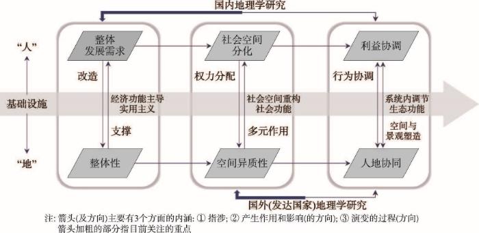
图1
国内外地理学中基础设施研究的核心框架
Fig. 1
The core framework of infrastructure studies in domestic/international geography
尽管如此,这种人地关系的理解却存在一定的局限性,比如将“人类”和“环境”视为一个整体和泛化的概念,忽略了人类社会和环境本身的异质性和多样化。这种认知显然低估了基础设施活动可能产生的社会影响,从而缺乏对基础设施社会属性的讨论。当然,这一领域在处于不同社会发展阶段的发达国家的人文地理学研究中得到了一定程度的拓展,对基础设施活动中涉及的“人”的社会空间分化以及“地”的空间异质性进行了广泛探讨(图1)。如前文提到基础设施暴力[47]这一概念,主要是指基础设施建设对于原有社会结构的破坏,从而加剧了社会不公的现象。事实上,这种基础设施暴力也会诱发社会抵抗运动,反过来在基础设施项目的设计和实施等环节产生影响[53],这就属于这一研究范畴比较典型的案例。
无论是处于发展阶段对基础设施经济功能的研究,还是处于后发展阶段对基础设施广泛社会属性的探讨,都依然遵循了一种“人”与“地”相对割裂的、静态的基础设施本体认知。然而,人类社会与资源环境并非孤立的节点或场域,而是一个浑然一体的系统,贯穿从改造自然、协调群体利益到促进人与自然和谐共处的全过程。因此,对基础设施涉及的人地关系进行分析,需要跳出静态的基础设施本体认知,从更加动态、多维、系统以及关系化的本体观来讨论基础设施如何对人地关系进行校正和调节(图1)。这种理念与传统的人地关系研究中将基础设施建设的对象和结果视为静态的、物化的和相对孤立的关系不同的是,它将基础设施及其涉及的相关要素都视为一个动态集合中的节点。这就意味着我们在关注基础设施及其地理影响的过程中,需要打破静态的基础设施本体观的桎梏,在人与物以及环境和谐共处、互为一体的认识论前提下,探讨基础设施如何参与到人地关系的协调过程中来,这也正是本文的核心要义之所在。
在构建了新的本体观基础上,地理学视角下的基础设施研究,本质上还是要塑造一种更有利于人类可持续发展的人地关系,以“人”为本,服务于“人”,是基础设施建设的内在必然,因此基于人类中心视角的研究仍然是该领域的核心议题。同时,在全球可持续发展的大背景下,资源与环境对人类社会的反馈与影响,成为人地关系中迫切需要解决的重大议题。从地球表层的自然与人文社会经济系统协调发展来看,超越人类中心主义、塑造人与自然和谐发展的人地关系,是未来基础设施建设面向全球可持续发展的另一个重大议题。这既是科学问题,也是发展哲学与价值观的问题。当然,需要强调的是,这里对人类中心和超越人类中心的界定并非是在人与超越人的要素之间人为地制造边界,而是跳出基础设施来讨论基础设施,从“跳出山界外”的视角对地理学学科视野中涉及的基础设施研究议题进行分类探讨。
3.2 地理学中基于人类中心视角的基础设施研究
基础设施终归是由人发起的以改造环境为目标的社会活动,人是其中的主导者。因此,地理学中的基础设施研究不应忽视其与生俱来的人文和社会属性,即以人类作为中心去探讨基础设施与人地关系的互塑作用。从这方面来讲,国内地理学重点关注的功能主义和实用主义导向的基础设施研究以及发达国家地理学重点关注的基础设施对社会空间的重塑等都属于地理学中基于人类中心视角的基础设施研究所关注的重点议题。
首先,基础设施最直接的目标是提升人类在特定空间范围内资源支配的能力,因此功能和经济属性是最基础的属性。从“人”通过基础设施改造“地”,从而实现人类社会整体发展需求这一人地互动过程来看,这一以“人”作为中心的互动过程依然是地理学中有关基础设施研究的核心议题,这项议题涉及两个方面且相互关联的研究内容:① 基础设施如何改造环境;② 经过基础设施改造的环境如何支撑人类社会系统的整体(经济)发展需求。因此,类似如何优化交通基础设施网络、布局工业基础设施系统及相关作用机制,都成为实现国民经济效益最大化需要考虑和研究的问题;此外,选择与哪些国家、哪些区域、哪些城市建立交通、油气和电讯等不同方面的基础设施互联互通网络以及其中涉及的人地互塑作用和机理,也成为一个国家实现其全球经济目标需要重点审视的问题。正如Apostolopoulou对“一带一路”倡议中中国企业主导的基础设施项目对区域经济活力恢复所带来的影响的讨论一样,通过雅典、科伦坡和伦敦几个港口基础设施的研究发现,基础设施重新定义了几所城市在全球经济网络中的区位,实现了区域和城市层面的空间修复,重新激活了它们的经济活力[54]。
其次,人类社会和环境都具有异质性。因此,地理学中以人类中心作为视角切入的基础设施研究应从更加细致的层面去关注基础设施活动与人类社会空间的互塑作用。概言之,基础设施并非建立在同质的社会基础上,社会有阶级、性别、种族、权力以及其它个体差异所呈现出的空间异质性,而基础设施正是在这种社会空间异质性的基础上进行空间再生产的。在全球、国家以及区域等不同尺度空间范围内,基础设施建设在某种程度上来说都改变了原有的空间结构。虽然不同群体都可能参与到基础设施活动的设计、分配以及使用过程中来,但终归是处于一种非均质状态,例如,基础设施设计初衷没有充分考虑各类群体的需求,而分配又受制于固化的社会结构等。就像Sabhlok[55]所关注的,道路是区域发展的重要基础,但道路在何处修筑的决策背后隐含着一系列的权力博弈。道路基础设施的空间不均严重加剧了沿线与非沿线地区的经济发展差距。反过来,基础设施的设计、分配和使用并不是孤立存在的,而是嵌入在复杂的经济、政治和文化网络之中,其背后所反映的价值规范都有可能塑造或重塑基础设施的价值和意义。在全球化背景下,基础设施不仅是工程项目,而且被赋予国家权力的隐喻,成为国家间围绕不同地缘利益展开争夺的对象[39];同理,城市基础设施的改造能增强地方社区的发展动力,但贫困社区却可能因重要基础设施受到绅士化冲击而产生反作用,产生激烈的抵抗[53]。正如Shaker[56]提出的“交通正义”概念所讨论的,边缘群体在日常出行中被排斥、歧视和骚扰充斥,愤怒、不适、焦虑和恐惧等情绪早已渗透到其公共交通体验之中,因此由边缘群体提议的交通再规划案例在微观政治实践中层出不穷。从这些角度来看,从人类社会空间的分化来看其权力差异如何作用于基础设施活动,以及基础设施活动的多元性如何反过来作用于社会空间重组是地理学在更加中、微观层面的基于人类中心主义视角的基础设施研究可以展开的话题。
3.3 地理学中超越人类中心视角的基础设施研究
地理学中以人类为中心的基础设施研究将“人”置于人地关系中的先决位置,却忽略了环境对人类社会系统的反噬。事实上,由于人类改造和利用自然超出其承载力而带来反噬的例子不胜枚举。例如,当面对超出自然承载力的基础设施干预时,自然的反噬作用将对人类社会资源或风险分配产生深刻影响[57];又如,现代超级基础设施不仅带来了全球范围内物品、人口的流动,也造成了全球跨区域物种的流动和重组,这种生物性重组可能带来灾难性的后果,如导致流行病、瘟疫等[58]。更为重要的是,在长期的人与自然互动过程中,自然也反过来对基础设施本身的意义产生了影响,甚至重新定义了基础设施。比较典型的例子是将自然甚至是生物(比如海狸[59])而非纯粹的技术工程视为基础设施,这打破了人与自然二元割裂、对立的人地关系认识论,将其融为一体,从本体上拓展了对基础设施的理解。
随着人类在改造和利用环境的过程中与环境系统之间的张力日益浮现,越来越多的学者开始关注人以外的自然(或者其他非人)要素在重塑人地关系中的作用。例如,Evans等考察了非洲象在人象冲突的政治生态以及塑造后殖民时期肯尼亚土地政治中的重要角色这一研究中发现,动物在塑造保护区等土地利用形态方面发挥着重要作用[60]。对于国内地理或者其他相关学科来说,这方面的反思主要体现在基础设施研究中对人地关系可持续发展的要求。比如,处于发展阶段的中国,许多基础设施建设活动仍迫切地需要以破坏资源环境作为代价。但是,中国人文地理学在这个阶段的研究却以可持续发展作为目标,将人地视为一个有机统一的系统,其中人作为自然系统的一部分去考虑,探索了调节人类环境系统和谐统一的科学途径,提出了努力建设生态文明的建议[61]。在基础设施建设的实践中,现在的项目建设均需做非常细致的环境影响评价;在生态文明建设过程中,开始重视水利设施等有利于增强生态与环境功能的基础设施建设;也开始重视对于污水处理等有利于降低生态环境影响的基础设施建设等,这些现象其实都是我们关注到的国内研究就可持续发展对基础设施提出的要求所产生的社会影响。
同样,欧美等发达国家的地理学在基础设施研究领域也出现了类似趋势。越来越多的西方人文地理研究开始关注基础设施活动的生态效应,就人类基础设施活动对地质结构破坏、土壤养分流失、水质严重下降、大气污染、全球气候变暖等产生的影响进行了分析和评估[62]。有的研究甚至提出了“生态廊道”等理念[59],尝试通过生态基础设施将人类社会系统和自然环境系统有机地整合起来。更为值的关注的是,西方人文地理学在理论层面也进行了许多创新尝试,一些新的概念和理论,诸如“超越人类地理学(more-than-human geography)”“非人类地理学(non-human geography)”以及“动物地理学(animal geographies)”等都以讨论人类社会系统以外的其他自然(非社会)因素在整合、重塑人类社会系统和自然环境系统之间的关系中的作用见长[63]。这些理论和可持续发展理论在本质上是相通的,都强调在关注基础设施如何协调人地关系方面,应该超越人类中心,将人地视为一个集合,去讨论如何在系统内部实现人地协调。
从这个意义来讲,虽然中国和西方处于不同发展阶段,国内外地理学关于基础设施的研究也呈现出不同特征,但是在这一研究领域讨论如何超越人类中心,将人类社会系统和自然环境系统视为一个有机且统一的系统,从而探究人类改造和利用自然环境的基础设施活动如何服从于人地系统的可持续发展这一终极研究思路来讲是殊途同归的。这也是未来地理学中的基础设施研究,尤其是基于超人类中心视角的基础设施地理学研究需要重点关注的议题。这意味着超越人类中心的基础设施地理学分析提倡在对人类活动对自然的影响进行评估的基础上进一步拓展,将基础设施活动视为一种协调人地关系的媒介,来探讨自然环境、植物和动物以及其它非人类物种对人类活动的空间反映、适应和协商,并对这个过程及其机制和效应进行深入分析。在这个过程中,生物和生态环境的地理模式如何通过基础设施这一媒介进行再调整、生物习性随着基础设施变化如何指导其空间行为、不同物种如何通过基础设施进行空间重组等这些超越人类中心的研究议题都值得关注。
4 讨论与展望
当下,全球正在掀起新一轮的基础设施建设浪潮,人类在不同尺度空间范围内的基础设施活动越来越频繁,基础设施作为人文地理学对空间资产化进行关注的一个焦点[64],正在成为重塑全球格局的关键要素。中国在其中扮演了重要作用,自“一带一路”倡议提出以来,中国已与沿线近200个国家和地区开发了6个经济走廊,建立了新的国际金融机构,提供了数千亿美元的对外投资,这些大都是以基础设施的形式开展的[65]。本文对地理学中既有的与基础设施研究相关的文献进行了梳理发现,国内外地理学中对基础设施的研究存在比较明显的学术边界:国内更加注重基础设施的功能属性,讨论其对于区域间资源配置的支配能力、效应,而国外更加关注基础设施所涉及的人地关系中“人”与“地”的异质性。本文认为这种学术边界是由社会发展阶段对基础设施的不同诉求所导致的,其本质上是一脉相承的。因此,在对地理学视角下国内外基础设施研究差异进行比较的基础上,本文跳出静态的基础设施本体认知,对基础设施涉及的人地关系进行了深入分析,从更加动态、多维、系统以及关系化的本体观来讨论基础设施如何对人地关系进行校正和调节,并探讨了这一系统基础设施本体认知背景下基础设施涉及的核心地理学议题。从学理上来说,本文整合了地理学中国内外基础设施研究的本体差异,为国内外地理学研究进行有效的对话构建了一个统一的概念框架和本体基础。
本文的价值不仅体现在理论层面,也表现在应用方面。比如,对基础设施先行背景下“走出去”战略过程中如何讲好中国故事来说,目前国内外地理学中关于基础设施研究存在的巨大范式差异,尚未能够提供有效且统一的话语基础。本文从地理学人地关系视角出发,对中外基础设施研究进行了比较和反思,认为有如下3个关键研究议题值得重点关注,可以为中国“走出去”语境下讲好中国(基础设施)故事提供重要的参考价值。
(1)考虑不同东道国发展阶段对基础设施投资的需求。“一带一路”所涉及的大多数国家都是发展中国家,具有发展的强烈需求,贸然超越这些国家的发展阶段去讨论基础设施的社会、生态属性是不现实的。因此,从功能属性主导的实用主义视角去讨论“一带一路”基础设施活动在支撑区域发展需求方面所扮演的重要作用是中国“走出去”战略背景下对基础设施进行研究的首要工作。近年来,中国的“走出去”活动是在全球经济紧缩的大背景下展开的,这也意味着中国的跨国基础设施活动可以重塑地方和社会的性质,建立对资本和贸易友好的金融和经济环境(尤其是经济走廊的打造),通过基础设施强化生产原料、剩余商品和劳动力的流动性以及地域重组的可能性来振兴经济,可以被视为全球空间重组最新的一个机遇[66]。从这个角度来看,中国跨国基础设施活动对不同尺度空间所产生的影响,包括在全球、国家、区域和城市等尺度上对空间结构、空间形态、区域联动和流通以及区域经济活力等所产生的影响及其机理,依然是未来地理学研究中对基础设施展开讨论的关键议题。
(2)对基础设施的社会属性进行广泛的研究。社会属性是目前国内地理学研究比较薄弱的一个环节,这对于在西方话语体系和国际舆论环境下,讲述中国跨国基础设施活动这一中国故事是不利的。国外研究认为基础设施涉及人类社会的多层维度,能够整合、重塑多尺度和跨尺度的权力结构。跨国基础设施活动不仅是一个连接国家间、区域间的社会技术工程,也深深地嵌套在国家政治经济竞争以及地缘想象之中。比如,“一带一路”涉及不同国家和地区在不同尺度上的资源和市场再分配问题,其中原本体现在生产关系和市场方面的空间异质性得到进一步的改变和重组,这可能会被理解成为一种“国家中心主义”形式的权力形式、资本扩张、资源掠夺以及文化输出,加剧沿线地区的负担,甚至转化成为为消极的国家认同和地缘想象的依据[67]。此外,基础设施也被视为空间暴力的来源,关注跨国基础设施活动过程可能存在的显性或隐性的基础设施暴力以及如何减缓这种暴力也是关键研究议题之一。比如,有学者发现南南合作的能源基础设施建成效益是基于不均等条件进行分配的,占据收益主体的全球南方城市能源生产一般依赖于非城市地区基础设施网络的传送运输,在乡村地区,随着大量土地被转变为供城市服务的基础设施用地,经济投资成效却始终难以扩散到城市以外的地区,乡村不仅面临失去土地的财政损失,同时也无法享有基础设施服务,导致农村人口利益遭受多重剥夺[68]。从这些角度来看,基础设施带来的隐性的、渐进的、累积的社会空间影响以及多元利益相关群体的公平和福祉也是未来地理学中基础设施研究需要重点关注却又容易被忽视的关键议题。
(3)从超越人类中心视角对基础设施如何在追求人类社会共同发展的同时又能够有效实现人地关系的协调这一关键议题进行开拓性分析。从前文分析来看,无论是东方语境下的对基础设施经济功能主导的实用主义研究,还是西方语境下的对基础设施广泛的社会属性的探讨,都没有将人类社会系统和自然环境系统有机地统一起来,视为一个浑然一体的集合。这对于中国地理学中日渐关注的基础设施研究来讲,无疑是一个与国际并轨、对话甚至是超越的机遇。在经历了以环境作为代价的痛苦发展阶段之后,中国提出了社会主义生态文明建设的总体方针,强调了人与自然和谐共处的人地观。这种人地合一观在跨国基础设施活动中是如何被践行和体现的,例如积极推进绿色丝绸之路建设、完善海外投资的生态环境影响评估和生态立法、积极参与生物多样性保护的实践以及环境保护的其他在地化实践等超越人类中心的研究议题,都是未来中国地理学中基础设施研究最具机遇的议题。
参考文献
Progress in research on the Belt and Road Initiative
DOI:10.11821/dlxb201804003
[本文引用: 1]

The Belt and Road Initiative (BRI) has changed from a China-based initiative to an international consensus, and is becoming a platform for a growing number of countries in the world to explore new international economic governance mechanisms. Such a great change along with impressive achievements of BRI development has attracted academic attention from almost all disciplines except basic sciences, giving rise to huge literature. This paper will first explore data from China Knowledge Resource Integrated Database to summarize the characteristics of literature on BRI in general, and then review progress in research on major BRI topics related to geography. The paper finds: (1) the number of Chinese papers on BRI increased by 21 times in three years, from 1012 in 2014 to 21216 in 2017; (2) these papers cover various BRI-related topics but most of them are macroscopic and very general studies of BRI with a taste of public voices, implying that quality papers with deep academic studies are demanded to support the BRI development; (3) more frequently discussed topics are China's outward foreign direct investment, facilities connection, "going out", globalization, global economic governance, community of shared destiny and internationalization of Renminbi; and (4) specific topics that are more deeply studied by geographers are connotation and discourse of BRI, geopolitical analysis of BRI, China-Europe Express Train, global strategic shipping pivot, model of China's outward foreign direct investment and overseas industrial parks, trade pattern and its impacts on economic growth of both China and its trade partners. Lastly, the paper suggests enhancing the discursive construction of BRI and studies of new BRI mechanisms as well as studies of countries involved in BRI, and promoting dialogues and collaborations between Chinese scholars and foreign scholars on BRI studies.
“一带一路”建设研究进展
DOI:10.11821/dlxb201804003
[本文引用: 1]
“一带一路”经历了从中国倡议到国际共识的巨大转变,正在成为世界上越来越多国家和政治领袖们探索全球经济治理新模式的平台。伴随这种转变以及“一带一路”建设所取得的成就,“一带一路”研究已经深入到除了基础科学领域外的几乎所有学科。本文根据中国知网(CNKI)数据分析了4年多来“一带一路”研究文献的特征,而后总结了与地理学密切相关的“一带一路”核心议题的研究进展。研究发现:① 自2014年以来“一带一路”研究发文量迅速上升,由2014年的1000多篇飙升到2017年的20000多篇;② 文献比较庞杂,以宏观性、战略性和一般性文献为主,舆论性很高,基于深入研究的高水平学术文献少,还不能很好地支撑“一带一路”建设;③ 对外直接投资、互联互通、“走出去”、全球化、全球治理、命运共同体、人民币国际化等得到的关注较多;④ 地理学在“一带一路”的战略内涵和理论构建、地缘政治经济分析、“中欧班列”、海上航运战略支点、海外投资模式、经贸格局及其经济影响、资源环境问题等方面研究较为深入。最后,本文呼吁加强“一带一路”的理论建构以及建设机制和国别研究,并积极开展中外学者之间“一带一路”研究对话以及合作研究。
A novel geographical research agenda on Silk Road urbanisation
DOI:10.1111/geoj.v187.4 URL [本文引用: 1]
The global infrastructure turn and urban practice
DOI:10.1080/08111146.2017.1284036 URL [本文引用: 1]
An exploration of significant development strategies of urban agglomeration in China
我国城市群重大发展战略问题探索
Tool-power: Water infrastructure as wellsprings of state power
DOI:10.1016/j.geoforum.2013.08.005 URL [本文引用: 1]
Critical infrastructures as sites of conflict over state legitimacy: The case of Hargeisa Airport in Somaliland, Northern Somalia
DOI:10.1016/j.geoforum.2021.06.019 URL [本文引用: 1]
Ripping the heart out of ancoats: Collective action to defend infrastructures of social reproduction against gentrification
DOI:10.1111/anti.2019.51.issue-2 URL [本文引用: 1]
Institutional-economic-cultural adaptability of overseas railway construction: A case study of Addis Ababa-Djibouti Railway
DOI:10.11821/dlxb202006006
[本文引用: 2]
The development of a country at a certain stage is an outcome of a long-term historical accumulation process, which forms a mutually adaptive state of development among the main national factors such as institution, economic, cultural and technological systems. And the technology transfer breaking through the original level will cause a disorder among the institutional-economic-cultural-technological systems (IECT system), and produce the frictional effect of technology-environment. This paper constructed a conceptual model on the complex system among the institution, economy, culture and technology, and analyzed its major features. Then, we simplified the above model into railway-institution-economic-cultural model (RIEC system) and probed the adaptive mechanism between railway and institutional-economic-cultural system. Furthermore, we explored the institutional-economic-cultural adaptability of the Addis Ababa-Djibouti Railway. This article insists that Ethiopia and Djibouti had not experienced the large-scale industrialization. As an electrified railway, the Addis Ababa-Djibouti Railway is a "spanning transfer" of the technology and there is a misplacement between this railway and the developing stage of Ethiopia and Djibouti. And the construction and operation of this railway brought out an obvious challenge for the institutional-economic-cultural development of these two countries, which resulted in the inadaptability of local institutional, economic and cultural system, and the unbalance of RIEC system. This study can provide a scientific guidance for China's enterprises to construct railways and spread China's railway standard in the world especially in the less-developed countries.
铁路技术跨越式转移的制度—经济—文化适应性: 基于亚吉铁路的实证分析
DOI:10.11821/dlxb202006006
[本文引用: 2]
国家在制度、经济、文化、技术等要素之间组成相互支撑、制衡、嵌套的平衡系统,而技术的跨越式转移将会引起系统的失衡,造成“技术—环境”摩擦效应。本文试图构建技术与制度、经济、文化平衡系统概念模型,进而凝练铁路—制度—经济—文化平衡系统模型,并以亚吉铁路为例,分析铁路技术跨越式转移与属地国制度—经济—文化系统的适应性。研究表明,埃塞俄比亚和吉布提仍处于农牧业阶段,而亚吉铁路作为电气化铁路技术,属于“跨越式”的技术转移,脱离了属地国的既有发展基础,造成铁路技术与制度、经济、文化的不适应性。本文的研究结论可以为中国企业在全球尤其是欠发达国家承担铁路建设运维与推广中国铁路技术标准提供理论指导。
Embedded technology transfer from an institutional and cultural perspective: A case study of Mombasa-Nairobi standard gauge railway
DOI:10.11821/dlxb202006004
[本文引用: 2]
Since the Belt and Road Initiative (BRI) was proposed, the pace of projects investment and construction has been accelerated, which accumulated much experience in the going-out strategy in the context of BRI. Modern railway projects are characterized by "natural monopoly", as well as huge investment and extensive geographical coverage. Moreover, their construction is a typical transformative project, which embedded the necessary institution and culture. The countries along the Silk Road are characterized by weak institutional construction, lack of regulatory system, and underdeveloped industrial civilization, therefore they cannot operate and manage the railway system. In this context, all links, including financing, design, construction, and operation, should be considered in the going-out process of China's railway system. The transfer subject is the technology-institution-culture nexus which takes railway technology as the core. In other words, to achieve railway technology transfer successfully, the host countries should offer rational institutional guarantee and cultural adaptation. Besides, the technical standard of railway construction, management mode, and industry chain in the process of railway operation and maintenance need to be localized. Mombasa-Nairobi standard gauge railway is a successful going-out case of China's railway technology. Learning from the case, this paper proposed the concept of "embedded technology transfer" and constructed the theoretical model of technology-institution-culture nexus transfer. The results can provide references for the transfer of transformative projects or technologies between countries with different institutions and cultures.
制度与文化对嵌入式技术海外转移的影响: 以蒙内铁路为例
DOI:10.11821/dlxb202006004
[本文引用: 2]
中国与东道国之间制度与文化上的差异,已经成为中国企业“走出去”关注的重点,也是推动“一带一路”建设向高质量发展转变必须考虑的重要因素。现代化铁路项目具有“自然垄断”、投资大、涉及地域广的特点,其建设对运营制度与文化的依赖性强,属于一种典型的变革性项目和嵌入式技术转移。“一带一路”沿线国家制度建设相对薄弱,与中国文化差异较大,且往往不具备铁路运营技术与能力,因此中国铁路在“走出去”的过程中,必须从设计—建设—运营乃至投融资进行全链条考虑,并将铁路项目作为“技术—制度—文化”复合体进行培育,即通过制度保障、文化相互适应以及技术标准、管理模式、产业链条的属地化管理,来保障项目的成功运营。蒙内铁路是中国铁路“走出去”较为成功的案例,本文通过实地调研,总结了“技术—制度—文化”复合体海外发展模式,从而为推动海外项目建设与运营成功、“一带一路”建设向高质量发展提供借鉴意义。
The politics and poetics of infrastructure
DOI:10.1146/anthro.2013.42.issue-1 URL [本文引用: 1]
Spatial pattern of railway geo-system and development menchanism from the view of gauge: A case study of Eurasia
DOI:10.11821/dlxb202008012
[本文引用: 1]
The railway is an important geospatial element as well as an indispensable feature of a nation's infrastructure. It is a material element of a nation's transport network, and it also has social, national defense, military, and even political attributes. Therefore, it has a profound impact on the geographical system, which intensifies the spatial differentiation and reconstruction of the terrestrial system. This paper defines the conceptual connotation and basic characteristics of the railway ecosystem, and analyses the railway network structure, including its gauge structure and national distribution. Secondly, taking Eurasia as the research area, we explore the geographical differentiation of the Eurasian railway network, including gauge differences, the rail system, and the organization of the transport system. Thirdly, this paper investigates the dynamic mechanisms leading to the formation of the Eurasian railway geo-system, with a particular focus on technology dissemination, path dependence, geopolitics, and national defense. Finally, a geographic model of the track gauges of railways in Eurasia is developed. It is found that a complex pattern of railway gauge differences has been formed in Eurasia. Among the numerous railway regulations, three main types of gauge are identified, including 1520 mm, 1435 mm, and 1067 mm. Considerable variation in the coverage of different track gauges is apparent, which provides a physical and technological basis for railway system differentiation and network fragmentation. We find that eight geo-systems in continents of Europe and Asia are strengthened, which divide the Eurasian continent into discrete regions. These differences that geo-systems extend across different numbers of countries, have led to the formation of distinct geopolitical relationships, with five separate track gauge expansion modes, and a geographical confrontation between the 1435 space and 1520 space track gauge areas.
基于轨距的亚欧大陆铁路地缘系统格局及形成机理
DOI:10.11821/dlxb202008012
[本文引用: 1]
铁路是重要的地理空间要素和基础设施类型,是在运输属性基础上不断拓展而包含社会、国防军事乃至政治内涵的物质要素,对地理系统具有分异和重塑功能。本文界定了铁路地缘系统的概念与基本特征,并以亚欧大陆为研究单元,分析其铁路轨距结构,探讨了其地缘系统分异格局,包括轨距差异、路轨系统、运输组织系统等;考察了亚欧铁路地缘系统的形成机理,重点从技术传播与路径依赖、地缘政治与国防军事、殖民扩张与殖民统治等角度进行揭示;最后,总结了亚欧大陆铁路轨距技术的地缘传播模式。研究发现亚欧大陆形成了复杂的铁路轨距分异格局,但主流轨距是1520 mm、1435 mm和1067 mm,其覆盖里程规模与空间范围、地理区位均形成明显分异,成为铁路地缘系统形成分异、网络形成割裂的物理基础和技术源头。亚欧大陆形成了8个铁路地缘系统,分别割据亚欧大陆的不同地区,覆盖不同数量的国家和空间范围,形成了不同的地缘关系,尤其是产生了“1435空间”和“1520空间”的地缘对抗,并形成了5种铁路轨距传播的地缘模式。
China railway and regional economic development under market economy
市场经济下中国铁路与区域经济发展
On the influence of railway trunk lines on the economic development of the areas along the line
论铁路干线对沿线地区经济开发的影响
Spatial impact of airport facilities' NIMBY effect on residential prices: A case study of Beijing Capital International Airport
DOI:10.11821/dlyj020210092
[本文引用: 1]
In the process of urban development, the contradiction between the construction and operation of large-scale public infrastructure and the optimization and improvement of residential space quality has become increasingly prominent. With the continuous urban renewal, it has become the top priority of urban planning and construction to realize the win-win goal of efficient and rational use of planned land and livable and harmonious life of the people. The Beijing Capital International Airport has negative effects on surrounding residents due to its electromagnetic radiation, noise and solid pollution. As a result, it has been subject to constant complaints from residents and long-term petitions for decision. Due to the obvious negative externalities of airport facilities, its NIMBY (Not In My Backyard) has an impact on the prices of surrounding houses. This research uses the Hedonic Price Model (HPM) to analyze the impact of "distance from NIMBY facilities "on the housing price of Beijing Capital International Airport, characterizes the measurement of the spatial effects of NIMBY facilities under the influence of different factors, and analyzes the range of influence on residential prices of Beijing Capital International Airport radius. The main research conclusions are as follows: (1) The capital airport facilities have a negative impact on the price of surrounding houses. Within a certain range, for every 1% decrease in the distance to airport facilities, the price of residential houses will decrease by 0.586% on average. The influence of different factors is also different. Among them, the noise level also has a greater influence on the price of housing, with an influence coefficient of 2.145. The distance between the residence and the subway station and bus station also has a greater impact on its own price. (2) The spatial impact of airport facilities on residential prices is 10 km, and its spatial effects show a weakening trend as the "distance from the airport risk source" increases. In addition, there are 149 communities within the affected area, 83.2% of which are located in Shunyi District, and the number of affected households is approximately 130,000. (3) The spatial influence of airport facilities on NIMBY effect has different directions. The areas located to the west and south of the airport have an overall greater impact on surrounding residential prices than the areas located to the north and east of the airport.
机场设施邻避效应对北京市住宅价格空间影响研究: 以北京首都国际机场为例
DOI:10.11821/dlyj020210092
[本文引用: 1]
城市发展过程中,大型公共基础设施的建设运营与居民居住空间品质的优化提升之间的矛盾日益突出。随着城市更新的不断深入,实现规划用地高效合理利用与人民生活宜居和谐的双赢目标成为城市规划建设的重中之重。由于机场设施存在较为明显的负向外部性,其邻避效应对周围住宅价格产生影响。本研究对首都国际机场运用特征价格模型分析“同邻避设施的距离”对住宅价格的影响,表征了在不同要素影响下邻避设施空间效应的量度,同时分析得出其对住宅价格的影响范围半径。主要研究结论如下:① 首都机场设施对周边住宅价格存在负面影响。在一定范围内,到机场设施的距离每减少1%,住宅价格平均降低0.586%。不同要素的影响力也存在差异。② 机场设施对住宅价格的空间影响范围为10 km,其空间效应随“同机场风险源距离”的增加而表现出减弱的趋势。此外,影响范围内的小区有149个,83.2%的小区分布在顺义区,受影响的户数约为13万。③ 机场设施的邻避效应空间影响存在方向异性,位于机场西部和南部的区域对周边住宅价格的影响范围整体大于位于机场北部和东部的区域。
Spatial agglomeration of design creative talents and its driving factors: Based on the perspective of urban amenities
DOI:10.13249/j.cnki.sgs.2021.09.004
[本文引用: 1]
Creative talents are the new dynamics to urban and regional economic development. However, limited attention was paid to the spatial agglomeration mechanism and driving factors of creative talents. Based on the theory of urban amenities, the paper establishes an index system of urban amenities to the spatial agglomeration of creative talents in design sectors in China. An extensive dataset with over 3 million designers registered in the online platform zcool.com was adopted as the sample for this study. It aims to examine the spatiality of China’s creative talents and its association with urban amenities for cultural production. Using the quantitative methods such as location quotient, geographic concentration index, and the negative binomial regression method, we investigate the characteristics and mechanism of the spatial concentration of Chinese creative designers. The results suggest that: First, the distribution of creative designers shows a significant spatial agglomeration. First-tier cities like Beijing are the most dominated, but emerging cities such as Hangzhou, Changsha, Wuhan, and Zhengzhou are also well-performed, even better than some first-tier cities. Second, amenity-based approach has a strong explanatory power in explaining the agglomeration of Chinese design creative talents. The cultural environment, educational environment, and natural environment are the core factors that affect the agglomeration of design creative talents. Third, this study echoes with some conclusions of the creative class theory. Cultural infrastructures, cultural heritages, cultural tourism, high-quality human capital, warm climate, and good air quality were essential to enhance the city’s attractiveness to creative talents. Simultaneously, it is found that scientific research investment has a significant crowding-out effect on the accumulation of creative talents. The amenity factors of the living environment that were emphasized by Western scholars have a limited impact on agglomeration of creative talents. In conclusion, this research adopted a more inclusive urban amenity theory, and proved that urban amenities matter in the process of concertation of creative designers. It also provides a reference for local governments to promote their brain gain policy for creative talents.
设计创意人才的空间集聚及其影响机理研究: 基于城市舒适性视角
DOI:10.13249/j.cnki.sgs.2021.09.004
[本文引用: 1]
从城市舒适性理论出发,系统梳理了创意人才及其空间集聚过程的相关文献,构建了驱动中国设计创意人才空间集聚的城市舒适性指标体系,通过大数据方法从国内设计师社交平台站酷网获取设计创意人才的属性数据,运用地理集中指数、区位熵、负二项回归方法,深入剖析了中国设计创意人才的空间集聚特征与机理。研究表明:① 中国设计创意人才及其创作在空间上呈现出显著的集聚现象,以北京为主的一线城市最为集中,但杭州、长沙、武汉、郑州这些新兴城市也表现良好,甚至超过部分一线城市;② 城市舒适性理论在解释中国设计创意人才空间集聚时具有很强的解释力,其中文化环境、教育环境和自然环境是影响设计创意人才空间集聚的核心因素;③ 证实了西方创意阶层理论的部分结论,发现文化基础设施、文化遗产、文化旅游、高素质人力资本、温暖的气候与良好的空气质量是提升城市对创意人才吸引力的重要因子,同时发现科研投入对设计创意人才集聚具有明显挤出效应,并且西方学者普遍强调的生活环境舒适性因子对设计创意人才影响有限。为深入理解创意人才的空间过程及其影响机理提供了详实的实证案例,为地方政府改善城市创意环境提供了参考依据。
An exploration on water city model based on landscape infrastructure: Taking Shengze town in Wujiang district of Suzhou city as an example
基于景观基础设施的水都市模式初探: 以苏州吴江盛泽为例
Impact of public transportation infrastructure on employment of the low-income group in Urumqi
DOI:10.18306/dlkxjz.2020.01.011
[本文引用: 1]
Western cities in China experience large-scale, rapid, and vast-invested transport infrastructure construction, which makes it particularly important to evaluate the social economic impacts of these projects. Based on trip survey data in Urumqi in 2014 and multivariate linear regression and multinomial Logit regression model with cross variables, this study explored the impact of bus rapid transit system (BRT) on job satisfaction. The results show that measured by commuting time, employment accessibility levels are lower for the low-income group, the male, property owners, and private car drivers, while accessibility levels are higher for commuters with shorter distance to BRT stops. In terms of job satisfaction, the low-income people are likely to report lower level of job satisfaction, while those with shorter distance to BRT stop and private car drivers are likely to report higher job satisfaction. It also shows that shorter time commuters do not necessarily report higher level of job satisfaction. These results indicate that overall public transport infrastructure has a positive promoting effect on both employment accessibility and job satisfaction, but the differential impacts of individual attributes also cannot be neglected. The policy implication of this study lies in helping with making the public policy to improve employment accessibility and job satisfaction of the low-income group of urban residents, which will further promote local employment stability and regional economy growth.
乌鲁木齐公共交通基础设施对低收入群体就业的影响研究
DOI:10.18306/dlkxjz.2020.01.011
[本文引用: 1]
中国西部城市在大规模、快速度和高投资的交通基础设施推进的同时,审视其建设的社会经济效益就显得尤为重要。尤其对于城市低收入群体来说,公共交通基础设施投入是否能对提升就业水平、提升整体生活品质产生积极作用,值得规划者和决策者关注。论文基于乌鲁木齐2014年居民交通出行调查数据,采用带有交叉变量的多元线性回归和多元Logit回归方法,考察快速公交(Bus Rapid Transit, BRT)对于提升低收入群体就业可达性和通勤满意度的影响。分析结果显示:在就业可达性方面,低收入、男性和拥有住房产权者的通勤时间更长,距离BRT车站越近则通勤时间更短,私家车出行的通勤时间更长;在通勤满意度方面,低收入群体的通勤满意度水平更低,距离BRT车站近、选择私家车出行的通勤满意度水平更高。分析也表明,通勤时间短,通勤满意度水平不一定就高。这些研究结果表明,整体上公共交通基础设施建设对于提升就业可达性和满意度有着积极的带动作用,但个体经济社会属性的差异影响也不可忽视。研究乌鲁木齐公共交通基础设施对就业可达性和满意度的影响,有助于帮助西部城市制定提升低收入群体整体就业水平的公共政策,尤其对于促进地方就业稳定和带动区域经济发展有重要意义。
Seasonal and spatiotemporal differences in the public transport-based mobility of elderly population: A case study of Wuhu city in Anhui province
DOI:10.18306/dlkxjz.2021.02.010
[本文引用: 1]
Mobility is an important factor that influences the quality of life of elderly population. Improving the mobility of the elderly is an important means to prolong their independent living time and thereby reduce the cost of elderly care of the society. Public transport is the most important transportation mode for the Chinese elderly population when they travel for a long distance. Despite many studies focusing on the elderly's mobility through walking, insufficient attention has been paid to the public transport-based mobility. This study took Wuhu City as the study area and examined the pattern of the elderly's public transport-based mobility using smart card data. In particular, three parameters—movement radius, movement frequency, and movement entropy—were first used to quantify elderly's public transport-based mobility. Spatial autocorrelation methods were applied to analyze how elderly's public transport-based mobility patterns are spatially aggregated in different seasons and how the patterns vary under seasonal changes. The results show that: 1) Elderly's public transport-based mobility shows an obvious spatial aggregation pattern. The clusters are circularly distributed across the city, with the city center, the periphery of the city center, and the edge of the city showing different aggregation characteristics. Specifically, the radius of movement shows a crossed distribution of cold spots and hot spots from the city center to the outskirts of the city; the movement frequency and movement entropy show a wide range of hot spots in the city center and the periphery of the city center, while the cold spots are distributed in groups on the edge of the city. The agglomeration characteristics did not show structural changes in different seasons, but there were differences in the location and range of agglomeration. 2) The spatiotemporal differentiation of the elderly's public transport-based mobility is compound. Although the overall influence of seasonal factors on the mobility of the elderly population is weak, there is a significant concentration in specific places. However, the sensitivity of different urban spaces to seasonal change is different, and it mainly increases from the city center outward. The study enriches elderly mobility research by developing an understanding on public transport-related mobility behavior of the elderly, and by exploring the spatiotemporal differentiations of public transport-based mobility across seasons. Empirically, this study can shed light on planning strategies and policy recommendations for developing elderly-friendly cities.
老年人公交移动性的季节时空分异特征研究: 以安徽省芜湖市为例
DOI:10.18306/dlkxjz.2021.02.010
[本文引用: 1]
移动性是老年人生活质量的重要影响因素,提高老年人的移动性是延长老年人独立生活时间,从而减小社会养老成本的重要手段。公共交通是中国老年人较长距离出行的最主要交通方式,但已有研究对公交移动性的关注较少。论文从季节时空分异的角度出发,利用安徽省芜湖市智能公交卡数据,分析不同季节老年人公交移动性静态空间集聚特征以及季节变化条件下移动性变化值的空间集聚特征。结果表明:① 老年人公交移动性空间集聚明显,呈现圈层式分布的特征。不同季节、不同移动性指标在城市中心、城市中心外围和城市边缘的集聚现象存在较大差异。② 老年人公交移动性的时空分异现象是复合的,不同城市空间对季节变化的敏感程度存在差异,主要呈现出从城市中心向外递增的趋势。研究公交移动性的季节时空分异现象可以为老年友好型城市的规划建设提供更加适当的规划和灵活的政策建议。
Imbalance analysis of rural infrastructure construction in China
DOI:10.13249/j.cnki.sgs.2010.06.839
[本文引用: 1]
China's economic development has entered a new stage of the industry promoting agriculture and city driving town. The China government has established a human-oriented development idea and is building a harmonious society to promote regional development. The infrastructure construction in rural areas plays a key role in protecting the rural production and life, but also is important for spiritual needs of rural residents and health needs. Rural infrastructure construction can expand living space of rural residents, bring out resources sharing and optimize the villagers living environment. The paper makes an infrastructure imbalance index model, and analyzed the level of infrastructure construction in the rural area of China's provinces contrast to population in village, area of village, GDP, fixed asset investment and rural investment. The results show that it is different in reigns about infrastructure investment, and the level of rural infrastructure and supply is not absolute high in some economically developed areas. The lack of total investment on infrastructure and the improper use of existing construction funds, it is just a key cause which led to a low level of the rural infrastructure supporting and construction conditions in China. At the same time, the scattered layout villages led to a low construction. On the basis of the construction of rural imbalance in regional infrastructure, the paper analyzed the reasons, referred some experience of rural infrastructure construction abroad, and proposed some suggestions to promote construction of rural infrastructure in China. The suggestions are 1) to strengthen the government's important role in the infrastructure construction of rural areas, to divide the properties of rural infrastructure, and to determine the part of public goods types of infrastructure; 2) to clear the policy focus on supply and services about rural infrastructure, actively to promote the key technology of infrastructure construction and services, and so on.
中国农村基础设施建设投入不平衡性研究
The influence of China-Europe Express on the production system of enterprises: A case study of TCL Poland Plant
中欧班列对企业生产组织方式的影响: 以TCL波兰工厂为例
DOI:10.11821/dlxb202006005
[本文引用: 2]
“一带一路”倡议的实施和中欧班列开通频次的增加带动了“一带一路”沿线企业生产组织方式的变化。以TCL波兰工厂为例,深入剖析其传统的生产组织方式和现有生产组织方式的特征及二者的区别,在此基础上系统论述了中欧班列对其现有生产组织方式的影响机制及作用方式。主要结论为:① 中欧班列对TCL波兰工厂现有生产组织方式产生了深刻影响,主要表现在:原料配送时间成本降低、供应链时长缩短;原材料的“零库存”效应;市场响应能力和效益的提升;生产更加准时化、精益化,产品品质和多样化程度提升等方面。② 在中欧班列准时化跨国运输的支撑下,TCL波兰工厂摒弃传统的以“刚性大规模生产”为主的福特制生产组织方式,吸收丰田制的精髓,形成了一种特有的生产组织方式——“全球流动的即时生产”。③ TCL波兰工厂现有的生产组织方式与传统的生产组织方式有明显区别,体现在原材料的运输方式及仓储方式的变化、生产线的变化、生产方式及质量检测组织的变化等方面。
China's international aviation transport to the Belt and Road Initiative area
DOI:10.11820/dlkxjz.2015.05.003
[本文引用: 1]
The Belt and Road Initiative aims to promote the connectivity of Asian, European, and African continents and adjacent seas and establish and strengthen partnerships among the countries along the Belt and Road Initiative area. The construction of international air transport network and land transport and maritime shipping corridors constitutes the three basic parts of transportation infrastructure and connectivity. This article employs the OAG (formerly Official Airline Guide) flight schedule data of 2014 to first analyze the spatial pattern of international air linkages between China and the other 64 countries in the Belt and Road Initiative area, and then identify China's international hub airports and sub-regional hubs based on the graph theory model. The results indicate that: (1) the coverage and intensity of international air passenger linkages is broader and higher than that of air cargo linkages. China's international air passenger linkages mainly focus on Thailand, Russia, and Singapore; while cargo linkages are primarily with Russia; (2) both the international air and cargo linkages show the "hub-spoke" and "point to point" patterns; (3) among the domestic airports, international air linkages are concentrated in only a few. Shanghai, Beijing, and Guangzhou are identified as the international air passenger hubs and Shanghai as the international cargo hub to the Belt and Road Initiative area.
“一带一路”与中国对外航空运输联系
DOI:10.11820/dlkxjz.2015.05.003
[本文引用: 1]
基础设施互联互通是降低贸易成本、增强国际联系、构建“一带一路”的基本条件。建设国际航空网络与陆路运输通道、海上航运通道,共同组成“一带一路”交通基础设施互联互通的基础。基于2014年的OAG计划数据,本文重点分析了中国与“一带一路”沿线国家的国际航空运输联系空间格局,并运用枢纽度模型识别国际航空枢纽。研究表明:①中国与“一带一路”沿线国家的航空客运联系广度和强度均高于货运,其中国际客运联系集中在泰国、俄罗斯和新加坡等国,而国际货运联系则主要集中在俄罗斯;②中国对外航空网络格局总体上表现为“轴—辐”与“点—点”模式并存;③上海、北京和广州为中国面向“一带一路”沿线国家的国际航空客运枢纽机场,上海同时还是国际航空货运枢纽。
Spatial change of China's investment pattern for overseas ports and its mechanism
DOI:10.18306/dlkxjz.2019.07.003
[本文引用: 1]
Along with the global strategy written into national strategy in 2000 and the Belt and Road Initiative proposed in 2013, China is accelerating the pace of investment for overseas ports. This study constructed a data base of examples of overseas ports investment by Chinese enterprises from 1978 to date, analyzed the spatial change of investment pattern on a global level, and clarified the features and pathway for Chinese enterprises entering overseas ports from the aspects of regional structure, participants, ownership change, and so on. It also examined the main entry patterns of overseas ports, internal relationship between different entry patterns, and correlation and shift between different patterns. Finally this article discussed the development mechanism of China's overseas port investment based on, in progression, why Chinese enterprises went global, why these enterprises invested where they did, and why these enterprises chose certain pattern. The results show that: The process of Chinese investment for overseas pworts can be divided into five development stages—before 2000, these overseas ports scarcely distributed in North Africa; from 2000 to 2008 China's investment for overseas ports tended to distribute in its surrounding areas; from 2009 to 2012 ports distribution turned to a global spread; from 2013 to 2016 overseas ports tended to concentrate as guided by the opening strategy; since 2007 ports distribution has remained overall stable. The changing process of distribution reflects three features: 1) Country distribution is dispersed, while these ports assemble significantly in Northwest European and Mediterranean at the navigation area scale. 2) The investors include large shipping enterprises, wharf operators, and infrastructure enterprises, among which the core enterprises for overseas ports' stock acquisition include China Ocean Shipping (Group) Company and China Merchants Steamship Company, and the core enterprise for overseas ports' infrastructure construction is China Harbour Engineering. 3) The number of overseas ports invested through stock acquisition began to increase rapidly since 2013 and as the investment process constantly deepening, overseas ports investment changed from equity participation to holding. Overseas ports entry patterns include infrastructure project construction, transfer of port managerial authority, acquisition of port's stock, and port management export. The influencing factors for overseas ports investment can be summarized as national economic development context, key opening-up strategy, global shipping pattern, spatial substitution, and enterprise self-development demand. Leading factors and their functions changed at different spatial scales and stages of development.
中国海外港口投资格局的空间演化及其机理
DOI:10.18306/dlkxjz.2019.07.003
[本文引用: 1]
伴随着2000年“走出去”写入国家战略和2013年“一带一路”合作倡议提出,中国正在不断加快海外港口投资的步伐。论文构建了中国企业海外港口投资案例的数据库,分析了1978年至今中国海外港口投资格局在全球范围的空间演化过程,并从地域结构、参与主体、股权变化等多个方面阐明了中国企业进入海外港口的特征与路径,总结了企业进入海外港口的主要模式,进一步探索了进入模式之间的内在关系,最后基于为什么“走出去”、为什么在这里布局、为什么选择这种模式3个递进的过程探讨了中国海外港口投资的发展机理。研究表明:中国海外港口投资的空间格局经历了零星分布、就近布局、全球扩散、局部集聚和总体稳定5个发展阶段,总体上集中布局于西北欧和地中海航区,投资主体包括大型航运企业、码头运营商和基建企业,海外港口投资的目标从参股转为控股。海外港口进入模式包括基础设施项目承建、港口经营权转让、港口股权收购和码头管理输出4种,进入模式具有交错演化的特点。中国企业进入海外港口的内在动因可以总结为国家经济发展环境、重大对外开放战略、全球航运格局和地理替代性和企业自身发展需求。
Theorizing the construction of the Belt and Road Initiative: Based on institutional and cultural perspectives
DOI:10.11821/dlxb202006003
[本文引用: 2]
Promoting the construction of the Belt and Road initiative (BRI) towards a new stage of high-quality development raises new subjects for academic research, which demands in-depth study of existing BRI projects, summarizing experiences and lessons and theorizing construction models to guide future development. Research in the field of economic geography focused on outward foreign direct investment (FDI) of Chinese firms, but BRI construction is much broader in scope, consisting of not only FDI projects but also China-financed projects and emerging mixed projects. Case studies of BRI projects have shown that significant cultural and institutional difference between China and host country is the factor that tends to be ignored by Chinese firms in the "going global" efforts. Thus, revisiting the institutional and cultural turn in economic geography and employing its research framework to analyze BRI projects and summarize their construction models may contribute to the development of both economic geography and BRI. This article will first briefly review the background and research trends of the institutional and cultural turn; then summarize three major construction models of BRI projects, namely EPC (Engineering Procurement Construction)-based, concession-based and FDI models; finally draw on the institutional and cultural turn to classify BRI projects according to two indicators of "Breadth and Depth of Territorial Embeddedness" and "Destructive Effects of Technology and Project" into four types, i.e. transformative, supportive and ordinary projects as well as industrial parks. Different institutional and cultural sensitivity can be identified for each type of projects. The preliminary theorization proposed in this article may offer a potential framework for future research on BRI construction.
“一带一路”建设模式研究: 基于制度与文化视角
DOI:10.11821/dlxb202006003
[本文引用: 2]
推动“一带一路”建设向高质量发展转变,对学术界提出了新命题,需要对已有建设模式和建设项目进行深入剖析,总结经验和教训,提出对“一带一路”建设具有指导意义的理论知识。以往地理学主要关注企业对外直接投资,而“一带一路”建设项目涉及的范畴要大得多,既包括中国的直接投资,也包括中国提供融资并承建的项目,还包括一些新兴的混合项目。已经进行的“一带一路”建设案例研究表明,中国企业“走出去”比较容易忽视的因素是中国与东道国之间在制度和文化上的差异。利用“制度和文化转向”研究思路来剖析“一带一路”建设项目,总结其建设模式,对于经济地理学的发展以及指导“一带一路”建设都具有重要意义。本文首先简要回顾了“制度和文化转向”出现的背景以及主要研究脉络;而后总结了“一带一路”建设项目的主要形式,提出了基于工程总承包(EPC)、基于特许经营和企业直接投资三大类建设模式;最后借鉴“制度和文化转向”的研究技巧,从“地域嵌入的广度和深度”和“技术及项目的‘破坏性’”两个维度,将“一带一路”建设项目分为变革性项目、支撑性项目、一般性项目和海外经贸合作园区4种类型,用以识别它们的制度和文化敏感性,并举例进行了说明。本文提出的分析框架为进行“一带一路”建设案例研究提供了一个思考方向。
Impact of infrastructure investment on non-infrastructure investment
基础设施投资对社会其他部门投资影响效应
Regional development and infrastructure construction in the Yellow River Delta
黄河三角洲区域开发与基础设施建设
Study on the evaluation of coordinated development of infrastructure and regional economic system
基础设施与区域经济系统协调发展分析
Transport infrastructure and the development of old industrial bases of northeast China
交通基础设施与东北老工业基地形成与发展: Var模型的研究
Relationship between infrastructure and socioeconomic development in Beijing
DOI:10.18306/dlkxjz.2016.04.006
[本文引用: 1]
Infrastructure has positive spillover effects on economic development. This study took Beijing as a research area and measured the direct and indirect contribution of infrastructure on economic growth, input-output relationships between infrastructure sectors and other economic sectors, as well as the coordination degrees of infrastructure with socioeconomic development level. This study indicates that: (1) the average rate of contribution of infrastructure to economic growth during 1978-2014 was about 34.9% in Beijing. In 1985-1990, 1990-1995, and 1995-2000, the contribution rates reached 45%. With regard to direct contribution, that is, the share of value-added of infrastructure sector in GDP, the postal-telecommunication infrastructure had the highest direct contribution, which accounted for 9% of GDP. This was followed by transportation, energy, and water-related sectors; (2) transportation and energy sectors had relatively high induction coefficients, indicating that the growth of other economic sectors increased the demand for these two infrastructure sectors, and hence drove their growth. It also reflects that these two infrastructure sectors were mostly demanded by other economic sectors and tended to have restriction effects on economic development, thus required to be constructed in advance; (3) infrastructure development in Beijing lagged behind the city’s socioeconomic development, especially for the water-related infrastructure, which is still the weakest of all infrastructure sectors and has the lowest coordination degree with the socioeconomic development level, despite that it has gradually improved. On the other hand, transportation, energy, and postal-telecommunication sectors have recently reached a highly coordinated state with socioeconomic development. Among them, the postal-telecommunication sector has developed with the most impressive rate. To conclude, the coordination degree of infrastructure and socioeconomic development in Beijing has entered a moderately coordinated stage since 2010.
北京市基础设施与经济社会发展关系
DOI:10.18306/dlkxjz.2016.04.006
[本文引用: 1]
基础设施对城市与区域经济社会发展具有正的溢出效应。本文以北京市为例,分别测度了北京市基础设施对经济增长的贡献率,基础设施部门对其他经济部门的关联关系,以及基础设施与经济社会发展水平的协调度。研究发现:①1978-2014年,北京市基础设施对经济增长的平均贡献率为34.9%,其中“七五”“八五”和“九五”时期基础设施建设提速,其贡献率高达45%左右;从各基础设施对GDP的狭义贡献度来看,邮电基础设施所创造的GDP最高,占到全市GDP的9%以上,往下依次为交通、能源和水务部门;②交通和能源部门的感应度系数较高,说明其他经济部门的增长将增加对该基础设施部门的需求,进而带动后者的增长,同时也意味着该基础设施部门易对经济发展产生制约作用,需要适度超前建设;③北京市基础设施发展水平相对滞后于经济社会发展,尤其是水务基础设施,虽然在波动中有所改善,但仍然是基础设施发展的短板,与经济社会的协调发展度最低。
Transport infrastructure and urban agglomeration integration: A case study of Chang-Zhu-Tan urban agglomeration
交通基础设施建设与城市群一体化发展: 以长株潭“3+5”城市群为例
Development mechanism and model construction of TOD for Chinese cities
DOI:10.11820/dlkxjz.2013.10.005
[本文引用: 1]
The relationships among urban transportation, land use and urban spatial structure are always the key topics in the studies of urban geography, urban planning and urban transportation. With the emergence of the issues such as urban sprawl, low efficiency of land use and traffic jam, it has become more and more important to study how to coordinate land use and urban transport in the planning of city development. As we all know, public transportation is not only one of the elements of urban lives, but also a driving force of urban spatial devolvement. TOD (Transit Oriented Development) is an urban development model under the guidance of New Urbanism, which emphasize the innovation of transport technology and the recognition of humans themselves. TOD integrates a mass transit system into the urban spatial structure, i.e., residential areas and commercial areas, at the macro-level, and neighborhoods develop around the transit stations or stops at the micro-level. TOD encourages high density development in an appropriate scale, mixed land use, comfortable environment for pedestrians and a good public transit system, to harmonize land use and transport, and finally enables the urban spatial structure to develop compactly and orderly. This paper analyzes TOD's mechanism on urban land use and urban spatial structure, and has found that TOD plays an important role in urban land use by influencing land use density, land use structure, and land value. Meanwhile, TOD influences the urban spatial structure by unique road structures, urban scale and urban spatial distribution. Further study indicates that the construction of mass transit makes the curves of urban rental and land development density show "multi-peaks" characteristics, following the principle of "decreasing from the city center with the increase of travel time". Although there are differences between China and other countries in urban population density, mixed land use, land property and public transport service, this paper attempts to build a suitable TOD model for the cities in China. The TOD model is built in three parts (steps): gross urban development, urban spatial structure and design of TOD unit, which results in a hub-and-spoke urban structure, with mass transit routes as corridors and the TOD node as a hub. Based on the types of public transportations, a TOD can be classified as a BRT-oriented TOD or a Rail-oriented TOD. Each city can choose the type suitable to its urban population, GDP, financial capacity and traffics along the transit lines. Design of TOD units should consider land use principles including distance, density, diversity and design, and adopts a special land use strategy. Finally, this paper puts forward a series of measures, policies and suggestions to ensure a successful TOD implementation, with time and location as two major impacting factors. Generally speaking, when a city is developing and expanding its urban areas rapidly, construction of mass transit will greatly influence its spatial distribution; conversely, when a city is developing slowly or has already reached its mature period, the effect of mass transit on land use is relatively small. In a word, TOD emphasizes the integration of local efficiency and overall efficiency and is a suitable model for urban development in China.
公交导向型城市开发机理及模式构建
DOI:10.11820/dlkxjz.2013.10.005
[本文引用: 1]
城市交通、土地利用和城市空间结构的相互关系一直是城市地理学、城市规划学和交通地理学研究的核心问题。大容量公共交通、混合型土地开发、宜人的步行环境和高质量的公交服务是公交导向型开发(TOD)模式的主要特点。本文分析了TOD对城市土地利用和城市空间结构的作用机理发现:土地开发强度、土地利用结构以及土地价值是TOD影响城市土地利用的3 个主要方面,而TOD对路网结构、城市规模和城市空间布局的作用进一步影响城市空间结构及其演化。进一步研究发现:大容量公共交通的建设使得城市竞租曲线和开发密度具有多波峰的特点,遵循"随着时间的变化从城市中心向外围递减"的规律。基于中外城市发展背景差异,本文从宏观、中观和微观3 个层面提出建立以大容量公共交通为主轴、以TOD站点为枢纽的轴辐网络状城市空间结构,并提出了TOD站点开发的距离、级差密度、多样性和设计的4Ds原则。
Rescaling of global city-regional governance in the Pearl River Delta: A comparative study on industrial project and transportation infrastructure project
DOI:10.11821/dlyj020200517
[本文引用: 1]
The Pearl River Delta (PRD) is the global city-region in China’s southeast coastal areas and aims to create a comprehensive cross-border region across divergent institutional systems. The city-region in China has been long deemed as the engine of the regional growth in the past four decades. This article draws upon the theory of “new state space” to investigate the two regional projects in PRD, that is Shenzhen-Shanwei Special Cooperation Zone and Sui-Guan-Shen (Guangzhou-Dongguan-Shenzhen) intercity railway projects. By examining the theory of “new state space” from the lens of rescaling, we build up a conceptual framework capable to understand the rescaling of city-regional governance in post-reformed China. Based upon crises of capital accumulation and administrative governance, this article is committed to tracking the upscaling and downscaling of powers in regional governance and the overall rescaling processes of relations between provincial and local governments. In general, this article develops a China-contextualized conceptual framework and two empirical cases to problematize the rescaling of regional governance, both of which are central to shed lights on the rationale of China’s political economy. Three major findings are reported as follows. First, in the industrial collaboration project, in order to overcome the crises of weak institutional framework for intercity cooperation, provincial government is devoted to injecting resources, devolving administrative powers, deregulation, and empowering great autonomies to localities. These actions constitute to the downscaling of regional governance. Second, in the large-scale infrastructure project, in order to overcome the lack of the financial authority, provincial government is committed to building strong bargainer through horizontal power reconfiguration, recentralizing the developmental power from localities compulsorily, and delivering actual incentives for power recentralization. These actions constitute to the upscaling of regional governance. Third, considering the above-mentioned findings, this article argues that rescaling of regional governance in PRD is a flexible and polydirectional rescaling process, which is differentiated by concrete regional projects, rather than a unidirectional and mechanical rescaling process as suggested by conventional literature.
珠三角城市区域治理的尺度重构机制研究: 基于产业合作项目与交通基础设施项目的比较
DOI:10.11821/dlyj020200517
[本文引用: 1]
珠三角作为中国东南沿海的巨型城市区域,旨在构建跨越经济社会系统的多元协同的综合一体化地区。本文以深汕特别合作区与穗莞深城际铁路两个区域合作项目为例,借鉴“新国家空间”理论,基于区域治理所面临的经济发展困境与行政治理困境,分析区域治理过程中的权力上移和下移,即省市关系调整的弹性应对策略。研究发现:区域产业合作项目中,为克服城市间合作的制度化不足的行政治理困境,省政府进行了包括资源注入、事权下放、去管制和扩大地方自主权的区域治理权力的尺度下移;区域基础设施项目中,为了解决省政府财权不足的行政治理困境,省政府进行了水平权力重组以构建综合博弈体、强制性地方事权上收和以收权导向的行政奖励的区域治理权力的尺度上移。由此,本文认为珠三角区域治理并非单向、机械的尺度建构过程,而是区域项目建设导向下,以修复行政治理困境为目标,灵活多向的尺度重配过程。
A study on the relationship between regional infrastructure development and urban-rural interaction in Ankang
基础设施建设水平与城乡生态经济系统发展的耦合分析: 安康地区的实例研究
Splintering Urbanism: Networked Infrastructures, Technological Mobilities and the Urban Condition
Bodies as urban infrastructure: Gender, intimate infrastructures and slow infrastructural violence
(Re)constructing state power and livelihoods through the Laos-China Railway project
DOI:10.1016/j.geoforum.2021.06.003 URL [本文引用: 2]
The new cold war and the rise of the 21st century infrastructure state
DOI:10.1111/tran.v47.2 URL [本文引用: 1]
Critical infrastructures as sites of conflict over state legitimacy: The case of Hargeisa Airport in Somaliland, Northern Somalia
DOI:10.1016/j.geoforum.2021.06.019 URL [本文引用: 1]
The materiality of precarity: Gender, race and energy infrastructure in urban South Africa
DOI:10.1177/0308518X20986807
URL
[本文引用: 1]
Analysis of precarity has offered a critique of labour market experiences and politically induced conditions of work, housing, migration, or essential services. This paper develops an infrastructural politics of precarity by analysing energy as a critical sphere of social and ecological reproduction. We employ precarity to understand how gendered and racialised vulnerability to energy deprivation is induced through political processes. In turn, analysis of energy illustrates socio-material processes of precarity, produced and contested through infrastructure. Our argument is developed through scalar analysis of energy precarity in urban South Africa, a country that complicates a North-South framing of debates on both precarity and energy. We demonstrate how energy precarity can be reproduced or destabilised through: social and material relations of housing, tenure, labour and infrastructure; the formation of gendered and racialized energy subjects; and resistance and everyday practices. We conclude that analysis of infrastructure provides insights on how precarity is contested as a shared condition and on the prospect of systemic change through struggles over distribution and production.
The coloniality of infrastructure: Engineering, landscape and modernity in Recife
DOI:10.1177/02637758211018706
URL
[本文引用: 1]
Geographical scholarship has, since the late 1990s, shown how infrastructure was central to the making of urban modernity and the metabolic transformation of socio-natures. Meanwhile, the work of Latin American scholars including Aníbal Quijano and Maria Lugones has focussed attention on the imbrications between modernity and coloniality, in particular through the international racial division of labour. Moving between these ideas, I argue that there is intellectual and political ground to be gained by specifically accounting for the coloniality of infrastructure, in both its material and epistemic dimensions. I ground the analysis in the history of Recife, Northeast of Brazil, analyzing the role of British engineering in the production of the city's landscape and infrastructure, and address the epistemic dimensions of the coloniality of infrastructural by exploring infrastructural spectacle in 1920s Recife. Finally, I explore how the coloniality of infrastructure directs our attention to race, labour and finance.
The gendered production of infrastructure
DOI:10.1177/0309132519828458
URL
[本文引用: 1]
Over the years, many studies have documented how the negative impacts of infrastructure investments are disproportionately borne by women, the poor and racial minorities. In this paper, we focus on the ways that unequal gender dynamics are a key feature of the production of infrastructure, a topic that has received far less attention. In particular, we show how masculinity is deeply embedded in the organizational structures, employment practices, symbolic narratives and systems of power that create the vast arrays of infrastructure globally. We discuss the implications of a masculinist network of infrastructure development, and point to directions for future research.
'The road changes everything': Shifting gendered mobilities, spaces and subjectivities in Shimshal
Social infrastructure and the public life of cities: Studying urban sociality and public spaces
Libraries, laundrettes, and lidos. Pizzerias, plazas, and playgrounds. Sidewalks, swimming pools, and schools. These are just some of the kinds of spaces and facilities that contribute to the public life of cities. Drawing on the arguments of the sociologist Eric Klinenberg, this article develops the concept of “social infrastructure” as a way to research and value these kinds of spaces. Social infrastructure helps in recognising the public dimensions of often overlooked and undervalued spaces. It draws attention to the breadth, depth, and textures of sociality that can be afforded by different urban environments. In developing the concept of social infrastructure, this article pulls together four related strands of social scientific inquiry: work on infrastructure; publicness and public space; sociality and encounter; and the politics of provision. An infrastructural approach to the topic of public space presents geographers with some productive tools for understanding the public life of cities.
Who is the state? Infrastructural power and everyday water governance in Delhi
DOI:10.1177/2399654419897922
URL
[本文引用: 2]
In Indian cities, a variety of state and non-state political actors and institutions play a role in regulating infrastructures in the everyday. Anthropological approaches to the everyday state have demonstrated how residents experience and discursively construct the state in relation to key services and amenities. However, less is known and theorized regarding how city-dwellers and public authorities understand and experience political space and power related to urban infrastructure that includes a variety of actors operating in tandem with, or even outside the bureaucracies and purview of, the state. This article partially addresses this lacuna through ethnographic research on (1) residents’ experiences and narrations of the everyday infrastructural governance of water and (2) the practices of key political actors who engage in regulating urban water infrastructures in Delhi’s neighborhoods. This research demonstrates that political actors’ and residents’ narratives and practices related to the infrastructural governance of water sharply contest both singular and dichotomous (state/non-state) readings of state power, instead revealing nuanced and situated understandings of hybrid and negotiated forms of “infrastructural power.” In particular, the practices and narratives of both residents and political authorities bring attention to the ways social and political power is decentered in the everyday and the porosity of the institutions of everyday infrastructural governance. My findings show the complex ways that infrastructures are tied to differing experiences, understandings, and articulations of power in relation to urban environments.
More-than-human infrastructural violence and infrastructural justice: A case study of the Chad-Cameroon pipeline project
DOI:10.1080/24694452.2020.1774348 URL [本文引用: 1]
Water places: Cultural, social and more-than-human geographies of nature
DOI:10.1080/14702540903364393 URL [本文引用: 1]
Rural facility decline: A longitudinal accessibility analysis questioning the focus of Dutch depopulation-policy
A comparative study of community perceptions regarding the role of roads as a poverty alleviation strategy in rural areas
DOI:10.1016/j.jrurstud.2019.09.001
[本文引用: 1]
The history of Apartheid in South Africa presented the new democratic South Africa with numerous challenges such as poverty, inequality and inadequate access to basic services. These challenges are more prevalent in rural areas, leading to the need for rural development strategies aimed at poverty alleviation and the empowerment of rural societies. Limited access to social and economic opportunities is a common challenge faced by rural dwellers due to inadequate rural road infrastructure. Empirical evidence suggests that poverty is directly linked to isolation, inaccessibility and poor infrastructural development. Hence, the need for the development of adequate rural roads. The aim of this study was to investigate and compare the perceptions of rural communities regarding the role of roads as a poverty alleviation strategy. This study explored the influence of rural roads on the socio-economic conditions of rural communities. In addition, the research examined the impacts associated with inadequate rural road infrastructure on the access needs of rural dwellers. Thus, the study attempts to analyse issues relating to rural road infrastructure and its impact on poverty alleviation. Research was undertaken in two rural communities in KwaZulu-Natal: Ntshaseni and Njane. The study employed a mixed-method approach, using a combination of quantitative and qualitative research techniques. The findings from the study revealed that there was a relationship between the presence of adequate rural road infrastructure and improved access to basic services. The research findings revealed that there are differences in socio-economic conditions between a community with better access (Njane community) and a community that is isolated (Ntshasheni community) due to inadequate road infrastructure. In addition, research findings revealed that inadequate road infrastructure is an indication of the insufficient access the poor have to basic services such as healthcare and education.
Human geography in China: Evolution, rejuvenation and prospect
DOI:10.1177/030913259101500401 URL [本文引用: 1]
Infrastructural activism: Google bus blockades, affective politics, and environmental gentrification in San Francisco
DOI:10.1111/anti.v55.5 URL [本文引用: 2]
Tracing the links between infrastructure-led development, urban transformation, and inequality in China's Belt and Road Initiative
DOI:10.1111/anti.v53.3 URL [本文引用: 1]
"Walking with the Subalterns": Infrastructural imaginations and ways of dialogic interpretations and representations
DOI:10.1016/j.geoforum.2020.09.006 URL [本文引用: 1]
"Saying nothing is saying something": Affective encounters with the muslim other in Amsterdam public transport
Beyond local case studies in political ecology: Spatializing agricultural water infrastructure in Maharashtra using a critical, multimethods, and multiscalar approach
DOI:10.1080/24694452.2021.1941746 URL [本文引用: 1]
Animal's mobilities
DOI:10.1177/0309132518817829
URL
[本文引用: 1]
This paper draws together animal and mobility studies to develop the concept of animals’ mobilities. It identifies the parallel intellectual interests in these fields that provide the intellectual foundations for this synthesis, in mobility (over movement), affect, relational space, and ordering practices. It explores what configures an animal’s mobility, knowledge practices for researching and evoking animals’ mobilities, and how animals’ mobilities are governed. The conclusion highlights what these fields gain from this synthesis, and identifies the empirical, political and conceptual contributions that this concept makes to geographical research. The argument is illustrated with examples of large, terrestrial mammals, especially bears.
Infrastructure and non-human life: A wider ontology
DOI:10.1177/0309132521991220
URL
[本文引用: 2]
This article develops a wider ontology of infrastructure. It argues that infrastructures not only hasten the flow of materials but produce non-human mobilities and immobilities that radically alter the dynamics of life. Infrastructures become a medium of life as natural and infrastructural ecologies meld, reorienting notions of design, architecture, planning and governance. Non-human life itself can be cast as infrastructure, with biopolitical implications for anticipating and managing the future. An infrastructural ontology moving beyond anthropocentric familiars generates new analytics and critical openings for the politics of governing human and non-human life.
Elephants as actors in the political ecology of human-elephant conflict
DOI:10.1111/tran.2018.43.issue-4 URL [本文引用: 1]
A century of integrated research on the human-environment system in Chinese human geography
DOI:10.1177/03091325221085594
URL
[本文引用: 1]
Research on the integration of the human-environment system has been an important part of Chinese human geography for over a century, constituting the distinctive academic nature of the field. Human geography has been established as an interdiscipline of natural science and social science, highlighting the combination of academic inquiry and decision application, and exploring the interaction mechanisms and sustainable development model between the human sphere and natural sphere at different spatial scales. The development of the discipline is in line with the basic concepts advocated by the global research platform “Future Earth”, which has promoted the strong development of human geography in China, and has produced important societal influences. By selecting some of the most influential academic achievements, this paper briefly describes theoretical methods and social contributions to reflect the development process of human geography in the study of integrated human and environment systems in different stages in China. It also demonstrates the influence of the following elements on the adherence of Chinese human geography to the integration of human and environment systems: classical Chinese philosophical thinking on harmony between people and land, western theories of the human-environment relationship, Soviet economic geography research methods, the science of sustainability, the social demands of the construction of contemporary Chinese ecological civilization, ever-improving mathematical models and big data methods for studying enormous and complex systems, and management system reform and special scientific research system and background in China.
Effects of the policy and human intervention on the infrastructure-environment nexus in China
With the outstanding investment in infrastructure during the past decades, the evaluation of the infrastructure-environment nexus is highly required to achieve the sustainable development of economy, resources and environment, as well as human being. This study analyzes the supply-chain-wide blue water withdrawal occurred in China for global infrastructure development, and one step further, the potential effects of policy and human intervention on future infrastructure-related environmental performances. Our results showed that the blue water withdrawal in China was main for the domestic infrastructure construction because of its rapid-growing investment, coupled with that in the United States, Japan, and India. Energy-related products (e.g., “Electricity by coal”) and primary materials (e.g., “Basic iron and steel”), highly required for the construction of infrastructure, have played relatively great roles in China’s blue water withdrawal. For the future sustainable development of infrastructure, we also addressed that efficiency improvement and nonconventional water resource utilization could cover half of the blue water gap between the current development trend and the sustainable one. In light of the synergies among infrastructure development, environmental sustainability and socioeconomic intervention, it is vital to uphold economic and environmental efficiency in the decision-making of infrastructure development.
The progress of more-than-human geographies in Western geography
DOI:10.11821/dlxb201910016
[本文引用: 1]
Along with the growing public awareness of the impossibility of separating nature from society and the difficulty of dividing the world neatly into spaces of 'human' and 'non-human', more-than-human geographies become increasingly popular in exploring the human-nonhuman assemblages in Western countries. However, existing literature demonstrates that the investigation of more-than-human geographies has received insufficient attention from non-Western countries, including China. Based on a systematic analysis of journal papers published in the Core Collection of Web of Science over the last 15 years, this article is dedicated to introduce the more-than-human geographical thoughts and approaches into China. The software Citespace has been used to analyze a total of 298 journal papers published from 2002 to 2017 in the Core Collection of Web of Science, among which the main themes can be generalized into five categories: new animal geographies and natural conservation, urban culture and political ecology, materiality and commodity economy, body and life health, climate change and environmental issues. New animal geographies have usually been understood as comprising the mainstream of more-than-human geographies, while the last two topics have been regarded as new fields. This article first investigates the core views of three philosophical and theoretical ideas which inspired the development of more-than-human geographies and explained how these insights influence the associated thoughts and approaches. Moreover, to show more details about what kinds of assemblages more-than-human geographies are interested in, this article introduces the content of each category with classical case studies. Finally, the primary contributions and critiques of more-than-human geographies are also presented. China's rich natural products and multiple social cultures, as well as the rapid development of science and technology mean that there is a potential for Chinese geographers to provide more interesting and vivid investigations for more-than-human geographies in the Chinese context.
西方超越人类的地理学研究进展
DOI:10.11821/dlxb201910016
[本文引用: 1]
随着现代科技发展与社会环境变化,人类与非人类的边界日益模糊,这使得以往研究中未能引起足够重视的非人类生命与物质逐渐引起学者们的关注。21世纪以来,在西方地理学界兴起的“回归唯物主义”思潮中,超越人类的地理学(MTHG)应运而生,并成为探索人类与非人类共同构成的世界的重要途径之一。通过对298篇相关期刊论文及著作的分析发现,超越人类的地理学主张“关系本体论”,其产生受到行动者网络理论、生物哲学与非表征理论的深刻影响,现有研究议题聚焦于新动物地理学与自然保护、城市社会文化与生态政治、物质性与商品经济、身体与生命健康、气候变化与环境问题等方面。本文通过梳理超越人类的地理学的理论源起并剖析各议题的经典研究案例,以期为中国地理学研究提供新的视域。
Assetization and the 'new asset geographies'
Geographies of infrastructure III: Infrastructure with Chinese characteristics
DOI:10.1177/03091325211033652
URL
[本文引用: 1]
For 25 years, China has staked its development on domestic and global infrastructure expansion. This third progress report on geographies of infrastructure explores what China’s far-reaching infrastructure venture means for critical infrastructure studies. Reviewing China’s infrastructure-driven urban growth, the Belt and Road Initiative and their links, three recommendations are advanced: (1) a reengagement with the state that takes its geographical and temporal diversity seriously, (2) an approach to infrastructure as part of a complex network of state projects with long-term ends, and (3) a concern with infrastructures of repression and confinement in wider processes of making things ‘flow’.
Reordering China, respacing the world: Belt and Road Initiative as an emergent geopolitical culture
DOI:10.1080/00330124.2018.1547979 URL [本文引用: 1]
The geopolitics of South-South infrastructure development: Chinese-financed energy projects in the global South
DOI:10.1177/0042098018794351
URL
[本文引用: 1]
Debates around infrastructure tend to focus on the global North, yet in the global South demand for infrastructure is huge and we see new and emergent actors engaged in finance and construction; China being pre-eminent among them. China’s interests in the global South have grown apace over the past decade, especially in terms of accessing resources and securing infrastructure deals. The role of Chinese banks and State-Owned Enterprises (SOEs) in financing and building the projects reveals a blurring between geopolitical and commercial interests and processes. The article situates China’s entry into the global South as part of a geopolitics that is simultaneously geoeconomic and interrogates these issues through case studies of Chinese-backed projects in Ghana and Cambodia. These projects are spatially and politically complex, with China adopting a range of financing models – often including an element of resource swaps – in which bank finance is critical and marks the Chinese as different from Western financiers. These international deals are secured at the political elite level and so bypass established forms of national governance and accountability in the recipient countries, while the turnkey construction projects remain locally enclaved. The cases also show that wider developmental benefits are limited, with ‘ordinary’ citizens – especially those in the rural areas – gaining relatively little from these major energy projects and the benefits accruing to urban-based elites.
