

1 引言
西北内陆河流域径流主要由冰雪融水、高山降水以及基岩裂隙地下水补给[4]。在气候变化影响下,区域水文过程变化显著,径流量、径流组分特征日益复杂化[5]。20世纪70年代以来,该地区变暖趋势显著,气温上升速率接近全球平均增温速率(0.12 ℃/10a)的3倍[6];而降水则以0.89 mm/a的速度显著减少[6-7];受此影响,该区域冰川消融速率加快,祁连山冰川面积和冰储量分别减少20.88%和20.26%[1,8],而天山山区约有97.52%的冰川表现出退缩状态[1,9]。径流过程也发生显著变化,除石羊河流域外,区域总体呈现出径流增加的趋势,径流的季节波动加剧[10],这给区域水资源安全带来严重挑战[11]。此外,区域水化学特征和径流组分变化也给区域水资源安全带来巨大挑战[1⇓-3,6,12]。塔里木盆地西南部内陆河径流组分的季节波动会导致水资源管理难度增加,降水的波动对区域水资源的可持续利用具有重要影响[12];阿克苏河流域冰川消融是目前水资源管理面临的重要挑战[13];乌鲁木齐河水化学特征及径流组成的稳定性对下游城镇和农业发展具有重要意义[14];河西走廊内陆河流域绿洲生态的稳定性被证明与其水化学特征具有密切关系[4]。
基于此,本文选取祁连山、天山、昆仑山地区典型的西北内陆河流域,基于长期野外径流监测,以及降水、融水、河水、地下水样品的搜集与测试,利用同位素分割模型,并结合环境要素变化特征,进一步分析:① 探讨中国西北内陆河流域不同水体的水化学、稳定同位素时空变化规律;② 解析研究区不同内陆河的径流组分特征;③ 探讨气候变化下不同内陆河径流变化的风险特征,提出针对于不同类型河流的水安全对策。研究结果对于提高区域水文过程的认识以及区域水资源的有效管理和合理利用具有重要意义,并为内陆河径流对气候变化的敏感性分析提供理论支撑。
2 研究区概况
西北内陆河流域具有山、盆相间的地貌格局,山区冰川广布,是中国西北绿洲农业和区域城镇的主要分布区[4],该区属于典型的大陆性气候,干旱少雨,降水稀少且多集中于山区,其年平均降水量小于200 mm,年平均温度约为8 °C[1,3]。其流域径流补给主要来源于高山积雪和冰川融水、中山森林降水和低山基岩裂隙水[4]。区域内覆被类型主要以荒漠、草甸和针叶林为主[7](图1)。综合考虑内陆河流量大小及对下游水资源的供给能力,本文选取天山山区(博尔塔拉河、乌鲁木齐河、伊犁喀什河、开都河、阿克苏河、呼图壁河)、祁连山区(疏勒河、黑河和石羊河)以及昆仑山区(叶尔羌河、提孜那甫河、和田河)等典型的内陆河流域作为研究对象,进一步解析气候变化背景下西北内陆河流域水化学及径流组成特征。其中天山区年降水量可达400~500 mm,流域年平均气温约为4 ℃[15]。祁连山地区年平均气温在-5~4 ℃之间,年平均总降水量在200 mm左右,在较高海拔地区约为600~700 mm左右[17],区域冰川和冻土消融严重。昆仑山区属于典型的大陆性暖温带气候,多年年均气温11.9 ℃,年均降水量186.9 mm,高山地区终年积雪、冰川广布,大量冰雪融水和大气降水是本区地表水的补给源[4,23]。
图1
图1
研究区位置及自然概况
Fig. 1
Location and overview of the study area (Northwest China)
3 材料与方法
3.1 样品的采集
本文数据主要包括流量数据、水化学数据、多水体同位素数据3种。其中河水的水化学、稳定同位素数据采集自研究河流出山口水文站中流动的自然水面;降水以次降水事件为单位采集自研究区内陆河上游的站点;地下水采集自研究区固定的浅层地下水(<20 m)观测站点,冰川及冰雪融水采集自研究区典型的山区观测点(表1);流量数据选取各河流出山口径流站的水文观测数据。水体稳定同位素样品采样后保存于5 mL玻璃瓶中,并立即用Parafilm封口膜密封,以减少蒸发。采集水化学样品时,先用待采样品清洗100 mL棕色聚乙烯瓶3次,用封口膜密封并及时冷藏于4 ℃的冰箱,在7 d内送到实验室进行测定。样品的采集工作集中于研究区平水年的2018年开展,为了进一步揭示区域整体的水化学特征,选取了部分已发表文献中与本文采样时间相近的平水年的数据进行比较(表1)。
表1 研究区内陆河流数据类型及来源
Tab. 1
| 区域 | 流域 | 水体类型 | 采样站 | 采集 时间 | 采集频率 | 样品数量 (个) | 数据 来源 | ||
|---|---|---|---|---|---|---|---|---|---|
| 天山山区 | 乌鲁木齐河 | 冰川融水 | 天山一号冰川 (43°06′N, 86°48′E) | 2018年 | 3月、5月、 7月、10月 | 8 | 本文 | ||
| 雪融水 | 大西沟站 (43°06′N, 86°50′E) | 3月、10月 | 2 | ||||||
| 降水 | 降水事件 | 26 | |||||||
| 河水 | 后峡水文站 (43°17′N, 87°11′E) | 月 | 24 | ||||||
| 地下水 | 3月、5月、 7月、10月 | 8 | |||||||
| 开都河 | 冰川融水 | 开都河上游 (42.31°′N, 84°24′E) | 2018年 | 4月、7月 | 12 | 本文 | |||
| 雪融水 | 巴音布鲁克水文站 (43°′N, 84°13′E) | 3月、11月 | 2 | ||||||
| 降水 | 降水事件 | 30 | |||||||
| 河水 | 黄水沟水文站 (42°27′N, 86°14′E) | 月 | 24 | ||||||
| 地下水 | 24 | ||||||||
| 博尔塔拉河 | 降水 | 温泉县(44°58′N, 81°01′E) | 2017年 | 降水事件 | 16 | [24] | |||
| 河水 | 博乐市(44°52′N, 82°03′E ) | 8月 | 38 | ||||||
| 地下水 | 22 | ||||||||
| 伊犁喀什河 | 冰川融水 | 伊犁喀什河上游 (43°44′N, 84°24′E) | 2018年 | 7月 | 2 | [25] | |||
| 雪融水 | 2 | ||||||||
| 降水 | 尼勒克站(43°49′N, 82°22′E) | 降水事件 | 55 | ||||||
| 河水 | 尼勒克站(43°49′N, 82°22′E) | 月 | 12 | ||||||
| 地下水 | 12 | ||||||||
| 阿克苏河 | 降水 | 沙里桂兰克站 (40°38′N, 78°32′E) | 2018年 | 降水事件 | 25 | 本文 | |||
| 河水 | 神木园(41°16′N, 80°13′E) | 月 | 24 | ||||||
| 地下水 | 12 | ||||||||
| 呼图壁河 | 雪融水 | 军塘湖(44°11′N, 86°53′E) | 2014年 | 4月 | 8 | [26] | |||
| 降水 | 石门水文站 (44°79′N, 86°64′E) | 降水事件 | 30 | ||||||
| 河水 | 月 | 24 | |||||||
| 地下水 | 12 | ||||||||
| 祁连山区 | 疏勒河 | 冰川融水 | 老虎沟(39°26′N, 96°32′E) | 2013年 | 5月、9月 | 9 | [27] | ||
| 雪融水 | 8月 | 2 | |||||||
| 降水 | 苏里(38°27′N, 98°18′E) | 降水事件 | 40 | ||||||
| 河水 | 月 | 24 | |||||||
| 地下水 | 12 | ||||||||
| 黑河 | 冰川融水 | 托勒站(38°48′N, 99°14′E) | 2014年 | 5月、7月 | 12 | [11, 28] | |||
| 雪融水 | 野牛沟(38°25′N, 99°22′E) | 5月、7月 | 6 | ||||||
| 降水 | 降水事件 | 80 | |||||||
| 河水 | 嘉峪关(39°45′N, 98°16′E) | 月 | 12 | ||||||
| 地下水 | 12 | ||||||||
| 石羊河 | 冰川融水 | 八一冰川(38°28′N, 98°53′E) | 2014年 | 7月 | 8 | [14, 29⇓⇓-32] | |||
| 雪融水 | 民勤(38°31′N, 103°E) | 4 | |||||||
| 降水 | 降水事件 | 43 | |||||||
| 河水 | 古浪(37°27′N, 102°53′E) | 月 | 24 | ||||||
| 地下水 | 12 | ||||||||
| 昆仑山区 | 叶尔羌河 | 河水 | 莎车站(37°52′N, 77°25′E) | 2018年 | 每月 | 12 | 本文 | ||
| 地下水 | 12 | ||||||||
| 提孜那甫河 | 冰川融水 | 库地站(37°05′N, 76°49′E) | 2018年 | 8月 | 8 | 本文 | |||
| 雪融水 | 2 | ||||||||
| 降水 | 江卡水文站 (37°44′N, 77°15′E) | 降水事件 | 32 | ||||||
| 河水 | 每月 | 24 | |||||||
| 地下水 | 12 | ||||||||
| 和田河 | 河水 | 和田河大桥 (37°5′N, 79°77′E) | 2018年 | 5月 | 14 | 本文 | |||
| 地下水 | 9月 | 14 | |||||||
3.2 样品的测定
δ18O和δD值由液态水同位素分析仪(DLT-100型)测定,其精度水平分别为0.1‰和0.3‰,测量结果以维也纳标准平均海水(VSMOW)为标准的千分差δ(‰)表示。主要阳离子Ca2+、Mg2+、Na+和K+采用电感耦合等离子体发射光谱仪(美国安捷伦735 ICP-OES)进行测定,阴离子Cl-和SO42-由离子色谱仪(美国戴安ICS-5000)测定,HCO3-和CO32-采用电位滴定法测定,测试精度为0.01 mg/L。
3.3 分析方法
同位素径流分割是基于同位素质量守恒和水量平衡的径流分割手段[35],三水源径流分割时,需要两种相互独立的稳定示踪剂,而水体中稳定氢同位素和氧同位素高度线性相关,因此需要将同位素和其他水化学的示踪剂联合使用(通常用Cl-或TDS),则三水源径流分割公式可写为:
式中:Q为多种水源补给形成的总径流量;Qm为第m种径流;Cbm为径流m的示踪剂b,其中参数Cbm在观测期间应为一个稳定的常量,并且为了避免误差需要选取两种示踪剂,在本文中选取δ18O和TDS作为示踪剂。
式中:Na+、K+、Ca2+、Mg2+、HCO3-分别为该离子的浓度(meq/L)。
4 结果与分析
4.1 研究区径流量和水化学特征
4.1.1 研究区径流量变化特征
内陆河径流量对气候变化及外界环境变化十分敏感[22]。从年径流总量上看,研究区呈现为昆仑山区>天山山区>祁连山区的趋势(图1);20世纪70年代以来,各内陆河年径流量多呈现上升趋势。在昆仑山区,叶尔羌河以及和田流域多年平均径流量较大,尤其是叶尔羌河多年平均径流量为68.55亿m3,在夏季时径流量最大可达到96.28亿m3,近年来其径流量上升速度也较快。而在天山地区,阿克苏河、开都河等径流量均在20亿m3以上,且径流量较20世纪70年代明显上升,这可能与天山山区冰川分布广泛,春夏季冰川融水以及雪融水的补给充足有关[8-9];西部的博尔塔拉河径流量在年际和秋季上升明显,而冬季却呈下降趋势[23];中部的乌鲁木齐河年均径流量呈稳定态势,这可能与其主要由地下水补给有关[4,14]。祁连山区的河流年径流量相对较小,基本在在3亿~16亿m3,特别是石羊河多年平均径流量仅3.18亿m3;20世纪70年代以来,黑河、疏勒河径流增速显著,其中黑河的秋季径流量、疏勒河的夏季径流量增速显著[15,21],而石羊河流域只有夏季径流呈现微弱增加[35]。
4.1.2 多种水体水化学特征
3个区域不同水体的pH值的总范围为6.70~8.80,总体呈现碱性,而天山山区的降水和冰川融水pH值低于7,呈现偏酸化。研究区水体TDS值总范围为54.70~794.50 mg/L,其中降水TDS值范围为64.20~103.45 mg/L,且天山山区高于祁连山区(表2);冰川融水TDS值范围为54.70~112.59 mg/L,祁连山区的冰川融水TDS远高于天山山区,这可能与大量冰川消融对山区岩石的冲蚀溶解以及封存于冰川中的元素、降尘颗粒物以及污染物质释放有关[21,29,36];而河水TDS值在313.04~649.24 mg/L之间,地下水的TDS值范围为655.96~794.50 mg/L,研究区河水与地下水TDS值均呈现昆仑山区>祁连山区>天山山区。
表2 研究区多种水体的水化学信息
Tab. 2
| 水体类型 | 研究区域 | TDS | Ca2+ | Mg2+ | Na+ | K+ | Cl- | HCO3- | SO42- | pH |
|---|---|---|---|---|---|---|---|---|---|---|
| 河水 | 天山山区 | 313.04 | 50.98 | 10.62 | 21.54 | 2.32 | 21.67 | 130.62 | 64.53 | 7.86 |
| 祁连山区 | 389.04 | 47.81 | 21.23 | 21.07 | 1.60 | 9.97 | 234.46 | 50.43 | 7.79 | |
| 昆仑山区 | 649.24 | 73.49 | 24.64 | 67.36 | 65.10 | 101.13 | 152.19 | 154.35 | 7.99 | |
| 降水 | 天山山区 | 103.45 | 19.99 | 1.69 | 3.72 | 1.86 | 8.64 | 41.38 | 12.31 | 6.83 |
| 祁连山区 | 64.20 | 14.78 | 1.44 | 7.32 | 2.15 | 2.43 | 25.32 | 7.18 | 7.32 | |
| 冰川融水 | 天山山区 | 54.70 | 4.58 | 0.56 | 0.05 | 0.38 | 2.49 | 37.98 | 2.83 | 6.79 |
| 祁连山区 | 112.59 | 22.09 | 6.97 | 2.16 | 0.90 | 1.37 | 39.40 | 22.59 | 8.79 | |
| 雪融水 | 天山山区 | 69.75 | 17.26 | 0.94 | 2.69 | 0.66 | 5.41 | 31.11 | 2.82 | 7.46 |
| 祁连山区 | 57.80 | 11.61 | 4.06 | 2.01 | 0.57 | 0.54 | 25.03 | 8.02 | 8.01 | |
| 地下水 | 天山山区 | 655.96 | 61.68 | 26.53 | 60.03 | 3.92 | 45.81 | 225.35 | 212.80 | 7.98 |
| 祁连山区 | 699.59 | 87.38 | 36.22 | 54.49 | 4.91 | 24.84 | 293.75 | 197.62 | 7.62 | |
| 昆仑山区 | 794.50 | 45.90 | 31.55 | 146.55 | 12.90 | 152.75 | 227.75 | 171.45 | 8.00 |
注:除pH无量纲外,其他指标单位为mg/L。
离子组成方面,研究区降水的主导离子为HCO3-和Ca2+,但乌鲁木齐河流域降水中Cl-也占有重要地位(图2)。石羊河与黑河流域的冰川融水的SO42-浓度较高,而石羊河的雪融水的SO42-及Mg2+亦呈现较高浓度。在河水离子组成中,除昆仑山区几条河流的呈现出较高的SO42-和Cl-浓度外,其他流域均以HCO3-为主导阴离子,以Na+和Ca2+为主导阳离子。研究区地下水主导阴阳离子与河水相似,为HCO3-和Ca2+,但石羊河流域地下水离子中SO42-浓度较高,和田河流域地下水Cl-浓度较高。
图2
图2
研究区内陆河流域不同水体离子浓度分布
Fig. 2
Ion concentration distribution of different water bodies in the inland river basins of Northwest China
4.1.3 河流水化学时空特征
图3
图3
研究区TDS、离子以及氢氧同位素的空间分布模式(EOF)及其对应的时间序列(PC)
注:图中蓝色和红色圆圈代表研究流域的EOF空间模态,蓝色代表趋势与整体趋势一致,红色代表趋势相反,圆圈直径越大代表趋势越明显。
Fig. 3
Spatial distribution patterns (EOF) and their corresponding time series (PC) of TDS, ions, and hydrogen and oxygen isotopes in the inland river basins of Northwest China
对比几个离子发现,Na+、Ca2+、Mg2+、K+、HCO3-呈现出较为相似的变化趋势,即夏秋高冬春低,这是因为这几种离子主要来源于蒸发岩矿物、硅酸盐岩矿物和碳酸盐岩矿物的溶解[18],而夏季冰雪融水和高山降水冲刷岩石后产生水盐交互,其汇入河流后导致夏秋季节浓度较高[33]。图3l显示研究区河水Cl-表现出特殊的分布态势,这与当地绿洲农业灌溉用水对地表盐分淋洗有密切关系[20-21];而夏季Na+值的升高,也被证明与研究区夏季较为频繁的农业灌溉有一定关系[18,20]。研究区四条河流的SO42-的浓度在春季呈现上升趋势,尤其乌鲁木齐河季节变化最为显著,这可能由于积雪中富集SO42-离子的粉尘随着积雪融化汇入到河流中,使其浓度增大[14,29]。
4.1.4 多水体水化学影响因素
研究区地表水的水化学类型较为单一,多为HCO3--Ca2+型(图4);乌鲁木齐河、开都河、疏勒河以及石羊河的降水都是HCO3--Ca2+型,而黑河的降水为HCO3--Na+型;区域雪融水与冰川融水水化学类型为HCO3--Ca2+型;研究区河水水化学类型亦为HCO3--Ca2+型。而区域地下水的水化学类型较为复杂,开都河与伊犁喀什河地下水水化学类型为HCO3--Na+-Ca2+;乌鲁木齐河和与疏勒河地下水为HCO3--Na+型;博尔塔拉河与黑河地下水水化学类型为HCO3--SO42--Ca2+型;石羊河地下水为SO42--Na+-Ca2+型。
图4

图4
研究区内陆河流域不同水体piper图
Fig. 4
Piper diagrams of different water bodies in the inland river basins of Northwest China
Gibbs图是确定天然水中主要化学成分来源的重要方法,可揭示降水控制、岩石风化和蒸发浓度对水化过程的影响[20,33]。如图5所示,研究区的各种水体大部分处于Cl-/(Cl- +HCO3-)的低值区域,而TDS值分布在100~1100 mg/L之间,表明研究区域大多数水体的水化学成分主要由岩石风化控制。值得注意的是,伊犁喀什河、开都河以及石羊河的地下水样本落在3个典型的控制区之外,在Gibbs中,这些点的Cl-/(Cl-+HCO3-)的比值大于0.5,这种现象是由于人类活动的干扰引起的[16,21]。有研究指出,西北地区的山区是重要的矿产资源蕴藏区,由于矿产的开发导致地面塌陷及裂缝等相应引起地表渗透条件变化、含水层破坏,易造成地下水中SO42-浓度剧增,Ca2+、HCO3-浓度降低[30];此外,西北内陆河流域是中国重要的绿洲灌溉农业分布区,其对灌溉水源的依赖性导致灌溉水频繁淋洗地表盐分,进而导致区域水体中Na+以及Cl-的浓度异常变化[17,22]。
图5
图5
研究区内陆河流域不同水体Gibbs图
Fig. 5
Gibbs plots of different water bodies in the inland river basins of Northwest China
4.2 水体稳定同位素变化特征
4.2.1 整体特征
研究区降水的δ18O值范围为-14.83‰~-2.35‰,δD值范围为-88.25‰~ -44.29‰,整体上看祁连山地区降水稳定同位素值较天山地区高(表3)。而天山地区的乌鲁木齐河、开都河以及阿克苏河与区域其他流域不同,其降水δ18O值都大于-10‰,同样的现象还出现在昆仑山地区的提孜那甫河流域。研究区冰川水的δ18O值范围为 -13.50‰~-7.40‰,δD值范围为-89.50‰~-42.81‰,且呈现昆仑山地区>祁连山地区>天山地区的大小顺序。而雪融水δ18O值范围为-21.17‰~-9.08‰,δD值范围为-160.21‰~ -51.12‰,呈现祁连山地区>天山地区>昆仑山地区的顺序。研究区河水δ18O值在 -13.76‰~-8.04‰之间,δD值范围为-88.25‰~-44.29‰,祁连山区河水稳定同位素变化范围值较其他区域更大一些。研究区地下水δ18O值在-13.21‰~-7.84‰之间,δD值范围为-87.30‰~-41.06‰,对比来看,祁连山地区的地下水氢氧同位素值较大,尤其是黑河和石羊河,其次为提孜那甫河。河水与地下水相同的稳定同位素值表明,研究区的河水与地下水存在较为密切的联系[23]。
表3 研究区不同水体稳定同位素特征
Tab. 3
| 研究区 | δD(‰) | δ18O(‰) | ||||||||||
|---|---|---|---|---|---|---|---|---|---|---|---|---|
| 河水 | 降水 | 雪融水 | 冰川 融水 | 地下水 | 河水 | 降水 | 雪融水 | 冰川 融水 | 地下水 | |||
| 天山山区 | 博尔塔拉河 | -77.50 | -93.70 | -75.61 | -11.20 | -11.19 | -11.02 | |||||
| 乌鲁木齐河 | -58.00 | -33.23 | -57.29 | -65.17 | -58.93 | -8.87 | -8.84 | -12.21 | -12.67 | -9.15 | ||
| 伊犁喀什河 | -88.25 | -94.80 | -107.14 | -76.68 | -87.30 | -13.76 | -14.83 | -15.27 | -11.64 | -13.21 | ||
| 开都河 | -70.39 | -19.45 | -79.70 | -63.11 | -67.29 | -10.70 | -2.93 | -10.93 | -10.04 | -10.19 | ||
| 阿克苏河 | -81.08 | -12.61 | -12.07 | -2.35 | ||||||||
| 呼图壁河 | -66.66 | -86.25 | -150.79 | -69.82 | -9.94 | -12.42 | -19.42 | -10.23 | ||||
| 祁连山区 | 疏勒河 | -64.53 | -49.56 | -95.40 | -89.50 | -64.84 | -10.01 | -6.99 | -14.10 | -13.50 | -10.27 | |
| 黑河 | -53.37 | -54.63 | -51.70 | -52.42 | -8.62 | -8.39 | -9.40 | -8.80 | ||||
| 石羊河 | -47.56 | -39.45 | -51.12 | -54.40 | -48.80 | -8.47 | -7.20 | -9.08 | -9.40 | -7.80 | ||
| 昆仑山区 | 叶尔羌河 | -82.00 | -11.10 | |||||||||
| 提孜那甫河 | -44.29 | -27.27 | -160.21 | -42.81 | -41.06 | -8.04 | -3.83 | -21.17 | -7.40 | -8.07 | ||
| 和田河 | -60.00 | -9.30 | ||||||||||
4.2.2 河水稳定同位素时空特征
图3q为2018年阿克苏河、伊犁喀什河、开都河、乌鲁木齐河、呼图壁河、阿克苏河、黑河、石羊河月平均河水δ18O的空间分布模态(EOF)及其对应的时间序列(PC)。其中,δ18O的空间模态(EOF_δ18O)可以解释δ18O的45.62%的方差变化,是该区域河水δ18O季节变化最主要的模态,其对应的时间序列PC存在明显的季节变化特征。
将EOF与PC进行综合分析,可以看出阿克苏河、伊犁喀什河、开都河、乌鲁木齐河以及黑河河水δ18O值变化趋势具有一致性,全年呈现出夏秋低冬春高的季节变化特征,其中以阿克苏河水的季节变化最为显著,这可能与该区域春季气候干旱、降水稀少、蒸发旺盛,导致河水稳定同位素富集有关;而夏季降水较多,大量冰雪融水(同位素较低)补给河水稀释了河水稳定同位素[23,33]。而呼图壁河和石羊河的河水δ18O值则表现出相反的变化特征,全年呈现出夏秋高冬春低的季节变化特征,这可能与夏季地表水、地下水交互作用频繁,高同位素值的地下水补给河水有关[22,36]。δD的空间模态 (EOF_δD)可以解释δD 71.78%的方差变化(图3s),与δ18O值变化趋势具有一致性。
4.3 径流组分特征
基于同位素径流分割模型,研究区域不同河流的径流组分特征被详细解析(表4)。整体上,西北内陆河流域地下水、融水以及降水对河川径流的补给率分别为42.6%,23.0%和34.4%,融水和降水在区域径流过程中占据重要的地位。对比不同区域,祁连山地区、天山地区以及昆仑山地区河流径流组分特征具有显著的空间差异性,其中祁连山地区的径流中降水补给(46.5%)>地下水补给(32.6%)>融水补给(20.9%)。而天山地区的河川径流有49.9%来自于地下水补给,24.8%来自融水补给以及25.3%来自降水补给,融水与降水补给比重相近。在昆仑山地区,地下水补给仍占有重要地位,补给率高达46.8%,且降水对径流的补给率(30.0%)要高于融水对径流的补给率(23.2%)。
表4 研究区内陆河径流组分特征
Tab. 4
| 研究区 | 补给率(%) | 研究流域 | 补给率(%) | ||||
|---|---|---|---|---|---|---|---|
| 地下水 | 融水 | 降水 | 地下水 | 融水 | 降水 | ||
| 全区域 | 42.6 | 23.0 | 34.4 | ||||
| 天山山区 | 49.9 | 24.8 | 25.3 | 乌鲁木齐河 | 58.2 | 20.7 | 21.1 |
| 开都河 | 52.3 | 25.6 | 22.1 | ||||
| 阿克苏河 | 39.2 | 28.2 | 32.6 | ||||
| 祁连山区 | 32.6 | 20.9 | 46.5 | 疏勒河 | 31.4 | 4.8 | 63.8 |
| 黑河 | 35.3 | 47.3 | 17.4 | ||||
| 石羊河 | 31.1 | 10.5 | 58.4 | ||||
| 昆仑山区 | 46.8 | 23.2 | 30.0 | 提孜那甫河 | 45.5 | 7.1 | 47.4 |
| 和田河 | 48.1 | 39.4 | 12.5 | ||||
根据径流分割的结果,研究区内陆河被分为降水主导型,融水主导型以及地下水主导型3种,其中祁连山地区的河流主要为降水主导性河流,尤其是疏勒河和石羊河的径流组分基本一致,其降水对径流的贡献高达50%以上,并且融水的补给比较微弱,但黑河融水补给仍占有较大的部分。而天山地区的河流以地下水主导性为主,除阿克苏河降水对径流的补给高达32.6%外,乌鲁木齐河与开都河的径流组分特征相似,降水与融水对径流的补给率相当。而昆仑山地区两条河流径流组分差异显著,提孜那甫河是以降水为主要补给,补给比例高达47.7%,与祁连山地区的石羊河和疏勒河类似。而和田河与天山地区河流的径流组分特征更相似,以地下水位主导,但同时融水也占有重要地位,补给率接近40%。
5 讨论
5.1 径流组分特征控制因素
根据本文结果,该地区内陆河流域径流主要来源于地下水、冰川/雪融水和降水。在区域变暖的背景下,冰川/雪覆盖面积的减少进一步扩大,导致冰川/雪融水对部分内陆河流的区域河流流量的贡献发生变化[39]。此外,研究区内陆河流的径流过程对山区降水波动和区域植被覆盖密切敏感(与地下水储量密切相关)。为了进一步探讨不同地区径流组成与这些因素的关系。图6显示了1990—2020年研究区主要环境因素的变化,其中研究大部分地区的年平均气温呈上升趋势,尤以东天山地区更为明显,但天山中部和昆仑山东部却呈现温度下降趋势。除天山东部外,大部分地区的降水在呈上升趋势,其中天山西部和昆仑山中西部较为明显。整个研究区冰川面积分布存在明显的空间不一致性,祁连山冰川面积小于其他地区。值得注意的是,位于研究区西部的一些冰川呈上升趋势,尤其是在昆仑山的西部(图6c)。在地表植被覆盖方面,祁连山的NDVI值有显著的上升趋势,1998—2018年天山的植被覆盖也有一致的变化趋势。但昆仑山大部分地区的植被覆盖度呈明显下降趋势,与天山东部地区相似(图6d)。
图6
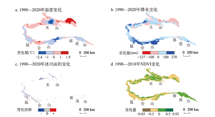
图6
1990—2020年西北内陆河流域自然因素变化
Fig. 6
Natural factors change in the inland river basins of Northwest China during 1990-2020
根据径流分割的结果,祁连山区多为降水主导型河流,以疏勒河、石羊河为典型代表,降水对径流的贡献率占绝大多数,融水补给较小,1990年以来的气象数据也表明该区域降水呈现增多的趋势[40]。并从图6c中可以发现祁连山地区冰川分布相对较少,且仅在黑河源头冰川面积有微弱增加,这与石羊河和疏勒河融水补给占比极小,而黑河融水补给为主有密切关联[41]。天山地区多为地下水补给型河流,地下水对径流的贡献最高,其次降水和融水也占一定的比重,这与天山地区较高的地表植被覆盖度有密切关系,高山植被对于降雨径流和融冰雪径流的拦蓄作用是区域地表水补给占比较大的重要原因[42]。位于西风上风向的天山西部和昆仑山西南部降水相较于其他区域较为丰沛[8,17,40],这导致该区域降水补给河川径流的比重较高[43](图6b)。而和田河位于提孜那甫河东侧,降水相对较少,并且上游有大面积的冰雪覆盖区,导致和田河的融水补给比重较大[44]。
5.2 径流风险评估
5.2.1 水质风险
根据生活饮用水卫生标准(GB5749-2022),生活饮用水pH值不小于6.5且不大于8.5,研究区内陆河流河水的pH值在7.52~8.10之间,基本达标,但博尔塔拉河(8.10)和和田河河水(8.07)的pH值有超出标准的风险,应引起注意(表5)。根据生活饮用水卫生标准(GB5749-2022),TDS值不能超过1000 mg/L,研究区内陆河河水TDS值在171.38~789.67 mg/L,基本达标,但和田河河水TDS值接近1000 mg/L,具有潜在的水质安全风险。另外快速变暖不仅会消融季节性冰川,还会导致西北内陆河流域山区冰川和永冻层消融加速,直接影响内陆河水体的水化学特征,带来水环境的风险[44]。前人研究表明,快速变暖导致亚洲水塔冰川消融加速,大量封存的污染物或重金属被释放,这对于内陆河水环境具有显著影响[31,33,36]。
表5 研究区不同内陆河流域河水水质特征
Tab. 5
| TDS(mg/L) | pH | SAR | Na% | RSC | |
|---|---|---|---|---|---|
| 博尔塔拉河 | 310.70 | 8.10 | 1.08 | 30.26 | -1.13 |
| 乌鲁木齐河 | 275.49 | 7.68 | 0.29 | 11.80 | -1.45 |
| 伊犁喀什河 | 239.38 | 8.00 | 0.15 | 8.32 | -0.45 |
| 开都河 | 426.60 | 8.00 | 0.43 | 13.47 | -1.36 |
| 阿克苏 | 323.25 | 7.86 | 1.48 | 35.02 | -2.07 |
| 疏勒河 | 526.87 | 7.52 | 1.04 | 23.70 | 0.35 |
| 石羊河 | 171.38 | 8.01 | 0.31 | 12.95 | -0.34 |
| 黑河 | 348.87 | 7.83 | 0.42 | 13.87 | -0.96 |
| 叶尔羌河 | 429.24 | 7.97 | 1.70 | 37.07 | -2.34 |
| 提孜那甫河 | 378.14 | 7.93 | 1.23 | 25.21 | -4.49 |
| 和田河 | 789.67 | 8.07 | 2.40 | 44.26 | -2.87 |
表6 河水灌溉适宜性指标标准
Tab. 6
| 参数 | 范围 | 等级 |
|---|---|---|
| SAR | ≤10 | 优秀 |
| 10~18 | 良好 | |
| 18~26 | 一般 | |
| >26 | 不适宜 | |
| Na% | ≤20 | 优秀 |
| 20~40 | 良好 | |
| 40~60 | 一般 | |
| 60~80 | 不确定 | |
| >80 | 不适宜 | |
| RSC | ≤1.25 | 安全 |
| 1.25~2.5 | 不确定 | |
| >2.5 | 不适宜 |
5.2.2 水量风险
5.2.3 气候变化风险
6 结论
本文选取祁连山、天山、昆仑山地区典型的内陆河流域,基于长期野外径流监测,以及降水、融水、河水、地下水样品的搜集与测试,得出以下结论:
(1)西北内陆河流域大部分河流年均径流量呈现上升趋势,石羊河呈现下降趋势,天山中部的乌鲁木齐河流量较为稳定。
(2)研究区水体多呈碱性,而天山地区的降水和冰川融水偏酸性;区域水体TDS值范围为64.70~794.50 mg/L,HCO3-和Ca2+和Na+为主导阴阳离子。河水TDS具有较为一致的季节变化趋势(夏秋低冬春高),而河水的各阳离子和阴离子季节差异显著。区域水体多为HCO3--Ca2+型,主要受控于岩石风化。
(3)除呼图壁河与石羊河外,区域河水的δ18O均呈现出夏秋低冬春高的季节变化特征,其中以阿克苏河水的季节变化最为显著。
(4)区域内陆河径流组分特征存在显著的空间异质性,地下水、降水和冰川/雪融水对区域内河径流的年平均贡献分别为42.6%、34.4%和23.0%。
(5)区域环境要素的波动给区域内河径流的模拟和估算带来了新的挑战。气温的变化会对阿克苏河、和田河和石羊河等河流的径流稳定带来风险,区域降水的波动会对提孜那甫河流域和疏勒河流域的径流稳定构成潜在的风险。除和田河外,西北内陆河流域水质风险相对较低。乌鲁木齐河流域的水量稳定性风险相对较低。
参考文献
Impact of climate change on water resources in the Tianshan Mountians, Central Asia
DOI:10.11821/dlxb201701002
[本文引用: 7]

Changes in hydrological processes and water resources under climate change in the Tianshan Mountains of Central Asia have been investigated based on data analysis and paper review. Under the context of global warming hiatus, temperature of the Tianshan Mountains in Central Asia has been in a state of high variability, which has accelerated the melting of glacier and snow. Warming has resulted in a series of changes in water resources. Snowfall fraction decreased from 11%-24% in 1960-1998 to 9%-21% in 2000-2014, 97.25% of the glaciers retreated in the last 50 years; and water storage decreased at a rate of -3.72 mm/a during 2003-2014. Warming has led to changes in mountainous hydrological processes and water resources. The runoff in the Tianshan Mountains has increased due to the accelerated glacier/snow melt, however, the runoff will decrease in the long term under continuous warming and current precipitation conditions.
气候变化对中亚天山山区水资源影响研究
DOI:10.11821/dlxb201701002
[本文引用: 7]
本文结合资料分析和文献阅读,对全球气候变化背景下的中亚天山山区水文、水资源变化进行了讨论分析。在全球升温滞缓背景下,中亚天山山区在过去的10余年,气温却一直处于高位态波动状态;气候变暖及持续高位态波动加剧了山区冰川和积雪等固态水体的消融,导致山区降雪率降低,天山山区降雪率从1960-1998年的11%~24%降低到2000年以来的9%~21%,有97.52%的冰川表现为退缩状态,水储量呈明显减少趋势,减小幅度约为-3.72 mm/a;气候变暖直接影响区域水循环和水系统的稳定性,引起径流补给方式和水资源数量的改变,加大了水资源时空分布的不确定性。天山山区在短时期内因冰雪融水增多,会出现径流量增加现象。但在未来气候持续变暖、降水条件维持不变的条件下,河川径流量将会出现减少趋势。
Analysis of the impact of global climate change on dryland areas
DOI:10.11867/j.issn.1001-8166.2022.006
[本文引用: 2]
Drylands cover about 41% of the Earth's land area, support more than 38% of the world's population, and are home to most of the world's developing and poor populations. Drylands are one of the most sensitive areas to the impacts and responses to global climate change, and it is essential to study the changes in their climate, hydrology and ecological environment. There have been many studies in this area in recent decades, but the conclusions are fragmented and there are many inconsistencies. Based on the analysis of domestic and international literature, this paper summarizes and composes the changes in climate, hydrology, area and type of drylands under climate change and the impacts of these changes on ecosystems. The main results of the combing are as follows. CO2 emissions from dryland are only about 30% of those from humid areas, but the warming rate is 20%~40% higher than that of humid areas. In the past half century, the dryland area has increased by about 2.61×10⁶ km2, and by the end of this century, the global dryland area will continue to expand by about 5.8×10⁶ km2, which will occupy more than half of the total land area. Under the background of global warming, the water resources system based on precipitation and snow melt recharge in drylands will be more fragile, and hydrological elements such as ice and snow and water resources composition will change, hydrological fluctuations will increase, and water resources uncertainty will intensify. Along with the expansion of dryland area and the increase of aridity, the shortage of water resources, shrinkage of water bodies, degradation of ecosystems and desertification in dryland areas will also intensify, and the future socio-economic development and ecological security of dryland areas will face more severe challenges. Some comprehensive conclusions condensed from these inductive combs are of reference significance for governmental decision making and for proposing credible and clear scientific understanding in the future.
全球气候变化对干旱区影响分析
DOI:10.11867/j.issn.1001-8166.2022.006
[本文引用: 2]
干旱区约占地球陆地面积的41%,养育了世界上超过38%的人口,是大多数发展中国家和贫困人口的聚集地,也是全球气候变化影响和响应最敏感的地区之一,对其气候、水文和生态环境变化开展研究是十分必要的。近几十年来相关研究不少,但结论比较零散,也有很多不一致的地方。基于对国内外文献的分析,归纳梳理了气候变化下干旱区的气候、水文、面积和类型的变化及其这些变化对生态系统的影响。梳理的主要结果如下:干旱区CO<sub>2</sub>排量约为湿润区的30%,但升温速率却比湿润区高20%~40%。在过去的半个多世纪,干旱区面积增加了约2.61×10<sup>6</sup> km<sup>2</sup>,预计21世纪末,全球干旱区面积将继续扩大约5.8×10<sup>6</sup> km<sup>2</sup>,占陆地总面积的一半以上。在全球变暖背景下,干旱区中以降水和冰雪融水补给为基础的水资源系统将会更为脆弱,冰、雪等水文要素及水资源构成发生改变,水文波动加大,水资源不确定性加剧。伴随干旱区面积扩大和干旱程度增加,干旱区水资源短缺、水体面积萎缩、生态系统退化、荒漠化程度也随之加剧,未来干旱区社会经济发展和生态安全保障将面临更严峻的挑战。这些归纳梳理所凝练出的一些综合性结论,对政府决策以及未来提出可信明确的科学认识具有一定的参考意义。
Impacts of climate change on the water cycle mechanism and water resources security in the arid region of Northwest China
气候变化对西北干旱区水循环影响机理与水资源安全研究
Hydrological and water cycle processes of inland river basins in the arid region of Northwest China
DOI:10.1007/s40333-019-0050-5
[本文引用: 10]
The increasing shortage in water resources is a key factor affecting sustainable socio-economic development in the arid region of Northwest China (ARNC). Water shortages also affect the stability of the region's oasis ecosystem. This paper summarizes the hydrological processes and water cycle of inland river basins in the ARNC, focusing on the following aspects: the spatial-temporal features of water resources (including air water vapor resources, runoff, and glacial meltwater) and their driving forces; the characteristics of streamflow composition in the inland river basins; the characteristics and main controlling factors of baseflow in the inland rivers; and anticipated future changes in hydrological processes and water resources. The results indicate that: (1) although the runoff in most inland rivers in the ARNC showed a significant increasing trend, both the glaciated area and glacial ice reserves have been reduced in the mountains; (2) snow melt and glacier melt are extremely important hydrological processes in the ARNC, especially in the Kunlun and Tianshan mountains; (3) baseflow in the inland rivers of the ARNC is the result of climate change and human activities, with the main driving factors being the reduction in forest area and the over-exploitation and utilization of groundwater in the river basins; and (4) the contradictions among water resources, ecology and economy will further increase in the future. The findings of this study might also help strengthen the ecological, economic and social sustainable development in the study region.
Research progress on the impact of climate change on water resources in the arid region of Northwest China
DOI:10.11821/dlxb201409005
[本文引用: 1]
The arid region of Northwest China is a special natural unit, which responds sensitively to the global climate change. Studies on the impact of climate change on water resources in the arid region of Northwest China have a significant effect on the adaptability of future climate change. Based on the latest research results, this paper analyzes the impacts of climate change on the formation and transformation of water resources and water cycle in the arid region of Northwest China. The results can be shown as follows: (1) The air temperature and precipitation in the arid region of Northwest China had a significant increasing trend in the past 50 years, however, the sharp increasing trend has retarded since the 21st century. (2) The temperature change in winter could be the most important factor for the unusually sharp rise in annual air temperature in this region. Moreover, the Siberian High and carbon dioxide emissions could be the most important reasons for the higher rate of the winter temperature rise. (3) Pan evaporation in the region exhibited an obvious decreasing trend until the early 1990s (1993), however, the downward trend reversed to go upward since 1993. The negative effects of warming and increasing evaporation on ecology have been highlighted in the arid region of Northwest China. (4) The glacier change has exerted great impact on water resources and its annual distribution in the arid region of Northwest China, and many rivers have passed the "Glacier inflexion". In the Tarim River Basin, the proportion of glacier melt water to runoff is high (e.g., as much as 50%) and it is supposed that the runoff may show a great fluctuation in the near future. Global warming not only increases the frequency and intensity of hydrological extremes, but also intensifies the fluctuation and uncertainty of inland rivers.
西北干旱区气候变化对水文水资源影响研究进展
DOI:10.11821/dlxb201409005
[本文引用: 1]
西北干旱区是对全球变化响应最敏感地区之一,研究分析全球变暖背景下的西北干旱区水资源问题,对应对和适应未来气候变化带来的影响具有重要意义。本文通过对西北干旱区气候变暖影响下的水资源形成、转化与水循环等关键问题最新研究成果的总结分析,得出如下结论:(1) 西北干旱区温度、降水在过去的50年出现过“突变型”升高,但进入21世纪,温度和降水均处于高位震荡,升高趋势减弱;(2) 西北干旱区冬季温度的大幅升高是拉动年均温度抬升的重要原因,而西伯利亚高压活动和二氧化碳排放是引起冬季升温的重要影响因素;(3) 西北干旱区蒸发潜力在1993年出现了一个明显的转折变化,由显著下降逆转为显著上升的趋势。气候变暖、蒸发水平增大对西北干旱区生态效应的负作用已经凸显;(4) 西北干旱区冰川变化对水资源量及年内分配产生了重要影响,部分河流已经出现冰川消融拐点。在塔里木河流域,冰川融水份额较大 (50%),可能在未来一段时期,河川径流还将处在高位状态波动。全球气候变暖在加大极端气候水文事件发生频率和强度的同时,加剧了西北干旱区内陆河流域的水文波动和水资源的不确定性。
Influence of climate change and human activity on water resources in arid region of Northwest China: An overview
气候变化及人类活动对西北干旱区水资源影响研究综述
Analysis of drought change and its impact in Central Asia
DOI:10.11867/j.issn.1001-8166.2021.124
[本文引用: 2]
Global warming has intensified the threat of drought in Central Asia, making problems such as water shortage, ecological degradation and transboundary river disputes more prominent. The research shows that in the past half century, the overall change trend of meteorological drought degree in Central Asia has not been significant. However, with the regional high temperature fluctuation, it has shown an obvious drying trend since 2000. About 65% of the regions show the intensification of drought degree, and the drought intensity will continue to increase under the SSPs scenarios in the future. We designed numerical experiments and found that drying trend responding to the dramatic increase in air temperature and slight decline in precipitation. From different drought sub categories, the area of extreme arid areas and arid areas in Central Asia shows an increasing trend at the rate of 0.02 × 10⁴ km2/a and 0.22 × 10⁴ km2/a, mainly concentrated in the northern margin of Tarim Basin in Xinjiang and in southern Kazakhstan. At the same time, about 84% and 81% of the soil moisture in the shallow layers (0~10 cm,10~40 cm) have exhibited decreasing trend, respectively. The increase of vegetation transpiration and soil water dissipation in plain desert areas has led to the decline and death of some shallow root desert plants with weak drought resistance, which depend on groundwater and soil water. The agro-ecological drought is intensified, and the hydrological drought is more complex. The conclusions will provide a scientific basis for water resources planning and management and ecological protection in Central Asia.
中亚地区干旱变化及其影响分析
DOI:10.11867/j.issn.1001-8166.2021.124
[本文引用: 2]
全球变暖加剧了中亚地区的干旱威胁,使得因干旱引发的水资源短缺、生态退化及跨境河流争端等问题更加突出。研究显示:过去半个多世纪,基于帕默尔干旱指数表征的中亚地区干旱程度整体变化趋势不显著,但伴随着区域的高温波动,中亚地区帕默尔干旱指数自2000年以来呈现明显下降趋势,约65%的区域表现为干旱化程度加剧,且在未来共享社会经济路径下中亚地区干旱强度持续增强。设计“去趋势”数字试验定量解析干旱指标对气候变化中各项因子的敏感性,发现气温对中亚干旱化趋势影响较大,降水变化加大了干旱的变率。从不同干旱亚类来看,中亚地区极端干旱区和干旱区面积以0.02×10<sup>4</sup>和0.22×10<sup>4</sup> km<sup>2</sup>/a的速率增加,主要集中在新疆塔里木盆地北缘和哈萨克斯坦南部等地区。同时,平原荒漠区的植被蒸腾和土壤水耗散量加大,浅层土壤含水量(0~10 和10~40 cm)分别约有84%和81%的区域表现为下降趋势,导致一些依靠地下水和土壤水维系生存的、抗旱性弱的浅根系荒漠植物衰亡,生态农业干旱加剧,且水文干旱呈更加复杂的态势,研究结论为中亚地区水资源规划管理和生态保护提供科学依据。
Chemical characteristics and their influencing factors of precipitation at the end of the Koxkar Glacier, Tianshan Mountains
天山科其喀尔冰川末端降水化学特征及控制因素
Response of the hydrological processes to climate change in the Muzati River basin with high glacierization,southern slope of the Tianshan Mountains
DOI:10.7522/j.issn.1000-0240.2020.0016
[本文引用: 2]
Muzati River is the most glacierized catchment on the southern slope of the Tianshan Mountains. As the high sensitivity of hydrological processes of the catchment to climate change, it is essential to quantify the impacts of climate change on hydrological processes for the scientific water resources planning, management and sustainable utilization. The VIC-CAS model was adopted as computing platform. The glacier inventory data and observed runoff were accounted for multi-objective calibration and validation to improve the “truth” of simulations. Then the runoff components, runoff variation characteristics and response mechanism of runoff to climate change were quantitatively analyzed using the simulations and observations. The following major conclusions are drawn: The runoff is concentrated in warm season (May to September), accounting for 77.9% to the annual runoff. The contribution of glacier runoff, snowmelt runoff and rainfall runoff to the total runoff was 66.6%, 26.4% and 7.0%, respectively. Over the past 40 years (1971 - 2010), the annual average air temperature and precipitation had shown a significant increasing trend. Due to increasing precipitation, the snowmelt runoff and rainfall runoff had shown increasing trends. But the annual runoff had shown a slight decreasing trend because of decreasing glacier runoff. Air temperature was projected to rise, while precipitation was projected to slightly decrease under RCP4.5 scenario. As air temperature rise, more precipitation will be in the form of rain. The rainfall runoff is predicted to obviously increase, while the snowfall and snowmelt runoff had been reached peak in 1990s, and significantly decline later. The glaciers are projected to retreat steadily, so the glacier runoff had reached a tipping point in 2010s. Annual runoff was projected to decrease significantly as a result of decreasing glacier runoff.
天山南坡高冰川覆盖率的木扎提河流域水文过程对气候变化的响应
DOI:10.7522/j.issn.1000-0240.2020.0016
[本文引用: 2]
木扎提河是天山南坡冰川面积覆盖率最大(48.2%)的河流, 流域径流过程对气候变化极为敏感, 为了合理管理和规划水资源, 确保水资源的可持续利用, 亟需定量评估气候变化对该流域水文过程的影响。以VIC-CAS分布式水文模型为计算平台, 利用实测的径流和两次冰川编目间的冰川面积变化数据开展了模型的多目标参数化校正和验证, 有效提高了模拟结果的“真实性”, 然后通过数值模拟结果结合观测数据定量解析了流域径流的组成、 变化特征及对气候变化的响应机理。结果表明: 木扎提河总径流集中在暖季(5 - 9月), 占全年总径流量的77.9%, 冰川径流、 融雪径流和降雨径流分别占总径流量的66.6%、 26.4%和7.0%。1971 - 2010年木扎提河流域气温和降水呈显著增加趋势, 由于降水的增加, 降雨和融雪径流均呈增加趋势, 但冰川径流呈现明显减少趋势, 导致总径流呈现下降趋势。在RCP4.5情景下, 未来该流域气温呈现明显升高趋势, 降水表现为微弱下降趋势; 气候变暖后, 更多降水以降雨形式发生, 未来降雨径流将明显增加, 降雪和融雪径流已于20世纪90年代达到峰值, 随后明显减少; 冰川面积将持续萎缩, 冰川径流于21世纪10年代达到拐点, 随后明显减少, 导致河道总径流量也将明显减少。
The stable isotope evolution in Shiyi glacier system during the ablation period in the north of Tibetan Plateau, China
Quantitative evaluation on the influence from cryosphere meltwater on runoff in an inland river basin of China
DOI:10.1016/j.gloplacha.2016.06.005 URL [本文引用: 3]
Stream component characteristics of the inland river basin of the Tarim basin under regional climate change
气候变化下的塔里木盆地西南部内陆河流域径流组分特征分析
Spatial and temporal characteristics of stable isotopes in the Tarim River Basin
DOI:10.1080/10256016.2016.1125350
PMID:26862902
[本文引用: 2]
By using 233 isotope samples, we investigated the spatial and temporal variations of δ(18)O and δ(2)H in precipitation and surface water, and the contribution of different water sources in the rivers within the Tarim River Basin (TRB), which receives snow/glacier meltwater, groundwater, and rainfall. Our study revealed a similar seasonal pattern of precipitation δ(18)O and δ(2)H at both the north and south edges of the basin, indicating the dominant effect of westerly air masses in the summer and the combined influence of westerly and polar air masses during the winter, although the southern part showed more complex precipitation processes in the summer. River water in the basin has relatively large temporal variations in both δ(18)O and δ(2)H showing a distinct seasonal pattern with lower isotope values in May than in September. Higher d-excess values throughout the year in the Aksu river and the Tizinafu river suggest that water may be intensively recycled in the mountains of the TRB. Based on isotopic hydrograph separation, we found that groundwater is the main water source that discharges the entire basin although individual rivers vary.
Isotopic time series partitioning of streamflow components under regional climate change in the Urumqi River, Northwest China
DOI:10.1080/02626667.2015.1031757 URL [本文引用: 4]
Comparative study of streamflow components in two inland rivers in the Tianshan Mountains, Northwest China
Provenances and controlling factors of solutes in surface runoff in the Tarim River Basin, Northwest China
Hydrochemical characteristics and ion sources of precipitation in the upper reaches of the Shiyang River, China
The Shiyang River Basin is located at the edge of the monsoon wind system of South and Southeast Asia. The hydrochemical characteristics of precipitation are influenced by both monsoon and arid regions. The regression analysis method, comparative analysis, neutralization factor (NF), enrichment factor (EF) and HYSPLIT4 were used to analyze the precipitation samples collected from the upper reaches of the Shiyang River from October 2016 to October 2017. In order to study the hydrochemical characteristics and ion sources of precipitation in this basin. The results, as discussed in this paper, show that the precipitation in the upper reaches of the Shiyang River is mildly alkaline all year round while the neutralization ability of Ca2+ and NH4+ in precipitation is strong. The ion concentration was higher in the dry season than that in the wet season, but the concentration of NH4+ was higher in summer. Furthermore, as the altitude increased, the electrical conductivity (EC) of the precipitation decreased gradually. Influenced by precipitation and rainy days, the wet deposition of nitrogen (N) and sulfur (S) was higher in the wet season than that during the dry season, and the wet deposition gradually increased with the elevation. In precipitation, the earth’s crust is a major source of Ca2+, K+ and Mg2+, the ocean is a major source of Cl−, the ocean and the earth’s crust are the sources of Na+, human activities are the main sources of SO42−, NO3− and NH4+, the amount of F− is very small, its sources are natural and human activities. Water vapor in precipitation mainly comes from westerly air mass circulation and monsoon circulation while the particles come mainly from the earth’s crust.
Hydrochemical characteristics and the relationship between surface and groundwater in a typical "Mountain-Oasis" ecosystem in Central Asia
Water environment monitoring is an important way to optimize the allocation and sustainable utilization of regional water resources and is beneficial for ensuring the security of regional water resources. In order to explore hydrochemical distributions in a mountain–oasis ecosystem in Central Asia, surface water and groundwater samples from the Kaidu River basin were collected over four seasons. pH values, major ions, total dissolved solids (TDS) and stable isotopes were determined during the period from 2016 to 2017. The results showed: (1) that most water bodies in the study areas were mildly alkaline and that hydrochemical distributions showed significant seasonal and spatial variation; (2) that δD and δ18O in surface water and groundwater showed enrichment in summer and autumn and poverty in spring and winter, with higher δ18O values appearing in the oasis area and lower δ18O values appearing in the mountain area; (3) that most of the water bodies in the study areas were of HCO3−Ca2+ type, with the hydrochemical types of groundwater presenting obvious spatial inconsistency relative to surface water; (4) that rock weathering was the main factor controlling hydrochemical composition in the study areas and that human activities had an influence on the groundwater environment in the oasis area; (5) and that surface water–groundwater interactions also displayed spatial inconsistency, especially in summer. The interaction between river water and groundwater was more obvious in the traditional oasis area, especially in spring and summer. The results will be important for regional water resource management and sustainable water utilization.
Influences of variability of stable isotopes and composition of moisture sources on precipitation at multiple timescales in the Alpine regions of Central Asia
An analysis of surface water-groundwater interactions based on isotopic data from the Kaidu River basin, south Tianshan Mountain
The unique climate conditions and water source composition in the Tianshan Mountain provide a good experimental site for verifying the relationships between water resources and climate change on a larger scale. With the help of water isotopes (D, 18O), a more reliable conceptual model of groundwater systems can be constructed on both local and regional scales, especially in areas that are susceptible to climate change and under pressure from intensive human activities. In this paper, we present δ18O, δD, d-excess, RWLs and altitude effects of river water and groundwater based on the data derived from our network of stable isotope sampling sites along the Kaidu River. Stable isotope mass balance was applied to study the interactions between groundwater and surface water and to quantify the recharge proportions between bodies of water in typical regions. The results showed that the Kaidu River is composed of precipitation, ice and snow melt, baseflow and groundwater. The percentage of groundwater increased with the distance between upstream (the runoff producing area) and the leading edge of the glacier. The two recharge areas are the spring overflow from the mountain area to the alluvial layer of the inclined plain and the leading edge of the alluvial plains to areas with fine soil. The groundwater recharge ratio is about 23% in high mountain areas but 46% or more in the middle and lower reaches. These results generated a more comprehensive understanding of the hydrological cycle of inland rivers in arid regions.
Analysis of water chemistry characteristics and hydraulic relationships of different water bodies in typical mountain-oasis systems in the Northwest inland area
典型西北山地—绿洲系统不同水体水化学特征及其水力关系分析
Risk assessment of groundwater hydrochemistry for irrigation suitability in Ordos Basin, China
DOI:10.1007/s11069-018-3451-4 [本文引用: 7]
Quantitative evaluation of the rainfall influence on streamflow in an inland mountainous river basin within Central Asia
DOI:10.1080/02626667.2017.1390314 URL [本文引用: 4]
Hydrogen and oxygen isotope composition and water quality evaluation for different water bodies in the Ebinur Lake watershed, northwestern China
Hydrochemical and stable isotopic spatiotemporal variation characteristics and their environmental significance in the Kashi River Mountain Area of Ili, Xinjiang, China
DOI:10.1007/s10653-021-00959-2 [本文引用: 1]
Characteristics of water stable isotopes (18O and 2H) in the Hutubi River Basin, Northwestern China
DOI:10.7522/j.issn.1000-694X.2015.00103
[本文引用: 1]
Water resources are the most critical factors to ecology and society in arid basins, such as the Hutubi River Basin. Isotope technique was convenient to trace this process and reveal the in uence from the environment. In this paper, we try to investigate the temporal and spatial characteristics in stable isotope (<sup>18</sup>O and D) of surface water and groundwater in the Hutubi River. Through the water stable isotope composition measurement, the characteristics of deuterium (<i>δ</i>D) and oxygen 18 (<i>δ</i><sup>18</sup>O) were analyzed. It is revealed that:(1) comparing the stream water line with the groundwater line and local meteorological water line of Urumqi, it is found that the contribution of precipitation to surface water in stream runoff is the main source, whereas the surface water is the main source of groundwater. Groundwater is mainly drainage of surface runoff in the river; (2) in the main stream of the Hutubi River, the spatial variability of river water showed a heavier-lighter-heavier' change along with the main stream for <i>δ</i><sup>18</sup>O, and temporal variability showed higher in summer and lower in winter; (3) the <i>δ</i><sup>18</sup>O value of Precipitation, surface water; groundwater and snowmelt were -12.42‰, -9.94‰, -10.23‰ and -19.42‰, respectively. the <i>δ</i><sup>2</sup>H values of Precipitation, surface water; groundwater and snowmelt were -86.25‰, -66.66‰, -69.82‰ and -150.79‰, respectively.
呼图壁河流域水体氢氧稳定同位素特征及转化关系
DOI:10.7522/j.issn.1000-694X.2015.00103
[本文引用: 1]
在气候变化和人类活动影响下,水资源短缺是干旱区面临的一个严峻问题.解决问题的关键是要深入了解干旱区独特的水循环机理,而分析不同水体中氢氧同位素特征及转化关系,是应用同位素示踪技术研究水循环机理的基础。以呼图壁河流域为研究区,分析了大气降水、河水、地下水和积雪融水氢氧同位素变化特征及不同水体的δD~δ<sup>18</sup>O关系,探讨了地表水对地下水的补给关系。结果表明:呼图壁河流域大气降水、河水、地下水和积雪融水中δD、δ<sup>18</sup>O的组成和季节变化差异较大,δD值分别为-86.25‰、-66.66‰、-69.82‰和-150.79‰,而δ<sup>18</sup>O值依次为-12.42‰、-9.94‰、-10.23‰和-19.42‰;河水受大气降水和冰雪融水的混合补给导致同位素的贫化,积雪融水主要受蒸发的影响导致同位素的富集,而河水和积雪融水对地下水有密切的水力联系,导致地下水同位素的贫化;呼图壁河上游地区河水对地下水的补给仅占到18.45%,而中下游区域的地下水补给占到90%以上。
Streamflow generation in semi‐arid, glacier‐covered, montane catchments in the upper Shule River, Qilian Mountains, northeastern Tibetan Plateau
The hydrogeochemical characteristics of the river water in the section from Bayi Glacier to Huargzangsi of the Heihe River, Qilian Mountains
祁连山黑河源区八一冰川—黄藏寺段河水水文地球化学特征
Hydrochemical characteristics and ion sources of river water in the upstream of the Shiyang River, China
Stable water isotope monitoring network of different water bodies in Shiyang River basin, a typical arid river in China
DOI:10.5194/essd-14-3773-2022
URL
[本文引用: 2]
. Ecosystems in arid areas are fragile and are easily disturbed by\nvarious natural and human factors. As natural tracers widely exist in\nnature, stable isotopes can be valuable for studying environmental change\nand the water cycle. From 2015 to 2020, we took the Shiyang River basin,\nwhich has the highest utilization rate of water resources and the most\nprominent contradiction of water use, as a typical demonstration basin to\nestablish and improve the isotope hydrology observation system. The data in\nthe observation system are classified by water type (precipitation, river\nwater, lake water, groundwater, soil water, and plant water). Six\nobservation systems with stable isotopes as the main observation elements have been built. These include river source region, oasis region, reservoir channel system region, oasis farmland region, ecological engineering construction region, and salinization process region; meteorological and hydrological data have also been collected. We will gradually improve the\nvarious observation systems, increase the data of observation sites, and\nupdate the data set yearly. We can use these data to research the\ncontinental river basin ecological hydrology, such as surface water\nevaporation loss, landscape river water cycle impact of the dam, dam water\nretention time, oasis farmland irrigation methods, and the atmosphere, such\nas the contribution of inland water circulation to inland river precipitation, climate transformation, below-cloud evaporation effect, and extreme climate events, which provides a scientific basis for water resources utilization and ecological environment restoration in the arid area. The data sets are available at https://doi.org/10.17632/vhm44t74sy.1 (Zhu, 2022).\n
The effects of runoff on hydrochemistry in the Qilian Mountains: A case study of Xiying River Basin
DOI:10.1007/s12665-018-7995-0 [本文引用: 2]
A synthesis of hydrochemistry with an integrated conceptual model for groundwater in the Hexi Corridor, northwestern China
DOI:10.1016/j.jseaes.2017.04.023 URL [本文引用: 1]
Hydrochemical compositions of natural waters in Ordos deserts and their influencing factors
DOI:10.11821/dlxb202109013
[本文引用: 6]
The analysis of hydrochemical compositions of natural waters and their influencing factors is helpful to understand the regional hydrogeological environment and hydrogeochemical development history. The Ordos Deserts, consisting mainly of the Mu Us Sandy Land and the Hobq Sand Sea, are located in the south of Hetao Plain, north to the Great Wall, surrounded by the Yellow River in the west, north and east, and adjacent to the Loess Plateau in the south. The Ordos Deserts make up the Ordos Plateau, with the same tectonic background, similar amount of precipitation and evaporation rates. There are a large number of lakes and rivers in these deserts. In this paper, based on the hydrochemical data of natural waters in the Ordos Deserts, the chemical compositions of natural waters and their influencing factors are analyzed, using various hydrochemical analysis methods. Results show that although Mu Us Sandy Land and Hobq Sand Sea have different landscapes, their natural waters of the same type have similar hydrochemical features, which should be related to their similar rates of evaporation. Deep groundwater in the Ordos Deserts is mainly Ca2+-HCO3- type and its chemical composition is mainly influenced by rock weathering. Due to strong evaporation, the hydrochemical nature of lakes in these regions is characterized with Na+-Cl- contents. As for shallow groundwater and river waters, their hydrochemical features and influencing factors show transitional characteristics between deep groundwater and lake water. The ion ratios show that the weathering of evaporites, carbonate and silicate rocks affects the hydrochemical composition of deep groundwater, shallow groundwater and river water to a varying degree. Although the groundwater and river water in the Ordos Deserts are suitable for irrigation, an excessive use of them will cause salinization, which should be given attention timely.
鄂尔多斯沙区天然水体水化学组成及其成因
DOI:10.11821/dlxb202109013
[本文引用: 6]
天然水体水化学组成及其成因分析既有助于重塑和预测区域水文地质环境及水文地球化学发展历史,也是水资源评价的基础。本文基于鄂尔多斯沙区天然水体水化学数据和前人在该地区的研究成果,利用多种水化学分析方法,对该地区天然水体的水化学组成及其成因进行分析。结果表明:鄂尔多斯沙区毛乌素沙地和库布齐沙漠虽然具有不同的沙漠景观,但其相同类型的天然水体具有相似的水化学性质和成因,该现象的出现可能和两者具有相似的蒸发量有关。鄂尔多斯沙区受蒸发影响较小的深层地下水水化学类型以Ca<sup>2+</sup>-HCO<sub>3</sub><sup>-</sup>型为主,其水化学组成主要受控于岩石风化;湖水蒸发较强烈,水化学类型为Na<sup>+</sup>-Cl<sup>-</sup>型,其水化学组成主要受控于蒸发—结晶过程的影响;浅层地下水和河水的水化学类型及其成因均处于两者之间,具有过渡特征。离子比例关系显示,蒸发岩风化、碳酸盐岩风化和硅酸盐岩风化在不同程度上影响着深层地下水、浅层地下水和河水的水化学组成。鄂尔多斯沙区地下水和河水虽然能满足灌溉水要求,但由于蒸发强烈,长期使用可能会引起盐碱化。本研究结果可为区域水资源可持续开发利用提供科学依据。
Variability of precipitation-stable isotopes and moisture sources of two typical landforms in the eastern Loess Plateau, China
Contribution of cryosphere to runoff in the transition zone between the Tibetan Plateau and arid region based on environmental isotopes
DOI:10.5194/hess-27-97-2023
URL
[本文引用: 3]
. As the transition zone between the Tibetan Plateau and arid region, the Qilian Mountains are important ecological barriers and source regions of inland rivers in northwest China. In recent decades, drastic changes in the cryosphere have had a considerable impact on the formation process of water resources in the Qilian Mountains. In this study, 2164 environmental isotope samples were used to quantify the runoff components of 11 major rivers in the Qilian Mountains and investigate the influence of cryosphere changes on mountain runoff. The results show that the mountain runoff primarily originates in the cryosphere belt, which contributes approximately 82 %, 71 %, and 80 % to the Hexi inland water system, the upper stream of the Yellow River system, and the Qinghai inland river system, respectively. The maximum contribution ratio of glacier and snow meltwater to runoff occurred in May. The contribution of supra-permafrost water to runoff gradually increased from May and reached approximately 40 % in some rivers in October. Cryosphere degradation in the Qilian Mountains after the 1990s has caused a rapid increase in runoff, changes in the peak runoff time, and an increase in winter runoff. These changes in the hydrological processes bring opportunities and challenges to managing inland river water resources, and various adaptive measures to seek advantages and avoid disadvantages have been proposed. The findings from the environmental isotope analysis provide insights into understanding water resources and realizing the nexus of life, agriculture, industry, and ecological water use.\n
Securing water quality of the Asian Water Tower
Substantial glacier mass loss in the Tien Shan over the past 50 years
DOI:10.1038/NGEO2513
[本文引用: 1]
Farinotti, Daniel; Duethmann, Doris; Vorogushyn, Sergiy; Guentner, Andreas GFZ German Res Ctr Geosci, D-14473 Potsdam, Germany. Farinotti, Daniel Swiss Fed Inst Forest Snow & Landscape Res WSL, CH-8903 Birmensdorf, Switzerland. Longuevergne, Laurent Univ Rennes, CNRS, UMR Geosci 6118, Natl Ctr Sci Res, FR-35042 Rennes, France. Moholdt, Geir Norwegian Polar Res Inst, Fram Ctr, NO-9296 Tromso, Norway. Moelg, Thomas Friedrich Alexander Univ Erlangen Nurnberg FAU, Inst Geog, Climate Syst Res Grp, D-91058 Erlangen, Germany. Bolch, Tobias Univ Zurich, Dept Geog, CH-8057 Zurich, Switzerland. Bolch, Tobias Tech Univ Dresden, Inst Cartog, D-01062 Dresden, Germany.
Water resources in inland regions of central Asia: Evidence from stable isotope tracing
DOI:10.1016/j.jhydrol.2019.01.003 URL [本文引用: 1]
Non-monotonic changes in Asian Water Towers' streamflow at increasing warming levels
Previous projections show consistent increases in river flows of Asian Water Towers under future climate change. Here we find non-monotonic changes in river flows for seven major rivers originating from the Tibetan Plateau at the warming levels of 1.5 °C, 2.0 °C, and 3.0 °C based on an observation-constrained hydrological model. The annual mean streamflow for seven rivers at 1.5 °C warming level decreases by 0.1-3.2% relative to the present-day climate condition, and increases by 1.5-12% at 3.0 °C warming level. The shifting river flows for the Yellow, Yangtze, Brahmaputra, and Ganges are mostly influenced by projected increases in rainfall, but those for the Mekong, Salween, and Indus are dictated by the relative changes in rainfall, snowmelt and glacier melt. Reduced river flows in a moderately warmed climate threaten water security in riparian countries, while elevated flood risks are expected with further temperature increases over the Tibetan Plateau.© 2023. The Author(s).
Stable isotope composition of precipitation in the south and north slopes of Wushaoling Mountain, northwestern China
DOI:10.1016/j.atmosres.2016.07.023 URL [本文引用: 2]
Chemical and strontium isotopic characteristics of the rivers around the Badain Jaran Desert, northwest China: Implication of river solute origin and chemical weathering
Spatial variations and controls on the hydrochemistry of surface waters across the Ili-Balkhash Basin, arid Central Asia
The glacier and snow variations and their impact on water resources in mountain regions: A case study in Tianshan Mountains of Central Asia
DOI:10.11821/dlxb201807010
[本文引用: 2]
Strongly impacted by climate change, glacier and snow, as major parts of solid reservoirs in mountains, can regulate the local water sources. This study uses glacier and snow datasets to analyze the variations of glaciers, snow, water storage, and runoff in the Tianshan Mountains, and selects three typical river basins (Aksu River, Kaidu River, and Urumqi River) to interpret the impact of glacier and snow changes on regional water resources in this region. Results indicate that: (1) the functional relationship between glaciers retreat and glaciers area is f(x) = -0.53×x-0.15 (R2 = 0.42, RMSE = 0.086), and small glacier retreat is more sensitive under climate change. Meanwhile, glacier retreat rate at the low-middle elevation bands is faster than that of the high elevation band; (2) the decreasing rate of regional average total water storage (TWS) is -0.7±1.53 cm/a in the study area during 2003-2015. The maximum of TWS deficit region was mainly observed in the central part of the mountains, which is closely related with accelerated glacier retreats; (3) during the past half century, the increased melting of glacier and snow melt led to a runoff increase in the three typical river basins, especially in the Aksu river basin (0.4×10⁸ m3/a). The area decreasing, thinning, and rising equilibrium line altitude (ELV) of glaciers are the major factor contributing to the decreasing trend of runoff in the three river basins since the mid-1990s. Therefore, results revealed that the mechanism of influence of solid water reserves reduction in mountains on regional water resources under climate change, and also provided references for water resources management in the mountainous river basin.
中亚天山山区冰雪变化及其对区域水资源的影响
DOI:10.11821/dlxb201807010
[本文引用: 2]
冰川和积雪是构成山区固体水库的主体,对区域水资源稳定性具有调节功能,但深受气候变化的影响。以中亚天山为研究区域,基于长时间序列的观测数据,分别从冰川、积雪、水储量、径流等方面进行分析,并选取阿克苏河、开都河及乌鲁木齐河3个典型流域,研究天山山区冰雪变化对流域水资源的影响。结果表明:① 冰川退缩速率与面积的函数关系为f(x) = -0.53×x<sup>-0.15</sup> (R<sup>2 </sup>= 0.42,RMSE = 0.086),说明小型冰川对气候变化的响应更为敏感。同时,中低海拔区域的冰川退缩速率大于高海拔区域;② 2003-2015年天山山区水储量的递减速率为-0.7±1.53 cm/a,天山中部区域的递减速率最大,这一结果与该区域冰川急剧退缩相吻合;③ 近半个多世纪以来,冰雪融水径流增加是这3个典型流域径流量增加的主要原因,其中阿克苏河增幅最大(达0.4×10<sup>8</sup> m<sup>3</sup>/a)。但自20世纪90年代中期以来,3个流域的径流量都呈减少趋势,与流域内冰川面积减少、厚度变薄及平衡线海拔升高的关系密切。研究结果揭示了气候变化驱动下的山区固态水体储量变化对流域水资源的影响机制,以期为流域水资源管理提供有价值的决策参考。
The rapidly shrinking cryopshere in the past decade:an interpretation of cryospheric changes from IPCC WGI Sixth Assessment Report
最近十多年来冰冻圈加速萎缩: IPCC第六次评估报告之冰冻圈变化解读
Hydrochemical characterization and irrigation suitability analysis of shallow groundwater in Hetao irrigation district, Inner Mongolia
内蒙古河套灌区浅层地下水化学特征和灌溉适宜性分析
Groundwater quality and associated human health risk in a typical basin of the eastern Chinese Loess Plateau
Groundwater is an important source for drinking, agricultural, and industrial purposes in the Linfen basin of the Eastern Chinese Loess Plateau (ECLP). To ensure the safety of drinking water, this study was carried out to assess the quality using the water quality index (WQI) and potential health risks of groundwater using the human health risk assessment model (HHRA). The WQI approach showed that 90% of the samples were suitable for drinking, and Pb, TH, F−, SO42−, and TDS were the most significant parameters affecting groundwater quality. The non-carcinogenic health risk results indicated that 20% and 80% of the samples surpassed the permissible limit for adult females and children. Additionally, all groundwater samples could present a carcinogenic health risk to males, females, and children. The pollution from F−, Pb, and Cr6+ was the most serious for non-carcinogenic health risk. Cd contributed more than Cr6+ and As to carcinogenic health risks. Residents living in the central of the study area faced higher health risks than humans in other areas. The research results can provide a decision-making basis for the scientific management of the regional groundwater environment and the protection of drinking water safety and public health.
Precipitation isotope characteristics and water vapor sources in summer in eastern Loess Plateau
DOI:10.11821/dlxb202207012
[本文引用: 2]
The composition of hydrogen and oxygen stable isotopes of atmospheric precipitation can indicate the climatic and environmental changes of precipitation process. It is of great significance to analyze and understand the changes of stable isotopes of atmospheric precipitation and examine the hydrological cycle process under current and past climatic conditions. Based on the determination of δ2H and δ18O in 152 precipitation samples collected from 8 stations in the eastern Loess Plateau in the summer of 2019 (April-October), the spatial and temporal distribution characteristics of δ2H and δ18O and their relationship with meteorological parameters and sub-cloud evaporation were systematically analyzed. The HYSPLIT model was used to analyze the source and migration path of water vapor. The results show that: (1) δ2H and δ18O of summer precipitation in the study area have obvious seasonal variation, which gradually enriched from May to July and gradually depleted from August to September; the precipitation δ2H and δ18O also showed significant spatial differences, with a gradual increase from southeast to northwest. (2) The results of regional atmospheric precipitation line show that the overall precipitation in this area is significantly affected by the sub-cloud evaporation, but the precipitation process in the basin area (Zhaocheng, Yangquan, and Changzhi) is significantly affected by the local circulation. (3) δ18O in the precipitation of this region did not show significant indigenous temperature effect and precipitation effect. The temperature effect only existed in the Jiexiu station of the Fenhe river basin valley, while the precipitation effect existed at the Jiexiu and Linfen stations. (4) The sub-cloud evaporation has a significant influence on the Yangquan station in the middle of the rocky areas of Taihang Mountains, the Datong station in the north and the Linfen station in the Fenhe river basin valley. The hydrogen and oxygen stable isotopes of the cloud bottom and surface precipitation are significantly different. (5) The results of water vapor source analysis show that the main sources of summer precipitation in the region are near the ground and the Bohai Sea in the southeast direction, and the water vapor content of the western path in the long distance is relatively small. The results of this study are of great significance to improve the understanding of regional water cycle and the rational allocation of water resources.
黄土高原东部夏半年降水稳定同位素特征及水汽来源分析
DOI:10.11821/dlxb202207012
[本文引用: 2]
大气降水氢氧稳定同位素的组成可以指示降水过程的气候环境变化,分析大气降水稳定同位素的变化,对于研究气候条件下的水文循环过程具有重要意义。本文基于2019年夏半年(4—10月)黄土高原东部8个站点采集的152个降水样本的δ<sup>2</sup>H和δ<sup>18</sup>O的测定,系统分析δ<sup>2</sup>H和δ<sup>18</sup>O的时空分布特征及与气象参数、云下蒸发的关系,并利用HYSPLIT模型分析了水汽来源及运移路径。结果表明:① 研究区夏半年降水δ<sup>2</sup>H<sup>1</sup>和δ<sup>18</sup>O存在显著的季节变化,其中5—7月逐渐富集、8—9月逐渐贫化;研究区降水δ<sup>2</sup>H和δ<sup>18</sup>O亦表现出显著的空间差异,整体上呈现由东南向西北逐渐增加的趋势。② 区域大气降水线的结果表明,该区整体上降水受云下蒸发作用较为显著,但位于盆地地区(赵城、阳泉、长治)降水过程受局地内循环影响较明显。③ 该区域降水中δ<sup>18</sup>O并未表现出显著温度效应和降水量效应,仅汾河谷地的介休站存在温度效应而介休、临汾站存在降雨量效应。④ 云下蒸发过程对太行山土石山区中部的阳泉站、北部的大同站以及汾河谷地的临汾站影响较为显著,其云底与地表降水的氢氧稳定同位素差异较显著。⑤ 水汽来源分析的结果显示,该区域夏季降水的主要来源为近地及东南方向下的渤海等地,远距离下的西方路径水汽含量占比较小。本文的结果对于增进区域水循环的认识及水资源的合理优化配置具有重要意义。
Impacts of the increasing vegetation coverage on groundwater recharge in an alpine and arid endorheic river watershed
高寒内陆河流域植被覆盖增加对地下水补给的影响
Modelling the impact of vegetation change on hydrological processes in Bayin River basin, Northwest China
Vegetation change in arid areas may lead to the redistribution of regional water resources, which can intensify the competition between ecosystems and humans for water resources. This study aimed to accurately model the impact of vegetation change on hydrological processes in an arid endorheic river watershed undergoing revegetation, namely, the middle and lower reaches of the Bayin River basin, China. A LU-SWAT-MODFLOW model was developed by integrating dynamic hydrological response units with a coupled SWAT-MODFLOW model, which can reflect actual land cover changes in the basin. The LU-SWAT-MODFLOW model outperformed the original SWAT-MODFLOW model in simulating the impact of human activity as well as the leaf area index, evapotranspiration, and groundwater table depth. After regional revegetation, evapotranspiration and groundwater recharge in different sub-basins increased significantly. In addition, the direction and amount of surface-water–groundwater exchange changed considerably in areas where revegetation involved converting low-coverage grassland and bare land to forestland.
