

1 引言
在联合国提出的17项可持续发展目标(Sustainable Development Goals, SDGs)中,“可持续城市与社区”被列为第11项(SDG11),旨在“建设包容、安全、有抵御灾害能力和可持续的城市和人类住区”,是实现所有SDGs的核心[7]。SDG11涵盖了城市社会、经济、环境、安全等诸多方面,能够较为完整地刻画一个城市的可持续发展水平[8]。除了SDG11外,SDG1涉及的贫困、SDG4的教育、SDG6的城市用水、SDG8的经济增长以及SDG9的基础设施建设等,均与城市发展息息相关,这些目标中的一些指标也可服务于城市SDGs监测。SDG11及相关目标为全球城市的发展指明了方向,也为城市可持续发展评估提供了具体指标,是在统一框架下开展不同城市的评价与比较研究的重要依据[9]。以SDG11为核心的城市SDGs监测评估是衡量城市可持续发展水平的标尺,也是谋划城市未来发展的重要科学基础,已经成为可持续发展领域的研究重点[6,8,10 -11]。
针对以SDG11为核心的城市SDGs监测评估,国内外组织和学者开展了一系列卓有成效的研究工作,目前主要聚焦在SDGs概念解析、监测数据提取、指标优化及计算、单尺度评估及小范围实验等方面。然而,由于城市是一个复杂巨系统,涵盖社会、经济、环境等多个高度交织的领域,涉及要素众多,同时SDGs监测又面临着指标体系的科学理解、多源多尺度数据的融合处理、跨学科的综合分析等诸多技术难题,目前仍缺乏规范统一的城市SDGs监测体系和科学高效的监测评估方法[12]。在回顾已有综述研究中发现,目前学界对城市SDGs监测领域研究的全面认识尚未完全形成,有必要对城市SDGs监测,特别是基于地理信息的城市SDGs空间型监测方法与其进展进行全面梳理。
基于上述认识,本文首先从空间型监测的概念、指标体系、监测数据获取、监测思路与方法等方面对城市SDGs监测评估的研究内容进行系统梳理,进而揭示城市SDGs空间型监测的发展历程和最新研究进展。在此基础上,提出目前城市SDGs空间型监测研究面临的问题与挑战,并对城市SDGs空间型监测评估的未来研究重点方向进行归纳与总结,以满足日益增长的实践需求。
2 城市SDGs空间型监测及进展
2.1 基于地理信息的空间型监测概念
传统城市可持续发展监测评估大多基于统计调查数据,受数据实时性差、空间分辨率低及获取困难的影响,无法快速、准确地评估城市可持续发展水平[9];同时,由于这些统计调查数据多以行政区为单元收集,仅仅反映了某一时段单元的平均或者整体状况,因而基于它们的监测评估不能有效地反映和揭示SDGs践行情况的地理空间格局、区域差异以及时空效应[13]。而具有地理空间信息的遥感及网路大数据及其分析技术的出现为实现大样本量、更高时间和空间分辨率的可持续发展评价提供了新选择[8]。基于统计和地理空间信息相结合的空间型监测评估,由于使用了具有较高时空分辨率、客观性较强且易于获取的地球大数据,不但可以提高评估的时效性和准确性,还为人们描述可持续发展状况的地理分布特征与地域差异,揭示SDGs实施的地理空间条件及时空效应,讲述可持续发展的空间故事,提供了可能[13⇓⇓-16]。
为此,联合国在2015年首次正式将地理空间信息纳入全球性可持续发展目标的监测评估,国际上有关机构也组织开展空间型监测(Geospatial-enabled SDGs Monitoring,GI4SDGs)研究[14,17]。例如,联合国跨机构SDGs指标专家委员会(IAEG-SDGs)专门设立了地理信息工作组,国际地球观测组织(GEO)成立了“对地观测支撑SDGs”研究计划,中国成立了“可持续发展大数据国际研究中心”,开展相关的科学研究。目前国内外学术界尚没有明确给出SDGs空间型监测的定义,通过梳理分析相关研究,本文认为SDGs空间型监测就是综合利用各类地理空间数据,在数据空间化的基础上实现基于栅格单元的指标计算,以反映评估单元内部可持续发展状况的地理分布与地域差异。与传统的基于统计数据的监测评估相比较,空间型监测具备两个突出特征:一是数据的空间化。指标计算采用具有地理空间信息的数据,或者是空间化的统计数据。二是结果的空间化。评估结果是随空间位置变化而变化的量值,具有空间分布特征,可以反映评估单元内部可持续发展状况的地理分布差异。
2.2 监测指标体系
2.2.1 目标及指标间相互关系研究
已有研究表明,联合国SDGs之间存在普遍联系,它们之间关系复杂,既有权衡关系,又有协同关系[21⇓⇓-24]。有学者将可持续发展目标间关系分为部分目标间以及整体目标间关系,以追踪并理解目标间存在的协同和权衡关系,为弱化目标间冲突、探索最优发展方案提供了基础[25]。也有学者利用可持续发展目标相互作用图对目标间关系进行评级,并用于强调政策实施的优先考虑事项[22]。而对于具体的指标,有学者通过最大信息系数(Maximal Information Coefficient, MIC)、Spearman算法对2000—2017年联合国各成员国的SDGs指标相关系数以及方向进行计算,以确定不同指标间关联性大小[26]。在城市可持续发展目标和指标关系研究方面,Abastante等评估了2030年可持续发展议程和SDG11指标的关系,指出SDG11指标存在的问题[27]。Simon等通过对5个城市的研究,分析了SDG11子目标和对应指标之间的关系,提出指标选择的10个原则,并建议在能够对城市关键方面完成监测的基础上,减少相关子目标和指标的数量[28]。研究者的一个普遍认识是,可持续发展评估指标数量繁多,关系复杂,缺乏明确的核心关键指标,不利于监测评估的实施[29]。
2.2.2 指标的适应性及其优化研究
全球SDGs指标框架虽然形成和确立了一系列国际通用的指标概念,但其难以适应不同国家和地区应用的需求,需要根据不同情景做出相应的调整[11,18]。同时,尽管SDGs指标机构间专家小组[30]对每个指标给出了详细的元数据信息,包括指标概念与定义、计算方法和数据源等,但仍有一些指标定义不清晰,对相关目标及子目标的整体性描述不充分,甚至相互重叠,需要进行优化[27,31]。为此,大量研究重新梳理了目标、子目标和指标之间的关系,并结合不同城市的发展水平和实际需求,对指标的适应性进行了分析,提出了相应的优化和调整方案。例如,Koch等结合德国的具体情况,认为SDG11中只有一部分指标可以直接使用,其余大多数指标需要做相应的调整,以适应不同的需求[18];高峻等结合中国城市发展现状,指出SDG11指标在评估城市可持续发展水平上不够完善,需要结合其他SDGs目标对其进行有效补充[19];Brussel等讨论了指标SDG11.2描述不足的缺点,在此基础上提出两个替代指标,新指标能较好地评估城市不同区域的社会经济和空间不公平性,以帮助识别城市交通薄弱区域[32];Diaz-Sarachaga等在对SDG11目标和指标之间关系解析的基础上,结合墨西哥城的实际情况,提出一个新的指标框架[33]。总之,尽管SDG11对城市可持续发展的认识已较为全面,但由于指标本身描述不充分及相互重叠的问题,加之不同城市的资源环境本底、社会经济发展特征、所处发展阶段具有较大差距,所面临的发展问题也存在显著差异,因此,在具体评估中有必要结合具体情况对SDG11指标进行优化与完善[8,32,34]。
2.3 服务于监测的地理空间数据获取
2.3.1 关键地理空间数据获取
城市SDGs监测评估中的一些指标,必须在地理空间数据的支持下完成其计算,这些地理空间数据就成为指标计算的关键。例如,各类城市功能区数据是SDG11指标计算必须的一类关键地理空间数据,其中包括指标11.1.1中的居住区、11.7.1中涉及的开放公共空间等。对于这类数据,一种有效的获取手段是利用高分辨率遥感影像进行自动分类提取[38]。然而当前遥感影像分类方法更多地用于城市中的单一要素(例如水体、绿地、建筑物等)的提取。例如,2019年欧洲航天局发布的300 m分辨率的全球陆地覆盖数据GlobCover 2009、欧盟发布的全球人类居住层数据Global Human Settlement layer、中国研制的全球首套30 m分辨率全球地表覆盖数据集GlobeLand 30、德国宇航中心提供的城市建成区数据Global Urban Footprint以及清华大学宫鹏教授研究组发布的全球30 m分辨率不透水面数据等[39]。这些数据主要反映城市地表物理特性或城市建成区范围,为研究城市可持续发展提供了强有力的支撑,但其中大多数数据仍不能直接应用于城市可持续发展监测评估。这是因为城市SDGs中涉及的许多指标围绕城市功能区设置,而城市功能区是由多种要素组成的复杂体。对于复杂城市功能区,目前比较先进的方法是采用机器学习等人工智能技术,结合众源地理信息进行城市功能区的自动分类提取,虽然取得了较大进展,但其自动化程度及精度仍然不够理想[40⇓-42]。
2.3.2 多源数据融合及利用
不同来源的数据各有优缺点,将这些不同来源的数据配准后,采用一定的算法将其优点和互补性结合起来,形成新的、更优的数据集,提高时空分辨率或改善精度,以满足SDGs监测的需求,是那些缺乏高质量数据的国家或地区的一种可能选择,也是当前的一个研究热点[43-44]。例如,一些学者在多源遥感数据权重设置的基础上,通过分析多源遥感数据间的一致性,建立融合决策规则,对多源遥感数据源进行融合,生成需要的数据[45-46]。此外,城市社会经济层面,离不开对社会经济以及人类活动、人类行为的了解和刻画,即社会感知方式,近年来Geo-Wiki、OpenStreetMap、空间社交媒体数据及手机信令数据等众源地理数据的大量出现,为构建SDGs时空数据集提供了新的信息来源[47⇓-49]。但是,如何利用这类数据进行社会感知,协助SDGs评估监测,还需要进一步的研究数据特征、处理方法和相关信息提取等[9]。总之,针对SDGs指标计算和评估监测的需求,发展适宜的空间数据融合及多源数据利用的方法,生成需要的时空数据集,也是今后的一项研究任务。
2.3.3 统计数据空间化
一些SDGs指标计算要用到社会经济统计数据,但这类数据绝大多数是以行政区划或人口普查区为单元收集的,仅能表示统计对象在空间区域上的平均状况,难以反映其空间上的真实分布或分散程度[50]。为了便于与地理空间信息进行融合分析,实现SDGs量化评估结果的空间化,需要采用地理空间分解,即针对特定社会经济现象的特点,构建起适宜的模型,反演出统计数据在地理空间中的分布状态,生成连续变化的数据面[51]。同样地,基于自然单元(如流域、土壤类型单元等)或者采样点获得的一些环境类采样数据,往往难以有效覆盖全部空间,也需要推算出无测站点区域的要素值,实现空间化[52]。通常,人们针对具体研究对象的特点,构建适宜的模型,反演出统计数据或者采样数据在地理空间中的分布状态,以实现数据的空间化[51,53]。例如,Aquilino等利用哨兵影像和人口普查数据,构建其与人口迁移数据的多元回归关系,将人口普查单元的统计数据展布到地理格网上,服务于SDG11.1.1及SDG11.3.1的计算[54]。目前国际上已研制了一些数据产品,如WorldPop、GPWv4等,可以在一定程度上满足大区域监测的需求,但对城市而言,如何精确地将这些社会经济统计数据展布在街道乃至居住小区等具体评价单元上,仍需要研究。
2.4 监测思路与方法
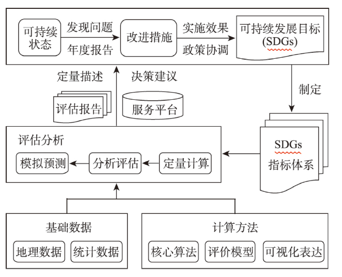
图1
2.4.1 基本变量监测
尽管目前以SDG11为核心的城市SDGs监测评估总体思路比较明确,但在具体实践过程中,由于所面临的城市具有复杂巨系统特征,涉及的监测指标众多,需要获取和处理海量的地理空间数据,并非每一个国家或地区均可承受,因此,如何创新监测思路也是当前研究的一个重点[31]。国际气侯、海洋、生物多样性领域面临类似的问题,它们采用的是以基本变量为基础,去构建监测体系并实现复杂系统观测的做法。基本变量是指标计算的依据,是观测数据和指标之间联系和转换的桥梁,其不仅能反映复杂系统的本质,而且具有不可替代性[55]。全球气候观测系统(GCOS)曾研究凝练了一组气候基本变量(Essential Climate Variables, ECVs)[56],海洋观测框架确定了一组海洋基本变量(Essential Ocean Variables, EOVs)[57],国际“生物多样性和生态系统服务政府间科学—政策平台(IBPES)”提出了生物多样性的基本监测变量(Essential Biodiversity Variables, EBVs)[58],基于这些基本变量,国际气候、海洋、生物多样性领域实现了各自领域的高效监测。借鉴这一成功经验,国际科联“未来地球”科学委员会专家不久前提出建议,要求根据SDGs监测的主要需求,凝练和定义一组能反映SDGs主要特征和变化的基本变量作为持续性监测的对象,以构建规范统一、科学高效的SDGs监测体系[29,59]。总之,基本变量思路为解决复杂系统的高效监测提供了一个新途径,但其仅限于概念讨论,尚未进行试验研究。
2.4.2 空间型指标计算方法
表1 可利用地理信息计算的SDG11指标举例
Tab. 1
| 编号 | SDGs指标内容 |
|---|---|
| 11.1.1 | 居住在贫民窟、非正式住区或住房不足的城市人口比例 |
| 11.2.1 | 可便利使用公共交通的人口比例,按年龄、性别和残疾人分列 |
| 11.3.1 | 土地使用率与人口增长率之比 |
| 11.6.2 | 城市细颗粒物(如PM2.5、PM10)年平均水平(按人口权重计算) |
| 11.7.1 | 城市建设区中供所有人使用的开放公共空间的比例,按性别、年龄和残疾人分列 |
对于这些具有地理空间维度的SDGs指标(空间型指标),需要设计专门的算法或模型,提取与之相关的密度、关系、可达性、覆盖度等空间变量,实现指标的计算或提取[37,61 -62]。例如,Melchiorri等利用Global Human Settlement Layer(GHSL)数据计算了土地消耗率及人口增长率,进而求得11.3.1[63];Aquilino等利用哨兵影像数据,结合人口普查数据计算了人口迁移率,服务于SDG11.1.1和SDG11.3.1的计算[54]。目前,仍有一些指标缺乏科学的计算方法,有些指标的计算方法具有较大的局限性,需要改进和完善[64-65]。例如,指标11.3.1的现有计算公式仅从经济的角度,评价土地消耗率与人口增长率的关系,没有考虑其对社会和环境的影响,需要进行扩展[64]。
2.4.3 评估分析及知识服务
自联合国发布SDGs全球指标框架SGIF后,许多机构和学者对基于SGIF的SDGs监测评估和应用实践展开研究。例如,联合国研究机构(Sustainable Development Solutions Network, SDSN)进行了149个国家和地区的SDGs基准线评估[66],联合国西亚经济社会委员会完成了1990—2010年22个阿拉伯国家SDGs进展与趋势评估[67]等。但其并未使用地理空间信息,因而不能有效地反映和揭示SDGs践行情况的地理空间格局、区域差异以及时空效应等[37]。2018年陈军等对面向2030年可持续发展议程的县域(浙江省德清县)SDGs进行综合评估研究,完成经济、社会和环境3个目标群的综合分析[68]。该评估将统计和地理信息有机结合,是首次面向县域SDGs的综合性评估研究。此外,有学者也结合地理信息和对地观测数据对SDG11进行评估研究[64,69]。例如,Simone等结合城市代谢和生命周期评估,发展了一些新的多维指标框架,评估了城市的可持续性[70];Ira等对尼日利亚城市可持续发展SDG11进行了评估,并分析了该国在满足SDG11中面临的机遇及挑战[69]。这些研究均是以行政区为单元的单尺度评估,以一个数值反映评估单元的可持续发展状态,缺乏多尺度视角,不能精确反映单元内部的差异性[71]。此外,SDGs空间分布格局、时空变化等知识,不仅可为可持续发展空间决策提供底图,而且对可持续发展状况的状态诊断、情景预测和模拟具有重要作用。然而,当前SDGs时空信息智能化知识服务的理论方法和技术仍不成熟,对“数据—信息—知识”转化机理认知不清、时空信息服务计算理论和动态服务机理研究不透、监测结果的知识挖掘不够、知识服务受限,难以满足SDGs时空知识服务的需求。
3 空间型监测的挑战与展望
基于现阶段不同国家部门对城市SDGs监测评估的迫切需求和SDGs监测评估自身的发展趋势,城市SDGs空间型监测评估理论和技术方法均需要有所突破,具体可能有5个方面将成为城市SDGs监测今后发展的重点方向(图2)。首先,需要改进传统的监测思路,建立科学高效的监测评估方法和规范统一的监测指标体系;其次,需要构建服务于监测评估的数据库,以及监测评估知识服务平台,推动监测评估结果服务于政府决策部门及大众;此外,在理论及技术层面,应加强多源遥感等地球大数据和地理学等相关学科支撑SDGs监测评估的应用研究,为城市SDGs监测评估提供数据、理论及技术支撑。
图2
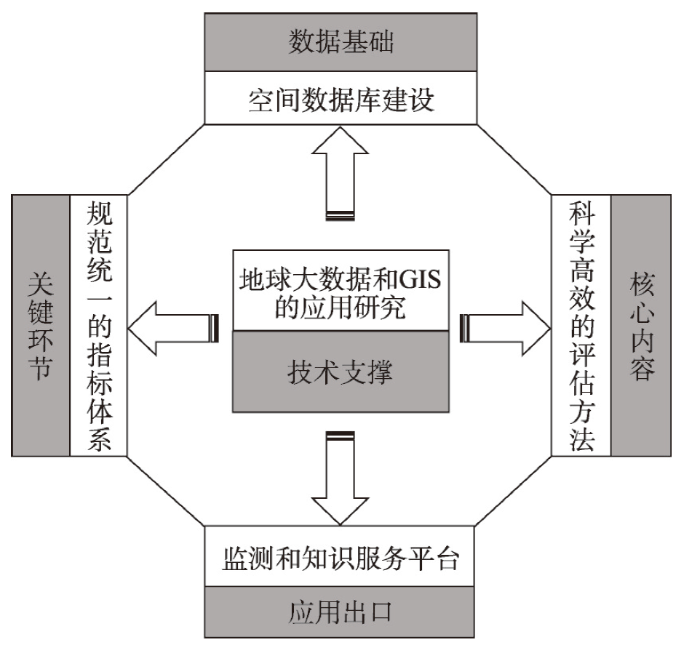
图2
城市SDGs空间型监测未来重点研究方向
Fig. 2
Key research directions of geospatial-enabled SDGs monitoring in future
3.1 建立科学高效的监测评估方法
首先需要完善传统的基于指标的监测方法。传统的监测评估方法没有顾及城市的空间异质性和多尺度特性,从单尺度对其评估,难以反映单元内部发展的不平衡性和空间差异性。为此,需要突破传统城市可持续性评价以市、县等行政区划为空间单元,以年为最小时间单元的评价模式,探索不同时间空间尺度上的监测评价方法,包括不同尺度观测数据、基本变量及指标之间的多级关联关系、不同尺度评价结果的转换关系及尺度效应等。其次,需要研究发展SDGs监测评估的新方法和新模型。例如,采用先进的人工智能、机器学习、数据挖掘等方法,构建网络大数据、遥感数据、地面监测和社会统计数据与评价指标间的代用关系,实现SDGs动态、快速、准确地监测和评估。最后,需要进一步研究SDGs指标预测模型,为未来SDGs实现评估提供治理仿真指导。
3.2 建立规范统一的监测指标体系
规范统一的监测指标体系是衡量城市可持续发展水平的关键。尽管联合国提出的SDG11指标框架形成和确立了一系列国际通用的指标概念定义、统计标准和计算方法,但是一些指标的概念和计算方法在中国并不适用,需要进一步改进和完善。一是当前的监测指标体系涉及的指标数量较多,且关系错综复杂,加重了本已严重的数据获取负担,给监测评估带来了更大的困难[28];二是监测指标的覆盖面与适用性存在不足,需要根据不同需求对指标体系进行改进和完善[19,32,72]。为此,需要深入分析研究监测目标和指标内涵以其它们之间的关系,确定一些核心关键指标,以及用于指标计算的基本变量。同时,积极开展指标的本土化研究,积极探索研究全球框架下的SDGs指标如何与中国具体国情相结合,建立一套既能比较评估,又具有可操作性的规范统一的指标体系,服务于城市SDGs监测评估。
3.3 构建数据生产共享服务平台
数据缺失是SDGs在具体实施过程中面临的最艰巨的挑战,而数据统计体系不完善、不一致,以及数据标准缺失是造成数据缺乏和质量不高的主要原因[73]。为此,在城市空间型SDGs监测中,首先需要利用快速发展的大数据技术(包括对地观测技术、通信技术、计算技术和网络技术等)解决城市SDGs监测中城市功能区数据提取、长时序地理空间数据生成以及统计数据的空间化等问题;其次,在研究解决数据的一致性问题(包括时间、空间、属性及语义等的一致性)的基础上,建立数据共享的观念、机制、标准及相关基础设施,打破部门之间的数据孤岛,加强部门之间的数据共享与紧密合作,实现真正的数据共享;最后,基于对象存储系统和云服务模式,构建可持续发展大数据共享服务平台,整合基础地理、遥感、地面监测、社会统计等多种数据及可持续发展信息产品,实现SDG11数据的收集、处理和产品生产,形成SDG11评估的系列数据产品,服务于可持续发展监测评估。
3.4 构建监测评估知识服务平台
目前SDGs监测评估中关注的重点是监测指标体系的建立与监测数据获取,而对SDGs实践和行动有实际指导意义的知识服务缺乏足够的重视。SDGs监测的基本目的是摸清SDGs执行情况以及是否达到预定的发展目标,这意味着要真正发挥SDGs监测的作用,必须从监测结果中提取出目标型、系统型和变革型等有用知识,告诉决策者和公众“怎么样、做什么、怎样做”,即帮助他们了解本区域离2030SDGs还有多远,哪些地域(或空间区位)存在问题或差距,应该采取什么样的空间型行动方案[74]。为此,需要研究发展SDGs知识服务、知识化表达和知识的检索服务等技术,构建监测评估的知识服务平台,努力从传统的监测评估结果展示走向诊断型、预报型和方案型知识服务。
3.5 加强地球大数据和相关学科支撑SDGs监测的应用研究
首先,地球大数据中包含大量的地理空间信息,这些空间信息的引入,为有效反映和揭示SDGs践行情况的地理空间格局、区域差异以及时空效应提供了可能。地球大数据不仅直接应用于指标计算,还可辅助统计数据的空间分解、支撑评估结果的空间化展示等。总之,当前的监测评估中,研究者们越来越认识到地球大数据的重要性,并将其广泛地应用于SDGs的监测评估中[75]。但是目前对地学大数据的作用仍缺乏系统深入地研究,尤其在城市SDGs监测评估中,各个目标评估和指标计算具体涉及哪些地球大数据?它们在具体的监测评估中起什么作用?哪些地球大数据最能反映城市发展状态与水平?如何利用这些地球大数据进行城市SDGs监测评估?目前这些研究才刚刚起步,还不够深入。其次,地理科学综合性、交叉性和区域性的研究优势使其成为可持续发展的基础性学科[16,76],地理学及其相关学科为人们描述可持续发展状况的地理分布特征与地域差异,揭示SDGs实施的地理空间条件及时空效应,讲述可持续发展的空间故事,提供了理论和技术可能[13-14]。为此,需要加强地球大数据以及相关学科支撑城市SDGs监测评估的研究。一方面,发展地球大数据方法、多源数据融合方法、深度学习方法在数据挖掘、模型构建等方面的潜力,提高监测评估结果的可靠性和先进性;另一方面,加强地理学、城市科学、生态环境学等学科支撑可持续发展目标监测的应用研究,为城市SDGs监测评估提供理论和技术支撑。
4 总结
对可持续发展目标进行科学监测评估,是世界各国落实联合国2030可持续发展议程的一项重要举措,也是国际社会面临的一项科技挑战。其中,基于统计和地理空间信息相结合的城市SDGs空间型监测评估能够较为准确地反映城市内部可持续发展状况的地理分布特征与地域差异,已经成为可持续发展领域的研究重点。本文将该研究领域划分成监测指标体系、服务于监测的地理空间数据获取、监测思路与方法等3个方面,系统地分析了国内外的最新研究进展和现状。认为当前的研究仍停留在概念解析及数据提取、指标优化及计算、单尺度评估及小范围实验等方面,难以满足日益增长的空间型监测实践需求。目前,城市SDGs空间型监测面临指标体系亟待完善、数据获取亟需加强、监测思路和方法亟待创新等方面的挑战。为此,将城市SDGs空间型监测评估未来发展趋向归纳为5点,即建立科学高效的监测评估方法、建立规范统一的监测指标体系、构建数据生产共享及监测评估知识服务平台、加强地球大数据和相关学科支撑城市SDGs监测的应用研究等。
参考文献
Sustainability and resilience for transformation in the urban century
DOI:10.1038/s41893-019-0250-1
[本文引用: 1]

We have entered the urban century and addressing a broad suite of sustainability challenges in urban areas is increasingly key for our chances to transform the entire planet towards sustainability. For example, cities are responsible for 70% of global greenhouse gas emissions and, at the same time, 90% of urban areas are situated on coastlines, making the majority of the world's population increasingly vulnerable to climate change. While urbanization accelerates, meeting the challenges will require unprecedented transformative solutions for sustainability with a careful consideration of resilience in their implementation. However, global and local policy processes often use vague or narrow definitions of the concepts of 'urban sustainability' and 'urban resilience', leading to deep confusion, particularly in instances when the two are used interchangeably. Confusion and vagueness slow down needed transformation processes, since resilience can be undesirable and many sustainability goals contrast, or even challenge efforts to improve resilience. Here, we propose a new framework that resolves current contradictions and tensions; a framework that we believe will significantly help urban policy and implementation processes in addressing new challenges and contributing to global sustainability in the urban century.
Theoretical analysis of interactive coupled effects between urbanization and eco-environment in mega-urban agglomerations
DOI:10.11821/dlxb201604001
[本文引用: 1]
Mega- urban agglomerations in China play a vital role in both national economic development strategies and national new-type urbanization, and undertake important historical responsibility with the world economic center transfer to China. However, they suffer a series of increasingly serious eco- environmental problems in the process of development. Thus,studies on the interactive coupled effects between urbanization and eco-environment in megaurban agglomerations are the frontier areas and high priority tasks in the earth system science for the future ten years. This paper analyses the basic theory frame of the interactive coupled effects between urbanization and eco- environment in mega- urban agglomerations systematically. In theoretical aspect, based on the nonlinear relationship and coupling characteristics of the natural and human elements in mega- urban agglomerations system, we could estimate the interactive coercing intensity, nearcoupling and telecoupling mechanism ofthe inside and outside mega-urban agglomerations system after scientific identification of the key elements, and then form the basic interactive coupling theory. Moreover, we could build a spatio- temporal coupling dynamic model, which is integrated with multi- elements, multiscales,multi-scenarios, multi-modules and multi-agents. The model will be used to develop the intelligent decision support system for urban agglomeration sustainable development. In methodology aspect, the mega- urban agglomeration is regarded as an open complex giantsystem. We should establish the standardized shared database for exploring the interactive coupled effects between urbanization and eco- environment. Then using new technology for analyzing big data and the integration methods incorporating of multi- elements, multi- scales,multi- targets, multi- agents, multi- scenarios and multi- modules, we can build a methodology framework to analyze the complex interaction coupling between urbanization and ecoenvironment. The technical route is to analyze spatiotemporal evolution characteristics, identifythe key elements, interpret coupling relationship, reveal the mechanism of coercing effect, find the general rules, filtrate the control variables, solve the critical thresholds, conduct regulation experiments, simulate different scenarios, propose an optimized schemes, and achieve national goals. Furthermore, we could put forward the overall optimization scheme. In general, this research could provide theoretical guidance and method support for the transformation and sustainable development in mega-urban agglomerations.
特大城市群地区城镇化与生态环境交互耦合效应解析的理论框架及技术路径
DOI:10.11821/dlxb201604001
[本文引用: 1]
特大城市群地区是国家经济发展的战略核心区和国家新型城镇化的主体区,担当着世界经济重心转移承载地的历史重任,但在发展过程中面临着日益严重的资源与生态环境的胁迫压力。开展特大城市群地区城镇化与生态环境交互耦合效应的研究,是未来10 年地球系统科学研究的前沿领域和高优先研究主题。本文系统解析了特大城市群地区城镇化与生态环境交互耦合效应的基本理论框架。首先从理论上分析了特大城市群系统各自然要素和人文要素交互作用的非线性耦合关系及耦合特征,科学辨识近远程主控要素作用下城市群系统内外部各要素相互作用的胁迫强度、近远程耦合机理与规律,总结特大城市群地区城镇化与生态环境交互耦合圈理论,进一步构建多要素—多尺度—多情景—多模块—多智能体集成的时空耦合动力学模型,研发特大城市群地区可持续发展优化智能调控决策支持系统;其次从方法上将特大城市群地区视为一个开放的复杂巨系统,在建立同一标准化共享数据库的基础上,采用多要素—多目标—多模型—多情景环境下的城镇化与生态环境交互耦合集成技术方法、大数据支持下的城镇化与生态环境交互耦合技术方法,构建多尺度—多技术—多智能体集成的城镇化与生态环境交互耦合技术框架,按照分析时空演变特征—寻求主控要素—辨识耦合关系—揭示胁迫机制—发现耦合规律—筛选调控变量—求解临界阈值—进行调控试验—完成情景模拟—提出优化方案—完成情景模拟—提出优化方案—实现国家目标这样一条技术路径,提出解决问题的整体优化方案。本文旨在为特大城市群地区由问题集中区转为可持续发展区提供理论指导和方法支撑。
Winning the SDG battle in cities: How an integrated information ecosystem can contribute to the achievement of the 2030 Sustainable Development Goals
DOI:10.1111/isj.v27.4 URL [本文引用: 1]
Roles of sustainable urbanization in promoting the implementation of UN Sustainable Development Goals in China
持续城镇化对中国推进实施联合国可持续发展目标的作用
Achieving the SDGs: Evaluating indicators to be used to benchmark and monitor progress towards creating healthy and sustainable cities
DOI:S0168-8510(18)30441-X
PMID:30935701
[本文引用: 2]
In 2016, the World Health Organization declared that 'Health is one of the most effective markers of any city's successful sustainable development' (World Health Organisation, 2016). With estimates that around 6.7 billion people will live in cities by 2050, 21 century city planning decisions will play a critical role in achieving the United Nations (UN) Sustainable Development Goals (SDGs). They will determine the city structure and access to health-enhancing (or health-damaging) urban environments, and ultimately lifestyle choices that impact both individual and planetary health. Benchmarking, monitoring and evaluating city planning policies and interventions is therefore critical to optimise urban outcomes. In 2017, the UN adopted a global SDG indicator framework, calling for complementary national and regional indicators to be collected by member countries. UN Habitat has also developed an indicator action framework specifically for cities. This paper examined the extent to which the UN indicators will help cities evaluate their efforts to deliver sustainability and health outcomes. It identified inconsistencies between the two UN indicator frameworks. Many of the SDG indicators assess outcomes, rather than the comprehensive and integrated 'upstream' policies and interventions required to deliver outcomes on-the-ground. Conversely, the UN Habitat framework incorporates intervention indicators, but excludes health outcome indicators. A more comprehensive approach to benchmarking, monitoring and evaluating policies designed to achieve healthy and sustainable cities and assessing spatial inequities is proposed.Copyright © 2019 Elsevier B.V. All rights reserved.
Building a global urban science
DOI:10.1038/s41893-017-0013-9 [本文引用: 1]
Progresson sustainable city assessment index system for SDGs
面向SDGs的城市可持续发展评价指标体系进展研究
Urban sustainability evaluation based on remote sensing and network data support: Progress and prospect
DOI:10.11867/j.issn.1001-8166.2018.10.1075.
[本文引用: 3]
The sustainable development of the city is the key to the realization of the global sustainable development goals. Urban sustainability evaluation is a measure to the sustainable development of cities, and basis of sustainable urban development. The current evaluation method is based on statistical data which is low spatial resolution, long period and high cost. In recent years, remote sensing data, network data and the multivariate data have been used for the evaluation for the sustainable development of cities, and there have been many related research cases, which provides a new idea and method to carry out the high resolution evaluation of urban sustainable development rapidly, accurately and cheaply. This article reviewed the remote sensing data and network data in the progress of the application in the evaluation to the sustainable development of cities, and discussed the advantages of remote sensing and network big data in the objectivity, accuracy, and timeliness of evaluation compared with traditional data. Based on the sustainable urban development indicators of the United Nations Sustainable Development Goals (SDG), a basic framework for the evaluation of sustainable development of cities with high temporal and spatial resolution of big data such as remote sensing data and network big data was proposed. The introduction of remote sensing and network big data will change the inherent paradigm of sustainability assessment, make high-resolution real-time evaluation possible, further innovate analytical techniques, improve data accuracy, and make clear the alternative relationship with traditional data being the focus and the only way to realize the replacement of traditional data by remote sensing and network big data.
遥感与网络数据支撑的城市可持续性评价: 进展与前瞻
DOI:10.11867/j.issn.1001-8166.2018.10.1075.
[本文引用: 3]
城市可持续发展是关系全球可持续发展目标实现的重中之重,城市可持续性评价是度量城市可持续发展水平的标尺,是实现城市可持续发展的基础。当前的评价方法多以统计数据为基础,评价时空分辨率低、周期长、花费高。近年来,遥感数据、网络大数据等多元数据陆续被用于城市可持续性评价,相关研究案例大量涌现,这为快速、准确、廉价地开展高分辨率城市可持续性评价提供了新的思路与方法。回顾了遥感数据、网络大数据在城市可持续性评价中的应用进展,探讨了遥感和网络大数据相较于传统数据在评价客观性、准确性、时效性方面的优势。在此基础上,以联合国可持续发展目标(SDG)中城市可持续发展指标为导向,提出了基于遥感数据、网络大数据等地球大数据开展高时空分辨率城市可持续性评价的基本框架。遥感与网络大数据的引入将改变可持续性评价的固有范式,使高分辨率实时评价成为可能,进一步创新分析技术、提升数据精度、明确与传统数据的替代关系是遥感和网络大数据实现对传统数据替代的工作重点。
Urban sustainability strategies guided by the SDGs: A tale of four cities
The United Nations (UN) 2030 Sustainable Development Agenda, signed in 2015 and backed-up with its seventeen Sustainable Development Goals (SDGs), mentions cities as key players for evolving actively towards more sustainability. This underpins that living in the cities of the urban age is increasingly becoming the focus of sustainability discussions, which is particularly reflected in SDG 11 “Making cities and human settlements inclusive, safe, resilient and sustainable”. As urban sustainability strategies are playing a key role for the development of cities, this article sheds light on four cities’ sustainability strategies. The case studies highlight shortcomings, in terms of integrated visions, clear targets, and indicators in existing urban (sustainability) strategies. The article discusses these issues in light of an analytical framework, and stresses challenges and opportunities that SDG implementation involves.
Big earth data supports sustainable cities and communities: Progress and challenges
地球大数据助力“可持续城市和社区”目标实现: 进展与挑战
Assessing progress towards sustainable development over space and time
DOI:10.1038/s41586-019-1846-3 [本文引用: 1]
Quantitative evaluation of sustainable development goals (SDGS) based on geographic information
基于地理信息的可持续发展目标(SDGs)量化评估
Sustainable development and geospatial information: A strategic framework for integrating a global policy agenda into national geospatial capabilities
DOI:10.1080/10095020.2017.1325594 URL [本文引用: 3]
A project on big earth data science engineering
地球大数据科学工程
UN Sustainable Development Goals and historical mission of geography
联合国可持续发展目标与地理科学的历史任务
ISPRS-International Archives of the Photogrammetry, Remote Sensing and Spatial Information Sciences
How to contextualize SDG11? Looking at indicators for sustainable urban development in Germany
Agenda 2030 pursues a universal approach and identifies countries in the Global South and in the Global North that are in need of transformation toward sustainability. Therefore, countries of the Global North such as Germany have signed the commitment to implement the Sustainable Development Goals (SDGs). However, the SDGs need to be “translated” to the specific national context. Existing sustainability indicators and monitoring and reporting systems need to be adjusted as well. Our paper evaluates how three different initiatives translated SDG 11 (“Make cities and human settlements inclusive, safe, resilient, and sustainable”) to the German context, given the specific role of cities in contributing to sustainable development. These initiatives included the official ‘National Sustainable Development Strategy’ of the German Government, a scientific initiative led by the ‘German Institute for Urban Affairs’, and a project carried out by the ‘Open Knowledge Foundation’, a non-governmental organization (NGO). This article aims to analyze how global goals addressing urban developments are contextualized on a national level. Our findings demonstrate that only a few of the original targets and indicators for SDG 11 are used in the German context; thus, major adjustments have been made according to the main sustainability challenges identified for Germany. Furthermore, our results show that the current contextualization of SDG 11 and sustainable urban development in Germany are still ongoing, and more changes and commitments need to be made.
Urban sustainable development evaluation with big earth data: Data, indicators, and methods
地球大数据支持下的城市可持续发展评估: 指标、数据与方法
World sustainable development: From action to science:Sustainability science and the annual report for world sustainable development 2015
可持续发展从行动走向科学: 《2015世界可持续发展年度报告》
Map the interactions between Sustainable Development Goals
Reflections on China's promotion and implementation of Sustainable Development Goals
关于中国推进实施可持续发展目标的若干思考
Progress in research on the relationship between Sustainable Development Goals
可持续发展目标关系研究进展
The updated research progress of evaluation and implementation of Sustainable Development Goals: From the perspective of goal relationship
联合国可持续发展目标的评估与落实研究最新进展: 目标关系的视角
A dataset of correlation coefficients of UN member states' SDGs indicator pairs during 2000-2017
2000—2017年联合国各成员国的SDGs指标对相关性系数数据集
Pursuing the SDG11 targets: The role of the sustainability protocols
Developing and testing the Urban Sustainable Development Goal's targets and indicators: A five-city study
DOI:10.1177/0956247815619865
URL
[本文引用: 2]
The campaign for the inclusion of a specifically urban goal within the United Nations’ Sustainable Development Goals (SDGs) was challenging. Numerous divergent interests were involved, while urban areas worldwide are also extremely heterogeneous. It was essential to minimize the number of targets and indicators while still capturing critical urban dimensions relevant to human development. It was also essential to test the targets and indicators. This paper reports the findings of a unique comparative pilot project involving co-production between researchers and local authority officials in five diverse secondary and intermediate cities: Bangalore (Bengaluru), India; Cape Town, South Africa; Gothenburg, Sweden; Greater Manchester, United Kingdom; and Kisumu, Kenya. Each city faced problems in providing all the data required, and each also proposed various changes to maximize the local relevance of particular targets and indicators. This reality check provided invaluable inputs to the process of finalizing the urban SDG prior to the formal announcement of the entire SDG set by the UN Secretary-General in late September 2015.
Integration: The key to implementing the Sustainable Development Goals
DOI:10.1007/s11625-016-0383-3
PMID:30147763
[本文引用: 2]
On 25 September, 2015, world leaders met at the United Nations in New York, where they adopted the Sustainable Development Goals. These 17 goals and 169 targets set out an agenda for sustainable development for all nations that embraces economic growth, social inclusion, and environmental protection. Now, the agenda moves from agreeing the goals to implementing and ultimately achieving them. Across the goals, 42 targets focus on means of implementation, and the final goal, Goal 17, is entirely devoted to means of implementation. However, these implementation targets are largely silent about interlinkages and interdependencies among goals. This leaves open the possibility of perverse outcomes and unrealised synergies. We demonstrate that there must be greater attention on interlinkages in three areas: across (e.g., finance, agriculture, energy, and transport), across societal (local authorities, government agencies, private sector, and civil society), and between and among low, medium and high income. Drawing on a global sustainability science and practice perspective, we provide seven recommendations to improve these interlinkages at both global and national levels, in relation to the UN's categories of means of implementation: finance, technology, capacity building, trade, policy coherence, partnerships, and, finally, data, monitoring and accountability.
When less is more: Innovations for tracking progress toward global targets
Access or accessibility? A critique of the urban transport SDG indicator
Progress towards the UN Sustainable Development Goals (SDGs) is being evaluated through the use of indicators. Despite the importance of these indicators, the academic community has done little in terms of a critical reflection on their choice, relevance, framing and operationalization. This holds for many SDG domains, also for the urban sector domain of target 11. To partially address this void, we aim to critically review the UN methodology for the urban access indicator, SDG indicator 11.2. In discussing its conceptual framing against the background of paradigm shifts in transportation planning, we argue that this indicator has a number of shortcomings. The most important one is that it is supply oriented and measures access to transportation infrastructure, rather than accessibility to activity locations. As an alternative, we develop two accessibility indicators that show substantial variation in accessibility across geographical areas. We implement all indicators for the city of Bogotá in Colombia, using a geo-information based approach. Our results show that SDG indicator 11.2 fails to represent the transport reality well. Its supply oriented focus neglects transport demand, oversimplifies the transport system and hides existing inequalities. Moreover, it does not provide useful evidence for targeting new interventions. The proposed accessibility indicators provide a more diverse, complete and realistic picture of the performance of the transport system. These indicators also capture the large spatial and socio-economic inequalities and can help to target improvements in urban transportation.
Development and application of a new resilient, sustainable, safe and inclusive community rating system (RESSICOM)
DOI:10.1016/j.jclepro.2018.10.061
[本文引用: 1]
The rising concern about sustainable development led most states worldwide to adopt the 2030 Agenda for Sustainable Development to achieve 17 new goals before the end of 2030. Due to the prominent role of urbanization, the Sustainable Development Goal (SDG) #11 was introduced to make cities and human settlements more resilient, sustainable, safe and inclusive. The frameworks built so far to assess sustainable urban development primarily focus on sustainability, disregarding inclusiveness, safety and resilience. Under the joint consideration of these four facets, this research devised a new tool to evaluate communities and cities by selecting 61 indicators from an extensive literature review, which were weighted subsequently to ensure the balance among the four sustainability dimensions, namely society, economy, environment and governance. Data extracted from international organizations and the targets of the SDGs were used to score the indicators of the system. Mexico City, as one of the most overcrowded cities in the planet, was selected as a case study to apply the proposed tool. The research determined that the minimum thresholds set for the safety, sustainability and inclusiveness domains were not reached. In contrast, the city performed over the resilience limit. Consequently, RESSICOM was revealed as a helpful framework to identify shortcomings in cities related to the achievement of SDG #11. (C) 2018 Elsevier Ltd.
The urban sustainable development goal: Indicators, complexity and the politics of measuring cities
DOI:10.1016/j.cities.2016.12.019 URL [本文引用: 1]
The role of comparative city policy data in assessing progress toward the urban SDG targets
Filling environmental data gaps for SDG 11: A survey of Japanese and Philippines cities with recommendations
Measuring regional progress towards SDGs by combining geospatial and statistical information
DOI:10.11947/j.AGCS.2019.20180563
[本文引用: 3]
The 17 Sustainable Development Goals (SDGs) defined by the Transform our World:2030 Agenda for Sustainable Develepment represents a new coherent way of embracing economic prosperity, social inclusion, and environmental protection as an "indivisible whole". In order to ensure the implementation of this global agenda, the United Nations had proposed a systematic follow-up and review through indicators-based tracking and reporting of the progress with statistical and geospatial information towards SDGs at national, regional and global levels. This has posed many technical and coordination challenges, such as selection of appropriate indicators for a given nation or sub-nation regions, availability and acquisition of reliable data sets, spatio-temporal analysis with a geographical perspective, interaction between SDGs and cross-sector coordination. Although the international society has devoted great attention to this hot topic, most of them remain on the conceptual design and preliminary testing. There are very few good practices for a comprehensive measurement and assessment of progress towards SDGs with integration of statistical and geospatial information at nation or sub-national level. This paper presents the methodology and results of a pioneer project which measured the progress towards SDGs at a county level in China by combining integration of statistical and geospatial information. The major conclusions are ① the comprehensive progress towards SDGs in an entire administrative region can best be measured and assessed by integrating geospatial and statistical information; ② the Deqing county has made significant economic and social advances while maintaining a good ecological environment over the past few years. The results were released at the first United Nations World Geospatial Information Congress as a good practice and a live example to stimulate discussions and further actions on better supporting SDGs with geospatial information.
顾及地理空间视角的区域SDGs综合评估方法与示范
DOI:10.11947/j.AGCS.2019.20180563
[本文引用: 3]
目前世界各国正积极落实联合国《2030年可持续发展议程》及其17项可持续发展目标(Sustainable Development Goals,英文缩写为SDGs),重要举措之一是利用统计和地理信息进行SDGs进展评估监测。就总体而言,国内外这方面研究尚处于概念设计、方法探讨和单指标、小范围试点阶段。究其原因,主要是涉及因素众多、技术过程复杂,既面临全球指标体系的科学理解、海量时空数据的融合处理、顾及地理视角的指标计算、基于事实的SDGs分析评估等诸多技术难题,还要实现跨学科的综合分析、多机构的沟通协调等。针对这一国际前沿课题,笔者研究提出了统计和地理信息相结合的综合评估方法,完成了浙江省德清县践行2030议程情况的定量综合评估。既为总结当地践行SDGs经验、发现存在问题、制定改进方案提供了重要科学依据,也为国内外其他区域开展SDGs定量评估监测提供了可借鉴的方法与范例。
Spatial heterogeneity in urban ecosystems: Reconceptualizing land cover and a framework for classification
DOI:10.1890/1540-9295(2007)5[80:SHIUER]2.0.CO;2 URL [本文引用: 1]
Annual maps of global artificial impervious area (GAIA) between 1985 and 2018
Semantic classification of urban buildings combining VHR image and GIS data: An improved random forest approach
DOI:10.1016/j.isprsjprs.2015.03.011 URL [本文引用: 1]
Heuristic sample learning for complex urban scenes: Application to urban functional-zone mapping with VHR images and POI data
DOI:10.1016/j.isprsjprs.2020.01.005 URL [本文引用: 1]
An SOE-based learning framework using multisource big data for identifying urban functional zones
DOI:10.1109/JSTARS.2021.3091848 URL [本文引用: 1]
Towards integrated social-ecological sustainability indicators: Exploring the contribution and gaps in existing global data
DOI:10.1016/j.ecolecon.2015.07.024 URL [本文引用: 1]
Progress in spatial data fusion: From classic approaches to extended methods
空间数据融合的研究进展: 从经典方法到扩展方法
A methodology to generate a synergetic land-cover map by fusion of different land-cover products
DOI:10.1016/j.jag.2012.04.011 URL [本文引用: 1]
Mapping priorities to focus cropland mapping activities: Fitness assessment of existing global, regional and national cropland maps
DOI:10.3390/rs70607959 URL [本文引用: 1]
Urban big data and Sustainable Development Goals: Challenges and opportunities
Big data and social indicators: Actual trends and new perspectives
DOI:10.1007/s11205-016-1495-y URL [本文引用: 1]
Incorporating multi-source big geo-data to sense spatial heterogeneity patterns in an urban space
集成多源地理大数据感知城市空间分异格局
Spatially-integrated social sciences and GIS: A personal perspective
DOI:10.11821/xb201108008
[本文引用: 1]
One of the most important advancements in recent social science research (including applied social sciences and public policy) has been the application of computational methods in studying the complex human or social systems. Geographic Information Systems (GIS) has played an important role in this movement because of its capability of integrating and analyzing various datasets, particularly spatial data. Social sciences with a spatial focus can be grouped as "spatially-integrated social sciences". Drawing from research projects supported by various federal grant agencies in the U.S., this paper uses examples to demonstrate the value of GIS in social sciences including economics (urban economics), history and linguistics, sociology (criminology) and public health.
社会科学和公共政策的空间化和GIS的应用
A proposed method for spatial data disaggregation and interpolation
DOI:10.1080/00330124.2016.1158116 URL [本文引用: 2]
Study on spatialization technology of terrestrial eco-information in China (Ⅰ): The approach of spatialization in meteorology/climate information
DOI:10.11849/zrzyxb.2004.04.017
[本文引用: 1]
The study brings forward the basic conception of spatial information system for Chinese terrestrial ecosystem.Based on reviews of recent spatialization technology research of meteorology and climate information at home and abroad,we appraised virtue of methods in existence and discussed the model of spatial distribution of meteorology and climate information.Meanwhile,we summarized our preliminary achievement and set forth prospective applications.The developments of ecological,resources and environmental sciences imperiously call for spatia-lization technology research and data product exploitation of Chinese terrestrial eco-information.However,establishing a favorable spatial database of terrestrial eco-information which provides fine spatial-temporal resolution fitting in with diverse disciplines requirements demands long-ter-m study and disciplinary cooperation;simultaneously,it needs a lot of social funds devotion.
中国陆地生态信息空间化技术研究(Ⅰ): 气象/气候信息的空间化技术途径
A review on the spatial disaggregation of socioeconomic statistical data
DOI:10.11821/dlxb202210015
[本文引用: 1]
Socioeconomic statistical data is usually aggregated in units of administrative regions. The socioeconomic statistical data can reflect the heterogeneity between statistical units, but it cannot reflect the heterogeneity within a statistical unit. The socioeconomic statistical data cannot meet the needs of socioeconomic departments concerned in arbitrary regions. The spatial disaggregation of socioeconomic statistical data is an effective way to solve this problem. This study summarizes the existing methods of spatial disaggregation of socioeconomic statistical data, the auxiliary data used in methods for obtaining spatial disaggregation of socioeconomic statistical data, and the main socioeconomic grid data products. This study also predicts future development trends of the spatial disaggregation of socioeconomic statistical data in three aspects: the constraints and improvement directions of methods, the exploration of new auxiliary data and the comprehensive utilization of multi-source auxiliary data, the development of high temporal and spatial resolution and high-precision grid data products. The research results can provide references for the selection and improvement of spatial disaggregation methods of socioeconomic statistical data, the selection and comprehensive utilization of auxiliary data, and the selection and improvement of socioeconomic grid data products.
社会经济统计数据空间化研究进展
DOI:10.11821/dlxb202210015
[本文引用: 1]
社会经济统计数据通常是以各级行政区为单位的汇总数据,它虽然能反映统计单元之间的差异但却不能反映统计单元内部的异质性,在实际应用中,无法满足统计任意区域内的社会经济数据的需求,而社会经济统计数据空间化则是有效解决该问题的一条重要途径。本文对现有社会经济统计数据的空间化方法、社会经济统计数据空间化过程所依赖的辅助数据、现有主要的社会经济空间化数据产品进行了归纳总结,并从空间化方法的制约因素和改进方向、新型辅助数据的探索和多源辅助数据的综合利用、高时空分辨率和高精度数据产品研发3个方面展望了社会经济统计数据空间化的未来发展趋势。研究结果可为社会经济统计数据空间化方法的选择与改进、辅助数据的选择与综合利用、社会经济空间化数据产品的选择与改进提供参考。
Earth observation for the implementation of sustainable development goal 11 indicators at local scale: Monitoring of the migrant population distribution
A goal-based approach to the identification of essential transformation variables in support of the implementation of the 2030 Agenda for Sustainable Development
DOI:10.1080/17538947.2018.1561761 URL [本文引用: 1]
The concept of essential climate variables in support of climate research, applications, and policy
DOI:10.1175/BAMS-D-13-00047.1
URL
[本文引用: 1]
Climate research, monitoring, prediction, and related services rely on accurate observations of the atmosphere, land, and ocean, adequately sampled globally and over sufficiently long time periods. The Global Climate Observing System, set up under the auspices of United Nations organizations and the International Council for Science to help ensure the availability of systematic observations of climate, developed the concept of essential climate variables (ECVs). ECV data records are intended to provide reliable, traceable, observation-based evidence for a range of applications, including monitoring, mitigating, adapting to, and attributing climate changes, as well as the empirical basis required to understand past, current, and possible future climate variability. The ECV concept has been broadly adopted worldwide as the guiding basis for observing climate, including by the United Nations Framework Convention on Climate Change (UNFCCC), WMO, and space agencies operating Earth observation satellites.
A framework for ocean observing
Essential biodiversity variables
DOI:10.1126/science.1229931 PMID:23329036 [本文引用: 1]
Essential variables help to focus Sustainable Development Goals monitoring
Task and progress of IAEG-SDGs: WGGI in monitoring SDGs through a 'geographic location' lens
Geographic perspectives on development goals: Constructive engagements and critical perspectives on the MDGs and the SDGs
DOI:10.1177/2043820618780787
URL
[本文引用: 1]
The successes and failures of the UN Millennium Development Goals and the establishment of a new set of Sustainable Development Goals provide many opportunities for geographic engagement and critical attention. Development goals, in their focus at the national level and on measurable indicators, redirect investment and frame views of the world. They are often difficult to measure and implement and sometimes contradictory. In reviewing the history, progress, and critiques of the UN goals, this article asks what a geographic perspective shares and adds to the debates about development, its measurement, and impact.
Monitoring the impact of land cover change on surface urban heat island through Google Earth Engine: Proposal of a global methodology, first applications and problems
All over the world, the rapid urbanization process is challenging the sustainable development of our cities. In 2015, the United Nation highlighted in Goal 11 of the SDGs (Sustainable Development Goals) the importance to “Make cities inclusive, safe, resilient and sustainable”. In order to monitor progress regarding SDG 11, there is a need for proper indicators, representing different aspects of city conditions, obviously including the Land Cover (LC) changes and the urban climate with its most distinct feature, the Urban Heat Island (UHI). One of the aspects of UHI is the Surface Urban Heat Island (SUHI), which has been investigated through airborne and satellite remote sensing over many years. The purpose of this work is to show the present potential of Google Earth Engine (GEE) to process the huge and continuously increasing free satellite Earth Observation (EO) Big Data for long-term and wide spatio-temporal monitoring of SUHI and its connection with LC changes. A large-scale spatio-temporal procedure was implemented under GEE, also benefiting from the already established Climate Engine (CE) tool to extract the Land Surface Temperature (LST) from Landsat imagery and the simple indicator Detrended Rate Matrix was introduced to globally represent the net effect of LC changes on SUHI. The implemented procedure was successfully applied to six metropolitan areas in the U.S., and a general increasing of SUHI due to urban growth was clearly highlighted. As a matter of fact, GEE indeed allowed us to process more than 6000 Landsat images acquired over the period 1992–2011, performing a long-term and wide spatio-temporal study on SUHI vs. LC change monitoring. The present feasibility of the proposed procedure and the encouraging obtained results, although preliminary and requiring further investigations (calibration problems related to LST determination from Landsat imagery were evidenced), pave the way for a possible global service on SUHI monitoring, able to supply valuable indications to address an increasingly sustainable urban planning of our cities.
Supporting the measurement of the united nations' sustainable development goal 11 through the use of national urban information systems and open geospatial technologies: A case study of South Korea
DOI:10.1186/s40965-016-0004-1 URL [本文引用: 3]
Modelling accessibility to urban green areas using open earth observations data: A novel approach to support the urban SDG in four European cities
Cities are recognised as key enablers for the world’s sustainable future. Urban sprawl and inefficient use of land are important issues significantly impacting the provision and use of open green spaces. The United Nations Sustainable Development Goal (SDG) indicator 11.7.1 aims at globally monitoring the amount of land that is dedicated by cities for public space. In Europe, the indicator “Share of urban population without green urban areas in their neighbourhood” is supposed to correspond to the SDG11.7.1 but is currently on-hold due to methodological issues and lack of data. Moreover, to efficiently assess public space conditions, timely and spatially disaggregated information is essential but not yet widely adopted by urban practitioners. Hereafter, we use a combination of satellite and crowdsourced Earth Observations (EO) to model physical accessibility to urban green spaces in four European cities. Findings suggest that it is technically feasible to derive information on the share of urban population without green urban areas in their neighbourhood. Results demonstrate that the proposed methodology represents a consistent, valid, reliable, low-cost, timely and continuous source of information for sustainable urban development. Open and free EO data can be a good complement to enhance official and traditional statistics on urban areas facilitating EU reporting against the SDG indicator for better comparison between EU countries.
National baselines for the Sustainable Development Goals assessed in the SDG index and dashboards
DOI:10.1038/ngeo2985 URL [本文引用: 1]
Indicator-based assessments of progress towards the sustainable development goals (SDGs): A case study from the Arab region
DOI:10.1007/s11625-017-0437-1 URL [本文引用: 1]
The prospects and challenges of developing more inclusive, safe, resilient and sustainable cities in Nigeria
Integrating urban metabolism and life cycle assessment to analyse urban sustainability
Towards prosperous sustainable cities: A multiscalar urban sustainability assessment approach
DOI:10.1016/j.habitatint.2014.06.033 URL [本文引用: 1]
The urban sustainable development goal: Indicators, complexity and the politics of measuring cities
DOI:10.1016/j.cities.2016.12.019 URL [本文引用: 1]
From incremental steps to transformations: Leveraging interactions across the SDGs to secure long-term sustainable development outcomes
Geographical missions and coupling ways between human and nature for the Beautiful China initiative
DOI:10.11821/dlxb202006001
[本文引用: 1]
Beautiful China Initiative (BCI) aims at sustainable development with blue sky and green land, lucid waters and lush mountains, prosperous society and rich people, and harmony between humans and nature. The BCI is a Chinese practice to implement the SDGs 2030 of the United Nations, and an important method to promote the harmonious development between humans and nature and to win the gold and silver mountains by maintaining clear waters and green mountains. Geography, an applied cross-discipline serving the country's socio-economic development, has comprehensive and regional characteristics. Geographers shoulder the historical mission of building a beautiful China, and are duty-bound to take the lead in becoming pioneers and practitioners of the BCI. The theory of pericoupling and telecoupling between humans and nature is the theoretical foundation of the BCI. The interdisciplinary and comprehensive integration of geography is the practical means for the BCI. The complex system simulation and optimization of geography provide a scientific tool for coupling ways between humans and nature of the BCI. The main coupling ways for geography to promote the BCI include: carry out major scientific and technological projects and coupling demonstrations; perform dynamic assessment and monitoring of the coupled human and natural systems for the BCI; draw up the strategic coupling roadmap and the action plan of the 14th Five-Year Plan (2021-2025) for the BCI; build a concept of beautiful land to comply with the objectives of the National Territorial Space Plan of China; develop a comprehensive regionalization of coupled human and natural systems in accordance with local conditions, and build a group of beautiful urban agglomerations and national parks; undertake pilot projects for the construction of Beautiful China and summarize the regional coupling models for the BCI. These coupling paths will ensure that the whole country and each of its provincial-level region are getting closer to the target according to the schedule and roadmap for building a beautiful China, and diverse regions will achieve the overall goals in the competition.
美丽中国建设的地理学使命与人地系统耦合路径
DOI:10.11821/dlxb202006001
[本文引用: 1]
美丽中国是一个天蓝地绿、山清水秀、强大富裕、人地和谐的可持续发展强国。建设美丽中国是落实联合国2030年可持续发展目标的中国实践和国家样板,是推进人与自然和谐发展、守住“绿水青山”赢得“金山银山”的重要手段。地理学作为服务国家经济社会发展的交叉应用学科,其综合性和区域性特点决定了地理学家肩负着建设美丽中国、筑造美好家园的历史使命,责无旁贷地率先成为美丽中国建设的先行者和实践者,地理学倡导的人地系统耦合论是美丽中国建设的理论基石,地理学的学科交叉与综合集成是美丽中国建设与调控人地关系的实践手段,地理学的复杂系统模拟和优化方法为美丽中国建设的人地系统耦合路径选择提供了科学工具,综合地理区划是因地制宜地建设美丽中国的分区基础。地理学推进美丽中国建设的人地系统耦合路径包括:开展美丽中国建设的重大科技攻关和人地耦合试验示范;进行美丽中国建设的动态评估与人地耦合监测;编制美丽中国建设的人地系统耦合路线图与“十四五”规划行动方案;树立美丽国土观,在《全国国土空间规划纲要》中充分体现美丽中国建设目标;因地制宜地做好美丽中国建设的人地系统耦合区划,建设好美丽城市群和美丽公园群;先行开展美丽中国建设样板试点,总结美丽中国建设的人地系统耦合模式。通过这些耦合路径确保全国及各省市区按照美丽中国建设的时间表和路线图逐步接近目标值,在“比美健美”的竞建行动中实现美丽中国建设的总目标。
