

1 引言
随着大众旅游时代到来和自驾车旅游全面兴起,以旅游廊道为核心的线性游憩空间规划建设成为国家和区域旅游业转型升级和优化旅游空间格局重要战略举措。进而旅游廊道的识别与评价逐渐成为旅游目的地体系研究及国家和地方战略决策关注的焦点。国外对“旅游廊道”研究最早源于具有游憩功能的线性国家自然与文化保护地建设。比较典型的包括19世纪初美国的国家公园体系中的国家公园道路、国家河流、国家野生风景河流和河道、国家风景步道等具有自然价值与历史重要性的线性空间,以及联合国教科文组织(UNESCO)的线性文化遗产(Lineal or Serial Cultural Heritages)、文化线路(Cultural Routes)、遗产运河(Heritage Canal)、遗产廊道(Heritage Corridor)等一系列反映了自然与人文景观的整体性与延续性、体现人类在各个历史时期的社会、经济与文化发展动态特征的跨区域的遗产[1]。随着汽车时代到来,19世纪后半叶由美国首次提出了“风景道”概念,强调了线性国家公园的游憩属性,并逐渐形成了由泛美风景道、国家风景道以及州际风景道组成的风景道体系[2]。
国内“旅游廊道”概念最早出现于国务院印发的《“十三五”旅游业发展规划》中,提出“以国家等级交通线网为基础,加强沿线生态资源环境保护和风情小镇、特色村寨、汽车营地、绿道系统等规划建设,完善游憩与交通服务设施,实施国家旅游风景道示范工程,形成品牌化旅游廊道”[3]。该界定凸显了“旅游廊道”是基于旅游交通联动的复合型“交通旅游”产品,在后续《全国生态旅游发展规划(2016—2025年)》以及《“十四五”旅游业发展规划》相关概念和内容得到延续深化,成为优化国家旅游业空间格局的重要组分[4-5]。与此同时,结合新阶段国土空间规划中“以人为本”的思想,作为交通基础设施升级重要内容,旅游风景道体系建设也成为新一轮国土空间规划关注热点之一。
旅游廊道规划建设需求,也促进了相关研究不断深入。与之相对应,根据旅游廊道的尺度、功能、价值等差异,绿道(Greenway)、步道(Walkway)、文化廊道(Cultural Corridors)等类似概念相继提出[6]。国外重点研究内容主要涉及廊道概念和内涵[7]、廊道的游憩感知和偏好[8-9]、廊道开发利用模式和优化决策[10⇓-12],以旅游廊道规划建设所带来社会、文化和生态环境效应以及对动植物迁徙的影响等[13⇓⇓-16]。国内对旅游廊道研究起步较晚,俞孔坚、李迪华等[17]最早关注中国线性文化遗产廊道问题,构建了遗产廊道的整体性保护理论框架,并从发生学的视角下梳理了大运河遗产廊道的构成等[18]。吴必虎等最早开始对小兴安岭等大尺度关键风景道进行研究,提出了风景道旅游景观评价方法[19]。与此同时,余青等[1]、杨效忠等[6]学者就旅游廊道的基本概念、相关理论等领域进行探索。此后,学界对旅游廊道的研究主要集中在旅游行为[20⇓⇓-23]、廊道景观价值评价[24⇓-26]、廊道的旅游风险[27⇓-29]以及所产生的自然环境与社会经济影响等方面[30⇓-32]。
2 旅游廊道识别理论与方法
2.1 旅游廊道界定及其特征
通常对旅游廊道界定主要有两个维度,一是突出旅游廊道的交通属性,认为旅游廊道是自驾车旅游活动的重要交通载体[36]。其基本结构组成是一种线性空间,以山脉、水路、古道、风景道、交通线路为依托,连接具有支撑能力的枢纽节点,形成带状的要素组合;二是突出旅游廊道的旅游产品和产业集聚属性,有学者认为旅游廊道是一种特殊的线性旅游吸引物,其功能集交通、旅游、景观、生态等于一身,实现旅游休闲、文化传承、产业扶贫等多领域深度融合[32]。旅游廊道通过“以线串点”的形式,串引沿线周边旅游吸引物、城市乡村,有助于促进廊道内产业要素的流动和配置,强化各旅游目的地单元之间的合作,提升目的地整体旅游形象,辐射带动周边贫困区发展。总体看,以上两种界定提供了对旅游廊道最直观认知,突出了旅游廊道空间要素构成和功能属性,这种认知在旅游廊道规划建设层面具有一定科学性和合理性,但是并不能科学地解释旅游廊道本质特征。
旅游廊道形成涉及到现代旅游活动产生的本源问题。旅游活动组成要素分为主体(旅游者)、客体(旅游目的)与中介体,从中介体构成看,旅游饭店、旅行社和旅游交通构成了旅游服务业的核心支撑。在具象空间上,由旅游目的地、客源地以及连接通道共同构成具有一定结构特点的旅游地域系统功能组合。
因此,认为“旅游廊道”是因满足旅游者旅游流动产生的,在特定旅游目的地区域内形成的呈线性或带状布局、能够沟通连接空间分布上较为孤立和分散的旅游客源地和旅游目的地,且能够满足旅游者旅游流的扩散、集聚和旅游消费需求的游憩空间类型。因此,旅游廊道至少有以下特征:① 旅游廊道由旅游者旅游流动产生;② 旅游廊道是连接旅游目的地和客源地之间的线性通道;③ 旅游廊道在空间上是连续的、不间断的;④ 旅游廊道的沿线具有特定游憩功能和完善旅游综合服务配套。
2.2 旅游廊道识别理论和方法
2.2.1 旅游廊道建构的理论借鉴
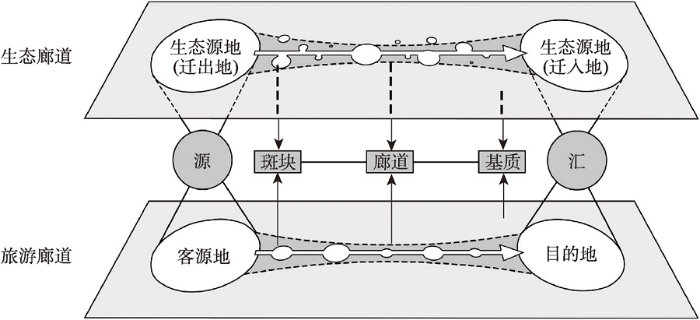
生物迁徙催生生态廊道建构,旅游流动促成旅游廊道形成,两者具有高度的相似性(表1)。从本质上来看,生物迁徙和旅游者迁徙都是基于特定路线,围绕明确目的地进行的空间移动过程。这种迁徙行为通常具有大规模和群体性特征,同时兼具节律性和周期性,因此在空间中表现为生物流、物质流和信息流等多种流。而无论生态廊道还是旅游廊道,都是保障各种流能够正常流动运转的重要物质载体和空间通道。因此,通过对生物流量的监测与模拟,能够有效识别出廊道的构成与走向。
表1 生物迁徙与旅游迁移比较
Tab 1
| 生物迁徙活动 | 旅游者迁移活动 | |
|---|---|---|
| 概念 | 生物为了某种生理需求,周期性地在特定时间,沿着一定的线路进行的集群性长距离移动行为。 | 旅游者在特定时间,沿着一定道路交通线路,在客源地与目的地之间往返的行为。 |
| 性质 | 具有相同生存需求的生物(种群)定向迁徙产生生物流 | 具有近似性旅游需求的旅游者的定向迁移产生客流、信息流、物质流、能量流等 |
| 特征 | 具有固定节律与周期性,受地形地貌、气象灾害、食物水源等环境条件制约 | 具有季节性,受时间精力、安全风险、景观价值、设施服务等因素制约 |
| 规模 | 集群性大规模 | 集体性大规模 |
| 驱动力 | 满足基本生存需求 | 追求精神愉悦与高品质生活需求 |
| 空间结构 | “斑块—廊道—基质”结构 | “客源地—旅游廊道—目的地”结构 |
然而两者的差异主要体现在迁移活动所受到的阻力因素方面。从驱动力层面看,生物迁徙是一种满足基本生存需求的行为,因而迁移阻力因素在景观生态系统中主要体现为连通性,主要考虑迁徙过程中受到的自然环境影响,例如地形地貌障碍、气象灾害风险以及食物和水源充沛情况等。相比之下,旅游活动是一种追求精神愉悦与高品质生活的需求,因此在旅游迁移过程中需要关注旅游者的体验感,旅游者所受到的迁移阻力主要表现为时间、舒适度、安全风险等因素以及旅游基础设施成熟度所产生的旅游偏好。
生态廊道与旅游廊道在地域结构与功能等方面能够很好的相通。从地域构成的角度看,借鉴景观生态学“斑块—廊道—基质”理论(图1),景观生态系统要素主要由生态源地、生态廊道以及背景基质构成[37-38]。而旅游活动中旅游目的地和客源地类似景观生态系统特定斑块,廊道相当于旅游中介,基质则类似旅游活动沿线特殊的自然或人文环境,反映了在空间中受旅游活动利用的地理环境及人文社会特征背景。而根据“源—汇”景观理论,在特定生态空间中,生态廊道是在生态环境中呈线性或带状布局、能够沟通连接空间分布上较为孤立和分散的生态景观单元的景观生态系统空间类型,能够满足物种的扩散、迁移和交换[39]是地域生态系统中对“源”景观与“汇”景观之间物质流、生物流的载体。而旅游廊道也具有相似的功能,因此生态廊道的构建方法能为旅游廊道识别提供理论依据。
图1
2.2.2 旅游廊道识别方法
(1)旅游源地确定。旅游源地既是旅游客源地,也是旅游目的地,是旅游流发生和结束的地方。从性质上来看,旅游源地是旅游设施和服务以及旅游资源在空间中的地域组合,同时也是重要的客流枢纽。而旅游基础设施和服务多依托城镇基础设施建设,因此旅游源地的确定可认为是对旅游资源富集且具有一定旅游服务功能的城镇进行筛选。按照区域内的城镇等级结构,选取一批具有一定等级规模的城镇最为初筛对象,按照区域内旅游资源核密度对城镇的资源富集度进行衡量,以此作为筛选标准,公式如下:
式中:k为核的权重函数,可根据不同类型旅游资源的吸引力进行赋值;h为窗口半径,随区域尺度进行定义;n为样本点个数;xi
(2)旅游阻力评价。物种迁徙所受到的阻力强调了生态廊道的通行阻力,而旅游者的迁移活动除了受制于交通路况、安全风险等因素以外,更强调在迁移过程中的旅游体验。因此本文将旅游迁移阻力分为两个维度,即旅游交通阻力与旅游设施服务成熟度。
旅游交通阻力决定了旅游者在旅游源地间迁移的可行性,是旅游廊道构建的前提与基础。旅游交通阻力评估借鉴了生态阻力面的构建方法,以地理环境为背景,基于不同道路类型与地貌特征对旅游活动的影响对研究区内部进行赋值。而相较于生态阻力面,旅游交通阻力不仅需要考虑旅游迁移活动的通行成本,还需要考虑游客在行进过程中所面临旅游风险、舒适度等因素,也就是说在旅游源地之间迁移过程中所经历的道路等级越高、通行体验越舒适、旅游风险越小,那么所受到的旅游阻力就越低,更易于形成旅游流量。因此旅游交通阻力需要对以上因素进行综合,具体公式如下:
式中:R为特定单元下的综合交通阻力,受该单元内地理环境与社会经济环境影响;t、c、s分别为经过该单元旅游活动的通行成本、舒适度以及安全风险等因素;k为阻力系数,决定不同因子的阻力值大小,通过综合不同阻力因子的阻力值大小得到综合阻力值R。
旅游设施服务的成熟度决定了旅游者在源地间迁移过程中的游憩体验,旅游设施服务越完备,越容易吸引旅游者进行游憩活动,因而旅游阻力越小。旅游设施服务的成熟度计算需要对现有旅游基础设施建设情况进行综合评估,可以在“食、住、行、游、购、娱”六大旅游要素基础上,充分考虑旅游活动的保障条件进行指标体系构建,通过加权最终得到旅游设施服务的综合得分。其中指标权重可通过熵权法求取,公式如下:
式中:n为区段个数;j为某一指标;Yij为标准化以后的数据;Ej为某一指标的信息熵,以得分代表区段旅游基础设施成熟度。
(3)旅游廊道识别。从旅游阻力的分析可见,旅游廊道不仅是旅游源地之间客流交互的通道,其自身也是一种旅游产品。因此旅游廊道识别分为两个步骤:① 基于旅游交通阻力的“旅游交通”网络模拟;② 基于旅游基础设施成熟度的“交通旅游”廊道提取。
首先考虑旅游廊道的通行属性。基于源地与旅游交通阻力,需要对源地间的旅游迁移活动进行模拟以确定源地间可行的旅游路径并形成组织多个旅游源地的旅游交通网络。Circuitscape是基于电路理论建立地域连接度模型的一个开源软件,通过模拟电阻大小、电流大小,最终绘制出源地间最佳网络构成。运用Circuitscape软件对源地与阻力面进行分析,可确定最佳的网络构建方案。考虑到电流通路与最小的成本路径会有一定的偏差,采取ArcGIS中距离分析工具进行进一步验证,并将每一源地进行单独计算,具体计算公式如下:
式中:MCR为游客通过源i出发到达另一源j所消耗的最小成本距离;Dij为板块i到下一斑块j所经历的费用距离;Ri是经过斑块i时的阻力值,进而得到源地间的网络构成。
其次考虑旅游廊道的设施服务成熟度。基于得到的旅游交通网络,基于所构建的指标体系,对网络周边一定范围内的指标要素进行统计与计算得到不同区段旅游设施服务成熟度评价结果。根据每个区段的成熟度、长度等要素设置每个区段的阻抗,在ArcGIS中构建网络数据集。以具有旅游集散功能与门户功能的旅游源地作为起始地,运用最佳路径分析工具提取旅游设施服务最成熟的线路,将其作为最终的旅游廊道识别结果。
3 研究区概况与数据来源
3.1 研究区概况
青藏高原是世界海拔最高的高原,被称为“世界屋脊”“第三极”。青藏高原区地缘辽阔,全域面积约258.28万km2,跨越6个省区,共涉及2个自治区省府以及200多个县市(图2)。本文选择青藏高原作为旅游廊道的典型案例区,主要考虑以下几点:① 青藏高原区旅游业发展迅猛,是中国近年来增速最快的旅游目的地之一。以西藏为例,“十三五”期间游客接待量由2315.94万人次增长至3505.01万人次,增长率高达51.3%。② 自驾车旅游已成为青藏高原最重要旅游方式。据有关部门统计,2021年青藏高原公路客流量占总游客接待量的比例突破80%,以核心交通廊道为依托,形成了G318中国景观大道等中国最具影响力的旅游廊道。③ 跨区域旅游廊道建设成为国家引领西部旅游可持续发展重要战略举措。为推动三区三洲精准扶贫,2019年国家文化和旅游部发展部发布“三区三洲旅游大环线建设方案”,对重塑西部旅游业发展格局,推动旅游业发展建设提出了新要求。
图2

图2
研究区地理环境与交通概况
注:基于自然资源部标准地图服务网站审图号为GS(2019)1822号的标准地图制作,底图边界无修改。
Fig. 2
Geographical background and traffic profile of Qinghai-Tibet Plateau
3.2 数据来源与处理方法
本文所使用的青藏高原范围为TPBoundary_HF(high_frequency),来源于国家青藏高原科学数据中心(
4 结果分析
4.1 旅游源地确定
综合考虑旅游接待服务能力与旅游吸引物富集程度,选取青藏高原区地级市以上具有一定旅游承载能力的城镇作为初筛对象,考虑到青藏高原城镇发展不平衡,西部城镇少而稀疏,如札达、普兰等一些边境旅游城市,旅游资源丰富且具有一定旅游接待能力也应视为旅游源地。因此,为保证研究区内部网络的完整性,基于3A级以上景区核密度结果以县级市为对象对源地进行增补,最终确定旅游源地23个,共涉及青海、西藏、新疆、四川、云南5个省份,其中自治区省府2个,地级市5个,副地级市1个,县级市、区县共15个。
青藏高原各旅游源地核密度分析结果如图3所示。从城镇核密度上看,西宁市(10.162)与拉萨市(8.251)旅游吸引物核密度显著高于其余地区,得分较低城镇分布于拉萨北部与新藏线沿线;从城市级别来看,省会城市旅游吸引物核密度显著高于地级市与县级市,地级市平均核密度(1.307)与县级市平均核密度(1.369)无显著差异;从整体格局来看,旅游吸引物核密度整体呈现“东南高—西北低”的格局,东南部城镇旅游吸引物核密度普遍较高,西部地区旅游源地稀疏且核密度较低。
图3
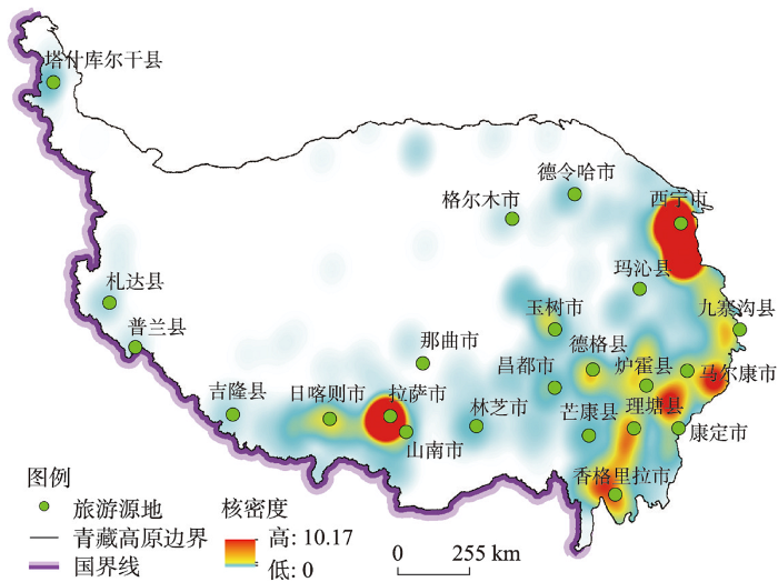
图3
青藏高原旅游吸引物核密度及源地识别结果
Fig. 3
Kernel density estimation of tourist attraction and the result of source identification in the Qinghai-Tibet Plateau
4.2 “旅游交通”网络模拟
4.2.1 “旅游交通”阻力评价
本文选取青藏高原区的通行成本、舒适度以及安全风险作为影响旅游迁移活动的交通阻力因素。通行成本方面主要考虑单元内是否具有高等级公路,以旅游者在不同道路条件下的正常行进速度作为阻力面构建的主要依据。分别选取海拔与坡度代表影响旅游交通活动舒适度与安全风险的阻力情况。考虑到具有交通基础设施地块其通行保障程度较高,坡度与海拔对旅游活动的影响相对较弱,再加上不具有交通属性的单元对一些越野爱好者来说也具有一定通行能力,因此在计算综合阻力值时按照以下原则:若某一地块土地类型为国道、省道、乡道或其他道路,则该地块的阻力值直接以地块的移动速度进行赋值,若该地块不存在任何交通设施,则需要充分考虑地块的坡度与海拔,选取之间阻力最大的值作为该地块的综合阻力,阻力赋值情况如表2所示。
表2 阻力因子及其阻力值
Tab. 2
| 阻力因子 | 亚类 | 阻力值 |
|---|---|---|
| 道路类型 | 国道 | 45 |
| 省道 | 60 | |
| 乡道 | 120 | |
| 其他道路 | 180 | |
| 无道路 | 720 | |
| 坡度(°) | 0~5 | 720 |
| 5~15 | 1080 | |
| 15~25 | 1800 | |
| > 25 | 3000 | |
| 海拔(m) | 0~1000 | 720 |
| 1000~3000 | 900 | |
| 3000~5000 | 1080 | |
| > 5000 | 1800 |
4.2.2 “旅游交通”网络构成
基于以上旅游源地与旅游交通阻力面,本文运用Circuitscape软件(ArcGIS Pro工具箱插件),将线路最大长度设置为2000 km,得到最佳网络构成。针对该网络,运用最小成本路径工具进行路径计算,得到青藏高原旅游网络(图4)。从网络构成情况来看,网络连接率为2.30,环路指数为31,表明该网络呈现典型的回路网络;实际成环率为0.76,实际结合度为0.84,表明该网络构建良好,网络发育完全。
图4
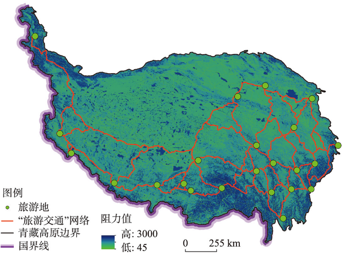
图4
青藏高原“旅游交通”网络构成
Fig. 4
"Tourism transportation" network composition in the Qinghai-Tibet Plateau
4.3 “交通旅游”廊道识别
4.3.1 “旅游交通”网络区段成熟度评价
为探究网络周边旅游基础设施保障程度,以“食、住、行、游、购、娱”六大旅游要素以及旅游医疗保障为基础,构建区段旅游成熟度的评价体系并以熵权法确定权重(表3),结合网络周边10 km为范围各类旅游要素兴趣点(POI)数据,得到了青藏高原“旅游交通”各网络区段的成熟度得分。
表3 旅游设施与服务成熟度指标体系
Tab. 3
| 旅游要素类型 | 指标内涵 | 权重 |
|---|---|---|
| 食 | 茶楼、咖啡厅、甜品店、餐厅、酒楼 | 0.1576 |
| 住 | 星级酒店、宾馆、招待所、青年旅舍 | 0.1485 |
| 行 | 加油站、充电站、加气站、汽车维修、汽车配件、汽车租赁 | 0.1337 |
| 游 | 旅游景点、特色景观、博物馆、动植物园、宗教场所、纪念馆 | 0.0991 |
| 购 | 购物中心、商业街、超市、便利店、市场 | 0.1663 |
| 娱 | 度假区、疗养所、游乐场、剧院影院、酒吧、棋牌 室 | 0.1283 |
| 医 | 综合医院、专科医院、诊所、药店、急救中心 | 0.1665 |
对于各类成熟度指标得分,结果如表4所示。从数值上来看,各廊道得分均值上看,“购”>“吃”>“行”>“住”>“医”>“娱”>“游”,其中购物设施数量略多于餐饮设施,住宿设施服务与汽车相关设施数基本持平。从差异性角度来看,各廊道差异系数:“医”>“购”>“吃”=“住”>“行”>“娱”>“游”,差异最大为医疗基础设施,餐饮条件与住宿条件各廊道差异相当,差异较小的指标为游览设施与娱乐设施。
表4 2022年青藏高原“旅游交通”网络区段的成熟度指标得分情况
Tab. 4
| 吃 | 住 | 行 | 游 | 购 | 娱 | 医 | 总得分 | |
|---|---|---|---|---|---|---|---|---|
| 均值 | 0.175 | 0.175 | 0.170 | 0.228 | 0.160 | 0.200 | 0.142 | 0.175 |
| 标准差 | 0.255 | 0.255 | 0.225 | 0.24 | 0.243 | 0.256 | 0.228 | 0.229 |
| 差异系数 | 1.457 | 1.457 | 1.321 | 1.051 | 1.522 | 1.278 | 1.603 | 1.310 |
青藏高原“旅游交通”网络的旅游设施服务成熟度评价结果如图5所示,结果显示:① 数值上看,各区段得分均值为0.175,中值为0.090,标准差为0.055。得分超出0.700的有5条,均为西宁与周边旅游源地相连接的区段。② 从空间上来看,网络区段得分的具有很强的空间分异,整体呈现东高西底的格局。最为成熟区段分布在西宁周边,较成熟区段分布于雅安市与拉萨市周边。发育最不完全的区域分布于青藏高原西部地区以及中东部地区,即阿里地区与德格县周边地区。
图5
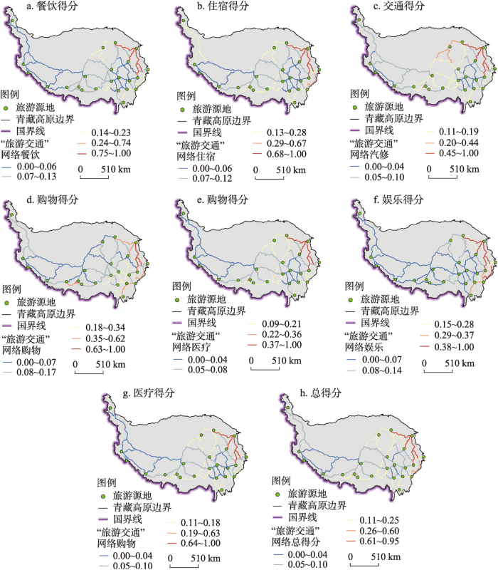
图5
2022年青藏高原“旅游交通”网络区段成熟度得分情况
Fig. 5
"Tourism transportation" network sections score in the Qinghai-Tibet Plateau in 2022
4.3.2 “交通旅游”廊道识别
以青藏高原区具有旅游集散功能(西宁市、拉萨市)以及门户功能(格尔木市、康定市、香格里拉市、塔什库尔干塔吉克自治县)6大旅游源地作为旅游廊道构建的始末点,以区段长度与成熟度的比值作为各区段的阻抗,在ArcGIS中构建网络数据集,运用网络分析工具对旅游廊道进行识别(图6)。
图6
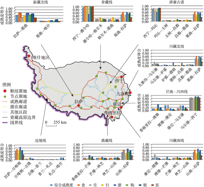
图6
2022年青藏高原旅游廊道识别结果
Fig.6
Tourism corridor identification result in the Qinghai-Tibet Plateau in 2022
共识别出成熟廊道共6条:① 川藏南线以甘孜为进入口连接成都,经过理塘、芒康、林芝、山南最终到达拉萨。全程以318国道为主,仅林芝至拉萨段为S306省道。各区段成熟度相差较小,欠发育区段为理塘至芒康段;② 青藏线以西宁为进入口与客源地,经过德令哈、格尔木、那曲最终到达拉萨。全程与青藏铁路高度重叠,各区段成熟度相差较大,最为成熟区段为西宁至德令哈,欠发育区段为格尔木至那曲段;③ 边境线以塔什库尔干为进入口与客源地乌鲁木齐相连,途径札达、吉隆、日喀则最终抵达拉萨,全程高度依托G219国道。各区段成熟度差异较大,最为成熟区段为拉萨至日喀则,欠发育区段为吉隆至札达段;④ 滇藏线以迪庆为进入口连接客源地昆明,经过芒康、林芝、山南最终到达拉萨。该线路与川藏线西段重叠各区段成熟度相差较小;⑤ 川藏北线以九寨沟为进入口与客源地成都连接,途径阿坝、炉霍、德格、昌都最终抵达那曲,全线以G317国道为支撑,各区段成熟度普遍较低;⑥ 甘南—川西线由迪庆至西宁,穿越丹巴县、马尔康市、玛曲县、同仁县,各区段成熟度悬殊较大,马尔康以北地区得分显著高于南部。
此外考虑到廊道的完整性与部分旅游源地的连通度,按照次最佳原则识别2条具有一定发展潜力的旅游廊道:① 唐番古道线以西宁与拉萨两大客源地作为起始点,途径那曲、玉树、玛多、果洛,与唐代重要西南交通线路具有高度重叠,各区段得分相差悬殊,玛沁至那曲段成熟度较低;② 新藏北线是G317国道向西延展部分,由北向南连接了拉萨、那曲与喀什,沿线景观主体为荒漠,河湖众多,但目前旅游基础设施条件较差,发育不完全。
5 结论与讨论
5.1 结论
(1)旅游廊道识别本质上具有单一功能“旅游交通”线路向具有复合功能“交通旅游”廊道的科学评判过程。研究借鉴景观生态学相关理论,解构“生物迁徙流”和“旅游流”差异特征,分析了从“旅游交通”到旅游廊道构成“交通旅游”产品和产业培育的重要影响因素,确定了识别关键指标,构建了“旅游源地识别—‘旅游交通’网络模拟—‘交通旅游廊道’识别”的方法和路径。从“旅游交通网络”到“交通旅游廊道”提升逻辑看,重点包括:旅游源地构成,主要指客源地或者旅游集散地(包括重点景区和重要集散节点城市);旅游交通网络模拟,重要影响因素有道路交通等级、道路沿线旅游安全风险等;交通旅游廊道识别,重点是沿线旅游公共服务体系和接待服务体系发育保障程度。
(2)青藏高原区研究结论表明,青藏高原区旅游交通网络由23个源地(省会城市2个、地级市5个、县级市16个)和53个区段构成,旅游交通网路表现为回路型网络,并呈现东密西疏格局,网络较密区域位于那曲、昌都、炉霍、理塘、玉树。旅游交通网络设施保障程度评价呈现以西宁、拉萨两大核心城市为中心辐射结构,并向外衰减,各网络区段呈现“医”>“购”>“吃”=“住”>“行”>“娱”>“游”的差异特征,其中西宁周边交通网络区段成熟度最高、雅安市与拉萨市次之,喀什地区与德格县较弱。并最终识别出青藏线、川藏北线、川藏南线、滇藏线、边境线、甘南—川西线6条较成熟旅游廊道,以及新藏北线与唐蕃古道线两条潜在旅游廊道。
(3)旅游廊道识别结果表明,旅游廊道发育程度与区域旅游吸引物格局、城乡发展格局、交通格局、经济社会格局趋于一致,在构建青藏高原旅游空间新格局的同时,在一定程度上也证明了该识别方法的可行性与适用性。
5.2 讨论
大众旅游和自驾车旅游时代到来,旅游廊道规划建设已经成为国家和地方旅游产品升级和旅游产业培育的重要综合性战略举措,特别对于中、西部地域辽阔,人口稀少,以特色自然生态和人文景观环境为核心旅游吸引物,自驾车旅游为主导的地区更是具有特殊重要意义。推动传统“旅游交通”向“交通旅游”提升,加大廊道型“交通旅游”产品建设,实现旅游产业的廊道化集聚,已成为旅游业高质量发展的重要目标。
从发展角度看,区域和跨区域旅游廊道是旅游业发展大众旅游时代到来和自驾车旅游全面兴起的产物。对于现代旅游活动而言,旅游活动的主体是旅游者,旅游客流是旅游流的核心,并伴随旅游信息流、物流、能流的生产,并形成特有运动模式,在特定时间内有着特定流向与流量[40]。旅游业发展不同阶段,旅游流有着不同类型或者空间尺度特征。早期观光旅游阶段,对旅游流研究侧重跨国旅游或特定国家跨区域旅游流动以及影响因素研究[41-42]。这种流动以长距离、团队化旅游方式为主,其主导交通方式以公共交通服务(飞机、旅游大巴)为主,这种不连续性、被安排交通组织,不涉及到“旅游廊道”建设问题。大众旅游阶段,休闲度假成为旅游活动主要目的,自驾车主导自助式旅游成为核心,这也不断催生传统“旅游交通”逐步向“交通旅游”提升。
当然,对于旅游廊道识别研究目前尚未见成型报道。本文借鉴景观生态学中生态廊道识别理论方法,结合现代自驾车旅游活动一般规律,构建了能够定量识别与评价旅游廊道的理论与方法,并以青藏高原为案例区进行实证研究,考虑到旅游廊道理论构建的一般性,评价指标选建的普适性、评价方法的成熟性,整体认为在以省域为基本单元的区域或跨区域层面是可行的。
而旅游廊道是一个相对宽泛的概念,旅游交通沿线地域社会经济差异、自然人文景观差异以及旅游需求差异的普遍存在,使得不同时空尺度下旅游者与旅游交通耦合互动过程与层级传导机制呈现出复杂性与非线性动态演化特征,致使旅游廊道在不同情景下具有不同的空间组合特征。但从本质上来看,旅游廊道服务于旅游者,而旅游迁移活动的往返性、周期性、集群性等基本特征未发生实质性的改变,旅游廊道仍然是旅游迁移所产生旅游流的基本载体。因此本文围绕旅游主体所构建的“旅游源地确定—‘旅游交通’网络模拟—‘交通旅游’廊道识别”的识别路径在不同尺度、不同特定功能的旅游廊道识别上具有借鉴意义。而这也要求我们不断结合旅游需求,不断深化对旅游廊道研究,丰富和完善旅游地理学研究理论方法,形成对旅游廊道这一旅游空间现象的科学认知。
关联数据信息:本文关联实体数据集已在Science Data Bank出版,获取地址:
参考文献
Literature review on scenic byway research and planning practice
DOI:10.11821/yj2007060021
[本文引用: 2]

This paper firstly reviews the theoretical study abroad on scenic byway, and discusses the development of practical work in foreign countries from the prospective of American national scenic byway plan and national scenic byway system. Secondly, according to the feature that our research on scenic byway is accompanied by local planning, the paper analyzes the practice of scenic byway in China through several cases of scenic byway planning. The preliminary theoretical research of different subjects on scenic byway, greenway and heritage corridor from respective point of disciplines background is also discussed, be combining mostly with the production tasks. Finally, this paper points out that both theoretical research and practice in China is still at the initial stage, management organization should be established, research and practice in this field should be actively carried out, and construction of national scenic byway system should be also discussed and concluded.
风景道研究与规划实践综述
The development features and influence of tourism corridors under the holistic tourism background
全域旅游背景下旅游廊道的发展特征及影响研究
The 13th Five-year Plan for Tourism Development
http://www.gov.cn/zhengce/content/2016-12/26/content_5152993.htm, 2016-12-26.
“十三五”旅游业发展规划
http://www.gov.cn/zhengce/content/2016-12/26/content_5152993.htm, 2016-12-26.]
National Ecotourism Development Plan (2016-2025)
http://www.gov.cn/gongbao/content/2017/content_5194900.htm, 2016-08-22.
全国生态旅游发展规划(2016—2025年)
http://www.gov.cn/gongbao/content/2017/content_5194900.htm, 2016-12-26.]
The 14th Five-year Plan for Tourism Development
http://www.gov.cn/zhengce/content/2022-01/20/content_5669468.htm, 2021-12-22.
“十四五”旅游业发展规划
http://www.gov.cn/zhengce/content/2022-01/20/content_5669468.htm, 2021-12-22.]
Tourism corridor: Concept system, development process and research progress
旅游廊道: 概念体系、发展历程与研究进展
Introduction and overview: The greenway movement, uses and potentials of greenways
DOI:10.1016/0169-2046(95)02035-R URL [本文引用: 1]
Perception and use of a metropolitan greenway system for recreation
DOI:10.1016/0169-2046(94)02031-A URL [本文引用: 1]
Importance of scenic byways in route choice: A survey of driving tourists in the United States. Transportation Research
Greenway use and preferences in diverse urban communities: Implications for trail design and management
DOI:10.1016/j.landurbplan.2017.12.007 URL [本文引用: 1]
Urban greenway and compact land use development: A multilevel assessment in Seoul, South Korea
DOI:10.1016/j.landurbplan.2015.07.010 URL [本文引用: 1]
Multi-criteria spatial decision analysis for demarcation of greenway: A case study of the city of Rio Claro, São Paulo, Brazil
DOI:10.1016/j.landurbplan.2007.09.006 URL [本文引用: 1]
Scenic values of the Katowice-Częstochowa section of National Road No.1
DOI:10.7163/GPol URL [本文引用: 1]
Public participation GIS for assessing landscape values and improvement preferences in urban stream corridors
DOI:10.1016/j.apgeog.2017.08.009 URL [本文引用: 1]
The relationships between weather-related factors and daily outdoor physical activity counts on an urban greenway
DOI:10.3390/ijerph8020579
PMID:21556205
[本文引用: 1]
The purpose of this study was to examine relationships between weather and outdoor physical activity (PA). An online weather source was used to obtain daily max temperature [DMT], precipitation, and wind speed. An infra-red trail counter provided data on daily trail use along a greenway, over a 2-year period. Multiple regression analysis was used to examine associations between PA and weather, while controlling for day of the week and month of the year. The overall regression model explained 77.0% of the variance in daily PA (p < 0.001). DMT (b = 10.5), max temp-squared (b = -4.0), precipitation (b = -70.0), and max wind speed (b = 1.9) contributed significantly.Aggregated daily data can detect relationships between weather and outdoor PA.
The impacts of building a greenway on proximate residents' physical activity
Heritage corridor and a primary theoretic framework on study of integ rated conservation of the great canal
遗产廊道与大运河整体保护的理论框架
The definition of the Grand Canal heritage corridor based on the genesis perspectives
DOI:10.11820/dlkxjz.2010.08.011
[本文引用: 1]
<p>The heritage corridor approach is a regional methodology for heritage protection of large scale cultural landscapes. Combining the regional heritage protection strategy and the greenway approach, the heritage corridor approach places emphasis on the historical values, in conjunction with ecological and economical values. The Grand Canal is one of the most important cultural heritages in China dating back more than 2500 years to the late Spring and Autumn Period. The Grand Canal is the longest and oldest man-made canal in the world with a total length of over 1700 kilometers. Many heterogeneous components overlap forming an intricate system. Therefore, identifying the composition of the heritage corridor is the first step for the long-term protection and management of the natural and cultural elements of the Grand Canal. In connection with the distinct space-time background, the genesis method focuses on dynamic modeling analyses of the constructing process. This approach is effective in illustrating the components and their interrelation to the complex system, so that we can identify the components which have close relations to the development of the Grand Canal. Genesis analysis visualizes the evolution of the Grand Canal Heritage Corridor and the function and interaction of its various components. Based on genesis analysis, the Grand Canal Heritage Corridor is composed of three major systems: natural system, cultural heritage system and supporting system. The natural system includes regional landscape features such as wetlands, forests, and farmlands to constitute the physical settings of the corridor. The cultural heritage system includes traditional hydrological engineering services such as water courses, water sources, transportation and distribution utilities related to the corridor’s hydraulic functions. The cultural heritage system includes both tangible heritages such as ancient buildings, sites, canal settlements and intangible heritages such as folklore, poems and traditional performance art. The supporting system consists of trails, interpretive systems and public service facilities. These three systems are integrated to form the natural, cultural and social properties of the Grand Canal, and are indispensable for the sustainable development of the Grand Canal heritage area. The Grand Canal Heritage corridor is a living system that provides diverse services of production, regulation, life support, recreation, education and aesthetic appreciation.</p>
发生学视角下的大运河遗产廊道构成
Edvate: A linear landscape evaluation technique: A case study on the Xiaoxinganling Scenery Drive
小兴安岭风景道旅游景观评价
DOI:10.11821/xb200102010
[本文引用: 1]
在黑龙江省伊春市进行国内第一条驾车旅游观光风景道规划设计过程中,从旅游者体验风景道品质的特定要求出发,建立一种简单易行、科学经济的旅游景观评价方法,即称之为“等距离专家组目视评测法” (EDVAET)。在实地观测评价基础上,建立由地形、视觉质量、视域、景观被及沿途典型景观照片构成的景观数据库。并分别对景观被分类分段评价、视质评价、视域评价进行分析。不仅提供了一种线性旅游景观评价的适用技术,也为风景道规划设计提供了科学依据。
Study on measurement of seasonality and its regional differences of self-driving tours market in China
我国自驾游(跨市)市场季节性测度及其地域差异
A study on the behavior of self-driving tourists in China
我国自驾车旅游者行为研究: 以华北地区为例
Temporal and spatial characteristics of self-driving tourist flows based on tourism digital footprints: A case study in Yunnan province
基于数字足迹的自驾车旅游客流时空特征研究: 以云南省为例
A study on the spatial travel behavior of self-driving tourists into Huangshan city
DOI:10.11821/yj2013010018
[本文引用: 1]
Taking Huangshan City as the study area, the paper studies the spatial travel patterns of self-driving tourists inside a tourism destination. It can be concluded as follows. (1) There are three market characteristics of self-driving tourists: an adjacent character, a clear character for eastbound development and the character concentrated on the 4-hour drive. In the flow of self-driving tourists into Huangshan City, those who come from Anhui Province and Yangtze River Delta account for 76.6%. (2) The tourism spacial use curve of self-driving is consistent with curves of Boltzman. The number of tourists increases with distance and peaks at 400 km, then, the number of tourists shows a rapid decrease. On the whole, its gravity field concentrates on the scope of 600 km, and the accumulation percentage of tourists reaches 79.37%. (3) Spatial travel behaviors of self-driving tourists into Huangshan City are shown in the following: the highways constitute the skeleton of the traffic of self-driving tourism into Huangshan City, self-driving forms the prominent center for the accumulation in the district, the traffic flow shows the regional unbalance evidently, and spatial interaction between scenic sites has an impact on the spatial behavior of self-driving tourists. (4) The spatial pattern of self-driving tourism into Huangshan City are mainly taken as the forms of "single destination" (64%)", "transit leg and circle tour" (12%), and some others take up 12%, and a completely round-route pattern has not been found.
黄山市自驾车入游流旅行空间行为研究
Evaluation of tourism dynamic landscape along Qinghai-Tibet Railway based on the visual corridor
基于视觉廊道的青藏铁路沿线旅游动态景观评价
Tourism planning for the scenic speedway based on landscape evaluation: a case study on Funing scenic speedway
基于景观评价的高速公路风景道旅游规划: 以福宁高速风景道为例
Establishment and application of indexes of qualitative evaluation of tourism value for heritage corridor: A case study on the Jiangsu section of the Grand Canal
遗产廊道旅游价值评价体系构建及其应用研究: 以古运河江苏段为例
Travel risk evaluation along the Qinghai-Tibet Railway
青藏铁路沿线旅游安全风险评价
Climatic suitability for tourism along the Qinghai-Tibet Railway
青藏铁路旅游线气候适宜性分析
Research on the risk cognition in self-drive tourism
居民自驾游风险认知研究
Research on ecotourism carrying capacity of the "Belt and Road" heritage corridor based on state space model
基于状态空间模型的“一带一路”遗产廊道生态旅游承载力研究
Research on ecological scenic byways planning couple with multiple values: Taking Ulanqab four horizontal traffic belt as an example
耦合多元价值的生态风景道规划研究: 以乌兰察布四横交通带风景道为例
Evaluation and spatial pattern of farmers' livelihood capital in corridor-type rural tourism areas: A case study of the Dabie Mountain national landscape
DOI:10.13249/j.cnki.sgs.2021.02.017
[本文引用: 2]
Taking the Dabie Mountain National Landscape as an example, this article constructs an evaluation index system of farmers’ livelihood based on DFID sustainable livelihood analysis framework and case study, and analyzes the spatial distribution differences and influencing factors of farmers’ livelihood capital in corridor rural tourism. The results show that: 1) The visible livelihood capital, such as natural capital, has a higher weight in the tourism corridor of Dabie Mountains, while the intangible livelihood capital, such as social capital, has a lower weight. Five indicators of livelihood capital weights: Natural capital>financial capital> physical capital>human capital>social capital. The five comprehensive scores of livelihood capital: Natural capital>physical capital>financial capital>human capital>social capital. 2) Farmers’ livelihood capital in corridor-type rural tourism areas has obvious characteristics of unbalanced spatial distribution.The overall level of farmers’ livelihood capital: Jinzhai County > Huoshan County, the five livelihood capital show strong spatial differences. There are also obvious spatial differences in the total level of farmers’ livelihood capital and the five livelihood capital levels in the villages and townships. 3) The unbalanced spatial distribution of farmers’ livelihood capital is affected by core scenic spots, main roads, maturity of local industrial forms, government policies. The overall level of farmers’ livelihood capital is higher in the core scenic spots or near the main roads. Influenced by the diversity of industrial formats and the stage of tourism development, two tourism agglomeration zones have been formed around Tiantangzhai and Baimajian scenic spots. The effect of tourism agglomeration is obvious, but the radiation scope is limited, and the driving force of the impact on the surrounding areas is insufficient. The difference of government’s policies leads to the change of livelihood mode and livelihood capital of farmers in different rural communities.
廊道型乡村旅游地农户生计资本评价与空间格局特征: 以大别山国家风景道为例
DOI:10.13249/j.cnki.sgs.2021.02.017
[本文引用: 2]
以大别山国家风景道为例,借鉴DFID可持续生计分析框架,构建农户生计评价指标体系,分析廊道型乡村旅游地农户生计资本的空间特征及影响因素。研究发现:① 大别山旅游廊道内自然资本等有形生计资本权重较高,社会资本等无形生计资本权重较低。② 农户生计资本具有较为明显的空间分布不均衡的特征,各乡镇以及乡镇内各村的农户生计资本水平也存在明显的空间差异。③ 农户生计资本空间分布的不均衡受到核心景区、主干公路、当地产业业态成熟度、政府政策等因素的影响较为明显。
Landscape ecological connectivity assessment of Shenzhen city
深圳地区景观生态连接度评估
Analysis of the landscape-level connectivity of the Yunnan snub-nosed monkey habitat based on circuit theory
基于电路理论的滇金丝猴生境景观连通性分析
Identification of ecological corridors and its importance by integrating circuit theory
DOI:10.13287/j.1001-9332.201610.035
[本文引用: 1]
Landscape connectivity is considered as an extraordinarily important factor affecting various ecological processes. The least cost path (LCP) on the basis of minimum cumulative resis-tance model (MCRM) may provide a more efficient approach to identify functional connectivity in heterogeneous landscapes, and is already adopted by the research of landscape functional connecti-vity assessment and ecological corridor simulation. Connectivity model on circuit theory (CMCT) replaced the edges in the graph theory with resistors, cost distance with resistance distance to measure the functional connectivity in heterogeneous landscapes. By means of Linkage Mapper tool and Circuitscape software, the simulated landscape generated from SIMMAP 2.0 software was viewed as the study object in this article, aimed at exploring how to integrate MCRM with CMCT to identify ecological corridors and relative importance of landscape factors. The results showed that two models had their individual advantages and mutual complement. MCRM could effectively identify least cost corridors among habitats. CMCT could effectively identify important landscape factor and pinch point, which had important influence on landscape connectivity. We also found that the position of pinch point was not affected by corridor width, which had obvious advantage in the research of identifying the importance of corridors. The integrated method could provide certain scientific basis for regional ecological protection planning and ecological corridor design.
整合电路理论的生态廊道及其重要性识别
DOI:10.13287/j.1001-9332.201610.035
[本文引用: 1]
景观连接度被认为是影响诸多生态过程的一个重要因素.基于最小累积阻力模型的最小成本路径识别方法可以有效识别异质性景观中的功能连接,已被广泛应用到景观的功能连接评价与生态廊道模拟的研究中.基于电路理论的连接度模型用电阻代替了图论中的边、用电阻距离代替成本距离,来衡量异质性景观的功能连接.本文以SIMMAP 2.0软件生成的模拟景观为对象,借助于Linkage Mapper工具和Circuitscape软件,探讨如何将最小累积阻力模型与基于电路理论的连接度模型相结合来识别生态廊道及其景观要素的相对重要性.结果表明: 两种模型在应用中各有优势,互为补充.最小成本路径方法可以有效识别栖息地之间的最小成本廊道,基于电路理论的连接度模型通过电流密度的计算可以有效识别对景观连接性有重要影响的景观要素和“夹点”地区,并且“夹点”的位置不受廊道宽度的影响,在廊道重要性识别研究中具有明显优势.该方法可为区域生态保护规划和生态廊道设计提供科学依据.
The logic transformation of the scenic byway system to the linear experience space transformation
DOI:10.31497/zrzyxb.20200204
[本文引用: 1]
From the perspective of traveling experience, the scenic byway is no longer the only tourist transit or tourism passage as experiencing scenic byways has become a new travel motive, which reflects the spatial mobility of tourism industry elements. Regarding "on the road" traveling experience as the major travel motivation of tourists, this paper believes that the scenic byway system performs the function of direct expression of tourists traveling experience rather than the traditional tourism highway system that transits tourist flow. Recognizing the scenic byway system as a special derived form of tourism destination, the paper analyzes the rationality of scenic byway system as a new linear experience space and expounds the theoretical analysis of this derived form of tourist destination. Their characteristics are summarized using relevant domestic and international case studies. Taking the Tongling- Huangshan section of the Beijing-Taiwan Expressway in southern Anhui as an example, this paper explores the necessity and importance of developing the scenic byway in the region, proposes the construction components of linear tourism experience space and summarizes the differences in development connotation. The introduction of the linear experience space profoundly expands the existing tourism research on the scenic byway system and provides a new direction for tourist destinations development.
线型旅游体验空间: 风景道的体验性逻理嬗变
DOI:10.31497/zrzyxb.20200204
[本文引用: 1]
在体验视角下,风景道不仅只是旅游系统中的旅游过境地或旅游通道,旅游者逐渐将体验特色风景道作为出游动机,同时也折射出旅游产业要素在沿线空间范围上的流向扩散。在将“在路上”这一旅游体验作为旅游者出游的主要动机,使传统意义上仅以交通功能承载旅游流的风景道转向为旅游者体验最直接的表现形式,并将其整体视为一种特殊类型的旅游目的地衍生形态,不仅可以串联各自区隔的旅游空间,还是我国建立国家公园体系的有效支撑,同时也符合全域旅游发展的内在需求。通过对风景道作为新型线性体验空间的合理性进行分析,阐述这种旅游目的地衍生形态的理论解析,并结合国内外相关案例对其特点特征进行总结。以安徽南部京台高速铜黄段为例,探讨打造该区域的必然性与重要性,提出线型旅游体验空间构建内容,并总结发展内涵上的差异性。线型旅游体验空间的提出,在理论上深化拓展了现有关于风景道的旅游研究,为现实中旅游目的地发展提供一个新的发展方向。
Land Mosaics
Source-sink landscape theory and its ecological significance
“源”“汇”景观理论及其生态学意义
Study on tourism flow system
旅游流体系研究
The characteristics and dynamical factors of Chinese inbound tourist flow network
DOI:10.11821/xb201008012
[本文引用: 1]
Tourist flows could be taken as inherent relations among destinations. It is necessary and feasible to analyze the inbound tourist flows from the view of network, and that would be more theoretical and practical significance to tourist flow study. This paper not only defines the notion of tourist flows network in theory, discusses its significance, but constructs an assessment model of tourist flows network, and uses characterization, density, E-I indictor, centralization, cohesive subgroup and core-periphery, which are from the Social Network Analysis, into the analysis of Chinese inbound tourist flow network as well. Then this paper tries to find out the dynamical factors on tourist flows among provinces by using QAP regression and correlation, which are stemmed from SNA too and better than OLS analysis to some extent in matrix analysis. It is concluded that the inbound tourist flow scale presents a decreasing trend from the Eastern, the Western, the Northeast, to the Midland of China. The whole network is loosely organized and unbalanced. Some eastern provinces not only possess higher centralization and structural dominance, but also closely connect with each other. Furthermore some western provinces have become more important in network, and the regional imbalance of inbound tourist flow network has been narrowing. The natural tourism resource, provincial economic position, foreign relation and spatial distance are major constraints to inbound tourist flows, and the numbers of international travel agencies and flights which are representatives of high quality service and top grade, whether they are in the same region or not, contribute to the tourist flow. By doing all of these, this paper aims at offering a new method for inbound tourist flow research and assisting the formulation of tourism policies at national and provincial levels.
中国入境旅游流网络结构特征及动因研究
DOI:10.11821/xb201008012
[本文引用: 1]
从旅游流的内在联系特性入手,分析了入境旅游流网络分析的可行性和必要性,采用基本特征描述、密度分析及EI 指数检验、中心性、凝聚子群、核心—边缘分析等分析方法对中国入境旅游流网络展开研究,然后运用QAP分析模型对旅游者流动矩阵和各省市旅游供给要素差值矩阵进行相关和回归分析。结果显示:① 中国入境旅游流规模上呈现东部强,西部、东北次强,中部弱的态势,整体结构比较松散而且不均衡,空间结构上出现一定的集群 现象;② 东部一些省市不仅中心度指数高,结构优势明显,占据网络的核心位置,而且内部联系紧密,另外西部个别省份的网络重要性有所增强,旅游发展的不均衡态势有所改善;③ 自然资源因素、经济发展水平、对外联系度、空间距离是制约入境旅游者流动的因素,而国际旅行社数、飞机起降架次为代表的高档次旅游服务水平、及是否同一地区是影响旅游者选择旅游地的重要因素。文章旨在为探讨入境旅游流空间特征和机制提供一种新的分析思路, 力求能从宏观上把握中国入境旅游流特征,进而为入境旅游的均衡发展和各省市旅游政策的制定等宏观决策提供理论层面的参照。
An analysis on spatial field effect of domestic tourist flows in China
DOI:10.11821/yj2005020016
[本文引用: 1]
<p>Based on the data of tourism sampling check from 1999 to 2003 in China, and in the context of spatial field effect,this psper uses factor analysis to show the basic character of domestic tourist flows origin, distribution, centralization, decentralization and their relativity of tourist flows spatial network. The results are as follows: (1) Economy is the main driving force of the tourist flows origin, the effect of cultural driving force is intensifying and tourist resource is the main driving force of the tourist distribution. Now, China has formed four tourist flows original fields and five tourist destinations. (2) Influenced by market principle, the hierarchical structure of tourist centralization fields and decentralization fields represents the spatial sequence model of K = 3. (3) The regional structure of tourist centralization fields show the character of "U" form, and the regional structure of tourist decentralization fields represent the pattern of "third class ladder". (4) The spatial network indexes of β and γ indicate that the relativity of tourist flows spatial network is feebleness. Finally, the paper regards that China should expedite the tourism development of the "two zones & three regions", namely the two zones of the Yangtze and Yellow river drainage areas and the three regions of the south coastal provinces, the north coastal provinces and northeast provinces in China. They are the key directions to push energetically the cooperation among tourist regions, endeavor to construct the tourist spatial network system, adjust and optimize the directions and quantity of tourist flows, as well as the key factors to enhance the network level of tourist flows.</p>
中国国内旅游流空间场效应分析
