

1 引言
怒江是中国西南一条重要的国际河流(图1),面积约13.6万km2,多年平均径流量703亿m3 [12]。流域上游深入青藏高原东南腹地,以念青唐古拉山—伯舒拉岭为界与雅鲁藏布江相邻;下游纵贯横断山区西部,以高黎贡山为界与伊洛瓦底江毗邻。特殊的区位使其降水深受印度季风影响[13],空间异质性显著。杜军、樊辉等利用气象站长时序逐月降水量数据,对怒江流域降水空间格局和变化特征进行研究,并讨论了经纬度和海拔对降水的影响[14-15];李蒙等基于TRMM 3B42 V7降水数据分析了怒江上游降水特征[16];目前,尚缺乏水汽输送对降水影响的探讨。高登义[17]指出该区山地水汽屏障和通道作用同时存在,两者综合作用形成特殊的水汽输送结构和降水分布。本文采用0.25°高分辨率ERA-Interim再分析资料、SRTM V4.1 DEM数据,通过一种新的流域边界水汽通量概化和提取方法,揭示出山地“水汽屏障和通道”作用下,怒江流域水汽输送具有多支特征;并结合站点实测资料、TRMM 3B43 V7降水数据,分析了多支水汽输送对降水时空分异的影响。
图1
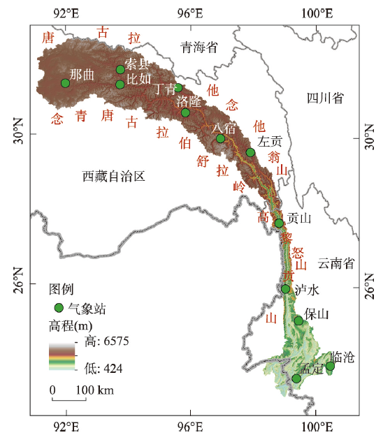
图1
怒江流域区位及气象站点分布
注:基于自然资源部标准地图服务网站GS(2020)4619号标准地图制作,底图边界无修改。
Fig. 1
Location of the Nujiang River Basin and meteorological stations
2 研究区概况与研究方法
2.1 研究区概况
怒江发源于青藏高原唐古拉山南麓,其河源那曲(洛隆县以北)河谷宽广,海拔大都在4500~5000 m,山峰在5500 m以上,年降水量在500~700 mm。干流过洛隆县后,流域渐窄,河流深切,谷地海拔多在3000 m以下,山峰多在4500 m以上;区域年降水在270~500 mm,是流域降水最少的地区之一。过左贡县后,流域在高黎贡山和怒山的夹持下进一步收窄,山峰海拔在3500 m以上,谷底海拔在1000~2500 m,北部贡山一带雨量丰沛,年降水在1700 mm左右,南部在950 mm左右。干流向南过泸水后,地形渐低且开阔,北部山峰高程一般在2000~2500 m,南部山峰海拔降至1500 m以下,河床海拔600 m以下;年降水大都介于1000~1600 mm间,下游边境一带山地年降水可达2000 mm以上[12]。
2.2 数据来源
2.2.1 ERA-Interim再分析资料
已有研究表明,ERA-Interim再分析资料能较好地刻画青藏高原及周边地区夏季水汽输送情况[11]。选取1979—2017年欧洲中期天气预报中心(ECMWF)推出的0.25°×0.25°高空间分辨率逐月平均ERA-Interim再分析资料(
2.2.2 气象资料
表1 怒江流域气象站点
Tab. 1
| 站点 | 高程(m) | 起止年份 | 站点 | 高程(m) | 起止年份 | 站点 | 高程(m) | 起止年份 |
|---|---|---|---|---|---|---|---|---|
| 孟定 | 5114 | 1979—1990 | 贡山 | 1583 | 1979—2017 | 丁青 | 3873 | 1979—2017 |
| 临沧 | 1502 | 1979—2017 | 左贡 | 3780 | 1979—2017 | 比如 | 3940 | 1991—2017 |
| 保山 | 1652 | 1979—2017 | 八宿 | 3260 | 1991—2017 | 索县 | 4023 | 1979—2017 |
| 泸水 | 1805 | 1979—2002 | 洛隆 | 3640 | 1992—2017 | 那曲 | 4507 | 1979—2017 |
2.2.3 TRMM 3B43 Version7数据
TRMM 3B43为月降水数据,空间分辨率为0.25°×0.25°,存储格式为HDF格式,数据记录的是每月的平均每小时降水量(mm/h),最新版本Version7于2012年5月22日发布,数据下载自the Goddard Earth Sciences Data and Information Services Center(
2.2.4 SRTM Version4.1 DEM数据
Shuttle Radar Topography Mission(SRTM)Version 4.1 DEM数据,为最新修订版本,由国际热带农业中心(International Centre for Tropical Agriculture, CIAT)利用新的插值算法进行了处理,并基于辅助数据对无值区域做了填充;数据空间分辨率90 m,下载自
2.3 研究方法
2.3.1 整层水汽通量和水汽通量散度
垂直积分水汽通量计算公式如下:
式中:g为重力加速度(m2/s);
水汽通量散度计算公式如下:
2.3.2 流域边界水汽通量的概化和提取
已有研究在开展水汽输送特征分析时,常采用“箱体”模型[7]或区域外包正多边形[18]对流域边界进行概化处理。怒江流域形状不规则且地形变化剧烈、水汽输送空间异质性强,现有方法并不适用。本文提出一种新方法进行流域边界(分水岭脊线)上空水汽通量的概化和提取:① 选用0.25°×0.25°高空间分辨率ERA-Interim再分析数据,基于公式(1)计算得到研究区地表至100 hPa的整层水汽通量栅格数据。② 基于SRTM V4.1 DEM提取得到流域矢量边界(分水岭脊线)数据。③ 将流域矢量边界和水汽通量栅格数据进行叠加分析,提取与矢量边界相交的水汽通量栅格值。通过该方法提取的水汽通量沿流域边界分布大致均匀,每隔0.25°就有一个值。
2.3.3 TRMM降水数据处理及统计
利用怒江流域矢量边界数据,对1998—2015年共216幅的TRMM 3B43 Version7月降水数据进行批量裁剪,得到流域范围内212个0.25°×0.25°的降水栅格数据。将TRMM 3B43 Version7月平均小时降水量(mm/h)转换成月降水量(mm),统计得到流域多年平均夏季(6—8月)降水数据。
此外,本文中还使用了皮尔逊相关分析(t检验)、非线性函数拟合及时间序列趋势分析等统计分析方法[19]。
3 流域水汽输送特征
3.1 流域水汽输送的多支特征
图2
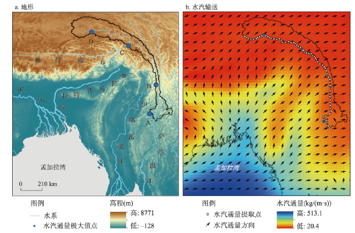
图2
1979—2017年怒江流域多年平均夏季水汽输送背景场和区域地形
Fig. 2
Background field of summer water vapor transfer of Nujiang River Basin from 1979 to 2017 and the topography
图3
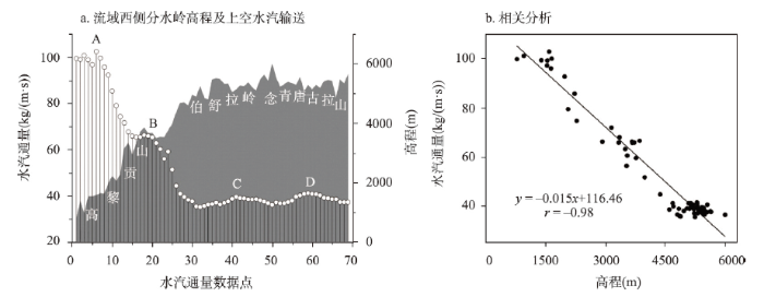
图3
夏季怒江流域西侧分水岭水汽通量、高程沿程变化及两者相关分析
Fig. 3
Variations of water vapor input and elevation along the western boundary of the Nujiang River Basin in summer and their correlation analysis
流域西侧分水岭高黎贡山段(点1~31)位于横断山区西侧,平均高程3027 m,平均水汽通量70.5 kg/(m·s);水汽输送的两个极大值分别位于高黎贡山南部(A点:98.170°E、23.700°N,水汽通量102.6 kg/(m·s))和高黎贡山北部(B点:26.374°N、98.730°E,水汽通量66.3 kg/(m·s));该段高程自南向北迅速攀升,水汽输送不断减小,向北至与伯舒拉岭结合处仅35.3 kg/(m·s),是流域水汽输入最小的地区。流域分水岭伯舒拉岭—念青唐古拉山段(点32~69)位于青藏高原东南部,平均海拔4935 m左右,平均水汽通量38.2 kg/(m·s);该段高程和水汽输送变化相对平稳,两个水汽输送极大值点分别位于伯舒拉岭北部(C点:30.016°N、96.261°E,水汽通量39.7 kg/(m·s))和念青唐古拉山中部(D点:92.973°E、31.278°N,水汽通量41.3 kg/(m·s))。
分析发现,流域西侧分水岭上空水汽通量与高程具有显著负相关关系(图3b),即分水岭高程越大的地区,输入的水汽强度越小。可见,西侧分水岭高程是影响水汽通量大小和形成多支输送特征的关键制约因素。此外,怒江流域南北纵贯10个纬度,纬度越高距水汽源地越远,输送路径也各异。结合图2b和图2a可见,怒江流域青藏高原区的水汽(C支、D支),主要源自经青藏高原南缘有利地形进入青藏高原[8],而后向东北越过念青唐古拉山—伯舒拉岭的水汽输送;流域横断山区的水汽(A支、B支)主要源自沿伊洛瓦底江河谷向高纬输送,而后在青藏高原东南缘转向[7]进入流域的水汽输送。因此,流域不同地区纬度差异导致的距水汽源地远近及水汽输送路径差异,也是造成水汽输送强弱差异的重要原因。
3.2 多支水汽输送年际变化及影响区域
表2 1979—2017年夏季怒江流域各支水汽输送 序列相关分析
Tab. 2
| 水汽输送 | A支 | B支 | C支 | D支 | 均值(kg/(m·s)) |
|---|---|---|---|---|---|
| A支 | 1.0 | 0.74** | 0.32* | 0.27 | 102.6 |
| B支 | 1.0 | 0.68** | 0.57** | 66.3 | |
| C支 | 1.0 | 0.86** | 39.7 | ||
| D支 | 1.0 | 41.3 |
注:*通过0.05显著性检验,**通过0.01显著性检验。
图4
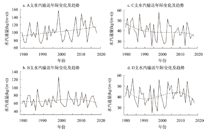
图4
1979—2017年夏季怒江流域4支水汽输送年际变化曲线及趋势
Fig. 4
The interannual variation and trend of water vapor transport of the Nujiang River Basin in summer during 1979-2017
夏季怒江流域水汽主要自西侧边界输入,具有多支特征。为分析A支、B支、C支、D支水汽输送各自的影响区域,将各支水汽输送年际变化序列分别与不同地区(站点)的水汽输送序列进行相关分析。通过比较相关系数大小,结合地理分布情况,使用泰森多边形法界定各支水汽输送的影响区域(图5a),结果表明:A支水汽输送主要影响包括孟定、临沧、保山的下游地区,B支水汽输送主要影响包括泸水、贡山的峡谷地区,C支水汽输送主要影响青藏高原东南的左贡、八宿、洛隆一带,D支水汽输送则主要影响包括那曲、比如、索县、丁青的上游地区。对比分析各影响区(相关站点)的水汽输送年际变化曲线(图5b),发现:不同影响区(站点)水汽输送年际变化与各支水汽输送的变化基本一致,两者相关系数介于0.85~0.99间,均通过α = 0.01显著性检验。且各影响区内,距水汽输入通道(A点、B点、C点、D点)越近的站点,相关系数越高,水汽输送强度也越大,如A支影响区的孟定站(相关系数r = 0.94)、B支的泸水站(r = 0.95)、C支的八宿站(r = 0.99)和D支的那曲站(r = 0.99),均强于同一影响区内的其他站点。
图5
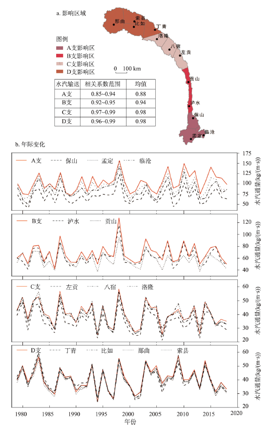
图5
1979—2017年4支水汽输送影响区域和怒江流域各地夏季水汽输送年际变化曲线
Fig. 5
Impact area of each water vapor transport and interannual variation curve of summer water vapor transport in different areas of the Nujiang River Basin during 1979-2017
4 多支水汽输送对降水的影响
4.1 多支水汽输送对降水年际变化的影响
为评估多支水汽输送年际变化对降水的影响,将各支水汽输送序列与其影响区域(站点)的降水序列做相关分析,发现两者相关性地区差异明显(图6)。下游地区(孟定站、临沧站和保山站),降水和A支水汽输送年际变化的相关性较弱。随高程增大,相关系数近似以指数关系增大,至青藏高原面上丁青站的相关系数r = 0.35,通过α = 0.05显著性检验;比如站(r = 0.71)、索县站(r = 0.72)、那曲站(r = 0.43),均通过α = 0.01显著性检验。可见,流域青藏高原区降水的年际变化,受水汽输送的影响更加显著。
图6
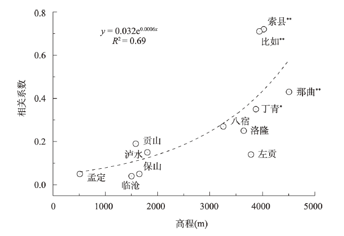
图6
水汽输送和降水序列相关系数及其与高程拟合分析
Fig. 6
Correlation coefficient of water vapor transport and precipitation series and its fitting analysis with elevation
1979—2017年各支水汽输送强度年际变化箱形图表明(图7c),A支水汽输送多年均值达102.6 kg/(m·s),即使输送较弱年份(下四分位数)亦可达81.3 kg/(m·s)。D支水汽输送均值41.3 kg/(m·s),仅有下游地区的40.3%;输送较弱年份仅34.0 kg/(m·s)。可见,夏季流域不同区域的水汽条件差异明显。水汽是形成降水的物质基础和必要条件,流域青藏高原区(C支、D支影响区)较差的水汽条件,使得其降水对水汽输送强度的变化更为敏感。此外,地形也是影响降水形成和分布的重要因子。流域各区域高程和地形起伏度[20]箱形图表明(图7a、7b),平均海拔最高的D支影响区,平均地形起伏度最小,为436 m;而平均海拔最低的A支影响区,地形起伏度为510 m;B支影响区(峡谷区)的地形起伏度最大,达970 m。可见,水汽条件较好的流域中下游地区(A支、B支影响区),具有更大的地形起伏度。已有研究[21]表明,暖湿气流受地形作用,可形成多样的降水模态和分布,降水区在地形迎风坡、背风坡、山顶附近以及地形上、下游都有可能出现。夏季,水热条件较好的流域中下游地区(A支影响区和B支影响区),较大的地形起伏度增加了降水时空分异的不确定性,也会导致其水汽和降水年际变化相关性较弱。
图7
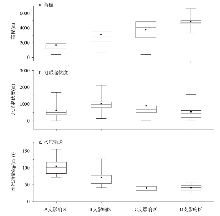
图7
怒江流域不同地区高程、地形起伏度和水汽输送年际变化箱形图
Fig. 7
Boxplot of elevation, terrain relief and water vapor transport in different areas of Nujiang River Basin
4.2 多支水汽输送对降水空间分异的影响
4.2.1 TRMM数据在怒江流域适用性评价
从月、夏季两个时间尺度,计算TRMM降水数据与站点数据的皮尔逊相关系数(r),以及回归直线的斜率(K),以评价TRMM数据在怒江流域适用性。皮尔逊相关系数r越大,表明数据变化的一致性越好;K反映了数据间的偏离程度,K > 1.0,表示TRMM数据偏大,K < 1.0,则TRMM数据偏小;计算结果如表3所示。
表3 TRMM数据在怒江流域适用性评价
Tab. 3
| 站点 | 月 | 夏季 | 站点 | 月 | 夏季 | ||||
|---|---|---|---|---|---|---|---|---|---|
| r | K | r | K | r | K | r | K | ||
| 临沧 | 0.98 | 1.06 | 0.74 | 1.07 | 洛隆 | 0.82 | 1.52 | 0.47 | 1.53 |
| 保山 | 0.94 | 1.1 | 0.87 | 1.25 | 丁青 | 0.96 | 1.04 | 0.89 | 1.05 |
| 贡山 | 0.76 | 0.87 | 0.48 | 1.2 | 比如 | 0.93 | 1.27 | 0.85 | 1.3 |
| 左贡 | 0.83 | 1.35 | 0.76 | 1.34 | 索县 | 0.92 | 1.14 | 0.62 | 1.17 |
| 八宿 | 0.83 | 1.73 | 0.60 | 1.84 | 那曲 | 0.91 | 1.16 | 0.84 | 1.21 |
月降水尺度,地形相对开阔的怒江流域上、下游地区(站点),相关系数均在0.90以上,地形起伏大的中游地区介于0.76~0.82之间(表3)。除贡山站,斜率均大于1.0,表明在怒江流域,TRMM较实测数据普遍偏大,这可能因为山区气象站多建在河谷低处,观测数据难以准确反映降水相对集中的河谷中上部所致。已有研究[22]表明,TRMM数据(0.25°)和实测数据(点降水)的空间尺度差异,是导致数据间差异的重要原因;随着TRMM数据网格内参与分析站点增多,精度评价结果会得到提升。虽TRMM降水数据与实测数据存在一定差异,但TRMM数据的时空连续性以及与实测值具有较高一致性,使其在揭示降水时空分异特征时具有优势[23]。
4.2.2 流域降水空间分异特征
怒江流域多年平均夏季降水栅格数据成果(图8a)表明,降水并非单一的自下游向上游减少。在下游西南部、峡谷区贡山一带、八宿西南部以及上游比如一带有多个区域性多雨带,多雨带邻近流域西侧,且和多支水汽输送具有较好的空间对应关系。
图8
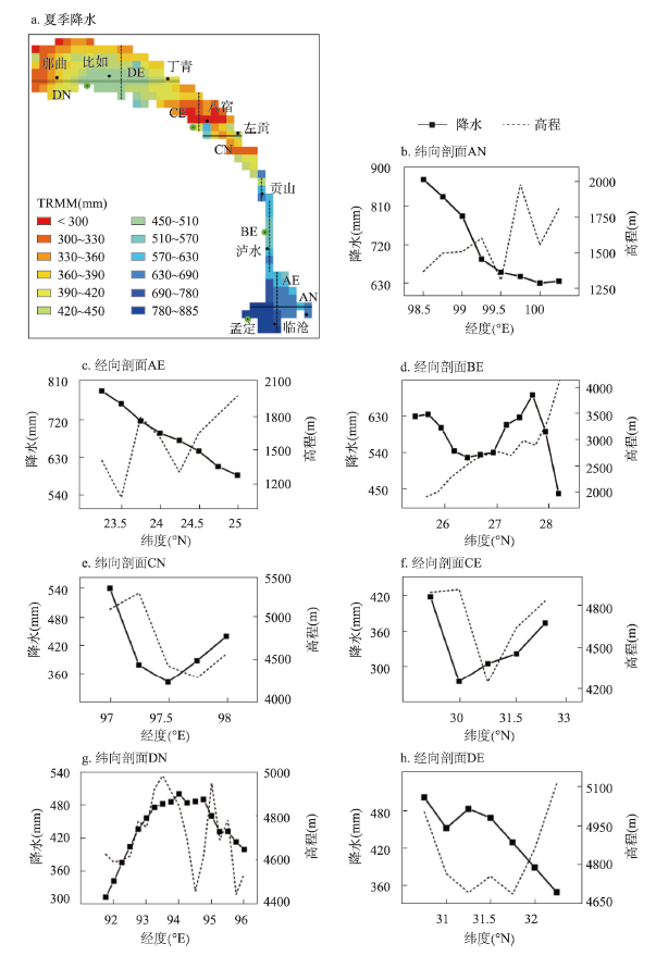
图8
1998—2015年夏季怒江流域多年平均TRMM降水数据
Fig. 8
Multi-year average TRMM precipitation data of the Nujiang River Basin from 1998 to 2015
在各水汽输送影响区,分别取经向(E)、纬向(N)剖面,并绘制沿剖面的降水和高程变化曲线。沿纬向剖面AN(图8b),降水自西向东递减。沿经向剖面AE(图8c),降水自南向北递减。受A支水汽输送影响,该区多雨带位于西南部,降水自西南向东北不断减少。沿经向剖面BE(图8d),降水先随纬度增大而减小,在26.5°N附近达极小值;而后受B支水汽输送影响,降水增多并在27.75°N(贡山一带)达极大值。沿纬向剖面CN(图8e)及经向剖面CE(图8f),降水变化与地形基本一致;受C支水汽输送影响,在八宿西南部迎风坡出现小范围多雨区。沿纬向剖面DN(图8g),在94°E附近为降水高值区,然后向东、西两侧减少;沿经向剖面DE(图8h),降水自南向北不断减少。可见,邻近D支水汽输的比如一带降水较多,而后因水汽消耗降水向四周递减。
进一步对流域多年平均夏季TRMM降水与同期水汽通量、水汽通量散度相关分析(图9),结果表明:降水与水汽通量具有显著正相关关系(通过α = 0.01显著性检验),与水汽通量散度具有显著负相关关系(通过α = 0.01显著性检验)。可见,夏季怒江流域降水空间分异受多支水汽输送影响显著,并形成多个区域性多雨带。
图9
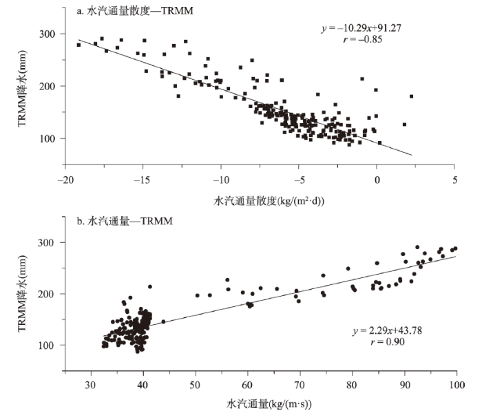
图9
1998—2015年夏季怒江流域多年平均TRMM降水与水汽通量、水汽通量散度相关分析
Fig. 9
Correlation analysis of multi-year average summer TRMM precipitation and water vapor flux, water vapor flux divergence of the Nujiang River Basin from 1998 to 2015
5 结论和讨论
本文基于1979—2017年高分辨率(0.25°)ERA-Interim再分析资料、TRMM 3B43 Version7降水数据以及站点实测数据等多源数据分析了夏季怒江流域水汽输送特征及其对降水影响,主要结论如下:
(1)夏季怒江流域水汽主要自西侧边界输入,在分水岭水汽“通道与阻隔”机制作用下,形成4个区域性水汽输送高值区(多支特征),深刻影响着流域水汽输送的时空格局。4支水汽输送分别位于高黎贡山南部(23.700°N、98.170°E)和北部(26.374°N、98.730°E)、伯舒拉岭北部(30.016°N、96.261°E)以及念青唐古拉山中部(31.278°N、92.973°E),多年平均输送通量分别为102.6 kg/(m·s)、66.3 kg/(m·s)、39.7 kg/(m·s)、41.3 kg/(m·s)。
(2)夏季怒江流域多支水汽输送对降水空间分异影响显著,形成了降水多区域特征。多年平均状况下,流域空间降水数据和水汽通量具有显著正相关关系,和水汽通量散度具有显著负相关关系;受多支水汽输送影响,靠近西侧边界形成多个区域性多雨带,且随水汽消耗降水向四周的展布上不断减少;多支水汽输送对流域夏季降水年际变化的影响,地域分异明显,在中下游的影响较小,在上游青藏高原区的影响较大,尤以那曲—比如—丁青一带的影响最为显著。
本文提出的流域边界(分水岭)水汽输送通量概化和提取方法,在地形复杂、边界不规则的怒江流域具有较好适用性;通过该方法得到流域分水岭上空的水汽通量,可为分析流域水汽输送特征提供数据支撑。本文揭示出夏季怒江流域有多支水汽输送,且形成降水多区域特征,同处青藏高原季风区的雅鲁藏布江、澜沧江等流域是否具有类似现象,有待进一步研究。
参考文献
Water cycle changes: Interpretation of IPCC AR6
IPCC AR6报告解读: 水循环变化
New progress and enlightenment on different types of drought changes from IPCC Sixth Assessment Report
IPCC AR6报告关于不同类型干旱变化研究的新进展与启示
East Asian summer monsoon moisture transport belt and its impact on heavy rainfalls and floods in China
东亚夏季风水汽输送带及其对中国大暴雨与洪涝灾害的影响
The relationship between water vapor transport features of Tibetan Plateau—Monsoon "large triangle" affecting region and drought-flood abnormality of China
青藏高原—季风水汽输送“大三角扇型”影响域特征与中国区域旱涝异常的关系
Effect of energy and water circulation over Tibetan Plateau
青藏高原能量、水分循环影响效应
Climate change will affect the Asian water towers
DOI:10.1126/science.1183188
PMID:20538947
[本文引用: 1]

More than 1.4 billion people depend on water from the Indus, Ganges, Brahmaputra, Yangtze, and Yellow rivers. Upstream snow and ice reserves of these basins, important in sustaining seasonal water availability, are likely to be affected substantially by climate change, but to what extent is yet unclear. Here, we show that meltwater is extremely important in the Indus basin and important for the Brahmaputra basin, but plays only a modest role for the Ganges, Yangtze, and Yellow rivers. A huge difference also exists between basins in the extent to which climate change is predicted to affect water availability and food security. The Brahmaputra and Indus basins are most susceptible to reductions of flow, threatening the food security of an estimated 60 million people.
Whole layer water vapor budget of Yangtze River valley and moisture flux components transform in the key areas of the plateau
长江流域水汽收支与高原水汽输送分量“转换”特征
Features of water tranffer in rainy season and their relations to rainfall anomalies over Tibetan Plateau
西藏高原汛期水汽输送特征与降水异常
Moisture transport features in summer and its rainfall effects over key region in southern margin of Qinghai-Xizang Plateau
DOI:10.7522/j.issn.1000-0534.2014.00034
[本文引用: 1]
Regional water vapor convergence and divergence over the southern margin of the Qinghai-Xizang Plateau (QXP) can be regarded as a good factor for the formation of rainfall climate and extreme weather in the TP and its surroundings. In view of the key region in southern margin of the QXP (the key region for short), summer moisture transport and budget over the key region are analyzed based on the NCEP/NCAR reanalysis data from 1979 to 2010, combined with rainfall station data as well to explore its effects on the rainfall characteristics in the QXP and its surroundings. The main conclusions are summarized as follows. Influenced by the Indian low and the terrain of the QXP, three water vapor transport channels were transformed in the key region from the Bay of Bengal moisture flow, and those led to water vapor divergence over the key region where the southern boundary was the only input one. Meanwhile, different boundaries showed different monthly and interannual variations, especially for the contrary trend of the moisture budget intensity between the western and the eastern boundaries. The budget of input and output boundaries were affected by the activities of the Indian low and the South Asian monsoon, and the output boundaries moisture budget was directly connected with abnormal distribution of rainfall and the development of extreme drought and flood events in the QXP and even the monsoon region surroundings. In addition, the reliability of NCEP/NCAR and JRA-25 reanalysis data in qualitative research over the south margin of the QXP was confirmed by comparison of these tow datasets.
青藏高原南缘关键区夏季水汽输送特征及其与高原降水的关系
DOI:10.7522/j.issn.1000-0534.2014.00034
[本文引用: 1]
青藏高原南缘水汽输送和聚散过程决定着高原及其邻域的降水分布特征, 在提出"青藏高原南缘水汽输送关键区"(简称南缘关键区)概念的基础上, 利用NCEP/NCAR再分析资料分析了1979-2010年南缘关键区夏季水汽输送过程与收支变化, 并根据台站降水量观测资料探讨了南缘关键区各边界水汽收支与高原夏季降水分布的关系。结果表明, 孟加拉湾偏南风水汽流进入南缘关键区后, 在印度热低压与青藏高原大地形制约下, 形成了3条进入高原的水汽输送通道。这使得南缘关键区整体为多年平均水汽辐散区, 除南边界外, 其余均为水汽输出边界。南缘关键区各边界水汽收支年内与年际变化明显, 且东、西边界水汽输出强度变化特征相反。而各边界水汽收支与印度热低压和南海夏季风活动关系密切, 输出边界的水汽支出异常则直接影响着青藏高原乃至周边季风区的降水异常分布以及极端旱涝事件的发生、发展。此外, NCEP/NCAR与JRA-25再分析资料之间的对比验证表明, 这两种再分析资料在青藏高原南缘水汽输送过程的定性研究中是可靠的。
Water vapor transportation and its influences on precipitation in summer over Qinghai-Xizang Plateau and its surroundings
DOI:10.7522/j.issn.1000-0534.2014.00146
[本文引用: 1]
Based on the European Centre for Medium-Range Weather Forecasts (ECMWF) Interim Reanalysis (ERA-Interim hereafter) from 1979 to 2010, the average water vapor transport flux distribution in summer over the Qinghai-Xizang Plateau (QXP hereafter) is calculated and studied. Combined with the high resolution observational data of the daily precipitation over the QXP, four moisture paths influencing the precipitation over the QXP are found, which are defined as the paths of westerly, Arabian Sea, the northern side of Bay of Bengal and South China Sea, respectively. Moreover, the area and function of these paths influencing precipitation process over the QXP have been analyzed and addressed. The results show that the years of both strong (1979, 1984, 1996, 1998, 2002, 2004, 2007) and weak (1994, 2001, 2006) precipitation over the QXP are consistent with the results reflected from path of the northern side of Bay of Bengal. Compared with the rest paths, the influence of the westerly path is weakest, which only has an role in the northwest QXP from Shiquanhe to the south of Tarim Basin; The northern side of Bay of Bengal path has an effect in the central-southeastern QXP;the path of the South China Sea dominates the southeastern and central-south of QXP such as Naqu, Linzhi, Changdu, Yushu and other regions; Arabian Sea path has negative correlations with the rest three paths, especially with the northern side of Bay of Bengal path (<em>R</em>=-0.65, <em>P</em><0.05). Furthermore, Arabian Sea path indirectly modulates the central-southwestern QXP by adjusting the intensity of both the northern side of Bay of Bengal path and South China Sea path. These results suggest that both the water vapor transport path and pattern of precipitation over the QXP is coherently connected.
青藏高原及附近水汽输送对其夏季降水影响的分析
DOI:10.7522/j.issn.1000-0534.2014.00146
[本文引用: 1]
利用欧洲中期天气预报中心(ECMWF)提供的1979-2010年ERA-Interim再分析资料分析了青藏高原(下称高原)及附近夏季水汽输送通量分布情况,并结合基于迄今为止最全面的地面观测数据形成的高分辨率降水资料分析出4条影响夏季高原降水的水汽通道:西风带、阿拉伯海、孟加拉湾北部及南海通道。结果表明:高原夏季降水量高值年(1979、1984、1996、1998、2002、2004、2007年)、低值年(1994、2001、2006年)与孟加拉湾北部通道水汽输送强弱年有较好对应。夏季西风带通道的影响较弱,与其他3条低纬度通道的相关系数较小,是相对独立的水汽通道,主要影响高原西北部从狮泉河至塔里木盆地南侧地区;孟加拉湾北部通道影响高原中南偏东部地区;南海通道则对高原东南部以及中南部那曲、林芝、昌都、玉树等地区有影响;而阿拉伯海水汽通道与其他水汽通道都呈负相关关系,其中与孟加拉湾北部通道相关关系最显著,相关系数达到-0.65,该通道通过调节孟加拉湾北部通道和南海通道的向西水汽输送分量来影响高原中南偏西部地区的夏季降水。
The connection between the precipitation and water vapor transport over Qinghai-Tibetan Plateau in summer based on the multiple datasets
DOI:10.7522/j.issn.1000-0534.2017.00030
[本文引用: 2]
In this study, the monthly precipitation data set at 113 stations during 1979-2014 over the Qinghai-Tibetan Plateau (QTP) provided by the National Meteorological Information Center, had been compared with 4 gridded precipitation data sets (APHRO, CMAP, GPCP, GPCC) and 8 reanalysis data sets (NCEP1, NCEP2, MERRA, ERA_Interim, ERA20c, 20CRv2, JRA55, CFSR).Compared with the observation, it was found that the AHPRO and GPCP can capture the spatial and temporal patterns of the summer precipitation over the QTP during 1979-2007 and 1979-2014, respectively.For the climatology of water vapor, the southern boundary is the main moisture source over the QTP in summer with the dominant channel in the lower layer.Meanwhile, both the western and northern boundaries are also the moisture input over the QTP, with the main channels in the middle layer and the lower layer, respectively.Furthermore, the water vapor output over the QTP is through the eastern boundary by means of its middle layer.Generally, QTP is a moisture sink in summer, and the moisture is convergent over it, to which moisture advection term makes the greatest contribution, while wind divergence term has a diverse effect.In addition, ERA_Interim and NCEP1 showed better ability to delineate these characteristic, however, MERRA was the worst.By comparing multiple datasets, it was shown that MERRA and ERA_Interim can better depict the water vapor transport condition over the local QTP and peripheral area, respectively.Exploring relationship between the precipitation variability over the southeastern QTP and the atmospheric circulation, we picked out the high and low value years according to precipitation index.By conducting the synthesis analysis on them, it was shown that the moisture from the western boundary was the most sensitive to climate change and the decrease of net income in dry years was greater than the increase of net income in wet years, and ERA_Interim and MERRA can represent the water vapor transport condition at different boundary and levels in dry years and wet years better, respectively.Conducting the synthesis analysis on the integrated water vapor transport, it was revealed that there is a zonally orientated anticyclone anomaly across the Indian subcontinent and the Bay of Bengal, and the strong westwards water vapor transport at its northern edge attributes to the excessive precipitation over the southeastern QTP.
基于多源数据的青藏高原夏季降水与水汽输送的联系
DOI:10.7522/j.issn.1000-0534.2017.00030
[本文引用: 2]
利用国家气象信息中心提供的1979-2014年青藏高原(下称高原)地区(26°N-42°N,75°E-105°E)113个站点的逐月降水资料作为基准降水资料,与另外4套格点降水资料(APHRO、CMAP、GPCP、GPCC)和8套再分析的降水资料(NCEP1、NCEP2、MERRA、ERA_Interim、ERA20c、20CRv2、JRA55、CFSR)作对比,可得12套再分析资料中,APHRO能够最好地刻画出高原1979-2007年夏季降水的时空分布形态。GPCP次之,能够较好地刻画其1979-2014年的特征。就气候态而言,水汽主要由南边界输入高原,输入大值区是下层;另外水汽同样从西边界和北边界输入高原,主要的输入层分别是中层和下层;而水汽主要是从东边界中层输出。多套资料比较可知,ERA_Interim和MERRA分别能较好地刻画高原本地和其周围地区夏季水汽输送情况。研究高原东南部降水的年际变化和环流的关系,发现在印度半岛和孟加拉湾处有一异常的纬向反气旋,其北边缘加强的水汽输送导致了高原东南部降水的异常增多。
Study on the moisture joining area of Asia and Indian-Pacific Ocean and its spatial variation in the Northern Hemisphere
北半球夏季印度洋和太平洋水汽交汇区及其空间分异规律研究
The climate characteristics and changing trends over the Nujiang River Basin in Tibet from 1971 to 2008
DOI:10.11821/xb200905007
[本文引用: 1]
This paper studies the changing trend of annual and seasonal mean temperature, maximum temperature, minimum temperature, precipitation and sunshine duration etc. by using the observational data of 9 meteorological stations over the Nujiang River Basin in Tibet from 1971 to 2008. It also analyzes the variation trend of meteorological elements by climatic linear trend methods, and discusses the correlation between the linear trend of elements and latitude, altitude and longitude. The results show that the annual mean temperature has increased over the Nujiang River Basin with a rate of 0.26 oC/10a during the past 40 years, which is lower than that in Northeast China and Northwest China, and is higher than that in the Huaihe River basin and South China, and similar to that over the Qinghai-Xizang Plateau. The trends of mean maximum and minimum temperatures are increasing, the trend of diurnal temperature range is significantly decreasing at a rate of (-0. 13~-0.57) oC/10a. The annual precipitation increases significantly and the linear increasing rate is 21.0mm/10a, while that in all seasons increases. The annual sunshine duration decreases over the Nujiang River Basin with a rate of -31.7 h/10a, and the maximum decrease is in summer, and the rate of decrease is greater than that in the Huanghe River basin and eastern margin of the Qinghai-Xizang Plateau. In addition, the variation of maximum frozen soil depth shows a significant declining trend over the upper reaches of the Nujiang River Basin in Tibet, resulting from the increasing soil temperature, especially in Amdo. Correlation analysis demonstrates that sunshine duration is significantly negative with precipitation (all seasons) and surface vapor pressure (in summer and autumn). Results indicate that the principal causes for the decrease of sunshine duration are the significant increase of surface vapor pressure and precipitation in most parts of the Nujiang River Basin. The correlation between total cloud amount and diurnal temperature range is negative significantly, and is positive evidently with precipitation in summer, hence the relative humidity is not the main affecting factor with the decrease of total cloud amount. The amplification of annual temperature and precipitation became greater with the increase of altitude and latitude. The linear trend of sunshine duration is positively related with longitude, and the decreasing amplitude of sunshine duration in summer and winter decreases with increasing longitude.
近40年西藏怒江河谷盆地的气候特征及变化趋势
Regional climate and its change in the Nujiang River Basin
DOI:10.11821/xb201205005
[本文引用: 1]
Long time series of monthly air temperature and precipitation data, which were recorded at 16 meteorological observation stations in the Nujiang River basin and its adjacent areas, were employed to analyze spatial distributions and changes of these meteorological elements in this basin during the past decades. In this research, TFPW-MK (Trend-free Pre-whitening Mann-Kendall) test and BFAST (Breaks For Additive Seasonal and Trend) were used to determine trends in climate data and to detect abrupt changes within the trend and seasonal components, respectively. The results show that air temperature and precipitation increased southward along the Nujiang River and heavily negatively correlated with altitude. The regional difference in PCD was obvious and higher PCD values, more than 60%, were observed in the Nujiang River basin in Tibet Autonomous Region. Precipitation-concentration time (PCT) in the study area (except for Gongshan) mainly from late July to late August. Generally speaking, the Nujiang River basin has become warmer in the past decades. The annual mean air temperature increases at a rate of 0.36 ℃/10a.
怒江流域气候特征及其变化趋势
DOI:10.11821/xb201205005
[本文引用: 1]
利用怒江流域及其毗邻地区16 个气象台站长时序逐月气温和降水量数据,运用TFPW-MK (Trend-free Pre-whitening Mann-Kendall) 检验和重复迭代变化诊断等方法,分析了近几十年来怒江流域气候要素空间格局和变化特征。结果表明:(1) 怒江流域气温(年平均、年最高和年最低) 和年降水量由北向南总体呈递增,并与海拔相关性极为显著(α=0.01),且气候要素值随海拔升高而降低;(2) 降水集中度地域差异明显,西藏境内降水集中度多达60%以上,全流域降水集中期(除贡山站外) 多介于7 月下旬至8 月下旬;(3) 流域升温趋势显著,其年平均、年最高和年最低气温变化趋势多与纬度和海拔呈显著相关,其中年平均气温增幅为0.36 ℃10a;(4) 部分站点气温变化存在突变点,且其多出现于暖冬频发的20 世纪80 年代以后;(5) 年降水量总体有所增多,但变化趋势多不显著,无明显变点。
Spatial-temporal validation of TRMM 3B42V7 precipitation products and analysis of precipitation characteristics in the upper reaches of Nujiang River
DOI:10.7522/j.issn.1000-0534.2016.00071
[本文引用: 1]
The Nujiang river is a typical area of lacking data with complicated terrain and climate characteristics. TRMM (Tropical Rainfall Measuring Mission) precipitation data can effectively describe the spatial distribution characteristics of regional precipitation, and it has great reference value to the area of lacking information. We use TRMM 3B42V7 data and 18 weather stations data to explore the spatial and temporal distribution characteristics of precipitation and analyze the accuracy of TRMM 3B42V7 data in the upper reaches of Nujiang river. The correlation coefficient method and spatial analysis method are used to solve the problem. By analyzing the correlation coefficient, it shows that the best correlation coefficient between TRMM 3B42V7 data and the site observation data occurs at monthly scale (<i>R</i>>0. 9), second is yearly scale (<i>R</i>>0. 5), the worst is daily scale (<i>R</i> < 0. 5). The two sets of data have strong correlation under monthly scale when it comes to areal precipitation (<i>R</i>≈0. 98). Time series also fit well though TRMM 3B42V7 data is slightly larger than the site observation data in the month of abundant precipitation. Spatial-temporal comparative analysis indicates that precipitation spatial distribution has good consistency of these two group data at different time scales though the local distribution characteristics are different. There is an underestimation tendency of TRMM 3B42V7 data in the northwest of the basin, and overestimation tendency in the southeast. Precipitation in most other area has little difference between TRMM 3B42V7 data and the site observation data. TRMM 3B42V7 data is also used to analyze the seasonal proportion of precipitation in the basin and it is found that seasonal patterns of precipitation in study area vary greatly. Precipitation in summer (from June to August) account for a large proportion of total annual precipitation. The ratio of precipitation in summer is 42%~72%, while the total ratios of spring (from March to May), autumn (from September to November) and winter (from December to February) to annual precipitation are 28%~58%.
怒江上游TRMM 3B42V7降水产品资料时空验证及降水特征分析
DOI:10.7522/j.issn.1000-0534.2016.00071
[本文引用: 1]
利用1998-2013年热带测雨卫星TRMM 3B42V7降水数据产品和18个气象站点观测数据对怒江上游进行了降雨时空分布特征的对比分析,研究了TRMM 3B42V7数据产品在该区域的精度。结果显示:研究区内TRMM 3B42V7数据和站点数据相关性月尺度最强(R>0.9),年尺度次之(R>0.5),日尺度较差(R < 0.5);流域面雨量两组数据在月尺度上有极强的相关性(R≈0.98),时间序列拟合较好,但在降水量大的月份TRMM 3B42V7数据较站点观测数据略偏大;不同时间尺度下两组数据的空间分布特征总体具有较好的一致性,局部分布特征有差异;流域西北和东南局部区域TRMM降水分别有低估和高估趋势,其他大部区域相当。利用TRMM 3B42V7数据对流域降水进行季节占比分析,结果显示,流域降水季节分配不均匀,夏季(6-8月)降水占全年降水总量的比例较大,高达42%~72%;其他春(3-5月)、秋(9-11月)、冬(12月至次年2月)三季节降水整体较少,总占比为28%~58%。
Preliminary studies on both the mountain blocking and moisture passage effects
There is a cross place between the Himalayas with a west-east direction and Hengduan Mountains with a north-south directions in which the Yarlung Zangbo River,Nu River and Lang Chang River are moving through it on the southeast part of the Tibet Plateau.As there is a special topography conditions,both of the mountain blocking and moisture passage effects on the distribution of precipitation,climatic and natural zones are obvious.The mountain blocking effects resist the warm and humid stream to make the great difference of the precipitation,climatic and natural zones between the two sides of the mountains.Meanwhile,both of the mountain blocking and moisture passage effects form the special distribution of precipitation,climatic and natural zones in this region,which make a great natural contribution for mankind of forming an ideal heaven.
山地屏障与水汽通道综合作用初探: 兼谈大香格里拉自然成因
在我国藏东南地区,东西走向的喜马拉雅山脉与南北走向的横断山脉相交,雅鲁藏布江、怒江和澜沧江穿流于其间,这种特殊的地形条件具有的屏障和水汽通道综合作用对降水分布和气候自然带分布带来特殊的影响。屏障作用阻挡了西南季风的暖湿气流,带来山脉两侧(南北向或东西向)降水和气候自然带分布的巨大差异;同时,在该区,山地屏障作用与水汽通道作用同时存在,两者综合作用形成了特殊的降水和气候自然带分布,为形成人类的理想天堂-大香格里拉地区做出了自然贡献。
Climate characteristics of water vapor resource over low latitude plateau area
低纬高原地区水汽资源的气候变化特征
Study on the optimal scale for calculation the relief amplitude in China based on DEM
基于DEM的中国地形起伏度适宜计算尺度研究
An idealized three-dimensional numerical study of the topographic precipitation under air flow of large CAPE and conditionally unstable stratification
大对流有效位能和条件不稳定下地形降水的三维理想数值研究
A comparison of the precipitation from rain gauge observations with from TRMM PR measurements in the southern China
中国南方地基雨量计观测与星载测雨雷达探测降水的比较分析
