

1 引言
20世纪80年代以来,中国城镇化和工业化的发展,促使农村劳动力大量转移到非农产业,农业劳动力成本不断上升,山区耕地面临严重的边际化现象[1⇓-3]。农户通过调整作物种植结构、改变土地利用集约度、提高机械化程度等方式来应对边际化现象,导致耕地“非农化”“非粮化”“双改单”现象愈发明显[4-5]。耕地撂荒是土地边际化的极端表现形式,农业生产环境较差的山区耕地最易被挤出农业生产成为边际外土地[6]。农村劳动力的非农转移是耕地撂荒的主要驱动力[7⇓-9],地块、农户、村庄在劳动力特征[10⇓-12]、耕地资源禀赋[13⇓-15]、农业基础设施[8,15]等方面的不同造成耕地撂荒程度以及空间分布上的差异。近年来,国内耕地撂荒现象被广泛调研和报道,研究显示2013年中国耕地闲置率为5.72%[16],2015—2016年全国山区县耕地撂荒率为14.32%[17],2019年全国耕地撂荒率约20%[18]。耕地撂荒程度区域差异较大,中西部的耕地撂荒程度总体上高于东部地区[16],南方省份高于北方省份[19]。从现有研究来看,中国耕地撂荒呈现出撂荒程度不断加深与撂荒范围不断扩大的趋势[16-17,20]。
梯田是山坡地上沿等高线方向修筑的条状阶台式或波浪式断面的田地[21],是人们长期改造自然、适应自然的结果,是山区质量较高的耕地。梯田广泛分布在世界各地,地中海沿岸、非洲南部、中美洲、东亚、东南亚等地均是梯田分布的集中区域。中国是世界上最早修筑梯田的国家之一,也是梯田分布最广的国家之一。中国修建梯田的历史可以追溯到秦汉时期,1949年中华人民共和国成立之后的“农业学大寨”运动使梯田得到了大规模的发展[21],近年来政府为治理山区水土流失也修建了大量梯田[22]。根据第二次全国土地调查,中国梯田规模为18610千hm2(约2.8亿亩),占耕地总量的13.7%。梯田具有减少径流、控制土壤侵蚀,提高土壤肥力,抵御自然灾害等功能[23],是山区重要的耕地资源。梯田可有效提高粮食产量[24],在历史时期为满足人口增长对粮食产量的需求发挥了重要作用;在生态建设方面,当前坡改梯工程仍是中国丘陵山区治理水土流失的重要措施[25],中国梯田对减少径流和泥沙的平均效益分别为48.9%和53.0%[26]。然而,随着山区边际化进程的加剧,作为山区珍贵的耕地资源——梯田也正经历坡耕地同样的边际化历程,耕地撂荒现象从质量较差的坡耕地延展至较为优质的梯田。通过新闻报道和文献资料发现,全国很多著名的梯田景区都面临严重的撂荒现象,例如2017年湖南省新化县紫鹊界景区梯田撂荒率为20%[27],2014年江西省崇义县思顺乡客家梯田撂荒率甚至达到了39%[28]。
大规模梯田撂荒将会引发一系列社会与生态效应。作为山区的优质耕地资源,梯田撂荒以及农业种植结构调整出现的“非粮化”[29]、粗放化[30]等现象,在一定程度上构成对粮食安全的威胁。同时梯田撂荒会引发山区植物群落[31-32]、土壤侵蚀[33-34]、碳储存以及景观和生物多样性变化[35⇓-37]等一系列复杂的生态演变过程。近年来随着耕地撂荒程度的不断加重,耕地撂荒问题不再局限于学术界调查研究,政府部门也逐渐重视,中央及各级地方政府陆续出台相关的政策指导文件,加强对耕地撂荒问题的整治。2021年1月农业农村部印发了《农业农村部关于统筹利用撂荒地促进农业生产发展的指导意见》(农规发〔2021〕1号)[38],指出要充分认识到统筹利用撂荒耕地的重要性,采取各种措施促进撂荒地的重新利用。
2 数据获取和研究方法
2.1 研究对象和研究区范围
(1)研究对象
根据种植方式不同,梯田可以分为水作梯田和旱作梯田;根据田坎类型的不同,梯田可以分为土坎梯田、石坎梯田、土石混合梯田等;根据结构和外观不同,梯田可分为波浪式梯田、反坡梯田、水平梯田等[21,41]。本文的梯田指土地利用现状分类中耕地大类下的细分,定义为坡度2°以上山坡地上沿等高线方向修筑的条状阶台式或波浪式断面的田地,不包括种植果、茶等阶梯状园地;从结构上看多为水平梯田和反坡梯田;在种植方式上,南方多为种植水稻的水田,北方多为种植旱作作物的旱作梯田。参考国内外相关研究[42⇓-44],本文撂荒梯田是指连续2年以上未种植任何作物任其荒芜的梯田,因国家的退耕还林工程而转为种植业以外其他用途的梯田和因休耕政策导致的闲置梯田不在本文研究范围内。
(2)调查区范围
本文问卷调查范围限于中国丘陵山区耕地中有梯田分布的县(县级市、区),根据第二次全国土地调查数据,中国梯田分布在27个省份的1708个县(县级市、区)之中。需要说明的是,黑龙江省、天津市、上海市、江苏省等4省(市)无明显的梯田分布,香港特别行政区、澳门特别行政区、台湾省等区域数据暂缺(图1)。
图1
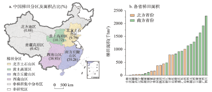
图1
中国梯田分区以及各省份梯田面积
Fig. 1
Regions of terraced fields and provincial areas of terraced fields
为揭示梯田撂荒程度的空间分异特征,根据第二次全国土地调查反映的梯田分布状况,参考全国水土保持区划、九大农业分区以及六大行政分区等,本文以县级行政区为基础单元将中国划分为6个梯田分布区,其中北方土石山区、黄土高原区、南方丘陵山区和西南山区是梯田集中分布的区域,梯田总面积占比为98.70%;北方地区和青藏高原区梯田面积较少,实地收集的样本数量也较少,因此该两区未纳入分析范畴(图1)。
2.2 调查方案
(1)调查样本量的确定
式中:S表示调查所需的样本量;X 2表示所需置信度水平下1个自由度的卡方值(取值3.841);N表示总体规模;P表示总体的百分比(取其样本变异程度最大时的值0.5);d表示准确度(取值0.05)。
全国有梯田分布的县数量(N)为1708个县,根据公式(1)确定样本量(S)为314个县,抽取比例为18%。本文调查范围广,区域异质性程度高,故采用分层抽样和随机抽样相结合的方式进行问卷调查,以保证样本分布的均衡性,提高抽样效率以及抽样调查结果的可靠性。根据分层抽样的要求,在省级层面依据每个省级行政单元梯田面积占比和梯田县数量占比的平均数作为每个省份要抽取的梯田县的比例,在每个选定的县中随机抽取1~2个行政村,每个行政村随机调查4~6个农户。
(2)实地调查情况
实地调查采取大学生寒暑假返乡调查和课题组实地调查相结合的方式进行。由于中国梯田范围分布广,每个地区要调查的样本又不宜过多,通过招募大学生寒暑假返乡进行调查,可以提高调查效率、节省调查成本。同时,大学生熟悉自己行政村的基本情况,沟通顺畅,更易获得准确的调查结果;为提高调查的可靠性,调查大学生所学专业规定在地理学、农学、社会学等学科内,并进行了问卷调查培训与实时指导。
大学生返乡调查共进行了3轮,时间分别为2020年1—3月、2020年6—9月和2021年1—3月。由于梯田区域均分布在交通不便的山区,而且问卷调查工作受到新冠疫情的影响,返乡调查不足以完成设计方案中的样本数量。因此,课题组针对一些样本不足的区域,在湖北省、湖南省、四川省、贵州省、云南省、广西壮族自治区、广东省、甘肃省、陕西省、安徽省等省份进行了补充调查,实地补充调查一共进行了3次,调查时间分别为2020年11—12月、2021年3月和2021年4月。
调查员在每个行政村收集1份村问卷和4~6份农户问卷,并撰写一份调查报告。行政村问卷的调查对象为知情村干部,主要为村主任、文书等,调查内容主要为村庄的劳动力情况、耕地面积与质量、土地流转、撂荒情况、作物种植情况等;农户问卷的调查对象是行政村内部经营耕地的农户,调查内容主要为家庭耕地面积、耕地利用情况、家庭成员基本信息以及家庭收入情况等。行政村问卷和农户问卷调查的均是上一年的情况,即问卷调查时点为2019年和2020年。
(3)问卷收集情况
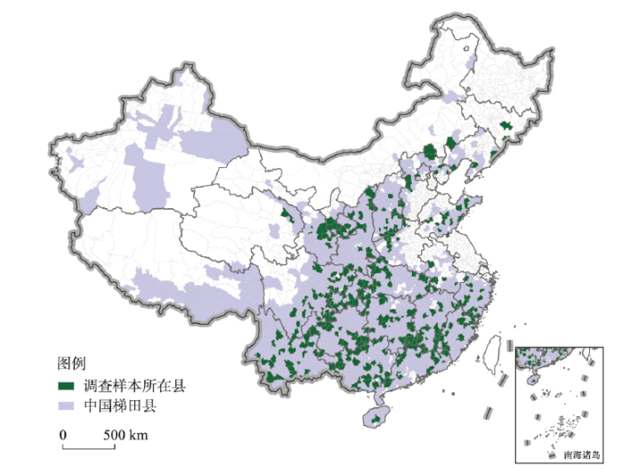
大学生返乡调查和课题组实地调查共覆盖了全国346个县,占全国梯田县总数的20%,共收集到行政村问卷598份和农户问卷2960份。西藏自治区和新疆维吾尔自治区未收集到调查问卷。
问卷修正和清理的流程如下:① 依据调查报告中提供的信息、基本的常识和逻 辑、数据的一致性等检查和判读问卷中可能出现的错误值和异常值;② 与调查员进行沟通,对有错误或者遗漏的问题通过电话回访的方式进行修正;③ 针对问题不清的部分 问卷,课题组进行了电话回访;④ 对不符合调查要求、有明显错误且无法进行修正的 问卷进行剔除;⑤ 个别省份样本过多,根据抽样调查的要求,随机删除了部分样本。最终获取有效行政村问卷560份,农户问卷2204份。行政村问卷覆盖了329个县(图2),占全国梯田县总量的19%,超过314个县的样本容量阈值。大学生完成行政村问卷 399份,占比71%,课题组补充调查161份,占比29%。2020年完成行政村问卷490份,占比88%,2021年完成70份,占比为12%。农户问卷的构成情况与行政村问卷大致相同。
图2
2.3 研究方法
(1)梯田撂荒率计算方法
考虑农户外迁可能会造成农户调查样本有偏,本文的梯田撂荒率主要基于行政村问卷结果进行测算。由于各个县行政村问卷数量不一致,根据分层抽样的要求[17],首先对各个县的调研数据进行处理,再计算不同尺度的撂荒率。具体计算公式如下:
式中:VBAij为调研县i中行政村j的梯田撂荒面积;CBAi为调研县i的平均梯田撂荒面积,即县内n个行政村梯田撂荒面积平均值;VAij为调研县i中行政村j的梯田总面积;CAi为调研县i的平均梯田面积,即县内n个行政村梯田面积平均值;R为梯田撂荒率,即m个调研县的平均梯田撂荒面积的总和与m个调研县平均梯田面积的总和的比值。
(2)方差分析法
本文采用方差分析法对梯田撂荒的空间分异程度进行验证。方差分析考察两个及两个以上因变量均数上的差异是否具有统计学意义,又称F检验。方差分析是基于变异分解的思想,整个样本的变异可以分为随机变异和处理因素导致的变异,可证明处理因素导致的变异是否存在[48]。一般来说,方差分析需要满足各处理水平下样本的随机性和独立性、组间方差齐性以及因变量服从正态分布等条件。进行单因素方差分析前要进行方差齐性检验,当样本未通过方差齐性检验时,使用“韦尔奇”检验优于F检验。当处理因素多于两组时,可进一步进行事后比较,在不满足方差齐性的条件下,使用“塔姆黑尼”检验作为多重比较的结果。本文使用SPSS 26.0进行单因素方差分析。
3 结果分析
3.1 梯田撂荒时间演变特征
根据244份有撂荒时间记录的行政村调查问卷的分析可以看出,中国梯田撂荒现象从20世纪80年代发展至今,2000年以后梯田撂荒村庄呈现明显增多的趋势(图3)。从4个梯田分区看,2000年之前发生梯田撂荒的村庄主要分布在南方丘陵山区。2000年以后黄土高原区、南方丘陵山区和西南山区发生梯田撂荒现象的村庄数量均呈明显增加的趋势,尤其是2010—2015年间梯田撂荒村庄数明显增多。北方土石山区发生梯田撂荒的村庄数量较少,且时间趋势不明显。
图3
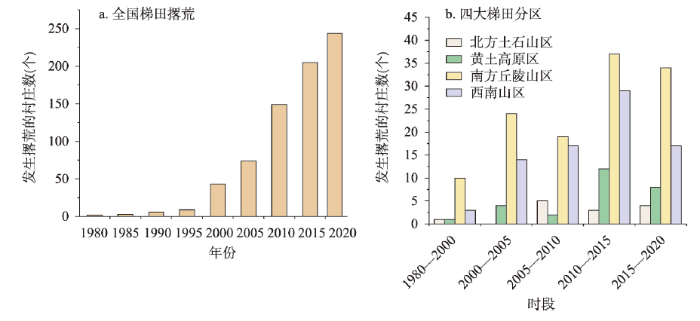
图3
中国梯田撂荒发生的时间格局
Fig. 3
Temporal changes of surveyed villages with terrace abandonment
3.2 撂荒村数量
中国发生梯田撂荒的村庄占调查村庄总数的54%,南方省份发生撂荒的比例为65%,北方省份比例为28%。从4个梯田分区看,南方丘陵山区是村庄发生梯田撂荒现象最严重的区域,梯田撂荒村庄数量占比为72%,西南山区为55%,黄土高原区为38%,北方土石山区为20%。调查省份中,吉林省、辽宁省、内蒙古自治区、青海省和海南省所调查的村庄未发现梯田撂荒,其他省份均发生了不同程度的梯田撂荒现象,其中广东、福建、贵州、浙江、湖南、安徽、重庆、湖北等省份梯田撂荒村庄数量占比超过了60%;江西、宁夏、四川、广西、云南、陕西、山西、甘肃、河北等省份占比在20%~60%之间;河南、山东等省份占比在20%以下(图4)。
图4
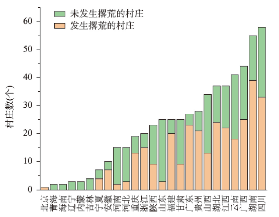
图4
调查村庄出现撂荒的数量
Fig. 4
The number of surveyed villages with terrace abandonment
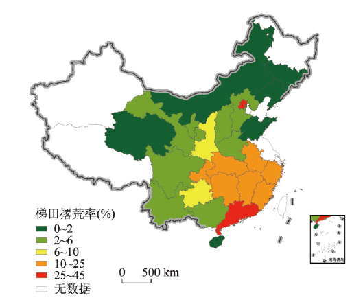
3.3 梯田撂荒面积
中国梯田面积撂荒率为9.79%,南方撂荒程度明显高于北方。从四大梯田分区来看,4个梯田分区之间撂荒程度差异明显。撂荒最严重的是南方丘陵山区,梯田撂荒率为20.96%,其后依次是西南山区7.16%,黄土高原区4.36%,北方土石山区3.04%。单因素方差分析结果表明,南北方以及四个梯田分区撂荒程度在统计学上存在显著差异(“韦尔奇”检验P < 0.05)。“塔姆黑尼”多重比较结果显示,北方土石山区撂荒程度和南方丘陵山区、西南山区之间存在显著差异(P < 0.05);黄土高原区撂荒程度和南方丘陵山区之间存在显著差异(P < 0.05);南方丘陵山区的撂荒程度与北方土石山区、黄土高原区、西南山区之间均通过了显著性检验(P < 0.05);黄土高原区撂荒程度和北方土石山区、西南山区之间没有通过显著性检验。
与梯田区特征相同,各省撂荒程度也存在明显差异,其中长江中下游区省区撂荒较为严重、集中。具体来看,梯田撂荒最严重的是广东省和北京市,撂荒率分别为44.67%和30%;福建省、江西省、浙江省、重庆市、安徽省、湖北省、湖南省等长江中下游的省份,撂荒率在10%~25%之间;贵州省和陕西省的撂荒率在6%~10%之间;广西壮族自治区、山西省、宁夏回族自治区、四川省、云南省、河北省、甘肃省、河南省的梯田撂荒率在2%~6%之间;山东省、海南省、青海省、吉林省、辽宁省、内蒙古自治区的梯田撂荒率在2%以下(图5)。
图5
4 讨论
4.1 调查结果的评估
由于前人研究多聚焦于耕地撂荒率,为了增强与其他调研数据的可比性,本文也计算了调查区的耕地撂荒率,计算方法与梯田撂荒率计算方法相同。从结果来看,中国梯田区耕地撂荒率为9.01%,相比金芳芳等利用中国家庭收入调查数据测算的2013年全国耕地撂荒率5.72%偏高[16],可能是由于金芳芳等研究范围包含了撂荒率较低的平原地区与耕地撂荒程度随着时间的推移有加重趋势的原因;相比李升发等采取抽样调查的方式测算的2014—2015年全国山区县的耕地撂荒率14.32%偏低[17],可能是由于此次调查的地域范围更加广泛,不仅限于山区县,也包含地势相对平缓的丘陵地区。从耕地撂荒发展的时间上看,已有研究表明2000年后中国耕地撂荒现象开始增多[17,20],2005年可能是耕地撂荒的时间突增点[17]。本文中梯田撂荒现象同样从2000年左右开始凸显,2010年左右明显增多,梯田与坡耕地相比撂荒发展时间相对滞后,符合耕地边际化发展特点[49]。从耕地撂荒程度的区域差异上看,已有研究表明南方和西部撂荒较为严重[16-17],其中长江流域、云贵高原等是耕地撂荒较为严重的区域[17-18,20];不同的是,本文中梯田撂荒较为严重的区域更为集中,主要分布在长江中下游区域,除了个别省份,西南和北方区域撂荒程度都较小。
目前梯田撂荒率为9.79%,撂荒规模已经不容忽视。根据第二次全国土地调查,中国现有梯田总量2.8亿亩(1亩≈ 666.7 m2),按此推算全国梯田撂荒面积已达到2800万亩左右,接近浙江省全省的耕地面积,或“十三五”(2016—2020年)期间全国坡改梯规划规模(491万亩)的6倍[22],大范围的梯田撂荒无疑是对过去人力与资本投入的浪费,减少了山区农户的生计资产,同时造成粮食产量损失以及生态风险增加。另外,本次调查过程中,新疆维吾尔自治区和西藏自治区没有找到合适的调查地点和调查员,未收集到这两个省区的问卷。但是从第二次全国土地调查数据来看,新疆维吾尔自治区与西藏自治区梯田面积在全国梯田总面积中的比重分别为0.12%与0.21%,相对较小,忽略两者对全国梯田撂荒率的计算结果影响不大。
4.2 梯田撂荒原因
村干部不仅是村庄的实际管理者往往也是耕地的经营者,对梯田撂荒的原因有较好的认知能力。根据村干部认知性的回答,本文对梯田的撂荒原因进行了归纳总结(图6a)。按照认可程度依次为:① 外出务工劳动力人数较多;② 梯田耕作机械化程度低;③ 梯田灌溉条件差;④ 耕作交通条件差;⑤ 野生动物破坏;⑥ 梯田肥力较差。从各个梯田分区来看,劳动力的缺乏是各个区域的首要因素,其次是机械化程度;差别是,野生动物破坏对南方丘陵山区的影响较为明显;其他因素在各个区域之间的差异性相对较小。
图6
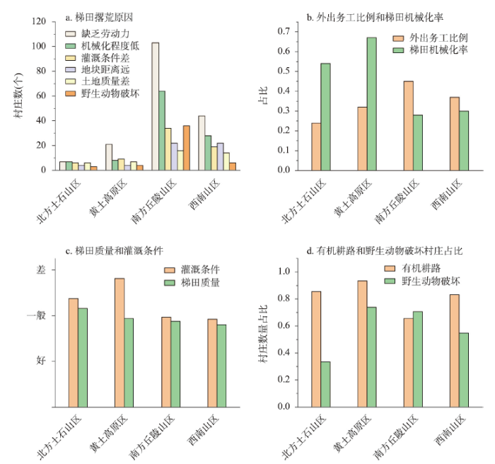
详细来看(图6b~6d),四大梯田分区中,南方丘陵山区外出务工比例最高,其次是西南山区,然后是黄土高原区和北方土石山区。梯田机械化程度最高的是黄土高原区,其次是北方土石山区,南方丘陵山区和西南山区梯田机械化率较为接近;在灌溉条件方面,西南山区、南方丘陵山区的灌溉条件较好,北方土石山区、黄土高原区较差;在梯田质量方面,北方土石山区相对较差,其他区相差不大;机耕条件中,有机耕路的村庄占比最高的是黄土高原区,西南山区和北方土石山区相差不大,占比最低的是南方丘陵山区;在野生动物破坏方面,黄土高原区和南方丘陵山区有野生动物破坏作物的村庄比例较高,其次是西南山区,北方土石山区比例较低。可以看出,外出务工比例较高以及机械化程度较低的地区,梯田撂荒相对越严重;耕作交通条件较好的区域撂荒相对较少;野生动物破坏方面,除了黄土高原区以外,其他区域均符合野生动物破坏越严重梯田撂荒率越高的规律。灌溉条件、梯田质量的差异与撂荒区域差异之间没有一致的趋势。由此可知,梯田撂荒的原因与山区耕地边际化机理是相吻合的,即由于务农机会成本上涨,农业劳动力成本上升,导致无法机械化的梯田耕作成本增加,利润不断下降,从而引发撂荒。在农业劳动力不断析出的过程中,如何进一步促进机械对劳动力的替代以及改善农业生产环境成为减缓梯田撂荒的关键。
5 结论与政策启示
5.1 主要结论
本文通过大学生返乡调查和课题组实地调查相结合的方式,对中国1708个梯田县进行了抽样调查,共获取有效行政村问卷560份,农户问卷2204份,调查覆盖了25个省(市)和329个县。这是全国首次采用大样本实地调查方式针对梯田撂荒主题的研究,主要结论如下:
(1)目前中国梯田撂荒现象严重,分布广泛,南方撂荒程度明显高于北方。从面积上看,全国梯田撂荒率为9.79%;从村庄数量上看,全国梯田撂荒村庄占比为54%。分区域来看,南方丘陵山区梯田撂荒率为20.96%,撂荒程度最高,尤以长江中下游区域最为集中。从省级层面看,梯田撂荒率超过10%的有9个省份,主要为南方省份,撂荒程度从高至低依次为广东、北京、福建、江西、浙江、重庆、安徽、湖北和湖南。
(2)梯田撂荒现象从2000年左右开始显现,2010年后明显增加。梯田撂荒现象始于20世纪80年代,2000年前后该现象开始凸显,2010—2015是梯田撂荒现象增加最明显的时间段。2000年之前梯田撂荒现象主要发生在南方丘陵山区,2000年以后黄土高原区、南方丘陵山区和西南山区梯田撂荒现象明显增多,北方土石山区梯田撂荒现象较少,撂荒发展趋势也不明显。
(3)梯田撂荒的主要原因为外出务工劳动力人数较多与梯田耕作机械化程度较低。根据梯田行政村村干部的认知总结,外出务工劳动力人数较多是影响梯田撂荒的首要因素,这与南方丘陵山区外出务工劳动力比例最高与撂荒程度最为严重的客观统计结果相吻合。另外,机械化程度和与之有密切关联的道路交通条件也对梯田撂荒有重要影响。
5.2 政策启示
经实地调查发现,目前地方政府为遏制梯田撂荒主要采取以下几种手段:① 制订强制性措施防止耕地撂荒,如有些地方规定“撂荒两年以上耕地会被村集体收回”;② 由地方政府牵头进行梯田流转,发展特色产业或旅游业;③ 采用财政补贴的方式对特色产业或梯田景区进行补贴。但从实际情况来看,以上措施由于缺乏有效性和持续性,执行成本高,总体上实施效果不佳。另外,尽管近年来国家对耕地撂荒逐步重视,陆续出台了相关的政策文件,但缺乏梯田针对性政策。
如何有效遏制梯田撂荒,保障国家粮食安全和山区农户生计稳定,需加强梯田撂荒分类分区治理,依据本文的研究结论,提出以下应对措施:① 针对坡度较大,耕作距离较远、质量较差的梯田,可有序实施“退耕还林”;对于靠近村庄、质量较好的梯田,结合当地具体条件,适当发展林果业等经济作物,并鼓励流转以促进梯田的有效利用。② 加强农业基础设施建设,适当推进梯田宜机化改造。对于黄土高原区等坡度较缓、地块较大的梯田分布区,可通过田块整治、道路修建等方式适当推动中型乃至大型农机的发展;对于南方丘陵山区等坡度较大、田块较小的梯田分布区,可适当推动小型农机的发展。③ 在加强农机购置补贴的基础上,可重点推动农业机械的社会化服务,减缓农业劳动力的缺乏以及降低农业生产成本。
参考文献
Diagnosis on the marginalisation of arable land use in China
DOI:10.11821/yj2006050015
[本文引用: 1]

The history of the land use of many developed countries shows that the courses of industrialization of economy and urbanization of population are usually accompanied by marginalization of agricultural land use.China is now in a developing stage with rapid industrialization and urbanization,and changes such as "the more rapid non-agriculturalization of agricultural land,the continuous loss of farmland,abandonment of arable land,the substantial loss of labor force sources from rural areas,the shrinkage of agriculture in the eastern littoral,etc." has occurred in the process of agricultural land use in recent years.Many scholars have studied these changes and their driving forces,mostly adopting a correlation analysis in statistics.These researches encountered a lot of criticism,deeper analyses of the mechanism are called,but little progress has been made.So seeking a new synthetical research approach is especially important. This paper firstly defined the essence of the marginalisation of arable land and its criterion to diagnose.Then,based on the cost-income data of three kinds of grain crops such as paddy,wheat and maize during the period 1980-2002, this paper diagnosed the marginalisation phenomena of cultivated land use in China.The results show that there were once suspicious marginalisation evidence and two times obvious marginalisation phenomena of the cultivated land utilization in the last two decades in China.The suspicious evidence only had a faint trace in 1987,and the first and the second ones were in evidence in 1991 and 1996,but the second one was wider and more serious.The marked decline of the degree of intensity of the cultivated land use,the notable shrinkage of the sown area of the grain crops and the severe abandonment of the cultivated land had causal relations with the action of the margilisation of arable land.Theory of the marginalisation of arable land use is useful to explain the changes of arable land use in China.
对中国农地边际化现象的诊断: 以三大粮食作物生产的平均状况为例
Forest transition agricultural land marginalization and ecological restoration
森林转型、农地边际化与生态恢复
Farmland marginalization in the mountainous areas: Characteristics, influencing factors and policy implications
DOI:10.11821/dlxb201402007
[本文引用: 1]
Based on data sources (e.g., SPOT-5 images, 1:1 million topographic maps, distribution maps of returning farmland to forest and Chongqing forest project, social and economic statistics information, etc.) this paper identified the characteristics and influencing factors of farmland marginalization. The results indicated that: (1) During the last 10 years (2002-2012), the rate of farmland marginalization was 16.18% in the study area. This phenomenon was mainly found in high mountainous areas of northern Qiyao mountain and middle mountain areas of southern Qiyao mountain. Moreover, farmland marginalization, to a great extent, will increase, associated with non-agriculturalization of rural labors and aging of remaining labors. (2) Elevation, relative distribution radius from village and road connection degree had a greater influence on farmland marginalization in the study area. Farmland marginalization rate showed an increasing trend with the increase of elevation, and 60.88% of the total farmland marginalization area is found at an altitude above 1000 m asl. The marginalization trend for slope and distribution radium was similar with altitude. (3) Farmland area per labor and average age of farm labor were major driving factors of farmland marginalization. Farmland transfer and small agricultural machinery sets affected the farmland marginalization in the aspects of management and productivity efficiency. (4) Farmland with "comparative disadvantage dominated marginalization" accounted for 55.32% of the total farmland marginalization area, followed by "location dominated marginalization"(33.80% ). (5) According to the specific real situation, different policies are suggested to mitigate the marginalization as follows: "continuous marginalization" policy will further exert the impact of returning farmland to forest on "terrain dominated marginalization"; "anti-marginalization" policy is suggested from arranging new rural residence and improving rural road system for "location dominated marginalization"; while "anti-marginalization" policy is planned from improving management and micro-mechanization point of view for "comparative disadvantage dominated marginalization". A new idea was promoted by integrating high resolution remote sensing and statistical data as well as survey information to identify land marginalization and driving forces in mountainous areas, and hence solved the scale problem on patches and villages.
山区耕地边际化特征及其动因与政策含义
DOI:10.11821/dlxb201402007
[本文引用: 1]
利用SPOT-5 影像、1:1 万地形图、退耕还林和森林工程图、社会经济统计等数据,分析了重庆市石柱县耕地边际化的特征和发生原因。结果发现:① 10 年间研究区耕地边际化率16.18%,主要分布于七曜山的北部高山区和南部中山区,而且伴随农村劳动力的非农化和留守劳动力的老龄化,边际化在很大程度上还会加剧。② 海拔、地块相对村庄的分布半径和道路连接度对耕地边际化的发生影响较大。边际化率随海拔升高而增加,特别是≥1000 m集中边际化的60.88%,在坡度和地块相对村庄的分布半径上也有类似规律。③ 劳均耕地面积和务农劳均年龄是影响耕地边际化的主要因素,耕地流转和微型农机台数是从适度规模经营、提高劳动生产率上影响耕地边际化。④“比较劣势主导边际化”分布最广,占总边际化的55.32%,其次是“区位主导边际化”,占33.80%。⑤“地形主导边际化”实施类似退耕还林继续扩大的“顺边际化”政策,“区位主导边际化”从合理安排新居点、完善农村道路体系上实施“反边际化”,“比较劣势主导边际化”从提高适度规模经营、微型机械化程度上开展“反边际化”。
Building foundation of China's grain security with three security of cultivated land resources
以耕地资源三个安全构筑大国粮食安全根基
The impact of paddy rice multiple cropping index changes in Southern China on national grain production capacity and its policy implications
DOI:10.11821/dlxb201901003
[本文引用: 1]
Changes of rice production in Southern China are crucial to national food security. This study employed Landsat images to map the distributions of paddy rice cropping systems in Southern China in 1990 and 2015, and then explored the impact of rice multiple cropping index changes on grain production capacity. The results indicated that: (1) From 1990 to 2015, the multiple cropping index of rice decreased from 148.3% to 129.3%, and the loss area due to conversion of double cropping rice to single cropping rice ("double to single") was 253. 16×104 hm2. The area with most dramatic changes was located in the Middle-Lower Yangtze Plain. The rice cropping systems in Southern China showed a change pattern of "double cropping rice shrinkage and single cropping rice expansion" from north to south. (2) From 1990 to 2015, "double to single" led to a reduction of 6.1% and 2.6% in rice production and grain production, respectively. Hunan and Jiangxi, located in the main rice producing areas, as well as Zhejiang with better economic development, had a large reduction in rice production due to "double to single", all exceeding 13%. (3) The grain production capacity of "double to single" paddy field is equivalent to that of 223.3×10⁴ hm2 of newly reclaimed cultivated land. The equivalent newly reclaimed cultivated land is 54% of the total newly reclaimed cultivated land through the land consolidation project during 2001-2015, as well as 1.7 times the target of the newly cultivated land goal for the national land consolidation plan (2016-2020). Making full use of the "double to single" paddy field can save approximately 167.44 billion yuan newly reclaimed cultivated land costs. Therefore, instead of pursuing low-quality "new" arable land, it is better to make full use of the existing high-quality "old" arable land. The government should change the assessment method of cultivated land balance, and incorporate the sown area increased by improving multiple cropping index into the cultivated land compensation indicator.
南方水稻复种指数变化对国家粮食产能的影响及其政策启示
DOI:10.11821/dlxb201901003
[本文引用: 1]
中国南方地区水稻生产的变化对国家粮食安全具有重要影响。本文利用Landsat数据提取1990-2015年南方地区水稻种植制度分布及变化,并分析其对粮食产能的影响。结果表明:① 1990-2015年,水稻复种指数从148.3%下降到129.3%,双季稻改种单季稻(“双改单”)损失的播种面积为253.16万hm<sup>2</sup>,区域上以长江中下游地区变化最为突出。南方地区水稻种植制度整体呈现由北向南“双退单进”的变化格局;② 1990-2015年,“双改单”导致全国水稻产量减少6.1%,粮食产量减少2.6%。水稻主产区湖南省和江西省以及经济发展较好的浙江省因“双改单”水稻减产幅度较大,均超过13%;③ 充分利用“双改单”稻田的粮食产能相当于新增耕地223.3万hm<sup>2</sup>,为2001-2015年通过土地整治项目新增耕地总量的54%,是2016-2020年全国新增耕地规划目标的1.7倍,可节省约1674.4亿元新增耕地开垦费用。因此,与其追求低质量的“新”耕地,不如充分利用已有的高质量“旧”耕地,政府应转变耕地占补平衡的考核方式,将因提高复种指数增加的播种面积纳入补充指标。
Progress and prospect on farmland abandonment
DOI:10.11821/dlxb201603002
[本文引用: 1]
<p>More and more farmland has been abandoned in many developed countries since the 1950s, and then the abandoned land further evolved into a global land use phenomenon, which deeply changed the landscape in vast rural areas. "Land use change-driving mechanism-impacts & consequences-policy response" in global farmland abandonment were reviewed and the results indicated that: (1) Farmland abandonments mainly occurred in developed countries of Europe and North America, but the extent to which varied distinctly. (2) Socio-economic factors were the primary driving forces for the farmland abandonment. And land marginalization was the root cause of land abandonment, which was due to the drastic increase of farming opportunity cost, while the direct factor of abandonment was the decline of agricultural labor forces. (3) Whether to abandon, to what extent and its spatial distributions were finally dependent on combined effect from the physical conditions, labor characteristics, farming and regional socio-economic conditions at village, household and parcel scales. Farmland abandonment was more likely to occur in mountainous and hilly areas except for Eastern Europe due the unfavorable farming conditions. (4) Ecological and environmental effects should be the focus on the study of farmland abandonment, while which is positive or negative are still in dispute. (5) The increase of agricultural subsidies indeed will be conductive to slow down the farmland abandonment, but it is not the only and reasonable method.</p> <p>Due to rapid urbanization in China, there will be a high probability of abandonment expansion in the near future. However, few researches focused on this rapid land-use trend in China, leading to inadequate understandings of dynamic mechanism and consequences of this phenomenon. Thus, in the end of the paper, some directions of future research in China were presented: regional and national monitoring of abandonment dynamics, trend and risk assessment, social-economic effects assessment and informed policymaking.</p>
耕地撂荒研究进展与展望
DOI:10.11821/dlxb201603002
[本文引用: 1]
20世纪后半叶以来许多发达国家发生明显的耕地撂荒现象,并逐渐演变为全球性土地利用现象,深刻地改变了广大农村地区土地景观.本文以"土地利用变化--驱动机制--环境效应--政策响应"的框架系统梳理耕地撂荒主要研究进展.研究表明:① 全球耕地撂荒仍主要发生在欧美发达国家,但发展程度的区域差异很大;② 社会经济要素变化是耕地撂荒最主要驱动力,务农机会成本上升等原因引起的耕地边际化是撂荒发生的根本原因,而劳动力析出是造成耕地撂荒的直接原因;③ 耕地撂荒与否,撂荒程度以及撂荒地空间分布受村镇,农户,地块三个尺度的自然条件,劳动力特征,农业生产条件和区域社会经济条件等多方面因素的综合影响;④ 生态环境效应是当前撂荒效应研究的焦点,但该效应是以积极还是消极为主仍存争议;⑤ 增加农业补贴是当前减缓耕地撂荒的主要措施,但并非唯一和最合理的措施.未来,快速城镇化进程将促使中国耕地撂荒现象愈演愈烈,所以当前研究有待加强,本文认为应加强大范围耕地撂荒信息提取和监测,撂荒趋势预测和风险评估,社会经济效应评估及政策设计等方面研究.
Relationships between labor migration and cropland abandonment in rural China from the perspective of village types
Impact of non-agricultural employment and land transfer on farmland abandonment behaviors of farmer: A case study in Fujian-Jiangxi-Hunan Mountainous Areas
DOI:10.31497/zrzyxb.20220210 URL [本文引用: 2]
非农就业与土地流转对农户耕地撂荒行为的影响: 以闽赣湘山区为例
Understanding farmland abandonment in the Polish Carpathians
DOI:10.1016/j.apgeog.2017.09.002 URL [本文引用: 1]
Driving force and model simulation of farmland abandonment in village scale based on multisource data
基于多源数据的村域撂荒驱动力分析及模型模拟
Determinants of cropland abandonment at the parcel, household and village levels in mountain areas of China: A multi-level analysis
DOI:10.1016/j.landusepol.2014.05.011 URL [本文引用: 1]
Patterns and driving forces of cropland abandonment in mountainous areas
DOI:10.5814/j.issn.1674-764x.2022.03.005
[本文引用: 1]
Cropland abandonment is spreading from developed countries to developing countries such as China. Cropland abandonment in China commonly occurs in mountainous areas due to their specific natural and geographical conditions. However, due to the lack of dependable monitoring methods via medium-high-resolution remote sensing images, the scale of abandoned cropland in many mountainous areas of China is unclear, and the mechanisms driving cropland abandonment have not been clearly identified. To overcome these limitations, we took Zhong County of Chongqing in China as an example, and used Landsat 8 OLI_TIRS remote sensing image data to develop a method for mapping abandoned cropland in mountainous areas based on annual land use change monitoring. At the same time, the ridge regression method was adopted to analyze the factors influencing cropland abandonment. These analyses showed that the cropland abandonment rate in Zhong County of Chongqing was as high as 7.86%, while the overall accuracy of identifying abandoned cropland was as high as 90.82%. Among the social and economic factors that affect cropland abandonment, the rural population, economic development, and livestock husbandry development were the most important ones. At the land parcel scale, large-scale cropland abandonment occurred in areas at elevations above 650 m or with slopes of more than 15°.
Does land tenure fragmentation aggravate farmland abandonment? Evidence from big survey data in rural China
DOI:10.1016/j.jrurstud.2022.03.013 URL [本文引用: 1]
Land abandonment under rural restructuring in China explained from a cost-benefit perspective
DOI:10.1016/j.jrurstud.2016.06.019 URL [本文引用: 1]
The influence of plot quality characteristics on terrace abandonment in mountainous areas of Southwest China: A case study of Baidu Village in Jianhe County, Guizhou Province
DOI:10.11821/dlyj020210044
[本文引用: 3]
This paper aims to examine the plot quality characteristics of abandoned terraces in the mountainous areas of Southwest China and explore the key influencing factors that trigger the abandonment of the terraces. To further clarify the driving mechanism of the abandonment of terraced fields in mountainous areas and find ways to sustainable use of terraced fields, this paper takes Baidu Village, Jianhe County, Guizhou Province as the research area. Based on the survey data of farmers and the high-resolution UAV image data, we have an in-depth exploration of the scale of abandonment of terraced fields in mountainous areas, the spatial distribution of abandoned terraces, and the quality characteristics of plots. Then, through the construction of a binary Logistic regression model, quantitative analysis is carried out on the effect of the quality factors of each area on the abandonment of terraces. The results show that: (1) The sample terraces of Baidu Village are mostly concentrated in areas with relatively large cultivated height differences, steep slopes, and relatively long tillage distances, and the area of terraces contracted by the sample farmers is 62.518 hm2. The abandoned terraces cover an area of 21.354 hm2, and the abandonment rate is 34.16%. (2) The dominant factor affecting the abandonment of terraces among the quality characteristics of terraces is the perfection of irrigation facilities; the second factor is the use of mechanical power; the third factor is the degree of ridge collapse; the fourth factor is the cultivated area; the fifth factor is the comprehensive topographical conditions. Among them, the perfection of irrigation facilities, the use of mechanical power, the size of farming area and the abandonment of terraced fields are all negatively correlated, and the degree of ridge collapse and comprehensive topographical conditions are positively correlated with the abandonment of terraced fields. The research results have important theoretical and practical significance for promoting the sustainable use and management of terraced fields in the mountainous areas of southwest China.
地块质量特征对西南山区梯田撂荒的影响: 以贵州剑河县白都村为例
DOI:10.11821/dlyj020210044
[本文引用: 3]
为分析西南山区梯田撂荒地块质量特征及影响因素,厘清山区梯田撂荒与可持续利用机制,本文以贵州省剑河县白都村为例,综合运用农户调查数据与无人机高分辨率影像数据探讨梯田的撂荒规模、空间分布情况及地块质量特征;构建二元Logistic回归模型,对影响梯田撂荒的各地块质量因素作用大小进行定量分析。结果表明:① 白都村样本农户的梯田面积为62.518 hm<sup>2</sup>,多集中分布于耕作高差、坡度和耕作距离较大区域,其撂荒面积为21.354 hm<sup>2</sup>,撂荒率为34.16%。② 梯田的地块质量因素对其撂荒的贡献程度表现为:灌溉条件>动力使用状况>田埂坍塌状况>耕作面积>综合地形条件,其中灌溉条件、动力使用状况、耕作面积与梯田撂荒均呈负相关,田埂坍塌状况和综合地形条件与梯田撂荒呈正相关。研究结果对于推进西南山区梯田的可持续利用与管理具有重要的理论及实践意义。
Spatial distribution and impact factors of farmland abandonment
DOI:10.18402/resci.2018.04.06
[本文引用: 5]
Faced with a crisis of growing food demand, the Chinese government has taken drastic steps to safeguard the nation’s farmland and promote intensive land-use. However, China's rapid urbanization and high economic growth have caused significant negative effects on agricultural production. Farmland abandonment has become a general phenomenon in China directly impacting total agricultural production. Here, we analyzed spatial and temporal variation of farmland abandonment in China from 2002 to 2013 with data from the Chinese Household Income Survey (CHIP). Logit modeling was used to capture the main factors that led to this phenomenon. We found that during this period, the ratio of farmland abandonment rises from 0.32%~5.72% in China. Farmland shrinkage caused by “Forest transition” is unavoidable in China. At a regional level, farmland abandonment rates in middle, eastern and western China are 0.81%, 6.91% and 7.65% respectively. The health condition of the householder, total farmland area of the household and agricultural income of the household are the most crucial impact factors determining farmland abandonment. Bad health and large farmland area will induce farmers to idle their farmland and increasing agricultural income will prompt them to take full advantage of farmland. The farmland transfer in plain areas is effective for facilitating farmland use and preventing farmland abandonment, but is not significant in mountain areas. The policy implication here is establishing an intermediary platform for farmland transfer at the grass-roots level to impel farmland transfer in plain areas and agricultural scale management at a national level.
中国闲置耕地的区域分布及影响因素研究
DOI:10.18402/resci.2018.04.06
[本文引用: 5]
耕地闲置已经成为中国的普遍现象,这与中国政府耕地集约利用的主张相违背,也直接影响到农业产量。本文利用中国家庭收入调查(CHIP)数据分析了2002—2013年中国闲置耕地的时空变化特征,采用Tobit模型探讨了影响耕地闲置的主要因素。结果表明:①2002—2013年间,中国闲置耕地比例从0.32%上升到5.72%,可能无法避免“森林转型”引致的耕地在空间上收缩现象,从区域上看,东中西部闲置耕地占耕地总面积的比例分别为0.81%、6.91%与7.65%;②全国层面上,户主的健康状况、家庭耕地总面积、家庭农业收入成为农户耕地闲置与否的最关键因素。户主健康恶化与较多的耕地面积均会促使农户闲置耕地,而家庭农业总收入的增加能起到促进农户充分利用耕地的作用;③平原地区的土地流转能有效利用耕地资源,防止土地闲置,而在山区土地流转对耕地闲置的影响不明显。建议积极建立基层的土地流转中介平台,以推动平原地区的土地流转与全国层面的农业规模经营。
Extent and distribution of cropland abandonment in Chinese mountainous areas
DOI:10.18402/resci.2017.10.01
[本文引用: 8]
Cropland abandonment is the main land-use change in mountainous areas globally. It has profoundly altered rural land-use structure,agricultural landscapes,and farmer livelihoods in mountainous areas and has huge environmental and socioeconomic impacts. Since 2000,with the rapid rise in labor costs and the exodus of the rural labor force,croplands in China’s mountainous areas have been facing a greater risk of abandonment due to rough terrain and slow development of agricultural mechanization. Case studies and reports have increasingly demonstrated that cropland abandonment in these areas is severe. Considering that sloping croplands account for about 25% of total croplands in China,cropland abandonment is not only related to informed policy-making regarding land use and sustainable rural development in mountainous areas,but possibly has a significant negative impact on food security. Quantitative analyses of cropland abandonment at a national level in China have not been performed. Hence,in this study,a large-scale survey was carried out to estimate the extent of cropland abandonment in mountainous counties to offer a scientific basis for relevant policy-making and further study of cropland marginalization. The results show that 78.3% of 235 surveyed villages have experienced cropland abandonment to some extent. During 2014-2015,the abandonment rate of croplands in mountainous counties was 14.32%,showing a distribution pattern of “south-high and north-low” at the provincial level. The abandonment rate for the Yangtze River Basin was the highest,while that for the northeastern mountainous area was the lowest.
中国山区耕地撂荒程度及空间分布: 基于全国山区抽样调查结果
DOI:10.18402/resci.2017.10.01
[本文引用: 8]
耕地撂荒是当前全球山区主要的土地利用变化现象,它深刻地改变了山区农村土地利用结构、农业景观和农户生计,并带来了巨大的生态环境和社会经济效应。2000年以来,随着中国劳动力成本的快速上升和农村劳动力的大量析出,中国山区农业因地形限制,机械化发展受阻,耕地面临着较大的撂荒风险。越来越多的案例研究和报道表明中国山区耕地撂荒现象越演越烈。中国山区面积广、坡耕地比重大,耕地撂荒不仅关系到山区农地的合理利用政策和山区可持续发展政策的制定,并可能引起粮食安全问题,但目前仍缺少全国层面的定量化评估研究。因此,本研究通过开展大范围的抽样调查对中国山区县撂荒规模进行了推算,以期为相关政策制定以及耕地边际化进一步研究提供参考。研究结果表明,在235个调查村庄中,78.3%的村庄出现耕地撂荒现象;基于县样本统计的2014-2015年全国山区县耕地撂荒率为14.32%;山区耕地撂荒率在省级尺度上呈现出南高北低的空间格局,其中,长江流域一带的山区耕地撂荒率最高,东北的长白山区最低。
Influencing factors and spatial differentiation of cultivated land abandonment at the household scale
DOI:10.18402/resci.2020.04.09
[本文引用: 1]
At present, China’s food security situation is grim because cultivated land is the basis of food security, but abandoned cultivated land has become a common phenomenon of land use change. This study used the panel data of household survey in China to analyze the change of cultivated land use behavior and influencing factors of farming households that contracted cultivated land from 2010 to 2016, and examined the probability change and regional difference from the perspectives of explicit abandonment and implicit abandonment. The results show that: First, cultivated land contracted by farmers experienced both explicit and implicit abandonments. Implicit abandonment is relatively large, but the phenomenon of abandonment in the future will gradually decrease. Second, in terms of consistency, investment in seeds, pesticides, and fertilizers, and the implementation of agricultural subsidy policies have significant inhibitory effects on land abandonment, but their marginal effects will be reduced. Land expropriation will prompt farmers to choose land abandonment, which has a negative long-term effect. Third, the influencing factors of explicit and implicit abandonments are different. Explicit abandonment is significant in hilly areas. The scale of cultivated land and the strategy of returning the grain plots to forestry and grass can reduce the probability of implicit abandonment for farmers. Natural hazards will cause explicit and implicit land abandonment, the marginal effect of natural hazards on explicit abandonment will be reduced, but the marginal effect on implicit abandonment will increase. Last, in terms of spatial differences, it is still possible that the cultivated land in the economically developed areas will experience an explicit abandonment, and the main grain-producing areas may continue to experience an implicit abandonment. In the future, it is necessary to formulate and improve relevant land and agricultural policies, continue to increase agricultural investment, carry out large-scale land transfers, and so on in order to solve the problem of farmland abandonment.
农户尺度的耕地撂荒影响因素及空间分异
DOI:10.18402/resci.2020.04.09
[本文引用: 1]
现阶段中国的粮食安全问题严峻,耕地是保障粮食安全的基础,耕地撂荒已成为影响粮食安全的土地利用变化现象。本文采用中国家庭追踪调查数据,分析2010—2016年承包耕地的农户耕地利用行为的变化影响因素,着重从显性撂荒和隐性撂荒两个角度研究其概率变化及区域差异。研究发现:①农户承包的耕地同时存在显性和隐性撂荒现象,隐性撂荒比例较大,但未来撂荒的现象均将逐渐减少;②一致性方面,种子农药化肥投入、农业补贴政策等对撂荒的抑制作用显著,但其边际效应都将减小;土地征用会促使农户选择撂荒,存在负面的长程作用;③显性和隐性撂荒的影响因素有差异,丘陵地貌区显性撂荒显著,耕地规模化和退耕还林还草补贴能减少农户隐性撂荒的概率;自然灾害发生将会导致显性和隐性撂荒,但自然灾害对显性撂荒影响的边际效用减少,对隐性撂荒影响的边际效应却增加;④在空间差异上,经济发达区域的耕地发生显性撂荒的概率仍较大,粮食主产区继续发生隐性撂荒的概率较大。未来应制定和完善相关土地制度和农业政策,继续加大农业投资和大规模开展土地流转等解决耕地撂荒难题。
Spatio-temporal pattern of cropland abandonment in China from 1992 to 2017: A meta-analysis
DOI:10.11821/dlxb201903001
[本文引用: 3]
Cropland abandonment has increasingly occurred in China, which potentially affects national food and ecological security. This study collected existing publications focusing on cropland abandonment. Then, we extracted the key characteristics of cropland abandonment events, including time, location, magnitude, and driving force. The meta-analysis was carried out on these items to disclose the spatio-temporal pattern and main drivers of cropland abandonment in China in the last three decades. We found that there were a total of 163 counties in which cropland abandonment occurred according to the existing literature. These counties were mostly located in southern China and, in particular, exhibited a pattern of a T-shape on 90 degree anticlockwise rotation. The vertical axis exhibited a north-south belt across southeastern Gansu Province, eastern Sichuan Province, Chongqing, western Guizhou Province, and northern Yunnan Province. The horizontal axis exhibited a west-east belt along the middle to lower reaches of the Yangtze River across southern Hubei Province, northern Hunan Province,w and central to southern Anhui Province. In the provinces of Hunan, Sichuan, and Anhui, cropland abandonment can be found in 24, 23, and 21 counties, respectively; in Hubei, Chongqing, Fujian, Gansu, and Yunnan provincial-level areas, there are more than 10 counties with cropland abandonment. The formation of the “T” structure underwent two stages. Before 2010, there were 102 counties with cropland abandonment that mainly existed along the middle to lower reaches of the Yangtze River, where the horizontal axis occurred. Since 2010, there have been 63 counties with cropland abandonment, mostly existing in the north-south belt from southeastern Gansu to northern Guizhou, where the vertical axis occurred. The spatio-temporal patterns of cropland abandonment events matched well with the labor emigration from agriculture in the context of regional economic development and industrial restructuring. The low economic efficiency of agriculture and the shortage of agricultural labor are two common drivers leading to cropland abandonment in 86% and 78% of counties, respectively.
1992—2017年基于荟萃分析的中国耕地撂荒时空特征
DOI:10.11821/dlxb201903001
[本文引用: 3]
当前耕地撂荒已成为一种日益普遍的土地利用变化现象,对粮食安全和生态环境具有重要影响。为揭示1992-2017年中国耕地撂荒的时空特征及驱动机制,采用集成分析的思路,对县(市)域尺度撂荒的研究成果进行了汇总梳理,从中提取撂荒时间、位置、规模(程度)、成因等信息,并进行了荟萃分析。结果发现:1992-2017年全国范围内有撂荒记录的县(市)共165个,主要分布于南方,集中分布区呈逆时针旋转90°的“T”字型,纵轴自北至南贯穿甘肃东南部、四川东部、重庆境内,直至贵州西部和云南北部;横轴位于长江中下游地区,自西向东贯穿湖北、湖南、安徽、江西。其中,湖南、四川、安徽有撂荒记录的县(市)数量较多,分别为24个、23个、21个,其次是湖北、重庆、福建、甘肃、云南,均超过10个。“T”字型结构的形成经历两个阶段,大致以2010年为界,此前有撂荒记录的县(市)为102个,集中分布于沿长江中下游的东西向带状区域,形成横轴;此后新增63个县(市),集中分布于自甘肃东南部至贵州西部和云南北部地区的南北向带状区域,形成纵轴。撂荒格局的形成过程与区域经济发展和产业结构调整背景下的农业劳动力析出基本同步。农业收益低和劳动力不足分别是86%和78%的县(市)撂荒形成的共性因素。
Global synthesis of the classifications, distributions, benefits and issues of terracing
DOI:10.1016/j.earscirev.2016.06.010 URL [本文引用: 1]
Influence of land terracing on agricultural and ecological environment in the Loess Plateau regions of China
DOI:10.1007/s12665-010-0567-6 URL [本文引用: 1]
30 m terrace mapping in China using Landsat 8 imagery and digital elevation model based on the Google Earth Engine
DOI:10.5194/essd-13-2437-2021 URL [本文引用: 1]
Effects of terracing practices on water erosion control in China: A meta-analysis
DOI:10.1016/j.earscirev.2017.08.007 URL [本文引用: 1]
Development status, problems and its countermeasures of Chongyi Hakka terrace ecosystem
崇义客家梯田生态系统发展现状、存在的问题及对策
Systematic review and research framework of "Non-grain" utilization of cultivated land: From a perspective of food security to multi-dimensional security
耕地非粮化的系统认知与研究框架: 从粮食安全到多维安全
The rise of ordinary labor wage and its effect on agricultural land use in present China
DOI:10.11821/yj2011080005
[本文引用: 1]
China is one of the most populous countries in the world. Like other developing countries, huge population and its rapid growth are intensifying food insecurity. Cropland intensification driven by the government and rural households plays a key role in food production and provision at national level. However, since the implementation of reform and opening up, more and more rural workers have shifted to non-agricultural industries. Meanwhile, the wage increase rate of the ordinary labor in China is much higher than that of the prices of farm produce and also faster that of agricultural means of production. The increasing off-farm migration and rising wage make the shares of farm income in the total family income decline even further. So farmers' pursuance has turned from maximizing the output of land to maximizing the income of labor force with the development of market economy. The wage rise and the change of farmers' goal have exerted a great effect on agricultural land use in some parts of China, especially in the developed provinces of eastern China, which is mainly embodied in two aspects: decreases of multi-cropping index and labor input. Meanwhile, due to the high labor productivity, the agricultural restructuring with more vegetables, tea and fruit trees has been very apparent. And the spatial-temporal expansion of this trend will continue for a long time. To ensure grain production, the national grain subsidy programme introduced in 2004 has achieved initial targets, so future work and potential development in this field should be done to encourage scale management of farmland.
近年来我国普通劳动者工资变化及其对农地利用的影响
Factors explaining the diversity of land cover in abandoned fields in a Mediterranean mountain area
Successful restoration of abandoned terraced vineyards and grasslands in Southern Switzerland
DOI:10.1016/j.baae.2019.07.002 URL [本文引用: 1]
Erosion and terrace failure due to agricultural land abandonment in a semi-arid environment
Marginal lands and erosion in terraced fields in the Mediterranean mountains
DOI:10.1659/0276-4741(2001)021[0069:MLAEIT]2.0.CO;2 URL [本文引用: 1]
A change in landscape: Lessons learned from abandonment of ancient Wari agricultural terraces in Southern Peru
Land abandonment, landscape evolution, and soil erosion in a Spanish Mediterranean mountain region: The case of Camero Viejo
DOI:10.1002/ldr.1032 URL [本文引用: 1]
Stoichiometry of soil C, N and P in abandoned terrace lands with different years in hilly region of southern Ningxia
宁南山区不同年限撂荒梯田土壤碳氮磷化学计量特征
Analysis of the factors affecting abandoned terraces in mountainous areas from the perspective of engineering design
工程设计视角下山区梯田撂荒影响因素分析
History and distribution of terraced landscapes and typical international cases analysis
DOI:10.13287/j.1001-9332.201702.010
[本文引用: 1]
Terracing, developed in those large mountainous areas with high pressure of dense population, is believed as one of the most effective land use approaches. Based on the geographical and climatic differences, the various types of terraces are widely distributed and highly evaluated in terms of ecological and cultural values around the world. Since ancient times, humans have used terracing practices for intensive agricultural production. The main objective of terracing is for mitigating water erosion, stabilizing hill slopes, improving site conditions and crop productivity. During the last decades, agricultural land use in the world has changed considerably. Terraces in many regions were abandoned and had resulted in increasing soil erosion, slope collapse and land degradation along with the socioeconomic development. In this study, through summarizing the origin, history and distribution of terraces in different geographical regions and environmental conditions around the world, we discussed how the different historical and environmental contexts such as climate change, public policy, demographic migration and economic change affected the cycles of terracing construction, usage and abandonment. Aiming at maintaining the sustainable use and mana-gement of terraced fields, further studies regarding water management and terrace maintenance needed to be enhanced.
梯田景观的历史分布及典型国际案例分析
DOI:10.13287/j.1001-9332.201702.010
[本文引用: 1]
梯田是在大面积多山地形和较高人口密度条件下产生的山区土地高效利用方式,广泛分布于世界各地,并且在不同的地理气候条件下产生了不同的类型,具有重要的生态价值和文化价值.梯田作为陡坡耕作区古老的土壤保持措施,有利于农业集约化,一般而言,梯田建设的目的是为了保持水土,减少产流产沙,改善立地环境,便于农业生产.在当前社会经济发展的背景下,大面积的梯田遭到荒废,不仅浪费了土地资源,还易导致严重的土壤侵蚀、坡面坍塌和土地退化.本文综述全球不同地理区域和自然环境条件下梯田的起源、发展以及分布特征,主要选择亚洲、欧洲、美洲和非洲四大重点区域进行系统介绍,并针对每一大洲内的典型国家做了案例剖析.在此基础上,深入探讨梯田建设、利用和荒废过程与气候变化、国家政策、人口变迁等因素的关系,最后针对目前梯田区存在的水资源紧张和梯田荒废退化两个严重问题,提出了尚需开展的研究工作,以期为梯田的可持续利用与管理提供参考依据.
Research on the agriculture land abandoning and its quantitative description
耕地撂荒及其定量分析
Farmland abandonment in Europe and its enlightenment to China
欧洲耕地撂荒研究及对我国的启示
Extraction and analysis of abandoned farmland: A case study of Qingyun and Wudi counties in Shandong Province
DOI:10.11821/dlxb201809004
[本文引用: 1]
With the rapid development of urbanization and the continuous loss of the rural labor force, large areas of farmland have been abandoned in some regions of China. Remote sensing technology can indirectly help to detect the size and quantity of abandoned farmland, which is of great significance for the protection of farmland and food security. Using Qingyun and Wudi counties of Shandong Province as the study area, and based on the Landsat data and HJ-1A data, this paper uses the CART decision tree classification method to develop land use maps from 1990 to 2017, set down rules to identify abandoned farmland, and explore the spatial distribution, duration, and reclamation area of abandoned farmland. The results showed that the accuracy of the CART decision tree classification was higher than 85% from 1990 to 2017. The maximum abandoned farmland area was 5503.86 hm2 from 1992 to 2017, and the maximum abandonment rate was 5.37%. The rate of farmland abandonment reached the peak from 1996 to 1998, and the overall trend of abandonment has decreased year by year after 2006. The maximum duration of abandonment was 15 years during the period of 1992 to 2017. Most of the durations were within four years and a few durations were more than ten years. From 1993 to 2017, the maximum reclamation area of abandoned farmland was 2022.3 hm2, and the minimum reclamation area was about 20 hm2. The maximum reclamation rate was 67.44% and the annual average reclamation rate was 31.83%. The results from this paper not only help analyze the driving forces of farmland abandonment in the study area, but also provide references for the identification of abandoned farmland in other areas.
撂荒耕地的提取与分析: 以山东省庆云县和无棣县为例
DOI:10.11821/dlxb201809004
[本文引用: 1]
由于城镇化的快速发展和农村劳动力不断流失,中国部分地区出现大面积的撂荒现象。利用遥感技术可以间接提取撂荒耕地的规模和数量,对耕地的保护和粮食安全有重要意义。以山东省庆云县和无棣县为研究区,基于Landsat数据和HJ1A数据,采用CART决策树分类方法,制作了1990-2017年的土地利用图,制定了撂荒地的识别规则,在此基础之上提取了研究区的撂荒地空间分布、持续撂荒时间分布和撂荒地复垦区域。结果显示:1990-2017年基准期影像的CART决策树分类精度高于85%;1992-2017年间,研究区撂荒地面积最大值为5503.86 hm<sup>2</sup>,最大撂荒率为5.37%,其中1996-1998年撂荒率最高,2006-2017年撂荒地面积的整体趋势逐年降低;1992-2017年间最大持续撂荒时间为15年,大部分耕地持续撂荒时间在4年之内,少数耕地持续撂荒时间超过10年;1993-2017年撂荒耕地复垦面积最大为2022.3 hm<sup>2</sup>,最小复垦面积约为20 hm<sup>2</sup>,复垦率最大值为67.44%,年均复垦率为31.83%。研究结果不仅能够为研究区撂荒驱动因素分析提供数据支撑,而且也可以为其他地区的撂荒耕地识别提供参考。
Comparative research on calculation methods of sample size
关于样本量计算方法的比较研究
Determining sample size for research activities
DOI:10.1177/001316447003000308 URL [本文引用: 1]
The mechanism of farmland marginalization in Chinese mountainous areas: Evidence from cost and return changes
DOI:10.1007/s11442-019-1613-2
[本文引用: 1]
Farmland marginalization has become the main trend of land-use change in the mountainous areas of China. Using annual survey data of major agricultural production costs and earnings at national and provincial levels in China, this study aims to analyze the reasons and mechanism behind farmland marginalization in mountainous areas. We find that farmers on plains are able to reduce their per mu labor input effectively through intensive use of agricultural machinery, which has minimized the impact of the increase in labor price. However, it is extremely challenging for farmers in mountainous areas to use the same method owing to the rough terrain. Thus, per laborer farming area in these areas has increased relatively slowly, causing a widening gap in agricultural labor productivity between the two regions. With the rapid rise in labor costs since 2003, the marginalization of cultivated land in mountainous areas is evident. In 2013, the net profit of agricultural production in mountainous China fell below zero. Since 2000, the land-use and land-cover change in these areas was characterized by the reduction of farmland area, reforestation, and the enhancement of the NDVI value. The high correlation between the NDVI change rate and the ratio of change in farmland (r = -0.70) and forest (r = 0.91) in mountainous areas at provincial level further attests to the trend of farmland marginalization there. Finally, we summarize the mechanism of such marginalization against the backdrop of the rapid increase in the opportunity cost of farming and the rapid fall of agricultural labor forces in mountainous areas. This study contributes to a deep understanding of the development process of farmland marginalization and abandonment as well as forest transition in Chinese mountainous areas.
