

1 引言
野生动物是生物圈的重要构成要素,但在全球变化背景下,亚洲象、非洲狮、棕熊和野猪等野生动物捕食家畜、毁物伤人等事件在世界范围内屡见不鲜[1⇓-3],反映了生物圈内部的生态空间与人类活动空间叠加所产生的矛盾。这种矛盾的产生,在一些地区极具危害性,破坏了区域生态系统的稳定性[4⇓⇓-7],并在很大程度上挫伤了人们对野生动物保护的积极性。处理好野生动物保护与人类生命财产安全之间的矛盾,是实现人与自然和谐共生所面临的巨大挑战[4]。从广泛的关于野生动物“肇事”的新闻报道中不难发现,当前人—野猪冲突(又称野猪“肇事”)现象在全球范围内是一类较为普遍的现象,在美洲[8]、欧洲[9]和亚洲[10-11]等地区均有分布,在一些国家还出现了泛滥的趋势。
中国人—野猪冲突问题近年来快速凸显[10⇓⇓-13]。截至2021年底,中国多数省份均有野猪“肇事”记录。例如,2010年浙江省缙云县双川镇实有耕地200 hm2,受野猪破坏的约113 hm2,其中颗粒无收的高达67 hm2,而淳安县与野猪“泛滥”有关的撂荒水田和旱地更是高达180 hm2;2017年宁夏泾源县75%行政村的农作物受到野猪破坏,受灾面积超过总播种面积的30%,造成经济损失近6000万元;2020年底,湖北省通城县贫困户养殖的80只羊被野猪一夜咬死47只,损失5万多元;另外,根据甘肃省陇南市野生动物保护站的追踪记录,2016—2020年间仅陇南市发生野猪致人伤亡事件达17起,伤亡19人(受伤7人,死亡12人)。探究该类冲突的时空分布规律、危害程度以及驱动因素对于制定相关调控政策具有重要价值。
野猪对农作物的破坏是人—野猪冲突最普遍的表现形式[10,14],其中还伴随侵害家禽[15]、攻击人类[15]以及伪狂犬病、猪流感和细螺旋体病等疾病传播[16-17]等现象。从原因上看,人—野猪冲突受到多种因素的影响,比如人口增减[18⇓-20]、土地利用变化[21]、生态保护政策和野猪自身生存能力[22]等。但不同地区发生人—野猪冲突的原因存在一定差异,如在耕作适宜区,人类过度侵占林地,挤压野猪生存空间致使冲突加剧,而在山区,生态环境的“好转”为野猪提供了广阔的活动空间,导致野猪“肇事”频发[23-24]。为降低野猪对人类造成的损失,人们采取了诸如设置缓冲装置[10]、使用“声—光”干扰技术和财产损失补偿[10,25]等措施,但效果欠佳。捕杀狩猎是控制野猪数量和降低野猪“肇事”频率的有效途径[25],但对捕杀时间、数量和范围的确定缺乏科学依据。目前一些机构采用实地调研、红外相机监测等方法对保护区、区(县)等局部区域的野猪种群数量开展观测[12],但时空局限性明显,而且时间跨度短(2~3年),对国家制定和调整野猪保护政策响应迟钝[10-11,13]。
鉴于此,本文以典型野猪“肇事”事件调研数据为支撑,采用荟萃分析等方法揭示2000—2021年中国人—野猪冲突时空规模、类型、危害程度和驱动因素,并对调控策略进行探讨,为深化对人与野生动物冲突的科学认识以及为缓解野猪“肇事”危害提供实证依据。
2 材料与方法
2.1 数据来源
2.1.1 野猪“肇事”事件检索
数据来源以“野猪”“野猪‘肇事’”“野猪成灾”“野猪致死”“人与野生动物冲突”和“wild boar”“wild pig”“Sus scrofa”等为关键词进行检索,共检索2000—2021年相关文献和报道1242条;在此过程中,剔除重复和缺失重要信息的样本共计509条,剩余有效文献和报道733条(表1);从每条文献和报道中提取野猪“肇事”的时间、地点、“肇事”过程、损害程度和补偿办法等信息,最终得到25个省(市、区)、147个地级市和399个区(县)的野猪“肇事”信息,并构建了中国2000—2021年人—野猪冲突事件数据库。
表1 2000—2021年关于人—野猪冲突文献和报道统计
Tab. 1
| 文献形式 | 来源 | 数量(条) | 占比(%) |
|---|---|---|---|
| 学术论文 | 中国知网、Web of Science、Elsevier、Springer等 | 88 | 12.01 |
| 政府公告 | 国家林业和草原局、地方政府门户网站 | 8 | 1.09 |
| 领导留言 | 人民网领导留言板 | 11 | 1.50 |
| 新闻网页 | 新华网、凤凰网、南风窗等网站或杂志 | 626 | 85.40 |
| 合计 | - | 733 | 100.00 |
2.1.2 典型“肇事”案例区调研
该数据来自于2020年10月对重庆市酉阳土家族苗族自治县(简称酉阳县)开展的农户调研,该县地处武陵山区腹地,集槽谷、平坝、丘陵和山区于一体,海拔介于201~1878 m,是脱贫县和近年野猪“肇事”频发的典型区,能够作为中国人类生产与生态空间交错重叠的代表区。实地调研采用分层抽样和随机抽样相结合的方式开展农户问卷填写。具体流程如下:首先,依据各乡镇的野猪“肇事”、农业发展和耕地经营等情况差异,选择毛坝乡和木叶乡两个乡镇;其次,依据野猪“肇事”的严重程度,从每个乡镇内选取两个典型村庄,分别为天仓村和双龙村、梨耳村和大板营村;最后,从每个村庄内随机抽取50~80户农户进行调研。调研过程采用参与式农村评估法,户主为主要被调研人,其他家庭成员辅以回答,问卷内容包括地块经营、耕地流转与撂荒、劳动力转移、家庭收支、野猪“肇事”(包括地点、频率、损失程度、补偿情况与周围环境等)信息。本文以毛坝乡的天仓村和双龙村的实地调研为例(图1),开展野猪“肇事”与耕地撂荒关系的分析,在两村调研中分别获得有效问卷70份和58份,涉及总面积分别为36.88 hm2和32.49 hm2。
图1
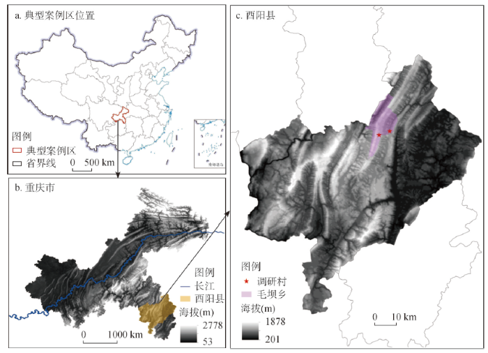
图1
典型案例区位置
注:基于自然资源部标准地图服务网站GS(2019)1823号标准地图制作,底图边界无修改。
Fig. 1
Location maps of typical case areas
2.1.3 其他相关数据
耕地撂荒数据来自于2015年和2018年中国科学院和西南大学开展的中国代表性地区耕地撂荒抽样调查,调查范围覆盖305个区县,包含了山区县和非山区县。山区县划分采用《中国县域经济统计年鉴》中的标准[26],即辖区的山地面积大于80%的区县,2020年中国山区县(区)有905个。脱贫县来源于国家乡村振兴局,以2018年2月份为准,中国共有脱贫县585个。生态环境脆弱区为实施退耕还林还草工程的区县[27]。该数据用于分析野猪“肇事”频发区、耕地撂荒区、脱贫区和生态环境脆弱区的空间分布特征。此外,典型案例区酉阳县1990年、2000年、2010年和2020年的植被生长季(4—10月)增强型植被指数(Enhanced Vegetation Index, EVI)是基于Google Earth Engine遥感云计算平台,并利用Landsat 5、Landsat 7和Landsat 8地表反射率数据计算所得,空间分辨率为30 m。
2.2 研究方法
2.2.1 荟萃分析法
荟萃分析法是基于前期的研究成果,对研究目的相同且相互独立的多个试验结果进行系统分析,并按照一定规律从宏观视角对现有研究中各数据进行统计,能够降低不同研究结论的差异性和无效性,减小负向研究结论的影响,提高原有研究的质量和价值。该方法已经在心理学、教育学、医学、景观学和地理学等社会科学与自然学科领域有所应用[28]。因而,荟萃分析法可用于对中国人—野猪冲突事件样本进行定量综合集成分析,提取人—野猪冲突事件的共性规律。以中国733件野猪“肇事”事件为基础,将第一起野猪“肇事”时点至今即2000—2021年划分为4个阶段,依次为2000—2005年、2005—2010年、2010—2015年和2015—2021年,分析不同时段野猪“肇事”的空间分布、危害和损失补偿等特征,并利用频次计数和空间分析法进行空间可视化分析。
2.2.2 植被指数计算
式中:
3 结果分析
3.1 人—野猪冲突年际变化
2000—2021年中国野猪“肇事”数量年际变化呈现明显递增趋势(图2),拟合曲线呈现指数函数形态(y = 5.8748e0.124x、R2 = 0.91)。野猪“肇事”大致经历了3个发展阶段,即在2003年以前,野猪“肇事”数量不超过10件/年,2004—2016年野猪“肇事”数量在20~40件/年,而2017年以后则超过40件/年,尤其2018年以后增长速度进一步加快,2021年甚至超过了100件,呈现向社会性风险发展的态势。
图2
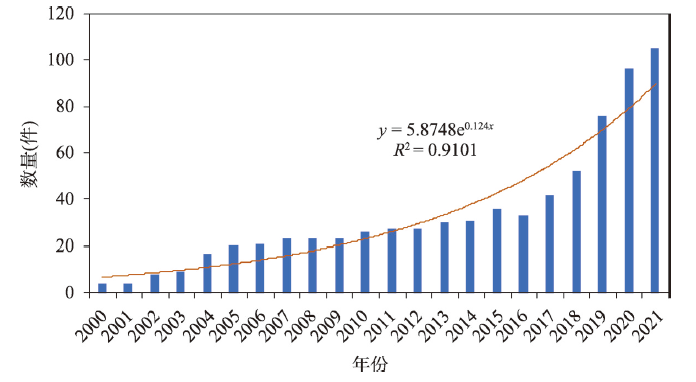
图2
2000—2021年中国人—野猪冲突事件数量
Fig. 2
Number of human-boar conflict incident from 2000 to 2021
3.2 人—野猪冲突区域分布
图3显示中国发生野猪“肇事”的区(县)数量由前期的67个增至近期的399个,所辖地级市从前期41个增至近期147个,省份数量由18个增至25个。其中,2000—2005年中国发生野猪“肇事”的区(县)为67个,主要分布在重庆市、湖北省和吉林省部分丘陵山区县,之后以重庆市和湖北省中西部为核心向四周扩张;2005—2010年新增野猪“肇事”区(县)42个,由重庆市和湖北省等地向安徽省、浙江省等地的丘陵山区县扩张;2010—2015年新增野猪“肇事”的区(县)为67个,在原来空间区域的基础上,继续向东部、东南部和西北部等山区县扩张;2015—2021年新增野猪“肇事”区(县)为223个,集中分布在四川省、贵州省、甘肃省东南部和陕西省中南部等丘陵山区县,逐渐形成当前野猪“肇事”的空间格局。值得注意的是,在近年发生野猪“肇事”的399个区县中,291个区县属于山区县,占比为72.93%。总的来说,野猪“肇事”事件多分布在以丘陵、山地为主要自然地理地貌形态的山区县。
图3
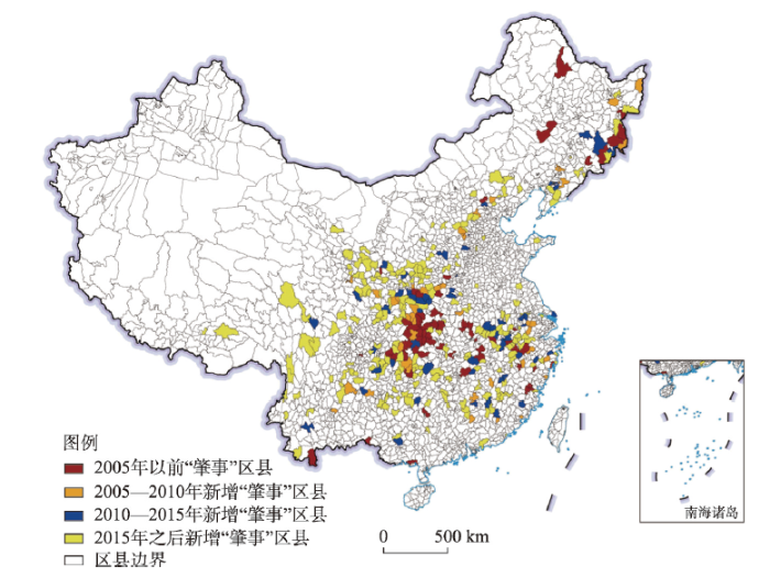
图3
2000—2021年中国县域尺度人—野猪冲突时空格局
注:基于自然资源部标准地图服务网站GS(2019)1823号标准地图制作,底图边界无修改。
Fig. 3
Spatiotemporal patterns of human-boar conflict at county level from 2000 to 2021
3.3 人—野猪冲突的危害特征
3.3.1 人—野猪冲突的危害类型
从当前中国各地发生的野猪“肇事”事件数量看,人—野猪冲突危害可分为破坏农作物(占比67.81%)、侵害家畜(8.53%)、致人受伤(19.32%)和致人死亡(4.34%)4种基本类型,而破坏农作物是其中最主要的类型(图4),其空间分布范围也最广(图5)。进一步统计显示,在发生野猪“肇事”的399个区县中,其中204个区县也发生过耕地撂荒现象,占比为51.13%,即野猪“肇事”与耕地撂荒具有较高的空间相关性。侵害家禽事件则多发生在长江沿线、贵州和湖南等地,致人伤亡事件多发生在长江沿线、陕西南部、黑龙江和吉林等地的丘陵山区县。值得注意的是,在中国399个野猪“肇事”记录的区(县)中,已有71个区(县)发生过野猪致人伤亡事件,占比约18%。
图4
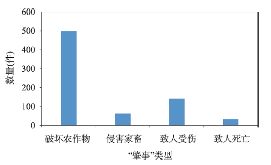
图4
2000—2021年间中国不同类型野猪“肇事”案例数量
Fig. 4
Number of wild boar damage incidents by different types from 2000 to 2021
图5
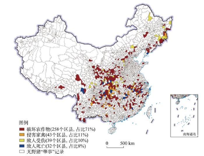
图5
县域尺度人—野猪冲突危害程度空间分布
注:基于自然资源部标准地图服务网站GS(2019)1823号标准地图制作,底图边界无修改。
Fig. 5
Spatial distribution of hazard degree of human-boar conflicts at county level
3.3.2 人—野猪冲突的典型案例
案例区天仓村和双龙村野猪“肇事”点与撂荒耕地的空间关系表明(图6):仅因野猪破坏导致撂荒的地块呈现“分布范围广、多零星分散”的格局,主要分布在海拔较高,与家庭住宅、水源地较远且植被覆盖茂密的区域,而因野猪破坏等多种因素导致撂荒的地块则呈现“分布相对集聚”的格局,主要分布在海拔较低,与公路、家庭住宅较近的平坝和槽谷等地。本文对案例区耕地撂荒进行了归因统计(表2):撂荒地块为282块,占总调研地块的64.53%;撂荒地块面积达22.61 hm2,占调研地块总面积的61.31%。无论是基于地块数量还是地块面积统计,2020年典型案例区的耕地撂荒率均超过60%。具体到撂荒的原因,其中仅因野猪破坏导致撂荒地块为85块,比重为30.14%;因野猪破坏和其他因素共同导致的撂荒地块为126块,比重为44.68%;非野猪破坏导致的撂荒地块为71块,占比约25%,即直接或间接受到野猪破坏造成的撂荒地块占比达到74.82%。同时,按照地块面积估算,直接或间接因野猪破坏造成的撂荒面积为80.15%。同样,对于双龙村而言,直接或间接因野猪破坏造成撂荒地块和面积占比分别达到80.4%和77.59%(表2)。
图6
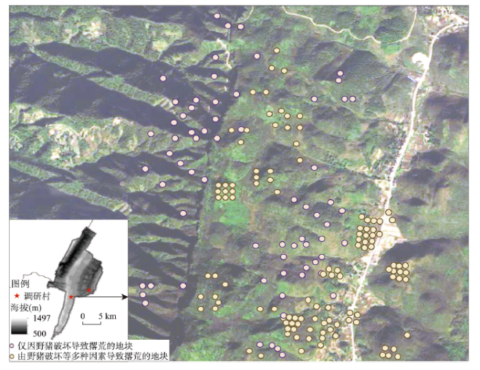
图6
案例区野猪“肇事”与撂荒耕地的空间关系
Fig. 6
Spatial relationship between wild boar damage and abandoned cultivated land in typical case areas
表2 典型案例区耕地撂荒的归因统计
Tab. 2
| 地块类型 | 天仓村 | 双龙村 | |||||||
|---|---|---|---|---|---|---|---|---|---|
| 地块数量(块) | 占比 (%) | 地块面积(hm2) | 占比 (%) | 地块数量(块) | 占比 (%) | 地块面积(hm2) | 占比 (%) | ||
| 仅因野猪破坏导致撂荒地块 | 85 | 30.14 | 7.24 | 32.01 | 37 | 18.59 | 4.06 | 19.48 | |
| 因野猪破坏等因素导致撂荒地块 | 126 | 44.68 | 10.88 | 48.14 | 123 | 61.81 | 12.13 | 58.11 | |
| 非野猪因素导致撂荒地块 | 71 | 25.18 | 4.49 | 19.85 | 39 | 19.60 | 4.68 | 22.41 | |
| 撂荒地块 | 282 | 100 | 22.61 | 100 | 199 | 100 | 20.87 | 100.00 | |
| 总调研地块 | 437 | 36.88 | 328 | 32.49 | |||||
注:非野猪因素包括家庭劳动力短缺、与家庭距离远、劣等地、自然灾害、水资源短缺、公路占用等因素。
此外,调研发现,1990年典型案例区酉阳县的两个调研村就发生过因野猪“肇事”导致耕地撂荒的现象,之后因野猪破坏导致撂荒的地块数量和撂荒面积均呈不断增加的趋势(图7)。其中撂荒地块数量由1990年的6块增至2020年的371块,相应地撂荒面积由0.11 hm2增至34.31 hm2。通过对1990—2020年酉阳县主要年份的EVI分析发现,20世纪90年代以来酉阳县的植被指数不断上升(图8),生态环境改善成效显著。总的来说,随着生态环境逐渐“好转”的同时,人—野猪冲突事件不断增加,因野猪破坏导致撂荒的耕地数量和面积也随之增加。当前,典型案例区野猪破坏农作物已成为当地耕地撂荒的主导因素之一,人—野猪冲突造成的耕地撂荒已十分严重。
图7
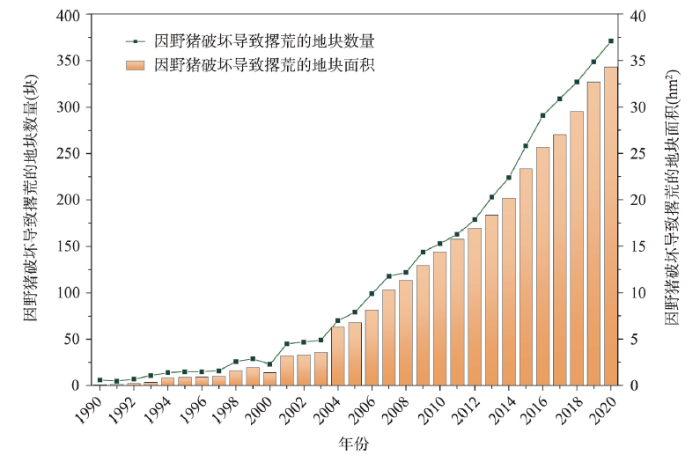
图7
1990—2020年典型案例区因野猪破坏导致耕地撂荒的规模统计
Fig. 7
Statistics of abandoned cultivated land caused by wild boar damage in typical case areas from 1990 to 2020
图8
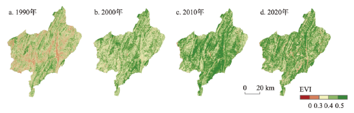
图8
典型案例区酉阳县主要年份EVI空间分布
Fig. 8
Spatial distribution of EVI in main years in Youyang County
4 讨论
4.1 人—野猪冲突的驱动因素
(1)生态工程实施与生态环境改善。为了改善生态环境,国家于1999年开始试点实施退耕还林还草工程。《中国退耕还林还草二十年(1999—2019)》白皮书显示,20年间中国实施退耕还林还草0.34亿hm2,生态环境得到显著改善[13]。1994年开始中国收缴猎枪,至今禁猎超过20年。2000年《国家保护的有益的或者有重要经济、科学研究价值的陆生野生动物名录》(国家林业局令第7号)将野猪列入国家“三有”保护动物名录范围,野猪的种群数量开始恢复。同时农户不能私自捕杀野猪,除了驱赶尚无其他有效方法,只能任由其大量繁殖,使得数量不断增长。
随着城镇化的推进,务农机会成本的持续上涨,农村青壮年劳动力选择外出务工。城镇每年新增人口约2100万人,而乡村人口持续减少,1995—2020年仅农业劳动力中国年均减少约1100万人,山区更为明显[31]。当前农村人口多以妇女、儿童和老人为主,对土地的依赖度明显减轻,土地利用方式和强度均发生变化,乡村生态环境逐渐“好转”[32]。比如,自20世纪90年代以来,乡村陆续逐渐使用煤气,农民对薪柴林的利用大幅减小[33]。加之受国家易地扶贫搬迁等政策影响,居住在山区尤其是深山的村民逐渐搬离大山,人类减轻了对山林的扰动,山区植被恢复和生态环境得到明显改善[32⇓-34]。山区生态环境改善给野猪创造了适宜的生存环境,野猪数量不断增加。
(2)农地—生态用地界线不清且交错分布。随着农业活动和城镇开发强度的增加,生态用地不断被农业用地和城镇用地侵占。人口增长对土地资源的需求越来越大,耕地不断向森林扩张,侵占了野猪原本的生存空间[18]。随着野猪生境范围的缩小,迫使野猪进入新的区域活动和觅食,继而林地边缘区的农作物成为野猪的破坏对象[11]。当前,野猪“肇事”热点区集中在四川盆地、黄土高原、长江中下游以及长白山等丘陵山区,且多为农林交错区,耕地与林地空间交错分布。与野生植物相比,野猪更偏爱农田里的食物,玉米、红薯和花生等农作物均为野猪的优质食物,在农作物接近成熟的季节,野猪便会进入农田取食,农作物遭到大面积破坏甚至绝收[10]。此外,近些年中国开展大规模生态保护红线的划定并于2020年底完成。生态保护红线的划定面积大、范围广和管控严格,这显著改善了生态环境,提升了生态系统服务价值,但也一定程度加剧了人—野猪冲突[11]。
(3)野猪生存力强且缺少天敌。野猪繁殖能力强,幼仔成活率高,平均产仔6~8头,在14~18月龄性成熟[19],性成熟早。《浙江省陆生野生动物资源调查报告》显示,2000年全省约有野猪2.9万头,2006年野猪数量超过10万头,到2010年浙江野猪数量达15万头,10年间野猪数量增长5倍。据估算,当前中国野猪数量超过100万头,部分地区呈现“泛滥”状态。野猪适应能力强,属于杂食性动物,食量较大[20]。野猪能快速适应不同的环境,多活动(如掘土、啃食农作物)在丘陵山区。由于野猪的天敌虎、豹、熊和狼等大型肉食性哺乳动物种群数量较少,且种群数量恢复缓慢,使得野猪缺少天敌[21],生存压力小,野猪数量快速增长。
4.2 人—野猪冲突与生态系统“反服务”
保护野生动物与保障人民生命财产安全之间的矛盾,是当下中国为实现人与自然和谐共生所面临的一个严峻挑战。因而,如何处理好生态保护与社会经济发展之间的关系,需要从生态系统服务视角进行审视[35-36]。一般而言,生态系统服务可分为“长效”服务和“短效”服务,其中“长效”服务是生态文明建设要实现人与自然和谐共生的最终目标,但要经过多个“短效”服务过程。然而,在生态环境逐渐得到恢复的过程中,生态系统对人类生产生活产生的不利影响逐渐显现,即生态系统“反服务”现象[37]。近年随着生态系统改善对人类产生的负面影响日益凸显,生态系统“反服务”问题逐渐得到学者的重视[13,37],但其概念仍无统一标准,一般认为生态系统“反服务”是生态系统产生的功能、过程和属性对人类福祉造成感知或实际上的负面影响[37],主要体现在生态系统过程或属性对人类福祉的直接影响、生态系统损害导致生态系统服务功能的降低、生态系统过程衍生的服务对人类福祉的负面影响等方面,如野生动物破坏农田、毒蛇伤人和花粉过敏等表现[13,37]。
生态系统“反服务”需要一些自然元素来组成一个生态系统,且这些元素会对人类造成不利的影响。依据生态系统“反服务”的特征和分类标准,可以判断,以野猪为代表的野生动物种群数量增多是生态系统“好转”的一种反映,但当野猪数量增加至会破坏农作物、侵害家禽或攻击人类,给当地居民生产生活带来负面影响时,则成为一种典型的生态系统“反服务”表现[10,13]。值得注意的是,当前中国的人—野猪冲突集中发生在丘陵山区的农林交错区,该区域与耕地撂荒严重区、脱贫区和生态脆弱区在空间上高度重合,即“四区叠加”,严重影响耕地撂荒治理、农户生计改善和区域生态安全水平提升,已成为当前最典型和最具代表性的一种生态系统“反服务”现象。
4.3 人—野猪冲突的调控策略
随着国家对生态保护力度的加大和各地生态环境的“好转”,以野猪为代表的野生动物对农村居民生产生活产生的负面影响已经由点及面扩散到中国丘陵山区县,导致约0.067亿hm2耕地面临弃耕、0.4亿t粮食产能受损,影响3000万农户生计。当下,地方政府应积极制定野猪种群数量调控的策略,并完善相应野猪“肇事”损失补偿机制,以缓解人—野猪冲突造成的危害,可以从以下方面着手:
(1)对野猪进行科学适度地捕杀。2021年12月10日,国家林业和草原局修订的《有重要生态、科学、社会价值的陆生野生动物名录》征求意见稿中剔除了野猪,这为野猪科学“捕杀”与阶段性保护提供法律支持。为科学适度地“捕杀”野猪,各地就野猪的“捕杀”时间、数量、范围和频率等均需要做详细论证,并在实施过程中加强监管。
(2)区别对待保护区内外的野猪。截至2020年中国自然保护地数量约1.2万个,约占陆地面积的18%,自然保护区内,野生动植物种群数量的调控应以保护野生动植物、保证生态系统的正常功能和生物物种的进化潜力为准则。由于野猪破坏自然保护区的植被,与其他草食动物竞争食物,在严格科学论证的前提下,需调节野猪的种群密度,可考虑在一些自然保护区引入野猪天敌,恢复生态系统的食物链,还可以开展节育之类的科学实验。在自然保护区之外82%的国土面积上,野生动植物种群数量的调控应以保障人类的生产生活和保护生命安全为准则,控制野猪数量过快增长。
(3)完善野猪“肇事”损失补偿机制。对野猪造成的损害进行赔偿是减轻野猪“肇事”的一种经济手段。经济补偿可以提高当地居民对野生动物的容忍度,减少报复性猎杀,有利于野生动物的保护同时平衡保护野生动物的成本和效益[38]。《野生动物保护法》第十九条规定:“因保护法规定保护的野生动物,造成人员伤亡、农作物或者其他财产损失的,由当地人民政府给予补偿。有关地方人民政府采取预防、控制国家重点保护野生动物造成危害的措施以及实行补偿所需经费,由中央财政按照国家有关规定予以补助”。但当前仅有北京、陕西、安徽和甘肃等省份实施了关于重点保护陆生野生动物造成的人身财产损失补偿办法,且存在补偿标准偏低、受损程度难以评估等问题。因此,政府应制定详细的损失评估标准、理赔制度,选择一些地区做试点后,尽快全面推广。
4.4 社会—生态系统的协同演进关系
借鉴人地关系演变机制的“支点”概念模型[39],本文对自然生态系统与社会经济系统的协同演进关系进行探讨。在一定的组织结构和技术水平下,自然生态系统—社会经济系统的演进受人类活动、气候变化等多种因素的共同影响。当特定区域的人类开展如退耕还林还草工程、禁猎等活动或气候环境变好时,该区域生态环境的“好转”为某种野生动物(如野猪)提供了良好的生存环境,野生动物种群数量快速增长,导致该区域耕地撂荒、农户生计水平下降甚至迫使农户外迁,同时进一步助长野生动物种群增长,表现出典型的生态系统“反服务”现象[11]。相反,当特定区域的人类开展如过度放牧或开垦等活动时,区域生态环境恶化,导致该区域生物多样性丧失和生物链失衡,如田鼠数量过多(天敌缺失)导致农作物歉收,农户生计可持续性下降,表现出典型的生态系统服务价值水平下降[39]。以上两种状态均为自然生态系统—社会经济系统的失衡状态,两个系统难以进行协同演进。只有当自然生态系统和社会经济系统处于一定平衡区间时,自然生态系统—社会经济系统才能协同演进,此时生态系统能够充分发挥出潜在的生态系统服务价值,从而促进人与自然和谐共生(图9)。
图9
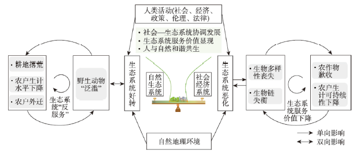
图9
社会—生态系统的协同演进关系
Fig. 9
Collaborative evolutionary relationship between society and ecosystem
5 结论与展望
2000—2021年中国人—野猪冲突事件的数量、空间范围和危害程度均呈递增趋势,涉及省、市和区(县)数量分别由早期的18个、41个和67个增至近期25个、147个和399个。初期集中在重庆市和湖北省中西部地区,之后向四周扩张,当前集中区转移到四川盆地、黄土高原、长江中下游以及长白山等丘陵山区,表现为破坏农作物、侵害家禽和致人伤亡等现象,其中破坏农作物是野猪“肇事”的主要危害,已经成为山区耕地撂荒的重要因素之一,而且致人伤亡比重较大,伤亡数量占整个野猪“肇事”数量的23.66%。
这一现象与生态工程、禁猎、农地—生态用地界线不清、野猪生存力强且缺少天敌等多种因素密切相关。近年国家开展大规模生态保护红线划定,生态保护空间划定的面积大、范围广和管控严格,在一定程度上助推了野猪的“泛滥”。生态恢复为人类提供生态系统服务的同时,也对人类产生了生态系统“反服务”作用。在以生态系统服务为主体语境下,开展生态系统“反服务”研究显得十分必要,可以让理论研究者和相关部门的实践者清晰认识到生态系统“好转”可能带来的消极影响,有助于完善生态系统综合管理的理论框架。
此外,人—野猪冲突反映在土地利用上,是以人为主体要素的生产空间和以野猪为主体要素的生态空间的冲突,本质上是人与野猪对特定区域土地资源或空间的争夺,给国土空间优化与管理带来巨大挑战。当前亟待加强对人与野猪等野生动物冲突问题的研究,尤其需要全面摸清冲突区受损耕地资源底数、定量评估野猪“肇事”对耕地撂荒、农户生计的影响以及系统揭示该类冲突对乡村振兴等方面的影响。
参考文献
Elephants in the village: Causes and consequences of property damage in Asia and Africa
Polar bear attacks on humans: Implications of a changing climate
DOI:10.1002/wsb.783 URL [本文引用: 1]
Large carnivore damage in Europe: Analysis of compensation and prevention programs
DOI:10.1016/j.biocon.2019.04.019
[本文引用: 1]

The mitigation of conflicts associated with large carnivore damage to livestock and agriculture is pivotal to their conservation. We evaluate current programs to compensate and prevent large carnivore damage in 27 European countries and the factors related to the economic costs of these programs. Overall, high compensation costs are associated with free-ranging livestock (68% of total costs) and with national economic wealth. Contrary to general belief, the return of large carnivores does not always translate into higher compensation costs. We identify a tendency towards prioritizing compensation over prevention; only a few wealthy countries pay the majority of the money allocated for prevention programs to adapt husbandry practices to the presence of large carnivores. We conclude that programs mainly focused on paying large compensation amounts will often fail to build tolerance towards predators. To mitigate conflicts and optimize the cost-effectiveness of publicly funded measures, responsible agencies should be proactive, focus on prevention-based policies and periodically evaluate the effectiveness of compensation and prevention programs in an adaptive manner. With this purpose and to identify further solutions for conflict mitigation, we call for a pan-European database of damage occurrence, management actions and associated costs.
Human-wildlife conflicts and the need to include tolerance and coexistence: An introductory comment
The political economy of human-wildlife conflict and coexistence
Unrecognized threat to global soil carbon by a widespread invasive species
DOI:10.1111/gcb.15769 URL [本文引用: 1]
Mechanistic understanding of human-wildlife conflict through a novel application of dynamic occupancy models
DOI:10.1111/cobi.12475
PMID:25757801
[本文引用: 1]
Crop and livestock depredation by wildlife is a primary driver of human-wildlife conflict, a problem that threatens the coexistence of people and wildlife globally. Understanding mechanisms that underlie depredation patterns holds the key to mitigating conflicts across time and space. However, most studies do not consider imperfect detection and reporting of conflicts, which may lead to incorrect inference regarding its spatiotemporal drivers. We applied dynamic occupancy models to elephant crop depredation data from India between 2005 and 2011 to estimate crop depredation occurrence and model its underlying dynamics as a function of spatiotemporal covariates while accounting for imperfect detection of conflicts. The probability of detecting conflicts was consistently <1.0 and was negatively influenced by distance to roads and elevation gradient, averaging 0.08-0.56 across primary periods (distinct agricultural seasons within each year). The probability of crop depredation occurrence ranged from 0.29 (SE 0.09) to 0.96 (SE 0.04). The probability that sites raided by elephants in primary period t would not be raided in primary period t + 1 varied with elevation gradient in different seasons and was influenced negatively by mean rainfall and village density and positively by distance to forests. Negative effects of rainfall variation and distance to forests best explained variation in the probability that sites not raided by elephants in primary period t would be raided in primary period t + 1. With our novel application of occupancy models, we teased apart the spatiotemporal drivers of conflicts from factors that influence how they are observed, thereby allowing more reliable inference on mechanisms underlying observed conflict patterns. We found that factors associated with increased crop accessibility and availability (e.g., distance to forests and rainfall patterns) were key drivers of elephant crop depredation dynamics. Such an understanding is essential for rigorous prediction of future conflicts, a critical requirement for effective conflict management in the context of increasing human-wildlife interactions. © 2015 Society for Conservation Biology.
Interpreting and predicting the spread of invasive wild pigs
DOI:10.1111/1365-2664.12866 URL [本文引用: 2]
Wild boar in the city: Phenotypic responses to urbanization
Wildlife damage and cultivated land abandonment: Findings from the mountainous areas of Chongqing, China
DOI:10.1016/j.cropro.2016.03.005 URL [本文引用: 8]
Game between ecosystem disservices and resident survival under ecological restoration: A case of the retreat of farmers led by the invasion of wild boars
DOI:10.11821/dlyj201804011
[本文引用: 6]
Research on ecosystem services (ES) to human wellbeing has increased over the last few years following the Millennium Ecosystem Assessment. These positive services have contributed reasonable decision-making suggestions for ecosystem reconstruction and restoration. However, the negative effects of ecosystem services on human wellbeing, termed ecosystem disservices (EDS), have been overlooked. In the recent few years, various EDS have been observed and discussed by western scholars. China has initiated several ecosystem restoration projects to conserve the environment and ecosystem as well as to promote ecosystem services, which have simultaneously brought nuisances to humans. Under the context of abundant studies on ES, EDS were concealed in researches and practices. We propose that EDS should be taken into account in China by a case study of the conflicts between the survival of countryside residents and invasion of wild boars, which took place in Tianshui and Longnan in the western Qinling range. In this area, 66% of villages were invaded by wild boars. The number of wild boars has increased under the forest restoration projects implemented in the recent 15 years. These restoration projects provided five types of EDS, including cropland damages from the invasion of wild boars, relocation of local inhabitants away from their original houses, abandonment of arable land, pressure of personal safety from wild boars, and probability risk of infection. The Game Theory model was employed to analyze the complex relationship between human survival and wild boar invasion as well as to determine the degree of EDS. The data of land use/cover and reforestation was obtained from remote-sensing images, and the negative effects of wild boars on local residents were obtained through interviews and questionnaires. The results showed that the improved ecosystem extended the area of forests toward the living areas of farmers and induced more wild animal activities in farmlands or living areas. Famers tried to maintain normal agricultural activities by avoiding the invasion of wild boars. The Game Theory model analysis provides the Nash equilibrium (prevention, invasion), which implies that wild boar invasion could not been avoided in the current situation. The government policies should focus on balancing the ecological restoration and human survival and as well as on improving and optimizing the resource allocation to help and compensate the loss of agriculture products. These approaches are the most effective ways to improve ecological construction, wild animal conservation, and farmer wellbeing. This research illustrates the significance of EDS and ES research in the process of ecological civilization construction in China. The Game Theory is one of the effective approaches to analyze the conflicts between human wellbeing and ecosystem restoration. Our results will also provide useful reference to the harmonious development strategies concerning ecological restoration and human survival in China.
生态恢复中生态系统反服务与居民生存的博弈: 以甘肃“猪进人退”现象为例
DOI:10.11821/dlyj201804011
[本文引用: 6]
生态系统为人类提供积极的生态系统服务的同时,也产生了消极的影响,如生态质量改善后野生动物数量增加并对居民生产和生活产生冲击的现象,此即生态系统反服务(EDS)。以西秦岭西汉水上游林区边缘的部分村庄为研究区,以“猪进人退”为案例,通过访谈和问卷调查、博弈论模型分析,试图揭示生态恢复建设过程中生态系统反服务给当地居民生存带来的消极影响和各利益方的博弈均衡结果。研究表明:案例区生态质量趋好背景下66%的村庄遭野猪侵害,其引致的EDS具体表现在5个方面,包括农田被毁、部分村民搬迁、耕地撂荒增加、村民人身安全受到威胁以及疾病传染威胁等;人类(包括村民和政府)在解决此问题时的纳什均衡为(防治,侵害),在生态效益目标不改变的情况下,野猪侵害行为不可避免,村民防治措施的有效性决定了村民对生态保护积极态度的程度。政府如果提高生态补偿,则可以达到村民和政府均积极保护生态、村民也积极防治野猪的理想模式。
A systematic review of the prevention and control measures on human-wild boar conflict
野猪与人冲突防控对策研究的系统评价
Hidden cost of conservation: A demonstration using losses from human-wildlife conflicts under a payment for ecosystem services program
Patterns of crop damage by wild boar (Sus scrofa) in Luxembourg over a 10-year period
DOI:10.1007/s10344-008-0183-x URL [本文引用: 1]
Differences in the activity pattern of the wild boar Sus scrofa related to human disturbance
DOI:10.1007/s10344-012-0661-z URL [本文引用: 2]
Characteristics of wild boar (Sus scrofa) mud bath sites on the northern slope of Funiu Mountain
伏牛山北坡野猪(Sus scrofa)泥浴场的生境特征
Efficacy of hunting, feeding, and fencing to reduce crop damage by wild boars
DOI:10.2193/0022-541X(2004)068[0939:EOHFAF]2.0.CO;2 URL [本文引用: 1]
Activity pattern and time budget of wild boars (Sus scrofa) in karst habitat
喀斯特生境中野猪活动模式和时间分配
Spatial distribution of human-wild boar conflicts in Jiangxi Province based on MaxEnt niche model
基于MaxEnt生态位模型分析江西省人与野猪冲突的空间分布
Expansion of human settlement in Kenya's Maasai Mara: What future for pastoralism and wildlife
DOI:10.1111/j.1365-2699.2004.01062.x URL [本文引用: 2]
Agroforestry, elephants, and tigers: Balancing conservation theory and practice in human-dominated landscapes of Southeast Asia
DOI:10.1016/j.agee.2004.01.009 URL [本文引用: 2]
Factors affecting crop damage by wild boar and methods of mitigation in a giant panda reserve
DOI:10.1007/s10344-008-0203-x URL [本文引用: 1]
Characteristics on devaluation of cultivated land and its mechanisms in typical mountainous areas of Chongqing, China
重庆典型山区耕地资产贬值特征及其发生机理
Farmland marginalization and its drivers in mountainous areas of China
Crop protection and conflict mitigation: Reducing the costs of living alongside non-human primates
DOI:10.1007/s10531-012-0318-y URL [本文引用: 2]
Extent and distribution of cropland abandonment in Chinese mountainous areas
DOI:10.18402/resci.2017.10.01
[本文引用: 1]
Cropland abandonment is the main land-use change in mountainous areas globally. It has profoundly altered rural land-use structure,agricultural landscapes,and farmer livelihoods in mountainous areas and has huge environmental and socioeconomic impacts. Since 2000,with the rapid rise in labor costs and the exodus of the rural labor force,croplands in China’s mountainous areas have been facing a greater risk of abandonment due to rough terrain and slow development of agricultural mechanization. Case studies and reports have increasingly demonstrated that cropland abandonment in these areas is severe. Considering that sloping croplands account for about 25% of total croplands in China,cropland abandonment is not only related to informed policy-making regarding land use and sustainable rural development in mountainous areas,but possibly has a significant negative impact on food security. Quantitative analyses of cropland abandonment at a national level in China have not been performed. Hence,in this study,a large-scale survey was carried out to estimate the extent of cropland abandonment in mountainous counties to offer a scientific basis for relevant policy-making and further study of cropland marginalization. The results show that 78.3% of 235 surveyed villages have experienced cropland abandonment to some extent. During 2014-2015,the abandonment rate of croplands in mountainous counties was 14.32%,showing a distribution pattern of “south-high and north-low” at the provincial level. The abandonment rate for the Yangtze River Basin was the highest,while that for the northeastern mountainous area was the lowest.
中国山区耕地撂荒程度及空间分布: 基于全国山区抽样调查结果
DOI:10.18402/resci.2017.10.01
[本文引用: 1]
耕地撂荒是当前全球山区主要的土地利用变化现象,它深刻地改变了山区农村土地利用结构、农业景观和农户生计,并带来了巨大的生态环境和社会经济效应。2000年以来,随着中国劳动力成本的快速上升和农村劳动力的大量析出,中国山区农业因地形限制,机械化发展受阻,耕地面临着较大的撂荒风险。越来越多的案例研究和报道表明中国山区耕地撂荒现象越演越烈。中国山区面积广、坡耕地比重大,耕地撂荒不仅关系到山区农地的合理利用政策和山区可持续发展政策的制定,并可能引起粮食安全问题,但目前仍缺少全国层面的定量化评估研究。因此,本研究通过开展大范围的抽样调查对中国山区县撂荒规模进行了推算,以期为相关政策制定以及耕地边际化进一步研究提供参考。研究结果表明,在235个调查村庄中,78.3%的村庄出现耕地撂荒现象;基于县样本统计的2014-2015年全国山区县耕地撂荒率为14.32%;山区耕地撂荒率在省级尺度上呈现出南高北低的空间格局,其中,长江流域一带的山区耕地撂荒率最高,东北的长白山区最低。
The impacts of the Grain for Green Project on the trade-off and synergy relationships among multiple ecosystem services in China
中国退耕还林还草对生态系统服务权衡与协同的影响
Spatio-temporal pattern of cropland abandonment in China from 1992 to 2017: A meta-analysis
DOI:10.11821/dlxb201903001
[本文引用: 1]
Cropland abandonment has increasingly occurred in China, which potentially affects national food and ecological security. This study collected existing publications focusing on cropland abandonment. Then, we extracted the key characteristics of cropland abandonment events, including time, location, magnitude, and driving force. The meta-analysis was carried out on these items to disclose the spatio-temporal pattern and main drivers of cropland abandonment in China in the last three decades. We found that there were a total of 163 counties in which cropland abandonment occurred according to the existing literature. These counties were mostly located in southern China and, in particular, exhibited a pattern of a T-shape on 90 degree anticlockwise rotation. The vertical axis exhibited a north-south belt across southeastern Gansu Province, eastern Sichuan Province, Chongqing, western Guizhou Province, and northern Yunnan Province. The horizontal axis exhibited a west-east belt along the middle to lower reaches of the Yangtze River across southern Hubei Province, northern Hunan Province,w and central to southern Anhui Province. In the provinces of Hunan, Sichuan, and Anhui, cropland abandonment can be found in 24, 23, and 21 counties, respectively; in Hubei, Chongqing, Fujian, Gansu, and Yunnan provincial-level areas, there are more than 10 counties with cropland abandonment. The formation of the “T” structure underwent two stages. Before 2010, there were 102 counties with cropland abandonment that mainly existed along the middle to lower reaches of the Yangtze River, where the horizontal axis occurred. Since 2010, there have been 63 counties with cropland abandonment, mostly existing in the north-south belt from southeastern Gansu to northern Guizhou, where the vertical axis occurred. The spatio-temporal patterns of cropland abandonment events matched well with the labor emigration from agriculture in the context of regional economic development and industrial restructuring. The low economic efficiency of agriculture and the shortage of agricultural labor are two common drivers leading to cropland abandonment in 86% and 78% of counties, respectively.
1992—2017年基于荟萃分析的中国耕地撂荒时空特征
DOI:10.11821/dlxb201903001
[本文引用: 1]
当前耕地撂荒已成为一种日益普遍的土地利用变化现象,对粮食安全和生态环境具有重要影响。为揭示1992-2017年中国耕地撂荒的时空特征及驱动机制,采用集成分析的思路,对县(市)域尺度撂荒的研究成果进行了汇总梳理,从中提取撂荒时间、位置、规模(程度)、成因等信息,并进行了荟萃分析。结果发现:1992-2017年全国范围内有撂荒记录的县(市)共165个,主要分布于南方,集中分布区呈逆时针旋转90°的“T”字型,纵轴自北至南贯穿甘肃东南部、四川东部、重庆境内,直至贵州西部和云南北部;横轴位于长江中下游地区,自西向东贯穿湖北、湖南、安徽、江西。其中,湖南、四川、安徽有撂荒记录的县(市)数量较多,分别为24个、23个、21个,其次是湖北、重庆、福建、甘肃、云南,均超过10个。“T”字型结构的形成经历两个阶段,大致以2010年为界,此前有撂荒记录的县(市)为102个,集中分布于沿长江中下游的东西向带状区域,形成横轴;此后新增63个县(市),集中分布于自甘肃东南部至贵州西部和云南北部地区的南北向带状区域,形成纵轴。撂荒格局的形成过程与区域经济发展和产业结构调整背景下的农业劳动力析出基本同步。农业收益低和劳动力不足分别是86%和78%的县(市)撂荒形成的共性因素。
Comparison the accuracies of different spectral indices for estimation vegetation cover fraction in sparse vegetated areas
DOI:10.1016/j.ejrs.2011.06.001 URL [本文引用: 1]
Spatio-temporal variation of vegetation cover and its relationship with climatic factors and human activities in the Southwest Tibetan Plateau
DOI:10.13249/j.cnki.sgs.2022.05.002
[本文引用: 1]
Exploring vegetation cover changes in alpine regions and their influencing factors has become one of the focal issues for scholars at home and abroad. Based on MODIS-NDVI data and meteorological data, this study analyzed the spatial and temporal characteristics of vegetation NDVI in the Southwest Tibetan Plateau (SWTP) from 2000 to 2020 and the effects of climate change and human activities on vegetation NDVI by using trend analysis, correlation analysis and residual analysis. The results showed that NDVI in the SWTP has been increasing in the past 20 years. There are obvious differences in the growth rates of vegetation NDVI in different time periods mainly as follows: autumn > growing season > summer > whole year > spring > winter; although there are differences in the distribution pattern of vegetation NDVI in different time periods, the vegetation cover in the eastern part of the plateau is significantly higher than that in the western part. The vegetation status is basically stable in most areas of the plateau, with significant local improvement and degradation in some areas. On the interannual scale, the increase of temperature and precipitation led to the increase of vegetation NDVI, and on the seasonal scale, the increase of temperature in spring, autumn and winter led to the increase of vegetation NDVI, and the increase of precipitation leads to the decrease of vegetation NDVI, and the increase of temperature in summer and growing season led to the decrease of vegetation NDVI, and the increase of precipitation leads to the increase of vegetation NDVI. Human activities have a positive impact on most areas of the plateau, and a negative impact in some areas, concentrated in counties with semi-agricultural and semi-pastoralism and purely pastoralism.
藏西南高原植被覆盖时空变化及其与气候因素和人类活动的关系
DOI:10.13249/j.cnki.sgs.2022.05.002
[本文引用: 1]
研究基于MODIS-NDVI数据和气象数据,利用趋势分析、相关分析及残差分析等方法,分析了2000―2020年藏西南高原植被NDVI在不同时段的时空变化特征及气候因素和人类活动对植被NDVI的影响,结果表明:近20 a来藏西南高原植被NDVI呈增加趋势,不同时段植被NDVI增长速率存在显著差异,主要表现为秋季>生长季>夏季>全年>春季>冬季;不同时段植被NDVI的分布格局虽存在差异,但高原东部植被覆盖度明显高于西部地区;高原大部分区域植被状态基本稳定,局部明显改善,部分区域有所退化;年际尺度上,气温和降水的增加导致植被NDVI升高,季节尺度上,春季、秋季和冬季气温升高导致植被NDVI升高,降水的增加导致植被NDVI下降,夏季和生长季气温升高导致植被NDVI下降,降水升高导致植被NDVI增加;人类活动对高原大部分区域呈正面影响,局部地区呈负面影响,集中分布在半农半牧和纯牧业县区。
Impacts of rural-urban migration on vegetation cover in ecologically fragile areas: Taking Inner Mongolia as a case
DOI:10.11821/dlxb201510007
[本文引用: 1]
Improving the quality of environment in ecologically fragile areas had been paid much attention by scholars and government at different levels. Over the past decade, a large number of rural labors had migrated into urban areas. To what extent would the migration affect the changes of vegetation cover in ecologically fragile areas? In this study, we analyzed the spatio-temporal variation of vegetation cover and its relationship with human activities at the county level based on the NDVI data with a resolution of 1 km, meteorological data and economic data from 2000 to 2010 in Inner Mongolia. The major methods included trend line analysis method, significance testing and multi-regression analysis method. The main conclusions were as follows: (1) The vegetation cover of the study area increased by 10.1% during 2000-2010. More than 28% of the vegetation cover increased significantly, and only about 2% decreased evidently during the study period. (2) The area with significant degradation presented a banded distribution in the northern fringe of farming-pastoral ecotone in the central part of Inner Mongolia. It is shown that the ecological environment is still fragile in this area, which should be focused on. The area where vegetation cover significantly improved showed a concentrated distribution in the southeast and west of Inner Mongolia. (3) Effects of agricultural labor on vegetation cover had exceeded those of natural factors such as climate. The emigration of agricultural labor had improved vegetation cover significantly.
乡村人口迁出对生态脆弱地区植被覆被的影响: 以内蒙古自治区为例
DOI:10.11821/dlxb201510007
[本文引用: 1]
生态脆弱地区的生态环境状况改善和治理一直是各级政府部门和学者关注的焦点问题。过去10余年,中国城镇化进程发展迅速,生态脆弱地区乡村劳动力大量迁出。那么劳动力人口迁出会在多大程度上影响脆弱地区植被覆被状况的变化呢?本研究利用2000-2010年的NDVI数据、气象观测数据和社会经济数据,采用趋势线分析、显著性检验和多元回归分析等方法,对内蒙古地区植被覆被状况的变化进行了分析,并在县级尺度上定量评估了乡村劳动力人口迁移对区域植被覆被状况的影响。结果表明:① 2000-2010年,内蒙古自治区植被覆被总体呈上升趋势,其中超过28%的地区植被覆被状况显著改善,只有约2%的地区存在较强的退化趋势;② 植被覆被显著退化的地区呈条带状分布于内蒙古自治区中部农牧交错带北部边缘;植被覆被显著改善的地区主要位于内蒙古自治区的东南部与西部地区;③ 2000-2010年,农业劳动力对植被覆被状况的影响已经超过了气候等自然因素的作用,农业劳动力迁出对植被覆被状况提高有显著的促进作用。
Influences of population pressure change on vegetation greenness in China's mountainous areas
DOI:10.1002/ece3.3424
PMID:29152196
[本文引用: 2]
Mountainous areas in China account for two-thirds of the total land area. Due to rapid urbanization, rural population emigration in China's mountainous areas is very significant. This raises the question to which degree such population emigration influences the vegetation greenness in these areas. In this study, 9,753 sample areas (each sample measured about 64 square kilometers) were randomly selected, and the influences of population emigration (population pressure change) on vegetation greenness during 2000-2010 were quantitatively expressed by the multivariate linear regression (MLR) model, using census data under the condition of controlling the natural elements such as climatic and landform factors. The results indicate that the vegetation index in the past 10 years has presented an increasing overall trend, albeit with local decrease in some regions. The combined area of the regions with improved vegetation accounted for 81.7% of the total mountainous areas in China. From 2000 to 2010, the rural population significantly decreased, with most significant decreases in the northern and central areas (17.2% and 16.8%, respectively). In China's mountainous areas and in most of the subregions, population emigration has significant impacts on vegetation change. In different subregions, population decrease differently influenced vegetation greenness, and the marginal effect of population decrease on vegetation change presented obvious differences from north to south. In the southwest, on the premise of controlling other factors, a population decrease by one unit could increase the slope of vegetation change by 16.4%; in contrast, in the southeastern, northern, northeastern, and central area, the proportion was about 15.5%, 10.6%, 9.7%, and 7.5%, respectively, for improving the trend of NDVI variation.
Effects of population spatial redistribution on vegetation greenness: A case study of Chongqing, China
Spatial redistribution of populations in mountainous areas and its impact on vegetation change in southwest China: A riverside case study
西南山区人口空间重组及其对植被的影响: 以河流沿线为例
The tradeoffs and synergies of ecosystem services:Research progress, development trend, and themes of geography
Due to the diversity of ecosystem services, the heterogeneity of the spatial distribution and the selectivity of human use, the mutual relationships between ecosystem services show the dynamic variation under the influence of human activities and natural factors, which are characterized by different patterns such as reciprocal tradeoffs and mutual gain synergies. Understanding types, formation mechanism, scale dependence and regional differences of tradeoffs and synergies among the ecosystem services has great significance on formulating "win-win" policies and the implementation of measures for regional development and ecological protection. Therefore, the domestic and international research progress and limitation in interactions and nonlinear relationships, types, formation mechanism, scale effects, methods and tools, and uncertainty of ecosystem services were systematically reviewed in this paper. Furthermore, the research trend was identified, and the research issues on the tradeoffs and synergies of ecosystem services were put forward from a geographic perspective including spatial-temporal heterogeneity, formation mechanism, scale-dependence and regional differences. This paper will help to expand the research depth and breadth on tradeoffs and synergies of ecosystem services, and promote the level of geography comprehensive study.
生态系统服务权衡与协同研究进展及地理学研究议题
由于生态系统服务的多样性、空间分布的不均衡性以及人类使用的选择性,在人为活动和自然因素作用下,服务之间的关系出现了此消彼长的权衡、相互增益的协同等变化。理解服务权衡与协同的表现类型、形成机理、尺度依存和区域差异,对于制定区域发展与生态保护"双赢"的政策措施具有重要意义。从相互作用与联系、类型与形成机制、研究方法与工具、尺度效应以及不确定性等方面评述了生态系统服务权衡与协同的国内外研究进展和局限性,并对研究趋势进行了展望。在此基础上,提出从地理学视角研究生态系统服务权衡与协同的主要议题,包括服务供需的时空异质性、权衡与协同的形成机制、尺度依存和区域差异等。可为拓展生态系统服务权衡与协同研究的深度和广度,提升地理学综合研究水平提供借鉴与参考。
The value of ecosystem services in China: A systematic review for twenty years
Unpacking pandora's box: Understanding and categorizing ecosystem disservices for environmental management and human wellbeing
DOI:10.1007/s10021-015-9952-z URL [本文引用: 4]
An investigation of residents' acceptance of wild boar and influencing factors in Hunchun Natural Reserve
Natural reserve plays important role in the conservation of endangered species. However, natural reserves usually have conflicts with local residents in conservation and resource utilization. Community-involved management has already been well recognized. A key factor influencing the willingness of local communities to be involved in the management is their acceptance of pest species that is an important component in the ecosystem of the reserve. In Hunchun Natural Reserve targeting the conservation of tiger, the wild boar (sus scrofa ussuricua) is a major prey species of tiger and thus is critically important for tiger conservation. The population of wild boar increased rapidly in the past years in this area, and engendered destruction of residents crops. Therefore, appropriate solution for the conflict between human and wild boar is essential for the conservation of tiger.We interviewed residents by stratified sampling and releasing 302 effective questionnaires. of the analysis of interviews and 302 effective questionnaires indicates that 1) 96.35% of residents expected that wild boar population could reduced or be eliminated; 2) 99.34% of ersidents strongly agreed or agreed to kill wild boars when their crops were depredated; 3) 86.09% of residents strongly agreed or agreed to kill wild boars when encountering wild boars in their village; 4) 48.7% of residents strongly agreed or agreed to kill wild boars when they are seen in the mountains and 48.68% of residents were neutral. Meanwhile, the acceptance of the wild boar was not significantly different between residents inside and outside the natural reserve, and between communities involved in reserve management despite of inside and outside the management region. It is conclusive that local people had very poor acceptance of wild boar. The analysis also indicates that the area of farmland, the extent of wild boar destruction on their farmland and the frequency of wild boar encountering with local people are the main factors influencing the acceptance. Gender and education levels are not influential to the acceptance. This investigation suggested that the management should primarily focus on the solution of conflicts of resources use, rather than purely on public education.
珲春自然保护区居民对野猪的容受性及其影响因素分析
针对保护区居民与野猪冲突日益严重的现状,该论文采用座谈访问的形式,调查研究了珲春自然保护区居民对野猪的容受性,并对影响居民容受性的因素进行了分析。302份有效问卷的分析结果表明:96.35%的居民期望种群消灭或下降;在农田被野猪破坏后,99.34%的居民强烈同意或同意捕杀野猪;在村野遇见野猪后,86.09%的居民强烈同意或同意捕杀野猪;在山上遇见野猪后,48.7%的居民强烈同意或同意捕杀野猪,48.68%持中立态度。保护区内与保护区外居民、保护区外社区共管区与社区共管区外居民对野猪的容受性并无显著差异。土地面积、野猪破坏农田面积、遇野猪次数是影响居民对野猪容受性的主要因素,性别、文化程度并不是影响居民对野猪容受性的主要因素。
Using the fulcrum cognitive model to explore the mechanism of past human-land co-evolution
DOI:10.11821/dlxb202101002
[本文引用: 2]
The trajectory, pattern, and mechanism of the human-land co-evolution process is a critical issue in the field of human geography. The pattern of human-environment interaction has varied significantly during different phases of human evolution, suggesting a series of changes in the driving force of human-land co-evolution. Although a variety of underlying mechanisms specific to the key periods of human history (e.g., Paleolithic, Neolithic, Bronze, and historical ages) have been intensively investigated, there are still significant gaps in the widely accepted model of the fundamental law that governs human-land co-evolution across human history. In this paper we propose the Fulcrum Cognitive Model (FCM), with the objective of disentangling the mechanism of human-land co-evolution. The FCM focuses on the equilibrium between the natural ecosystem and human social system, which can be disturbed by both climatic/environmental change and human activities, and restored by an adjustment of the human social system. Moreover, we propose a "quantitative-change equilibrium pattern" and "qualitative-change equilibrium pattern" on the basis of FCM, to further describe the mechanism of past human-land co-evolution in different contexts. In the former pattern, a new equilibrium between the natural ecosystem and human social system is rebuilt by the corresponding changes in population size, without a shift in the fulcrum position. In contrast, in the latter pattern, societies improve their social resilience to the deterioration of the living environment through social and/or technological changes. In this case, the fulcrum position of the original equilibrium shifts and the pattern of human-environment interaction is transformed. Social resilience is gradually strengthened during the evolutionary process and the dominant influencing factor moves from natural causes towards anthropogenic factors. To test its feasibility, we applied the model to the changing patterns of the human-land relationship in Shanxi, Shaanxi, and Henan provinces in central north China between the Yangshao period (~5000-3000 BCE) and Zhou Dynasty (1046-256 BCE), based on a comprehensive analysis of updated archaeological and paleoclimatic data. The results suggested that the mechanism controlling the human-land relationship during ~4000-2600 BCE and 2600-256 BCE could be explained by the "quantitative-change equilibrium pattern" and "qualitative-change equilibrium pattern", respectively. The mechanism of human-land co-evolution in the past is very complicated and the interaction of these two patterns may vary in terms of its spatiotemporal scale, which will require further study in the future.
探讨过去人地关系演变机制的“支点”概念模型
DOI:10.11821/dlxb202101002
[本文引用: 2]
人地关系演变的历史、规律和机制是地理学研究的重要科学问题。在人类社会演化的不同阶段,人与环境相互作用的模式存在显著差异,揭示人地关系在时间维度上的演变轨迹和机制可为有效衔接古今人地关系研究提供重要依据。基于对过去人地关系研究案例的分析和总结,我们提出“支点”概念模型尝试解释人地关系演变的规律和机制。当特定区域人口数量增长到一定程度时,自然生态系统和人类社会系统达到平衡状态,随后的气候环境变化和人类活动变化都有可能打破其平衡状态。人类社会系统在面对生存环境变化压力时可能出现两种不同方式的响应:① 通过人口数量的调节适应生存环境变化而达到新的平衡,其特点是人与环境相互作用的模式(人类社会与自然生态系统平衡“支点”位置)不变;② 通过人类社会组织结构或技术革新方式使社会适应生存环境变化的“韧性”增强,体现为人与环境相互作用模式发生改变。随着时间的推移,社会韧性呈增强趋势,人地关系演变的主导因素也整体呈现由自然因素向人为因素的偏移。最后,以河南、山西和陕西三省仰韶文化时期(约公元前5000—公元前3000年)至周代(公元前1046—公元前256年)的人地关系研究为例,运用“支点”概念模型分析了其演变机制。
