

1 引言
复杂地形山区通常是大江大河的源头,占中国陆域面积的65%以上,其水资源的精准评价与预测关乎水文安全、经济发展等诸多涉及生态文明建设、脱贫攻坚等时代议题的关键环节[1]。在气候变化的背景下,水资源的可持续管理决策,需要考虑其组分空间分布的异质性。降水是水资源的核心,降水数据是驱动陆面过程、水土污染运移、水文循环等模型的关键性变量[2]。而高时空分辨率的降水数据作为陆地表层格局与过程模拟的重要参数,其数据精度直接影响科学决策的信度。但是,复杂地形山区内部存在多种地形要素对降水的空间分布产生影响,如山体坡面对湿润气流的阻滞、抬升作用,连绵山体之间山谷对干燥空气的聚集、通道作用。因此复杂地形山区的降水格局呈现显著异质性,单点气象站观测值的空间代表性也受到限制。加之山地地区气象观测站因架设维护困难而分布稀疏,导致山区普遍面临着长时序、高精度和高分辨率的气象观测数据稀缺的问题[3]。大气再分析资料和遥感数据产品空间覆盖广且时间连续,近年来常被作为降水驱动的相关模型的输入数据[4]。然而,遥感与大气再分析资料往往与地面真实数据有着较大偏差[5],且其最高空间分辨率为0.05°(CHIRPS)[6],刻画降水随小尺度地形起伏变化的能力仍旧不足,难以满足流域尺度模型的精度要求。空间插值是细化降水资料的传统手段。然而,传统插值方法有些只考虑观测站点间的空间关系而忽视了高程效应,如基于观测站点空间位置关系的反距离权重法[7]、泰森多边形法[8]及基于观测值空间统计特征的普通克里金法[9];有些能够考虑高程和坡向,但对地形部位不做区分,如基于多变量互作用关系的多元线性回归法[10]、以高程作为约束项的协同克里格方法[11]及考虑坡向和高程改进的角距加权算法[3];特别是部分模型缺乏与先验知识的充分结合[12-13],在观测站点稀疏、地形起伏剧烈的地区难以得到可靠的结果。
1994年Daly等提出一种能够考虑多种地形要素的插值方法PRISM(Parameter-elevation Regressions on Independent Slopes Model),并在之后的实际应用中被不断丰富完善[14⇓-16]。该方法认为在不同地形要素组合中,高程与降水存在不同的线性关系。因此通过观测站点与待插值点所在区域地形要素的差异,调节观测站点的权重大小,控制其在线性回归过程中的重要程度。PRISM计算框架更为灵活,为所要考虑的地形要素的增减留有空间。基于该方法,Daly等生产了美国内陆地区的气温降水800 m格网数据,并一直更新维护了一套美国内陆地区4 km分辨率降水产品(
美国加利福尼亚州及中国西南青藏高原周边等热带、亚热带山区的山谷下部受山体阻滞作用影响形成的干旱少雨的“雨影区”,被称为干旱河谷。中国干旱河谷根据不同的自然地理区及热量条件,还可分为干热河谷、干暖河谷和干温河谷。其中,干热河谷是指山谷下部与周围区域相比呈现出明显“干”“热”特征的纵伸深切河谷,主要分布在西南金沙江支流、雅砻江和元江[20]。其中,元江流域内河谷与相邻山脊区域多年降水均值相差可达1500 mm,是复杂地形影响下降水在空间上呈现强烈异质性的典型代表。降水不足导致的脆弱生态环境严重威胁干旱河谷区的农业及生态系统的可持续发展。而相比干旱河谷,干热河谷的干旱与高温协同作用,造成的威胁比干旱或高温单一因素作用更为严重[21]。在人类干扰的不断加强以及极端气候事件可能增多的背景下[22],这种威胁还可能进一步加剧[23]。干热河谷区尤其需要高分辨率降水资料,为区域生态环境的现状评估和趋势预测提供科学支撑。但是,目前中国西南干热河谷区降水数据多采用观测站点数据和粗分辨率的格网数据产品[24⇓⇓⇓-28]。降水驱动的陆面过程模型在干热河谷区的应用尚未得到深入研究,降水数据产品的局限性也尚未得到重视。
鉴于此,本文以元江干热河谷区的元江流域为例,针对目前PRISM存在的第一个不足,结合复杂地形影响局地降水模式的机制及特征,将原PRISM算法中有效地形高度参数拆分为大尺度地形起伏度和小尺度地形起伏度两个参数,提升了PRISM刻画中小尺度地形地貌的能力;考虑目前PRISM存在的第二个不足,将改进后的PRISM嵌入“平均态日降水—比值”插值框架;构建了适用于复杂地形下日降水高空间分辨率插值的算法MPRISMR (Modified PRISM-Ratio of actual to mean daily precipitation)。随后基于“留一法”交叉验证及与ERA5-Land和TRMM_3B42降水产品的对比分析,检验了MPRISMR算法的可靠性与插值结果准确性。最后生成了2000—2018年元江流域首个空间分辨率约3km的逐日高分辨率降水数据集,以期为陆面过程模型的应用提供数据支撑。
2 数据来源及研究方法
2.1 研究区概况
中国西南干旱河谷是横断山区及其南延山系一种独特的自然景观和生态系统类型,沿怒江、澜沧江、元江、金沙江及其支流雅砻江等河谷的部分地段分布[20]。其中,元江位于中国云南省境内,是国际性河流红河上游的主要干流。元江流域面积占红河流域面积的45%,地理位置处于22.5°N~25.5°N、100.0°E~106.0°E(图1a)。流域整体地势自西北向东南倾斜,高差可达1500 m;西北—东南走向的山脉与山谷相间分布,构成了对湿润气流运动产生剧烈影响的“地形波”,其中哀牢山平均海拔最高,与其北侧元江干热河谷的脊—谷差最大达到1600 m。流域总体上属于亚热带气候,年降水量在1230 mm左右,时间和空间分配都相对不均。从时间分布上看,元江流域年内降水分为明显的干湿两季,85%的降水集中在湿季;从空间分布上看,在水平与垂直地带性的影响下,元江流域降水总体呈由河谷向山脊、由上游至下游递增的趋势,海拔2800 m左右的哀牢山区与海拔900 m以下的哀牢山北麓平均年降水量相差达1300~1400 mm,元江发源地巍山县与下游河口县年平均降水量相差近750 mm。同样受气候区及地形影响,元江流域河谷地区气温较高,年平均气温24.7 ℃,最高气温43.7 ℃,全年有100 d以上温度超过35 ℃(中国科学院西双版纳热带植物园元江干热河谷生态站2012年1月至2017年12月观测结果)。因此,元江流域的干旱河谷可以被进一步归为干热河谷。河谷区极端气候条件造成了脆弱的生态环境,而在河谷外,人类扰动较少,拥有众多的自然保护区,为大量野生动植物提供了栖息地。
2.2 数据来源
本文所需数据主要涉及气象观测数据和高程地形数据。气象观测数据来自中国地面气候资料日值数据集,时间跨度为1951—2018年,日值数据的记录时间为前一日12时至当日12时(UTC)。该数据集在全国共有2480个气象站点,但其分布不均,在高原山区分布稀少,分布在元江流域的仅有23个,其中位于干热河谷谷底的站点仅有3个(图1c)。鉴于此,本文扩大了参与插值的站点的选取范围,最终选取中国西南地区干旱河谷所在流域内及周边共458个气象站点(图1b)。中国西南地区干旱河谷边界来自范建容等[29]。流域划分边界数据来自国家冰川冻土沙漠科学数据中心(
图1
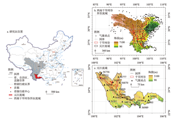
图1
中国西南干旱河谷所在流域及元江流域地理位置及其气象站点分布
注:图a基于自然资源部标准地图服务网站GS(2016)1606号的标准地图制作,底图边界无修改。
Fig. 1
Geographical location of the river basin with arid valleys of Southwest China and Yuanjiang River basin and the spatial distribution of the meteorological observation stations
为了对本文数据产品精度进行验证分析,研究选取ERA5-Land (Enhanced global dataset for the land component of the 5th generation of European ReAnalysis)[30-31]和TRMM_3B42 (TRMM (TMPA) Rainfall Estimate L3 3 hour 0.25 degree x 0.25 degree)[32-33]数据集作为对比。前者由欧洲中期天气预报中心(ECMWF)对第五代全球大气再分析数据集(ERA5)进行融合生成。ERA5系列产品提供了1950年至今的小时尺度全球降水数据,是目前时间跨度最长的高时空分辨率大气再分析产品,已经被广泛应用于相关模型并取得了良好的模拟结果[34-35]。ERA5-Land数据在ERA5数据基础上进行了一系列改进,将空间分辨率从约31 km提升到了约9 km。与结合物理过程和地面站点观测数据同化生成的大气再分析资料不同,遥感降水产品由卫星的对地观测数据反演生成。TRMM是全球第一颗搭载测雨雷达的卫星,由美国国家航空航天局(NASA)和日本空间探索中心(JAXA)共同发射,其多卫星降水分析(TRMM Multi-satellite Precipitation Analysis, TMPA)产品TRMM_3B42版本融合了微波和红外降水传感器观测值以兼顾时间和空间分辨率。其他遥感降水观测数据还包括TRMM的下一代GPM(Global Precipitation Measurement),代表产品为IMERG-F(Integrated Multi-satellite Retrievals for GPM-Final);结合多颗卫星观测值的GSMaP(Global Satellite Mapping of Precipitation),代表产品为GSMaP-GAUGE(GSMaP gauge-adjusted);以及中国的风云FY-2(FengYun-2)等。Yuan等针对TRMM、GPM、GSMaP的降水产品在缅甸开展的两次对比研究表明,TRMM_3B42数据精度相对较高[36-37]。此外,TRMM系列数据具有时间序列长(1997.12.31—2020.01.01)的优势。因此,考虑元江流域与缅甸邻近,且具有相似地形与气候条件,本文选择TRMM_3B42数据作为遥感降水产品的代表(表1)。
表1 大气再分析和遥感降水产品信息
Tab. 1
2.3 研究方法
图2
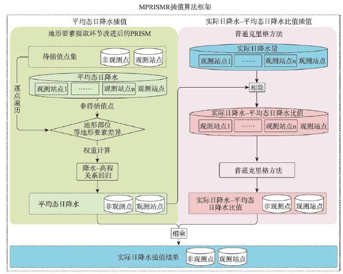
图2
MPRISMR插值算法框架概念图
注:蓝色背景框表示实际日降水观测值或插值结果,绿色背景框表示由观测值计算或插值得到的平均态日降水,粉色背景框表示实际日降水—平均态日降水比值。
Fig. 2
Conceptual workflow of MPRISMR interpolation algorithm
在以元江流域为例的2000—2018年日降水插值过程中,MPRISMR的具体应用流程如下。首先计算各观测站点2000—2018年多年日降水观测数据的多年平均日降水,然后对其进行傅里叶变换,定义前6个谐波成分为2000—2018年的平均态日降水,接着用改进后的PRISM算法对其沿年内日时间序列做空间插值,然后计算观测站点上实际日降水与平均态日降水插值结果的比值,采用普通克里格方法对生成的比值做空间插值,最终用插值后的平均态日降水与插值后的比值相乘,得到实际日降水插值结果。在MPRISMR插值算法框架下,本文重点介绍MPRISMR算法对PRISM算法的改进和最终插值结果验证的方法。
2.3.1 PRISM算法及MPRISMR对其地形要素提取环节的改进
利用PRISM结合先验知识的降水空间插值,关键在于识别影响降水模式的地形要素,基于待插值点与观测站点在各地形要素上的差异,给每一个观测站点生成一个综合权重,再利用加权最小二乘法(Weighted Least Square, WLS)进行高程—降水关系的加权线性回归,WLS具体公式为:
式中:y为待插值点降水量;
(1)影响复杂地形降水模式的地形要素分析
复杂地形中与降水量分配相关的地形要素可以概括为高程、坡向及地形部位。地形部位可以通过大尺度地形起伏度和小尺度地形起伏度表征。大尺度与小尺度的区别在于能否识别出山谷、河谷和山脊等高程突变的区域。大尺度地形起伏度区分山区或平原,而小尺度地形起伏度刻画山区内部地形部位的分布,识别深入谷底的程度。地形部位对降水模式的影响在干热河谷中有着良好体现。以元江流域为例,具体而言,湿季干热河谷区受来自印度洋的西南季风控制,在海拔3000 m以下主要有东南和西南两股暖湿气流。其中,前者在西北—东南走向的河谷“通道”中畅通无阻地北上,随地势抬升在高原内部形成降水,河谷降水相应减少[39]。后者由于垂直于岭谷延伸的方向(图3①),在岭谷纵向相间构成的地形波作用下,于山体迎风面被抬升,在迎风面及山顶形成降水(图3②),同时挤压干热气流向山谷,在背风坡形成“焚风”效应(图3③)。这些干热气流一部分在河谷与山岭的巨大高差下被封闭在凹陷的地形中,于谷地内部形成局地环流(图3④);另一部分从谷地另一侧散溢,继续向东北运动(图3⑤)[40]。这些因素使得湿季河谷下部呈现与周围地区差异巨大的干燥气候,也使得干热河谷区降水模式的影响因素在流域内呈现空间异质性,如地形部位处于山体中上部的区域降水与坡向相关,迎风坡较多,而背风坡受焚风影响降水较少;但地形部位处于谷地下部的区域在干热气流局地环流的作用下,降水基本不受坡向影响。
基于上述分析,当观测站点与待插值点间存在较大的地形部位差异,观测站点的权重会相应减小。这类差异包括两站点分属平原和山区(大尺度地形起伏度差异大);观测站点与待插值点同属山区的谷地上部(大、小尺度地形起伏度相近),但所处坡向不同;及观测站点与待插值点分属谷地下部和上部(小尺度地形起伏度差异较大)3种情形。
图3

图3
地形部位要素影响降水过程概念图
Fig. 3
Conceptual illustration of the effect of topographic location factors on precipitation formation process
(2)影响复杂地形降水模式的地形要素提取
本文基于DEM提取高程、坡向、大尺度地形起伏度、小尺度地形起伏度4个地形要素,进行观测站点的综合权重计算。地形要素的空间尺度影响着对某站点进行邻域统计的范围。本文用不同带宽的旋转对称的高斯低通滤波器进行邻域统计,带宽越大,站点周边考虑的空间范围越广,提取的地形要素的空间尺度越大[16]。
为计算不同尺度地形起伏度或地形部位,2008年Daly引入有效地形高度对美国大陆的降水进行插值(表2)。理论上,有效地形高度的引入是为了区分山谷、平原与山地[15]。然而,由于Daly等当时的插值区域面积过大,提取有效地形高度的相关用户自定义参数是通过穷举实验多种参数组合确定的[15]。由于上述过程难以推广,从而导致在PRISM模型的评价、对比和实际应用的众多研究中,有效地形高度被直接省略[13,41⇓ -43]。实际上,在流域尺度,大尺度和小尺度地形起伏度的提取可以基于对流域地形地貌的认识直接确定。因此,本文结合对复杂地形下降水空间异质性形成原因的分析,对原方法计算地形部位的环节进行改进,即将有效地形高度拆分为大尺度地形起伏度和小尺度地形起伏度,分别对应大尺度(平原、山地)和小尺度地形(山脊、山谷)。改进后的方法所涉及的自定义参数物理意义明确,是基于对研究区地形特征分布的认识直接确定(表2),而非穷举法确定。
表2 改进前后PRISM地形部位参数物理意义、提取方法及权重化方法对比
Tab. 2
| 方法 | PRISM | MPRISMR | ||
|---|---|---|---|---|
| 地形部 位参数 | 有效地形高度 | 大尺度地形起伏度 | 小尺度地形起伏度 | |
| 物理 意义 | 地形部位(谷地、平原/山地) 及其延伸效应 | 大尺度地形部位(平原/山地)及其延伸效应 | 小尺度地形部位(谷地上部/ 下部) | |
| 提取 方法 | 步骤1:遍历网格点提取周边半径a内高程最小值作为像元值,生成栅格A 步骤2:以半径b对栅格A每个像元值进行平滑,生成栅格B 步骤3:用原DEM减去栅格B,生成栅格C 步骤4:以半径b对栅格C每个像元值进行平滑,生成栅格D 步骤5:以半径b对栅格D每个像元值进行反距离权重平滑,生成栅格E 步骤6:逐像元对比栅格D和栅格E,取最大值,生成最终参数栅格 半径a和半径b通过集合测试确定 | 沿用PRISM算法的有效地形高度提取方法,但提取过程中半径a等于插值流域内拥有最大脊—谷差的谷地—山脉总宽度,半径b等于a/2 | 步骤1:遍历网格点提取周边半径c内高程平均值作为像元值,生成栅格F 步骤2:用原DEM减去栅格F,生成栅格G 半径c为最深山谷两侧山脊平面最短距离/2 | |
| 权重 计算 | 式中:h2和h3通过集合测试确定 | 沿用公式(4)~(5),但式中h2为平原的最大脊—谷差,h3为山地的最小脊—谷差 | ||
注:在元江流域内,流域脊—谷差最大达到1600 m,山脉—河谷的平面宽度在30 km左右,因此,选择比该宽度略大的半径a,本文选取50 km,在第一次寻找最小高程后,山地及相邻河谷对应的区域像元值均为河谷最低点的值;用DEM减去该结果,能够得到包含脊—谷差的影像,也就是内部的地形起伏程度。计算小尺度地形起伏度的最小高程搜索半径为河谷两侧平行山脊的平面最短距离,步骤1和步骤2能够使得河谷上半部分被赋予正值,河谷下半部分被赋予负值;权重计算中I3D为大尺度地形起伏度(有效地形高度)作为坡向的指数项,I3Di和I3Dm分别代表待插值点和观测站点的有效地形高度(大尺度地形起伏度)指数;IPNTd为小尺度地形起伏度要素作为坡向的指数项,IPNTi和IPNTm分别为观测站点和待插值点小尺度地形起伏度计算值,△IPNT为观测站点与待插值点的小尺度地形起伏度计算值之差,cp为小尺度地形起伏度权重指数。
(3)综合权重计算
基于4种地形要素的分布图,进一步提取待插值点及观测站点上相应的地形要素栅格值。针对每一个待插值点,研究根据其与观测站点在这些地形要素值上的不同对观测站点赋权重。综合权重值是待插值点与观测站点间地形要素差异的数字化体现。除提到的四个地形特征之外,MPRISMR算法还考虑了海拔差异、距离差异以及观测站点聚类权重(观测站点分布不均)对综合权重值的影响。具体的综合权重计算公式如下:
表3 MPRISMR算法综合权重组分的物理意义、计算方法及权重化方法
Tab. 3
| 考虑要素 | 物理意义 | 计算方法 | 权重化方法 |
|---|---|---|---|
| 距离 | 观测站点与待插值点相距的平面距离 | - | [16] |
| 观测站点聚类度 | 观测站点分布不均匀导致不同地形被代表程度不同 | [16] | [16] |
| 高程 | 观测站点与待插值点像元所在一定范围内的高程均值间的差异 | [16] | [16] |
| 坡向 | 观测站点与待插值点像元所在一定范围内的整体坡向间的差异 | [16] | 公式(9)、公式(10) |
| 大尺度地形起伏度 | 考虑延伸效应的观测站点与待插值点所在大尺度地形部位 (平原/山地)差异 | [16] | [16] |
| 小尺度地形起伏度 | 观测站点与待插值点所在小尺度地形部位(谷地上部/下部) 差异 | 公式(6) | 公式(7) |
由(1)和(8)式可以看出,调节权重的作用在于两方面,一是通过减小或增大观测站点的综合权重,调节观测站点在线性回归中的重要性;其次是通过增大或减小某综合权重分量值在所有观测站点间差异,调节对应权重要素在判断待插值点与观测站点间相似度过程中的重要性。此外,MPRISMR算法还在Daly等方法[16]的基础上添加了对迎风、背风坡的判断,坡向权重
式中:
对每一观测站点计算上述各要素权重后,代入式(8)中,可以得到每个观测站点的综合权重,代入公式(1)计算得到待插值点的降水—高程线性关系公式,代入待插值点高程后,即可得到待插值点的降水量。
2.3.2 日降水插值结果验证
本文首先采用“留一法”对MPRISMR算法的降水插值结果进行交叉验证,该方法通过将观测站点视作日降水量未知的待插值点,对比其实际观测值与插值结果,以验证插值结果准确性。“留一法”的具体做法如下,首先对元江流域内每个观测站点,分别用其他所有站点插值生成该观测站点的日降水量,然后借助评价参数,结合观测站点的实际观测值评价插值结果。本文选取了两种评价参数,一种用于评价估计值与真实值的拟合程度,分别是相关系数(Pearson's correlation coefficient, CC)、平均绝对误差(Mean absolute error, MAE)、相对偏差(Relative bias, RB)以及纳什效率系数(Nash-Sutcliffe efficiency coefficient, NSE)(表4);一种用于评价估计值对降水事件的预报准确性,即综合性参数FSC(表5)。此外,为将结果与ERA5-Land及TRMM_3B42产品进行对比,本文试验了3种提取站点对应降水格网产品的方法,分别是提取最近点,提取周边4个点的均值和周边9个点的均值。与站点观测数据比对后显示,提取最近点降水产品的结果与实际观测数据CC最大,RB最小,故其被选作最终的降水格网数据提取方法。
表4 日降水插值结果、产品验证评价指标
Tab. 4
| 参数及计算公式 | 含义 | 推荐值 |
|---|---|---|
| 降水实测值与估计值的线性 相关系数 | 1 | |
| 估计值相对实测值的平均 绝对误差 | 0 | |
| 刻画估计值与实测值之差与实测值方差的相对值,值越大,误差占比越小,两者分布越贴合1∶1线 | 1 | |
| 估计值相对观测值的偏差 | 0 |
注:
表5 二值化日降水估计评价指标
Tab. 5
| 指标及公式 | 含义 | 推荐值 |
|---|---|---|
| 正确预测降水发生占降水事件的比 | - | |
| 预测降水发生中准确的概率 | - | |
| 以上两指标的综合 | 1 |
注:TP代表观测与待验证数据均为降水;FP代表观测数据显示当日无降水但待验证数据显示降水;FN代表观测数据显示降水但待验证数据显示当日无降水;TN代表观测数据与待验证数据均显示当日无降水;降水超过 0.1 mm/d视为降水。
3 结果与分析
3.1 元江流域降水异质性特征
基于元江流域23个气象观测站点降水数据分析发现,该流域降水具有较显著的空间异质性。对比哀牢山山脉及其南延东、西两侧共8个观测站点2000—2018年各年平均降水量统计箱图(图4)发现,位于哀牢山西南侧的4个站点年平均降水量的中位数由西北纬度高向东南纬度低的地区逐渐增大,北端站点56856与南端站点56978的年平均降水量中位数相差可达900 mm。对比纬度相近但分处哀牢山山脉南延东、西两侧的观测站点年平均降水量中位数,位于西侧的站点56962年平均降水量中位数达到1250 mm,但位于东侧河谷底部的站点56966及56975降水量仅为750~1000 mm,体现出河谷区干旱的特征。此外,位于哀牢山以东,但不处于干旱河谷内的站点56862、站点56869的年平均降水量同样较小,表明干热空气自河谷较低一侧向东北方向散溢。
图4
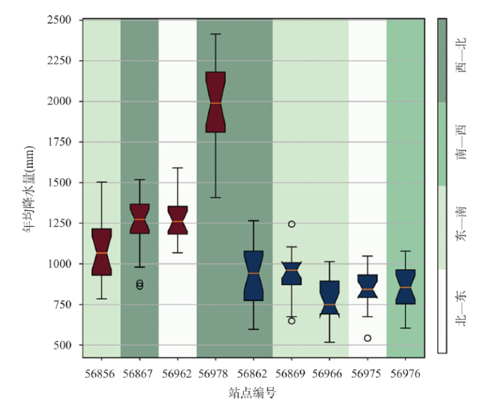
图4
2000—2018年元江流域干热河谷区哀牢山两侧观测站点平均降水量对比
注:图中位于哀牢山山脉西南侧的站点用红色标识,位于东北侧的站点用蓝色标识。
Fig. 4
Boxplot of average annual precipitation at meteorological observation stations on both sides of the Ailao Mountains in the dry hot valley area of the Yuanjiang River Basin from 2000 to 2018
3.2 基于MPRISMR算法的平均态日降水插值结果验证
本文计算并提取高程、坡向、大尺度地形起伏度、小尺度地形起伏度四个地形要素,随后遍历待插值点,根据权重计算公式对每一个待插值点形成观测站点权重集合。流域内23个站点上的综合权重赋值情况表明,综合权重能够识别出站点在大尺度和小尺度地形起伏上的差异。例如,当待插值点为位于河谷的站点56966时,部分位于河谷区的站点权重较大,证明综合权重具有区分不同站点所处小尺度地形起伏度的能力;位于平原地区的站点权重较小,证明综合权重具有区分不同站点所处大尺度地形起伏度的能力(图5)。基于综合权重集合,研究首先采取“留一法”,用MPRISMR算法计算了元江流域23个观测站点的平均态日降水,并根据观测站点观测值计算得到观测站点“留一法”平均态日降水插值结果的CC、RB(图6)。其中,CC在整个流域均达到0.92以上,但RB绝对值在下游处略大,表明在下游存在30%左右的低估,这是因为该流域下游一边为国界线,而观测站点仅限国界线以内。总体而言,具备高度可解释性的MPRISMR插值方法能够通过综合权重考虑复杂下垫面中的多种地形要素,这是其相比于其他插值方法的优势。
图5
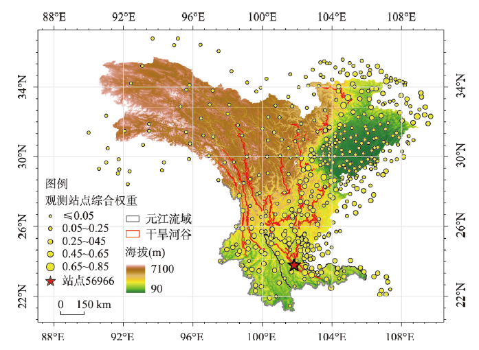
图5
元江流域待插值站点为位于河谷位置时(星型标注站点)其他观测站点综合权重赋值
Fig. 5
The assigned comprehensive weights of other observation stations when the station interpolation point (labelled with red star) to be interpolated is located in the valley in the Yuanjiang River Basin
图6

图6
基于MPRISMR算法的元江流域观测站点平均态日降水插值结果验证评价参数空间分布
Fig. 6
Spatial distributions of the verification evaluation index results of the mean daily precipitation interpolation results on observation stations in the Yuanjiang River Basin based on MPRISMR
3.3 基于MPRISMR算法的实际日降水插值结果验证
根据本文的MPRISMR算法流程,得到平均态日降水插值结果后,计算观测站点上实际日降水与平均态日降水插值结果的比值,然后,研究采用普通克里格方法对生成的比值再做空间插值,最终,研究采用插值后的平均态日降水与插值后的比值相乘,得到实际日降水的高空间分辨率插值结果。本文采用“留一法”对生成的元江流域内23个观测站点实际日降水结果进行验证,并与ERA5-Land、TRMM_3B42降水产品进行比对分析。结果表明,本文降水插值结果表现良好,其CC值在0.53到0.81之间,平均为0.71;RB绝对值的中位数为11%;NSE在12个站点上大于0.5,最低值为0.27;FSC平均值为0.78(表6)。Zhang等考虑坡向和高程改进角距加权算法,基于更密集的观测站点生成了1984—2012年黑河流域日降水插值数据,在验证阶段有11个站点的CC小于0.5(共33个站点)。相比之下,本文方法形成的降水插值结果在CC上更具稳定性[3]。各数据产品及插值结果验证评价指标的平均值和中位数表明,本文的降水插值结果优于ERA5-Land和TRMM_3B42降水产品。其中,ERA5-Land表现最差,其CC平均值为0.58,RB最高达到98%,FSC平均为0.66(图7)。此外,通过箱图的分散程度表征的各站点之间评价指标数值上的差异也体现了数据精度的稳定性,ERA5-Land和TRMM_3B42 两种全球降水产品在CC、MAE、RB上的最大最小值区间要小于本文的降水插值结果(图7),凸显了两种降水产品在大尺度稳定性上的优势,但其难以反应局部区域上的空间异质性。
表6 元江流域23个观测站点基于MPRISMR算法的“留一法”实际日降水插值结果及ERA5-Land、TRMM_3B42降水产品验证评价参数结果
Tab. 6
| 站点编号 | CC | RB(100%) | MAE(mm) | NSE | FSC | |||||||||||||
|---|---|---|---|---|---|---|---|---|---|---|---|---|---|---|---|---|---|---|
| MPRISMR | ERA5 | TRMM | MPRISMR | ERA5 | TRMM | MPRISMR | ERA5 | TRMM | MPRISMR | ERA5 | TRMM | MPRISMR | ERA5 | TRMM | ||||
| 56755 | 0.81 | 0.64 | 0.69 | 0.05 | 0.34 | 0.23 | 1.35 | 2.27 | 2.05 | 0.66 | 0.36 | 0.27 | 0.78 | 0.63 | 0.72 | |||
| 56756 | 0.78 | 0.56 | 0.69 | 0.03 | 0.23 | 0.18 | 1.46 | 2.69 | 2.09 | 0.61 | 0.34 | 0.29 | 0.75 | 0.63 | 0.69 | |||
| 56777 | 0.75 | 0.58 | 0.72 | -0.12 | 0.13 | -0.08 | 1.78 | 2.75 | 2.02 | 0.55 | 0.29 | 0.50 | 0.77 | 0.61 | 0.72 | |||
| 56851 | 0.74 | 0.60 | 0.66 | 0.29 | 0.69 | 0.26 | 1.75 | 3.29 | 2.09 | 0.52 | 0.17 | 0.13 | 0.73 | 0.71 | 0.69 | |||
| 56856 | 0.68 | 0.62 | 0.69 | -0.08 | 0.38 | 0.02 | 2.29 | 2.62 | 2.50 | 0.47 | 0.32 | 0.41 | 0.80 | 0.66 | 0.74 | |||
| 56862 | 0.74 | 0.57 | 0.70 | -0.02 | 0.21 | 0.03 | 1.89 | 4.17 | 2.13 | 0.55 | 0.36 | 0.41 | 0.76 | 0.70 | 0.70 | |||
| 56867 | 0.67 | 0.59 | 0.65 | -0.13 | 0.53 | -0.06 | 2.67 | 2.88 | 2.85 | 0.44 | 0.17 | 0.36 | 0.79 | 0.63 | 0.77 | |||
| 56869 | 0.74 | 0.57 | 0.65 | 0.08 | 0.37 | 0.05 | 1.94 | 2.77 | 2.29 | 0.53 | 0.23 | 0.30 | 0.77 | 0.60 | 0.73 | |||
| 56870 | 0.74 | 0.58 | 0.67 | 0.02 | 0.47 | 0.10 | 1.62 | 4.11 | 1.99 | 0.54 | 0.24 | 0.35 | 0.75 | 0.69 | 0.72 | |||
| 56961 | 0.71 | 0.56 | 0.58 | 0.08 | 0.40 | -0.09 | 3.10 | 3.37 | 3.60 | 0.49 | 0.25 | 0.23 | 0.82 | 0.58 | 0.76 | |||
| 56962 | 0.70 | 0.59 | 0.64 | -0.12 | 0.48 | -0.07 | 2.60 | 3.37 | 2.95 | 0.48 | 0.16 | 0.31 | 0.81 | 0.60 | 0.77 | |||
| 56966 | 0.70 | 0.55 | 0.69 | 0.34 | 0.91 | 0.31 | 2.09 | 3.00 | 2.24 | 0.47 | 0.06 | 0.30 | 0.73 | 0.58 | 0.72 | |||
| 56975 | 0.75 | 0.56 | 0.67 | 0.37 | 0.82 | 0.19 | 2.11 | 5.59 | 2.29 | 0.52 | 0.13 | 0.27 | 0.76 | 0.75 | 0.71 | |||
| 56976 | 0.72 | 0.57 | 0.64 | 0.52 | 0.47 | 0.40 | 2.40 | 5.43 | 2.62 | 0.42 | 0.14 | 0.03 | 0.73 | 0.74 | 0.72 | |||
| 56977 | 0.62 | 0.56 | 0.69 | -0.33 | 0.08 | -0.10 | 4.44 | 5.62 | 4.50 | 0.36 | 0.29 | 0.42 | 0.84 | 0.75 | 0.81 | |||
| 56978 | 0.69 | 0.56 | 0.64 | -0.35 | 0.20 | -0.38 | 3.65 | 3.46 | 4.10 | 0.44 | 0.27 | 0.37 | 0.86 | 0.68 | 0.75 | |||
| 56986 | 0.69 | 0.58 | 0.62 | 0.01 | -0.14 | 0.05 | 3.23 | 2.79 | 3.93 | 0.46 | 0.29 | 0.14 | 0.81 | 0.63 | 0.66 | |||
| 56987 | 0.65 | 0.60 | 0.63 | -0.38 | -0.05 | -0.28 | 4.56 | 3.73 | 4.82 | 0.38 | 0.30 | 0.35 | 0.84 | 0.69 | 0.74 | |||
| 56989 | 0.53 | 0.55 | 0.60 | -0.18 | 0.14 | 0.10 | 4.40 | 3.96 | 4.66 | 0.27 | 0.24 | 0.23 | 0.73 | 0.76 | 0.71 | |||
| 56992 | 0.72 | 0.62 | 0.61 | -0.07 | 0.14 | 0.01 | 2.38 | 2.16 | 3.10 | 0.52 | 0.27 | 0.22 | 0.80 | 0.63 | 0.64 | |||
| 56994 | 0.75 | 0.58 | 0.61 | 0.14 | 0.12 | 0.19 | 2.08 | 4.45 | 2.86 | 0.56 | 0.29 | 0.07 | 0.76 | 0.71 | 0.68 | |||
| 56995 | 0.71 | 0.51 | 0.61 | -0.05 | 0.24 | 0.03 | 2.56 | 5.36 | 3.38 | 0.51 | 0.26 | 0.19 | 0.80 | 0.66 | 0.64 | |||
| 56996 | 0.76 | 0.59 | 0.66 | 0.27 | 0.58 | 0.34 | 2.31 | 3.69 | 2.95 | 0.52 | 0.11 | 0.05 | 0.77 | 0.63 | 0.68 | |||
| 最大值 | 0.81 | 0.64 | 0.72 | 0.52 | 0.91 | 0.40 | 4.56 | 5.62 | 4.82 | 0.66 | 0.36 | 0.50 | 0.86 | 0.76 | 0.81 | |||
| 最小值 | 0.53 | 0.51 | 0.58 | -0.38 | -0.14 | -0.38 | 1.35 | 2.16 | 1.99 | 0.27 | 0.06 | 0.03 | 0.73 | 0.58 | 0.64 | |||
| 平均值 | 0.71 | 0.58 | 0.65 | 0.02 | 0.34 | 0.06 | 2.55 | 3.63 | 2.96 | 0.49 | 0.24 | 0.27 | 0.78 | 0.66 | 0.72 | |||
图7
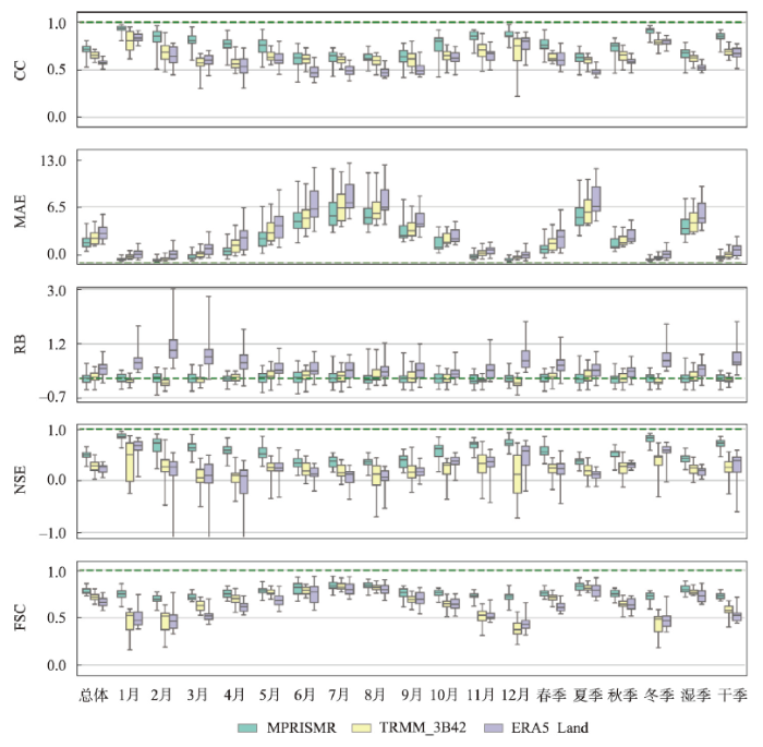
图7
元江流域23个站点基于MPRISMR算法的“留一法”实际日降水插值结果验证评价参数结果与ERA5-Land、TRMM_3B42降水产品验证评价参数结果的不同时期统计箱图
Fig. 7
Statistical boxplots of evaluation and verification index results of actual daily precipitation interpolation results based on MPRISMR and "leave-one-out" method, and precipitation products of ERA5-Land and TRMM_3B42 by month and season over 23 stations in the Yuanjiang River Basin
此外,为探究本文实际日降水插值结果在不同时期的表现,进一步绘制了23个站点3种日降水产品在12个月、4个季节、干季(11月至次年4月)与湿季(5月至10月)的评价指标统计箱图。结果表明,本文实际日降水插值结果的验证评价指标中位数在所有时间段上均优于其他两种产品;箱图的箱体长度即上下四分位数范围,除5—6月份的CC指标外,MPRISMR日降水插值结果的箱体长度最小,表明插值结果的评价指标在至少半数站点上分布区间较TRMM_3B42产品更集中,插值结果精度随空间变化更小,更为稳定;在箱图分散程度上,TRMM_3B42在CC、MAE及RB的表现较插值结果略优,表明考虑所有站点时,插值结果的这3种评价指标存在一定极端值;3种产品中,ERA5-Land在各时期综合表现均为最差。具体而言,3种产品在各评价指标上均显示出不同程度的时间性,其中,在CC、MAE、NSE指标上能观察到明显的伴随降水增多而精度减小的现象。MPRISMR插值结果的CC、NSE平均值在各月间范围分别为0.63(6月)~0.93(1月)、0.35(6月)~0.85(1月),在各季节间范围分别为0.62(夏季)~0.9(冬季)、0.34(夏季)~0.8(冬季),相较而言,MPRISMR插值结果的精度随时间变化的变幅最小,更为稳定;MPRISMR日降水插值结果的RB随时间变化不明显,但在降水较多的时段RB值箱图分散程度也相对较大,表明随着降水增多,方法准确性在各站点间的差异均更为显著;与CC、MAE、NSE相反,FSC指标随降水量增多而增大,3种产品正确预测降水事件发生的频率升高;同时,在降水较少的冬季(11月至次年1月),MPRISMR插值方法的优势尤为显著,FSC平均为0.72,而ERA5-Land和TRMM_3B42仅有0.47和0.43。
3.4 元江流域高分辨率格网数据
用“留一法”交叉验证对MPRISMR插值方法进行检验后,本文基于2000—2018年干旱河谷区所在流域内及周边458个气象观测站点日尺度降水观测数据,插值生成了覆盖元江流域的2000—2018年日降水格网数据,其空间分辨率约为3 km(0.027°)。基于该套空间插值数据产品,进一步制备了2000—2018年4个季节平均降水量及多年平均降水量的栅格数据(图8)。从插值结果来看,本文提出的MPRISMR插值方法很好地保留了观测数据的准确性。从时间规律上看,元江流域降水集中于夏季,秋季次之。从空间特征上看,元江流域降水量整体上自上游向下游递减,自山脊向河谷递减,干热空气在河谷中的局部环流及其在河谷东北侧的散溢使哀牢山东北侧降水与西南侧形成明显差异,夏秋季节降水量由哀牢山西南向东北方递减。此外,本文生成的数据产品较好的反映了干热河谷西南侧的哀牢山顶部降水大的特征,与前人研究相符[44],而其他两个数据产品难以捕捉,进一步表明本文方法生成的高分辨率降水信息的可靠性。
图8
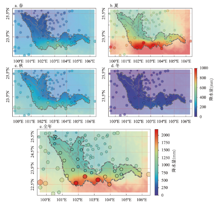
图8
基于MPRISMR算法生成的2000—2018年元江流域春、夏、秋、冬及年降水量空间分布
Fig. 8
Spatial distribution of spring, summer, autumn, winter and annual average precipitation that generated based on MPRISMR in the Yuanjiang River Basin from 2000 to 2018
4 讨论与结论
4.1 讨论
复杂地形山区占据中国陆域面积的65%以上。作为流域淡水的重要来源,其水资源的可持续管理对流域水文安全、生态建设、经济发展等关键环节有着重要意义。陆面过程模型是辅助研究水资源组分演变、农业灾害等重要问题的主要工具,降水作为气候及水循环系统的重要组成部分,是陆面过程模型最重要驱动参数之一[45-46]。降水数据的精度和分辨率直接影响模型模拟结果,进而影响科学决策。中国西南干热河谷区作为复杂地形地区的典型代表,其降水分配存在明显的空间异质性,这种异质性也影响了该地的植被覆盖、河川径流、人口分布等重要自然与人文要素分布[25,28,40,47]。缺乏能够捕捉到降水空间特征及时间规律的降水产品的背景下,该地区高空间分辨率降水资料的制备成为开展陆表过程模拟,进而实现科学管理决策工作的基础。本文通过解析和提取影响复杂地形降水分布的地形要素,对PRISM算法进行了改进。改进前的PRISM算法使用有效地形高度同时表征两种尺度的地形起伏度,且在提取时需要对备选半径数集进行逐一的测试,并通过主观判断确定所选半径的合理性。这在一定程度上可能由于参数选取不恰当导致基于PRISM算法的降水插值结果相对较差。因此,本文未对改进前与改进后PRISM算法中的观测站点的权重分配进行比较,而将结果验证的重点转向插值结果与观测资料替代性栅格数据产品的对比上。此外,对PRISM的应用更应该将其作为一个方法框架而非固定的模型,应在充分了解研究区影响降水规律与地形特征的基础上,适当选取地形要素和自定义参数。因此,本文针对地形要素提取时的搜索半径在流域尺度上可以通过先验知识进行判断这一点,对原PRISM进行了相应改进,改进后的方法更适用于流域尺度的高分辨率降水插值,而在更大尺度上很难用一套固定的参数描述复杂地形地貌特征。
近年来,随着降水空间观测任务的深入和气候模型的发展,基于观测站点校正遥感、大气再分析降水空间栅格产品成为降水数据研究的热点。多数研究以机器学习为主要工具,其中基于时间循环神经网络,如长短时记忆网络的深度学习框架能够一定程度上模拟出降水偏差的时序变化规律[48]。但是,当面对流域尺度模型的应用需求,机器学习方法耗时长、过程复杂,对计算设备、人员专业性上都有着较高的要求,生成数据的空间分辨率也受制于输入产品,在使用便捷性、过程可解释性、方法适用范围上都不如插值方法。与之存在类似问题的还有基于模式模型的数值模拟,该类方法借助于全球或局部气候模式模拟及预报天气情况,具有分辨率可变、能够充分考虑降水形成物理机制等优点,但是对于对降水产品的需求仅限于简单应用的跨学科研究人员来说,使用的学习成本要远高于插值方法。
4.2 结论
本文通过将地形要素提取环节改进后的PRISM算法嵌入到“平均态日降水—比值”插值框架,整体形成了MPRISMR算法。在复杂地形影响下降水空间分布呈现异质性的典型地区——元江干热河谷所在的元江流域上,用“留一法”结合相应位置的大气再分析和遥感降水资料验证了MPRISMR算法进行降水插值的可靠性,并最终制备生成了2000—2018年元江流域约3 km分辨率的日降水栅格数据产品。“留一法”验证MPRISMR算法的精度结果显示,本文结果优于ERA5-Land和TRMM_3B42日降水产品,与元江流域23个气象站点观测的实际日降水量的相关系数、相对偏差、平均绝对误差与纳什效率系数的中位数分别为0.72、0.98%、2.31mm、0.51;在对降水事件发生的预报上,采用的综合性验证评价指标FSC中位数为0.77。MPRISMR实际日降水插值结果的验证评价指标中位数在所有时间段上均优于其他两种产品,且精度随时间变化的变幅最小,更为稳定。3种数据在湿季的插值精度均要差于干季,因此在日后的降水产品校正等相关研究中应该重点关注降水量大的时间段的数据分析。基于MPRISMR算法生成的覆盖元江流域的日降水栅格数据计算的2000—2018年季节及年平均产品能够保留观测数据的准确性,同时能够捕捉到低分辨率产品无法识别的降水局部变化特征,进一步表明其可行性及生成的数据产品的准确性。本文提出的MPRISMR插值算法在原PRISM的基础上提升了对中小尺度地貌的刻画能力以及对具有随机噪声的日尺度降水数据的处理能力,适用于观测站点稀疏且地表起伏剧烈地区的流域降水数据空间插值工作。研究为元江干热河谷区提供了高分辨率日降水数据,能够服务于国际河流上游水资源综合管理,协助缓解和预防极端气候条件下旱涝灾害风险,提升流域可持续管理决策分析能力。
参考文献
Spatio-temporal variations of precipitation and runoff and analyses of water-heat-human-land matching characteristics in typical mountainous areas of China
DOI:10.11821/dlxb201911007
[本文引用: 1]

Mountainous areas in China face complex problems due to conflicts between natural eco-environmental protection and socio-economic development. Mountain water resources have evolved in the context of climate change and human activities, which further affects their coordination and matching with regional climate resources, land resources and socio-economy. Hence, it is of fundamental significance for mountain development to study these issues to identify key weakness and provide solutions. The paper focuses on three typical mountainous areas under different natural geographic conditions and at socio-economic development levels in China, namely, Taihang Mountains Area (TMA), Hengduan Mountains Region (HMR) and Guizhou-Guangxi Karst Area (GKA), and studies the spatio-temporal variations of precipitation and runoff from 1956 to 2015 by Mann-Kendall test based on national water resources assessment results and statistical data of land use and socio-economy. The characteristics of natural and socio-economic factors are analyzed by matching distance and imbalance index. In this process, four groups of parameters are selected, including water (precipitation and runoff), heat (accumulated temperature and radiation), land (total area and farmland area) and socio-economy (population and GDP). The results indicate that, the water resources endowment of TMA is the worst, and significant reduction of runoff since 2000 makes it even worse, while the precipitation and runoff of HMR and GKA are abundant and there is no obvious change trend. According to the analysis of regional water-heat-human-land matching characteristics, TMA mainly suffers from water shortage, land and heat resources have great disadvantages in most parts of HMR with uneven distribution of water and heat, and land resources are relatively deficient in all counties of GKA. In general, mismatching degree of water and other factors is the highest, and the allocation and coordination of water are the key issue for sustainable development of mountainous areas, especially in TMA.
典型山地降水径流时空演变及“水—热—人—地”匹配性分析
DOI:10.11821/dlxb201911007
[本文引用: 1]
山地是中国自然生态保护与经济社会发展问题交织、矛盾突出的区域。山地水资源受气候变化和人类活动综合影响发生演变,进一步影响到其与区域气候资源、土地资源以及经济社会之间的协调匹配,研究这些问题对辨识山地发展关键短板、提供山地问题解决思路具有基础意义。根据自然环境特点和经济社会发展状况,选择太行山、横断山和黔桂喀斯特三大典型山地开展研究,基于全国水资源调查评价成果及土地利用、经济社会数据,采用Mann-Kendall检验等方法分析1956-2015年山地降水和径流时空演变特点;采用匹配距离和不平衡指数对山地的水(降水和径流)、热(积温和辐射)、地(面积和耕地)以及社会经济(人口和GDP)等4类要素匹配性进行综合对比分析。结果表明:三大典型山地中,太行山水资源禀赋最差,且2000年以来径流显著衰减,而横断山和黔桂喀斯特降水、径流丰富,且无明显变化趋势;从“水—热—人—地”对比来看,太行山以缺水问题为主,横断山多数地区土地与热资源偏少且水热空间差异大,黔桂喀斯特整体来说土地资源偏少;综合来看,水与其他要素的匹配性最差,特别是在太行山区,水的时空分布及其均衡匹配是保障山地可持续发展的关键。
Fine-resolution precipitation mapping over Syria using local regression and spatial interpolation
Spatial interpolation of daily precipitation based on modified ADW method for gauge-scarce mountainous regions: A case study in the Shiyang River Basin
Hydrological evaluation of open-access precipitation and air temperature datasets using SWAT in a poorly gauged basin in Ethiopia
DOI:10.1016/j.jhydrol.2018.12.026 URL [本文引用: 1]
Validation of CHIRPS precipitation dataset along the Central Andes of Argentina
DOI:10.1016/j.atmosres.2018.06.023 URL [本文引用: 1]
The climate hazards infrared precipitation with stations: A new environmental record for monitoring extremes
Spatial interpolation of daily totals of rainfall
DOI:10.1016/0022-1694(78)90037-9 URL [本文引用: 1]
Precipitation average for large areas
Estimation models for precipitation in mountainous regions: The use of GIS and multivariate analysis
DOI:10.1016/S0022-1694(02)00110-5 URL [本文引用: 1]
A comparison of geostatistical procedures for spatial analysis of precipitation in mountainous terrain
DOI:10.1016/0168-1923(92)90114-J URL [本文引用: 1]
Precipitation estimation in mountainous terrain using multivariate geostatistics (Part I): Structural analysis
An ensemble version of the E-OBS temperature and precipitation data sets
DOI:10.1029/2017JD028200 URL [本文引用: 1]
TIER version 1.0: An open-source Topographically InformEd Regression (TIER) model to estimate spatial meteorological fields
DOI:10.5194/gmd-13-1827-2020 URL [本文引用: 2]
A statistical-topographic model for mapping climatological precipitation over mountainous terrain
Physiographically sensitive mapping of climatological temperature and precipitation across the conterminous United States
DOI:10.1002/joc.1688 URL [本文引用: 5]
Evaluation of terrain-considered spatial interpolation methods on temperature and precipitation in complex underlying surface region
考虑地形的空间插值算法在复杂下垫面地区气温和降水精细化插值的评估
Stacking machine learning models versus a locally weighted linear model to generate high-resolution monthly precipitation over a topographically complex area
Validation of simulated grid data sets of China's temperature and precipitation with high spatial resolution
中国高分辨率温度和降水模拟数据的验证
Precipitation trends determine future occurrences of compound hot-dry events
DOI:10.1038/s41558-022-01309-5 URL [本文引用: 1]
Climate Change 2021:The Physical Science Basis
Agriculture and climate change are reshaping insect biodiversity worldwide
DOI:10.1038/s41586-022-04644-x URL [本文引用: 1]
Geographical studies of Southwest China based on articles published in Acta Geographica Sinica from 1934 to 2018
DOI:10.11821/dlxb201911004
[本文引用: 1]
Regions continue to be one of the most logical and satisfactory ways of organizing the geographical information. Southwest China has always been concerned by geographers at home and abroad for its unique geographical phenomena. Its research vein could be looked into and given some useful suggestions for the future research through analyses of the articles published in Acta Geographica Sinica during 1934-2018. The results show that: (1) Articles about Southwest China covered almost all the subjects of geography, and the research results about geomorphology, meteorological climate, integrated physical geography, and ecological environment are the most widely published, while those on cities, ethnic groups, transportation and health are less concerned; (2) Up to 2018, the research had experienced four stages, early traditional regional research, task-led discipline, connecting the preceding and the following, and diversified development; (3) The periodical changes of the quantity and contents of these articles are influenced by the pattern of national affairs, and by the changes of the research paradigm of geography; (4) The articles published in Acta Geographica Sinica are of high research level, no matter from the academic perspective or the research methods, and many studies on regional nature, humanities, social economy and ecological environment are at the forefront of academic research, representing the academic research on geography of Southwest China; (5) However, the growth rate of articles about this region is far behind the increase in the number of articles in Acta Geographica Sinica, and the external research institutions and universities account for a large proportion of the number of articles, while the locals are weak. Compared with physical geography, there are fewer studies on human geography. As China's "island in the sky" and "cradle of ancient humans beings", Southwest China should be re-examined in the fields of the traditional and modern collision, boundary contact and conflict, and inter-regional contact and competition from the perspective of new regional geography, and continue to achieve the geographical significance of the study region.
基于《地理学报》创刊85年载文的中国西南地区之地理研究
DOI:10.11821/dlxb201911004
[本文引用: 1]
西南地区以其独特的地理现象一直为国内外地理学者所关注。通过对《地理学报》创刊以来85年间西南地区研究的载文分析,可以管窥其研究脉络,并予未来研究以启示。结果表明:① 232篇论文囊括了地理研究的若干主题,但以地貌、气象气候、综合自然地理和生态环境发文量最大,而城市、民族、交通、健康则关注较少;② 研究经历了传统区域研究、任务带学科、承上启下和多元化发展4个阶段;③ 论文在数量和内容上的阶段性变化,既受国家时事格局影响,也受地理学科研究范式发展变化影响;④ 《地理学报》有关西南地区的载文具有很高的研究水平,无论是在学术视野还是研究方法手段上,区域的自然、人文、社会经济与生态环境等诸多研究都站在了学术研究前沿,代表了学界对西南地理的研究情况;⑤ 但西南地理研究论文增长速度远赶不上《地理学报》载文量增长,外来研究机构占比很大,本土力量弱;相较自然地理,人文地理研究也少而弱。可见,西南地理研究当从新区域地理视角重新审视这一地区传统与现代的碰撞、边界的接触与冲突和区际的联系与竞争,继续成就西南地区重要的地理意义。
Climate change of the longitudinal range-gorge in Yunnan and its influence on the river flow
DOI:10.11821/xb200501011
[本文引用: 2]
Based on the observed data of the flow in the longitudinal range-gorge region and the data of monthly precipitation and air temperature field in Yunnan, and using the statistics and wavelet transforms, the interannual climate change under the effect of the longitudinal range-gorge and its influence on the international river flows are investigated. The results show that the latitude variations of the high correlation centers between the monthly precipitation field and the international river flows are not significant due to the role of special underlying surface in the longitudinal range-gorge region, but the longitude variations are very significant. The annual precipitation of the Lancang climatic region is obviously greater than that of the eastern Lixian River and Yuan River regions, but the standard deviation of the annual precipitation is significantly smaller than them. The annual mean air temperature of the Yuan River region is lower than that of the western Lixian River and Lancang River regions, and the standard deviation of the annual air temperature is also smaller than them. Corresponding to the characteristics of the annual precipitation variations under the effect of the longitudinal range-gorge, the standard deviation of the annual flows of the Yuan River is also obviously greater than western Lixian and Lancang rivers. The barrier action of longitudinal range-gorge on southwest monsoon is greater, but on northeast monsoon is smaller. The annual precipitation variations under the effect of the longitudinal range-gorge are mainly on the smaller time scale, with the increase of time scale, the effect of the longitudinal range-gorge becomes smaller. The role of the longitudinal range-gorge in the annual air temperature variations is smaller than the annual precipitation variations. In recent years, the main characteristics of the annual precipitation variations in all the climatic regions are that precipitation tends to increase, under such an effect, the annual flow variations for the international rivers also tend to be great.
云南纵向岭谷地区气候变化对河流径流量的影响
Spatio-temporal variations of temperature and precipitation in Mts. Hengduan region during 1960-2008
DOI:10.11821/xb201005006
[本文引用: 1]
Based on daily temperature and precipitation data of 27 stations in the Mts. Hengduan region, methods of spline interpolation, regression analysis, least square, moving average were employed to analyze the climatic changing trend and spatial differences under the background of global warming. Results indicated that temperature patterns are consistent with warming at statistical significance level during 1960-2008, and relatively low in the 1960s and 1980s, whereas it started to rise after the 1980s which can be proved by a 0.46 oC temperature increase in 2000-2008. The average temperature of all the year, spring, summer, autumn and winter exhibited an obvious increasing trend roughly centered in the area of Mt. Meili and the southernmost between Mt. Shaluli and Mt. Daxue with the velocity of 0.15 oC 10a-1, 0.589 oC 10a-1, 0.153 oC 10a-1, 0.167 oC 10a-1 and 0.347 oC 10a-1, respectively. And what\'s more, temperature increase is more obvious from lower to higher altitude. Precipitation is relatively more after the 1980s, which can be confirmed by a 29.84 mm increase in the 1990s, but it started to decrease after 2000. The average precipitation of all the year, spring, summer, autumn and winter changed by 9.09 mm 10a-1, 8.62 mm 10a-1,-1.5 mm 10a-1, 1.53 mm 10a-1 and 1.47 mm 10a-1, respectively, roughly centered in the area of Mt. Meili and the southernmost between Mt. Shaluli and Mt. Daxue, and only the spring is significant at the 0.05 level. Under the influence of the longitudinal range-gorge, the regional trend in precipitation was on the decrease from southwest to northeast and from south to north in the Mts. Hengduan region. In summer monsoon, the regional trends of temperature and precipitation are 0.117 oC 10a-1 and 6.01 mm 10a-1, respectively, but the precipitation also started to decrease after 2000. There is also a 0.25 oC 10a-1 and 7.47 mm 10a-1 increase of temperature and precipitation in winter monsoon.
我国横断山区1960—2008年气温和降水时空变化特征
Regional variation of annual precipitation along the tropic of cancer in longitudinal range-gorge region
DOI:10.11821/xb201003003
[本文引用: 1]
<p>Through using monthly precipitation data of 24 meteorological stations near the Tropic of Cancer in southern Longitudinal Range-Gorge Region (LRGR) covering the period 1961-2007, this study first analyzed the main characteristics of annual precipitation at each station. Secondly, it tested the changing trend and phases of annual precipitation at 9 stations along the Tropic of Caner in the study area. Then it calculated the correlation coefficients of annual precipitation series and monthly (May to October) precipitation series between stations along the Tropic of Cancer. The results showed that in the study area, annual precipitation and its inter-annual changes are characterized by certain regional variations. On this basis, three zones are identified, i.e., western part, central part and eastern part. High similarity was found in each of the three parts and obvious variation was observed among them. Annual precipitation series at each station along the Tropic of Cancer within the study area did not present obvious “abrupt trends-phases” changes. Range-gorge landforms within the central part of the study area have certain influences upon the spatial variation of precipitation, while high correlation coefficients of annual and monthly precipitation occurred between the neighbouring stations, especially on the two sides of the Ailao Mountain within the central part, indicating that there were no obvious differences for the precipitation-driving factors in the central part. Regional inter-distributed range-gorge landforms are likely to cause local variations of precipitation.</p>
纵向岭谷区北回归线一带年降水区域分异特征
Variations of agricultural water requirements in Lancang river basin in last 50 years
DOI:10.11821/xb201011005
[本文引用: 2]
Weather data of 8 meteorologic stations in the Lancang River Basin from the 1950s to 2007 and current cropping pattern, field water moisture management, etc., were collected and used to investigate changes in humidity and crop irrigation water requirements using Mann-Kendall and the Rescaled Range Analysis methods. The results show that in the whole basin, annual and dry-season average temperatures significantly increased, and dry-season rainfall increased while wet-season rainfall decreased. Evaportranspiration (ET0) increased during both dry and wet seasons at all the stations except Dali, Jianchuan and Gengma, and the aridity-humidity index decreased at most stations. The turning points of weather factors, ET0, the aridity-humidity index, paddy irrigation requirements and total agricultural water requirements occurred from the 1960s to the 1990s. The spatial changing tendency of paddy irrigation quota increased with the increase of altitude and latitude, and the coorelation coefficients are 0.513 and 0.610, respectively. The maximum value inWeixi, while the minimum in Mengla.
近50多年来澜沧江流域农业灌溉需水的时空变化
DOI:10.11821/xb201011005
[本文引用: 2]
利用澜沧江流域云南境内8 个气象站1950s-2007 年的逐月气象数据,现状作物种植、农业耕作、田间水分管理等资料,应用Mann-Kendall 法和R/S 分析法,探索50 多年来流域区的干湿变化、农业灌溉定额转折变化趋势及分布规律。结果表明:年、季平均温度普遍地显著升高,降水量干季增加、湿季减少;大部分地区的参照作物腾发量ET0在年度及干、湿季都呈增加趋势,仅在流域中段大理、剑川、耿马的部分时段为减少,干湿指数大多数地区都是降低;水稻及农业综合灌溉需水定额从流域上游到下游逐渐呈减少、增-减并存到增加的趋势。气象因子、ET0、干湿指数、水稻灌溉及农业综合灌溉定额发生转折变异现象都集中在澜沧江中下段的耿马、思茅、景洪、勐腊等地,且时间系列的转折变异点在1960s-1990s 的各个时期均有出现。水稻灌溉定额随纬度方向变化的相关系数为0.513,随海拔高程变化为0.610,最高值出现在维西,最低值为勐腊;农业综合灌溉定额受作物种植结构和水稻种植面积的影响较大,二者相关系数达到0.826,但其与纬度、海拔的变化规律不明显,最高值在大理,最低值在维西。灌溉定额在小范围内的多样性变化,表明在纵向岭谷特殊环境对地表水汽输送、气温和气流场分布等的“通道-阻隔”作用下,澜沧江河谷农业灌溉需水量时空变化的复杂性。
Distribution scope and district statistical analysis of dry valleys in southwest China
西南地区干旱河谷分布范围及分区统计分析
ERA5-Land hourly data from 1981 to present
ERA5-Land hourly data from 1950 to 1980
TRMM (TMPA) Precipitation L 3 1 day 0.25 degree × 0.25 degree V7
Hydrological performance of ERA5 and MERRA-2 precipitation products over the Great Lakes basin
Assessment of global reanalysis precipitation for hydrological modelling in data-scarce regions: A case study of Kenya
Assessment of GPM and TRMM multi-satellite precipitation products in streamflow simulations in a data-sparse mountainous watershed in Myanmar
Applications of TRMM-and GPM-era multiple-satellite precipitation products for flood simulations at sub-daily scales in a sparsely gauged watershed in Myanmar
Representing twentieth-century space-time climate variability. Part II: Development of
DOI:10.1175/1520-0442(2000)013<2217:RTCSTC>2.0.CO;2 URL [本文引用: 1]
New discussion on dry valley formation in the Three Parallel Rivers Region
三江并流区干热河谷成因新探析
Barrier-corridor effect of longitudinal range-gorge terrain on monsoons in Southwest China
DOI:10.11821/yj2012010001
[本文引用: 2]
Topographic pattern has important impacts on atmospheric circulation and regional climate.The special terrain of Longitudinal Range-Gorge Region(LRGR) in Southwest China has a "corridor-barrier" effect on monsoons circulation,which led to the redistribution of surface hydrothermal pattern and is the main driving force of the formation and evolution of the ecosystems.Previous studies showed that LRGR was influenced by the combined effect of the Indian monsoon and the Pacific monsoon,which meet at the Ailaoshan mountain ranges.The Ailao Mountains are an important geographical dividing line.In this study,based on proofs of the atmospheric circulation,moisture transport,regional climate,runoff,and plant stable oxygen isotopes compostion,we found that LRGR is affected mainly by the Indian monsoon.The Pacific monsoon only affect this area in August,and the influence is not significant.Under the terrain "corridor-barrier" effect,surface water vapor,precipitation and runoff in LRGR showed significant zonal differences and meridional extension;crowd circulation,moisture transport,regional climate and river runoff.The atmospheric precipitable water,precipitation and stream flow present an apparently different pattern between the west and east sides of Ailao Mountains.The environmental differences are the results of the hydrothermal redistribution by the special terrain,which are the "barrier" and "corridor" effects of the LRGR.These differences are not the results of geographical zonality,but the results of non-zonality.The "corridor-barrier" effects of the longitudial range-gorge on monsoons result in the spatial differences of the geographical elements and the associated ecological effects.
西南纵向岭谷地形对季风的“通道—阻隔”作用
DOI:10.11821/yj2012010001
[本文引用: 2]
地形格局对大气环流与区域气候具有重要影响。已有研究认为纵向岭谷区主要受到印度洋季风与太平洋季风的共同影响,二者在哀牢山山脉附近交汇,哀牢山山脉是一条重要的地理分界线。本文从大气环流、水汽输送、区域气候、河川径流以及植物稳定氧同位素等多个方面研究发现:纵向岭谷地区主要受印度洋季风的影响,太平洋季风的影响在8月份有一定的作用,但不够明显;在地形格局作用下,地表水汽、降水以及河川径流在纵向岭谷区表现出明显的纬向差异、经向延伸的特征;大流环流、水汽输送、区域气候以及河川径流等的空间差异,是特殊环境对水热再分配的结果,即"通道-阻隔"作用的效应;这些差异不是地理地带性的表现,而是非地带性作用的结果;这种"通道—阻隔"作用导致地表水热条件的再分配,是该区生态地理格局形成与演化的主驱动力之一。纵向岭谷地形对季风的"通道—阻隔"作用导致了一系列地理要素的空间分异和相关联的生态效应。
Statistical downscaling for daily precipitation in Korea using combined PRISM, RCM, and quantile mapping: Part 1, methodology and evaluation in historical simulation
DOI:10.1007/s13143-016-0010-3 URL [本文引用: 1]
Improvement of daily precipitation estimations using PRISM with inverse-distance weighting
DOI:10.1007/s00704-019-03012-6 URL [本文引用: 1]
Spatial interpolation of daily precipitation in a high mountainous watershed based on gauge observations and a regional climate model simulation
DOI:10.1175/JHM-D-16-0089.1 URL [本文引用: 1]
Vertical distribution characteristics of rainfall in the AiLao Mountain
DOI:10.13249/j.cnki.sgs.1994.02.144
[本文引用: 1]
This paper discusses the vertical distributions of total rainfall, and cold and warm advection rainfall on the windward and leeward slopes in the northern part of the Ailao Mountains of Yunnan Province,China according to the climatological data of eight sta-tions:(1)There are 5% and 10% of annual rain days during the period of July to August with 25% and 40% of annual rainfall,which results in "rain disaster". Other 50% of an-nual rain days appear most frequently in dry season,but rain is only 9% of the total.(2)Rainfall increases with altitude. It is reduced by 38%-46% in the valley com-paring with the top area of mountain where it is more than 1800mm. Rainfall gradient normals is less greater.on the west slope than on the east one,of which it is greater in rainy season than in dry season. Rainfall variability is obviously decreased by a range of 313mm and 17% at the top to 132-200mm and 12%-14% in the valley.(3)The main peak of diurnal rainfall variation appears at about sunrise and the sec-ondary one in afternoon on the slopes,but it is contrary at the top. The night rainfall ra-tio is greater on the west slope with 51%-57% than on the east one with 44%-48%.(4)The warm advection(southwest monsoon)rainfall(WR)is 200-300mm on the windward(west)slope more than that on the leeward(east)slope,while the cold advec-tion(northeast monsoon)rainfall(CR)is 100-150mm on the windward(east)slope more than that on the leeward(west)one. The WR or CR gradient is the leeward larger than the windward in a whole year and rainy season,while it is opposite in dry season.
哀牢山降水垂直分布特征
Multi-source data quality assessment based on the index of runoff sensitivity to climate change
DOI:10.11821/dlxb202209010
[本文引用: 1]
Accurately assessing the sensitivity of runoff to climate change is critical for water resource management. In recent years, multi-source meteorological and hydrological datasets have been widely used in the analysis of runoff sensitivity to climate change, but no studies has evaluated different datasets from the perspective of runoff sensitivity. Based on the observed meteorological and hydrological data of six watersheds in China with different climatic conditions, the sensitivity of runoff to changes in precipitation and potential evapotranspiration were estimated. The sensitivity index was then used as the benchmark to evaluate the simulation capability of runoff sensitivity of 45 datasets in GLDAS (Global Land Data Assimilation System), ISIMIP2a (Inter-Sectoral Impact Model Intercomparison Project Phase 2a), ISIMIP2b, CMIP6 (Coupled Model Intercomparison Project Phase 6). The results showed that the simulation accuracy of the GLDAS dataset was low, and the simulation accuracies of CMIP6, ISIMIP2a, and ISIMIP2b datasets had little difference. For specific datasets, CLM4.0 in ISIMIP2a, UKESM1-0-LL and MIROC6 in CMIP6 had good runoff sensitivity simulation results in the six watersheds, and they can be applied to runoff sensitivity simulations under different climatic conditions. The results can provide reference for the predictions of runoff and water resources changes in watersheds with limited observation data under the influence of climate change.
基于径流对气候变化敏感性指标的多源数据质量评估
DOI:10.11821/dlxb202209010
[本文引用: 1]
准确评估径流对气候变化的敏感性对水资源管理至关重要。多源气象水文数据集已被广泛应用于径流对气候变化敏感性的分析中,但目前尚无研究从径流敏感性的角度评价不同数据集。基于中国6个不同气候条件流域的实测气象水文资料,本文计算了径流对降水和潜在蒸散发变化的敏感性,并以此为基准评估4类数据集GLDAS、ISIMIP2a、ISIMIP2b、CMIP6 共45套子数据集的径流敏感性模拟效果。结果表明:GLDAS数据集模拟精度较低,CMIP6、ISIMIP2a、ISIMIP2b数据集模拟精度差异较小;3套子数据集ISIMIP2a中的CLM4.0、CMIP6中的UKESM1-0-LL、MIROC6在6个流域均具有较好的径流敏感性模拟效果,可适用于不同气候条件下的径流敏感性模拟与演化趋势分析。本文研究结果可为气候变化影响下中国稀缺资料流域的径流和水资源变化预估提供参考。
Prediction of agricultural drought in China based on Meta-Gaussian model
DOI:10.11821/dlxb202103003
[本文引用: 1]
It is predicted that many regions will witness higher frequencies of drought events under global climate change, which could pose a threat to crop yield and water security. Therefore, the development of efficient and reliable methods for agricultural drought prediction is crucial. This study used the Standardized Precipitation Index (SPI) based on monthly precipitation at a 6-month time scale as an indicator of meteorological drought. The Joint Standardized Soil Moisture Index (JSSI) was used to assess the comprehensive situation of agricultural drought and was derived by combining the Standardized Soil Moisture Index (SSI) over 1-, 3-, 6-, 9-, and 12-month time scales based on monthly root zone soil moisture. Using the antecedent SPI and the persistent JSSI as predictors, the Meta-Gaussian (MG) model was applied to predict agricultural drought in China from June to August in 1961-2015. The Brier Skill Score (BSS) and Nash-Sutcliffe Efficiency Coefficient (NSE) were adopted for the evaluation of the prediction performance of the MG model. The results showed that the JSSI was capable of capturing both emerging and prolonged agricultural droughts in a timely manner, which is significant for agricultural drought monitoring. The spatial distribution of predictions of severe agricultural droughts with the 1- to 3-month lead by the JSSI for June to August in 2010 and 2014 resembled the corresponding observations for most parts of China. Moreover, the areas with a predicted higher probability of JSSI falling below -0.5 corresponded well with areas that experienced agricultural drought according to observed data (JSSI < -0.5). The BSS and NSE results confirmed that the MG model was able to provide reliable predictions of agricultural drought for June to August in most parts of China. The prediction of JSSI from June to August by the MG model with the 1-month lead showed that the proportions of the total area with BSS ≥ 0.5 were 0.714, 0.642, and 0.640, respectively, whereas the proportions of the total area with NSE ≥ 0.5 were 0.903, 0.829, and 0.837, respectively. However, the MG model performed poorly in desert areas, including southern Xinjiang, western Qinghai and western Inner Mongolia, which may have been due to the extremely arid conditions of these regions with soil water mostly related to condensation water rather than rainfall. The results of this study can provide scientific basis for agricultural drought monitoring, early warning, and decision-making in China.
基于Meta-Gaussian模型的中国农业干旱预测研究
DOI:10.11821/dlxb202103003
[本文引用: 1]
在全球气候变化背景下,干旱愈加频发,有效且可靠的农业干旱预测对于保障粮食安全和水资源安全具有重要意义。以标准化降水指数(SPI)和联合标准化土壤湿度指数(JSSI)分别表征气象干旱和农业干旱,以前期的气象干旱和农业干旱指数作为预测因子,在1~3个月预见期下基于Meta-Gaussian(MG)模型对中国1961—2015年6—8月的农业干旱进行预测,并采用Brier Skill Score(BSS)和纳什效率系数(NSE)评价MG模型的预测性能。结果表明:① 将1个月、3个月、6个月、9个月和12个月时间尺度的标准化土壤湿度指数(SSI)结合起来得到的JSSI能够对中国农业干旱的综合状况进行客观评价。② 以中国2010年和2014年遭受严重的干旱事件为例,预见期为1~3个月时,除新疆南部、青海西部以及内蒙古西部等沙漠地区外,MG模型对6—8月农业干旱预测结果的分布范围与实际干旱的分布区域较吻合,预见期越短,吻合越好。③ 预见期为1个月时,6—8月BSS ≥ 0.5的面积比例分别为0.714、0.642和0.640,NSE ≥ 0.5的面积比例分别为0.903、0.829和0.837,表明MG模型能够对中国大部分区域的农业干旱作出可靠的预测。本文结果可为中国农业干旱的监测、预警及干旱决策提供科学指导。
Ecological effects of longitudinal range-gorge land surface pattern and its regional differentiation
DOI:10.11821/xb201201002
[本文引用: 1]
The land surface pattern of Longitudinal Range-Gorge Region with towering mountains and deep valleys arranged vertically side by side has significant effects on physical environments and eco-geographical differentiation in Southwest China. Based on 1:50,000 DEM data, monthly meteorological and hydrological records, NDVI and NPP derived from MOD13 and MOD17, together with 1:1,000,000 vegetation types map, we select surface atmospheric water vapor content, precipitation, aridity/humidity index, and surface runoff as water indices; air temperature and accumulated temperature as temperature indices, and solar radiation as a heat index to study the hydrothermal pattern, regional differentiation of ecosystem structure and function and main influencing factors. The ANUSPLIN model, wavelet analysis, GIS spatial analysis and landscape pattern analysis were used to reveal the effects of land surface pattern on eco-geographical regional differentiation. Results show that the water, temperature and heat have significant differences along the latitudinal direction with intermittent difference and longitudinal direction with continuous extension, which reflects the special "corridor-barrier" effect of longitudinal range-gorge terrain, in which the vertical mountain and valleys on the surface of natural material and energy transport mainly showed significant north-south corridor and diffusion effects and the role of east-west barrier and barrier effect. The longitudinal range-gorge terrain also have important impacts on the spatial pattern of vegetation landscape diversity, ecosystem structure and function, which is the main influencing factor affecing the spatial distribution of vegetation landscape diversity and ecosystems pattern. Wavelet variance analysis reflects the spatial anisotropy of environmental factors as well as NDVI and NPP. The wavelet coherence reveals the spatial distribution of NDVI and NPP influencing factors, and also the quantitative degree of control. Conclusions believe that the longitudinal range-gorge land surface pattern is the main influencing factor of the eco-geographical elements. Under the interaction of the zonality law and the non-zonality "corridor-barrier" effects, the spatial differentiation formed in the eco-geographical system.
纵向岭谷区地表格局的生态效应及其区域分异
DOI:10.11821/xb201201002
[本文引用: 1]
中国西南纵向高耸山岭与深切河谷并列排布的特殊地表格局对该区自然环境与生态地理区域分异的效应明显。利用纵向岭谷区1:5 万DEM数据、建站以来至2010 的气象观测数据、水文观测资料、MOD13 与MOD17 的NDVI与NPP产品以及1:100 万植被类型数据等,选取地表大气水汽含量、降水量、干湿指数、地表径流等水分指标,平均气温、年积温等温度指标以及太阳总辐射等热量指标,基于ANUSPLIN样条函数、GIS空间分析、小波分析、景观格局分析等方法,分析该区水热格局、生态系统结构与功能的地域分异特征及其主控因子,揭示地表格局对生态地理要素区域分异的效应。结果表明:受地表格局的影响,纵向岭谷区的水分、温度与热量都表现出明显的沿纬线方向间断式差异和经线方向连续式延伸的分布特征,纵向山系与河谷对地表主要自然物质和能量输送具有南北向通道作用和扩散效应以及东西向阻隔作用和屏障效应;特殊地表格局对植被景观多样性、生态系统结构与功能的空间格局产生重要影响,是植被景观多样性与生态系统空间分布的主要控制因子;小波方差分析反映了环境因子以及NDVI、NPP的空间各向异性,而小波一致性分析揭示了NDVI与NPP空间分布的控制因子,及其控制程度的定量关系。纵向岭谷特殊地表格局是该区生态地理区域分异的主要影响因素,在地带性规律与以“通道—阻隔”作用为主要特征的非地带性规律共同作用下,形成了纵向岭谷区生态地理区域系统的特殊空间特征。
Correcting the bias of daily satellite precipitation estimates in tropical regions using deep neural network
