

1 引言
径流如何响应气候变化是水循环研究的重要内容,直接影响到未来水资源可利用量的变化预估[10⇓⇓⇓-14]。径流对气候变化的敏感性是反映这一响应的重要指标,是指“气候变化下径流影响因素一定比例的变化导致径流变化的比例”[15⇓⇓-18]。如Beighuijs等基于全球水文模型WATCH数据集发现,中国大部分地区降水变化10%导致径流变化50%以上[11];Zhang等基于CMIP5数据集发现,中国大部分地区降水变化10%仅导致径流变化10%~40%[19]。不同数据集对于同一地区径流对气候变化敏感性的刻画往往不一致,这会导致这一地区未来水资源变化预估的不确定性。遗憾的是,尽管存在大量研究基于各种数据集来分析径流敏感性,但仅有少量文献提出不同数据集的径流敏感性差异较大,且目前尚无研究从径流敏感性的角度来评估数据集质量[20⇓-22]。
本文旨在以实测资料计算的径流敏感性指标为基准,评估全球不同数据集对径流响应气候变化模拟的质量。研究区为中国六大典型流域,分别是淮河吴家渡控制流域、黄河兰州控制流域、长江汉口控制流域、松花江哈尔滨控制流域、塔里木河阿拉尔控制流域、珠江梧州控制流域,待评价数据集包括GLDAS、ISIMIP2a、ISIMIP2b、CMIP6四类数据集共45套子数据集,研究结果可为中国稀缺资料地区径流和水资源对气候变化的响应研究提供参考。
2 研究区概况与数据来源
2.1 研究区与实测资料介绍
表1 研究区水文站的基本信息
Tab. 1
| 序号 | 河流 | 站名 | 纬度(N) | 经度(E) | 面积(km2) |
|---|---|---|---|---|---|
| 1 | 淮河 | 吴家渡 | 32°57′ | 117°22′ | 121330 |
| 2 | 黄河 | 兰州 | 36°03′ | 103°49′ | 222551 |
| 3 | 长江 | 汉口 | 30°33′ | 114°17′ | 1488036 |
| 4 | 松花江 | 哈尔滨 | 45°46′ | 126°35′ | 389769 |
| 5 | 塔里木河 | 阿拉尔 | 40°32′ | 81°17′ | 191222 |
| 6 | 珠江 | 梧州 | 23°27′ | 111°19′ | 327006 |
根据各类数据模拟时间段的重叠时期,选择1981—2010年作为研究区间,收集整理1981—2010年研究区的径流资料,所用气象数据为中国区域高时空分辨率地面气象要素驱动数据集(China Meteorological Forcing Dataset, CMFD)[24],空间分辨率为0.1°×0.1°。
2.2 多源数据集
待评估的数据集分为4类,分别是GLDAS、ISIMIP2a、ISIMIP2b、CMIP6,共包括45套子数据集。ISIMIP2a和ISIMIP2b出自同一计划,但ISIMIP2a由实测再分析数据驱动,ISIMIP2b由CMIP5中地球系统模式输出的气象数据驱动,本文将ISIMIP2a与ISIMIP2b视为两类数据集。
2.2.1 GLDAS
全球陆面数据同化系统(GLDAS)侧重于陆面过程的模拟。本文选择了GLDAS1.0提供的CLM、NOAH、MOSAIC、VIC模型生成的1°×1°分辨率的水文气象数据进行研究(包含逐月降水、温度、比湿、风速、气压、径流7项数据,下同)。
2.2.2 ISIMIP2a与ISIMIP2b
跨部门影响模型比较计划(ISIMIP)目标在于全面评估气候变化对多个部门的影响。本文选择ISIMIP2a与ISIMIP2b中侧重于径流模拟的全球水文模型数据集进行研究。在ISIMIP2a中,选择了普林斯顿数据(PGFv2.1)驱动CLM4.0、H08、LPJmL、MATSIRO、MPI-HM、PCR-GLOBWB、WaterGAP2、SWBM、VIC、DBH、JULES-W1模型,生成的11套子数据集,分辨率为0.5°×0.5°;在ISIMIP2b中,选择了IPSL-CM5A-LR地球系统模式输出的气象数据驱动CLM5.0、H08、LPJmL、MATSIRO、MPI-HM、PCR-GLOBWB、WaterGAP2模型,生成的7套子数据集,分辨率为0.5°×0.5°,其中1981—2005年的驱动数据为历史期的IPSL-CM5A-LR数据,2006—2010年的驱动数据采用与该时期观测辐射强迫相似的RCP6.0情景的IPSL-CM5A-LR数据[25]。
2.2.3 CMIP6
耦合模式比较计划(CMIP)的目标在于模拟过去、现在和未来由自然波动和辐射强迫变化引起的气候变化,其模拟用到的地球系统模式能够耦合大气、海洋、陆地等多个圈层的相互作用。本文选择了CMIP6中ACCESS-CM2、ACCESS-ESM1-5、BCC-CSM2-MR、CanESM5、CanESM5-CanOE、CESM2、CESM2-WACCM、CNRM-CM6-1、CNRM-ESM2-1、EC-Earth3、EC-Earth3-Veg、GISS-E2-1-G、HadGEM3-GC31-LL、INM-CM4-8、INM-CM5-0、IPSL-CM6A-LR、MIROC6、MIROC-ES2L、MPI-ESM1-2-HR、MPI-ESM1-2-LR、MRI-ESM2-0、NorESM2-MM、UKESM1-0-LL,共23套地球系统模式子数据集。
3 方法介绍
3.1 Choudhury-Yang方程计算径流敏感性
本文采用Budyko框架下的流域水热耦合平衡方程Choudhury-Yang公式计算径流对气候变化的敏感性,包括径流对降水变化和潜在蒸散发变化的敏感性(简称降水敏感性和潜在蒸散发敏感性),与常用于水文分析的数学统计方法相比,Choudhury-Yang方程物理意义明确、计算方式简单,且考虑了流域空间异质性的影响,在径流敏感性分析中得到广泛应用,公式如下[26]:
式中:ET是流域多年平均蒸散发(mm);P是多年平均降水(mm);PET是多年平均潜在蒸散发(mm);n是反映流域下垫面特征的参数(无量纲)。在足够长的时间尺度(本文为30年),流域多年平均蒸散发可表示为多年平均降水P与径流R的差值,上述方程可改写为:
假设上式中P、PET和n是相互独立的变量,不考虑流域特征n的年际变化时,式(2)中径流R的变化可以表示为以下全微分形式:
根据Schaake的定义[18],降水敏感性
结合式(2)~式(4),可以得到
式中:敏感性可根据流域多年平均降水P、多年平均潜在蒸散发PET和下垫面参数n推求。其中,下垫面参数n可由多年平均降水P、径流R和潜在蒸散发PET结合式(2)拟合而得。
3.2 Penman-Monteith模型
式中:PET为潜在蒸散发(mm);Rn为冠层表面净辐射(MJ/(m2 d));G为土壤热通量(MJ/(m2 d)),在月PET计算中,G可忽略不计;Ta为距地面2 m处日平均温度(℃);U2为距地面2 m处风速(m/s);VPD = es-ea,es为饱和水汽压(kPa),ea为实际水汽压(kPa);s为饱和水汽压曲线斜率(kPa/℃);γ为湿度计常数(kPa/℃)。
3.3 误差评价指标
本文主要利用相对误差(|bias|)评估数据集计算的径流敏感性与实测资料计算的径流敏感性之间的差异。
式中:y代表数据集计算的径流敏感性;x代表实测资料计算的径流敏感性;|bias|反映两者的偏离程度,|bias|越接近0越优;文中|bias|median代表多个数据集|bias|的中位数。将|bias|分为4个等级,|bias|≤0.20为优,0.20<|bias|≤0.40为良,0.40<|bias|≤0.60为一般;|bias|>0.60为差。除相对误差外,还使用了均方根误差(Root Mean Squard Error, RMSE)、平均相对误差(Mean Relative Error, MRE)、平均绝对误差(Mean Absolute Error, MAE)作为评价指标[29]。
3.4 双线性插值法
双线性插值法适用于连续型数据的尺度转换,被广泛应用于气象水文数据的处理[30]。为便于CMIP6数据的统一处理,文本利用双线性插值法将CMIP6中的模型统一重采样为0.5°×0.5°。
4 结果
4.1 实测资料计算的径流敏感性
淮河吴家渡、黄河兰州、长江汉口、松花江哈尔滨、塔里木河阿拉尔、珠江梧州控制流域的降水敏感性分别为3.31、2.07、1.60、2.68、2.09、1.89,即降水变化1%,研究区径流变化1.60%~3.31%;潜在蒸散发敏感性分别为-2.31、-1.07、-0.60、-1.68、 -1.09、-0.89,即潜在蒸散发变化1%,研究区径流变化-2.31%~-0.61%(表2)。结果表明,淮河吴家渡控制流域的径流对降水和潜在蒸散发的变化最为敏感;长江汉口控制流域的径流对降水和潜在蒸散发的变化最不敏感。
表2 1981—2010年研究区水文气候特征及径流敏感性计算结果
Tab. 2
| 地区 | R (mm) | P (mm) | PET (mm) | PET/P | n | 径流敏感性(%/%) | |
|---|---|---|---|---|---|---|---|
| 淮河吴家渡 | 218.45 | 943.06 | 784.74 | 0.83 | 4.53 | 3.31 | -2.31 |
| 黄河兰州 | 129.67 | 487.21 | 651.49 | 1.33 | 1.58 | 2.07 | -1.07 |
| 长江汉口 | 484.77 | 956.49 | 681.26 | 0.71 | 1.34 | 1.60 | -0.60 |
| 松花江哈尔滨 | 97.35 | 519.90 | 630.13 | 1.21 | 2.37 | 2.68 | -1.68 |
| 塔里木河阿拉尔 | 12.21 | 137.63 | 800.63 | 5.82 | 1.21 | 2.09 | -1.09 |
| 珠江梧州 | 640.87 | 1371.94 | 811.19 | 0.59 | 2.40 | 1.89 | -0.89 |
注:P、PET、R分别为多年平均降水、潜在蒸散发和径流;PET/P为干燥指数;n为流域下垫面参数;εP与εPET分别为降水敏感性和潜在蒸散发敏感性。
4.2 多源数据集计算的径流敏感性
图1显示不同数据集计算的径流敏感性差异较大,在淮河吴家渡控制流域,当降水增加1%时,基于数据集计算的径流增加1.27%~6.22%,潜在蒸散发增加1%时,径流减少0.89%~4.67%,在其他5个流域也有类似现象。与实测资料计算的径流敏感性相比,在塔里木河阿拉尔与淮河吴家渡控制流域,大部分数据集计算的降水与潜在蒸散发敏感性绝对值偏低;在长江汉口与珠江控制流域,大部分数据集计算的降水与潜在蒸散发敏感性绝对值偏高;在黄河兰州与松花江哈尔滨控制流域,无明显高低偏向。同一流域不同数据集计算的径流敏感性与实测资料计算的径流敏感性存在较大差异,如松花江哈尔滨控制流域,CMIP6中编号为1的ACCESS-CM2子数据集计算的降水敏感性为6.65,潜在蒸散发敏感性为-3.96,而该流域实测资料计算的降水、潜在蒸散发敏感性分别为2.68与-1.68。这表明一些数据集的水文模拟可能不符合流域实际情况,用此类数据集进行径流变化预测可能会产生较大误差。
图1
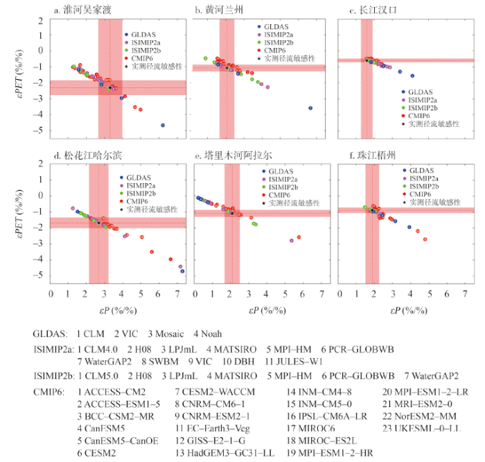
图1
1981—2010年基于多源数据集计算的径流敏感性结果
注:横坐标为径流对降水的敏感性(εP),纵坐标为径流对潜在蒸散发的敏感性(εPET)。黑色星形为实测资料计算的径流敏感性(实测径流敏感性),红色阴影为实测径流敏感性的±20%区间(|bias|<0.20)。
Fig. 1
Runoff sensitivity estimated by multi-source datasets from 1981 to 2010
4.3 多源数据集的径流敏感性评估
4.3.1 多源数据集分类评估
图2
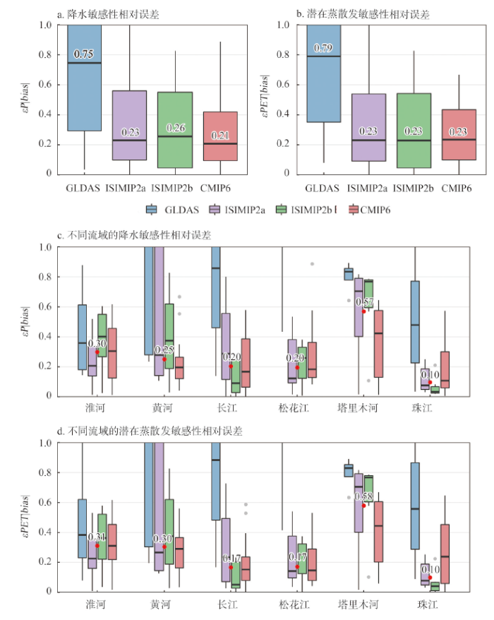
图2
1981—2010年多源数据集的径流敏感性的相对误差箱型图
注:图c和图d中的红点代表该流域所有数据集相对误差的中位数(|bias|median)。
Fig. 2
Box plot of the relative error of the runoff sensitivity of the multi-source datasets from 1981 to 2010
表3 多源数据集径流敏感性的RMSE、MAE、MRE误差
Tab. 3
| 指标 | εP | ||||||||
|---|---|---|---|---|---|---|---|---|---|
| GLDAS | ISIMIP2a | ISIMIP2b | CMIP6 | GLDAS | ISIMIP2a | ISIMIP2b | CMIP6 | ||
| RMSE | 3.33 | 1.12 | 0.89 | 0.86 | 2.04 | 0.64 | 0.49 | 0.52 | |
| MAE | 2.24 | 0.77 | 0.66 | 0.63 | 1.30 | 0.43 | 0.36 | 0.37 | |
| MRE | 1.00 | 0.34 | 0.28 | 0.27 | 1.04 | 0.34 | 0.27 | 0.28 | |
图2c和2d分别展示了4类数据集在不同流域εP|bias|和εPET|bias|。从流域角度来看,多源数据集在湿润的珠江梧州控制流域径流敏感性表现最好(εP|bias|median=0.10、εPET|bias|median=0.10),在干旱的塔里木河阿拉尔控制流域径流敏感性表现最差(εP|bias|median=0.57、εPET|bias|median=0.58)。在淮河吴家渡、黄河兰州、长江汉口、松花江哈尔滨、塔里木河阿拉尔、珠江梧州控制流域,降水敏感性表现最好的数据集分别为ISIMIP2a(εP|bias|median=0.21)、CMIP6(εP|bias|median=0.20)、ISIMIP2b(εP|bias|median=0.09)、ISIMIP2a(εP|bias|median=0.12)、CMIP6(εP|bias|median=0.42)、ISIMIP2b(εP|bias|median=0.03),潜在蒸散发敏感性有相似结论。
4.3.2 多源数据集评估
图3
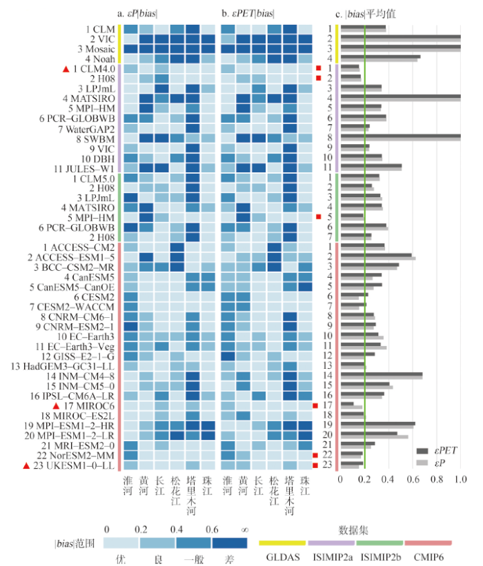
图3
1981—2010年多源数据集的径流敏感性相对误差热图
注:图a为径流对降水敏感性的相对误差(εP|bias|),图b为径流对潜在蒸散发敏感性的相对误差(εPET|bias|),图c为各数据集在6个流域的εP|bias|、εPET|bias|平均值;图a红色三角形表示红色正方形标记的数据集中在6个流域的降水和潜在蒸散发敏感性表现均为良或优(|bias|<0.4)的数据集,图c红色正方形表示数据集在6个流域的降水、潜在蒸散发敏感性平均表现均为优(|bias|平均值<0.2)。
Fig. 3
Heat map of relative error of runoff sensitivity of multi-source dataset from 1981 to 2010
图3展示的子数据集在各流域的表现情况与4.3.1节的分析结果相符,可明显看出在珠江梧州控制流域评估为优的子数据集最多,45套子数据集中仅5套子数据集在降水敏感性或潜在蒸散发敏感性方面表现为差,分别是GLDAS中的VIC、Mosaic,CMIP6中的CanESM5-CanOE、MPI-ESM1-2-HR、MPI-ESM1-2-LR数据集;而在塔里木河阿拉尔控制流域,大部分子数据集均不能模拟好该地区的径流敏感性,整体上超过70%的数据集表现在一般及以下,大量表现为差的数据集中在GLDAS,ISIMIP2a、ISIMIP2b数据集中,CMIP6在塔里木河的表现优于其他3类数据集。总体而言,子数据集在湿润区模拟较好,在干旱区模拟较差,但在湿润的淮河流域,也有相当数量子数据集模拟的径流敏感性效果一般。淮河地区下垫面参数n = 4.53,远高于其它地区,下垫面参数代表了下垫面土壤、地形、植被等条件,推测可能是复杂的下垫面条件导致各数据集不能较好地模拟淮河流域的径流敏感性。径流敏感性模拟效果区域差异性的原因需要进一步探讨。在分析过程中,也发现了一些径流敏感性远远偏离观测值的子数据集,如ISIMIP2a中的SWBM子数据集,其径流敏感性计算结果表明,黄河流域降水增加1%时,径流增加24.83%,潜在蒸散发增加1%时,径流减少25.27%,与实测径流敏感性误差高达4倍以上,MATSIRO子数据集与实测径流敏感性的误差也将近两倍以上,此类误差较高的数据集在图3c呈现的|bias|平均值大于1,未来径流变化预估分析中要注意规避此类数据集,以免对研究结果带来显著误差。
5 讨论
5.1 数据集模拟效果的区域差异性原因
数据集对径流敏感性的模拟在最湿润的珠江梧州控制流域表现最好,而在最干旱的塔里木河阿拉尔控制流域表现不佳,这与前人对水文模型在径流模拟方面的评估结果具有相似性[31]。可能是因为干旱地区植被覆盖状况差,土壤湿度低,包气带较厚,下垫面情况复杂,为典型的超渗产流机制,当前的模型无法准确刻画干旱地区复杂的水力和水文过程[32-33],导致水文模型、陆面模型和地球系统模型对于干旱区的径流响应模拟较差。此外,观测径流受到水土保持、大坝建设、调水工程等人类活动影响,而不同流域受人类活动的影响程度不一,可能也导致了数据集模拟的区域差异性[34-35],未来研究可以探究径流敏感性模拟效果与干旱指数、植被覆盖指数、人类活动情况等多因子的相关性,进一步分析各类数据集在径流敏感性模拟效果方面产生区域差异性的具体原因。
5.2 如何提高径流敏感性模拟能力
除了改进模型结构和参数率定外,也有研究建议采用多模型的集合平均值进行气候变化研究[38]。本文对这一观点进行了初步探索,对4类数据集的降水、潜在蒸散发、径流分别进行集合平均,得到4套集合平均数据集。结果发现在大部分流域集合平均数据集降低了误差,在潜在蒸散发敏感性方面,与4类数据集在各流域的
5.3 研究的不确定性
径流敏感性计算方法的选择是本文不确定性的来源之一。目前的径流敏感性方法主要分为3类,分别是水文模型法、数理统计法以及基于Budyko的解析方法。水文模型法是通过改变水文模型输入得到径流敏感性;数理统计法主要是指基于线性回归等统计方法,构建径流和降水、潜在蒸散发的关系得到径流敏感性;基于Budyko的解析方法是基于不同的Budyko解析公式,构建径流和降水、潜在蒸散发的关系得到径流敏感性。不同方法可能得到不一样的径流敏感性计算结果,未来研究要进一步比较不同敏感性计算方法带来的评估差异。此外,文中基于|bias|的评级分类标准有一定的主观性,但评估结果具有参考价值。
6 结论
本文选择了中国气候条件差异较大的6个流域,以1981—2010年实测气象水文资料计算的径流敏感性为标准,评估GLDAS、ISIMIP2a、ISIMIP2b、CMIP6 4类共45套数据集的径流敏感性表现,得出以下主要结论:① 以每类数据集降水和潜在蒸散发敏感性相对误差中位数为评估指标,GLDAS数据集在径流对降水和潜在蒸散发敏感性方面模拟较差,ISIMIP2a、ISIMIP2b、CMIP6数据集模拟效果差异较小。② ISIMIP2a中的CLM4.0数据集、CMIP6中的UKESM1-0-LL和MIROC6数据集在6个流域表现均为优或良,表明这3套数据集能适应各种气候条件的径流敏感性模拟,推荐这3套数据集用于中国稀缺资料地区径流变化的预估研究。
本文结果可为气候条件相似的稀缺资料流域径流变化预估分析提供参考,未来可拓宽研究区范围,探究不同数据集产生区域模拟差异的原因,尝试从模型参数率定、结构改善等方面提高径流敏感性模拟效果。
参考文献
The global land data assimilation system
DOI:10.1175/BAMS-85-3-381 URL [本文引用: 1]
The Inter-Sectoral Impact Model Intercomparison Project (ISI-MIP): Project framework
DOI:10.1073/pnas.1312330110
PMID:24344316
[本文引用: 1]

The Inter-Sectoral Impact Model Intercomparison Project offers a framework to compare climate impact projections in different sectors and at different scales. Consistent climate and socio-economic input data provide the basis for a cross-sectoral integration of impact projections. The project is designed to enable quantitative synthesis of climate change impacts at different levels of global warming. This report briefly outlines the objectives and framework of the first, fast-tracked phase of Inter-Sectoral Impact Model Intercomparison Project, based on global impact models, and provides an overview of the participating models, input data, and scenario set-up.
Overview of the Coupled Model Intercomparison Project Phase 6 (CMIP6) experimental design and organization
DOI:10.5194/gmd-9-1937-2016 URL [本文引用: 1]
Comparision of GLDAS Noah Model Hydrological Outputs with ground observations and satellite observations in China
GLDAS Noah模型水文产品与中国地面观测及卫星观测数据的对比
Intercomparison of ten ISI-MIP models in simulating discharges along the Lancang-Mekong River basin
Climate model suitability evaluation and drought and flood forecast in Wuliangsuhai basin
乌梁素海流域气候模式适用性评价及旱涝预估
Detection of global runoff changes: Results from observations and CMIP5 experiments
DOI:10.5194/hess-17-2967-2013 URL [本文引用: 1]
Evaluation of streamflow simulation results of land surface models in GLDAS on the Tibetan plateau
DOI:10.1002/2016JD025501 URL [本文引用: 1]
Comparing projections of future changes in runoff from hydrological and biome models in ISI-MIP
DOI:10.5194/esd-4-359-2013 URL [本文引用: 1]
The regional variation in climate elasticity and climate contribution to runoff across China
DOI:10.1016/j.jhydrol.2014.05.062 URL [本文引用: 1]
A global assessment of runoff sensitivity to changes in precipitation, potential evaporation, and other factors
DOI:10.1002/2017WR021593 URL [本文引用: 2]
Responses of streamflow to climate and land surface change in the headwaters of the Yellow River Basin
Runoff sensitivity of Indian sub-continental river basins
Derivation of interannual climate elasticity of streamflow
A simple model for estimating the sensitivity of runoff to long-term changes in precipitation without a change in vegetation
DOI:10.1016/S0309-1708(99)00019-6 URL [本文引用: 1]
A two-parameter climate elasticity of streamflow index to assess climate change effects on annual streamflow
Macroscale water fluxes 2. Water and energy supply control of their interannual variability
Runoff sensitivity to global mean temperature change in the CMIP5 models
DOI:10.1002/2014GL060382 URL [本文引用: 1]
The potential to reduce uncertainty in regional runoff projections from climate models
DOI:10.1038/s41558-019-0639-x URL [本文引用: 1]
Runoff sensitivity over Asia: Role of climate variables and initial soil conditions
DOI:10.1002/2016JD025694 URL [本文引用: 1]
Sensitivity of streamflow in the Colorado Basin to climatic changes
DOI:10.1016/0022-1694(91)90030-L URL [本文引用: 1]
The progresses of dry-wet climate divisional research in China
中国干湿气候区划研究进展
The first high-resolution meteorological forcing dataset for land process studies over China
Globally observed trends in mean and extreme river flow attributed to climate change
DOI:10.1126/science.aba3996
PMID:33707264
[本文引用: 1]
Anthropogenic climate change is expected to affect global river flow. Here, we analyze time series of low, mean, and high river flows from 7250 observatories around the world covering the years 1971 to 2010. We identify spatially complex trend patterns, where some regions are drying and others are wetting consistently across low, mean, and high flows. Trends computed from state-of-the-art model simulations are consistent with the observations only if radiative forcing that accounts for anthropogenic climate change is considered. Simulated effects of water and land management do not suffice to reproduce the observed trend pattern. Thus, the analysis provides clear evidence for the role of externally forced climate change as a causal driver of recent trends in mean and extreme river flow at the global scale.Copyright © 2021 The Authors, some rights reserved; exclusive licensee American Association for the Advancement of Science. No claim to original U.S. Government Works.
Attribution analysis for runoff decline in Yellow River Basin during past fifty years based on Budyko hypothesis
基于水热耦合平衡方程的黄河流域径流变化归因分析
Crop evapotranspiration: Guidelines for computing crop water requirements
Spatial-temporal variation of aridity index during 1961-2014 in China
1961—2014年中国干燥度指数的时空变化研究
Evaluation and verification of CMORPH and TRMM 3B 42 precipitation estimation products
CMORPH和TRMM 3B42降水估计产品的评估检验
A review of the scaling issues of geospatial data
DOI:10.11867/j.issn.1001-8166.2013.03.0297
[本文引用: 1]
<p>As scale is one of the three lenses from which geographers observe and recognize the world, it is of great importance to propose this concept in geographical research. All the natural or cultural phenomena cannot be scientifically observed and modelled without correct scales, thus scaling and scaling effects becoming one of the key problems in geography, ecology, hydrology and meteorology in recent decades. As a core issue in the scale problem, scaling of geospatial data serves as a necessary process in the scale researches. There are level theory, fractal theory, regional variable theory, Tobler’s first law of geography and so on, supporting as the basic theoretical framework in the scaling researches. Many effective scaling approaches reference to geospatial data have been developed, and different methods applied in different areas. In GIS area, vector data can be generalized by such methods as exaggeration, simplification, selection, displacement and other generalizing operations; raster data can be scaled with resampling, fourier analysis, wavelet analysis and fractal analysis, while the scaling methods of remote sensing image can be divided into three kinds, the scaling methods based on pixel, the methods based on imaging mechanism, and the image fusion methods. In this paper, we illustrate the mechanism and applications of four major geospatial scaling methods, i.e. resampling methods, geostatistical methods, fractal analysis and wavelet transformation. Scaling effects are also an important scaling issues, with many researchers involved in the study of geospatial variations of scaling, developing evaluation criteria of scaling, etc. Though there exist some effective scaling methods, few accuracy analysis of scaling has been developed in evaluating resulting data, and researches into scaling theories, methodologies and scaling effects still need to be deepen. Therefore, it is natural trend to develop a theoretical and methodological scaling research frame, as well as to integrated multiscale spatial data with process models of different areas.</p>
地理空间数据的尺度转换
DOI:10.11867/j.issn.1001-8166.2013.03.0297
[本文引用: 1]
尺度一般是指空间范围的大小,地理空间数据的尺度转换是尺度研究的重要问题之一。针对地理信息系统(GIS)技术支持下的地理空间数据尺度转换问题,首先回顾了尺度转换的理论基础,即等级理论、分形理论、区域化随机变量理论、地理学第一定律等理论的基本内涵;然后总结了地理学不同研究领域内主要的尺度转换方法,重点分析了重采样法、变异函数法、分形分维法及小波分析法的基本原理、模型方法与典型应用案例;最后介绍了地理空间数据尺度转换效应研究的进展。基于上述总结和分析认为:构建一套无级变换的、系统的尺度转换方法,整合不同学科领域的数据与过程模型、形成数据模型同化的技术体系,这是地理空间数据尺度转换研究的重要课题。
Study on applicability of conceptual hydrological models for flood forecasting in humid, semi-humid semi-arid and arid basins in China
Applicability of catchment hydrologic models in arid and semi-arid regions
干旱半干旱地区流域水文模型的适用性
Application and comparison of hydrological models for semi-arid and semi-humid regions
半干旱半湿润流域水文模型应用与比较
Impacts of different human activities on hydrological drought in the Huaihe River Basin based on scenario comparison
Impacts of climate and land use/cover changes on runoff in the Hanjiang River basin
DOI:10.11821/dlxb202011003
[本文引用: 1]
As a link between the atmosphere and the geosphere, the hydrological cycle is affected by both climate change and Land Use/Cover Change (LUCC). However, most existing research on runoff response focused mainly on the impact of the projected climate variation, neglecting the influence of future LUCC variability. Therefore, the objective of this study is to examine the co-impacts of both projected climate change and LUCC on runoff generation. Firstly, the future climate scenarios under BCC-CSM1.1 and BNU-ESM are both downscaled and corrected by the Daily Bias Correction (DBC) model. Secondly, the LUCC scenarios are predicted based on the Cellular Automaton-Markov (CA-Markov) model. Finally, the Soil and Water Assessment Tool (SWAT) model is used to simulate the hydrological process under different combinations of climate and LUCC scenarios, with the attempt to quantitatively evaluate the impacts of climate change and LUCC on runoff generation. In this study, the Hanjiang River basin is used as the case study area. The results show that: (1) compared with the base period (1966-2005), the annual rainfall, daily maximum and minimum air temperatures during 2021-2060 will have an increase of 4.0%, 1.8 ℃, 1.6 ℃ in RCP4.5 scenario, respectively, while 3.7%, 2.5 ℃, 2.3 ℃ in RCP8.5 scenario, respectively. (2) During 2010-2050, the area proportions of forest land and construction land in the study area will increase by 2.8% and 1.2%, respectively, while those of farmland and grassland will decrease by 1.5% and 2.5%, respectively. (3) Compared with the single climate change or LUCC scenario, the variation range of future runoff under both climate and LUCC is the largest, and the influence of climate change on future runoff is significantly greater than that of LUCC. This study is helpful to maintain the future water resources planning and management of the Hanjiang River basin under future climate and LUCC scenarios.
气候与土地利用变化对汉江流域径流的影响
DOI:10.11821/dlxb202011003
[本文引用: 1]
作为联结大气圈和地圈的纽带,水文循环同时承受气候变化和土地利用/覆被变化(LUCC)的双重影响,然而大多数的水文响应研究主要关注未来气候变化对径流的影响,忽略了未来LUCC的作用。因此,本文的研究目的是评估未来气候变化和LUCC对径流的共同影响。首先采用2种全球气候模式(BCC-CSM1.1和BNU-ESM)输出,基于DBC降尺度模型得到未来气候变化情景;然后,利用CA-Markov模型预测未来LUCC情景;最后,通过设置不同的气候和LUCC情景组合,采用SWAT模型模拟汉江流域的未来径流过程,定量评估气候变化和LUCC对径流的影响。结果表明:① 未来时期汉江流域的年降水量、日最高、最低气温相较于基准期(1966—2005年),在RCP 4.5和RCP 8.5浓度路径下,分别增加4.0%、1.8 ℃、1.6 ℃和3.7%、2.5 ℃、2.3 ℃;② 2010—2050年间,流域内林地和建设用地的面积占比将分别增加2.8%和1.2%,而耕地和草地面积占比将分别减少1.5%和2.5%;③ 与单一气候变化或LUCC情景相比,气候变化和LUCC共同影响下的径流变化幅度最大,在RCP 4.5和RCP 8.5浓度路径下未来时期年平均径流分别增加5.10%、2.67%,且气候变化对径流的影响显著大于LUCC。本文的研究结果将有助于维护未来气候变化和LUCC共同影响下汉江流域的水资源规划与管理。
Cross-scale intercomparison of climate change impacts simulated by regional and global hydrological models in eleven large river basins
DOI:10.1007/s10584-016-1829-4 URL [本文引用: 1]
Assessing the impacts of reservoir operation to floodplain inundation by combining hydrological, reservoir management, and hydrodynamic models
DOI:10.1002/2013WR014845 URL [本文引用: 1]
Comparing large-scale hydrological model simulations to observed runoff percentiles in Europe
DOI:10.1175/JHM-D-11-083.1 URL [本文引用: 1]
