

1 引言
随着“21世纪海上丝绸之路”(简称“海上丝路”)建设的深化和海洋强国、交通强国战略的实施,海上丝绸之路集装箱海运网络(简称“海上丝路”网络)在保障中国与沿线各国之间设施联通和贸易畅通方面的作用已变得十分重要[1⇓⇓⇓⇓-6]。但近一时期,“海上丝路”范围内新型冠状病毒肺炎疫情愈演愈烈、军事冲突频发、恐怖主义盛行、部分地区政治局势持续动荡,对“海上丝路”网络的稳定运行造成了巨大挑战。在这一背景下,研究蓄意攻击下“海上丝路”网络的脆弱性变化情况,分析其影响因素,进而提出有针对性的安全保障对策和建议,对于持续保障“海上丝路”网络的稳定运行,促进中国与“海上丝路”沿线各国间的设施联通和贸易畅通具有重要理论意义和实用价值。
集装箱海运网络的脆弱性主要指网络中港口或航线失效对网络运输功能的影响程度[7⇓⇓⇓⇓-12]。在这方面的研究成果较为集中,包括如何利用特征值,对集装箱海运网络的脆弱性进行分析[13⇓-15],计算集装箱海运网络对节点和边失效的敏感程度[16⇓-18],建立基于特征值影响权重的集装箱海运网络脆弱性变化评价方法[19-20],以及集装箱海运网络关键节点的识别方法研究[21⇓⇓-24]等。在应用上,现有成果主要研究蓄意攻击下全球集装箱海运网络[25⇓-27]、海上丝绸之路集装箱海运网络[28]和班轮公司集装箱海运网络[29]的脆弱性,集装箱海运网络脆弱性与网络效率之间的关系[30],关键航道通航受阻对网络脆弱性的影响[31-32],中国和全球集装箱海运网络的层级结构[33-34],以及全球集装箱海运网络[35-36]和“海上丝路”集装箱海运网络[37⇓-39]的枢纽港格局等。
现有研究成果主要关注单一年度集装箱海运网络脆弱性的静态特征,相应的研究方法并不完全适用于多年度集装箱海运网络脆弱性变化的研究。对于蓄意攻击下集装箱海运网络脆弱性变化研究而言,其所关注的核心问题是网络对蓄意攻击承受能力的变化情况,这需要对蓄意攻击下不同年度集装箱海运网络的崩溃临界点进行准确识别,并建立相应的集装箱海运网络脆弱性变化程度量化方法。而现有的识别方法主要是根据网络特征值的变化对崩溃临界点进行推测[13,20,28,40],在地理因素方面的考虑不够全面,因而其相应的脆弱性量化结果往往存在一定的偏差。在应用方面,虽然已有研究基本揭示了“海上丝路”网络脆弱性的静态特征,但是自2015年《推动共建丝绸之路经济带和21世纪海上丝绸之路的愿景和行动》(简称《愿景与行动》)发布以来,“海上丝路”网络随“一带一路”经济共同体一同经历了快速的发展和重大的变革,在这一背景和趋势下,需要从持续保障互联互通的角度,对其脆弱性的变化及影响因素进行有针对性的深入研究。
针对以上问题,本文利用2015年和2019年全球集装箱班轮公司在“海上丝路”范围内运营航线及挂靠港口的统计数据开展相关研究,主要贡献包括:① 跳出利用网络特征值对集装箱海运网络脆弱性进行分析的传统研究思路,基于蓄意攻击下集装箱海运网络的地理空间联系变化和网络分裂过程,提出了集装箱海运网络崩溃临界点的识别方法,并建立了相应的集装箱海运网络脆弱性变化趋势和程度的量化方法;② 对“海上丝路”建设以来,“海上丝路”网络在蓄意攻击下的脆弱性变化情况进行了量化分析;③ 探讨了“海上丝路”网络脆弱性变化的驱动机制及其影响因素,并从持续保障“海上丝路”网络互联互通的角度,提出了相应的对策和建议。
2 “海上丝路”网络构建
2.1 数据统计
“21世纪海上丝绸之路”是中国重大的西向发展战略,从广义的角度而言,其集装箱海运网络涉及东亚、东南亚、南亚、非洲东海岸、中东、东地中海、西地中海、欧洲大西洋沿线和波罗的海沿线等多个区域(其中,参照航运公司的运营航区划分,以突尼斯海峡区分东地中海区域和西地中海区域,以斯卡格拉克海峡区分欧洲大西洋沿线区域和波罗的海沿线区域),具体情况如图1所示。本文分别对2015年和2019年全球运力排名前100集装箱班轮公司(占全球集装箱船舶总运力约93%)的运营航线和挂靠港口数据进行了统计。结果显示:2015年全球共有集装箱港口715个(将同一城市的多个港区合并为一个港口),航线2826条,其中,“海上丝路”网络中共有集装箱港口428个,航线2429条,分别占全球集装箱港口和航线总数的59.86%和85.95%;2019年全球共有集装箱港口868个,航线3035条,其中,“海上丝路”网络中共有集装箱港口544个,航线2724条,分别占全球集装箱港口和航线总数的62.67%和89.75%,说明“海上丝路”网络中港口和航线的数量在全球范围内占有较大的比例,且2019年较2015年的占比明显上升。进一步分析发现,2019年“海上丝路”网络中港口和航线的数量分别比2015年增加116个和295条,增幅分别为27.10%和12.14%,增幅较大,具体情况如表1所示。可知,海上丝绸之路建设以来,其沿线集装箱港口的数量和相关航运公司对“海上丝路”网络中集装箱航线的投入均明显增加,“海上丝路”网络的整体规模呈现明显扩张趋势。
图1
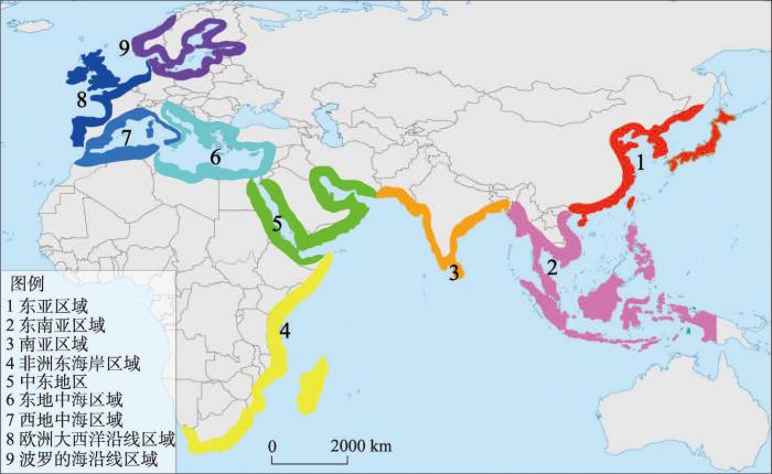
图1
“海上丝路”网络沿线各区域
注:基于自然资源部标准地图服务网站审图号为GS(2016)1665号的标准地图制作,底图边界无修改。
Fig. 1
Regions along Maritime Silk Road container shipping network
表1 2015年与2019年全球和“海上丝路”港口和航线的统计数据对比
Tab. 1
| 全球 | 21世纪海上丝绸之路 | |||||
|---|---|---|---|---|---|---|
| 港口数量(个) | 航线数量(条) | 港口数量(个) | 占比(%) | 航线数量(条) | 占比(%) | |
| 2015年 | 715 | 2826 | 428 | 59.86 | 2429 | 85.95 |
| 2019年 | 868 | 3035 | 544 | 62.67 | 2724 | 89.75 |
| 变化率(%) | 21.40 | 7.40 | 27.10 | 4.69 | 12.14 | 4.42 |
2.2 网络构建
本文在数据统计的过程中,不仅对“海上丝路”中的港口数量、航线数量及其挂靠港口情况进行了统计,还通过航运公司的官方网站和劳氏海事数据库,对各航线运营船舶的船型大小(各船舶能够容纳的箱位数)、班期(航线每周在同一港口挂靠的次数)等详细数据进行了统计。基于以上数据,本文构建了2015年和2019年两个年度的“海上丝路”集装箱海运有向加权网络。其中,以某一航线运营船舶的平均箱位数(同一航线所有运营船舶的箱位数基本相同)与其班期的乘积为该航线在相应挂靠港口之间每周的运力上限(每周平均箱位数),进而对各港口之间所有挂靠航线每周的运力上限进行加和,以之为各港口之间边的运力权重。具体构建方式如下:① 以港口城市为网络中的节点;② 若存在航线依次挂靠节点i和节点j,则认为节点i和节点j之间存在从节点i指向节点j的边,且任意两节点之间某一方向的边最多只有一条;③ 以依次挂靠节点i和节点j所有航线每周挂靠船舶的箱位数之和为从节点i指向节点j有向边的权重,权重越大,则说明两港间对应方向上的运输能力越大;④ 以某一节点所连接有向边(包括入边和出边)的权重之和为该节点的强度,节点强度越大,则节点在网络中影响力越大。
根据上述方式,分别构建2015年和2019年“海上丝路”集装箱海运网络,节点强度排名前10位的港口如表2所示。
表2 2015年和2019年“海上丝路”网络节点强度排名前10位的港口
Tab. 2
| 2015年 | 2019年 | ||||||
|---|---|---|---|---|---|---|---|
| 排名 | 港口名称 | 国家 | 节点强度 | 排名 | 港口名称 | 国家 | 节点强度 |
| 1 | 深圳 | 中国 | 9402800 | 1 | 新加坡 | 新加坡 | 10588100 |
| 2 | 新加坡 | 新加坡 | 9269900 | 2 | 上海 | 中国 | 9616200 |
| 3 | 上海 | 中国 | 8872300 | 3 | 深圳 | 中国 | 8995900 |
| 4 | 香港 | 中国 | 7301900 | 4 | 宁波 | 中国 | 8388700 |
| 5 | 宁波 | 中国 | 6670600 | 5 | 香港 | 中国 | 6297800 |
| 6 | 釜山 | 韩国 | 5342600 | 6 | 釜山 | 韩国 | 6127200 |
| 7 | 巴生 | 马来西亚 | 4720100 | 7 | 巴生 | 马来西亚 | 5605000 |
| 8 | 鹿特丹 | 荷兰 | 3651200 | 8 | 青岛 | 中国 | 3941700 |
| 9 | 高雄 | 中国 | 3272200 | 9 | 高雄 | 中国 | 3539700 |
| 10 | 青岛 | 中国 | 2988500 | 10 | 鹿特丹 | 荷兰 | 3254600 |
3 蓄意攻击下集装箱海运网络脆弱性变化的分析方法
所谓蓄意攻击,即按照节点的重要程度对网络中的节点进行依次删除,这种攻击方式能够模拟重大公共卫生事件、军事冲突、恐怖袭击和罢工等人为因素导致的重大突发事件对网络的影响。研究蓄意攻击情境下集装箱海运网络脆弱性的变化,实际上就是研究集装箱海运网络对蓄意攻击承受能力的变化。在模拟蓄意攻击的过程中,随着攻击港口数量的增加,各年度的集装箱海运网络都将逐渐分裂直至完全崩溃,进而,可以将某年度网络开始崩溃前能够承受的最大攻击规模视为该年度网络对蓄意攻击的承受能力。因此,为了研究蓄意攻击情境下集装箱海运网络的脆弱性变化,需要对各年度网络的崩溃临界点进行准确识别。在这一方面,已有方法主要是基于蓄意攻击下平均路径长度和最大连通子图相对大小等特征值的变化情况对网络的崩溃临界点进行识别[13,20,28,40]。但目前这类基于特征值的崩溃临界点识别方法在识别准确程度方面尚存在不足。具体而言,平均路径长度在蓄意攻击下的变化曲线表现为先震荡上升再震荡下降,当其变化曲线出现第一次下降或者最大值等突变现象时,网络可能尚未出现明显的分裂或者已经错过开始崩溃的临界点,因此基于平均路径长度变化曲线的突变现象对网络崩溃临界点进行识别时的灵敏程度不完全满足准确识别的要求;而最大连通子图相对大小在蓄意攻击下的变化曲线是单调递减的,即其变化趋势不存在明显的突变,当基于最大连通子图相对大小的变化情况对网络开始崩溃的临界点进行识别时,需要对判断网络开始崩溃的阈值进行人为设定,因此其客观性和准确性存在不足。此外,由上一节的数据统计可知,不同年度集装箱海运网络中的港口数量存在较大差异,因此集装箱海运网络脆弱性变化的量化评价还需要考虑网络规模变化这一重要因素。
基于上述分析可知,要定量分析集装箱海运网络脆弱性的变化程度,需要解决两个关键问题:① 如何对网络在蓄意攻击情境下的崩溃临界点进行准确识别;② 如何基于崩溃临界点的识别结果,在考虑网络规模变化的情况下,对网络的脆弱性变化进行合理的量化评价。为此,本文建立了集装箱海运网络脆弱性变化的量化方法,包括崩溃临界点的识别和脆弱性变化的量化评价等两个部分。
3.1 崩溃临界点的识别
在实际中,集装箱海运网络的主要功能是保障相关区域间集装箱海运的互联互通。基于这一本质的认识,本文跳出传统的研究思路,从地理空间联系的角度入手进行思考,认为当集装箱海运网络面对蓄意攻击时,各区域间是否依然保持互联互通是判断网络是否崩溃的主要依据。进而可以认为:随着蓄意攻击港口数量的逐步增加,当某区域突然从网络主体结构(最大强连通子图)中分裂出来与其他各区域不再互联互通时,则网络开始崩溃;当网络主体结构中仅剩一个区域时,则网络完全崩溃。
基于以上思考和认识,为对蓄意攻击下集装箱海运网络的崩溃临界点进行识别,提出最大强连通区域数量的概念,即集装箱海运网络中最大强连通子图所包含地理区域的数量。设集装箱海运网络覆盖地理区域的总数为M,最大强连通区域数量为R,在未遭受攻击或遭受少量蓄意攻击的情况下,R=M,随着蓄意攻击港口数量的增加,R将逐渐减小,则建立蓄意攻击下集装箱海运网络崩溃临界点识别的具体步骤为:① 对当前集装箱海运网络进行模拟蓄意攻击,即删除当前集装箱海运网络中节点强度最大的一个港口;② 计算集装箱海运网络的最大强连通区域数量R;③ 对R和M进行对比,若第一次出现R<M,则此时的蓄意攻击规模为网络开始崩溃的临界点,并记录此时已删除港口的数量;④ 对R和M进行对比,若第一次出现R = 1,则此时的蓄意攻击规模为网络完全崩溃的临界点,并记录此时已删除港口的数量;⑤ 若R >1,则返回步骤①,若R = 1,则结束。
3.2 脆弱性变化的量化评价
通过蓄意攻击下的崩溃临界点识别,可以得到不同年度集装箱海运网络在开始崩溃前能够承受的最大攻击港口数量。然而,集装箱海运网络中的港口总数是不断变化的,如果通过直接对比两个年度网络开始崩溃前能够承受的最大攻击港口数量来反映两个年度网络对蓄意攻击承受能力的变化,则忽略了网络规模变化这一重要因素,其评价结果必然不准确。例如,若两个年度集装箱海运网络在开始崩溃前能够承受的最大攻击港口数量相同,但两个年度网络的港口总数不同,则两个年度网络对蓄意攻击的承受能力应该是不同的,即港口总数多的集装箱海运网络对蓄意攻击的承受能力应该相对较弱。因此,在崩溃临界点识别的基础上,为了考虑网络规模的变化,本文利用集装箱海运网络开始崩溃前能够承受的最大攻击港口数量占其港口总数的比例,对某年度网络的蓄意攻击承受能力进行量化评价,并计算两个年度网络蓄意攻击承受能力的变化率,从而实现对集装箱海运网络脆弱性变化趋势和程度的量化分析。
(1)蓄意攻击承受能力。设At为t年度网络的蓄意攻击承受能力,Zt为t年度网络开始崩溃时遭受攻击的港口数量,Nt为t年度网络中的港口总数,则蓄意攻击承受能力的计算公式为:
(2)蓄意攻击承受能力变化率。集装箱海运网络在t1年度至t2年度的脆弱性变化情况可利用蓄意攻击承受能力变化率V进行量化评价,即:
若V > 0,则说明网络变得更加强壮,若V < 0,则说明网络变得更加脆弱;
4 “海上丝路”网络脆弱性变化的量化分析
图2
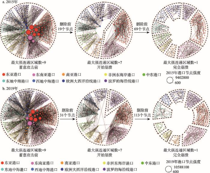
图2
模拟蓄意攻击情景下2015年和2019年“海上丝路”网络的崩溃过程
Fig. 2
Collapse process of Maritime Silk Road container shipping network in 2015 and 2019 under a simulated intentional attack
对于2015年“海上丝路”网络而言,当攻击港口数量小于19个时,各区域间仍保持着互联互通,其最大强连通区域数量等于9;当攻击港口数量达到19个时,东亚和东南亚区域从网络主体结构中分裂出来,最大强连通区域数量从9下降至7,表明网络开始崩溃;当攻击港口数量达到69个时,各区域间均不再互联互通,最大强连通区域数量下降至1,表明网络完全崩溃(图2)。
对于2019年“海上丝路”网络而言,当攻击港口数量小于31个时,各区域间是互联互通的,最大强连通区域数量为9;当攻击港口数量达到31个时,波罗的海沿线区域从网络主体结构中分裂出来,最大强连通区域数量从9下降至8,表明网络开始崩溃;当攻击港口数量达到113个时,各区域间均不再互联互通,最大强连通区域数量下降至1,表明网络完全崩溃。
在蓄意攻击情境下,2015年和2019年“海上丝路”网络在开始崩溃前能够承受的最大攻击港口数量分别为18个和30个。根据式(1)和式(2)进行计算,得到2015年和2019年“海上丝路”网络的蓄意攻击承受能力分别为A2015 = 4.21%和A2019 = 5.51%,2015—2019年“海上丝路”网络的蓄意攻击承受能力变化率V = 30.88%(表3)。综上,从网络系统对蓄意攻击承受能力变化的角度而言,2019年“海上丝路”网络比2015年更加强壮,其变化率为30.88%。
表3 2015年和2019年“海上丝路”网络对蓄意攻击承受能力的对比
Tab. 3
| 年份 | 网络开始崩溃前能够承受 的最大攻击港口数量(个) | 网络的蓄意攻击 承受能力(%) |
|---|---|---|
| 2015 | 18 | 4.21 |
| 2019 | 30 | 5.51 |
| 变化率(%) | 66.67 | 30.88 |
5 “海上丝路”网络脆弱性变化的驱动机制及影响因素
为了探究“海上丝路”网络变得更加强壮的深层次原因,对“海上丝路”网络脆弱性变化的驱动机制及其影响因素进行分析。
5.1 驱动机制
通过对“海上丝路”网络内部结构特征变化的分析,可知“海上丝路”网络变得更加强壮的驱动机制主要包括港口层级结构的差异性减弱、关键港口备份机制日趋完备、东亚和东南亚与其他区域的集装箱海运联系更加紧密等。
5.1.1 港口层级结构的差异性减弱
所谓集装箱海运网络港口层级结构的差异性,是指处于不同层级的港口数量的差异情况。其中,差异性越大,说明集装箱海运的中转运输越集中;差异性越小,说明集装箱海运网络的港口层级结构越均衡。在实际中,集装箱港口可大体分为三个层级,第一层级港口主要包括对维系网络整体互联互通起重要作用的关键港口,若这类港口全部失效,将导致网络出现分裂;第二层级港口主要包括对相邻区域间和区域内中转运输具有一定作用的次级关键港口,若第一层级和第二层级港口全部失效,将导致网络完全崩溃;第三层级港口主要指对网络连通性影响较小的支线/喂给港。因此,可以根据模拟蓄意攻击下2015年和2019年“海上丝路”网络开始崩溃和完全崩溃的临界点,对两个年度网络的港口层级结构进行划分。其中,开始崩溃时遭受攻击的所有港口为关键港口;开始崩溃至完全崩溃期间遭受攻击的所有港口为次级关键港;其余港口为支线/喂给港。进而,得到2015年“海上丝路”网络中关键港口、次级关键港口和支线/喂给港的数量分别为19个、50个和359个,占该年度港口总数的比例分别为4.44%、11.68%和83.88%;2019年“海上丝路”网络中关键港口、次级关键港口和支线/喂给港的数量分别为31个、82个和431个,占该年度港口总数的比例分别为5.70%、15.07%和79.23%(表4)。与2015年相比,2019年“海上丝路”网络中关键港口和次级关键港口的比例相对增加,而支线/喂给港的比例明显减少,即前两个层次港口比例与第三层次港口比例之间的差异明显减弱,使得“海上丝路”网络的港口层级结构逐渐由金字塔结构向梯形结构转变。正是因为港口层级结构的差异性呈现减弱趋势,促使“海上丝路”网络更加趋向于均衡和紧密,所以网络在面对蓄意攻击时变得更加强壮。
表4 2015年和2019年“海上丝路”网络港口层级结构变化
Tab. 4
| 年份 | 关键港口 | 次级关键港口 | 支线/喂给港口 | |||||
|---|---|---|---|---|---|---|---|---|
| 数量(个) | 比例(%) | 数量(个) | 比例(%) | 数量(个) | 比例(%) | |||
| 2015 | 19 | 4.44 | 50 | 11.68 | 359 | 83.88 | ||
| 2019 | 31 | 5.70 | 82 | 15.07 | 431 | 79.23 | ||
5.1.2 关键港口备份机制日趋完备
在实际中,关键港口构成了集装箱海运网络的核心框架,集装箱从始发港到目的港往往需要经过若干个关键港口的中转才能到达,但集装箱在中转运输时一般有多个关键港口可供选择,例如,经上海港中转运输的集装箱也可以经宁波港进行中转。因此,从网络的角度来看,邻近的多个关键港口之间往往存在着一定的备份机制,如果某一港口因突发事件而无法正常运营,其备份港可以帮助受影响的部分航线实现中转运输,保障网络的运行。根据集装箱海运网络的运行机理,若两个关键港口之间存在相互备份关系,需要同时满足2个必要条件:① 两关键港口间的距离较近,应位于同一海运区域内;② 两关键港口之间应存在直接的航线联系。
基于以上认识,对2015—2019年“海上丝路”网络关键港口备份机制的演化情况进行分析。2015年“海上丝路”网络中共有初始关键港口19个,主要分布于东亚(9个)、欧洲大西洋沿线(3个)、东南亚(3个)、中东(2个)、南亚(1个)和东地中海(1个)等区域;2019年的新增关键港口共13个,主要分布于欧洲大西洋沿线(4个)、东亚(3个)、西地中海(2个)、南亚(2个)、东南亚(1个)和东地中海(1个)等区域。2019年退化为次级关键港口的初始关键港口仅有塞得港1个,位于东地中海(图3)。由此可知,2015—2019年“海上丝路”网络中关键港口数量发生变化的区域主要包括东亚、欧洲大西洋沿线、东南亚、南亚和西地中海等5个区域。针对上述5个区域,根据关键港口之间存在相互备份关系的必要条件进行分析,发现2015年具有相互备份关系的初始关键港口,在2019年仍然保持着相互备份关系,而新增关键港口与初始关键港口之间则形成了新的相互备份关系。如图4所示,东亚的上海港、深圳港、宁波港、香港港、釜山港和青岛港的备份港数量均由8个增长至11个;欧洲大西洋沿线的鹿特丹港、安特卫普港、汉堡港的备份港数量均由2个增长至6个;2019年东南亚的林查班港为新增关键港口,与新加坡港、丹戎帕拉帕斯港和巴生港之间形成了新的相互备份关系;2015年南亚的科伦坡港没有备份港,而在2019年孟买港和蒙德拉港成为新增关键港口,与科伦坡港之间形成了相互备份关系;2019年西地中海的热那亚港和阿尔格萨拉斯港等两个新增关键港口之间形成了新的相互备份关系,使得西地中海的关键港口具备了协同抵抗风险的能力。
图3

图3
2015—2019年“海上丝路”网络关键港口的演化情况
注:基于自然资源部标准地图服务网站审图号为GS(2016)1665号的标准地图制作,底图边界无修改。
Fig. 3
Evolution of hub ports in Maritime Silk Road container shipping network in 2015-2019
图4
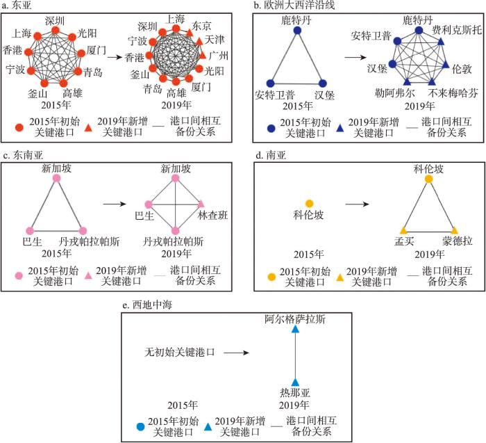
图4
2015—2019年“海上丝路”网络中主要海运区域关键港口的相互备份关系演化情况
Fig. 4
Evolution of mutual backup relationship of key ports in main maritime regions of Maritime Silk Road container shipping network in 2015-2019
进一步将东亚、欧洲大西洋沿线、东南亚、南亚和西地中海等5个区域中各关键港口的备份港数量分别进行加和平均,可以得到各区域的平均备份港数量(图5)。2015—2019年期间,东亚区域关键港口的平均备份港数量由7.78个增加至10.17个,欧洲大西洋沿线区域关键港口的平均备份港数量由2个增加至6个,东南亚区域关键港口的平均备份港数量由2个增加至3个,南亚区域关键港口的平均备份港数量由0个增加至2个,西地中海区域关键港口的平均备份港数量由0个增加至1个。由此可知,2015—2019年期间,东亚、欧洲大西洋沿线、东南亚、南亚和西地中海等5个海运区域的关键港口备份机制均变得更加完备,使得“海上丝路”网络应对突发事件的能力大幅提升。
图5
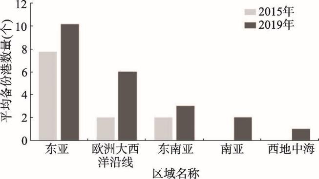
图5
2015年和2019年“海上丝路”网络中主要海运区域关键港口的平均备份港数量演化情况
Fig. 5
Evolution of average number of backup ports for key ports in main maritime regions of Maritime Silk Road container shipping network
5.1.3 东亚和东南亚与其他区域的集装箱海运联系更加紧密
2015年的“海上丝路”网络,仅19个港口遭受蓄意攻击时东亚和东南亚区域子网络就首先从网络主体结构中分裂出来,导致网络开始崩溃,据此可以认为东亚和东南亚是2015年“海上丝路”网络在蓄意攻击下的脆弱性敏感区域;而2019年的“海上丝路”网络,当模拟蓄意攻击的港口数量达到61个和82个时,东亚和东南亚区域子网络才分别从网络主体结构中分裂出来,说明东亚和东南亚区域子网络对蓄意攻击的敏感程度明显减弱。为探究其原因,对东亚和东南亚港口与其他区域(“海上丝路”中除东亚和东南亚以外的区域)港口间的航线联系情况进行了分析。2015年东亚和东南亚港口分别与其他区域中的84个和97个港口存在航线联系,而2019年东亚和东南亚港口分别与其他区域中的98个和111个港口存在航线联系,各增加了14个,增幅分别为16.67%和14.43%(表5)。说明东亚和东南亚与其他区域间的集装箱海运联系变得更加紧密,促使“海上丝路”网络承受蓄意事件破坏的能力逐渐提升。
表5 2015年和2019年与东亚和东南亚港口存在航线联系的其他区域港口的数量变化
Tab. 5
| 与东亚港口存在航线 联系的其他区域港口 的数量(个) | 与东南亚港口存在航线 联系的其他区域港口 的数量(个) | |
|---|---|---|
| 2015年 | 84 | 97 |
| 2019年 | 98 | 111 |
| 变化率(%) | 16.67 | 14.43 |
5.2 影响因素
针对“海上丝路”网络的行为主体,从航运公司的航线布局、港口运营商的联盟策略、国际合作和国际贸易等角度,对形成上述驱动机制的主要影响因素进行分析。
5.2.1 跨区域集装箱航线及其挂靠港口的数量增加
“海上丝路”网络中跨区域航线的数量由2015年的1133条增加至2019年的1232条,增加了99条,说明网络中各区域间航线的整体密度有所增加。但仅依靠跨区域航线数量的变化,还不足以揭示网络中各区域港口间连接紧密程度的变化情况。因此,进一步对跨区域航线的挂靠港口数量进行了分析,发现所有跨区域航线的平均挂靠港口数量由2015年的6.90个增加至2019年的7.21个,其中东亚、东南亚与欧洲大西洋沿线、西地中海、东地中海之间的大部分长距离洲际集装箱干线所挂靠的港口数量均呈现增加趋势(图6)。这一航线布局的变化,使得“海上丝路”网络中挂靠跨区域航线的港口数量由2015年的275个增加至2019年的344个,增加了69个(其中东亚2个、东南亚15个、南亚5个、东地中海16个、西地中海8个、波罗的海沿线25个),说明跨区域航线将更多的港口直接连接在一起,促进了新枢纽港的形成和港口备份机制的发展,提升了“海上丝路”网络中各区域港口之间的连接紧密程度。
图6
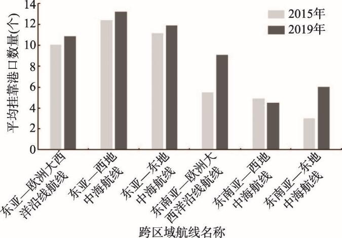
图6
2015年和2019年主要跨区域航线的平均挂靠港口数量变化
Fig. 6
Changes in the average number of ports of call for major cross-regional routes in 2015 and 2019
5.2.2 港口联盟和港航联盟深化发展
据联合国贸发会议出版的《海运述评》显示,全球排名前10位的国际集装箱码头运营商在世界集装箱港口运营份额中所占的总比例由2015年的38.1%增加至2018年的70.2%(表6),增长了近1倍,说明正在有越来越多的集装箱港口接受国际集装箱码头运营商的运营和管理,促进了港口与港口之间联盟(简称“港口联盟”)的深化发展。在这一背景下,集装箱港口的服务标准日渐统一(例如中远海运在“海上丝路”范围内共参与运营13个国家的32个港口或码头,其服务标准基本相同)、作业效率普遍提高(全球集装箱船的平均在港时间由2016年的0.87 d减少至2019年的0.69 d,数据来源为联合国贸发会议出版的《海运述评》),为航运公司的航线在单位时间内多挂靠港口提供了必要条件。与此同时,许多国际集装箱码头运营商自身也是航运公司,如马士基、地中海航运、中远海运、招商局、达飞海运、长荣海运等。因此,在港口联盟深化发展的同时,也促成了港口与航运公司之间联盟(简称“港航联盟”)的发展。当航运公司获得某港口(或码头)的经营权后,将会围绕该港口调整航线布局,使其航线网络更加优化。此外,当航运公司的船舶在本公司参与运营的码头靠泊时,往往不需要排队,在一定程度上减少了其船舶的在港时间,进一步为“海上丝路”范围内的集装箱干线在单位时间内多挂靠港口增加了可能性,为“海上丝路”网络向更加连通、更加强壮方向的发展创造了空间。
表6 2015年和2018年国际集装箱码头运营商的市场份额变化
Tab. 6
| 2015年 | 2018年 | ||||||
|---|---|---|---|---|---|---|---|
| 排名 | 国际集装箱 码头运营商 | 作业量 (百万TEU) | 市场份额 (%) | 排名 | 国际集装箱 码头运营商 | 作业量 (百万TEU) | 市场份额 (%) |
| 1 | 新加坡国际港务集团 | 53 | 7.7 | 1 | 中远海运集团 | 106 | 13.5 |
| 2 | 和记港口集团 | 47 | 6.9 | 2 | 和记港口集团 | 83 | 10.5 |
| 3 | 迪拜环球港务集团 | 37 | 5.4 | 3 | 新加坡国际港务集团 | 80 | 10.2 |
| 4 | 马士基集团 | 36 | 5.2 | 4 | 马士基集团 | 79 | 10 |
| 5 | 招商局集团 | 26 | 3.8 | 5 | 迪拜环球港务集团 | 70 | 8.9 |
| 6 | 中国远洋运输集团 | 20 | 3 | 6 | 地中海航运集团 | 48 | 6.1 |
| 7 | 地中海航运集团 | 18 | 2.7 | 7 | 招商局集团 | 35 | 4.4 |
| 8 | 中海集团 | 9 | 1.3 | 8 | 达飞海运集团 | 26 | 3.3 |
| 9 | 长荣海运集团 | 8 | 1.1 | 9 | 欧门港务集团 | 14 | 1.7 |
| 10 | 欧门港务集团 | 7 | 1 | 10 | 美国海运装卸公司 | 13 | 1.6 |
| 合计 | 261 | 38.1 | 合计 | 554 | 70.2 | ||
注:数据来源于联合国贸发会议出版的《海运述评》。
5.2.3 国际合作和国际贸易的影响
根据中国外交部统计,截止到2019年第二届“一带一路”国际合作高峰论坛举行之前,已有126个国家和29个国际组织同中国签署了“一带一路”的合作协议,促进了“海上丝绸之路”沿线各国的政策沟通、设施联通、贸易畅通、资金融通和民心相通。同时,中国与“海上丝路”沿线的主要国家还利用G20和金砖五国等合作框架展开了较为良好的合作。在这一背景下,亚洲和欧洲之间的集装箱贸易量由2015年的约21百万TEU增长至2019年的约25百万TEU,增幅约为19.05%,远高于同一时期全球的集装箱贸易量增长幅度(约11.76%),且亚洲和欧洲之间的集装箱贸易量占全球集装箱贸易量的比例由2015年的约15.44%增长至2019年的约16.45%(表7)。上述国际合作的加强和国际贸易的增长,为“海上丝路”网络的快速成长和优化发展提供了支持和动力。
表7 2015年和2019年亚洲和欧洲之间的集装箱贸易量变化
Tab. 7
| 年份 | 亚洲和欧洲之间的集装箱贸易量(百万TEU) | 全球集装箱贸易量(百万TEU) | 占比(%) |
|---|---|---|---|
| 2015 | 21 | 136 | 15.44 |
| 2019 | 25 | 152 | 16.45 |
| 变化率(%) | 19.05 | 11.76 | - |
注:数据来源于联合国贸发会议出版的《海运述评》。
6 结论与讨论
6.1 结论
本文基于蓄意攻击下集装箱海运网络的地理空间联系变化和网络分裂过程,提出了蓄意攻击下集装箱海运网络崩溃临界点的识别方法,并建立了相应的集装箱海运网络脆弱性变化程度的量化方法。利用上述方法,基于2015年和2019年全球航运公司运营航线和挂靠港口的统计数据,对《愿景和行动》发布以来“21世纪海上丝绸之路”网络在蓄意攻击下的脆弱性变化情况进行了研究,并对其影响因素进行了详细分析,主要结论为:
(1)2015—2019年期间,“海上丝路”网络中的集装箱港口数量由428个增加至544个,航线数量由2429条增加至2724条,增幅分别为27.10%和12.14%,网络呈现明显的扩张趋势。
(2)在蓄意攻击情境下,2015年和2019年“海上丝路”网络在开始崩溃前能够承受的最大攻击港口数量分别为18个和30个,即2015年和2019年“海上丝路”网络的蓄意攻击承受能力分别为4.21%和5.51%,表明2019年“海上丝路”网络比2015年更加强壮,其相对变化率为30.88%。随着海上丝绸之路建设的不断深化,“海上丝路”网络愈发强壮的趋势可能进一步延续。
(3)“海上丝路”网络中关键港口和次级关键港口所占比例明显增加,港口层级结构的差异性减弱;东亚、欧洲大西洋沿线、东南亚、南亚和西地中海等海运区域的关键港口备份机制显著增强;东亚和东南亚与其他区域间的集装箱海运联系更加紧密,以上3个方面是“海上丝路”网络对蓄意攻击的承受能力显著提升的主要驱动机制。同时,跨区域集装箱航线及其挂靠港口的数量增加、港口联盟和港航联盟深化发展、国际合作和国际贸易的增加是形成上述驱动机制的主要影响因素。
6.2 讨论
2020年以来“21世纪海上丝绸之路”范围内新型冠状病毒肺炎疫情影响巨大,部分地区政局动荡不安,军事冲突愈演愈烈,恐怖主义长期存在,对中国集装箱海运的安全保障造成了巨大的挑战。本文结合当前形势和上述研究结论,从安全保障的角度,对“海上丝路”网络的建设和发展提出以下对策建议:
(1)建立针对重大突发事件的安全风险预警与应急保障机制。针对“海上丝路”范围内可能长期存在的重大公共卫生安全威胁、军事冲突、恐怖袭击和罢工等风险,应建立有效的风险预警和应急保障机制,为中国的集装箱航线提供实时的风险预警,协助相关船舶避开高危港口和航道,并在某港口或航线出现重大突发事件时提供相应的应急保障和紧急救援措施,避免不必要的损失。
(2)充分发挥中国大型航运企业整合所形成的合力优势,打造多核的海外关键港口布局。随着中国与“海上丝路”沿线各国间经济贸易联系的日益紧密,如何提高中国集装箱航线海外一端的运行效率和安全保障水平变得十分重要而紧迫。针对目前“海上丝路”各区域中关键节点不断增加的现实情况,中国应充分利用中远海运集团和招商局集团完成相应资源整合所形成的规模优势和资金优势,增加对海外关键港口的建设和投资,尤其在东南亚、南亚、地中海和欧洲大西洋沿线等重要区域应合力打造多核的海外关键港口布局,建立海外港口的“备份机制”,进一步提升中国与“海上丝路”沿线各区域间集装箱海运的互联互通水平和抵抗风险能力。
(3)优化国内港口和航线的资源配置,进一步突出中国关键港口的国际中转作用。目前,中国港口已形成了明显的层级结构,为进一步提高中国集装箱海运航线国内一端的运行效率,中国应加强国内沿海各港口与上海港、深圳港、宁波港和青岛港等重要关键港口的联系,减少进出口航线的中转次数,促进中国集装箱海运网络的高效稳定运行。
在本文的研究中对关键港口之间的相互备份关系进行了识别。但某一关键港口可能具有多个备份港,各备份港的优先级和对目标港口的备份程度也存在较大差异。因此,如何对备份港的优先级和备份程度进行量化分析是下一步需要研究的内容。
参考文献
One Belt and One Road: The grand geo-strategy of China's rise
DOI:10.11821/dlyj201506001
[本文引用: 1]

Currently, the rise of China has led its development history into a particular stage. With the economic interests spreading to every part of the world and facing a tighter external constraint, China has to make a geo-strategic breakthrough urgently. As the structural defect remains in the comprehensive strength of China, its global strategy should be firstly deployed in Eurasia, which has been the center of the world political arena. As the first attempt that China has made to reshape Eurasia in the new geographical and historical situation, the "One Belt and One Road" Initiative has pointed out a geographic direction for China's global strategy in the 21st century. The two "Silk Roads" run through the rimland of southern Eurasia and the heartland of central Eurasia, connecting almost total strategic pivots in this continent from east to west spatially. Its successful implementation will endow China with the ability to create the strategic position of Eurasia, greatly improve China's external security environment and expand its interests borderland. From the spatial dimension and the time dimension, this paper analyzes the geo-strategic meaning of the "One Belt and One Road" Initiative, predicts the four possible geo-strategic risks in its enforcement and summarizes its five geographic pivots. Based on these, the authors try to sketch the contours of the "One Belt and One Road" geo-strategy.
“一带一路”: 中华民族复兴的地缘大战略
DOI:10.11821/dlyj201506001
[本文引用: 1]
当前中国已经发展到一个特定历史节点,在经济利益已经遍布世界的同时,必须面对日渐趋紧的外部约束,因此亟须在国际上实现战略突破。欧亚大陆是世界政治舞台的中心,在综合国力尚存结构性缺陷之际,中国的全球战略应围绕欧亚大陆率先展开部署。“一带一路”为21世纪中国国家大战略指明了地理方向,是中国在新的地理历史条件下融入欧亚大陆的第一次尝试。在空间上,“一带一路”分别从欧亚大陆中部心脏地带和南部边缘地带,从东向西把这块大陆上的主要战略枢纽区串连了起来,其成功实施将赋予中国作为重要力量参与欧亚大陆战略态势的基本能力,并极大优化中国外部安全环境。从时间和空间两个维度分析“一带一路”的地缘战略内涵,预测“一带一路”建设中可能遇到的四大战略风险,提出“一带一路”的五大地理支点,勾勒出“一带一路”地缘战略的总体轮廓。
Network structure and proximity of the trade network in the Belt and Road region
DOI:10.11821/dlyj201811008
[本文引用: 1]
<p>The Belt and Road Initiative (B&R) is aimed at building a multi-faceted, multi-dimensional, and a compositely interconnected network. The B&R orderly accelerates the free flow of economic factors across the area and further increases the integrated efficiency of regional economic resources in the B&R region, which has significant influence on reshaping the political and economic landscape of Eurasia and optimizing the geopolitical environment around China. Based on the complex network theory and the geostatistical analysis, this research focuses on the topological features and the spatial structure of the B&R trade network and the proximity of its nodes, by building a database and applying the related techniques, such as ArcGIS, Pajek, and Stata. The main conclusions are as follows: (1) The trade network in the B&R region is a small world and scale-free network. It keeps growing and follows the optimum selection rules, which means the new nodes preferably connect with the existing nodes of higher degree in the network. (2) Countries in the B&R trade network display the typical core-periphery hierarchical character. China plays a leading role in promoting industrial upgrading and economic development for these countries. (3) The structure of the B&R trade network shows a "mixed" structure, including both the hub-spoke and the fully-connected modes. The spatial heterogeneity among different kinds of centralities is significant. (4) The extended gravity model can better explain the B&R trade network. There exist the "Powers' Effect" and the "Geographical Proximity Effect" in the trade relationship. In the B&R trade network, scientific and language proximity are the most important forces. Institutional proximity shows a significantly negative effect, while cultural proximity shows a relatively weak effect. As a result, China should develop diverse policies that are based on different spatial levels, enhance the trade with the neighbouring countries first, and then to the distant ones and their surrounding areas; leverage the advantage of scientific and language proximity to promote the trade with other countries, and strengthen the cultural infiltration along the B&R region.</p>
“一带一路”沿线国家贸易网络空间结构与邻近性
DOI:10.11821/dlyj201811008
[本文引用: 1]
“一带一路”倡议致力于构建全方位、多层次、复合型的互联互通网络,沿线国家之间相互贸易形成的网络有利于加速经济要素跨区域的自由流动,进一步提升“一带一路”区域经济资源的整合效率,对重塑欧亚大陆政经版图和优化中国地缘环境具有重大影响。采用复杂网络和地统计方法,借助GIS、Pajek、Ucinet和数据库等技术手段,对“一带一路”贸易网络的拓扑性质、空间结构以及节点的邻近性深入研究。主要结论有:① “一带一路”沿线国家贸易网络具有小世界和无标度性质,遵循增长性和择优选择;② 沿线国家贸易具有典型的“核心—边缘”等级性,中国对沿线国家产业升级和经济发展具有引领和带动作用;③ 贸易网络是“混合型”结构,呈现枢纽辐射式为主、全连通式并存的联系模式,不同中心性空间分布差异显著;④ 拓展引力模型对“一带一路”沿线国家贸易网络具有较强的解释力,贸易关系存在大国效应和地理邻近效应,科研邻近和语言邻近是重要的推动力,制度邻近的影响呈显著负相关,文化邻近的正向作用相对较弱。因此,中国宜遵循“由近及远”的原则,重点强化对邻近国家的贸易渗透,再加强对沿线重点国家的贸易辐射,进而向重点国家的周边地区拓展,从不同空间层次制定差异化政策,发挥科研和语言邻近的推动作用,强化对沿线国家的文化渗透。
Commodity structure of trade between China and countries in the Belt and Road Initiative area
DOI:10.11820/dlkxjz.2015.05.005
[本文引用: 1]
Economic cooperation is one of the priority areas in the "Belt and Road Initiative" proposed by China. It is important to examine the characteristics and patterns of development of trade between China and countries in the "Belt and Road Initiative" area, for achieving "unimpeded trade" and promoting economic prosperity and regional cooperation. Under this background, this article reviews the changing trend of commodity structure of trade between China and countries in the "Belt and Road Initiative" area, and analyzes the commodity structure and pattern, based on the revealed comparative advantage index (RCA), sensitive industry identification method, and k-medium value clustering. The results show that the commodity structure of China's export to these countries has improved, while import has been more centralized with increasing share of energy. Second, the main products that China exports to these countries are mechanical equipment and textiles and garments, while the main products that China imports are mostly energy, textiles and garments, and mechanical equipment. Third, sensitive industries involved in China's exports include clothing and shoes, nonmetallic minerals, transportation equipment and so on, and those involved in China's imports are mainly ores, energy, and some primary processed products. Fourth, at the provincial level, eastern, central, and some western provinces that do not share border with other countries, are mainly connected to Southeast Asia, West Asia, and Middle East, while western and northern border provinces are mainly dependent on trade with neighboring countries in the area, and have more ties with Central Asia, South Asia, and Mongolia-Russia. Most eastern provinces, central provinces, and several fast-growing western provinces are mainly exporting mechanical equipment, while most northwestern provinces are mainly exporting clothing. On the other hand, energy is the main product imported to Qinghai, Xinjiang, Liaoning, Heilongjiang, and other eastern provinces, while ores and metal products are main imported to most western provinces.
中国与“一带一路”沿线国家贸易的商品格局
DOI:10.11820/dlkxjz.2015.05.005
[本文引用: 1]
经贸合作是“一带一路”建设的重点内容之一。研究中国与“一带一路”沿线国家的经贸合作演变特点及格局,对于促进沿线各国经济繁荣与区域经济合作,实现“贸易畅通”具有重要意义。本文在文献回顾的基础上,基于大量的数据分析,梳理了2001年以来中国与沿线国家贸易的商品结构演化历程,并采用显性比较优势指数、敏感性行业度量及k值聚类算法等,对中国与沿线国家贸易商品结构及格局进行了深入分析。研究结果显示:①中国对沿线国家的出口商品结构有所优化,进口商品结构日趋集中,能源及劳动密集型产品比重上升;②中国与沿线国家贸易的商品结构与各国出口优势行业基本一致;③中国与经济规模相对较小且产业结构较为单一的国家存在一些敏感性行业,出口方面涉及服装鞋帽、矿物制品及交通运输设备等,进口主要涉及能源、矿砂及一些资源初级加工品;④由于国内各省发展差距明显,中国出口商品的空间连续性较差。
Discursive construction of the Belt and Road Initiative: From neoliberal to inclusive globalization
DOI:10.18306/dlkxjz.2017.11.001
[本文引用: 1]
There is an increasing international consensus that the Belt and Road Initiative (BRI) affords a platform for increasingly more countries to explore new international economic governance mechanisms and new development paths. In the meantime, neoliberal globalization has arrived at a crossroads, while anti-globalization voices are louder and practices more frequent since the 2008 global financial crisis, challenging the future of globalization at the scale of the world as a whole. Against this background, political elites and scholars increasingly see the BRI as a possible alternative and new globalization path and, in particular, as a path towards inclusive globalization. Based on a brief review of the process and mechanisms of global economic expansion, and a critique of neoliberal globalization, this article tries to use the vision and actions proposed by the BRI to develop the concept of inclusive globalization. The article suggests that inclusive globalization involves at least the following dimensions: a better and more powerful role of state as a mediator to ensure social justice and stability; correcting the duration mismatch in financial markets and provision of more patient capital to finance infrastructure development, productive activities, and real services in economically less-developed countries and regions; encouraging countries to choose and experiment with development paths that best fit their national conditions and values; enabling all stakeholders to participate equally in globalization; and protecting cultural diversity while promoting economic globalization. Although these dimensions are not sufficient to delineate in detail inclusive globalization, they at least point to several directions for future research on the topic and may offer some support for discursive construction of the BRI.
“一带一路”倡议的理论建构: 从新自由主义全球化到包容性全球化
DOI:10.18306/dlkxjz.2017.11.001
[本文引用: 1]
中国政府提出的“一带一路”倡议正在成为世界上越来越多国家共同探索国际经济治理新机制的一个平台。与此同时,以新自由主义为旗帜的经济全球化已经走到“十字路口”,逆全球化的声音不绝于耳,如何推动全球化进一步发展已成为世界性挑战。在此背景下,越来越多的政治精英和学者认为“一带一路”将引领新型全球化道路,其中一个重要的探索方向就是包容性全球化。本文在简要剖析经济全球扩张的历程及其机制并揭示新自由主义全球化局限性的基础上,结合“一带一路”的实践活动,提出了包容性全球化的核心内涵,包括国家应发挥好“调节者”的角色、解决资本市场“期限错配”的问题、选择适合国情的发展道路、保障各方平等地参与全球化,以及在经济全球化过程中保护文化多元性。尽管这些内涵还不足以精确地定量刻画包容性全球化,但可为后续研究提供一些借鉴的方向,也为“一带一路”建设提供了理论思考的方向。
The Belt and Road production networks and China's participation
“一带一路”生产网络及中国参与程度
DOI:10.18306/dlkxjz.2019.07.001
[本文引用: 1]
随着全球化深入发展,全球生产网络已经成为协调和组织全球生产活动最主要的组织平台。共建“一带一路”倡议的提出标志着包容性全球化时代的到来,中国也将更快速、深入地融入全球生产网络中。在此背景下,“一带一路”沿线地区内部是否形成了较强的生产网络联系,中国在其中的参与程度又如何,是一个非常有意义的研究议题。论文基于全球生产网络视角,运用投入产出分析、增加值分解以及网络分析等方法,开展了定量研究。结果表明:① 研究期内,“一带一路”区域内部生产网络联系强度不断提升;② 中国在“一带一路”生产网络价值流动中处于核心和首位地位,且首位优势不断增强;③ 中国获取增加值空间分布上,呈现出东高西低、东南集聚的空间特征,东南亚是中国获取增加值的最主要来源地;④ 中国从“一带一路”沿线国家最终品中获取增加值效率较低,面临着“低端锁定”的困境,价值捕获能力亟待进一步提升。因此,中国应加大空间整合力度,最大化与“一带一路”区域的生产合作,同时进行由增量到提质的发展方式转型,提升增加值获取效率,为中国经济发展找到新的增长点。
Scientific understanding of the Belt and Road Initiative of China and related research themes
DOI:10.11820/dlkxjz.2015.05.001
[本文引用: 1]
The Belt and Road Initiative—where the "Belt" stands for the Silk Road Economic Belt and the "Road" stands for the 21st Century Maritime Silk Road—is a call of China for new modes of regional economic cooperation under the trend of development of economic globalization. It targets at promoting orderly and free flow of economic factors, efficient allocation of resources, and deep integration of markets; enabling the countries along the Belt and Road to achieve economic policy coordination and carry out broader, deeper, and more efficient economic cooperation; and jointly building an open, inclusive, and balanced regional economic cooperation architecture. Thus the Belt and Road Initiative is an alternative road to further economic globalization, but contains ideas that are different from the past, that is, the spirit of the Silk Road—"peace and cooperation, openness and inclusiveness, mutual learning and win-win." Based on such an understanding, this article first analyzes the general background of the Belt and Road Initiative against economic globalization and the changing configurations of the world, and then discusses the Initiative's spatial connotation by revealing its multi-scalar and trans-scalar characteristics. The article points out that the Belt and Road Initiative is a national strategy, rather than a regional strategy, to coordinate all-around opening of China to the world and promote further integration of the country into the global economy. Last, the article suggests several research themes in geography that are brought about by the Belt and Road Initiative, including geopolitical studies, geography of countries of the region to explore cooperation opportunities, foreign direct investment theories advanced by the Belt and Road Initiative, and optimization of transcontinental transportation.
“一带一路”战略的科学内涵与科学问题
DOI:10.11820/dlkxjz.2015.05.001
[本文引用: 1]
“一带一路”指“丝绸之路经济带”和“21世纪海上丝绸之路”,是中国为推动经济全球化深入发展而提出的国际区域经济合作新模式。其核心目标是促进经济要素有序自由流动、资源高效配置和市场深度融合,推动开展更大范围、更高水平、更深层次的区域合作,共同打造开放、包容、均衡、普惠的区域经济合作架构。“一带一路”框架包含了与以往经济全球化完全不同的理念,即“和平合作、开放包容、互学互鉴、互利共赢”,这正是丝绸之路文化内涵的体现。本文分析了“一带一路”战略与经济全球化及世界格局变化的关系;剖析了其空间内涵,认为“一带一路”具有多重空间内涵和跨尺度特征,是统筹中国全面对外开放的国家战略。最后,提出了推进“一带一路”建设为地理学提出的几个重要议题,包括地缘政治、国别地理、对外直接外资理论、交通运输优化组织等。
Vulnerability of international freight flows to shipping network disruptions: A multiplex network perspective
Peripherality in the global container shipping network: The case of the Southern African container port system
Universal resilience patterns in complex networks
DOI:10.1038/nature16948 URL [本文引用: 1]
A review and prospect for the complexity and resilience of urban public transit network based on complex network theory
Transport resilience and vulnerability: The role of connectivity
DOI:10.1016/j.tra.2014.12.012 URL [本文引用: 1]
Vulnerability and resilience of transport systems: A discussion of recent research
DOI:10.1016/j.tra.2015.06.002 URL [本文引用: 1]
The robustness evaluation of global maritime transportation networks
全球海洋运输网络健壮性评估
DOI:10.11821/dlxb201712009
[本文引用: 3]
海洋运输网络结构健壮性与运输效率密切相关,也是海洋运输系统抗干扰能力的具体表现。目前的海洋运输网络健壮性研究主要基于集装箱班轮运输网络开展,忽略了货运船舶的多态性。针对上述问题,本文利用2015年全球海洋货物运输船舶自动识别系统(Automatic Identification System, AIS)数据,构建了包含港口中转停留信息的全球海洋货物运输网络,然后从原油、集装箱、散货三种货物运输模式网络入手,证明其结构符合幂律分布,并采用随机性攻击和蓄意攻击策略,分析了三种网络在不同攻击策略下的破碎过程。结果表明:① 与基于集装箱班轮起止港口信息构建的运输网络相比,利用货运船舶AIS数据构建的运输网络更完整地反映了全球海洋运输格局和过程;② 不同货运网络结构健壮性存在巨大差异,散货运输网络最健壮,其次为原油运输网络,集装箱运输网络最脆弱;③ 小规模的蓄意攻击会对集装箱运输网络完整性产生较大的影响,而对散货运输网络和原油运输网络完整性影响较小。研究成果可为港口规划、航线设计与优化以及建立更可靠的海洋运输网络体系提供参考和决策支持。
Research on the connectivity of shipping route network based on complex network
基于复杂网络的海运航线网络连通性分析
Connectivity analysis of container shipping network of "21st Century Maritime Silk Road"
“21世纪海上丝绸之路”集装箱海运网络连通性分析
The vulnerability of the global container shipping network to targeted link disruption
DOI:10.1016/j.physa.2016.06.111 URL [本文引用: 1]
Hub dependence in constrained economies: The case of North Korea
Centrality and vulnerability in liner shipping networks: Revisiting the Northeast Asian port hierarchy
The change of global container shipping network vulnerability under intentional attack
蓄意攻击下全球集装箱海运网络脆弱性变化
DOI:10.11821/dlxb201602009
[本文引用: 1]
为探究近年来全球集装箱海运网络脆弱性的变化趋势,提出了研究网络脆弱性变化度的分析思路和量化方法.基于2004和2014年两个年度的世界主要集装箱班轮公司航线分布数据,将相关港口按节点度大小排序后以1%~10%的比例逐步删除,选择删除前后的网络平均度,网络聚类系数,网络孤立节点比例,网络平均距离和网络效率等特征值的变化率作为量化指标;提出了网络压力测试方法,由此求出各特征值对网络脆弱性的影响权重及贡献值,进而得到了在设定攻击规模内集装箱海运网络脆弱性变化的量化值.研究结果表明:在蓄意攻击下,近10年的全球集装箱海运网络的脆弱性呈变差趋势;当攻击规模为整体网络的10%以内时,网络脆弱性的变差幅度约为6.1%.研究成果对于深化港口地理学研究具有重要意义,其分析思路和方法对其他领域的网络脆弱性变化趋势研究也可提供借鉴.
A study of the temporal robustness of the growing global container-shipping network
Whether they thrive as they grow must be determined for all constantly expanding networks. However, few studies have focused on this important network feature or the development of quantitative analytical methods. Given the formation and growth of the global container-shipping network, we proposed the concept of network temporal robustness and quantitative method. As an example, we collected container liner companies' data at two time points (2004 and 2014) and built a shipping network with ports as nodes and routes as links. We thus obtained a quantitative value of the temporal robustness. The temporal robustness is a significant network property because, for the first time, we can clearly recognize that the shipping network has become more vulnerable to damage over the last decade: When the node failure scale reached 50% of the entire network, the temporal robustness was approximately -0.51% for random errors and -12.63% for intentional attacks. The proposed concept and analytical method described in this paper are significant for other network studies.
Organization network of Chinese marine container transportation
中国海上集装箱运输的组织网络研究
Spatial organization networks of world marine container transportation
全球集装箱航运的空间组织网络
Spatial pattern of the global shipping network and its hub-and-spoke system
DOI:10.1016/j.retrec.2011.06.010 URL [本文引用: 1]
Comprehensive evaluation of the positions of the ports along "21 Maritime Silk Road"
“21世纪海上丝绸之路”沿线港口地位综合评价
Research on robustness and vulnerability of global shipping network
全球航运网络鲁棒性和脆弱性研究
Analysis of network effect in port and shipping system characterized by scale-free network
具有无标度特性的港航系统网络效应分析
Research on topology character of container shipping network
集装箱航运网络拓扑特性研究
Vulnerability and risk management in the Maritime Silk Road container shipping network
“丝路”海运网络的脆弱性及风险控制研究
DOI:10.11821/dlxb201806011
[本文引用: 3]
为研究海上丝绸之路集装箱海运网络的脆弱性,对沿线集装箱港口及挂靠航线进行了统计,构建了海上丝绸之路集装箱海运网络,以随机攻击和蓄意攻击两种方式分别对网络的平均度、孤立节点比例、聚类系数、平均路径长度、网络效率和最大连通子图相对大小等反映网络连通性特征值的变化进行了研究。结果表明“丝路”海运网络在受到随机攻击时较为“强壮”,在受到蓄意攻击时相对脆弱。经进一步挖掘,揭示了蓄意攻击下网络开始崩溃和完全崩溃的临界点,并据此指出了需重点保护的枢纽干线港;结合地理特征,分析了“丝路”中主要海上通道通航受阻时网络连通性的变化,发现马六甲海峡、台湾海峡、曼德海峡及苏伊士运河对网络的脆弱性影响最为显著。为进行风险评价,分析了“丝路”网络脆弱性形成因素和抗毁性机制,并提出了相应的抗毁性评价方法,经计算得出南亚为“丝路”网络中抗毁性最薄弱的区域。最后,结合地缘风险分析,提出了相应的对策和建议。本研究对于认清“丝路”海运网络的脆弱性及风险控制方法,保障其互联互通,具有重要的理论意义和应用价值。
Analysis of vulnerabilities in maritime supply chains
DOI:10.1016/j.ress.2017.09.018 URL [本文引用: 1]
Contagion in the transpacific shipping network: International networks and vulnerability interdependence
DOI:10.1080/03050629.2012.726151 URL [本文引用: 1]
The impact of main channel interruption on vulnerability of container shipping network and China container shipping
DOI:10.11821/dlyj201704010
[本文引用: 1]
The Malacca Strait, the Suez Canal and the Panama Canal are the main channels in the global container shipping network. As the dependence of the world economy on container shipping constantly increases and terrorism wantonly spread, research of the impact of main channel interruption on the global container shipping network and China container shipping is of great significance in analyzing the vulnerability of the global container shipping network, establishing and improving the security mechanism of the global economy operation and guaranteeing unobstructed container shipping between China and other regions. To study the impact, we performed a statistical analysis of all ports and shipping lines that are operated by the top 100 container shipping companies in 2015, which occupy 93% of the global container shipping capacity. The results indicate that there are 2827 shipping lines and 734 ports in the global container shipping network. Based on the statistics, we calculated the change rates of network average degree, isolated-node proportion, clustering coefficient, network average shortest-path length and network efficiency of the network when the main channels are attacked respectively. The average of the change rates of the network's metrics are 5.61%, 3.50% and 1.89% when the Malacca Strait, the Suez Canal and the Panama Canal are attacked respectively. So the network is sensitive to the three main channels, and the Malacca Strait is the most influential channel, followed by the Suez Canal and the Panama Canal. At the same time, we analyzed the impact on China container shipping by combining the characteristics of global marine geography. The node degrees of 12, 6 and 6 ports in China decrease when the main channels are attacked respectively, and the network shortest-path lengths between the affected ports in China and other ports in the world increase in varying degrees, so the transport efficiency decreases obviously. Finally, to guarantee unobstructed container shipping between China and other regions, we present the alternative shipping lines by detour transportation or sea-land multimodal transportation according to different main channels, and make corresponding policies from the maritime security perspective.
主航道中断背景下集装箱海运网络的脆弱性及其对中国的影响
DOI:10.11821/dlyj201704010
[本文引用: 1]
为研究马六甲海峡、苏伊士运河及巴拿马运河等主航道受到攻击时对全球集装箱海运网络的影响,在统计全球集装箱班轮航线及挂靠港的基础上,分别计算三大主航道中断背景下海运网络的网络平均度、孤立节点比例、聚类系数、网络平均距离和网络效率的变化;结合地理特征分析了上述情况对中国集装箱海运产生的影响。研究表明:全球集装箱海运网络对三大主航道的畅通性十分敏感,影响最大的是马六甲海峡,其次是苏伊士运河;当三大主航道遭受攻击时,中国港口与国际其他港口间的网络距离产生了不同程度的增加,网络效率明显下降。为维系中国港口与全球其他港口间运输的畅通,讨论了替代航线,并从保障海运安全的角度提出了相应的对策。
Vulnerability analysis of global container shipping liner network based on main channel disruption
Spatial pattern analysis of China container shipping network on complex theory
中国集装箱航运网络空间格局及复杂性研究
Hierarchical structures of hub ports in the global container shipping network based on centralities analysis
Hierarchy structure in the global liner shipping network
世界集装箱海运网络层次结构研究
DOI:10.12011/1000-6788(2016)04-0981-08
[本文引用: 1]
将世界集装箱班轮运输划分为18个海运区域,根据17家主要班轮公司593个港口的航线连接数据统计18个海运区域间的航线连接情况,构建以连接频率为权重的加权世界集装箱海运网络.结合优势流分析和显著流分析对海运网络的层次结构进行研究,结果表明世界集装箱海运网络具有明显的层次性,可分为四层.各层次区域之间存在海运联系且不同层次的区域在网络中具有不同的作用,第一层次海运区域处于核心地位,第二层次及第三层次的部分海运区域的中介性较强.在此基础上,进一步探讨东亚和西北欧两个核心区域与其他区域的相对海运距离,分析海运区域间的内在联系.
Rank-size distribution changes and transportation network connections of the coastal container port system in Chinese mainland since1985
DOI:10.11821/dlyj020181050
[本文引用: 1]
Since the beginning of the 21st century, many coastal cities of Chinese mainland have been transformed into port cities, with obvious regional characteristics of ports and new competitive and cooperative relations in port development. This paper describes the regionalization characteristics of China's coastal container port system since 1985 from the aspects of scale structure and shipping network by using the rank-size rule and complex network model. The results show that: (1) The port system is becoming perfect and the scale structure is in a good order. The evolution of port system can be divided into three stages: low-level equilibrium, obvious centralization and relative decentralization. Container transport is forming regional agglomeration and intra-group diffusion around world-class hub ports. (2) The small-world characteristics of the port shipping network have been strengthened, and the network characteristics of different types of port routes have changed significantly. The hub port has declined in depth and the transfer function has been rising;The changes of large-scale ports are relatively complicated, more than half of the large-scale ports in the hinterland have obvious characteristics and weak transit function. Local ports are polarized, and most of the ports are diversified in the depth, breadth and radiation capacity of the route network. and a few of ports have shrunk in many ways. (3) The inherent characteristics of port regionalization are more evident in the logistics network with liner routes as the carrier. The hub-spoke characteristics of the network are strengthened, and the transport efficiency of the whole port network is greatly improved. From the perspective of the strongest connection of shipping network based on UCINET, the coastal container port network transformed from a structure of local networks coexisting with several ports pairs to a double-layer hub-spoke structure, which has upgrade the development of port linkage. Regional shipping network and port group have space dislocation rather than one-to-one correspondence.
1985年以来中国大陆沿海集装箱港口体系位序—规模分布及其网络联系
DOI:10.11821/dlyj020181050
[本文引用: 1]
21世纪以来,中国大陆众多沿海城市纷纷转型为港口城市,港口区域化态势明显,港口发展呈现新的竞合关系。运用位序-规模法则与复杂网络模型,从规模结构、航运网络两方面刻画1985年以来中国大陆沿海集装箱港口体系的区域化特征。结果表明:① 港口体系日趋完善,位序-规模分布更加明显;发展演化呈低级均衡,明显集中化及相对分散化三个阶段,围绕世界级枢纽港形成区域集聚和群内扩散的空间格局。② 港口航运网络小世界特征得到强化,不同类型港口航线网络特性变化差异明显。枢纽港以广度上升深度下降、中转功能上升为主;大型港口变化较为复杂,超过一半的大型港口腹地引致特征明显,中转功能较弱;地方港呈现两极分化态势,大部分港口在航线网络深度、广度与辐射能力等多方面得到提升,少部分港口则明显萎缩。③ 以班轮航线为载体的物流网络推动港口区域化内在联系更加紧密,轴-辐特征得到强化,整个网络效率大为提升。从社会网络分析软件(UCINET)呈现的最强联系航线看,沿海集装箱航运网络已由局部网络转变为统一的双层轴-辐网络,全国性的港口网络联系水平大幅提升,区域航运网络与港口群存在空间错位而非一一对应。
Position of the Asian container ports in global liner shipping network
DOI:10.2307/142026 URL [本文引用: 1]
亚洲集装箱港口的全球班轮网络地位
Centrality of Maritime Silk Road container shipping network
新海上丝绸之路集装箱海运网络中心性
The evolution of China's international maritime network based on the "21st Century Maritime Silk Road"
DOI:10.11821/dlxb201712011
[本文引用: 1]
The fundamental goals of building the "21st Century Maritime Silk Road" are to construct a maritime transport channel and international maritime network and to enhance international relations and the interconnectedness of infrastructure. Using international shipping data from China's container ports for 1995, 2005 and 2015, this paper applies methodologies such as the graph theory model, the complex network method, and the Herfindahl-Hirschmann Index. First, this paper analyses the spatial pattern of the international maritime network between China and other countries located along the "21st Century Maritime Silk Road". Second, this paper identifies international maritime hub ports and discusses the status of domestic ports. The main conclusions are as follows. (1) The range of the maritime network between China and other countries on the "21st Century Maritime Silk Road" expanded between 1995 and 2015. However, some ports, such as Singapore, Klang, Colombo, and Suez, built closer relations with Chinese ports, and ports in East Africa established few shipping routes connected to Chinese ports. These developments were affected by the condition of the ports' locations and by international trade. (2) It is clear that the hierarchy of China's ports proceeds from two hubs (Hong Kong and Shanghai) to four hubs (Shanghai, Ningbo, Shenzhen, and Hong Kong). Ningbo port developed very quickly, while the status of Hong Kong port underwent a relative decline. The four hubs can be divided into two models of adjacent ports. The high degree of overlap of shipping routes resulted in fierce competition between the ports of Ningbo and Shanghai. The ports of Shenzhen and Hong Kong have different radiation scopes, and consequently, their development has been dislocated. (3) There are four port clusters in China connecting to ports on the "21st Century Maritime Silk Road". The ports in the southwest port cluster disappeared in the later period of this study, and the status of the Pearl River Delta port cluster underwent a relative decline, while the status of the port cluster in the Yangtze River Delta improved. The Bohai port cluster gradually established direct connections with the countries on the "21st Century Maritime Silk Road". (4) Overall, the maritime network has experienced three stages of growth: the development stage, the hierarchical stage and the networking stage. Globalization, changes in transportation technology, and the evolution of geopolitics and the economy are the most important mechanisms driving the maritime network.
基于“21世纪海上丝绸之路”的中国国际航运网络演化
DOI:10.11821/dlxb201712011
[本文引用: 1]
建设海上航运通道和国际航海运输网络,增强国际联系与基础设施互联互通,是构建“21世纪海上丝绸之路”(简称“海丝之路”)的基本条件。基于1995年、2005年、2015年的中国集装箱航运数据,论文运用枢纽度模型、复杂网络方法以及赫希曼—赫芬达尔指数等分析工具,重点分析了中国与“海丝之路”沿线国家的航运网络空间格局。研究表明:① 国际航运网络特征:1995-2015年中国与“海丝之路”沿线国家的联系范围扩大;国际航线分布呈现集中化趋势和距离衰减特征;首位联系国家保持稳定,首位联系港口在同一个国家内部变动较大;② 国内航运网络特征:中国通往“海丝之路”沿线国家的国际航海运输枢纽形成,网络层级结构明显,由一主一副的双中心(香港港、上海港)向四中心(上海港、宁波港、深圳港、香港港)发展,且上海港—宁波港航线重合度较高,竞争激烈,香港港部分航线转移到深圳港,形成错位发展;国内港口和航线分布呈现分散化的特点,航线南退北进,体现在西南沿海地区的港口退出“海丝之路”航运网络、珠三角港口地位的下降、长三角港口地位的上升、环渤海地区逐渐与“海丝之路”沿线国家建立起直接联系;枢纽港口对外联系方向较为集中,但已出现分化,除了新加坡港外,巴生港、丹戎帕拉帕斯港、科伦坡港等港口与中国联系紧密;③ 整体上,“海丝之路”沿线航运网络经历了发育阶段、等级化阶段、网络化阶段的发展演化,受全球化、运输技术变革、地缘政治—经济演变等因素的影响。
