图1
京津唐地区开发与整治区域划分初步方案(根据文献[16 ]改绘)
Fig. 1
Preliminary plan for the division of development and renovation of the Beijing-Tianjin-Tangshan region
关于全球化经贸格局和区域经济开放系统中的大渤海地区研究,这是地理学与经济贸易等学科共同关注的科学命题,也是国际合作研究的主要领域。影响大尺度区域经济发展的重要动力机制,一是全球格局变化过程的响应与适应,二是国家区域发展战略和政策的响应与适应。随着经济全球化和区域经济一体化的迅猛发展,很多国际组织和学者认为,新世界经济地理格局将以北美、欧盟、东(北)亚三大经济区域集团化为支柱,甚至有学者认为中国大渤海地区是东(北)亚的核心区[28 -29 ] 。开放经济系统中区域比较优势和竞争力、地域政治经济关系和互补性、国家和地区经济分工与合作等,成为区域研究的新内容,牛建锋[30 ] 探讨了京津冀区域引进韩资对中国发展外向型经济具有十分重要的意义,刘小龙[31 ] 认为环渤海地区同时参与到环黄渤海经济协作区、日本海地区和中俄蒙朝内陆经济协作区就意味着东北亚经济全面合作时期的到来,金明善等[32 ] 提出建立囊括整个东北亚区域经济合作的“经济增长特大三角”战略构想,李根[33 ] 、李京文[34 ] 则从中日韩发展合作关系上展望环渤海经济圈研究。这些经济学人的成果发表对人文经济地理学的区域研究具有很好的参考价值,外资与贸易、产业转移与分工合作、区域经济一体化逐步成为经济地理学和经济学与国际贸易学共同研究的主题,这有助于揭示大渤海地区发展机理和演变规律。尽管少有经济地理学和经济学与国际贸易学科联合开展的科研项目,但学术交流促使经济地理学在同经济贸易科学交叉融合中得到发展。同当时对东北亚区域发展前景的乐观预判相比照,该地区经济一体化进程至今并未达到预期,是全球三大板块中进展最缓慢的,对其中障碍因素的研究显然是不充足的。进入20世纪90年代,国家战略重大调整主要涉及加大引入市场机制力度、注重提高经济增长效益、加快对外开放步伐,这些政策对沿海地区经济率先加速发展起到了激励作用,深刻地改变着包括大渤海地区在内的中国沿海地区人口经济和资源环境空间分布格局和空间结构演变过程[35 ] 。特别是对外开放政策的实施为大渤海地区研究区域开放系统中的地表适应过程,提出了新的研究方向。冯之浚[36 ] 提出环渤海发展关键在京津冀、京津冀关键在天津,刘纯彬[37 ] 建议建立京津冀大行政区、办公所在地选址廊坊市,栗建昌等[38 ] 报道有人戏称环渤海综合经济圈潜力巨大但发展迟缓是“地图经济学”等的学术讨论与观点,就是对这个时代背景的直接响应。
图2
京津冀都市圈区域综合规划前期研究基本框架(根据文献[87 ]改绘)
Fig. 2
Basic framework of the preliminary study on the regional comprehensive planning of the Beijing-Tianjin-Hebei Metropolitan Region
图3
1982—2020年京津冀区域研究发文数量
注:数据来源于中国知网(CNKI)数据库。北京大学《中文核心期刊要目总览》1992年正式出版,1992年以前的核心期刊数据用全部期刊文献数据替代,因此分析对象包括1992年以前的全部期刊文献和1992—2020年的“SCI来源期刊+EI来源期刊+北大核心+CSSCI”文献两个部分。在中国知网检索中设置的检索条件分别为篇关摘含“京津冀”“京津唐”“大渤海”“大渤海”“环渤海”“大北京”“首都圈”。根据本文的研究,综合考虑文献的质量、数量和覆盖范围,经过对文献数据进行筛选和去重,共6655篇,最早的记录出现在1982年。
Fig. 3
Number of published papers in the research on the Beijing-Tianjin-Hebei region from 1982 to 2020
按照京津冀区域演进阶段和国家战略部署,建设世界级城市群成为京津冀发展的目标。围绕前瞻性目标开展区域研究,其科学问题往往是具有前沿性的,而解决问题的模式往往是具有创新性的。世界级城市群建设的前沿研究通常是以目标和问题为导向的,代表性的成果包括:① 把疏解非首都功能作为优化中心城市功能、助推网络化城市群形成的主要途径,因此,疏解非首都功能成为了推进京津冀协同发展工作的首要任务。李国平等[128 ] 论证了打造“一核两翼”新格局、疏解北京非首都功能的构想,并提出疏解过程主要包括人口的疏解和产业的疏解两个方面[129 ] 。首都疏解哪些功能、以及如何合理布局疏解功能的接纳地成为研究的热点,宋涛等[130 ] 通过构建能源—环境—就业三重约束下的线性规划模型,分析了京津冀区域产业结构整体优度和优化路径,为北京产业的疏解提供了依据。周密等[131 ] 通过测算区域吸收能力,探索京津冀区域协同创新中“疏得出,接得住,能发展”的空间协同模式。杨雪等[132 ] 、陈呈奕等[133 ] 通过对京津冀区域人居环境的探索,为疏解北京非首都功能提供了新的思路。② 建设雄安新区是承接北京非首都功能疏解的重要平台,有助于优化京津冀区域协同发展空间格局。葛全胜等[134 ] 提出雄安新区建设应遵循的安全宜居、生态城市、创新核心、区域统筹、文化城市、综合品质和典型示范7个发展观念。孟广文等[135 ] 则从规划起点、发展重点、建设目标等方面对雄安新区建设进行了建议咨询。③ 面向全球化和信息化,加快科技创新、发展知识经济是京津冀建设世界级城市群的战略方向,马海涛等[136 ] 、盛彦文等[137 ] 、马双等[138 ] 将创新共同体作为建设世界级城市群的基本要求,开展了深入的研究。其中,孙瑜康等[139 ] 通过构建协同创新指数对京津冀协同创新水平进行测度,认为京津冀协同创新虽然大有进展,但存在着创新资源流动不足、创新环境亟待衔接、创新合作有待完善等问题。未来京津冀还应以现代服务业和高新技术产业为重点,构建与世界城市群相适应的产业体系[140 ] 。吕拉昌等[141 ] 通过创新系统主体授权专利合作,研究京津冀城市群的创新联系,揭示京津冀创新网络的空间组织和演化特征。
[1]
Tianjin Economic Research Group , Zhang Liheng Wang Liming , et al . Summary and reference of integration of Beijing, Tianjin and Hebei
Tianjin Economy , 2014 (4 ): 22 -29 .
[本文引用: 1]
[ 天津经济课题组 , 张丽恒 , 王黎明 , 等 . 京津冀一体化的综述与借鉴
天津经济 , 2014 (4 ): 22 -29 .]
[本文引用: 1]
[2]
Tu Yingke Si Linbo Meng Weidong . A review of Beijing-Tianjin-Hebei regional economic integration
Commercial Times , 2013 (26 ): 136 -138 .
[本文引用: 1]
[涂英柯 , 司林波 , 孟卫东 . 京津冀区域经济一体化研究综述
商业时代 , 2013 (26 ): 136 -138 .]
[本文引用: 1]
[3]
Sun Wei Mao Lingxiao . Evolution of research on Beijing-Tianjin-Hebei cooperative development based on CiteSpace method
Acta Geographica Sinica , 2018 , 73 (12 ): 2378 -2391 .
[本文引用: 1]
孙威 , 毛凌潇 . 基于CiteSpace方法的京津冀协同发展研究演化
地理学报 , 2018 , 73 (12 ): 2378 -2391 .]
DOI:10.11821/dlxb201812008
[本文引用: 1]
京津冀地区是中国人口和经济最密集的城市化地区,在中国区域发展战略中具有重要地位,一直受到学者的广泛关注。但受国家宏观政策等因素的影响,研究热点处于持续演化之中。为梳理京津冀研究的脉络,利用知识图谱可视化技术,对京津冀研究的文献数量特征、期刊和学科分布特征、研究机构的网络特征进行了分析,总结了不同时段的研究热点和演化过程。研究表明:① 1982年以来京津冀研究的刊文量越来越多,主要集中在经济学、地理学、社会学、环境学四大学科,其中地理学在刊文量和期刊影响因子方面排在前列;② 位于京津冀区域内的高校和科研院所是京津冀研究的主要力量,研究机构间的共现网络密度为0.0063,表明已经初步形成合作网络,但联系与合作程度依然较低,各领域研究较为独立;③ 京津冀研究经历了3个阶段,不同阶段的研究热点具有鲜明的时代特征,说明京津冀研究与国家宏观政策的联系十分紧密。2006年以来形成了京津冀一体化与产业结构调整、区域空间结构与协调发展对策、PM<sub>2.5</sub>与大气环境3个主要的研究方向。雄安新区、城市群、新型城镇化、碳排放等成为新的研究热点。
[4]
Wu Yiqing Tian Xuebin Zhang Yun . Collaborative development in Beijing-Tianjin-Hebei region in recent three years: Review and prospect
Economy and Management , 2017 , 31 (2 ): 1 -7 .
[本文引用: 1]
[武义青 , 田学斌 , 张云 . 京津冀协同发展三年回顾与展望
经济与管理 , 2017 , 31 (2 ): 1 -7 .]
[本文引用: 1]
[5]
Department of Economic Geography,Institute of Geography, CAS . Economic Geography of Beijing-Tianjin-Tangshan Region . Tianjin : Tianjin People's Publishing House , 1988 .
[本文引用: 1]
[中国科学院地理研究所经济地理部 . 京津唐区域经济地理 . 天津 : 天津人民出版社 , 1988 .]
[本文引用: 1]
[6]
Li Fuxian . Research on the outline of the national territory development plan of Beijing-Tianjin-Tangshan
City Planning Review , 1985 , 9 (2 ): 24 -29 .
[本文引用: 1]
[黎福贤 . 京津唐国土规划纲要研究
城市规划 , 1985 , 9 (2 ): 24 -29 .]
[本文引用: 1]
[7]
Ma Qingyu . Analysis of population distribution in Beijing-Tianjin-Tangshan region
Population Research , 1985 , 9 (6 ): 31 -33 .
[本文引用: 1]
[马清裕 . 京津唐地区人口分布浅析
人口研究 , 1985 , 9 (6 ): 31 -33 .]
[本文引用: 1]
[8]
Lu Dadao . Scientific basis for the overall plan of industrial productive allocation of China up to 2000
Scientia Geographica Sinica , 1986 , 6 (2 ): 110 -118 .
[本文引用: 1]
[陆大道 . 二○○○年我国工业生产力布局总图的科学基础
地理科学 , 1986 , 6 (2 ): 110 -118 .]
[本文引用: 1]
[9]
Lu Dadao . Comprehensive Development of a Large Port-iron and Steel Industrial Base: Master Plan for Land Development in Wangtan Area, Hebei Province . Beijing : Science Press , 1992 .
[本文引用: 1]
[陆大道 . 大型港口—钢铁工业基地的综合开发:河北省王滩地区国土开发总体规划 . 北京 : 科学出版社 , 1992 .]
[本文引用: 1]
[10]
Xu Zhikang . Reasonable utilization of land resources in Beijing-Tianjin-Tangshan region
Economic Geography , 1985 , 5 (1 ): 44 -49 .
[本文引用: 1]
[徐志康 . 京津唐地区土地资源合理利用问题
经济地理 , 1985 , 5 (1 ): 44 -49 .]
[本文引用: 1]
[11]
Yang Guanxiong . Regional development of tourism resources in the Beijing-Tianjin-Tangshan region
Economic Geography , 1985 , 5 (1 ): 50 -55 .
[本文引用: 1]
[杨冠雄 . 京津唐地区旅游资源分区开发设想
经济地理 , 1985 , 5 (1 ): 50 -55 .]
[本文引用: 1]
[12]
Li Dengke . Exploring the development trend of tourism in Beijing-Tianjin-Hebei region
Tourism Tribune , 1988 , 3 (2 ): 53 -57 .
[本文引用: 1]
[李登科 . 京津冀地区旅游发展趋势探讨
旅游学刊 , 1988 , 3 (2 ): 53 -57 .]
[本文引用: 1]
[13]
Guo Kang . From the tour geographic view to see that the tour cooperative of Beijing, Tianjin and Hebei is important
Journal of the Hebei Academy of Sciences , 1988 , 5 (2 ): 39 -43 .
[本文引用: 1]
[郭康 . 从旅游地理角度看京津冀旅游协作的重要性
河北省科学院学报 , 1988 , 5 (2 ): 39 -43 .]
[本文引用: 1]
[14]
Sun Panshou Ye Shunzan . The urban system structure and the development prospects of various cities and towns in the Beijing-Tianjin-Tangshan region
Economic Geography , 1984 , 4 (3 ): 171 -173 , 175.
[本文引用: 1]
[孙盘寿 , 叶舜赞 . 京津唐地区的城镇体系结构和各类城镇的发展前景
经济地理 , 1984 , 4 (3 ): 171 -173 , 175.]
[本文引用: 1]
[15]
Lu Dadao . Regional development and spatial structure of Beijing-Tianjin-Tangshan region
Economic Geography , 1985 , 5 (1 ): 37 -43 .
[本文引用: 1]
[陆大道 . 京津唐地区的区域发展与空间结构
经济地理 , 1985 , 5 (1 ): 37 -43 .]
[本文引用: 1]
[16]
Lu Dadao . A study of the strategic status and integrated exploitation and dministration of the region Great Bohai Sea
Geographical Research , 1989 , 8 (1 ): 57 -59 .
DOI:10.11821/yj1989010007
[本文引用: 2]
The region "Great Bohai Sea"includudes Laoning, Hebei and Shandong Three provinces, Beijing and Tianjin two municipalities.This region is rich with natural resources and has very solid economic strength, However, there exists a series of serious problems concerning the distribution of productive fo rces, the usage of resources and the protection of envirment at the same time. The significance and chiefe schemes about carrying out a study of the integrated exploitation and administration of this region are discussed in this article.
[陆大道 . 大渤海地区的战略地位及整体综合开发和治理研究
地理研究 , 1989 , 8 (1 ): 57 -59 .]
DOI:10.11821/yj1989010007
[本文引用: 2]
本文将大渤海地区作为一个整体,从地理学角度论述了本地区开发的战略地位和在开发中必需注意的重大问题及要求。
[17]
Chen Cai . Formation and development of tourism circle around Bohai Sea
Human Geography , 1999 , 14 (2 ): 20 -23 .
[本文引用: 1]
[陈才 . 环渤海旅游圈的形成与发展
人文地理 , 1999 , 14 (2 ): 20 -23 .]
[本文引用: 1]
[18]
Zhang Guanghai . On the regional integration of the Bohai Sea Economic Zone
Geography and Territorial Research , 1998 , 14 (3 ): 6 -9 .
[本文引用: 1]
[张广海 . 论环渤海经济区的区域整合
地理学与国土研究 , 1998 , 14 (3 ): 6 -9 .]
[本文引用: 1]
[19]
Du Kexi Li Shanxiang . Some issues of economic development strategy in the Bohai Sea region
Geography and Territorial Research , 1997 , 13 (1 ): 1 -3 , 9.
[本文引用: 1]
[杜可喜 , 李善祥 . 环渤海地区经济发展战略若干问题
地理学与国土研究 , 1997 , 13 (1 ): 1 -3 , 9.]
[本文引用: 1]
[20]
Wang Shuhua Zhang Pingyu Yang Liping . Development of the large and medium-sized cities in the Bohai Sea coastal zone
Scientia Geographica Sinica , 1995 , 15 (1 ): 14 -23 , 99.
[本文引用: 1]
[王淑华 , 张平宇 , 杨莉萍 . 环渤海滨海地带大中城市的发展
地理科学 , 1995 , 15 (1 ): 14 -23 , 99.]
[本文引用: 1]
[21]
Han Zenglin . On the construction and distribution of harbour system in the region around the Bohai
Economic Geography , 1995 , 15 (1 ): 79 -84 .
[本文引用: 1]
[韩增林 . 试论环渤海地区港口运输体系的建设与布局
经济地理 , 1995 , 15 (1 ): 79 -84 .]
[本文引用: 1]
[22]
Liu Weidong . On the characterisics of resources structureand industrial structure in the Bohai Sea rimland
Geographical Research , 1995 , 14 (2 ): 83 -90 .
DOI:10.11821/yj1995020011
[本文引用: 1]
The Bohai Sea Rimland is an area with strong natural resources-based industries. Boththe formation and the characteristics of its industrial structure are closely related to its resources structure,the traits of which can be briefly described as:1)a satisfactory combinationof light,heat,water and arable land resources;2) rich mineral resources which have a preferable combination and are favorable for iron and steel industry and chemistry industry;and 3)the shortage of fresh water resources, that is not an ideal combination between water andarable land and between water and mineral resources. The distinguished characteristics of theindustrial structure in the area are:1) the good foundation of the primary industry;2) thestrong secondary industry and the protruding position of the mining and raw material industries;and 3)the comparative backward of the tertiary industry. The above characteristics areamong the main factors influencing the shift of industrial structure.
[刘卫东 . 论环渤海地区资源结构与产业结构特点
地理研究 , 1995 , 14 (2 ): 83 -90 .]
DOI:10.11821/yj1995020011
[本文引用: 1]
环渤海地区是一个资源型产业聚集区,其产业结构的形成与特点同资源结构间有着密切的联系.本区资源结构特点可以概括为光、热、水、土资源组合较好,矿产资源丰富且矿种配套较佳、钢铁和化工工业生产条件理想,水资源不足、水土和水矿结构不尽理想.在资源结构基础上形成了本区产业结构中第一产业基础较好,第二产业强大、采掘和原材料工业突出,第三产业相对比较落后的特点.这些特点是环渤海地区今后产业结构升级转换的主要影响因素.
[23]
Fan Jie Li Wenyan Wu Wei . On the key points of overall development strategy of the Bohai Sea rimland
Acta Geographica Sinica , 1994 , 49 (3 ): 203 -213 .
DOI:10.11821/xb199403002
[本文引用: 1]
The Bohai Sea Rimland (BSR) includes Beijing and Tianjin Municipalities and Hebei. Liaoning and Shandong Provinces. Compared with other regions of China, this region’s comparative advantages are mainly: (1) the national political and scientific and technological center and the most important hub of information, finance and transportation and communication: (2) the superior combination of mineral resources and sound foundation of iron and steel industry, petro-chemical and saltbased chemical industry, heavy-duty machinery industry and textile industry. However, the current regional industrial structure is still in the lower stage of economic development and the industrial allocation needs to be improved by making full use of the locational advantage of coastal belt.Through a comparative analysis between Central Liaoning and East Shandong, it can be seen that the latter as the most vigorous developing area in BSR has exceeded the former in terms of total industrial output value. The main reason is that the big difference between these two region’s industrial systems has led to a different intensity of opening to the outside world and different features of external input/output linkages.The coastal belt, occupying 32% of BSR’s population, contributed 38. 6% of BSR’s GNP and 41. 2 % of the industrial output value in 1990.It is a fundamental and strategic measure to make the coastal belt of BSR an agglomerated zone with a strong economic power and a forward position in the north part of China in enhancing economic and technological exchange and cooperation with foreign countries. In the authors’ opinion.the implication of its sustainable development are: (1)to intensify the role of various levels of central cities. particularly Tianjin, Dalian and Qingdao as the most important regional economic centers with international significance, (2) to develop the economy of low-valley areas in coastal belt. mainly the Liaohe River Delta. West Coast of Bohai Sea and Yellow River delta. (3) to plan and implement the allocation of Sea-oriented industries and (4) to form a Bohai-Sea coastal industrial zone by rational use of coastal line according to marine-economic regionalization.The key points of the industrial development strategy of the BSR include: a) to Learn from the good experience of south coastal China, to increase the dynamics of the opening door policy of the coastal areas of the BSR, to develop new patterns of opening door to the outside world. b) to eastblish water-saving industrial zonesl; c) to speed up the development of marine resources and marine industrial group; d) to speed up the development of the tertiary industry. new and high-tech industries. engineering and electronics industries marinly automobiles, integrity of mechanical, electronics, and instrument-making industries including numerical controlled machine tool, precision machine tool, and automatic. intelligent apparatus and instruments. large complete sets of equipments and heavy machine making industries Concerning metallurgy. mine engineering, and petrochemical.investment-concentrated electronics industry including integrated circuit, computer, and so on.
[樊杰 , 李文彦 , 武伟 . 论大渤海地区整体开发的战略重点
地理学报 , 1994 , 49 (3 ): 203 -213 .]
DOI:10.11821/xb199403002
[本文引用: 1]
大渤海地区整体开发的战略重点包括:产业布局重点向滨海地带推进,逐步将大渤海地区滨海地带建成我国对外经济技术交流与合作的前沿阵地和具有强大经济实力的密集产业圈;加速发展第三产业、高新技术产业和机电、轻纺工业,推动大渤海地区产业结构高层次化。
[24]
Cao Yong . International competition and cooperation of China's Bohai Sea rim area up to 2000
Acta Geographica Sinica , 1994 , 49 (5 ): 394 -402 .
DOI:10.11821/xb199405002
[本文引用: 1]
The East coastal zone is China’s most important area which engages in international competition and cooperation,and its economic development is now influenced by international factors more and more.The Bohai area,which including Beijing,TianJin,Liaoning,Shandong,and Hebei,is the north part of the east coastal zone.This paper analyses the influences of various external factors,such as geo-economies,international trade,foreign direct investment on the Bohai region’s economic development and makes some proposals of policy-making.1.Regional background and international,domestic environment.Strategic position of the Bohai Sea Rim will be improved gradually.By 2000,it will become the most important strategic economic region and its importance will be superior to the Yangtze River Delta and the south east coastal area because of the following reasons.(1)Japanese economic strategic points will be moved from north America and EEC and south east Asia,where are nowadays Japan’ most important area of investment and foreign trade,to the Bohai Region and Far east area of Russia by 2000.(2)Japanese and south Korean investors always take cities and provinces in the Bohai area as their favorable location when they evaluate the investment environment of the related provinces of China.(3)After Chinese currency(RMB)can be exchanged freely,the location choice of American investment will move from south China to north China.(4)A new way of international cooperation for the Bohai Area has been opened after DPR Korea open its door to outside in a limited way.2.The main characters and problems of international economic linkage and cooperation in the Bohai Rim are its low level of industrial structure and export-import structure.The main export products are low-value added which include textile.raw material,agricultural products,arts and crafts,mechanic and electronic products,whereas the imported products are mainly high value added products,such as mechanic equipments and electronic products.3.To improve the position of the Bohai rim in international division,following industries should be taken as the key industries to develop:communication equipments,computer and micro-electronics,motor vehicles,office equipments,chemical engineering,new energy and materials,and some others.A state export-import bank should be established to help the industries to develop.
[曹勇 . 我国环渤海地区迈向21世纪面临的国际竞争与国际合作
地理学报 , 1994 , 49 (5 ): 394 -402 .]
DOI:10.11821/xb199405002
[本文引用: 1]
本文对沿海地带北方区段环渤海地区的国际、国内环境及其战略地位进行了分析,并对其目前的国际贸易与国际合作现状和问题,以及加强其国际竞争地位的策略进行了重点论述。
[25]
Li W Y Fan J Qu T , et al . The industrial structure and distribution of the Bohai-Yellow Sea Rimland of China in the 1990s
Chinese Geographical Science , 1992 , 2 (2 ): 97 -113 .
DOI:10.1007/BF02664532
URL
[本文引用: 1]
[26]
Zhang Jin Wang Jinfeng . The simulation to divide the export oriented economic hinterland of harbour along the big Bohai Bay of China
Geographical Research , 1990 , 9 (2 ): 113 -121 .
DOI:10.11821/yj1990020013
[本文引用: 1]
With different criteria,inland always selects a harbour which is considered as most suituble to export its goods.The resulting economic hinterland becomes the social and economic base to realize export trade and affected harbours development.The criteria may be least-distance,least-time,least-cost,or their combination,etc,Also because of the increase or decrease of harbour's handling capacity,the extension or interruption of traffic lines at sea or at land.,the technical innovation,the variation of traffic cost,etc.,the economic hinter land is varied and changed dynamicly.
[张晋 , 王劲峰 . 中国大渤海圈沿岸港口外向型经济腹地的划分模拟
地理研究 , 1990 , 9 (2 ): 113 -121 .]
DOI:10.11821/yj1990020013
[本文引用: 1]
本文利用地理信息系统网络分析的方法和技术,对大渤海圈沿岸港口外向型经济腹地的划分,进行了计算机模拟研究,给出了不同划分原则下的模拟结果,显示出计算机模拟研究方法的效能和灵活性。
[27]
Hu Zhaoliang . Evaluation of seven economic regions in China
Economic Geography , 1997 , 17 (1 ): 1 -5 .
DOI:10.2307/141741
URL
[本文引用: 1]
[胡兆量 . 中国七个经济区域评价
经济地理 , 1997 , 17 (1 ): 1 -5 .]
[本文引用: 1]
[28]
Li Shiseng . Prospects of economic cooperation between Bohai Rim region and Northeast Asia: Review of international symposium on economic cooperation and development in Northeast Asia
Economic Outlook the Bohai Sea , 1991 (6 ): 8 -12 .
[本文引用: 1]
[李世森 . 环渤海地区与东北亚经济合作前景:东北亚地区经济合作与发展国际研讨会综述
环渤海经济瞭望 , 1991 (6 ): 8 -12 .]
[本文引用: 1]
[29]
Compiled by the Office of the Joint Conferense of Mayors, and Prefectural Commissioners of the Bohai Coastal Region and the Society for the Study of the Economy . A Guide to the Economic Development and Cooperation in China's Bohai Coastal Region . Beijing : CITIC Publishing House , 1991 .
[本文引用: 1]
[中国环渤海地区市长专员联席会联合办事处中国环渤海地区经济研究会 . 中国环渤海地区经济开发合作指南 . 北京 : 中信出版社 , 1991 .]
[本文引用: 1]
[30]
Niu Jianfeng . Discussion on the current situation and countermeasures of introducing Korean capital in the Bohai Sea region
Intertrade , 1993 (12 ): 15 -16 , 23.
[本文引用: 1]
[牛建锋 . 环渤海地区引进韩资的现状及对策探讨
国际贸易 , 1993 (12 ): 15 -16 , 23.]
[本文引用: 1]
[31]
Liu Xiaolong . The situation of economic cooperation in Northeast Asia and the strategic choice of the Bohai Rim Region
Economic Forum , 1995 (10 ): 20 -22 .
[本文引用: 1]
[刘小龙 . 东北亚经济合作的态势与环渤海地区战略的选择
经济论坛 , 1995 (10 ): 20 -22 .]
[本文引用: 1]
[32]
Jin Mingshan Wang Houshuang . Northeast Asia economic cooperation at the 21st century: Prospects for development and cooperation model
Northeast Asia Forum , 1995 , 4 (4 ): 4 -11 .
[本文引用: 1]
金明善 , 王厚双 . 世纪之交的东北亚经济合作发展前景与合作模式探讨
东北亚论坛 , 1995 , 4 (4 ): 4 -11 ].
[本文引用: 1]
[33]
Li Gen . Yellow Sea Economic Circle and trilateral economic cooperation between Korea, China and Japan
Contemporary Korea , 1995 (3 ): 64 -67 .
[本文引用: 1]
[李根 . 环黄海经济圈和韩、中、日三方经济合作
当代韩国 , 1995 (3 ): 64 -67 .]
[本文引用: 1]
[34]
Li Jingwen . China's Bohai Sea Economic Circle and its prospects for developing cooperative relations with Korea
Economic Review Journal , 1996 (10 ): 9 -10 .
[本文引用: 1]
[李京文 . 中国环渤海经济圈及其与韩国发展合作关系的展望
经济纵横 , 1996 (10 ): 9 -10 .]
[本文引用: 1]
[35]
Kong Deyong . Research on Regional Economic Development Around the Yellow Sea and Bohai Sea:Economic Outlook of China and South Korea . Beijing : China Science and Technology Press , 1993 .
[本文引用: 1]
[孔德涌 . 环黄渤海区域经济发展研究:中韩经济展望 . 北京 : 中国科学技术出版社 , 1993 .]
[本文引用: 1]
[36]
Feng Zhijun . It needs a material initiation for the region round the Bohai Sea
Economic Outlook the Bohai Sea , 1997 (1 ): 20 -21 .
[本文引用: 1]
[冯之浚 . 环渤海湾地区需要进行实质性启动
环渤海经济瞭望 , 1997 (1 ): 20 -21 .]
[本文引用: 1]
[37]
Liu Chunbin . An astronomical night or a practical plan: On the establishment of the Beijing-Tianjin-Hebei administrative region
China Soft Science , 1992 (3 ): 29 -32 .
[本文引用: 1]
[刘纯彬 . 一个天方夜谭还是一个切实可行的方案: 关于建立京津冀大行政区的设想
中国软科学 , 1992 (3 ): 29 -32 .]
[本文引用: 1]
[38]
Li Jianchang Yang Xinhe Zong Huanping . Beijing-Tianjin-Hebei: A new focus in China's regional economic map
Outlook , 1996 (50 ): 12 -14 .
[本文引用: 1]
[栗建昌 , 杨新河 , 宗焕平 . 京津冀: 中国区域经济版图中的新焦点
瞭望新闻周刊 , 1996 (50 ): 12 -14 .]
[本文引用: 1]
[39]
Department of Population and Employment Statistics, National Bureau of Statistics of China . The China's Bohai Coastal Region Golden Area of the Northeast Asia . Beijing : China Statistics Press , 1994 .
[本文引用: 1]
[国家统计局人口统计司 . 环渤海:东北亚的黄金地带 . 北京 : 中国统计出版社 , 1994 .]
[本文引用: 1]
[40]
Zhao Lingxun Liu Yi Pang Xiaomin . Industrial Development and Layout of China's Bohai Rim Region . Beiijng : Science Press , 1992 .
[本文引用: 1]
[赵令勋 , 刘毅 , 庞效民 . 中国环渤海地区产业发展与布局 . 北京 : 科学出版社 , 1992 .]
[本文引用: 1]
[41]
Da Yu Pu Yi . Rethinking the Bohai Rim economy across the century
Economic Outlook the Bohai Sea , 1999 (6 ): 31 -33 .
[本文引用: 1]
[大愚 , 普逸 . 跨世纪环渤海经济再思索
环渤海经济瞭望 , 1999 (6 ): 31 -33 .]
[本文引用: 1]
[42]
Yan Jinming . Regional association: The way to achieve the take-off of the Bohai Sea region
Economic Forum , 1998 (8 ): 4 -5 .
[本文引用: 1]
[阎金明 . 区域联合:实现环渤海地区腾飞的必由之路
经济论坛 , 1998 (8 ): 4 -5 .]
[本文引用: 1]
[43]
Cao Guoqi . The formation and development of the Bohai Sea Economic Circle
Journal of Finance and Economics , 1994 , 20 (3 ): 26 -30 .
[本文引用: 1]
[曹国琪 . 环渤海经济圈的形成与发展
财经研究 , 1994 , 20 (3 ): 26 -30 .]
[本文引用: 1]
[44]
Zeng Di Wang Lian . Characteristics and tendency of economic development in the region round the Bohai Sea
Economic Outlook the Bohai Sea , 1997 (3 ): 28 -32 .
[本文引用: 1]
[曾涤 , 王廉 . 环渤海地区经济发展特点与趋势
环渤海经济瞭望 , 1997 (3 ): 28 -32 .]
[本文引用: 1]
[45]
Zhang Huixia . Research on the distributions of cities and industries in the area around the Bohai Sea
Productivity Research , 1995 (4 ): 28 -31 .
[本文引用: 1]
[张慧霞 . 环渤海地区城市与产业布局研究
生产力研究 , 1995 (4 ): 28 -31 .]
[本文引用: 1]
[46]
Song Jiazeng . Making full use of the advantages of integration and strengthening tourism regional cooperation
Tourism Tribune , 1994 , 9 (1 ): 41 -43 , 63.
[本文引用: 1]
[宋家增 . 发挥整体优势加强区域合作: 环渤海地区旅游协作之我见
旅游学刊 , 1994 , 9 (1 ): 41 -43 , 63.]
[本文引用: 1]
[47]
Mu Xueming . Strengthen regional cooperation in the Beijing-Tianjin-Hebei region and jointly formulate a plan for the Beijing-Tianjin-Hebei region
Beijing Planning Review , 1994 (3 ): 14 -17 .
[本文引用: 1]
[穆学明 . 加强京津冀区域合作, 联合制定京津冀地区规划
北京规划建设 , 1994 (3 ): 14 -17 .]
[本文引用: 1]
[48]
Sun Hongming . Research the development of Beijing city from the larger geographical space of Beijing-Tianjin-Hebei
Urban Problems , 1993 (4 ): 36 -40 .
[本文引用: 1]
[孙洪铭 . 从京津冀更大的地域空间研究北京城市的发展
城市问题 , 1993 (4 ): 36 -40 .]
[本文引用: 1]
[49]
Li Jingyu Ma Ping . Strategic thinking on the economic integration of the Bohai Sea Rimland
Northeast Asia Forum , 1999 , 8 (1 ): 60 -64 , 69.
[本文引用: 1]
[李靖宇 , 马平 . 环渤海地区经济一体化问题的战略思考
东北亚论坛 , 1999 , 8 (1 ): 60 -64 , 69.]
[本文引用: 1]
[50]
Hu Jianxin . Countermeasures for realizing the integration of the Bohai Sea Economic Zone
China Opening Journal , 1999 (10 ): 43 -44 .
[本文引用: 1]
[胡建新 . 实现环渤海经济区一体化的对策
开放导报 , 1999 (10 ): 43 -44 .]
[本文引用: 1]
[51]
Sun Hongming . Capitalizing on the advantages of the Beijing-Tianjin-Hebei region to revitalize the northern economy: Review of the Third Annual Meeting of the Seminar on Coordinated Development of Nine Cities in Beijing, Tianjin and Hebei
Urban Problems , 1994 (2 ): 21 -23 .
[本文引用: 1]
[孙洪铭 . 发挥京津冀地区优势振兴北方经济:京津冀九城市协调发展研讨会第三次年会综述
城市问题 , 1994 (2 ): 21 -23 .]
[本文引用: 1]
[52]
Cai Xiaozhen . Comparing the economic development of China's coastal areas with that of Beijing and Tianjin
City , 1994 (4 ): 6 -7 .
[本文引用: 1]
[蔡孝箴 . 从我国沿海地区经济发展比较看京津联合
城市 , 1994 (4 ): 6 -7 .]
[本文引用: 1]
[53]
Liu Dashui Wang Liping . Analysis on the relationship between the development of the two cities of Hebei and Beijing and Tianjin
Geography and Territorial Research , 1991 , 7 (1 ): 4 -8 .
[本文引用: 1]
[刘大水 , 王丽萍 . 河北与京津两市发展关系问题浅析
地理学与国土研究 , 1991 , 7 (1 ): 4 -8 .]
[本文引用: 1]
[54]
Xu Guodi . Research on the coordinated development of the Capital Economic Circle: Concept of the strategic positioning of the development of the nine cities in Beijing, Tianjin and Hebei
City , 1995 (1 ): 8 -12 .
[本文引用: 2]
[徐国弟 . 首都经济圈协调发展探讨关于京津冀九城市群体发展的战略定位构想
城市 , 1995 (1 ): 8 -12 .]
[本文引用: 2]
[55]
Wu Liangyong Mao Qizhi . Two theories on the regional development of Beijing-Tianjin-Hebei
Beijing Planning Review , 1994 (5 ): 25 -29 .
[本文引用: 1]
[吴良镛 , 毛其智 . 京津冀区域发展二论
北京规划建设 , 1994 (5 ): 25 -29 .]
[本文引用: 1]
[56]
Xing Tianhe . Facing the 21st century: Speeding up the construction of the Beijing-Tianjin-Hebei urban system
City , 1995 (1 ): 13 -17 .
[本文引用: 1]
[邢天河 . 面向廿一世纪加快建设京津冀城镇体系
城市 , 1995 (1 ): 13 -17 .]
[本文引用: 1]
[57]
Pan Guoquan . Discuss the establishment of the Beijing-Tianjin-Hebei economic circle from the economic ties between Beijing-Tianjin neighboring cities and Beijing-Tianjin
Economic Forum , 1995 (1 ): 26 -27 .
[本文引用: 1]
[潘国权 . 从京津邻近城市与京津的经济联系谈京津冀经济圈的建立
经济论坛 , 1995 (1 ): 26 -27 .]
[本文引用: 1]
[58]
Han Qinglin . Some theoretical and practical problems on the implementation of the "Two Rings" strategy in Hebei Province: (Re)thinking the East-west corridor "land bridge bridgehead", Beijing-Tianjin-Hebei regional economic integration and industrial cluster belt
Economic Forum , 1996 (5 ): 18 -20 .
[本文引用: 1]
[韩清林 . 河北省实施“两环”战略的几个理论与实践问题关于东西大通道“陆桥桥头堡”京津冀区域经济一体化和产业聚集带的构想
经济论坛 , 1996 (5 ): 18 -20 .]
[本文引用: 1]
[59]
You Xiubin . Circum-Bohai Sea Economic Zone and Hebei
Economic Forum , 1995 (6 ): 14 -15 .
[本文引用: 1]
[尤秀斌 . 环渤海湾经济区与河北
经济论坛 , 1995 (6 ): 14 -15 .]
[本文引用: 1]
[60]
Huang Chaoyong Zhen Feng . A spatial development model of Hebei province on how to coordinate inner development with areas around Bohai Sea
Economic Geography , 1999 , 19 (3 ): 71 -74 .
[本文引用: 1]
[黄朝永 , 甄峰 . 从分区点轴推进到“两环”联合开发: 论河北省内外空间联合开发模式
经济地理 , 1999 , 19 (3 ): 71 -74 .]
[本文引用: 1]
[61]
Peng Xianan Sun Yijun Huang Liying , et al . The atmospheric environmental and its regional research in Beijing-Tianjin-Tangshan
Research of Environmental Sciences , 1988 , 1 (2 ): 31 -40 .
[本文引用: 1]
[彭贤安 , 孙亦军 , 黄丽影 , 等 . 京津唐大气环境及其区域研究
环境科学研究 , 1988 , 1 (2 ): 31 -40 .]
[本文引用: 1]
[62]
Zong Yueguang Mi Hong Ouyang Zhiyun . The main ecological contradictions and countermeasure analysis in Beijing-Tianjin-Tangshan region
Chinese Journal of Environmental Engineering , 1989 (3 ): 27 -32 .
[本文引用: 1]
[宗跃光 , 密虹 , 欧阳志云 . 京津唐地区主要生态矛盾成因及对策分析
环境科学丛刊 , 1989 (3 ): 27 -32 .]
[本文引用: 1]
[63]
Chen Tao Sun Yongbin Shi Zuomin , et al . Regional management of pollution around Bohai Sea
Chinese Journal of Applied Ecology , 1994 , 5 (2 ): 204 -209 .
[本文引用: 1]
[陈涛 , 孙永斌 , 史作民 , 等 . 试论大渤海地区污染之区域整治
应用生态学报 , 1994 , 5 (2 ): 204 -209 .]
[本文引用: 1]
[64]
Chen Tao Sun Jianzhong Sheng Xuebin . Regulation Research on Environmental Pollution and Natural Disasters in Circum-Bohai-Sea Region . Beijing : China Environmental Science Press , 1998 .
[本文引用: 1]
[陈涛 , 孙建中 , 盛学斌 . 环渤海区环境污染与自然灾害整治研究 . 北京 : 中国环境科学出版社 , 1998 .]
[本文引用: 1]
[65]
Wu Kai . The status quo and the preventing and controlling countermeasures for the water environment problems in the region surrounded by the Bohai Sea
Scientia Geographica Sinica , 1997 , 17 (3 ): 40 -45 .
[本文引用: 1]
[吴凯 . 环渤海区域水环境问题及其防治对策
地理科学 , 1997 , 17 (3 ): 40 -45 .]
[本文引用: 1]
[66]
Collaborative Group on Eco-environmental Research, Academia Sinica . Characteristics of composite in Beijing-Tianjin area and integrated pollution control
Environmental Science , 1986 (4 ): 16 -24 , 103.
[本文引用: 1]
[中国科学院环境科学委员会攻关项目总体组 . 京津地区生态系统特征与污染防治
环境科学 , 1986 (4 ): 16 -24 , 103.]
[本文引用: 1]
[67]
Chinese Academy of Sciences , Institute of Geography, State Planning Commission . Atlas of Ecological Environment in Beijing-Tianjin Area . Beijing : Science Press , 1990 .
[本文引用: 1]
[中国科学院 , 国家计划委员会地理研究所 . 京津地区生态环境地图集 . 北京 : 科学出版社 , 1990 .]
[本文引用: 1]
[68]
Fu Bojie Chen Liding Cai Yunlong . Research on Land Use Change and Sustainable Utilization in Circum-Bohai-Sea Region . Beijing : Science Press , 2004 .
[本文引用: 1]
[傅伯杰 , 陈利顶 , 蔡运龙 . 环渤海地区土地利用变化及可持续利用研究 . 北京 : 科学出版社 , 2004 .]
[本文引用: 1]
[69]
Zhu Huiyi He Shujin Zhang Ming . Driving forces analysis of land use change in Bohai Rim
Geographical Research , 2001 , 20 (6 ): 669 -678 .
[本文引用: 1]
[朱会义 , 何书金 , 张明 . 环渤海地区土地利用变化的驱动力分析
地理研究 , 2001 , 20 (6 ): 669 -678 .]
[本文引用: 1]
[70]
Zhu Huiyi Li Xiubin He Shujin , et al . Spatio-temporal change of land use in Bohai Rim
Acta Geographica Sinica , 2001 , 56 (3 ): 253 -260 .
[本文引用: 1]
[朱会义 , 李秀彬 , 何书金 , 等 . 环渤海地区土地利用的时空变化分析
地理学报 , 2001 , 56 (3 ): 253 -260 .]
DOI:10.11821/xb200103001
[本文引用: 1]
根据 1 985和 1 995年 2期 TM影像资料,运用遥感影像机助解译方法、地理信息系统空间分析方法以及数理统计方法,全面分析了环渤海地区 3省 2市 1 985~ 1 995年间分类土地利用的数量变化和空间变化特征。揭示了该区各类土地利用数量变化的幅度、速度和区域差异以及土地利用空间变化的主要类型、分布特征和区域方向。
[71]
He Shujin Li Xiubin Zhu Huiyi , et al . Trend of cultivated land use and ways of protective exploitation in Bohai Rim
Geographical Research , 2002 , 21 (3 ): 331 -338 .
[本文引用: 1]
[何书金 , 李秀彬 , 朱会义 , 等 . 环渤海地区耕地利用态势及保护开发途径
地理研究 , 2002 , 21 (3 ): 331 -338 .]
[本文引用: 1]
[72]
He Shujin Li Xiubin Liu Shenghe . Beach resource characteristics and development model in Bohai Rim
Progress in Geography , 2002 , 21 (1 ): 25 -34 .
[本文引用: 1]
[何书金 , 李秀彬 , 刘盛和 . 环渤海地区滩涂资源特点与开发利用模式
地理科学进展 , 2002 , 21 (1 ): 25 -34 .]
[本文引用: 1]
[73]
Feng Zhiming Liu Dengwei . A study on water resources carrying capacity in Jing-Jin-Ji region
Journal of Natural Resources , 2006 , 21 (5 ): 689 -699 .
[本文引用: 1]
[封志明 , 刘登伟 . 京津冀地区水资源供需平衡及其水资源承载力
自然资源学报 , 2006 , 21 (5 ): 689 -699 .]
[本文引用: 1]
[74]
Wang Jing'ai Su Yun Liu Muxing . The exploitation and utilization of the ice in Bohai Sea used as freshwater resources and region sustainable development
Journal of Beijing Normal University (Social Sciences) , 2003 (3 ): 85 -92 .
[本文引用: 1]
[王静爱 , 苏筠 , 刘目兴 . 渤海海冰作为淡水资源的开发利用与区域可持续发展
北京师范大学学报(社会科学版) , 2003 (3 ): 85 -92 .]
[本文引用: 1]
[75]
Wang Dianru Zhao Shuqin Li Xianshi . Discussion on the dynamic assessment of the carrying capacity of water resources in west Bohai Rim upon economic development
China Soft Science , 2009 (6 ): 86 -93 .
[本文引用: 1]
[王殿茹 , 赵淑芹 , 李献士 . 环渤海西岸城市群水资源对经济发展承载力动态评价研究
中国软科学 , 2009 (6 ): 86 -93 .]
[本文引用: 1]
[76]
An Yuegai Liu Xuefeng Zhang Mei . Characteristics of climate change of dust-storms in Beijing, Tianjin and Hebei region
Research of Environmental Sciences , 2004 , 17 (3 ): 21 -24 .
[本文引用: 1]
[安月改 , 刘学锋 , 张梅 . 京津冀区域沙尘暴气候变化特征分析
环境科学研究 , 2004 , 17 (3 ): 21 -24 .]
[本文引用: 1]
[77]
Chen Yufu Tang Haiping . Dust storms trend in the capital circle of China over the past 50 years and its correlation with temperature, precipitation and wind
Environmental Science , 2005 , 26 (1 ): 32 -37 .
[本文引用: 1]
[陈玉福 , 唐海萍 . 近50年首都圈沙尘暴的变化趋势及其与气温、降水和风的关系
环境科学 , 2005 , 26 (1 ): 32 -37 .]
[本文引用: 1]
[78]
Wang Ling . Relations History of Beijing and Surrounding Cities . Beijing : Beijing Yanshan Press , 1988 .
[本文引用: 1]
[王玲 . 北京与周围城市关系史 . 北京 : 北京燕山出版社 , 1988 .]
[本文引用: 1]
[79]
Wang Ling . A discussion on the formation and effect of Beijing's Capital Metropolitan Area
Social Sciences of Beijing , 1986 (1 ): 108 -113 .
[本文引用: 1]
[王玲 . 略论北京“首都圈”的形成与作用
北京社会科学 , 1986 (1 ): 108 -113 .]
[本文引用: 1]
[80]
Wu Liangyong . From urban concept to regional concept: Urban science and regional science
City , 1992 (3 ): 3 -7 .
[本文引用: 1]
[吴良镛 . 从城市概念到区域概念: 城市科学与区域科学
城市 , 1992 (3 ): 3 -7 .]
[本文引用: 1]
[81]
Xia Zonggan . A macro introduction to urban development in the Circum-Bohai-Sea region
Modern Urban Research , 1996 , 11 (3 ): 14 -22 , 26.
[本文引用: 1]
[夏宗玕 . 环渤海地区城市发展的宏观介绍
现代城市研究 , 1996 , 11 (3 ): 14 -22 , 26.]
[本文引用: 1]
[82]
Hu Jianxin Zhang Yuanping . Several ideas on the development of export-oriented economy in Beijing-Tianjin metropolitan area
Northeast Asia Forum , 1996 , 5 (4 ): 7 -10 .
[本文引用: 1]
[胡建新 , 张元萍 . 发展京津都市圈外向型经济的若干构想
东北亚论坛 , 1996 , 5 (4 ): 7 -10 .]
[本文引用: 1]
[83]
Yang Jinxing . The regional expansion trend of the Beijing-Tianjin-Tangshan urban belt
Population & Economics , 1995 (3 ): 57 -59 .
[本文引用: 1]
[杨金星 . 京津唐城市带的地域拓展趋势
人口与经济 , 1995 (3 ): 57 -59 .]
[本文引用: 1]
[84]
Wu Liangyong , et al . Research on the Rural and Urban Spatial Development Planning for the Greater Beijing Region(Beijing, Tianjin and Hebei) . Beijing : Tsinghua University Press , 2002 .
[本文引用: 1]
[吴良镛 , 等 . 京津冀地区城乡空间发展规划研究 . 北京 : 清华大学出版社 , 2002 .]
[本文引用: 1]
[85]
Wu Liangyong , et al. The Second Report on the Rural and Urban Spatial Development Planning Study for the Capital Region(Beijing, Tianjin and Hebei) . Beijing : Tsinghua University Press , 2006 .
[本文引用: 1]
[吴良镛 , 等 . 京津冀地区城乡空间发展规划研究二期报告 . 北京 : 清华大学出版社 , 2006 .]
[本文引用: 1]
[86]
Wu Liangyong , et al. The Third Report on the Rural and Urban Spatial Development Planning Study for the Capital Region(Beijing, Tianjin and Hebei) . Beijing : Tsinghua University Press , 2013 .
[本文引用: 1]
[吴良镛 , 等 . 京津冀地区城乡空间发展规划研究三期报告 . 北京 : 清华大学出版社 , 2013 .]
[本文引用: 1]
[87]
Fan Jie . The Integrated Regional Planning in the Metropolis Region: Beijing, Tianjin and Hebei . Beijing : Science Press , 2008 .
[本文引用: 2]
[樊杰 . 京津冀都市圈区域综合规划研究 . 北京 : 科学出版社 , 2008 .]
[本文引用: 2]
[88]
Yang Kaizhong Li Guoping . Sustaining Capital:New Century Development Strategy of Beijing . Guangzhou : Guangdong Education Publishing House , 2000 .
[本文引用: 1]
[杨开忠 , 李国平 . 持续首都:北京新世纪发展战略 . 广州 : 广东教育出版社 , 2000 .]
[本文引用: 1]
[89]
Li Guoping , et al . The Capital Metropolitan Region:Structure, Division and Development Strategies . Beijing : China City Press , 2004 .
[本文引用: 1]
[李国平 , 等 . 首都圈:结构、分工与营建战略 . 北京 : 中国城市出版社 , 2004 .]
[本文引用: 1]
[90]
Zhang Keyun . Way and government roles in cooperation of the urban agglomeration of Beijing, Tianjin and Hebei
Geography and Geo-Information Science , 2004 , 20 (4 ): 61 -65 .
[本文引用: 1]
[张可云 . 京津冀都市圈合作思路与政府作用重点研究
地理与地理信息科学 , 2004 , 20 (4 ): 61 -65 .]
[本文引用: 1]
[91]
Sun Jiuwen Deng Huihui . A positive analysis on regional convergence in Jing-Jin-Ji region
Geography and Geo-Information Science , 2006 , 22 (5 ): 60 -63 .
[本文引用: 1]
[孙久文 , 邓慧慧 . 京津冀区域趋同的实证分析
地理与地理信息科学 , 2006 , 22 (5 ): 60 -63 .]
[本文引用: 1]
[92]
Xu Yong Ma Guoxia Guo Tengyun . Simulating method of spatial-temporal differentiation of regional economic growth: A case study of Beijing-Tianjin-Hebei metropolitan region
Scientia Geographica Sinica , 2007 , 27 (6 ): 749 -755 .
[本文引用: 1]
[徐勇 , 马国霞 , 郭腾云 . 区域经济增长时空分异模拟方法: 以京津冀都市圈为例
地理科学 , 2007 , 27 (6 ): 749 -755 .]
[本文引用: 1]
[93]
Zhu Erjuan . Production upgrading and integration in the process of the integration of Beijing-Tianjin-Hebei
Economic Geography , 2009 , 29 (6 ): 881 -886 .
[本文引用: 1]
[祝尔娟 . 京津冀一体化中的产业升级与整合
经济地理 , 2009 , 29 (6 ): 881 -886 .]
[本文引用: 1]
[94]
Liu Chuncheng Bai Xufei Hou Hanpo . The analysis of development path of Beijing industrial space layout
Social Sciences of Beijing , 2008 (4 ): 25 -29 .
[本文引用: 1]
[刘春成 , 白旭飞 , 侯汉坡 . 浅析北京工业空间布局演变路径
北京社会科学 , 2008 (4 ): 25 -29 .]
[本文引用: 1]
[95]
Yu Taofang . Boundary analysis of the Jing-Jin-Ji global city-region
Geography and Geo-Information Science , 2005 , 21 (4 ): 45 -50 .
[本文引用: 1]
[于涛方 . 京津冀全球城市区域边界研究
地理与地理信息科学 , 2005 , 21 (4 ): 45 -50 .]
[本文引用: 1]
[96]
Ye Yumin Li Yanjun Ni Ke . The migration within Beijing-Tianjin-Hebei metropolitan area and integrated development in urban and rural areas
Chinese Journal of Population Science , 2008 (2 ): 57 -64 , 96.
[本文引用: 1]
[叶裕民 , 李彦军 , 倪稞 . 京津冀都市圈人口流动与跨区域统筹城乡发展
中国人口科学 , 2008 (2 ): 57 -64 , 96.]
[本文引用: 1]
[97]
Wang Chengjin Han Zenglin . The formation and operating model of the logistics net in the region around Bohai Sea
Human Geography , 2004 , 19 (2 ): 69 -73 .
[本文引用: 1]
[王成金 , 韩增林 . 试论环渤海物流网络的形成与运作
人文地理 , 2004 , 19 (2 ): 69 -73 .]
[本文引用: 1]
[98]
Liu Yansui Yang Ren . The spatial pattern measure of urban-rural development transformation in the Bohai Rim region in China
Acta Geographica Sinica , 2015 , 70 (2 ): 248 -256 .
DOI:10.11821/dlxb201502006
[本文引用: 1]
Urban-rural development transformation (URDT) is a comprehensive human process of elements transfer, strategy change and mechanism transformation between urban and rural areas in the new period of China. Under the background of coordinated industrialization, urbanization, informatization and agricultural modernization, the investigation of dynamic disciplines and spatial-temporal structure of URDT is of great importance to promote new-type urbanization and coordinated urban-rural development in China. The paper investigates the centrality, dynamics and differences of URDT in the Bohai Rim region by using the gridding and geostatistics methods, and analyzes the spatial sensibility probability of URDT based on the Logistic regression model. The results show that: (1) The centrality of URDT presents spatial difference structure with the central cities at different levels as the nucleus. In the plain areas, super city is the first-class agglomeration center, prefecture cities are the second-class agglomeration center while counties and towns are the third-class agglomeration center. The central agglomeration is not obvious in the mountainous areas. (2) The spatial expansion of URDT presents the feature of "agglomeration at small areas while dispersion at large areas". With Beijing, Tianjin, Jinan, Shenyang, Dalian, Shijiazhuang and Qingdao as the nucleuses, the urban space expands outwards. Places form as 'C' belt along the coastal lines and the harbors have fast land use conversion. These cities have become hot spots in the region. (3) Influenced by the 'point-axis-area' location elements, the spatial sensibility of URDT is of obvious regional differences and central agglomeration. Its suitable probing scale is 1200 meters. (4) The most sensitive zone of URDT in the future is the belt of Beijing-Tianjin-Binhai region. The new coordinated economic structure in the Bohai Rim region develops with Beijing and Tianjin as the core, and Liaodong Peninsula and Shandong Peninsula as two wings. The Bohai Rim region is the third largest economic zone in China behind the Pearl River Delta and Yangtze River Delta. Based on the spatial centrality, dynamics and differences, urban-rural space optimization, different management and control measures should be taken to promote rational urban-rural development and layout in the Bohai Rim region in China.
[刘彦随 , 杨忍 . 中国环渤海地区城乡发展转型格局测度
地理学报 , 2015 , 70 (2 ): 248 -256 .]
DOI:10.11821/dlxb201502006
[本文引用: 1]
城乡发展转型是城乡要素转移、战略转变、机制转换的综合人文过程。利用网格和地统计分析方法,揭示了环渤海地区城乡发展转型的中心性、动态性与差异性;利用logistic回归模型,探测了城乡发展转型的空间敏感性。研究表明:① 城乡发展转型中心性呈现以中心城市为核心的空间分异格局。平原地区逐渐形成以省会城市为一级集聚中心、地级市为二级集聚中心、县级市及县城镇为三级集聚中心的空间格局,山区城乡发展转型的中心集聚性尚不明显。② 城乡发展转型空间拓展呈现“小聚集,大分散”的结构特征。以北京、天津、济南、沈阳、大连、石家庄、青岛为主要城市扩展核心,呈空间聚核模式持续向外蔓延拓展。沿海岸线的“C”型带和港口群区域的土地快速非农化,成为城乡快速转型的热点区。③ 受点—轴—面区位要素综合影响,城乡发展转型的空间敏感性具有明显的区域差异性,其最佳探测空间尺度为1200 m。④ 未来城乡发展转型的极强敏感区以北京—天津—滨海新区为轴带,以京津为核心区,以辽东、山东半岛为两翼的环渤海区域经济协同发展格局初步形成。合理有序的城乡空间开发应以城乡发展转型空间中心性、动态性和差异性为依据,科学实施城乡空间优化与差别化管控策略。
[99]
Yang Ren Liu Yansui Long Hualou . The study on non-agricultural transformation co-evolution characteristics of "population-land-industry": Case study of the Bohai Rim in China
Geographical Research , 2015 , 34 (3 ): 475 -486 .
[本文引用: 1]
[杨忍 , 刘彦随 , 龙花楼 . 中国环渤海地区人口—土地—产业非农化转型协同演化特征
地理研究 , 2015 , 34 (3 ): 475 -486 .]
DOI:10.11821/dlyj201503007
[本文引用: 1]
着眼于城乡发展转型中“人口—土地—产业”非农化转型协同演化规律研究,以快速城乡转型发展的环渤海地区为典型案例区,通过构建县域层面的人口、土地、产业非农化转型指标体系,利用耦合协调模型和相关数据资料,对环渤海地区县域尺度的人口、土地、产业非农化转型耦合协调演化时空格局进行系统研究,得出以下主要结论:① 环渤海地区人口、土地、产业非农化转型耦合度和协调度空间差异显著。经济发达地区人口、土地、产业非农化转型耦合度和协调度水平高于其他地区,人口城镇化、土地城镇化、产业非农化之间转型联动一致性较强。经济欠发达地区的人口、土地、产业非农化转型耦合度偏低,协调度呈现出低非农化转型水平的一致均衡性,人口、土地、产业非农化转型之间联动和传导作用较弱。②“人口—土地”非农化转型耦合协调度普遍滞后低于“土地—产业”非农化转型耦合协调度,土地城镇化快于人口城镇化,人口城镇化与土地城镇化协同一致性失调。③伴随区域经济结构转型升级,人口、土地、产业非农化转型耦合度及协调度呈现为波状传递上升的演进时序变化特征,人口、土地、产业子系统之间联系程度和组织调控过程符合系统从低级向高级不断演进规律。④创新土地利用优化配置机制,创建土地基本制度、核心制度与保障制度相融合的多层次土地节约集约制度体系,完善基本供地机制、规划决策机制、市场配置机制、收益分配机制,是构建人口、土地、产业非农化转型耦合关联挂钩的核心途径。强化以人口、土地、产业联动三挂钩的土地利用优化配置的核心理论研究将是城乡发展转型地理学和土地资源管理学科领域关注的热点科学问题。
[100]
Lu Shasha Liu Yansui Qin Fan . Spatio-temporal differentiation of agricultural regional function and its impact factors in the Bohai Rim region of China
Acta Geographica Sinica , 2019 , 74 (10 ): 2011 -2026 .
DOI:10.11821/dlxb201910005
[本文引用: 1]
The agricultural regional function is an important scientific problem in agricultural geography research, and it is also the important practical issue related to the national food security and sustainable development of regional agriculture. Taking the Bohai Rim region of China as an example, this paper identified the agricultural regional function as four types including agricultural products supplying function (APF), labor employment and social security function (LEF), ecological conservation function (ECF), and cultural heritage and recreational function (CRF) and their spatial pattern and evolution process were explored. The study also identified the agricultural regional type and the impact factors affecting the four functions using cluster analysis method and spatial econometric model. The results indicate that: Firstly, the degrees of spatial concentration of the APF, LEF and CRF were low, while that of the ECF was high. The spatial distributions of the four functions presented obvious regularity. Secondly, the APF enhanced largely, its center of gravity was further concentrated in plain agricultural areas. The high value areas of the LEF shifted from inland to coastal areas. The ECF of hilly areas further highlighted. Advantage areas of the CRF were concentrating in the municipal districts and their surrounding counties. Thirdly, the leading counties of the APF were distributed in central and southern plains of Hebei province, the impact plain of northwest Shandong, the Jiaolai plain and the west of Liaohe plain. The leading counties of LEF were distributed in piedmont plain of Yanshan and coastal plain of Hebei province, Jiaodong Peninsula and the Yellow River Delta region. The leading counties of the ECF were distributed in Bashang plateau, mountainous region of Yanshan, hilly area of eastern and western Liaoning province, and the surrounding areas of Beijing-Tianjin-Hebei urban agglomeration. The leading counties of the CRF were distributed in the surrounding areas of central-south Liaoning urban agglomerations, Beijing-Tianjin-Hebei metropolitan region and Jinan metropolitan area. Comprehensive counties were distributed in the Huang-Huai plain and hilly areas of central-south of Shandong province. Fourthly, natural factors possessed a significant impact on the formation of the three functions including APF, LEF and ECF, while social and economic factors on the impact of the four functions were quite different. The study reveals the regularity and influence mechanism of the evolution of agricultural regional function, which can provide theoretical basis for scientific guidance of regional division of labor, strengthening of leading function, highlighting regional value and promoting regional coordinated development.
[鲁莎莎 , 刘彦随 , 秦凡 . 环渤海地区农业地域功能演进及其影响因素
地理学报 , 2019 , 74 (10 ): 2011 -2026 .]
DOI:10.11821/dlxb201910005
[本文引用: 1]
农业地域功能是农业地理学的重点理论问题之一,也是关乎粮食安全和区域农业可持续发展的重要实践课题。以环渤海地区为例,通过构建评价体系开展农业地域功能划分及其演进分析,利用空间计量模型诊断农业地域多功能形成的影响因素。结果表明:① 环渤海地区生态保育功能的空间集中度较高,农产品供给、就业与社会保障、文化传承与休闲功能则较低,4种功能空间格局具有显著规律性。② 农产品供给功能显著增强,主要分布区域向平原农区聚集;就业与社会保障高值区从内陆向沿海转移;山地丘陵生态保育功能有所增强;市辖区及周边的文化传承和休闲功能较显著。③ 农产品供给功能主导型县域集中于冀中南平原、鲁西北冲击平原、胶莱平原和辽河平原西部;社会保障主导型集中在燕山山麓平原、滨海平原、胶东半岛以及黄河三角洲;生态保育主导型集中在冀北坝上高原、燕山山地地区,以及辽西、辽东山地丘陵区和京津冀都市圈周边;文化传承与休闲功能集中于京津冀、辽中南和济南都市圈及周边;综合型位于鲁西南黄淮平原与鲁中南丘陵地区。④ 自然因素对农产品供给、就业与社会保障和生态保育功能的形成均具有显著影响;社会经济因素对4种功能的作用则具有较大差异。
[101]
Mao Hanying . Innovation of mechanism and regional policy for promoting coordinated development of the Beijing-Tianjin-Hebei
Progress in Geography , 2017 , 36 (1 ): 2 -14 .
DOI:10.18306/dlkxjz.2017.01.001
[本文引用: 2]
Innovation of mechanism and regional policy are important means for adjusting and controlling the direction, goal, speed, and path of regional development. This article explored the effect of mechanism innovation and regional policy on coordinated development of the Beijing-Tianjin-Hebei region. The relationship between fairness and efficiency, and human and nature should be placed in an important position. According to the main tasks of the coordinated development of the Beijing-Tianjin-Hebei region in the near and medium terms, we put forward five key tasks of mechanism innovation and the policy support required: mitigate the non-capital function of Beijing orderly, optimize the industrial structure and spatial layout, build an integrated modern transportation network, promote equal basic public services, and strengthen environment protection. From a long-term and global perspective, we elaborated the key mechanism innovation and macro regional policies, including coordinated development of regional industry, integrative development of regional factor market, regional collaborative innovation, regional public service sharing, and regional horizontal ecological compensation. These policies could provide decision-making references for promoting the coordinated development of the Beijing-Tianjin-Hebei region.
[毛汉英 . 京津冀协同发展的机制创新与区域政策研究
地理科学进展 , 2017 , 36 (1 ): 2 -14 .]
DOI:10.18306/dlkxjz.2017.01.001
[本文引用: 2]
机制创新与区域政策是政府对区域发展的方向、目标、速度、格局和路径进行调控的政策手段。本文探讨了机制创新与区域政策在京津冀协同发展中的保障作用,强调京津冀协同发展必须正确处理好公平与效率的关系、人与自然的关系。根据京津冀协同发展近中期的主要任务,提出了当前机制创新与区域政策应重点服务于:有序疏解北京非首都功能、优化产业结构与空间布局、构建一体化的现代交通网络、促进基本公共服务均等化、加强生态环境保护五大方面;并基于长远和全局视角,阐述了京津冀协同发展的机制创新与宏观区域政策,包括:区域产业协同发展机制与政策、区域要素市场一体化机制与政策、区域协同创新机制与政策、区域公共服务共建共享机制与政策和区域横向生态补偿机制与政策。这些政策旨在为推动京津冀协同发展提供决策参考依据。
[102]
Fang Chuanglin . Theoretical foundation and patterns of coordinated development of the Beijing-Tianjin-Hebei Urban Agglomeration
Progress in Geography , 2017 , 36 (1 ): 15 -24 .
DOI:10.18306/dlkxjz.2017.01.002
[本文引用: 1]
Promoting coordinated development of the Beijing-Tianjin-Hebei Urban Agglomeration is not only a major national strategy, but also a long-term complex process. It is necessary to apply scientific theories and respect the laws of nature to realize the strategic target of common prosperity, share a clean environment, share the burden of risk of development, and build a world-class metropolis for the Beijing-Tianjin-Hebei Urban Agglomeration. This article examines the scientific foundation and patterns of coordinated development of the Beijing-Tianjin-Hebei Urban Agglomeration. Synergy theory, game theory, dissipative structure theory, and catastrophe theory are the theoretical basis of coordinated development of the Beijing-Tianjin-Hebei Urban Agglomeration. Synergy theory is the core theory for the coordinated development of the Beijing-Tianjin-Hebei Urban Agglomeration. The coordinated development process of the Beijing-Tianjin-Hebei Urban Agglomeration is a non-linear spiral progress of game, coordination, mutation, game, resynchronization, and mutation. Each game-coordination-mutation process promotes the coordinated development of the urban agglomeration to a higher level of coordination, and the progress fluctuates. This process includes eight stages: assistance phase, cooperation phase, harmonization phase, synergy phase, coordination phase, resonance phase, integration phase, and cohesion phase. Further analysis shows that the real connotation of coordinated development of the Beijing-Tianjin-Hebei Urban Agglomeration is to realize the coordination of planning, transportation, industrial development, urban and rural development, market, science and technology, finance, information, ecology, and the environment, as well as the construction of a collaborative development community. The Beijing-Tianjin-Hebei Urban Agglomeration will achieve advanced collaboration from low-level collaborative phase through regional coordination on planning, construction of traffic network, industrial development, joint development of urban and rural areas, market consolidation, science and technology cooperation, equal development of financial services, information sharing, ecological restoration, and pollution control. This study may provide a scientific foundation and theoretical basis for the coordinated development of the Beijing-Tianjin-Hebei Urban Agglomeration.
[方创琳 . 京津冀城市群协同发展的理论基础与规律性分析
地理科学进展 , 2017 , 36 (1 ): 15 -24 .]
DOI:10.18306/dlkxjz.2017.01.002
[本文引用: 1]
推动京津冀城市群协同发展既是一项国家重大战略,又是一个复杂的长期博弈过程,需要遵循科学理论,尊重科学规律,推动京津冀城市群实现共同繁荣昌盛、共享蓝天白云、共担发展风险、共建世界都会的战略目标。本文从理论上提出了京津冀城市群协同发展的科学理论基础与科学规律。认为推进京津冀城市群协同发展应以协同论、博弈论、耗散结构理论和突变论作为科学理论基础,其中协同论为核心理论。京津冀城市群的协同发展过程是一个博弈、协同、突变、再博弈、再协同、再突变的非线性螺旋式上升过程,每一次博弈—协同—突变过程,都将城市群的协同发展推向更高级协同阶段,并呈现出阶段性规律。具体包括协助阶段、协作阶段、协调阶段、协合阶段、协同阶段、协振阶段、一体化阶段和同城化阶段共8大阶段。进一步分析认为,京津冀城市群协同发展的真正内涵是推动城市群实现规划协同、交通协同、产业协同、城乡协同、市场协同、科技协同、金融协同、信息协同、生态协同和环境协同,建设协同发展共同体。本文成果旨在为京津冀协同发展提供科学基础和理论依据。
[103]
Wang Haijun Zhang Bin Liu Yaolin , et al . Multi-dimensional analysis of urban expansion patterns and their driving forces based on the center of gravity-GTWR model: A case study of the Beijing-Tianjin-Hebei urban agglomeration
Acta Geographica Sinica , 2018 , 73 (6 ): 1076 -1092 .
DOI:10.11821/dlxb201806007
[本文引用: 1]
Research into urban expansion patterns and their driving forces is of great significance. Under the background of the integrated development of the Beijing-Tianjin-Hebei (Jing-Jin-Ji) urban agglomeration, it is important to study the temporal and spatial patterns of urban land expansion and the driving forces development. This paper uses land-use data of the Jing-Jin-Ji urban agglomeration from 1990 to 2015 and reveals the multi-dimensional characteristics of the urban land expansion patterns. We then combine the urban spatial interaction and the spatial and temporal nonstationarity of the urban land expansion process and build the center of gravity-geographically and temporally weighted regression (GTWR) model by coupling the center of gravity model with the GTWR model. Using the center of gravity-GTWR model, we analyze the driving forces of urban land expansion at the city scale, and summarize the dominant mode and core driving forces of the Jing-Jin-Ji urban agglomeration. The results show that: (1) Between 1990 and 2015, the expansion intensity of the Jing-Jin-Ji urban agglomeration showed a down-up-down trend, and the peak period of expansion was in 2005-2010. Before 2005, high-speed development was seen in Beijing, Tianjin, Baoding, and Langfang, which were then followed by rapid development in Xingtai and Handan. (2) Although the center of gravity of cities in the Jing-Jin-Ji urban agglomeration showed a divergent trend, the local interaction between cities was enhanced, and the driving forces of urban land expansion showed a characteristic of spatial spillover. (3) The spatial development mode of the Jing-Jin-Ji urban agglomeration changed from a dual-core development mode to a multi-core development mode, which was made up of three function cores: the transportation core in the northern part, the economic development core in the central part, and the investment core in the southern part. The integrated development between functional cores led to the multi-core development mode. (4) The center of gravity-GTWR model analyzes urban land expansion as a space-time dynamic system. The model proved to be feasible in the analysis of the driving forces of urban land expansion.
[王海军 , 张彬 , 刘耀林 , 等 . 基于重心-GTWR模型的京津冀城市群城镇扩展格局与驱动力多维解析
地理学报 , 2018 , 73 (6 ): 1076 -1092 .]
DOI:10.11821/dlxb201806007
[本文引用: 1]
城镇用地扩展格局及驱动力研究对城市群发展规划与决策具有重要意义。以京津冀地区为例,基于城镇用地扩展强度指数、城镇用地扩展差异指数、分形维数、土地城镇化率和重心转移模型,多维解析了城市群城镇用地扩展格局特征,并耦合重心转移模型和时空地理加权回归(GTWR)模型构建重心-GTWR模型,在对空间格局进行长时间序列多维度指标分析的基础上,运用该模型依序对其特征进行驱动力解读,进而总结凝练京津冀区域发展的主导模式与城市核心驱动力。主要结论为:① 1990-2015年,京津冀城市群城镇用地扩展强度呈现“下降—上升—下降”的趋势,高峰时期在2005-2010年,在2005年之前高速发展城市集中在北京、天津、保定和廊坊,2005年之后集中在邢台和邯郸;② 城市群城镇用地重心虽呈现出发散态势,但城市之间的局部相互作用力逐渐增强,城镇用地扩展驱动力表现出空间溢出特征;③ 京津冀城市群空间发展模式由以北京和天津为中心的双核发展模式向多核发展模式转变,并出现北部资源运输核心、中部经济发展核心和南部投资发展核心三大功能核心组团,城市群趋向于多核功能协同发展模式;④ 重心-GTWR模型结合了时空非平稳性和城市空间相互作用,将城市群城镇用地扩展作为一个时空变化系统进行分析,经验证,该模型在城镇用地扩展格局驱动力分析研究中具有可行性。
[104]
Huang Jinchuan Lin Haoxi . Spatial evolution analysis and multi-scenarios simulation of Beijing-Tianjin-Hebei Urban Agglomeration
Geographical Research , 2017 , 36 (3 ): 506 -517 .
DOI:10.11821/dlyj201703009
[本文引用: 1]
Under the background of rapid globalization and urbanization around the world, these recent years have seen the worsening contradiction between fast-growing population and over-exploiting resources, especially in terms of increasingly deterioration of environment and ecosystem. As the main carrier of urbanization, urban agglomeration experiences the prompt socio-economy increase as well as the dramatic conflicts between human and land. It is obvious that as one of the three strongest motives of regional economy of China, Beijing-Tianjin-Hebei Urban Agglomeration profoundly embodies the characteristics of modern urban agglomeration development. Moreover, with the continuous strengthening of policy such as Collaborative Development of Beijing, Tianjin and Hebei Province, the spatial expansion of Beijing-Tianjin-Hebei Urban Agglomeration will take place in the long run unceasingly but also present a series of new features and dynamics. It is of great importance to construct the quantitative model for spatial evolution analysis and multi-scenario simulation, which contributes to diving deep into the micro mechanism of urbanization and historically spatial dynamics. Meanwhile, such model has very strong realistic and practical guiding significance in the context of Regional Collaborative Development. Therefore, after introducing urban and regional growth simulation theory as well as method with spatial-temporal dynamic characteristics, the paper collectively establishes Scenario Analysis and Simulation of Urban Agglomeration Spatial Evolution Model (SASUASE model) for Beijing-Tianjin-Hebei Urban Agglomeration, which is built on the basis of Constrained Cellular Automata (CC-CA). More than that, this model integrates the neighboring concept of CA, clustering analysis of geographical spatial partition, logistic regression analysis for parameter identification and iterative algorithm based on temporal evolution, which jointly build up the synthesized algorithm for SASUASE model. The result of parameter identification and model verification shows that the proposed models perform well after applying various factors such as transportation leading, socio-economy, ecological restraints and urban affective intensity into SASUASE model. To be more specific, in order to prove the effectiveness of the proposed model, the paper carries out the experimental simulation and compares the simulation and reality of 2013 from the perspective of urban construction land alone. As it shows, the simulation accuracy is 81.2% and the location precision is 72.6%, which indicates that the simulation effect is good. Also, the parameters of logistic regression analysis represent the main driving force of urban expansion both in orientation and strength. As the result shows, city arterial road and highway play significant roles in driving the development of urban agglomeration, which is followed by the socio-economy factors including per capita GDP. Therefore, the paper safely makes full use of SASUASE model in simulating the expansion of urban built-up area under multi-scenarios for Beijing-Tianjin-Hebei Urban Agglomeration in 2030. According to the simulated outcomes, the paper compares the changes of spatial development pattern in different scenarios respectively based on urbanization development speed, ecological protection pattern and planning policy guidance. On the whole, the amount of new urban construction land falls significantly while the increment of each city is badly differentiated, which shows the effect of capital dispersal policy is obvious. To be specific, the increment of new urban construction land is 226.5 km2/a, which is far below the average level between 2000-2013. The most obvious increase is found in Beijing and Tianjin, the total proportion falls from 42% to 26%, while Baoding and Langfang become the main force of the urban expansion. As for the layout features of urban expansion, the new urban construction land spreads mainly along the industrial development zones and urban agglomeration axis. The ecological protection pattern scenario greatly affects the development of cities with strong ecological protection constraints, while the planning policy guidance scenario mainly affects the micro spatial layout of new urban construction land. Decision-making supports for the adjustment of the current urban development direction, sustainable development and allocation of major infrastructure are expected in combination with the simulation results in different scenarios.
[黄金川 , 林浩曦 . 京津冀城市群多情景空间演化模拟
地理研究 , 2017 , 36 (3 ): 506 -517 .]
DOI:10.11821/dlyj201703009
[本文引用: 1]
京津冀城市群是中国经济发展三大引擎之一,随着京津冀协同战略的深入推进,其空间拓展呈现出新趋势与新动力。首先,集成约束性元胞自动机、空间聚类、Logistic回归、时间迭代等算法,构建出以地理分区、宏观预测和微观分配为核心的多情景空间演化模型。然后,利用京津冀2000-2013年及规划预测的用地、交通、城镇、生态和社会经济等数据,进行模型参数识别与模拟效果验证,并从交通引导、城镇辐射、经济发展等定量揭示城市群地域空间演化的动力机制。最后,从城镇化发展速度、生态保护格局和规划政策引导三大角度进行多情景模拟,总体呈现城镇扩展速度减缓、京津用地疏解效应明显和交通引导趋势加强等特点,且主要沿京津、京保石、京唐秦和京张四条发展轴扩展。2014-2030年新增城镇建设用地共3851 km<sup>2</sup>,年均增长量226.5 km<sup>2</sup>,远低于2000-2013年的339.7 km<sup>2</sup>;其中,京津两地新增用地占比由42%下降到26%,保定和廊坊则成为未来城镇扩展的主力军,四市总增量占比达56%。
[105]
Liu Cuiling Long Ying . Urban expansion simulation and analysis in the Beijing-Tianjin-Hebei Region
Progress in Geography , 2015 , 34 (2 ): 217 -228 .
DOI:10.11820/dlkxjz.2015.02.010
[本文引用: 1]
In order to predict future urban layout in the Beijing-Tianjin-Hebei Region (JJJ), we developed a BUDEM-JJJ model on the basis of the Beijing urban development model (BUDEM). BUDEM, based on prevalent urban growth theory and constrained cellular automatic, was developed in 2008 for analyzing and simulating urban growth for the Beijing Metropolitan Area(BMA). It is proved that the model is capable of analyzing historical urban growth mechanisms and predicting future urban growth for metropolitan areas in China. In this research, we extended the study of BUDEM from the BMA to the Beijing-Tianjin-Hebei Region (JJJ), via replacing the datasets of the model and making necessary adjustments to the parameters. In BUDEM-JJJ, the parameters include minimum distance to the center of Beijing (f_ctr_bj), minimum distance to the centers of Tianjin and Shijiazhuang (f_ctr_tjsjz), minimum distance to the centers of prefecture-level cities of Hebei province (f_ctr_other), minimum distance to the centers of other urban areas (f_ctr_cty), minimum distance to railways (f_rail), minimum distance to highways (f_r_hig), minimum distance to national roads (f_r_nat), minimum distance to provincial roads (f_r_pro), location in or outside areas prohibited for construction (constrain), and neighborhood development intensity (neighbor). The model BUDEM-JJJ was used to identify urban growth mechanisms in two historical phases from 2000 to 2005 and from 2005 to 2010, to simulate urban growth scenarios for 2049. Six urban growth scenarios were put forward, including the base (business as usual) scenario, high-speed growth scenario, low-speed growth scenario, highway finger-shaped growth scenario, small cities and towns promoting growth scenario, and transportation-led growth scenario. BUDEM-JJJ considers the heterogeneity of driving force and model parameters, and fulfills accurate simulation in large-scale. Using the model urban layout can be predicted for each scenario. From the number of increased cellular and the occupation of farmland, grassland, forestland, and unused land, we found that the different scenarios have different effects on the environment. BUDEM-JJJ is the first applicable urban growth model in the Beijing-Tianjin-Hebei Region. These scenarios can be applied in several planning projects and also can be used to evaluate the present urban growth rate.
[刘翠玲 , 龙瀛 . 京津冀地区城镇空间扩张模拟与分析
地理科学进展 , 2015 , 34 (2 ): 217 -228 .]
DOI:10.11820/dlkxjz.2015.02.010
[本文引用: 1]
准确把握城镇扩张过程中空间形态的变化规律对城镇规划水平的提高具有重要的现实意义。当前,京津冀的协同发展已上升为国家战略,为了对京津冀远景的城镇增长进行预测,本文将北京城市空间发展分析模型(BUDEM)扩展到京津冀(JJJ)区域,构建了京津冀城镇空间发展分析模型(BUDEM-JJJ)。该模型以城市增长理论和约束性元胞自动机(Constrained Cellular Automata, Constrained CA)模型为基础,以京津冀区域为研究对象,以Logistic回归和单一参数循环方法(Monoloop)为模型参数识别方法,利用2000-2005年和2005-2010年两个历史阶段的城镇建设用地数据对模型进行了参数识别,并进行了模型验证。在此基础上,对京津冀区域2049年的城镇形态进行了多种情景模拟,分析了不同发展情景(Scenario)下京津冀地区城镇空间发展格局的变化,可为当前京津冀城镇发展方向的调整和下一轮的城镇规划提供参考。
[106]
Lu Dadao . Function orientation and coordinating development of subregions within the Jing-Jin-Ji Urban Agglomeration
Progress in Geography , 2015 , 34 (3 ): 265 -270 .
DOI:10.11820/dlkxjz.2015.03.001
[本文引用: 1]
In this article, we examine the economic linkage and competition among cities in the great metropolitan region of Jing-Jin-Ji. Specifically we demonstrate that Beijing, Tianjin and Hebei Province have developed their unique industry structures and gained corresponding comparative advantages since the beginning of the reform and opening up. Accordingly, we propose the function orientation of Beijing, Tianjin and Hebei Province based on their industrial characteristics and the principle of strategic interest of the country.
[陆大道 . 京津冀城市群功能定位及协同发展
地理科学进展 , 2015 , 34 (3 ): 265 -270 .]
DOI:10.11820/dlkxjz.2015.03.001
[本文引用: 1]
本文回顾了京津冀大城市群内部各组成部分的经济联系与利益矛盾。阐述了改革开放以来,京津两市和河北省的经济发展特点及已形成的优势。根据各自的特点、优势和符合国家战略利益的原则,提出了京津冀大城市群中北京、天津、河北省的功能定位。
[107]
Fan Jie Guo Rui . Discussing some core issues of innovated regional governance system oriented to the thirteenth national five-year plan period
Economic Geography , 2015 , 35 (1 ): 1 -6 .
DOI:10.2307/142075
URL
[本文引用: 1]
[樊杰 , 郭锐 . 面向“十三五”创新区域治理体系的若干重点问题
经济地理 , 2015 , 35 (1 ): 1 -6 .]
[本文引用: 1]
[108]
Yang Kaizhong . The Beijing-Tianjin-Hebei grand strategy and the future concept of the capital: Several basic issues on the adjustment of the urban functions of Beijing
Frontiers , 2015 (2 ): 72 -83 , 95.
[本文引用: 1]
[杨开忠 . 京津冀大战略与首都未来构想:调整疏解北京城市功能的几个基本问题
人民论坛·学术前沿 , 2015 (2 ): 72 -83 , 95.]
[本文引用: 1]
[109]
He Hong Wang Xinming Wang Yuesi , et al . Formation mechanism and control strategies of haze in China
Bulletin of Chinese Academy of Sciences , 2013 , 28 (3 ): 344 -352 .
[本文引用: 1]
[贺泓 , 王新明 , 王跃思 , 等 . 大气灰霾追因与控制
中国科学院院刊 , 2013 , 28 (3 ): 344 -352 .]
[本文引用: 1]
[110]
Zhao P S Dong F He D , et al . Characteristics of concentrations and chemical compositions for PM2.5 in the region of Beijing, Tianjin, and Hebei, China
Atmospheric Chemistry and Physics , 2013 , 13 (9 ): 4631 -4644 .
[本文引用: 1]
[111]
Wang Y S Yao L Wang L L , et al . Mechanism for the formation of the January 2013 heavy haze pollution episode over central and eastern China
Science China (Earth Sciences) , 2014 , 57 (1 ): 14 -25 .
DOI:10.1007/s11430-013-4773-4
URL
[本文引用: 1]
[112]
Zhang Z Y Zhang X L Gong D Y , et al . Evolution of surface O3 and PM2.5 concentrations and their relationships with meteorological conditions over the last decade in Beijing
Atmospheric Environment , 2015 , 108 : 67 -75 .
DOI:10.1016/j.atmosenv.2015.02.071
URL
[本文引用: 1]
[113]
Tian S L Pan Y P Liu Z R , et al . Size-resolved aerosol chemical analysis of extreme haze pollution events during early 2013 in urban Beijing, China
Journal of Hazardous Materials , 2014 , 279 : 452 -460 .
DOI:10.1016/j.jhazmat.2014.07.023
URL
[本文引用: 1]
[114]
Wang Yuesi Zhang Junke Wang Lili , et al . Researching significance, status and expectation of haze in Beijing-Tianjin-Hebei region
Advances in Earth Science , 2014 , 29 (3 ): 388 -396 .
[本文引用: 1]
[王跃思 , 张军科 , 王莉莉 , 等 . 京津冀区域大气霾污染研究意义、现状及展望
地球科学进展 , 2014 , 29 (3 ): 388 -396 .]
[本文引用: 1]
[115]
Liu Haimeng Fang Chuanglin Huang Jiejun , et al . The spatial-temporal characteristics and influencing factors of air pollution in Beijing-Tianjin-Hebei urban agglomeration
Acta Geographica Sinica , 2018 , 73 (1 ): 177 -191 .
DOI:10.11821/dlxb201801015
[本文引用: 1]
Air pollution is now the most serious environmental problem in China, especially for Beijing-Tianjin-Hebei (Jing-Jin-Ji) urban agglomeration. Under the background of Jing-Jin-Ji integrated development, it is of great importance to study the spatio-temporal distribution and its influencing factors. This paper firstly analyzed the spatio-temporal characteristics of PM2.5 concentration in 202 counties of Jing-Jin-Ji urban agglomeration using spatial analysis and visualization. Then we quantified the effect degree of different natural and human factors and the spatial spillover effect of these factors using Spatial Durbin Model (SDM). The results are as follows: (1) The PM2.5 concentration was on the rise as a whole from 2000-2014, and it was high in autumn and winter, while low in spring and summer. Seen from spatial distribution, the PM2.5 concentration was high in the southeast, while low in the northwest of the study area, and the concentration in urban built-up area was 10-20 μg/m3 higher than that of its surrounding suburban and rural areas. (2) The counties, whose PM2.5 concentration was below 35 μg/m3, only accounted for 13.9% in 2014. There were significant spatial agglomeration and diffusivity of PM2.5, and the mean distance interacting among the cities was 200 km. The PM2.5 of a city increased by more than 0.5% for every 1% increase in the average PM2.5 of neighboring cities. (3) Socio-economic factors have positive impact on PM2.5, and most of natural factors have negative impact. (4) Among the influencing factors, contributions to local atmospheric pollution with direct effect are: mean wind speed > annual mean temperature > population density > relief amplitude > the secondary industry share of GDP > energy consumption > vegetation coverage; however, per capita GDP, annual precipitation, and relative humidity have no significant effect on local pollution. (5) Contributions to neighborhood atmospheric pollution with spatial spillover effect are: vegetation coverage > relief amplitude > population density. The findings suggest that we should adopt the adaptation strategies for natural factors and control strategies for human factors. A coordinated and strengthened cooperation between local governments should be established for air pollution control, and environmental planning and legislation should be strengthened in a new round of urban agglomeration planning in China.
[刘海猛 , 方创琳 , 黄解军 , 等 . 京津冀城市群大气污染的时空特征与影响因素解析
地理学报 , 2018 , 73 (1 ): 177 -191 .]
DOI:10.11821/dlxb201801015
[本文引用: 1]
京津冀城市群是中国雾霾最严重的区域,在京津冀协同发展背景下,探究该地区大气污染的时空分布和影响因素具有重要意义。运用空间自相关分析和三种空间计量模型,分析了京津冀202个区县PM<sub>2.5</sub>的时空分异特征,创新性地对自然与人文影响因素贡献及其空间溢出效应进行系统地甄别和量化。结果表明:2000-2014年来京津冀城市群PM<sub>2.5</sub>浓度整体呈上升趋势,季节上呈秋冬高、春夏低,空间上呈东南高、西北低的特点,且城市建成区PM<sub>2.5</sub>浓度比周围郊区和农村平均高10~20 μg/m<sup>3</sup>;2014年仅有13.9%的区县空气质量达标,PM<sub>2.5</sub>浓度存在显著的空间集聚性与扩散性,城市间交互影响距离平均为200 km,邻近地区的PM<sub>2.5</sub>每升高1%,将导致本地PM<sub>2.5</sub>至少升高0.5%;社会经济内因对PM<sub>2.5</sub>主要是正向影响,自然外因主要是负向影响;影响因素中对本地大气污染的直接效应贡献强度依次是:年均风速>年均气温>人口密度>地形起伏度>第二产业占比>能源消费>植被覆盖度,人均GDP、年降水量和相对湿度对本地PM<sub>2.5</sub>没有显著影响;对邻近地区大气污染具有显著空间溢出效应的因素排序是:植被覆盖度>地形起伏度>能源消费>人口密度;对于自然和人文影响因素应分别采取针对性的适应策略和调控策略,加强区域间联防联控与合作治理,在城市群规划中注重环保规划与立法。
[116]
Liu Jinya Wang Dongchuan Zhang Lihui , et al . Estimation of the ecosystem service value of the Beijing-Tianjin-Hebei urban agglomeration based on multi-boundary improvement
Acta Ecologica Sinica , 2018 , 38 (12 ): 4192 -4204 .
[本文引用: 1]
[刘金雅 , 汪东川 , 张利辉 , 等 . 基于多边界改进的京津冀城市群生态系统服务价值估算
生态学报 , 2018 , 38 (12 ): 4192 -4204 .]
[本文引用: 1]
[117]
Ma Cheng Li Shuangcheng Liu Jinlong , et al . Regionalization of ecosystem services of Beijing-Tianjin-Hebei area based on SOFM neural network
Progress in Geography , 2013 , 32 (9 ): 1383 -1393 .
DOI:10.11820/dlkxjz.2013.09.008
[本文引用: 1]
Studies showed that ecosystem services are closely related to land utilization. Human activities have been relentlessly developing and using the land, causing serious exhaustion of land resources and making ecological environment change from bad to worse, which in turn poses severe threat to the sustainable utilization of ecosystem services. For sustainable land use and human well-being promotion, it is important to integrate ecosystem service into the land use decision-making process. Creating partitions based on different ecosystem services is of great significance for land use and management of ecosystem services. Taking Beijing-Tianjin-Hebei as a case area, the study in this report assessed the ecosystem service value of each unit based on IGBP land use data from 2001 to 2009. Regionalization of ecosystem service was created by SOFM Neural Network. In order to recognize the main ecosystem services of each region, the study calculated the hot spots of ecosystem service by ArcGIS. Combined with national major function oriented zoning, the study put forward proposals for making the policies on the future land development. The results indicated that Beijing-Tianjin-Hebei Area can be divided into four regions based on ecosystem service values: Ⅰ. Bashang Plateau and northwest Hebei mountain region, Ⅱ. Yanshan and Taihang Mountains region, Ⅲ. Central and southern Hebei Plain region, and Ⅳ. Bohai Sea coastal area. The ecosystem service value of Bohai Sea coastal area continued to rise while that of the other areas decreased to different degrees: Ⅱ>Ⅰ>Ⅲ. Wind and spring floods eroded soils in region Ⅰ and the soil are quite fragile. In order to conserve water and soil, proper land-use policies should be made for region Ⅰ. The key restoration measures include improvement of rangeland management, financial incentives to elimination of overstocking, and re-vegetation with appropriate rest periods during which grazing should be banned. Most of the hot spots of biodiversity service are distributed in region Ⅱ, but the value goes down with each passing year. Therefore, policy makers should pay more attention to biodiversity conversation in this region. As part of rapid urbanization efforts, the type of ecosystem service in region Ⅲ is quite simple. Food production is the dominant service while other services are quite low especially for water conservation and soil formation. On the premise of guaranteeing food production, proper policies should be made to adjust the proportion of urban land use to increase other ecosystem service such as carbon sink and pollination services. The resources of beach soils of region Ⅳ are rich, but the utilization ratio is low because of serious soil salinization. It is urgent for decision makers to provide guidance for salinization control, such as promoting water saving agricultural techniques and reducing artificial recharge of groundwater, to limit the increase of salinity. In addition, region Ⅳ should make full use of wetland because wetland can provide many services such as water conservation. The results indicated that SOFM Neural Network has strong advantage in objectivity and clear classification and is of great importance as a supplement to ecosystem service regionalization. The dividing method of GIS and SOFM clustering can identify regional differences and similarities of ecosystem services value and works well on ecosystem services regionalization.
[马程 , 李双成 , 刘金龙 , 等 . 基于SOFM网络的京津冀地区生态系统服务分区
地理科学进展 , 2013 , 32 (9 ): 1383 -1393 .]
DOI:10.11820/dlkxjz.2013.09.008
[本文引用: 1]
生态系统服务与土地利用之间有密切关联,生态系统服务分区对区域生态系统服务的管理和土地利用政策的制定有重要意义。本文以京津冀地区为研究区,依据IGBP2001-2009年间的土地利用数据,在对谢高地等制定的中国陆地生态系统单位面积服务价值系数进行校正的基础上,核算了区域内各县(市)级行政单元单位面积生态系统服务的价值量,构建自组织特征映射网络(SOFM)对京津冀的生态系统服务进行分区,并用ArcGIS识别了不同服务类型的热点区,归纳和总结了每个分区的主导服务类型,并结合全国功能主体区划对该区域未来的发展重点和土地利用政策提出建议。依据分类结果,可将京津冀地区分为4 个区域:Ⅰ. 坝上高原和冀西北山区;Ⅱ. 燕山和太行山地;Ⅲ. 冀中南平原区;Ⅳ. 环渤海滨海区。2001-2009年间,除Ⅳ区的生态系统服务价值呈现增加趋势外,其他区域均有不同程度的减少,减少程度依次为Ⅱ>Ⅰ>Ⅲ。Ⅰ区域发展重点为防风固沙和水源涵养;Ⅱ区域为生物多样性重点保护区域;Ⅲ区域应重点调整城镇用地的比例,适当增加其他生态系统服务;Ⅳ区域应增加水源涵养价值,治理土壤盐渍化。
[118]
Chen Liding Zhou Weiqi Han Lijian , et al . Developing key technologies for establishing ecological security patterns at the Beijing-Tianjin-Hebei urban megaregion
Acta Ecologica Sinica , 2016 , 36 (22 ): 7125 -7129 .
[本文引用: 1]
[陈利顶 , 周伟奇 , 韩立建 , 等 . 京津冀城市群地区生态安全格局构建与保障对策
生态学报 , 2016 , 36 (22 ): 7125 -7129 .]
[本文引用: 1]
[119]
Wang Zhenbo Liang Longwu Fang Chuanglin , et al . Study of the evolution and factors influencing ecological security of the Beijing-Tianjin-Hebei Urban Agglomeration
Acta Ecologica Sinica , 2018 , 38 (12 ): 4132 -4144 .
[本文引用: 1]
[王振波 , 梁龙武 , 方创琳 , 等 . 京津冀特大城市群生态安全格局时空演变特征及其影响因素
生态学报 , 2018 , 38 (12 ): 4132 -4144 .]
[本文引用: 1]
[120]
Zhou Kan Fan Jie Liu Hanchu . Spatiotemporal patterns and driving forces of water pollutant discharge in the Bohai Rim Region
Progress in Geography , 2017 , 36 (2 ): 171 -181 .
[本文引用: 1]
[周侃 , 樊杰 , 刘汉初 . 环渤海地区水污染物排放的时空格局及其驱动因素
地理科学进展 , 2017 , 36 (2 ): 171 -181 .]
DOI:10.18306/dlkxjz.2017.02.004
[本文引用: 1]
本文基于地级行政单元的水污染物排放和社会经济截面数据,分析环渤海地区水污染物排放的流域特征与时空分异,定量解析环渤海地区及高强度排放聚集区内水污染物排放的驱动因素。研究结果表明:①海河流域是环渤海地区纳污量最大、增量最突出的流域,其化学需氧量和氨氮排放分别占区域排放总量的38.94%、39.23%。②2005年以来,环渤海地区水污染物高排放区从零星分布向连片分布转变,京津冀、山东半岛、辽中南已成为水污染物高排放区的叠加区域。③环渤海地区水污染物排放具有显著空间溢出效应,且空间关联程度呈增大趋势,水污染排放热度呈沿海向内陆递减态势,海河流域热度显著高于其他流域,沿海合作区显著高于内陆协作区;京津冀长期处于热点区和次热区,热区覆盖范围由海河向淮河流域拓展。④不同水污染物排放的驱动因素差异显著,对化学需氧量排放而言,经济增长速度、固定资产投资因素呈较强的正向带动,而城镇化水平和工业化程度表现出显著负向影响;对氨氮排放来说,人口规模呈正向带动,固定资产投资和外商直接投资亦有一定正向影响,经济发展水平则呈现显著的抑制作用。
[121]
Wang Shuming Zhou Han . Competition, cooperation and construction of cooperative system of ecological civilization: Study on the problems of water pollution governance around the Bohai Sea region
Journal of Harbin Institute of Technology (Social Sciences Edition) , 2015 , 17 (6 ): 103 -108 , 2.
[本文引用: 1]
[王书明 , 周寒 . 竞争、合作与生态文明建设合作制度的建构: 结合环渤海区域水污染治理的思考
哈尔滨工业大学学报(社会科学版) , 2015 , 17 (6 ): 103 -108 , 2.]
[本文引用: 1]
[122]
Ke Chang Cao Guiyan Zhang Jicheng , et al . Study on the safety of marine environment in the Bohai economic rim
Pacific Journal , 2013 , 21 (4 ): 71 -80 .
[本文引用: 1]
[柯昶 , 曹桂艳 , 张继承 , 等 . 环渤海经济圈的海洋生态环境安全问题探讨
太平洋学报 , 2013 , 21 (4 ): 71 -80 .]
[本文引用: 1]
[123]
Zhu Yue . Modeling economic growth and water environmental degradation in the Circum-Bohai-Sea zone of Liaoning province
China Population, Resources and Environment , 2014 , 24 (3 ): 65 -68 .
[本文引用: 1]
[朱悦 . 辽宁省环渤海地区经济增长与水环境污染水平计量模型研究
中国人口·资源与环境 , 2014 , 24 (3 ): 65 -68 .]
[本文引用: 1]
[124]
Sun Yu Li Xingang . The research of urban land comprehensive carrying capacity based on spatial regression analysis: Taking the Bohai Rim urban agglomeration as example
Areal Research and Development , 2013 , 32 (5 ): 128 -132 , 137.
[本文引用: 1]
[孙钰 , 李新刚 . 基于空间回归分析的城市土地综合承载力研究: 以环渤海地区城市群为例
地域研究与开发 , 2013 , 32 (5 ): 128 -132 , 137.]
[本文引用: 1]
[125]
Liu Nianlei Lu Yaling Jiang Hongqiang , et al . Environmental carrying capacity evaluation methods and application based on environmental quality standards
Progress in Geography , 2017 , 36 (3 ): 296 -305 .
DOI:10.18306/dlkxjz.2017.03.004
[本文引用: 1]
Establishing the monitoring and early-warning mechanism of resource and environmental carrying capacity is an innovative work of comprehensive and deepening reforms of China. This research proposed an evaluation model of environmental carrying capacity based on environmental quality standards. This model measures the carrying capacity of atmospheric, water, and the whole environment through calculating the exceeding standard value index of pollutant concentration, and the Beijing-Tianjin-Hebei region was used as the pilot study area. The conclusions are as follows: (1) The evaluation results of the pilot study area show that 99% of the districts were in the status of overloading. (2) With regard to atmospheric environmental carrying capacity, 98% of the districts were in the status of overloading with PM10 and PM2.5 as the main pollutants. The concentrations of O3 and NO2 also seriously exceeded the values specified in the standards—87% and 72% of the districts were in the status of overloading with these two pollutants, respectively. (3) With respect to water environmental carrying capacity, all 108 districts were in the status of overloading with TN, DO, NH3-N, and TP as the main pollutants. This evaluation model objectively reflects the state of environmental carrying capacity based on the environmental quality. It can potentially be widely applied to the evaluation of environmental carrying capacity in different regions.
[刘年磊 , 卢亚灵 , 蒋洪强 , 等 . 基于环境质量标准的环境承载力评价方法及其应用
地理科学进展 , 2017 , 36 (3 ): 296 -305 .]
[本文引用: 1]
[126]
Guo Ke Wang Liqun . Change of resource environmental bearing capacity of Beijing-Tianjin-Hebei region and its driving factors
Chinese Journal of Applied Ecology , 2015 , 26 (12 ): 3818 -3826 .
PMID:27112024
[本文引用: 1]
Based on the evaluation index system established for measuring the resource environmental bearing capacity (REBC), this paper measured the REBC of Beijing-Tianjin-Hebei region by applying the state space model and analyzed their driving factors by using the Tobit model. The results showed that the REBC of Beijing-Tianjin-Hebei region was in the available state and at the rising stage as well during 2000-2012. The social economic growth had great pressure on the resources and environment. The bearing ratios of the REBCs of Beijing, Tianjin and Hebei all presented a U curve and located at low levels, which meant that there was high REBC potential in these regions. Both of the permanent population and the urban residents 'Engel' s coefficient were the influence factors of the REBC of Beijing-Tianjin-Hebei region. The population problem was likely to become the bottleneck to restrict the regional social and economic development, and also threaten the resources and environment. The specific driving factors of the REBC were different in Beijing, Tianjin and Hebei. For example, energy consumption per unit of GDP only had significant impact on Tianjin. At last, the paper proposed that the three regions should complement each other in resources and environment, social development, and economic structure, also the REBC should be taken a reference in decision and policy making.
[郭轲 , 王立群 . 京津冀地区资源环境承载力动态变化及其驱动因子
应用生态学报 , 2015 , 26 (12 ): 3818 -3826 .]
PMID:27112024
[本文引用: 1]
[127]
Xu Weihua Yang Yanying Zhang Lu , et al . Evaluation methods and case study of regional ecological carrying capacity for early-warning
Progress in Geography , 2017 , 36 (3 ): 306 -312 .
DOI:10.18306/dlkxjz.2017.03.005
[本文引用: 1]
Based on the national needs for resources and environment carrying capacity monitoring and early-warning, this article addresses the definition of ecological carrying capacity and its evaluation method for early-warning. A case study was carried out for the Beijing-Tianjin-Hebei region. The article concludes that ecological carrying capacity refers to the ability of ecosystems in providing ecosystem services, preventing ecological problems, and ensuring ecological security. Ecological carrying capacity evaluation for early-warning is to examine the extent of human disturbances that affect ecosystem services supply with regard to water retention, soil retention, sandstorm prevention; produce ecological problems; and affect regional and national ecological security. The main procedures involve indicator and evaluation method selection, threshold identification, status and trend analysis of ecological carrying capacity with reference to early-warning threshold, and cause analysis. The method and case study of ecological carrying capacity evaluation for early-warning proposed in this study can serve as a basis for regional and national assessment.
[徐卫华 , 杨琰瑛 , 张路 , 等 . 区域生态承载力预警评估方法及案例研究
地理科学进展 , 2017 , 36 (3 ): 306 -312 .]
DOI:10.18306/dlkxjz.2017.03.005
[本文引用: 1]
本文针对国家资源环境承载能力监测预警评估中生态承载力评估的需求,探讨了生态承载力及预警的定义与内涵,从预警角度提出区域生态承载力评价的内容与方法,并以京津冀地区为例开展了案例研究。主要结论为:生态承载力是指生态系统提供服务功能、预防生态问题、保障区域生态安全的能力。生态承载力预警评估的实质是评估人类活动是否及在多大程度上影响生态系统在水源涵养、水土保持、防风固沙等主要服务功能的提供,是否产生了生态环境问题,是否影响到区域的生态安全。其评价流程主要包括:区域生态承载力评价指标选取及评价方法和阈值的确定、生态承载力预警状况及变化趋势分析、成因解析等内容。本文提出的生态承载力预警评价的方法及案例,可为全国及区域生态承载力的评估提供基础。
[128]
Li Guoping . The coordinated development of Beijing-Tianjin-Hebei: Status quo, problems and directions
Frontline , 2020 (1 ): 59 -62 .
[本文引用: 1]
[李国平 . 京津冀协同发展: 现状、问题及方向
前线 , 2020 (1 ): 59 -62 .]
[本文引用: 1]
[129]
Li Guoping Xi Qiangmin . Countermeasure research on the population orderly deconstruction of Beijing under the coordinated development of Beijing-Tianjin-Hebei
Population and Development , 2015 , 21 (2 ): 28 -33 .
[本文引用: 1]
[李国平 , 席强敏 . 京津冀协同发展下北京人口有序疏解的对策研究
人口与发展 , 2015 , 21 (2 ): 28 -33 .]
[本文引用: 1]
[130]
Song Tao Dong Guanpeng Tang Zhipeng , et al . Industrial structure optimization of Beijing-Tianjin-Hebei under the triple restriction of energy, environment and employment
Geographical Research , 2017 , 36 (11 ): 2184 -2196 .
[本文引用: 1]
[宋涛 , 董冠鹏 , 唐志鹏 , 等 . 能源—环境—就业三重约束下的京津冀产业结构优化
地理研究 , 2017 , 36 (11 ): 2184 -2196 .]
DOI:10.11821/dlyj201711012
[本文引用: 1]
区域的产业结构优化是人文—经济地理学的经典问题,也是政府宏观调控经济与资源环境协调发展的重要抓手,更是经济新常态下中国新型城镇化面临的现实问题。以京津冀城市群为案例区,采用投入产出分析,构建能源—环境—就业三重约束下的线性规划模型,纳入产业间要素流动,系统分析京津冀地区的产业结构整体优度及优化路径。研究表明:① 在能源约束情景与综合约束情景下,天津市和河北省的能源约束相对于环境约束和就业约束更加严格。② 在就业约束情景方案中,北京产业结构优化的方向为高端服务业,天津市应主要发展现代工业,河北省则应聚焦于发展现代工业和传统服务业。③ 在环境约束情景方案中,三地产业结构的调整应立足于降低高污染高排放的产业。④ 综合考虑以上约束条件的情景模拟,京津冀三地应根据各地经济发展优势,统筹目前各地的产业发展目标。北京应重点发展高端服务业、高新技术产业,同时转移不适宜本地发展的第一、第二产业;天津应坚持第二、第三产业并重,寻求自身优势产业;河北应改善高污染、高能耗的传统工业,完善配套的生产性服务业。
[131]
Zhou Mi Sun Zhe . Study on the measurement and spatial coordination of the regional absorptive capacities in Beijing-Tianjin-Hebei
Economic Geography , 2016 , 36 (8 ): 31 -39 .
[本文引用: 1]
[周密 , 孙哲 . 京津冀区域吸收能力的测算和空间协同研究
经济地理 , 2016 , 36 (8 ): 31 -39 .]
[本文引用: 1]
[132]
Yang Xue Zhang Wenzhong . Combining natural and human elements to evaluate regional human settlements quality based on raster data: A case study in Beijing-Tianjin-Hebei region
Acta Geographica Sinica , 2016 , 71 (12 ): 2141 -2154 .
[本文引用: 1]
[杨雪 , 张文忠 . 基于栅格的区域人居自然和人文环境质量综合评价: 以京津冀地区为例
地理学报 , 2016 , 71 (12 ): 2141 -2154 .]
DOI:10.11821/dlxb201612006
[本文引用: 1]
区域人居环境质量对于区域社会经济发展具有重要意义。本文以京津冀地区为例,基于人居自然要素指数(地形起伏度、气候指数、水文指数和植被指数)和人文要素指数(夜间灯光指数、空气质量指数和交通通达指数)构建了人居环境质量综合指数(HSCI),分析了2010年其空间分异规律,并探讨了人口分布与人居环境质量的相关性。主要结论为:① 人居自然环境受距渤海距离和太行山脉的影响较为明显,呈现由东南向西北递减的空间分异规律。其中,紧邻渤海的天津市和沧州市最好,太行山西侧的张家口市和承德市最差。② 人居人文环境在城市地区明显优于非城市地区,并表现出与行政级别相一致的层级结构。同时由于南部空气质量较差,其人文环境整体劣于北部。其中,北京市人文环境最优,衡水市最差。③ 人居环境质量综合指数既表现出由东南向西北依次递减的规律,又表现出城市地区向非城市地区依次递减的圈层结构,以及高级别行政区优于低级别行政区的层级结构。其中,天津市和唐山市人居环境质量最优,张家口市和承德市最差。④ 京津冀地区人口并非在人居环境最好的地方分布最多,而是在人居环境中等的地方分布最多,二者呈正态分布规律。整体来看,人居环境质量综合指数大于0.6的土地约占35%,却聚集了约40%的人口,说明该区充分利用了高人居环境质量的土地,人口与人居环境质量分布较为协调。
[133]
Chen Chengyi Zhang Wenzhong Zhan Dongsheng , et al . Quantitative evaluation of human settlement environment and influencing factors in the Bohai Rim area
Progress in Geography , 2017 , 36 (12 ): 1562 -1570 .
DOI:10.18306/dlkxjz.2017.12.011
[本文引用: 1]
Urban human settlement environment plays a very important role in the life quality and satisfaction of urban residents. This study employed descriptive statistics and GIS mapping methods to analyze the spatial heterogeneity and socioeconomic influencing factors of human settlement environment in the Bohai Rim area. The conclusions are as follows. There are significant spatial heterogeneities in "hard" human settlement environment index (HHI), "soft" human settlement environment index (SHI), and human settlement environment quality composite index (HSCI). The quality of human settlement environment in coastal cities is significantly higher than that in inland cities. For the provincial administrative units, Liaoning has the highest HSCI; HSCI in Tianjin is the lowest. The correlation analysis between socioeconomic factors and HSCI further shows that there is no significant positive correlation between the HSCI values and the level of economic development and urbanization in the Bohai Rim area—more prosperous economy and higher urbanization rate cannot bring in higher quality of human settlement environment; but there is a significant negative correlation between the HSCI and population in the Bohai Rim area. Therefore the control of urban population in the region will be helpful for improving the quality of human settlement environment.
[陈呈奕 , 张文忠 , 湛东升 , 等 . 环渤海地区城市人居环境质量评估及影响因素
地理科学进展 , 2017 , 36 (12 ): 1562 -1570 .]
DOI:10.18306/dlkxjz.2017.12.011
[本文引用: 1]
城市人居环境是城市居民生活质量和满意度的重要内容。本文以环渤海地区44个城市为例,从人居硬环境和软环境两方面评价人居环境指数,运用描述统计和GIS制图方法,分析环渤海地区城市人居环境综合质量空间差异及其影响因素,研究发现:①人居环境综合指数存在显著空间差异,沿海城市的人居环境质量明显高于内陆城市;在省级行政单元中,辽宁省人居环境综合指数最高,天津最低。②环渤海地区城市人居环境指数与经济发展水平和城镇化水平不存在显著的正相关关系,但与人口规模存在显著的负相关关系,表明仅提升经济发展水平和城市化率并不能提升城市人居环境质量,但合理控制城市人口规模则可有助于提升城市人居环境质量。
[134]
Ge Quansheng Dong Xiaofeng Mao Qizhi , et al . How to build Xiong'an New Area into an ecological and innovation city?
Geographical Research , 2018 , 37 (5 ): 849 -869 .
DOI:10.11821/dlyj201805001
[本文引用: 1]
To develop Xiong'an New Area (XNA) is one of the major national strategies and seen as the "new millennium project" in China. Sixteen experts from geography and human habitat sciences have made a thorough discussion on how to ensure Xiong'an to be built into an ecological and innovation city as a response to the implementation of the CPC Central Committee's requirements. Several key principles have been suggested as follows for the construction of Xiong'an: (1) Livability security. Specific policies should be made to optimize regional resources and environmental carrying capacity, put the safety in the first place, and effectively prevent flooding, atmospheric and other disasters, with the goal of human habitat environment favorable to live, work and play, in order to build a livable city. (2) Eco-city. Low-carbon technologies should be actively applied to organically shape the urban and regional ecological system and spatial structure. A green infrastructure system should be built. (3) Innovation. All-round innovation such as technological, cultural and management innovation should be promoted to build a new generation of sustainable development of science and technology innovation capital. (4) Regional coordination. XNA development actions should be coordinated with regional integration, as well as water system and environmental protection, through the solid regional cooperation to achieve reciprocal development. (5) Cultural city. The protection of traditional culture and the development of urban culture and arts should be attached great importance, cultural inclusiion and harmony should be advocated to explore the characteristics of a new type of urban culture with Chinese characteristics of humanities and ecology. (6) Comprehensive quality development. Emphasis should be placed on comprehensive development of urban ecology, economy and society. The concept of comprehensive high-quality and high-standard development should be highlighted to establish an international-leading-quality standard system and quality supervision should be comprehensively strengthened. Advanced social public facilities and security system should be constructed. (7) Pilot and demonstration. Xiong'an should be built into a successful model city in ecological innovation and new urbanization.
[葛全胜 , 董晓峰 , 毛其智 , 等 . 雄安新区: 如何建成生态与创新之都
地理研究 , 2018 , 37 (5 ): 849 -869 .]
DOI:10.11821/dlyj201805001
[本文引用: 1]
建设雄安新区,是千年大计、国家大事。为落实中央决策,我们突出强调将雄安建设成为生态与创新之都。来自地理学及人居环境科学领域的16位专家,以笔谈方式,对此开展了深入讨论。认为雄安新区的发展,应该坚持和秉承以下观念。一是宜居安全观,需要优化调控区域资源环境承载力,突出安全第一,切实防范洪涝灾害、环境污染等风险,以创建宜居宜业宜游的城市为目标,走全面宜居城市之路。二是生态城市观,应积极采用低碳生态技术,有机组织城市区域生态系统与空间布局,建设绿色基础设施系统,保证城市生态系统良性循环,走系统化的生态城市之路。三是创新核心观,应该以科技文化为灵魂,推进科技创新、文化创新与管理创新等全面创新,突出科技创新核心,建设新一代可持续发展的科技创新之都。四是区域统筹观,应从流域视角、区域一体化视角,统筹新区建设,注重区域协作,共享共生,互动互补,带动区域转型新型发展,走区域深度协同发展之路。五是文化城市观,重视历史文化保护与城市文化艺术发展,倡导文化包容与和谐,探索中华人文生态特色新型城市风貌,走文化特色城市发展之路。六是综合品质观,强调城市生态经济社会全面高水平发展,突出全面高质量与高标准发展理念,建立国际领先的质量标准体系与规范体系,发展智慧城市,全面加强综合质量监测评价与督察,结合文化品质追求,配套先进的社会公共设施与保障系统,走综合高品质发展之路。七是典型示范观,努力将雄安新区打造成生态创新的城市示范区和新型城市化的样板城市,促进京津冀建设生态与创新型世界城市群。
[135]
Meng Guangwen Jin Fengjun Li Guoping , et al . Xiong'an New Area: Opportunities and challenges for geography
Geographical Research , 2017 , 36 (6 ): 1003 -1013 .
DOI:10.11821/dlyj201706001
[本文引用: 1]
Xiong'an New Area is considered as a special new area with national significance after Shenzhen Special Economic Zone and Shanghai Pudong New Area. Its establishment is also a major strategic decision under the cooperation and development of Beijing-Tianjin-Hebei region, following the planning and construction of Beijing city deputy center. Currently, most researches focus on the strategic significance of Xiong'an New Area and interpretation or discussion on the objective of its development and construction, but the general idea and challenges of planning and construction on Xiong'an New Area need to be carefully and deeply analyzed and thought about. The paper makes some views and suggestions on strategic significance, the orientation of urban development, the planning of industry and land use, the innovation of institutional mechanism as well as some problems such as the administrative and land management model and ecological protection of Xiong'an New Area by four geographers, who have long been studying the development and planning of the Beijing-Tianjin-Hebei region and the Yangtze River economic zone. The purpose of this paper is to promote the further study of geographers, and to provide the advice and suggestions for the planning and construction of Xiong'an New Area. Moreover, the further study of Xiong'an New Area is of great value to the theoretical study of regional integration in China.
[孟广文 , 金凤君 , 李国平 , 等 . 雄安新区: 地理学面临的机遇与挑战
地理研究 , 2017 , 36 (6 ): 1003 -1013 .]
DOI:10.11821/dlyj201706001
[本文引用: 1]
继深圳经济特区和上海浦东新区之后,雄安新区的设立被认为是又一具有全国意义的新区,其设立也是继规划建设北京城市副中心后又一京津冀协同发展的重大战略决策。相关研究重点集中在其战略意义及开发建设目标的一般性解读与探讨,有关雄安新区规划建设的总体思路与面临的挑战还需深入分析与冷静思考。集中四位对京津冀协同发展与长江经济带长期研究的地理学者就雄安新区的战略意义、城市发展定位、产业与土地利用规划、体制机制创新以及面临的行政与土地管理模式与生态保护等问题的观点与建议,抛砖引玉,希望引起地理学者进一步深入思考,为雄安新区的规划建设提供咨询与建议,为中国区域一体化理论研究的完善进行新探索。
[136]
Ma Haitao Lu Shuo Zhang Wenzhong . Coupling process and mechanism of urbanization and innovation in Beijing-Tianjin-Hebei Urban Agglomeration
Geographical Research , 2020 , 39 (2 ): 303 -318 .
DOI:10.11821/dlyj020181155
[本文引用: 1]
Urban agglomeration is not only the main form of new urbanization, but also the incubator of innovation. Theoretically, there is a complex interaction between urbanization subsystem and innovation subsystem in urban agglomeration. The Beijing-Tianjin-Hebei urban agglomeration is a national-level urban agglomeration designated by the national new urbanization planning, and it takes "the new engine of national innovation-driven economic growth" as its core function positioning. Therefore, exploring the coupling relationship between urbanization process and innovation and development of Beijing-Tianjin-Hebei urban agglomeration is beneficial to understand the relationship between urbanization and innovation and the development of this urban agglomeration. The comprehensive evaluation index system of urbanization and innovation is constructed by combing the internal theoretical relationship between two subsystems of urbanization and innovation. With the help of coupling coordination degree model and geo-detector factor detection method, this paper analyzes the evolution process and mechanism of coupling coordination relationship between urbanization and innovation in the Beijing-Tianjin-Hebei urban agglomeration. The findings: (1) The comprehensive level of urbanization and innovation in the study area presents a trend of steady growth, and the coupling and coordination relationship between urbanization and innovation also develops in a good direction on the whole, but the comprehensive level and coupling relationship are different in space. Specifically, the gap between the high level of Beijing and Tianjin and the overall low level of 11 cities in Hebei is obvious. (2) The Beijing-Tianjin-Hebei urban agglomeration has been characterized by the coupling coordination type of innovation lag since 2007. Moreover, most of the cities in recent years show the type of coupling coordination of innovation lag, which can be clearly concluded that the main reason for the coupling coordination level of this urban agglomeration in the past period of time is that the innovation level is relatively inadequate to support the urbanization. (3) The interaction between urbanization and innovation in the Beijing-Tianjin-Hebei urban agglomeration is very significant, especially the impact of economic urbanization and social urbanization on innovation, and the impact of innovation resources on urbanization is more prominent. It is also found that the role of innovation ability in promoting urbanization is relatively inadequate during the study period. In the future, the key direction of promoting the coordination level of urbanization and innovation coupling in the Beijing-Tianjin-Hebei urban agglomeration is to accelerate the improvement of urban agglomeration and the comprehensive level of innovation in each city.
[马海涛 , 卢硕 , 张文忠 . 京津冀城市群城镇化与创新的耦合过程与机理
地理研究 , 2020 , 39 (2 ): 303 -318 .]
DOI:10.11821/dlyj020181155
[本文引用: 1]
城市群是国家新型城镇化的主体形态,也是创新的孵化器;城市群区域的城镇化子系统与创新子系统之间理论上存在复杂交互关系。京津冀城市群是国家新型城镇化规划确定的国家级城市群,并将“全国创新驱动经济增长新引擎”作为其核心功能定位,因此有必要探索京津冀城市群的城镇化过程与创新发展之间的耦合关系,这对理解城镇化与创新之间的关系和京津冀城市群的发展问题都有裨益。通过梳理城镇化与创新两个子系统之间的内在理论关系,构建城镇化与创新的综合评价指标体系,借助耦合协调度模型和地理探测器因子探测方法,分析京津冀城市群城镇化与创新两子系统之间的耦合协调关系演变过程及作用机理。研究发现:① 京津冀城市群城镇化和创新的综合水平都呈现稳步增长的趋势,城镇化与创新的耦合协调关系总体向好的方向发展,但综合水平和耦合关系的空间差异都较大;② 创新滞后是京津冀城市群城镇化与创新耦合协调水平提升的关键阻力,近年京津冀城市群地区及多数城市表现为创新滞后的耦合协调类型;③ 京津冀城市群城镇化与创新的交互影响非常显著,特别是经济城镇化和社会城镇化对创新的影响、创新资源对城镇化的影响表现比较突出。
[137]
Sheng Yanwen Gou Qian Song Jinping . Innovation linkage network structure and innovation efficiency in urban agglomeration: A case of the Beijing-Tianjin-Hebei, the Yangtze River Delta and the Pearl River Delta
Scientia Geographica Sinica , 2020 , 40 (11 ): 1831 -1839 .
DOI:10.13249/j.cnki.sgs.2020.11.008
[本文引用: 1]
Based on the modified Gravity Model, SNA method, DEA (Data Envelopment Analysis) model and Tobit model, this article analyzes the effect of spatial structure of the innovation linkage network on the innovation efficiency in cities. The main findings of this study are drawn as follows: 1) The innovation linkage showed a radial expansion with the core of Beijing-Tianjin in the Beijing-Tianjin-Hebei (BTH), and a diamond-shaped structure in the Yangtze River Delta (YRD), and in the Pearl River Delta (PRD), the innovation linkage presented a spatial pattern with the cities on both sides of the Pearl River estuary as the core and other cities as important nodes. 2) The innovation linkage network had a polar core development and the innovation linkage highly depended on the core cities in the BTH, but in the YRD and the PRD, the innovation linkage network showed the balanced development from single-center driving to multi-center driving. In addition, the innovation linkage networks in the BTH and PRD were characterized by the ‘small world’. 3) Tobit regression results showed that the central position, betweenness position, occupying capacity of structural holes and agglomeration had different effects on the innovation efficiency in the three urban agglomerations.
[盛彦文 , 苟倩 , 宋金平 . 城市群创新联系网络结构与创新效率研究: 以京津冀、长三角、珠三角城市群为例
地理科学 , 2020 , 40 (11 ): 1831 -1839 .]
DOI:10.13249/j.cnki.sgs.2020.11.008
[本文引用: 1]
引入修正引力模型、社会网络分析方法、DEA模型以及Tobit模型,探讨2001—2015年京津冀、长三角、珠三角三大城市群的创新联系网络结构对创新效率的影响。研究表明:① 创新联系格局方面,京津冀城市群呈现以“京津”为核心的放射状发展特征,长三角城市群呈现以“Z”字形为主轴的类钻石型空间格局,珠三角城市群形成了以珠江口两侧城市为核心、其他城市为重要节点的空间格局;② 在创新联系网络结构特征方面,京津冀城市群呈极核式发展,群内创新联系高度依赖于核心城市,长三角和珠三角城市群由单中心驱动转变为多中心驱动,呈均衡发展特征,京津冀和珠三角城市群创新联系网络具有“小世界”网络特征;③ Tobit模型回归结果显示,三大城市群中,城市节点在城市群创新联系网络中的中心位置、中介地位、对结构洞的运用能力和集聚程度对其创新效率的影响存在差异。
[138]
Ma Shuang Zeng Gang . Regional innovation models of China's ten major urban agglomerations from the perspective of network
Scientia Geographica Sinica , 2019 , 39 (6 ): 905 -911 .
DOI:10.13249/j.cnki.sgs.2019.06.005
[本文引用: 1]
The urban agglomeration has become an important carrier of gathering element resources and innovation activities because of its strong ability to integrate resources, make up for insufficient innovation ability of a single city and overall location advantage. As innovation space has changed from "local space" to "mobile space", the innovation has changed from linear mode to network mode. A city does not innovate alone, but through a series of complex interactions with regional and cross-regional cities. Therefore, regional and interregional innovation networks of urban agglomeration are important aspects of the process of innovation. The rise of network approach endows innovation with new perspective of multi-scale spatial coupling and enriches the connotation of regional innovation model. In this article, theoretical analysis framework is constructed from three dimensions of geographical opening, regional coordination and innovation ability based on the network perspective. We depict the characteristics of regional innovation and classify the regional innovation model of China’s ten major urban agglomerations into eight types. The result shows that there are significant differences in the regional innovation model of urban agglomerations. The urban agglomeration in the Yangtze River Delta, Beijing-Tianjin-Hebei and the Pearl River Delta has a good foundation. The Haixi urban agglomeration lacks high level internal coordination, the urban agglomeration in the middle reaches of the Yangtze River and Chengdu-Chongqing rely heavily on the external connections. The Beibu Gulf urban agglomeration has an obvious core-edge internal network structure, and the Hachang, Zhongyuan and Guanzhong urban agglomeration is not good in each dimension evaluation, this regional innovation model is the worst. Accurate judgement of the development status and regional types of urban agglomeration is very important for promoting and directing regional development. The conclusions of this study give specific policy guidelines for the future development of different types of urban agglomerations in China. The Yangtze River Delta, Beijing-Tianjin-Hebei and the Pearl River Delta urban agglomeration has good foundation. But, the Beijing-Tianjin-Hebei urban agglomeration should strengthen their internal relations except Beijing and Tianjin, and the external relations of the urban agglomeration in the Pearl River Delta should be further complemented; The Haixi urban agglomeration should actively promote its internal linkages between inland cities and coastal cities to promote the level of coordination. The promotion of technology transfer and diffusion in this region would accelerated the completion of the fourth largest urban agglomeration in China; The urban agglomeration in the middle reaches of the Yangtze River, Chengdu-Chongqing and Beibu Gulf have different outstanding advantages and disadvantages, these regions should base on their own reality, avoid the shortcoming and break through the higher form of the current path to the urban agglomeration. The Ha Chang, Zhongyuan and Guanzhong urban agglomeration although adjacent to each other in space, there is no close relationship between them for various reasons. Construction of regional innovation system of these urban agglomerations focus on planning and designing, fostering at the present stage is early in fashion. Actually, this article is not involve the mechanism of network effects on urban agglomeration innovation mode. Therefore, we would combine qualitative analysis to explore in future.
[马双 , 曾刚 . 网络视角下中国十大城市群区域创新模式研究
地理科学 , 2019 , 39 (6 ): 905 -911 .]
DOI:10.13249/j.cnki.sgs.2019.06.005
[本文引用: 1]
从地理开放、区域协同和创新能力3个维度构建理论分析框架,基于网络视角刻画2015年中国十大城市群的区域创新特点,并据此划分城市群的区域创新模式。研究表明,中国十大城市群的区域创新模式存在显著差异。长三角、京津冀和珠三角城市群已具有较好基础,海西城市群缺乏高水平的内部协同,长江中游和成渝城市群过度依赖外部联系,北部湾城市群拥有较明显的核心-边缘内部网络结构,哈长、中原和关中城市群各维度评价均不高,区域创新模式最差。
[139]
Sun Yukang Li Guoping . Evaluation and upgrading of the Beijing-Tianjin-Hebei regional collaborative innovation capacity
Progress in Geography , 2017 , 36 (1 ): 78 -86 .
DOI:10.18306/dlkxjz.2017.01.008
[本文引用: 1]
Collaborative innovation is one of the core issues of Beijing-Tianjin-Hebei integration and coordinated development. This study constructed a collaborative innovation index of the Beijing-Tianjin-Hebei region for narrowing the gap of innovative level and promoting innovation cooperation among different regions and actors. From 2010 to 2014, while the overall innovation ability of the Beijing-Tianjin-Hebei region has improved significantly, notable differences within the region remain and innovative collaboration among different regions and actors is still at a low level. In terms of the differences within the region, Beijing is far ahead in the fields of innovation investment, output, and environment. Tianjin is making rapid progress in innovation investment and high-tech industry development. Hebei has shown rapid growth in high-tech industry investment but slow progress in innovation output and environment. In terms of regional innovative collaboration among key actors, the role of enterprises is lagging far behind the developed regions. Although universities and research institutions have abundant research results, many of them remain unapplied. Lastly, in terms of the ability for cross-region innovative cooperation, Beijing has shown a "jumpy" diffusion pattern with much stronger influence and collaboration with faraway regions than its immediate neighboring areas of Tianjin and Hebei. The article concludes with recommendations on how to further clear the orientation and function division of Beijing-Tianjin-Hebei, create a better collaborative innovation market environment, make an industry-university-research institute system, and deepen the reform of the science and technology innovation system.
[孙瑜康 , 李国平 . 京津冀协同创新水平评价及提升对策研究
地理科学进展 , 2017 , 36 (1 ): 78 -86 .]
DOI:10.18306/dlkxjz.2017.01.008
[本文引用: 1]
协同创新是京津冀协同发展的核心议题之一,本文从缩小京津冀三地间创新水平差距和推动跨地区、跨主体的创新协作两个视角构建了协同创新指数,对京津冀协同创新水平进行测度评价。测度结果为:2010-2014年期间,京津冀整体的创新能力有了明显提升,但不同地区间、不同主体间的协同创新水平仍然较低。从综合创新水平来看,北京在创新的投入、产出和环境方面都遥遥领先,天津在创新投入和产业创新产出方面进步很快,河北在产业创新产出方面也有较快增长,但创新环境进步缓慢。从主体间协同创新水平来看,企业的主体地位较低,高校和研究机构的知识创新产出丰富但产业化程度较低。从区域间的协同创新水平来看,北京技术转移在全国范围内呈现“跳跃式”扩散特征,但对津冀主要产业的创新带动贡献不大。最后,提出了促进创新要素特别是人才要素的流动、构建官产学研多元主体协同创新模式、加强创新链与产业链对接等政策建议。
[140]
Li Guoping . The strategic orientation and spatial pattern of the industrial coordinated development in Beijing-Tianjin-Hebei
Frontline , 2017 (12 ): 92 -95 .
[本文引用: 1]
[李国平 . 京津冀产业协同发展的战略定位及空间格局
前线 , 2017 (12 ): 92 -95 .]
[本文引用: 1]
[141]
Lv Lachang Meng Guoli Huang Ru , et al . Spatial evolution and organization of urban agglomeration innovation network: A case study of Beijing-Tianjin-Hebei Urban Agglomeration
Areal Research and Development , 2019 , 38 (1 ): 50 -55 .
[本文引用: 1]
[吕拉昌 , 孟国力 , 黄茹 , 等 . 城市群创新网络的空间演化与组织: 以京津冀城市群为例
地域研究与开发 , 2019 , 38 (1 ): 50 -55 .]
[本文引用: 1]
[142]
Wang Kai . The innovative thinking of the collaborative development planning for the Beijing-Tianjin-Hebei urban agglomeration
Urban Planning Forum , 2016 (2 ): 50 -59 .
[本文引用: 1]
[王凯 . 京津冀空间协同发展规划的创新思维
城市规划学刊 , 2016 (2 ): 50 -59 .]
[本文引用: 1]
[143]
Sun Qiang Xu Xuegong Duan Xiaofeng . Planning and design of urban green space
Journal of Anhui Agricultural Sciences , 2008 , 36 (1 ): 57 -60 .
[本文引用: 1]
[孙强 , 许学工 , 段晓峰 . 城市绿色空间规划与设计: 首尔的经验及其对北京的启示
安徽农业科学 , 2008 , 36 (1 ): 57 -60 .]
[本文引用: 1]
[144]
Jiang Shiliang . Research on coordinated development of Beijing and its surrounding regions in Hebei province
City Planning Review , 2011 , 35 (9 ): 89 -91 .
[本文引用: 1]
[姜石良 . 河北省环首都地区与北京协调发展研究
城市规划 , 2011 , 35 (9 ): 89 -91 .]
[本文引用: 1]
[145]
Chang Yan . The enlightenment of planning and construction of Japan's Capital Megalopolis Region to coordinated development of Beijing-Tianjin-Hebei
Review of Economic Research , 2014 (59 ): 32 -35 .
[本文引用: 1]
[常艳 . 日本首都圈的规划建设对京津冀协同发展的启示
经济研究参考 , 2014 (59 ): 32 -35 .]
[本文引用: 1]
[146]
Xi Qiangmin Li Guoping . Characteristics and spillover effects of space division of producer service in the Beijing-Tianjin-Hebei metropolitan region: Based on spatial panel model
Acta Geographica Sinica , 2015 , 70 (12 ): 1926 -1938 .
DOI:10.11821/dlxb201512006
[本文引用: 1]
The rational space division of producer services in the Beijing-Tianjin-Hebei metropolitan region plays an extremely important role in promoting coordinated and integrated regional development. In this research, we use the prefecture-level panel data of the Beijing-Tianjin-Hebei metropolitan region for the period of 2003-2012 to estimate the spatial characteristics and industrial features of the producer service division in the region. We also estimate the spatial spillover effects of various producer service industries among the cities on the basis of a spatial panel econometric model. The main conclusions can be drawn as follows. (1) Beijing and Tianjin exhibit diversification in the division system of their producer services, whereas 11 cities in Hebei Province show specialization, mostly focusing on the development of their financial service and transportation sectors. (2) The division index of the producer services between Beijing and Tianjin is relatively low, and the producer service structures of these cities show a convergence trend. (3) The division indexes of the financial, business, and information service sectors in the region are relatively high, whereas those of the technology and real estate service sectors are significantly low. (4) The spillover effects of the real estate and technology service sectors with a low division index are remarkable. However, as a result of the limitation of transaction cost and the demand for "face-to-face" contact, the spatial spillovers perform best at a distance of around 150 km. When the distance goes beyond this specified range, the spatial spillovers are evidently reduced. The spillover effects of the transportation, finance service, and business service sectors with a high division index are not significant and should improve the industrial linkage between cities in the future. The scope of the spatial effect of the information service sector is exceedingly limited, as it only reflects the correlation among neighboring cities. Results of this study demonstrate that spatial spillover performs satisfactorily, whereas the localization of the service sector is poor.
[席强敏 , 李国平 . 京津冀生产性服务业空间分工特征及溢出效应
地理学报 , 2015 , 70 (12 ): 1926 -1938 .]
DOI:10.11821/dlxb201512006
[本文引用: 1]
生产性服务业在京津冀地区的合理分工对于实现京津冀地区空间协调发展具有非常重要的推动作用。利用2003-2012年京津冀地区13个地级城市面板数据,测算了京津冀生产性服务业分工的空间特征与行业特征,并基于空间面板计量模型,实证检验了生产性服务业各行业在京津冀地区城市之间的空间外溢效应。主要结论:① 北京和天津在京津冀生产性服务业分工体系中都呈现出多样化的特征,而河北省11个城市则呈现出专业化特征,大多专注于金融服务业和交通运输业的发展;② 北京与天津之间的生产性服务业分工程度相对较低,并且从动态上两个城市的生产性服务业结构呈现趋同的趋势;③ 金融服务业、商务服务业、信服务业和交通运输业在京津冀地区的地方化程度较高,而科技服务业和房地产服务业的地方化程度则明显偏低。④ 地方化程度较低的科技服务业和房地产服务业在京津冀地区各城市间的空间外溢效应显著,但受交易成本和对“面对面”接触需求的影响,空间溢出效应随距离增加而衰减,在150 km范围内的空间溢出效应最强;而地方化程度相对较高的交通运输业、金融服务业和商务服务业的空间外溢效应则不显著。信息服务业在京津冀地区城市间的溢出仅体现在相邻城市之间。实证结果一定程度上反映生产性服务业各行业的地方化程度越低,城市之间的空间溢出越易实现。
[147]
Su Wensong Fang Chuanglin . Dynamic mechanism of coordinated development and collaborative development models of high-tech parks in the Beijing-Tianjin-Hebei urban agglomeration: A case study of Zhongguancun Science Park
Progress in Geography , 2017 , 36 (6 ): 657 -666 .
DOI:10.18306/dlkxjz.2017.06.001
[本文引用: 1]
In the process of promoting the coordinated development of high-tech parks in the Beijing-Tianjin-Hebei urban agglomeration, the extent of integration of high-tech parks in this region decides the quality and depth of collaborative development. In the Beijing-Tianjin-Hebei urban agglomeration, 10 high-tech parks in Tianjin and Hebei have signed intergovernmental cooperation agreements with the Zhongguancun Science Park. The cooperative industries are primarily electronic information industry, advanced manufacturing industry, new energy and energy saving industry, environmental protection industry, and biological medicine industry, which are also the five leading industries of the Zhongguancun Science Park in terms of revenue and share. The dynamic mechanism of coordinated development of high-tech parks in the region can be divided into hierarchical industrial transfer mechanism, market demand driven mechanism, science and technology industry incubation and transformation mechanism, government guidance driven mechanism, and market cooperation driven mechanism. The collaborative development models can be divided into the Zhongguancun Haidian-Qinhuangdao High-tech Park model that was mostly driven by the government, the Gu'an Industrial Park’s industrial town model that was mostly driven by market cooperation, and the Baoding-Zhongguancun Innovation Center model that was mostly driven by science and technology industry incubation and transformation.
[苏文松 , 方创琳 . 京津冀城市群高科技园区协同发展动力机制与合作共建模式: 以中关村科技园为例
地理科学进展 , 2017 , 36 (6 ): 657 -666 .]
DOI:10.18306/dlkxjz.2017.06.001
[本文引用: 1]
在推进京津冀城市群高科技园区的协同发展进程中,三地园区之间是否深度融合,决定京津冀协同发展的质量和深度。目前京津冀城市群的天津与河北高科技园区与中关村科技园签有政府间合作协议的有10家,其对接的产业类型依次为电子信息、先进制造、新能源与节能、环境保护、生物医药产业,与中关村科技园总收入占比居前5位的产业类别恰好相对应。三地园区协同发展动力机制可分为产业梯度转移机制、市场需求吸引机制、科技产业孵化转化机制、政府引导驱动机制、市场合作驱动机制5类。合作共建模式主要有:政府引导驱动机制为主的中关村海淀园秦皇岛分园模式、市场合作驱动的类似于固安工业园的产业新城模式、科技产业孵化转化机制为主的保定中关村创新中心模式等。
[148]
Li Jian Li Pengfei Yuan Qingmin . Analysis on the synergistic development of industrial sectors in Beijing, Tianjin and Hebei based on multi-level coupling coordination model
Journal of Arid Land Resources and Environment , 2018 , 32 (9 ): 1 -7 .
[本文引用: 1]
[李健 , 李鹏飞 , 苑清敏 . 基于多层级耦合协调模型的京津冀工业产业协同发展分析
干旱区资源与环境 , 2018 , 32 (9 ): 1 -7 .]
[本文引用: 1]
[149]
Ding Xiaoyan Wang Fujun Bai Jie , et al . Research on regional spatial structure optimization and industrial transfer in Beijing-Tianjin-Hebei region based on market potential model
Geography and Geo-Information Science , 2015 , 31 (4 ): 89 -93 .
[本文引用: 1]
[丁小燕 , 王福军 , 白洁 , 等 . 基于市场潜力模型的京津冀区域空间格局优化及产业转移研究
地理与地理信息科学 , 2015 , 31 (4 ): 89 -93 .]
[本文引用: 1]
[150]
Wu Jianmin Ding Jianghui Wang Xinyu . Analysis on comprehensive evaluation and spatial pattern of industry accepting ability of county: Based on industry transfer of Beijing, Tianjin and Hebei
Geography and Geo-Information Science , 2017 , 33 (2 ): 75 -80 .
[本文引用: 1]
[吴建民 , 丁疆辉 , 王新宇 . 县域产业承接力的综合测评与空间格局分析: 基于京津冀产业转移的视角
地理与地理信息科学 , 2017 , 33 (2 ): 75 -80 .]
[本文引用: 1]
[151]
Chen Yu Jin Fengjun Lu Yuqi , et al . Development history and accessibility evolution of land transportation network in Beijing-Tianjin-Hebei region
Acta Geographica Sinica , 2017 , 72 (12 ): 2252 -2264 .
[本文引用: 1]
[陈娱 , 金凤君 , 陆玉麒 , 等 . 京津冀地区陆路交通网络发展过程及可达性演变特征
地理学报 , 2017 , 72 (12 ): 2252 -2264 .]
DOI:10.11821/dlxb201712010
[本文引用: 1]
从中国近代交通发展之初到高速交通网络化时代,京津冀地区陆路交通发展一直占据全国领先地位,为探究其长期演化的特征,以百年时间尺度系统梳理了京津冀地区陆路交通网络发展过程,并以13个地市为中心,采用考虑跳跃式交通运输方式的时间距离计算模型探讨了其可达性演变过程。研究表明:① 京津冀地区陆路交通网络发展经历了交通近代化起步时期(1881-1937年)—交通发展停滞时期(1937-1949年)—路网拓展时期(1949-1980年)—主干构筑时期(1980-1995年)—高速交通网络发展时期(1995-至今)五个阶段,以北京为中心的路网结构早在近代交通发展之初就已形成;② 京津冀地区区域可达性空间格局从沿交通廊道拓展向同心圆结构演变,中心城市交通圈层结构逐渐形成连片发展格局;③ 中心城市的交通圈层结构具有明显的等级差异,北京一直具有最高的地位,而张家口的地位自新中国成立后明显下降。京津地区一直是短时交通圈最先形成的区域,而处于区域腹心的冀中地区交通区位优势一直不突出。
[152]
Wang Xiaomeng Wang Jin Wu Dianting . Spatial development of the Beijing-Tianjin-Hebei urban agglomeration from the perspective of traffic-industry coupling relation
Progress in Geography , 2018 , 37 (9 ): 1231 -1244 .
DOI:10.18306/dlkxjz.2018.09.006
[本文引用: 1]
The interaction of production factors among cities plays a significant role in the spatial expansion of urban agglomerations. Meanwhile, it drives the change of urban agglomerations from a single-level flat regional space into a multi-level network system. The shift of Chinese urban agglomerations from segregated regions to spatial networks has become the focus of academic research in recent years. Studies have advanced an argument that the relations of traffic and industry between each city-pair not only provide internal dynamics for the spatial expansion and hierarchical organization of urban agglomeration, but also describe the development state of urban agglomeration. Based on the perspective of coupling relationship between traffic and industry, this study identified the multi-level spatial structure and development scope of the Beijing-Tianjin-Hebei urban agglomeration by spatial network analysis, gravity model, and Multi-level Spatial Structure Tree (MSS-Tree), using socioeconomic data, traffic volume data, and enterprise network data. We first selected the municipal districts of Beijing, Tianjin, Shijiazhuang, and Tangshan cities as four radiation centers based on the result of comprehensive strength calculated by factor analysis. Then we combined the gravity model with the MSS-Tree algorithm, and the result shows that continuity, hierarchy, and difference coexist in the theoretical spatial structure of the urban agglomeration. Meanwhile, we applied traffic volume data and enterprise network data to the MSS-Tree algorithm, and the result shows that current spatial structure presents the characteristics of fragmentation, hollow, and jumping, which is quite different from the theoretical structure. According to the comparison between the current scope and the theoretical scope, the current development scope is smaller, and there is obvious an "island and cave" phenomenon in the radiation area of radiation centers, which show contiguous distribution of metropolitan shadow areas. For the four radiation centers, there is a lack of mature sub-centers around Beijing; the spatial scale of radiation area around Tianjin is shrinking greatly because of the polarization effect of Beijing; and the radiation areas around Shijiazhuang and Tangshan are poorly developed, indicating that the two cities need to strengthen their own economic construction. Further, the comparison between traffic and industry radiation areas reveals the phenomenon that traffic develops first while industry lags behind. The unbalanced coupling relationship between traffic and industry leads to low coincidence degree in radiation areas of these two factors. The leading role of traffic accelerates loss of production factors from small or medium-sized cities, thus forms the poverty belt around Beijing and Tianjin. From the perspective of traffic-industry coupling relationship, this study explored the existing problems and their mechanism, which is significant for efficient synergy in the spatial development of urban agglomerations. Finally. Based on the perspective of local government, this article proposed regional development strategies of integration from bottom to top and expansion from inside to outside.
[王晓梦 , 王锦 , 吴殿廷 . “交通—产业”耦合背景下的京津冀城市群空间发育特征
地理科学进展 , 2018 , 37 (9 ): 1231 -1244 .]
DOI:10.18306/dlkxjz.2018.09.006
[本文引用: 1]
中国城市群从区域向空间网络的转变,成为城乡统筹发展功能的主体地域单元。基于“交通—产业”的耦合视角,以京津冀城市群为研究区域,选取北京、天津、石家庄、唐山作为城市群发育的辐射中心,结合空间网络分析、引力模型、多层次空间结构MSS-Tree算法,测度识别京津冀城市群空间结构及现状发育范围。结果发现:①京津冀城市群还不成熟,辐射中心周边的辐射发育区“岛、洞”现象明显,表现为连片分布的大城市阴影区;其中北京市周边缺乏成熟副中心,天津市受到北京极化作用影响,辐射区大幅萎缩;石家庄、唐山辐射区发育不足,需首先加强自身经济建设;②交通、产业辐射发育范围重合度较低,交通的先导作用加速了中小城镇生产要素流失,形成环京津贫困带。据此提出了自下而上整合、由内向外扩展的地区发展策略建议。
[153]
Fan Jie Zhou Kan Chen Dong . Reasonable organization of spatial framework for Bohai Rim-Beijing-Tianjin-Hebei-Capital (Circle)
Bulletin of Chinese Academy of Sciences , 2016 , 31 (1 ): 70 -79 .
[本文引用: 1]
[樊杰 , 周侃 , 陈东 . 环渤海—京津冀—首都(圈)空间格局的合理组织
中国科学院院刊 , 2016 , 31 (1 ): 70 -79 .]
[本文引用: 1]
[154]
Huang Jinchuan Lin Haoxi Qi Xiaoxiao . Spatial development regionalization of the Beijing-Tianjin-Hebei region from the perspective of spatial governance
Progress in Geography , 2017 , 36 (1 ): 46 -57 .
DOI:10.18306/dlkxjz.2017.01.005
[本文引用: 1]
The core of collaborative development of the Beijing-Tianjin-Hebei region is problem-oriented, aiming at breaking the administrative boundaries and optimizing the allocation of resources on a larger regional scale, thus realizing the overall regional development goals. As a consequence, it is crucial to carry out spatial development regionalization and implement targeted local governance according to the needs of modernizing regional spatial governance system and from the perspective of improving the spatial planning system. On the basis of regional development differentiation, this study conducted cluster analysis based on spatial and attribute constraints to divide the Beijing-Tianjin-Hebei region into four subregions, that is, the central core function development region, eastern coastal key development region, southern gateway function development region, and northern and western ecological conservation region. This study further used districts and counties as the basic unit of analysis and constructed a classification index system at the micro spatial scale, considering the status quo of development intensity, urban construction land increment forecast, and ecological protection responsibility. The status quo of development intensity is composed of population density, construction density, input density, and output density. Ecological protection responsibility mainly incorporates restricted construction area and limited construction area. Urban construction land increment forecast is determined by elements including natural, socioeconomic, transportation, planning factors, and so on. With the aid of a three-dimensional coordinate classification method, the Beijing-Tianjin-Hebei region can be divided into five typological divisions at the district and county levels, namely, urban optimized development area, urban key development area, modern agriculture development area, limited and moderate development area, strict ecological reserve area. Corresponding to the above analysis, this article puts forward policy recommendations on spatial governance: (1) Emphasizing the fundamental role of the market in resource allocation and improved regional development; (2) Mediating the contradiction between development and protection, building up a mechanism of sharing benefits and the burden of risks.
[黄金川 , 林浩曦 , 漆潇潇 . 空间管治视角下京津冀协同发展类型区划
地理科学进展 , 2017 , 36 (1 ): 46 -57 .]
DOI:10.18306/dlkxjz.2017.01.005
[本文引用: 1]
京津冀协同发展的核心是基于问题导向和底线思维,打破行政区划,在更大区域尺度上优化资源配置,实现区域整体发展目标。因此,从优化空间规划体系的高度,开展京津冀区域协同发展的类型区划和类型区管理,实现分区施策的精细化管治极为重要。本文首先立足于京津冀区域发展差异,利用空间属性双聚类的方法将京津冀划分为中部核心功能引领区、东部沿海重点发展区、南部门户功能拓展区、西部和北部生态涵养保护区等四大区域;然后以区县为最小分析单元,从现状开发强度、用地增量预测和生态保护责任等三大维度构建类型划分指标体系,并利用三维空间坐标划分方法将京津冀划分为五大类型区,即:城镇优化发展区、城镇重点拓展区、现代农业发展区、适度建设发展区和严格生态保护区;最后,在空间管治视角下提出京津冀区域分区管治与区域协同管理的建议。
[155]
Su Lixin Feng Changchun . A comparative study on the regional governance models of the Beijing-Tianjin-Hebei region and several foreign metropolitans
Progress in Geography , 2019 , 38 (1 ): 15 -25 .
DOI:10.18306/dlkxjz.2019.01.002
[本文引用: 1]
With regional integration continuously developing, it has become essential to establish good governance mechanism in regional development. Due to the strategic status of the Beijing-Tianjin-Hebei region, its collaborative governance has been even more important, but the region is also facing a number of challenges. In order to understand better the characteristics of regional governance in the Beijing-Tianjin-Hebei region and to propose some optimization approaches that can support the implement of regional planning, this study conducted a comparative analysis and built a three-dimensional research framework including participants, means of governance, and cooperation mechanisms. On the basis of this, we summed up the characteristics and pattern of change of regional governance in the Beijing-Tianjin-Hebei region, the Berlin-Brandenburg region, the Tokyo metropolitan area, and the Paris metropolitan area, especially with regard to their differences. The three conclusions are as follows: 1) Multi-subjects participation has been the essential characteristics of regional governance, whose authority-responsibility relationships must be unambiguous. In practice, multiple players have participated in the regional governance in the Beijing-Tianjin-Hebei region, but the relationships among them need to be clarified. Founding a regional institution would be a good chance to straighten these relationships. 2) Only when the administrative means, market mechanisms, and legislation are interrelated and interact positively, can regional governance be effective. However, the governance structure of the Beijing-Tianjin-Hebei region, which consists of good administrative means, limited market mechanisms, and inadequate legislation, shows some limitations. To fix the problems, enhancing legislation system shall be the priority and this in turn can promote the interaction between the government and the market. 3) An efficient multilateral consultation mechanism is indispensable, which could support decision making and dispute arbitration. In this respect, the Beijing-Tianjin-Hebei region has already had a good decision-making mechanism, but there are some inadequacies in dispute arbitration and supervision. It is necessary to speed up and improve the overall coordination mechanism, which can be applied to all aspects of the governance practice.
[苏黎馨 , 冯长春 . 京津冀区域协同治理与国外大都市区比较研究
地理科学进展 , 2019 , 38 (1 ): 15 -25 .]
DOI:10.18306/dlkxjz.2019.01.002
[本文引用: 1]
随着区域一体化发展不断成熟,良好的区域治理机制愈发重要。京津冀区域协同治理具有重要的战略意义,积累了良好的基础,也面临许多挑战。为了更好地认识京津冀区域协同治理模式的特征,提出优化建议支撑区域规划落实。论文立足比较研究的视角,以治理机制为核心,围绕参与主体、治理手段、协调机制3个维度建立起比较研究框架,概括总结了京津冀地区、德国柏林—勃兰登堡地区、日本东京首都圈、法国巴黎大都市区等首都所在区域的治理模式特征,并开展横向比较。结果表明:①多元主体参与是良好区域治理的基本特征,关键在于建立明晰的主体间权责关系;京津冀相比国外实践,虽主体多元,但权责关系有待进一步厘清;以设立承上启下的区域机构为契机,应加快梳理相关关系。②行政手段、市场手段与法律手段相辅相成,是保障区域治理效率的基础;京津冀相比之下更侧重行政手段,市场手段有限,法律手段相对薄弱;应优先增强立法建设,进而促使市场手段与行政手段相互平衡、良性互动。③多边协商机制是区域治理有序运行的保障;京津冀在决策中已有较好的协调机制,但矛盾仲裁与动态监管方面仍显不足;应加快健全整体协调机制,贯穿治理实践的各个环节。
京津冀一体化的综述与借鉴
1
2014
... 关于京津冀区域研究的综述性文章已有不少[1 ⇓ ⇓ -4 ] ,然而这些研究或将研究范畴聚焦于人文地理、生态环境、经济与贸易等单一学科;或将综述素材局限于期刊论文;或淡化了时代背景以及对国内决策产生的影响,使得文章的综合性以及逻辑的连贯性不能满足对京津冀区域发展的整体认识.因此本文跳出学科与素材的窠臼,从时间维度上,按照10年左右为一个阶段,把1980年以来京津冀区域研究进展分为4个阶段.应该说,京津冀区域研究的大脉络是清晰的,但各阶段的时间分界点是模糊的.第一个阶段是20世纪80年代,以经济地理学者为主导开展的以京津唐地区为主的区域研究;第二个阶段是20世纪90年代,以中美日韩经济地理学者和经济学者为主体,开展的大渤海区域为主的跨领域国际合作研究;第三个阶段是21世纪前10年,京津冀区域研究引起生态环境科学界和城市规划界为主的多学科高度重视,分别基于各自学科基础和面向各自关键科学问题开展的区域研究;第四个阶段是21世纪10年代,以城市群为新空间形态、以区域可持续发展为主要指向,起步开展跨学科综合研究. ...
京津冀区域经济一体化研究综述
1
2013
... 关于京津冀区域研究的综述性文章已有不少[1 ⇓ ⇓ -4 ] ,然而这些研究或将研究范畴聚焦于人文地理、生态环境、经济与贸易等单一学科;或将综述素材局限于期刊论文;或淡化了时代背景以及对国内决策产生的影响,使得文章的综合性以及逻辑的连贯性不能满足对京津冀区域发展的整体认识.因此本文跳出学科与素材的窠臼,从时间维度上,按照10年左右为一个阶段,把1980年以来京津冀区域研究进展分为4个阶段.应该说,京津冀区域研究的大脉络是清晰的,但各阶段的时间分界点是模糊的.第一个阶段是20世纪80年代,以经济地理学者为主导开展的以京津唐地区为主的区域研究;第二个阶段是20世纪90年代,以中美日韩经济地理学者和经济学者为主体,开展的大渤海区域为主的跨领域国际合作研究;第三个阶段是21世纪前10年,京津冀区域研究引起生态环境科学界和城市规划界为主的多学科高度重视,分别基于各自学科基础和面向各自关键科学问题开展的区域研究;第四个阶段是21世纪10年代,以城市群为新空间形态、以区域可持续发展为主要指向,起步开展跨学科综合研究. ...
基于CiteSpace方法的京津冀协同发展研究演化
1
2018
... 关于京津冀区域研究的综述性文章已有不少[1 ⇓ ⇓ -4 ] ,然而这些研究或将研究范畴聚焦于人文地理、生态环境、经济与贸易等单一学科;或将综述素材局限于期刊论文;或淡化了时代背景以及对国内决策产生的影响,使得文章的综合性以及逻辑的连贯性不能满足对京津冀区域发展的整体认识.因此本文跳出学科与素材的窠臼,从时间维度上,按照10年左右为一个阶段,把1980年以来京津冀区域研究进展分为4个阶段.应该说,京津冀区域研究的大脉络是清晰的,但各阶段的时间分界点是模糊的.第一个阶段是20世纪80年代,以经济地理学者为主导开展的以京津唐地区为主的区域研究;第二个阶段是20世纪90年代,以中美日韩经济地理学者和经济学者为主体,开展的大渤海区域为主的跨领域国际合作研究;第三个阶段是21世纪前10年,京津冀区域研究引起生态环境科学界和城市规划界为主的多学科高度重视,分别基于各自学科基础和面向各自关键科学问题开展的区域研究;第四个阶段是21世纪10年代,以城市群为新空间形态、以区域可持续发展为主要指向,起步开展跨学科综合研究. ...
京津冀协同发展三年回顾与展望
1
2017
... 关于京津冀区域研究的综述性文章已有不少[1 ⇓ ⇓ -4 ] ,然而这些研究或将研究范畴聚焦于人文地理、生态环境、经济与贸易等单一学科;或将综述素材局限于期刊论文;或淡化了时代背景以及对国内决策产生的影响,使得文章的综合性以及逻辑的连贯性不能满足对京津冀区域发展的整体认识.因此本文跳出学科与素材的窠臼,从时间维度上,按照10年左右为一个阶段,把1980年以来京津冀区域研究进展分为4个阶段.应该说,京津冀区域研究的大脉络是清晰的,但各阶段的时间分界点是模糊的.第一个阶段是20世纪80年代,以经济地理学者为主导开展的以京津唐地区为主的区域研究;第二个阶段是20世纪90年代,以中美日韩经济地理学者和经济学者为主体,开展的大渤海区域为主的跨领域国际合作研究;第三个阶段是21世纪前10年,京津冀区域研究引起生态环境科学界和城市规划界为主的多学科高度重视,分别基于各自学科基础和面向各自关键科学问题开展的区域研究;第四个阶段是21世纪10年代,以城市群为新空间形态、以区域可持续发展为主要指向,起步开展跨学科综合研究. ...
1
1988
... 吴传钧认为:“区域地理原本是地理学研究的核心”[5 ] .1949年以后,中国除了20世纪50年代编写中华地理志系列丛书、开展了大尺度区域(如华北区)的经济地理学系统调查和研究之外,在系统、深入、持久开展区域研究方面几近空白.50年代的大区经济地理著作形成了以区域发展沿革、自然环境特点、经济部门地理概述与特征、经济分区地理概述与特征等为重点的区域研究内容体系,反映了中国自20世纪20年代地理学兴起以来在区域地理研究领域的基本范式.20世纪80年代对京津唐地区开展的经济地理学研究,一方面重启了中国区域研究,特别是开启了中尺度区域研究,中尺度区域研究对于理解中国地理格局形成与演变具有基础性的作用;另一方面,以经济地理学为学科主体率先开展并引领区域研究,彰显了经济地理学在中国区域发展研究领域的独到的学科价值,这一影响效应而后波及到整个地理学,为地理学服务国家和地区发展奠定了基础. ...
京津唐国土规划纲要研究
1
1985
... 经济地理学研究的主要对象就是区域发展,区域发展面临的重大实际问题背后都有关键的科学问题,由于时空分异规律的作用,解决任何一个区域发展中的关键科学问题对更好地揭示区域发展规律、推动学科理论方法建设都是有益的.在复杂的区域系统中识别区域发展重大问题是关键,研究揭示了京津唐区域发展的重大问题包括:三地城市性质、职能、分工长期不明确,大城市工业和人口过于集中并不断膨胀,钢铁工业布局不合理和农业基础薄弱,水资源不足和城市环境不断恶化,耕地日益减少且土地问题突出等[6 -7 ] ,现今看来这些认知都是正确的.正如吴传钧评价《京津唐区域经济地理》一书所说的,“每一章节都围绕着与经济建设,国土开发整治有密切关系的重点展开分析和论证,在区域经济地理研究方面有一定创新”. ...
京津唐地区人口分布浅析
1
1985
... 经济地理学研究的主要对象就是区域发展,区域发展面临的重大实际问题背后都有关键的科学问题,由于时空分异规律的作用,解决任何一个区域发展中的关键科学问题对更好地揭示区域发展规律、推动学科理论方法建设都是有益的.在复杂的区域系统中识别区域发展重大问题是关键,研究揭示了京津唐区域发展的重大问题包括:三地城市性质、职能、分工长期不明确,大城市工业和人口过于集中并不断膨胀,钢铁工业布局不合理和农业基础薄弱,水资源不足和城市环境不断恶化,耕地日益减少且土地问题突出等[6 -7 ] ,现今看来这些认知都是正确的.正如吴传钧评价《京津唐区域经济地理》一书所说的,“每一章节都围绕着与经济建设,国土开发整治有密切关系的重点展开分析和论证,在区域经济地理研究方面有一定创新”. ...
二○○○年我国工业生产力布局总图的科学基础
1
1986
... 在聚焦重大区域发展问题的基础上,经济地理学者运用经典的人地关系协调理念、技术经济分析方法和经济布局基本原理,进行成因解析并提出解决问题的科学方案,促使经济地理学扭转了开展区域研究重特征归纳轻条件评价、重现状差异轻发展预判的偏差.比如京津冀钢铁工业布局是事关全地区国土开发和人口、生产力布局的全局性的重大问题,研究提出在唐山乐亭王滩建设大型钢铁联合企业、逐步实现首钢发展向沿海布局的方案,而后又针对王滩大型钢铁工业基地的可行性开展深化研究[8 -9 ] .研究提出的科学方案和政策结论,在20年后的2005年才得以采纳,可见区域研究对决策和实施的影响有时是缓慢的、渐进的.此外还有土地资源合理利用[10 ] 、旅游资源分区开发[11 ] 、旅游区域间的协作和横向联合发展趋势探讨[12 -13 ] 等科学建议的研究,因滞后采纳科学方案而付出额外昂贵的代价,有力地证实了区域研究具有前瞻性和合理性. ...
1
1992
... 在聚焦重大区域发展问题的基础上,经济地理学者运用经典的人地关系协调理念、技术经济分析方法和经济布局基本原理,进行成因解析并提出解决问题的科学方案,促使经济地理学扭转了开展区域研究重特征归纳轻条件评价、重现状差异轻发展预判的偏差.比如京津冀钢铁工业布局是事关全地区国土开发和人口、生产力布局的全局性的重大问题,研究提出在唐山乐亭王滩建设大型钢铁联合企业、逐步实现首钢发展向沿海布局的方案,而后又针对王滩大型钢铁工业基地的可行性开展深化研究[8 -9 ] .研究提出的科学方案和政策结论,在20年后的2005年才得以采纳,可见区域研究对决策和实施的影响有时是缓慢的、渐进的.此外还有土地资源合理利用[10 ] 、旅游资源分区开发[11 ] 、旅游区域间的协作和横向联合发展趋势探讨[12 -13 ] 等科学建议的研究,因滞后采纳科学方案而付出额外昂贵的代价,有力地证实了区域研究具有前瞻性和合理性. ...
京津唐地区土地资源合理利用问题
1
1985
... 在聚焦重大区域发展问题的基础上,经济地理学者运用经典的人地关系协调理念、技术经济分析方法和经济布局基本原理,进行成因解析并提出解决问题的科学方案,促使经济地理学扭转了开展区域研究重特征归纳轻条件评价、重现状差异轻发展预判的偏差.比如京津冀钢铁工业布局是事关全地区国土开发和人口、生产力布局的全局性的重大问题,研究提出在唐山乐亭王滩建设大型钢铁联合企业、逐步实现首钢发展向沿海布局的方案,而后又针对王滩大型钢铁工业基地的可行性开展深化研究[8 -9 ] .研究提出的科学方案和政策结论,在20年后的2005年才得以采纳,可见区域研究对决策和实施的影响有时是缓慢的、渐进的.此外还有土地资源合理利用[10 ] 、旅游资源分区开发[11 ] 、旅游区域间的协作和横向联合发展趋势探讨[12 -13 ] 等科学建议的研究,因滞后采纳科学方案而付出额外昂贵的代价,有力地证实了区域研究具有前瞻性和合理性. ...
京津唐地区旅游资源分区开发设想
1
1985
... 在聚焦重大区域发展问题的基础上,经济地理学者运用经典的人地关系协调理念、技术经济分析方法和经济布局基本原理,进行成因解析并提出解决问题的科学方案,促使经济地理学扭转了开展区域研究重特征归纳轻条件评价、重现状差异轻发展预判的偏差.比如京津冀钢铁工业布局是事关全地区国土开发和人口、生产力布局的全局性的重大问题,研究提出在唐山乐亭王滩建设大型钢铁联合企业、逐步实现首钢发展向沿海布局的方案,而后又针对王滩大型钢铁工业基地的可行性开展深化研究[8 -9 ] .研究提出的科学方案和政策结论,在20年后的2005年才得以采纳,可见区域研究对决策和实施的影响有时是缓慢的、渐进的.此外还有土地资源合理利用[10 ] 、旅游资源分区开发[11 ] 、旅游区域间的协作和横向联合发展趋势探讨[12 -13 ] 等科学建议的研究,因滞后采纳科学方案而付出额外昂贵的代价,有力地证实了区域研究具有前瞻性和合理性. ...
京津冀地区旅游发展趋势探讨
1
1988
... 在聚焦重大区域发展问题的基础上,经济地理学者运用经典的人地关系协调理念、技术经济分析方法和经济布局基本原理,进行成因解析并提出解决问题的科学方案,促使经济地理学扭转了开展区域研究重特征归纳轻条件评价、重现状差异轻发展预判的偏差.比如京津冀钢铁工业布局是事关全地区国土开发和人口、生产力布局的全局性的重大问题,研究提出在唐山乐亭王滩建设大型钢铁联合企业、逐步实现首钢发展向沿海布局的方案,而后又针对王滩大型钢铁工业基地的可行性开展深化研究[8 -9 ] .研究提出的科学方案和政策结论,在20年后的2005年才得以采纳,可见区域研究对决策和实施的影响有时是缓慢的、渐进的.此外还有土地资源合理利用[10 ] 、旅游资源分区开发[11 ] 、旅游区域间的协作和横向联合发展趋势探讨[12 -13 ] 等科学建议的研究,因滞后采纳科学方案而付出额外昂贵的代价,有力地证实了区域研究具有前瞻性和合理性. ...
从旅游地理角度看京津冀旅游协作的重要性
1
1988
... 在聚焦重大区域发展问题的基础上,经济地理学者运用经典的人地关系协调理念、技术经济分析方法和经济布局基本原理,进行成因解析并提出解决问题的科学方案,促使经济地理学扭转了开展区域研究重特征归纳轻条件评价、重现状差异轻发展预判的偏差.比如京津冀钢铁工业布局是事关全地区国土开发和人口、生产力布局的全局性的重大问题,研究提出在唐山乐亭王滩建设大型钢铁联合企业、逐步实现首钢发展向沿海布局的方案,而后又针对王滩大型钢铁工业基地的可行性开展深化研究[8 -9 ] .研究提出的科学方案和政策结论,在20年后的2005年才得以采纳,可见区域研究对决策和实施的影响有时是缓慢的、渐进的.此外还有土地资源合理利用[10 ] 、旅游资源分区开发[11 ] 、旅游区域间的协作和横向联合发展趋势探讨[12 -13 ] 等科学建议的研究,因滞后采纳科学方案而付出额外昂贵的代价,有力地证实了区域研究具有前瞻性和合理性. ...
京津唐地区的城镇体系结构和各类城镇的发展前景
1
1984
... 借鉴西方空间结构、区域间经济发展关系以及可持续发展等现代人文地理学理论方法、与西方地理学在学科研究领域和重点方向上的接轨,促成中国的经济地理学和人文地理学研究在这个阶段开始迈上新台阶.关于中心城市形成机制、城市间空间联系、以及地区发展空间结构的探讨,不仅开启城镇体系研究并为而后城市群研究开展了先导性工作[14 ] ,而更为重要的是,在区域研究中确立的空间结构探讨的价值,空间结构研究成为地理学开展区域研究的核心内容.陆大道明确指出:“区域发展的空间结构与区域发展的部门结构一样,是区域发展中的两大战略性问题,具有同等重要的意义”.他通过分析大城市区域过分集聚产生的劣势,论证调整区域的空间结构有利于加快区域经济发展速度、协调社会经济活动与水土资源及生态环境之间的矛盾,向沿海地带推进、重点开发冀东地区、发展远郊小城镇是优化空间结构的三大政策要点[15 -16 ] (图1 ),这与陆大道在全国尺度上提出的国土开发“点—轴系统”格局是一脉相承的. ...
京津唐地区的区域发展与空间结构
1
1985
... 借鉴西方空间结构、区域间经济发展关系以及可持续发展等现代人文地理学理论方法、与西方地理学在学科研究领域和重点方向上的接轨,促成中国的经济地理学和人文地理学研究在这个阶段开始迈上新台阶.关于中心城市形成机制、城市间空间联系、以及地区发展空间结构的探讨,不仅开启城镇体系研究并为而后城市群研究开展了先导性工作[14 ] ,而更为重要的是,在区域研究中确立的空间结构探讨的价值,空间结构研究成为地理学开展区域研究的核心内容.陆大道明确指出:“区域发展的空间结构与区域发展的部门结构一样,是区域发展中的两大战略性问题,具有同等重要的意义”.他通过分析大城市区域过分集聚产生的劣势,论证调整区域的空间结构有利于加快区域经济发展速度、协调社会经济活动与水土资源及生态环境之间的矛盾,向沿海地带推进、重点开发冀东地区、发展远郊小城镇是优化空间结构的三大政策要点[15 -16 ] (图1 ),这与陆大道在全国尺度上提出的国土开发“点—轴系统”格局是一脉相承的. ...
大渤海地区的战略地位及整体综合开发和治理研究
2
1989
... 借鉴西方空间结构、区域间经济发展关系以及可持续发展等现代人文地理学理论方法、与西方地理学在学科研究领域和重点方向上的接轨,促成中国的经济地理学和人文地理学研究在这个阶段开始迈上新台阶.关于中心城市形成机制、城市间空间联系、以及地区发展空间结构的探讨,不仅开启城镇体系研究并为而后城市群研究开展了先导性工作[14 ] ,而更为重要的是,在区域研究中确立的空间结构探讨的价值,空间结构研究成为地理学开展区域研究的核心内容.陆大道明确指出:“区域发展的空间结构与区域发展的部门结构一样,是区域发展中的两大战略性问题,具有同等重要的意义”.他通过分析大城市区域过分集聚产生的劣势,论证调整区域的空间结构有利于加快区域经济发展速度、协调社会经济活动与水土资源及生态环境之间的矛盾,向沿海地带推进、重点开发冀东地区、发展远郊小城镇是优化空间结构的三大政策要点[15 -16 ] (图1 ),这与陆大道在全国尺度上提出的国土开发“点—轴系统”格局是一脉相承的. ...
... 京津唐地区开发与整治区域划分初步方案(根据文献[
16 ]改绘)
Preliminary plan for the division of development and renovation of the Beijing-Tianjin-Tangshan region Fig. 1 ![]()
3 区域开放和国际合作的交叉研究(20世纪90年代的大环渤海) 进入20世纪90年代后,加快形成以北美、欧盟、东(北)亚三大经济区域集团化为支柱的世界经济地理新格局,成为对全球决策层、企业圈、学术界颇具影响的判断.由京津冀、辽东半岛和胶东半岛构成的大渤海或环(黄)渤海地区因在东(北)亚地区居于核心地位而受到关注,国外机构更多聚焦该区域在重塑全球经济地理格局中的作用,中国中央和地方政府更关注区域发展的适应策略和规划布局,经济贸易界学者对该区域研究的关注程度快速升温.20世纪90年代,人文与经济地理学研究对象的重点也从京津唐地区一跃扩大到大渤海地区.当然,正如区域地理研究滞后于部门地理研究一样,人文和经济地理学者更关注社会文化转型、全球化信息化的区域响应、外向型经济和公司地理等影响区域发展因素和部门地理研究,对大渤海地区的区域地理研究相对关注不够,特别是与国际学术界、政府、以及经济学与国际贸易学学界的高度关注相比形成反差.当然,在东北亚区域一体化的背景下,侧重从开放系统和对外经贸关系方面探讨大渤海区域发展,也不是当时中国人文与经济地理学者擅长的领域.10年间,主要地理学刊物发表大(环)渤海为标题主题词开展区域经济地理学研究论文仅有10篇左右:陈才[17 ] 、张广海[18 ] 、杜可喜等[19 ] 、王淑华等[20 ] 、韩增林[21 ] 、刘卫东[22 ] 、樊杰等[23 ] 、曹勇[24 ] 、Li等[25 ] 、张晋等[26 ] . ...
环渤海旅游圈的形成与发展
1
1999
... 进入20世纪90年代后,加快形成以北美、欧盟、东(北)亚三大经济区域集团化为支柱的世界经济地理新格局,成为对全球决策层、企业圈、学术界颇具影响的判断.由京津冀、辽东半岛和胶东半岛构成的大渤海或环(黄)渤海地区因在东(北)亚地区居于核心地位而受到关注,国外机构更多聚焦该区域在重塑全球经济地理格局中的作用,中国中央和地方政府更关注区域发展的适应策略和规划布局,经济贸易界学者对该区域研究的关注程度快速升温.20世纪90年代,人文与经济地理学研究对象的重点也从京津唐地区一跃扩大到大渤海地区.当然,正如区域地理研究滞后于部门地理研究一样,人文和经济地理学者更关注社会文化转型、全球化信息化的区域响应、外向型经济和公司地理等影响区域发展因素和部门地理研究,对大渤海地区的区域地理研究相对关注不够,特别是与国际学术界、政府、以及经济学与国际贸易学学界的高度关注相比形成反差.当然,在东北亚区域一体化的背景下,侧重从开放系统和对外经贸关系方面探讨大渤海区域发展,也不是当时中国人文与经济地理学者擅长的领域.10年间,主要地理学刊物发表大(环)渤海为标题主题词开展区域经济地理学研究论文仅有10篇左右:陈才[17 ] 、张广海[18 ] 、杜可喜等[19 ] 、王淑华等[20 ] 、韩增林[21 ] 、刘卫东[22 ] 、樊杰等[23 ] 、曹勇[24 ] 、Li等[25 ] 、张晋等[26 ] . ...
论环渤海经济区的区域整合
1
1998
... 进入20世纪90年代后,加快形成以北美、欧盟、东(北)亚三大经济区域集团化为支柱的世界经济地理新格局,成为对全球决策层、企业圈、学术界颇具影响的判断.由京津冀、辽东半岛和胶东半岛构成的大渤海或环(黄)渤海地区因在东(北)亚地区居于核心地位而受到关注,国外机构更多聚焦该区域在重塑全球经济地理格局中的作用,中国中央和地方政府更关注区域发展的适应策略和规划布局,经济贸易界学者对该区域研究的关注程度快速升温.20世纪90年代,人文与经济地理学研究对象的重点也从京津唐地区一跃扩大到大渤海地区.当然,正如区域地理研究滞后于部门地理研究一样,人文和经济地理学者更关注社会文化转型、全球化信息化的区域响应、外向型经济和公司地理等影响区域发展因素和部门地理研究,对大渤海地区的区域地理研究相对关注不够,特别是与国际学术界、政府、以及经济学与国际贸易学学界的高度关注相比形成反差.当然,在东北亚区域一体化的背景下,侧重从开放系统和对外经贸关系方面探讨大渤海区域发展,也不是当时中国人文与经济地理学者擅长的领域.10年间,主要地理学刊物发表大(环)渤海为标题主题词开展区域经济地理学研究论文仅有10篇左右:陈才[17 ] 、张广海[18 ] 、杜可喜等[19 ] 、王淑华等[20 ] 、韩增林[21 ] 、刘卫东[22 ] 、樊杰等[23 ] 、曹勇[24 ] 、Li等[25 ] 、张晋等[26 ] . ...
环渤海地区经济发展战略若干问题
1
1997
... 进入20世纪90年代后,加快形成以北美、欧盟、东(北)亚三大经济区域集团化为支柱的世界经济地理新格局,成为对全球决策层、企业圈、学术界颇具影响的判断.由京津冀、辽东半岛和胶东半岛构成的大渤海或环(黄)渤海地区因在东(北)亚地区居于核心地位而受到关注,国外机构更多聚焦该区域在重塑全球经济地理格局中的作用,中国中央和地方政府更关注区域发展的适应策略和规划布局,经济贸易界学者对该区域研究的关注程度快速升温.20世纪90年代,人文与经济地理学研究对象的重点也从京津唐地区一跃扩大到大渤海地区.当然,正如区域地理研究滞后于部门地理研究一样,人文和经济地理学者更关注社会文化转型、全球化信息化的区域响应、外向型经济和公司地理等影响区域发展因素和部门地理研究,对大渤海地区的区域地理研究相对关注不够,特别是与国际学术界、政府、以及经济学与国际贸易学学界的高度关注相比形成反差.当然,在东北亚区域一体化的背景下,侧重从开放系统和对外经贸关系方面探讨大渤海区域发展,也不是当时中国人文与经济地理学者擅长的领域.10年间,主要地理学刊物发表大(环)渤海为标题主题词开展区域经济地理学研究论文仅有10篇左右:陈才[17 ] 、张广海[18 ] 、杜可喜等[19 ] 、王淑华等[20 ] 、韩增林[21 ] 、刘卫东[22 ] 、樊杰等[23 ] 、曹勇[24 ] 、Li等[25 ] 、张晋等[26 ] . ...
环渤海滨海地带大中城市的发展
1
1995
... 进入20世纪90年代后,加快形成以北美、欧盟、东(北)亚三大经济区域集团化为支柱的世界经济地理新格局,成为对全球决策层、企业圈、学术界颇具影响的判断.由京津冀、辽东半岛和胶东半岛构成的大渤海或环(黄)渤海地区因在东(北)亚地区居于核心地位而受到关注,国外机构更多聚焦该区域在重塑全球经济地理格局中的作用,中国中央和地方政府更关注区域发展的适应策略和规划布局,经济贸易界学者对该区域研究的关注程度快速升温.20世纪90年代,人文与经济地理学研究对象的重点也从京津唐地区一跃扩大到大渤海地区.当然,正如区域地理研究滞后于部门地理研究一样,人文和经济地理学者更关注社会文化转型、全球化信息化的区域响应、外向型经济和公司地理等影响区域发展因素和部门地理研究,对大渤海地区的区域地理研究相对关注不够,特别是与国际学术界、政府、以及经济学与国际贸易学学界的高度关注相比形成反差.当然,在东北亚区域一体化的背景下,侧重从开放系统和对外经贸关系方面探讨大渤海区域发展,也不是当时中国人文与经济地理学者擅长的领域.10年间,主要地理学刊物发表大(环)渤海为标题主题词开展区域经济地理学研究论文仅有10篇左右:陈才[17 ] 、张广海[18 ] 、杜可喜等[19 ] 、王淑华等[20 ] 、韩增林[21 ] 、刘卫东[22 ] 、樊杰等[23 ] 、曹勇[24 ] 、Li等[25 ] 、张晋等[26 ] . ...
试论环渤海地区港口运输体系的建设与布局
1
1995
... 进入20世纪90年代后,加快形成以北美、欧盟、东(北)亚三大经济区域集团化为支柱的世界经济地理新格局,成为对全球决策层、企业圈、学术界颇具影响的判断.由京津冀、辽东半岛和胶东半岛构成的大渤海或环(黄)渤海地区因在东(北)亚地区居于核心地位而受到关注,国外机构更多聚焦该区域在重塑全球经济地理格局中的作用,中国中央和地方政府更关注区域发展的适应策略和规划布局,经济贸易界学者对该区域研究的关注程度快速升温.20世纪90年代,人文与经济地理学研究对象的重点也从京津唐地区一跃扩大到大渤海地区.当然,正如区域地理研究滞后于部门地理研究一样,人文和经济地理学者更关注社会文化转型、全球化信息化的区域响应、外向型经济和公司地理等影响区域发展因素和部门地理研究,对大渤海地区的区域地理研究相对关注不够,特别是与国际学术界、政府、以及经济学与国际贸易学学界的高度关注相比形成反差.当然,在东北亚区域一体化的背景下,侧重从开放系统和对外经贸关系方面探讨大渤海区域发展,也不是当时中国人文与经济地理学者擅长的领域.10年间,主要地理学刊物发表大(环)渤海为标题主题词开展区域经济地理学研究论文仅有10篇左右:陈才[17 ] 、张广海[18 ] 、杜可喜等[19 ] 、王淑华等[20 ] 、韩增林[21 ] 、刘卫东[22 ] 、樊杰等[23 ] 、曹勇[24 ] 、Li等[25 ] 、张晋等[26 ] . ...
论环渤海地区资源结构与产业结构特点
1
1995
... 进入20世纪90年代后,加快形成以北美、欧盟、东(北)亚三大经济区域集团化为支柱的世界经济地理新格局,成为对全球决策层、企业圈、学术界颇具影响的判断.由京津冀、辽东半岛和胶东半岛构成的大渤海或环(黄)渤海地区因在东(北)亚地区居于核心地位而受到关注,国外机构更多聚焦该区域在重塑全球经济地理格局中的作用,中国中央和地方政府更关注区域发展的适应策略和规划布局,经济贸易界学者对该区域研究的关注程度快速升温.20世纪90年代,人文与经济地理学研究对象的重点也从京津唐地区一跃扩大到大渤海地区.当然,正如区域地理研究滞后于部门地理研究一样,人文和经济地理学者更关注社会文化转型、全球化信息化的区域响应、外向型经济和公司地理等影响区域发展因素和部门地理研究,对大渤海地区的区域地理研究相对关注不够,特别是与国际学术界、政府、以及经济学与国际贸易学学界的高度关注相比形成反差.当然,在东北亚区域一体化的背景下,侧重从开放系统和对外经贸关系方面探讨大渤海区域发展,也不是当时中国人文与经济地理学者擅长的领域.10年间,主要地理学刊物发表大(环)渤海为标题主题词开展区域经济地理学研究论文仅有10篇左右:陈才[17 ] 、张广海[18 ] 、杜可喜等[19 ] 、王淑华等[20 ] 、韩增林[21 ] 、刘卫东[22 ] 、樊杰等[23 ] 、曹勇[24 ] 、Li等[25 ] 、张晋等[26 ] . ...
论大渤海地区整体开发的战略重点
1
1994
... 进入20世纪90年代后,加快形成以北美、欧盟、东(北)亚三大经济区域集团化为支柱的世界经济地理新格局,成为对全球决策层、企业圈、学术界颇具影响的判断.由京津冀、辽东半岛和胶东半岛构成的大渤海或环(黄)渤海地区因在东(北)亚地区居于核心地位而受到关注,国外机构更多聚焦该区域在重塑全球经济地理格局中的作用,中国中央和地方政府更关注区域发展的适应策略和规划布局,经济贸易界学者对该区域研究的关注程度快速升温.20世纪90年代,人文与经济地理学研究对象的重点也从京津唐地区一跃扩大到大渤海地区.当然,正如区域地理研究滞后于部门地理研究一样,人文和经济地理学者更关注社会文化转型、全球化信息化的区域响应、外向型经济和公司地理等影响区域发展因素和部门地理研究,对大渤海地区的区域地理研究相对关注不够,特别是与国际学术界、政府、以及经济学与国际贸易学学界的高度关注相比形成反差.当然,在东北亚区域一体化的背景下,侧重从开放系统和对外经贸关系方面探讨大渤海区域发展,也不是当时中国人文与经济地理学者擅长的领域.10年间,主要地理学刊物发表大(环)渤海为标题主题词开展区域经济地理学研究论文仅有10篇左右:陈才[17 ] 、张广海[18 ] 、杜可喜等[19 ] 、王淑华等[20 ] 、韩增林[21 ] 、刘卫东[22 ] 、樊杰等[23 ] 、曹勇[24 ] 、Li等[25 ] 、张晋等[26 ] . ...
我国环渤海地区迈向21世纪面临的国际竞争与国际合作
1
1994
... 进入20世纪90年代后,加快形成以北美、欧盟、东(北)亚三大经济区域集团化为支柱的世界经济地理新格局,成为对全球决策层、企业圈、学术界颇具影响的判断.由京津冀、辽东半岛和胶东半岛构成的大渤海或环(黄)渤海地区因在东(北)亚地区居于核心地位而受到关注,国外机构更多聚焦该区域在重塑全球经济地理格局中的作用,中国中央和地方政府更关注区域发展的适应策略和规划布局,经济贸易界学者对该区域研究的关注程度快速升温.20世纪90年代,人文与经济地理学研究对象的重点也从京津唐地区一跃扩大到大渤海地区.当然,正如区域地理研究滞后于部门地理研究一样,人文和经济地理学者更关注社会文化转型、全球化信息化的区域响应、外向型经济和公司地理等影响区域发展因素和部门地理研究,对大渤海地区的区域地理研究相对关注不够,特别是与国际学术界、政府、以及经济学与国际贸易学学界的高度关注相比形成反差.当然,在东北亚区域一体化的背景下,侧重从开放系统和对外经贸关系方面探讨大渤海区域发展,也不是当时中国人文与经济地理学者擅长的领域.10年间,主要地理学刊物发表大(环)渤海为标题主题词开展区域经济地理学研究论文仅有10篇左右:陈才[17 ] 、张广海[18 ] 、杜可喜等[19 ] 、王淑华等[20 ] 、韩增林[21 ] 、刘卫东[22 ] 、樊杰等[23 ] 、曹勇[24 ] 、Li等[25 ] 、张晋等[26 ] . ...
The industrial structure and distribution of the Bohai-Yellow Sea Rimland of China in the 1990s
1
1992
... 进入20世纪90年代后,加快形成以北美、欧盟、东(北)亚三大经济区域集团化为支柱的世界经济地理新格局,成为对全球决策层、企业圈、学术界颇具影响的判断.由京津冀、辽东半岛和胶东半岛构成的大渤海或环(黄)渤海地区因在东(北)亚地区居于核心地位而受到关注,国外机构更多聚焦该区域在重塑全球经济地理格局中的作用,中国中央和地方政府更关注区域发展的适应策略和规划布局,经济贸易界学者对该区域研究的关注程度快速升温.20世纪90年代,人文与经济地理学研究对象的重点也从京津唐地区一跃扩大到大渤海地区.当然,正如区域地理研究滞后于部门地理研究一样,人文和经济地理学者更关注社会文化转型、全球化信息化的区域响应、外向型经济和公司地理等影响区域发展因素和部门地理研究,对大渤海地区的区域地理研究相对关注不够,特别是与国际学术界、政府、以及经济学与国际贸易学学界的高度关注相比形成反差.当然,在东北亚区域一体化的背景下,侧重从开放系统和对外经贸关系方面探讨大渤海区域发展,也不是当时中国人文与经济地理学者擅长的领域.10年间,主要地理学刊物发表大(环)渤海为标题主题词开展区域经济地理学研究论文仅有10篇左右:陈才[17 ] 、张广海[18 ] 、杜可喜等[19 ] 、王淑华等[20 ] 、韩增林[21 ] 、刘卫东[22 ] 、樊杰等[23 ] 、曹勇[24 ] 、Li等[25 ] 、张晋等[26 ] . ...
中国大渤海圈沿岸港口外向型经济腹地的划分模拟
1
1990
... 进入20世纪90年代后,加快形成以北美、欧盟、东(北)亚三大经济区域集团化为支柱的世界经济地理新格局,成为对全球决策层、企业圈、学术界颇具影响的判断.由京津冀、辽东半岛和胶东半岛构成的大渤海或环(黄)渤海地区因在东(北)亚地区居于核心地位而受到关注,国外机构更多聚焦该区域在重塑全球经济地理格局中的作用,中国中央和地方政府更关注区域发展的适应策略和规划布局,经济贸易界学者对该区域研究的关注程度快速升温.20世纪90年代,人文与经济地理学研究对象的重点也从京津唐地区一跃扩大到大渤海地区.当然,正如区域地理研究滞后于部门地理研究一样,人文和经济地理学者更关注社会文化转型、全球化信息化的区域响应、外向型经济和公司地理等影响区域发展因素和部门地理研究,对大渤海地区的区域地理研究相对关注不够,特别是与国际学术界、政府、以及经济学与国际贸易学学界的高度关注相比形成反差.当然,在东北亚区域一体化的背景下,侧重从开放系统和对外经贸关系方面探讨大渤海区域发展,也不是当时中国人文与经济地理学者擅长的领域.10年间,主要地理学刊物发表大(环)渤海为标题主题词开展区域经济地理学研究论文仅有10篇左右:陈才[17 ] 、张广海[18 ] 、杜可喜等[19 ] 、王淑华等[20 ] 、韩增林[21 ] 、刘卫东[22 ] 、樊杰等[23 ] 、曹勇[24 ] 、Li等[25 ] 、张晋等[26 ] . ...
中国七个经济区域评价
1
1997
... 20世纪90年代最具代表性的研究活动,是由美国东西方研究中心牵头,由中国国家计委地区经济司(科研支撑团队是中国科学院、国家计委双重领导的地理研究所经济地理部)、日本国土交通省、韩国国土开发研究院合作开展的“大渤海地区发展战略”研究.这项研究的一个重要作用,是有力地推动了中日韩三国学者对大渤海地区发展的学术探讨与合作交流.这个阶段最具影响的事件,是环渤海地区首次成为中国国土开发和经济布局的一个区域板块——此前,辽宁一直被列入东北、山东一直被列入华东——作为七大经济协作区之一进行规划[27 ] ,此时的范围扩展到内蒙和山西,旨在发挥沿海龙头对内陆腹地的带动作用.此后,环渤海地区的概念便持续出现在中央政策方针和国家布局规划的文件中.下面从两个方面分别对地理学与经济贸易等学科的融合及国际合作研究、对不同空间尺度的大渤海地区区域发展研究进展进行综述和评论. ...
环渤海地区与东北亚经济合作前景:东北亚地区经济合作与发展国际研讨会综述
1
1991
... 关于全球化经贸格局和区域经济开放系统中的大渤海地区研究,这是地理学与经济贸易等学科共同关注的科学命题,也是国际合作研究的主要领域.影响大尺度区域经济发展的重要动力机制,一是全球格局变化过程的响应与适应,二是国家区域发展战略和政策的响应与适应.随着经济全球化和区域经济一体化的迅猛发展,很多国际组织和学者认为,新世界经济地理格局将以北美、欧盟、东(北)亚三大经济区域集团化为支柱,甚至有学者认为中国大渤海地区是东(北)亚的核心区[28 -29 ] .开放经济系统中区域比较优势和竞争力、地域政治经济关系和互补性、国家和地区经济分工与合作等,成为区域研究的新内容,牛建锋[30 ] 探讨了京津冀区域引进韩资对中国发展外向型经济具有十分重要的意义,刘小龙[31 ] 认为环渤海地区同时参与到环黄渤海经济协作区、日本海地区和中俄蒙朝内陆经济协作区就意味着东北亚经济全面合作时期的到来,金明善等[32 ] 提出建立囊括整个东北亚区域经济合作的“经济增长特大三角”战略构想,李根[33 ] 、李京文[34 ] 则从中日韩发展合作关系上展望环渤海经济圈研究.这些经济学人的成果发表对人文经济地理学的区域研究具有很好的参考价值,外资与贸易、产业转移与分工合作、区域经济一体化逐步成为经济地理学和经济学与国际贸易学共同研究的主题,这有助于揭示大渤海地区发展机理和演变规律.尽管少有经济地理学和经济学与国际贸易学科联合开展的科研项目,但学术交流促使经济地理学在同经济贸易科学交叉融合中得到发展.同当时对东北亚区域发展前景的乐观预判相比照,该地区经济一体化进程至今并未达到预期,是全球三大板块中进展最缓慢的,对其中障碍因素的研究显然是不充足的.进入20世纪90年代,国家战略重大调整主要涉及加大引入市场机制力度、注重提高经济增长效益、加快对外开放步伐,这些政策对沿海地区经济率先加速发展起到了激励作用,深刻地改变着包括大渤海地区在内的中国沿海地区人口经济和资源环境空间分布格局和空间结构演变过程[35 ] .特别是对外开放政策的实施为大渤海地区研究区域开放系统中的地表适应过程,提出了新的研究方向.冯之浚[36 ] 提出环渤海发展关键在京津冀、京津冀关键在天津,刘纯彬[37 ] 建议建立京津冀大行政区、办公所在地选址廊坊市,栗建昌等[38 ] 报道有人戏称环渤海综合经济圈潜力巨大但发展迟缓是“地图经济学”等的学术讨论与观点,就是对这个时代背景的直接响应. ...
环渤海地区引进韩资的现状及对策探讨
1
1993
... 关于全球化经贸格局和区域经济开放系统中的大渤海地区研究,这是地理学与经济贸易等学科共同关注的科学命题,也是国际合作研究的主要领域.影响大尺度区域经济发展的重要动力机制,一是全球格局变化过程的响应与适应,二是国家区域发展战略和政策的响应与适应.随着经济全球化和区域经济一体化的迅猛发展,很多国际组织和学者认为,新世界经济地理格局将以北美、欧盟、东(北)亚三大经济区域集团化为支柱,甚至有学者认为中国大渤海地区是东(北)亚的核心区[28 -29 ] .开放经济系统中区域比较优势和竞争力、地域政治经济关系和互补性、国家和地区经济分工与合作等,成为区域研究的新内容,牛建锋[30 ] 探讨了京津冀区域引进韩资对中国发展外向型经济具有十分重要的意义,刘小龙[31 ] 认为环渤海地区同时参与到环黄渤海经济协作区、日本海地区和中俄蒙朝内陆经济协作区就意味着东北亚经济全面合作时期的到来,金明善等[32 ] 提出建立囊括整个东北亚区域经济合作的“经济增长特大三角”战略构想,李根[33 ] 、李京文[34 ] 则从中日韩发展合作关系上展望环渤海经济圈研究.这些经济学人的成果发表对人文经济地理学的区域研究具有很好的参考价值,外资与贸易、产业转移与分工合作、区域经济一体化逐步成为经济地理学和经济学与国际贸易学共同研究的主题,这有助于揭示大渤海地区发展机理和演变规律.尽管少有经济地理学和经济学与国际贸易学科联合开展的科研项目,但学术交流促使经济地理学在同经济贸易科学交叉融合中得到发展.同当时对东北亚区域发展前景的乐观预判相比照,该地区经济一体化进程至今并未达到预期,是全球三大板块中进展最缓慢的,对其中障碍因素的研究显然是不充足的.进入20世纪90年代,国家战略重大调整主要涉及加大引入市场机制力度、注重提高经济增长效益、加快对外开放步伐,这些政策对沿海地区经济率先加速发展起到了激励作用,深刻地改变着包括大渤海地区在内的中国沿海地区人口经济和资源环境空间分布格局和空间结构演变过程[35 ] .特别是对外开放政策的实施为大渤海地区研究区域开放系统中的地表适应过程,提出了新的研究方向.冯之浚[36 ] 提出环渤海发展关键在京津冀、京津冀关键在天津,刘纯彬[37 ] 建议建立京津冀大行政区、办公所在地选址廊坊市,栗建昌等[38 ] 报道有人戏称环渤海综合经济圈潜力巨大但发展迟缓是“地图经济学”等的学术讨论与观点,就是对这个时代背景的直接响应. ...
东北亚经济合作的态势与环渤海地区战略的选择
1
1995
... 关于全球化经贸格局和区域经济开放系统中的大渤海地区研究,这是地理学与经济贸易等学科共同关注的科学命题,也是国际合作研究的主要领域.影响大尺度区域经济发展的重要动力机制,一是全球格局变化过程的响应与适应,二是国家区域发展战略和政策的响应与适应.随着经济全球化和区域经济一体化的迅猛发展,很多国际组织和学者认为,新世界经济地理格局将以北美、欧盟、东(北)亚三大经济区域集团化为支柱,甚至有学者认为中国大渤海地区是东(北)亚的核心区[28 -29 ] .开放经济系统中区域比较优势和竞争力、地域政治经济关系和互补性、国家和地区经济分工与合作等,成为区域研究的新内容,牛建锋[30 ] 探讨了京津冀区域引进韩资对中国发展外向型经济具有十分重要的意义,刘小龙[31 ] 认为环渤海地区同时参与到环黄渤海经济协作区、日本海地区和中俄蒙朝内陆经济协作区就意味着东北亚经济全面合作时期的到来,金明善等[32 ] 提出建立囊括整个东北亚区域经济合作的“经济增长特大三角”战略构想,李根[33 ] 、李京文[34 ] 则从中日韩发展合作关系上展望环渤海经济圈研究.这些经济学人的成果发表对人文经济地理学的区域研究具有很好的参考价值,外资与贸易、产业转移与分工合作、区域经济一体化逐步成为经济地理学和经济学与国际贸易学共同研究的主题,这有助于揭示大渤海地区发展机理和演变规律.尽管少有经济地理学和经济学与国际贸易学科联合开展的科研项目,但学术交流促使经济地理学在同经济贸易科学交叉融合中得到发展.同当时对东北亚区域发展前景的乐观预判相比照,该地区经济一体化进程至今并未达到预期,是全球三大板块中进展最缓慢的,对其中障碍因素的研究显然是不充足的.进入20世纪90年代,国家战略重大调整主要涉及加大引入市场机制力度、注重提高经济增长效益、加快对外开放步伐,这些政策对沿海地区经济率先加速发展起到了激励作用,深刻地改变着包括大渤海地区在内的中国沿海地区人口经济和资源环境空间分布格局和空间结构演变过程[35 ] .特别是对外开放政策的实施为大渤海地区研究区域开放系统中的地表适应过程,提出了新的研究方向.冯之浚[36 ] 提出环渤海发展关键在京津冀、京津冀关键在天津,刘纯彬[37 ] 建议建立京津冀大行政区、办公所在地选址廊坊市,栗建昌等[38 ] 报道有人戏称环渤海综合经济圈潜力巨大但发展迟缓是“地图经济学”等的学术讨论与观点,就是对这个时代背景的直接响应. ...
世纪之交的东北亚经济合作发展前景与合作模式探讨
1
1995
... 关于全球化经贸格局和区域经济开放系统中的大渤海地区研究,这是地理学与经济贸易等学科共同关注的科学命题,也是国际合作研究的主要领域.影响大尺度区域经济发展的重要动力机制,一是全球格局变化过程的响应与适应,二是国家区域发展战略和政策的响应与适应.随着经济全球化和区域经济一体化的迅猛发展,很多国际组织和学者认为,新世界经济地理格局将以北美、欧盟、东(北)亚三大经济区域集团化为支柱,甚至有学者认为中国大渤海地区是东(北)亚的核心区[28 -29 ] .开放经济系统中区域比较优势和竞争力、地域政治经济关系和互补性、国家和地区经济分工与合作等,成为区域研究的新内容,牛建锋[30 ] 探讨了京津冀区域引进韩资对中国发展外向型经济具有十分重要的意义,刘小龙[31 ] 认为环渤海地区同时参与到环黄渤海经济协作区、日本海地区和中俄蒙朝内陆经济协作区就意味着东北亚经济全面合作时期的到来,金明善等[32 ] 提出建立囊括整个东北亚区域经济合作的“经济增长特大三角”战略构想,李根[33 ] 、李京文[34 ] 则从中日韩发展合作关系上展望环渤海经济圈研究.这些经济学人的成果发表对人文经济地理学的区域研究具有很好的参考价值,外资与贸易、产业转移与分工合作、区域经济一体化逐步成为经济地理学和经济学与国际贸易学共同研究的主题,这有助于揭示大渤海地区发展机理和演变规律.尽管少有经济地理学和经济学与国际贸易学科联合开展的科研项目,但学术交流促使经济地理学在同经济贸易科学交叉融合中得到发展.同当时对东北亚区域发展前景的乐观预判相比照,该地区经济一体化进程至今并未达到预期,是全球三大板块中进展最缓慢的,对其中障碍因素的研究显然是不充足的.进入20世纪90年代,国家战略重大调整主要涉及加大引入市场机制力度、注重提高经济增长效益、加快对外开放步伐,这些政策对沿海地区经济率先加速发展起到了激励作用,深刻地改变着包括大渤海地区在内的中国沿海地区人口经济和资源环境空间分布格局和空间结构演变过程[35 ] .特别是对外开放政策的实施为大渤海地区研究区域开放系统中的地表适应过程,提出了新的研究方向.冯之浚[36 ] 提出环渤海发展关键在京津冀、京津冀关键在天津,刘纯彬[37 ] 建议建立京津冀大行政区、办公所在地选址廊坊市,栗建昌等[38 ] 报道有人戏称环渤海综合经济圈潜力巨大但发展迟缓是“地图经济学”等的学术讨论与观点,就是对这个时代背景的直接响应. ...
环黄海经济圈和韩、中、日三方经济合作
1
1995
... 关于全球化经贸格局和区域经济开放系统中的大渤海地区研究,这是地理学与经济贸易等学科共同关注的科学命题,也是国际合作研究的主要领域.影响大尺度区域经济发展的重要动力机制,一是全球格局变化过程的响应与适应,二是国家区域发展战略和政策的响应与适应.随着经济全球化和区域经济一体化的迅猛发展,很多国际组织和学者认为,新世界经济地理格局将以北美、欧盟、东(北)亚三大经济区域集团化为支柱,甚至有学者认为中国大渤海地区是东(北)亚的核心区[28 -29 ] .开放经济系统中区域比较优势和竞争力、地域政治经济关系和互补性、国家和地区经济分工与合作等,成为区域研究的新内容,牛建锋[30 ] 探讨了京津冀区域引进韩资对中国发展外向型经济具有十分重要的意义,刘小龙[31 ] 认为环渤海地区同时参与到环黄渤海经济协作区、日本海地区和中俄蒙朝内陆经济协作区就意味着东北亚经济全面合作时期的到来,金明善等[32 ] 提出建立囊括整个东北亚区域经济合作的“经济增长特大三角”战略构想,李根[33 ] 、李京文[34 ] 则从中日韩发展合作关系上展望环渤海经济圈研究.这些经济学人的成果发表对人文经济地理学的区域研究具有很好的参考价值,外资与贸易、产业转移与分工合作、区域经济一体化逐步成为经济地理学和经济学与国际贸易学共同研究的主题,这有助于揭示大渤海地区发展机理和演变规律.尽管少有经济地理学和经济学与国际贸易学科联合开展的科研项目,但学术交流促使经济地理学在同经济贸易科学交叉融合中得到发展.同当时对东北亚区域发展前景的乐观预判相比照,该地区经济一体化进程至今并未达到预期,是全球三大板块中进展最缓慢的,对其中障碍因素的研究显然是不充足的.进入20世纪90年代,国家战略重大调整主要涉及加大引入市场机制力度、注重提高经济增长效益、加快对外开放步伐,这些政策对沿海地区经济率先加速发展起到了激励作用,深刻地改变着包括大渤海地区在内的中国沿海地区人口经济和资源环境空间分布格局和空间结构演变过程[35 ] .特别是对外开放政策的实施为大渤海地区研究区域开放系统中的地表适应过程,提出了新的研究方向.冯之浚[36 ] 提出环渤海发展关键在京津冀、京津冀关键在天津,刘纯彬[37 ] 建议建立京津冀大行政区、办公所在地选址廊坊市,栗建昌等[38 ] 报道有人戏称环渤海综合经济圈潜力巨大但发展迟缓是“地图经济学”等的学术讨论与观点,就是对这个时代背景的直接响应. ...
中国环渤海经济圈及其与韩国发展合作关系的展望
1
1996
... 关于全球化经贸格局和区域经济开放系统中的大渤海地区研究,这是地理学与经济贸易等学科共同关注的科学命题,也是国际合作研究的主要领域.影响大尺度区域经济发展的重要动力机制,一是全球格局变化过程的响应与适应,二是国家区域发展战略和政策的响应与适应.随着经济全球化和区域经济一体化的迅猛发展,很多国际组织和学者认为,新世界经济地理格局将以北美、欧盟、东(北)亚三大经济区域集团化为支柱,甚至有学者认为中国大渤海地区是东(北)亚的核心区[28 -29 ] .开放经济系统中区域比较优势和竞争力、地域政治经济关系和互补性、国家和地区经济分工与合作等,成为区域研究的新内容,牛建锋[30 ] 探讨了京津冀区域引进韩资对中国发展外向型经济具有十分重要的意义,刘小龙[31 ] 认为环渤海地区同时参与到环黄渤海经济协作区、日本海地区和中俄蒙朝内陆经济协作区就意味着东北亚经济全面合作时期的到来,金明善等[32 ] 提出建立囊括整个东北亚区域经济合作的“经济增长特大三角”战略构想,李根[33 ] 、李京文[34 ] 则从中日韩发展合作关系上展望环渤海经济圈研究.这些经济学人的成果发表对人文经济地理学的区域研究具有很好的参考价值,外资与贸易、产业转移与分工合作、区域经济一体化逐步成为经济地理学和经济学与国际贸易学共同研究的主题,这有助于揭示大渤海地区发展机理和演变规律.尽管少有经济地理学和经济学与国际贸易学科联合开展的科研项目,但学术交流促使经济地理学在同经济贸易科学交叉融合中得到发展.同当时对东北亚区域发展前景的乐观预判相比照,该地区经济一体化进程至今并未达到预期,是全球三大板块中进展最缓慢的,对其中障碍因素的研究显然是不充足的.进入20世纪90年代,国家战略重大调整主要涉及加大引入市场机制力度、注重提高经济增长效益、加快对外开放步伐,这些政策对沿海地区经济率先加速发展起到了激励作用,深刻地改变着包括大渤海地区在内的中国沿海地区人口经济和资源环境空间分布格局和空间结构演变过程[35 ] .特别是对外开放政策的实施为大渤海地区研究区域开放系统中的地表适应过程,提出了新的研究方向.冯之浚[36 ] 提出环渤海发展关键在京津冀、京津冀关键在天津,刘纯彬[37 ] 建议建立京津冀大行政区、办公所在地选址廊坊市,栗建昌等[38 ] 报道有人戏称环渤海综合经济圈潜力巨大但发展迟缓是“地图经济学”等的学术讨论与观点,就是对这个时代背景的直接响应. ...
1
1993
... 关于全球化经贸格局和区域经济开放系统中的大渤海地区研究,这是地理学与经济贸易等学科共同关注的科学命题,也是国际合作研究的主要领域.影响大尺度区域经济发展的重要动力机制,一是全球格局变化过程的响应与适应,二是国家区域发展战略和政策的响应与适应.随着经济全球化和区域经济一体化的迅猛发展,很多国际组织和学者认为,新世界经济地理格局将以北美、欧盟、东(北)亚三大经济区域集团化为支柱,甚至有学者认为中国大渤海地区是东(北)亚的核心区[28 -29 ] .开放经济系统中区域比较优势和竞争力、地域政治经济关系和互补性、国家和地区经济分工与合作等,成为区域研究的新内容,牛建锋[30 ] 探讨了京津冀区域引进韩资对中国发展外向型经济具有十分重要的意义,刘小龙[31 ] 认为环渤海地区同时参与到环黄渤海经济协作区、日本海地区和中俄蒙朝内陆经济协作区就意味着东北亚经济全面合作时期的到来,金明善等[32 ] 提出建立囊括整个东北亚区域经济合作的“经济增长特大三角”战略构想,李根[33 ] 、李京文[34 ] 则从中日韩发展合作关系上展望环渤海经济圈研究.这些经济学人的成果发表对人文经济地理学的区域研究具有很好的参考价值,外资与贸易、产业转移与分工合作、区域经济一体化逐步成为经济地理学和经济学与国际贸易学共同研究的主题,这有助于揭示大渤海地区发展机理和演变规律.尽管少有经济地理学和经济学与国际贸易学科联合开展的科研项目,但学术交流促使经济地理学在同经济贸易科学交叉融合中得到发展.同当时对东北亚区域发展前景的乐观预判相比照,该地区经济一体化进程至今并未达到预期,是全球三大板块中进展最缓慢的,对其中障碍因素的研究显然是不充足的.进入20世纪90年代,国家战略重大调整主要涉及加大引入市场机制力度、注重提高经济增长效益、加快对外开放步伐,这些政策对沿海地区经济率先加速发展起到了激励作用,深刻地改变着包括大渤海地区在内的中国沿海地区人口经济和资源环境空间分布格局和空间结构演变过程[35 ] .特别是对外开放政策的实施为大渤海地区研究区域开放系统中的地表适应过程,提出了新的研究方向.冯之浚[36 ] 提出环渤海发展关键在京津冀、京津冀关键在天津,刘纯彬[37 ] 建议建立京津冀大行政区、办公所在地选址廊坊市,栗建昌等[38 ] 报道有人戏称环渤海综合经济圈潜力巨大但发展迟缓是“地图经济学”等的学术讨论与观点,就是对这个时代背景的直接响应. ...
环渤海湾地区需要进行实质性启动
1
1997
... 关于全球化经贸格局和区域经济开放系统中的大渤海地区研究,这是地理学与经济贸易等学科共同关注的科学命题,也是国际合作研究的主要领域.影响大尺度区域经济发展的重要动力机制,一是全球格局变化过程的响应与适应,二是国家区域发展战略和政策的响应与适应.随着经济全球化和区域经济一体化的迅猛发展,很多国际组织和学者认为,新世界经济地理格局将以北美、欧盟、东(北)亚三大经济区域集团化为支柱,甚至有学者认为中国大渤海地区是东(北)亚的核心区[28 -29 ] .开放经济系统中区域比较优势和竞争力、地域政治经济关系和互补性、国家和地区经济分工与合作等,成为区域研究的新内容,牛建锋[30 ] 探讨了京津冀区域引进韩资对中国发展外向型经济具有十分重要的意义,刘小龙[31 ] 认为环渤海地区同时参与到环黄渤海经济协作区、日本海地区和中俄蒙朝内陆经济协作区就意味着东北亚经济全面合作时期的到来,金明善等[32 ] 提出建立囊括整个东北亚区域经济合作的“经济增长特大三角”战略构想,李根[33 ] 、李京文[34 ] 则从中日韩发展合作关系上展望环渤海经济圈研究.这些经济学人的成果发表对人文经济地理学的区域研究具有很好的参考价值,外资与贸易、产业转移与分工合作、区域经济一体化逐步成为经济地理学和经济学与国际贸易学共同研究的主题,这有助于揭示大渤海地区发展机理和演变规律.尽管少有经济地理学和经济学与国际贸易学科联合开展的科研项目,但学术交流促使经济地理学在同经济贸易科学交叉融合中得到发展.同当时对东北亚区域发展前景的乐观预判相比照,该地区经济一体化进程至今并未达到预期,是全球三大板块中进展最缓慢的,对其中障碍因素的研究显然是不充足的.进入20世纪90年代,国家战略重大调整主要涉及加大引入市场机制力度、注重提高经济增长效益、加快对外开放步伐,这些政策对沿海地区经济率先加速发展起到了激励作用,深刻地改变着包括大渤海地区在内的中国沿海地区人口经济和资源环境空间分布格局和空间结构演变过程[35 ] .特别是对外开放政策的实施为大渤海地区研究区域开放系统中的地表适应过程,提出了新的研究方向.冯之浚[36 ] 提出环渤海发展关键在京津冀、京津冀关键在天津,刘纯彬[37 ] 建议建立京津冀大行政区、办公所在地选址廊坊市,栗建昌等[38 ] 报道有人戏称环渤海综合经济圈潜力巨大但发展迟缓是“地图经济学”等的学术讨论与观点,就是对这个时代背景的直接响应. ...
一个天方夜谭还是一个切实可行的方案: 关于建立京津冀大行政区的设想
1
1992
... 关于全球化经贸格局和区域经济开放系统中的大渤海地区研究,这是地理学与经济贸易等学科共同关注的科学命题,也是国际合作研究的主要领域.影响大尺度区域经济发展的重要动力机制,一是全球格局变化过程的响应与适应,二是国家区域发展战略和政策的响应与适应.随着经济全球化和区域经济一体化的迅猛发展,很多国际组织和学者认为,新世界经济地理格局将以北美、欧盟、东(北)亚三大经济区域集团化为支柱,甚至有学者认为中国大渤海地区是东(北)亚的核心区[28 -29 ] .开放经济系统中区域比较优势和竞争力、地域政治经济关系和互补性、国家和地区经济分工与合作等,成为区域研究的新内容,牛建锋[30 ] 探讨了京津冀区域引进韩资对中国发展外向型经济具有十分重要的意义,刘小龙[31 ] 认为环渤海地区同时参与到环黄渤海经济协作区、日本海地区和中俄蒙朝内陆经济协作区就意味着东北亚经济全面合作时期的到来,金明善等[32 ] 提出建立囊括整个东北亚区域经济合作的“经济增长特大三角”战略构想,李根[33 ] 、李京文[34 ] 则从中日韩发展合作关系上展望环渤海经济圈研究.这些经济学人的成果发表对人文经济地理学的区域研究具有很好的参考价值,外资与贸易、产业转移与分工合作、区域经济一体化逐步成为经济地理学和经济学与国际贸易学共同研究的主题,这有助于揭示大渤海地区发展机理和演变规律.尽管少有经济地理学和经济学与国际贸易学科联合开展的科研项目,但学术交流促使经济地理学在同经济贸易科学交叉融合中得到发展.同当时对东北亚区域发展前景的乐观预判相比照,该地区经济一体化进程至今并未达到预期,是全球三大板块中进展最缓慢的,对其中障碍因素的研究显然是不充足的.进入20世纪90年代,国家战略重大调整主要涉及加大引入市场机制力度、注重提高经济增长效益、加快对外开放步伐,这些政策对沿海地区经济率先加速发展起到了激励作用,深刻地改变着包括大渤海地区在内的中国沿海地区人口经济和资源环境空间分布格局和空间结构演变过程[35 ] .特别是对外开放政策的实施为大渤海地区研究区域开放系统中的地表适应过程,提出了新的研究方向.冯之浚[36 ] 提出环渤海发展关键在京津冀、京津冀关键在天津,刘纯彬[37 ] 建议建立京津冀大行政区、办公所在地选址廊坊市,栗建昌等[38 ] 报道有人戏称环渤海综合经济圈潜力巨大但发展迟缓是“地图经济学”等的学术讨论与观点,就是对这个时代背景的直接响应. ...
京津冀: 中国区域经济版图中的新焦点
1
1996
... 关于全球化经贸格局和区域经济开放系统中的大渤海地区研究,这是地理学与经济贸易等学科共同关注的科学命题,也是国际合作研究的主要领域.影响大尺度区域经济发展的重要动力机制,一是全球格局变化过程的响应与适应,二是国家区域发展战略和政策的响应与适应.随着经济全球化和区域经济一体化的迅猛发展,很多国际组织和学者认为,新世界经济地理格局将以北美、欧盟、东(北)亚三大经济区域集团化为支柱,甚至有学者认为中国大渤海地区是东(北)亚的核心区[28 -29 ] .开放经济系统中区域比较优势和竞争力、地域政治经济关系和互补性、国家和地区经济分工与合作等,成为区域研究的新内容,牛建锋[30 ] 探讨了京津冀区域引进韩资对中国发展外向型经济具有十分重要的意义,刘小龙[31 ] 认为环渤海地区同时参与到环黄渤海经济协作区、日本海地区和中俄蒙朝内陆经济协作区就意味着东北亚经济全面合作时期的到来,金明善等[32 ] 提出建立囊括整个东北亚区域经济合作的“经济增长特大三角”战略构想,李根[33 ] 、李京文[34 ] 则从中日韩发展合作关系上展望环渤海经济圈研究.这些经济学人的成果发表对人文经济地理学的区域研究具有很好的参考价值,外资与贸易、产业转移与分工合作、区域经济一体化逐步成为经济地理学和经济学与国际贸易学共同研究的主题,这有助于揭示大渤海地区发展机理和演变规律.尽管少有经济地理学和经济学与国际贸易学科联合开展的科研项目,但学术交流促使经济地理学在同经济贸易科学交叉融合中得到发展.同当时对东北亚区域发展前景的乐观预判相比照,该地区经济一体化进程至今并未达到预期,是全球三大板块中进展最缓慢的,对其中障碍因素的研究显然是不充足的.进入20世纪90年代,国家战略重大调整主要涉及加大引入市场机制力度、注重提高经济增长效益、加快对外开放步伐,这些政策对沿海地区经济率先加速发展起到了激励作用,深刻地改变着包括大渤海地区在内的中国沿海地区人口经济和资源环境空间分布格局和空间结构演变过程[35 ] .特别是对外开放政策的实施为大渤海地区研究区域开放系统中的地表适应过程,提出了新的研究方向.冯之浚[36 ] 提出环渤海发展关键在京津冀、京津冀关键在天津,刘纯彬[37 ] 建议建立京津冀大行政区、办公所在地选址廊坊市,栗建昌等[38 ] 报道有人戏称环渤海综合经济圈潜力巨大但发展迟缓是“地图经济学”等的学术讨论与观点,就是对这个时代背景的直接响应. ...
1
1994
... 学者和决策层既关注从大渤海地区的整体性,也同时认为大渤海地区是由京津冀、辽东半岛、胶东半岛等3个相互独立的经济区组成的,不是一个完整的地域经济单元[39 ] .其实,这正是空间尺度转换对区域研究重点变化的影响作用,当从全球视角理解区域单元时,大渤海的整体性更为突出.而从大渤海内部认识其地域空间结构时,各区域间的差异性和子系统的相对独立性便凸显出来[40 ] .大渤海地区在全球和东亚地区的战略区位和在中国的经济地理区位,大渤海地区各省市自然环境系统的关联性与自然资源条件组合的相似性,大渤海地区各省市产业结构与发展战略重点取向的一致性等,成为理解大渤海地区整体性的主要方面.因此,大愚等[41 ] 、阎金明[42 ] 、曹国琪[43 ] 、曾涤等[44 ] 在对外开放大潮下合力统筹对外经贸关系及运输通道建设,张慧霞[45 ] 对优化各省市产业分工和形成合理的城镇布局,宋家增[46 ] 、穆学明[47 ] 提出的区域整合模式和孙洪铭[48 ] 、李靖宇等[49 ] 、胡建新[50 ] 提出区域经济一体化途径的战略思考等,成为针对整体性进行分析并阐释政策建议的主要内容.对大渤海地区内部差异性的认识,更多是从子区域系统分别开展的区域研究,其中,大北京发展[51 ] 、京津双核的关系[52 ] 、河北环首都圈[53 -54 ] 、京津冀[55 ⇓ ⇓ -58 ] 、以及辽东半岛和胶东半岛[59 -60 ] 的区域研究都是重点选题.与大渤海地区整体性研究和内部差异性研究相比,大渤海地区发展的区域外部性被忽视了,特别是对北方地区发展的辐射带动作用研究很少有科研成果发表,这同长三角研究扩充到长江经济带研究、珠三角研究拓展到泛珠三角研究等是有完全不同的. ...
1
1992
... 学者和决策层既关注从大渤海地区的整体性,也同时认为大渤海地区是由京津冀、辽东半岛、胶东半岛等3个相互独立的经济区组成的,不是一个完整的地域经济单元[39 ] .其实,这正是空间尺度转换对区域研究重点变化的影响作用,当从全球视角理解区域单元时,大渤海的整体性更为突出.而从大渤海内部认识其地域空间结构时,各区域间的差异性和子系统的相对独立性便凸显出来[40 ] .大渤海地区在全球和东亚地区的战略区位和在中国的经济地理区位,大渤海地区各省市自然环境系统的关联性与自然资源条件组合的相似性,大渤海地区各省市产业结构与发展战略重点取向的一致性等,成为理解大渤海地区整体性的主要方面.因此,大愚等[41 ] 、阎金明[42 ] 、曹国琪[43 ] 、曾涤等[44 ] 在对外开放大潮下合力统筹对外经贸关系及运输通道建设,张慧霞[45 ] 对优化各省市产业分工和形成合理的城镇布局,宋家增[46 ] 、穆学明[47 ] 提出的区域整合模式和孙洪铭[48 ] 、李靖宇等[49 ] 、胡建新[50 ] 提出区域经济一体化途径的战略思考等,成为针对整体性进行分析并阐释政策建议的主要内容.对大渤海地区内部差异性的认识,更多是从子区域系统分别开展的区域研究,其中,大北京发展[51 ] 、京津双核的关系[52 ] 、河北环首都圈[53 -54 ] 、京津冀[55 ⇓ ⇓ -58 ] 、以及辽东半岛和胶东半岛[59 -60 ] 的区域研究都是重点选题.与大渤海地区整体性研究和内部差异性研究相比,大渤海地区发展的区域外部性被忽视了,特别是对北方地区发展的辐射带动作用研究很少有科研成果发表,这同长三角研究扩充到长江经济带研究、珠三角研究拓展到泛珠三角研究等是有完全不同的. ...
跨世纪环渤海经济再思索
1
1999
... 学者和决策层既关注从大渤海地区的整体性,也同时认为大渤海地区是由京津冀、辽东半岛、胶东半岛等3个相互独立的经济区组成的,不是一个完整的地域经济单元[39 ] .其实,这正是空间尺度转换对区域研究重点变化的影响作用,当从全球视角理解区域单元时,大渤海的整体性更为突出.而从大渤海内部认识其地域空间结构时,各区域间的差异性和子系统的相对独立性便凸显出来[40 ] .大渤海地区在全球和东亚地区的战略区位和在中国的经济地理区位,大渤海地区各省市自然环境系统的关联性与自然资源条件组合的相似性,大渤海地区各省市产业结构与发展战略重点取向的一致性等,成为理解大渤海地区整体性的主要方面.因此,大愚等[41 ] 、阎金明[42 ] 、曹国琪[43 ] 、曾涤等[44 ] 在对外开放大潮下合力统筹对外经贸关系及运输通道建设,张慧霞[45 ] 对优化各省市产业分工和形成合理的城镇布局,宋家增[46 ] 、穆学明[47 ] 提出的区域整合模式和孙洪铭[48 ] 、李靖宇等[49 ] 、胡建新[50 ] 提出区域经济一体化途径的战略思考等,成为针对整体性进行分析并阐释政策建议的主要内容.对大渤海地区内部差异性的认识,更多是从子区域系统分别开展的区域研究,其中,大北京发展[51 ] 、京津双核的关系[52 ] 、河北环首都圈[53 -54 ] 、京津冀[55 ⇓ ⇓ -58 ] 、以及辽东半岛和胶东半岛[59 -60 ] 的区域研究都是重点选题.与大渤海地区整体性研究和内部差异性研究相比,大渤海地区发展的区域外部性被忽视了,特别是对北方地区发展的辐射带动作用研究很少有科研成果发表,这同长三角研究扩充到长江经济带研究、珠三角研究拓展到泛珠三角研究等是有完全不同的. ...
区域联合:实现环渤海地区腾飞的必由之路
1
1998
... 学者和决策层既关注从大渤海地区的整体性,也同时认为大渤海地区是由京津冀、辽东半岛、胶东半岛等3个相互独立的经济区组成的,不是一个完整的地域经济单元[39 ] .其实,这正是空间尺度转换对区域研究重点变化的影响作用,当从全球视角理解区域单元时,大渤海的整体性更为突出.而从大渤海内部认识其地域空间结构时,各区域间的差异性和子系统的相对独立性便凸显出来[40 ] .大渤海地区在全球和东亚地区的战略区位和在中国的经济地理区位,大渤海地区各省市自然环境系统的关联性与自然资源条件组合的相似性,大渤海地区各省市产业结构与发展战略重点取向的一致性等,成为理解大渤海地区整体性的主要方面.因此,大愚等[41 ] 、阎金明[42 ] 、曹国琪[43 ] 、曾涤等[44 ] 在对外开放大潮下合力统筹对外经贸关系及运输通道建设,张慧霞[45 ] 对优化各省市产业分工和形成合理的城镇布局,宋家增[46 ] 、穆学明[47 ] 提出的区域整合模式和孙洪铭[48 ] 、李靖宇等[49 ] 、胡建新[50 ] 提出区域经济一体化途径的战略思考等,成为针对整体性进行分析并阐释政策建议的主要内容.对大渤海地区内部差异性的认识,更多是从子区域系统分别开展的区域研究,其中,大北京发展[51 ] 、京津双核的关系[52 ] 、河北环首都圈[53 -54 ] 、京津冀[55 ⇓ ⇓ -58 ] 、以及辽东半岛和胶东半岛[59 -60 ] 的区域研究都是重点选题.与大渤海地区整体性研究和内部差异性研究相比,大渤海地区发展的区域外部性被忽视了,特别是对北方地区发展的辐射带动作用研究很少有科研成果发表,这同长三角研究扩充到长江经济带研究、珠三角研究拓展到泛珠三角研究等是有完全不同的. ...
环渤海经济圈的形成与发展
1
1994
... 学者和决策层既关注从大渤海地区的整体性,也同时认为大渤海地区是由京津冀、辽东半岛、胶东半岛等3个相互独立的经济区组成的,不是一个完整的地域经济单元[39 ] .其实,这正是空间尺度转换对区域研究重点变化的影响作用,当从全球视角理解区域单元时,大渤海的整体性更为突出.而从大渤海内部认识其地域空间结构时,各区域间的差异性和子系统的相对独立性便凸显出来[40 ] .大渤海地区在全球和东亚地区的战略区位和在中国的经济地理区位,大渤海地区各省市自然环境系统的关联性与自然资源条件组合的相似性,大渤海地区各省市产业结构与发展战略重点取向的一致性等,成为理解大渤海地区整体性的主要方面.因此,大愚等[41 ] 、阎金明[42 ] 、曹国琪[43 ] 、曾涤等[44 ] 在对外开放大潮下合力统筹对外经贸关系及运输通道建设,张慧霞[45 ] 对优化各省市产业分工和形成合理的城镇布局,宋家增[46 ] 、穆学明[47 ] 提出的区域整合模式和孙洪铭[48 ] 、李靖宇等[49 ] 、胡建新[50 ] 提出区域经济一体化途径的战略思考等,成为针对整体性进行分析并阐释政策建议的主要内容.对大渤海地区内部差异性的认识,更多是从子区域系统分别开展的区域研究,其中,大北京发展[51 ] 、京津双核的关系[52 ] 、河北环首都圈[53 -54 ] 、京津冀[55 ⇓ ⇓ -58 ] 、以及辽东半岛和胶东半岛[59 -60 ] 的区域研究都是重点选题.与大渤海地区整体性研究和内部差异性研究相比,大渤海地区发展的区域外部性被忽视了,特别是对北方地区发展的辐射带动作用研究很少有科研成果发表,这同长三角研究扩充到长江经济带研究、珠三角研究拓展到泛珠三角研究等是有完全不同的. ...
环渤海地区经济发展特点与趋势
1
1997
... 学者和决策层既关注从大渤海地区的整体性,也同时认为大渤海地区是由京津冀、辽东半岛、胶东半岛等3个相互独立的经济区组成的,不是一个完整的地域经济单元[39 ] .其实,这正是空间尺度转换对区域研究重点变化的影响作用,当从全球视角理解区域单元时,大渤海的整体性更为突出.而从大渤海内部认识其地域空间结构时,各区域间的差异性和子系统的相对独立性便凸显出来[40 ] .大渤海地区在全球和东亚地区的战略区位和在中国的经济地理区位,大渤海地区各省市自然环境系统的关联性与自然资源条件组合的相似性,大渤海地区各省市产业结构与发展战略重点取向的一致性等,成为理解大渤海地区整体性的主要方面.因此,大愚等[41 ] 、阎金明[42 ] 、曹国琪[43 ] 、曾涤等[44 ] 在对外开放大潮下合力统筹对外经贸关系及运输通道建设,张慧霞[45 ] 对优化各省市产业分工和形成合理的城镇布局,宋家增[46 ] 、穆学明[47 ] 提出的区域整合模式和孙洪铭[48 ] 、李靖宇等[49 ] 、胡建新[50 ] 提出区域经济一体化途径的战略思考等,成为针对整体性进行分析并阐释政策建议的主要内容.对大渤海地区内部差异性的认识,更多是从子区域系统分别开展的区域研究,其中,大北京发展[51 ] 、京津双核的关系[52 ] 、河北环首都圈[53 -54 ] 、京津冀[55 ⇓ ⇓ -58 ] 、以及辽东半岛和胶东半岛[59 -60 ] 的区域研究都是重点选题.与大渤海地区整体性研究和内部差异性研究相比,大渤海地区发展的区域外部性被忽视了,特别是对北方地区发展的辐射带动作用研究很少有科研成果发表,这同长三角研究扩充到长江经济带研究、珠三角研究拓展到泛珠三角研究等是有完全不同的. ...
环渤海地区城市与产业布局研究
1
1995
... 学者和决策层既关注从大渤海地区的整体性,也同时认为大渤海地区是由京津冀、辽东半岛、胶东半岛等3个相互独立的经济区组成的,不是一个完整的地域经济单元[39 ] .其实,这正是空间尺度转换对区域研究重点变化的影响作用,当从全球视角理解区域单元时,大渤海的整体性更为突出.而从大渤海内部认识其地域空间结构时,各区域间的差异性和子系统的相对独立性便凸显出来[40 ] .大渤海地区在全球和东亚地区的战略区位和在中国的经济地理区位,大渤海地区各省市自然环境系统的关联性与自然资源条件组合的相似性,大渤海地区各省市产业结构与发展战略重点取向的一致性等,成为理解大渤海地区整体性的主要方面.因此,大愚等[41 ] 、阎金明[42 ] 、曹国琪[43 ] 、曾涤等[44 ] 在对外开放大潮下合力统筹对外经贸关系及运输通道建设,张慧霞[45 ] 对优化各省市产业分工和形成合理的城镇布局,宋家增[46 ] 、穆学明[47 ] 提出的区域整合模式和孙洪铭[48 ] 、李靖宇等[49 ] 、胡建新[50 ] 提出区域经济一体化途径的战略思考等,成为针对整体性进行分析并阐释政策建议的主要内容.对大渤海地区内部差异性的认识,更多是从子区域系统分别开展的区域研究,其中,大北京发展[51 ] 、京津双核的关系[52 ] 、河北环首都圈[53 -54 ] 、京津冀[55 ⇓ ⇓ -58 ] 、以及辽东半岛和胶东半岛[59 -60 ] 的区域研究都是重点选题.与大渤海地区整体性研究和内部差异性研究相比,大渤海地区发展的区域外部性被忽视了,特别是对北方地区发展的辐射带动作用研究很少有科研成果发表,这同长三角研究扩充到长江经济带研究、珠三角研究拓展到泛珠三角研究等是有完全不同的. ...
发挥整体优势加强区域合作: 环渤海地区旅游协作之我见
1
1994
... 学者和决策层既关注从大渤海地区的整体性,也同时认为大渤海地区是由京津冀、辽东半岛、胶东半岛等3个相互独立的经济区组成的,不是一个完整的地域经济单元[39 ] .其实,这正是空间尺度转换对区域研究重点变化的影响作用,当从全球视角理解区域单元时,大渤海的整体性更为突出.而从大渤海内部认识其地域空间结构时,各区域间的差异性和子系统的相对独立性便凸显出来[40 ] .大渤海地区在全球和东亚地区的战略区位和在中国的经济地理区位,大渤海地区各省市自然环境系统的关联性与自然资源条件组合的相似性,大渤海地区各省市产业结构与发展战略重点取向的一致性等,成为理解大渤海地区整体性的主要方面.因此,大愚等[41 ] 、阎金明[42 ] 、曹国琪[43 ] 、曾涤等[44 ] 在对外开放大潮下合力统筹对外经贸关系及运输通道建设,张慧霞[45 ] 对优化各省市产业分工和形成合理的城镇布局,宋家增[46 ] 、穆学明[47 ] 提出的区域整合模式和孙洪铭[48 ] 、李靖宇等[49 ] 、胡建新[50 ] 提出区域经济一体化途径的战略思考等,成为针对整体性进行分析并阐释政策建议的主要内容.对大渤海地区内部差异性的认识,更多是从子区域系统分别开展的区域研究,其中,大北京发展[51 ] 、京津双核的关系[52 ] 、河北环首都圈[53 -54 ] 、京津冀[55 ⇓ ⇓ -58 ] 、以及辽东半岛和胶东半岛[59 -60 ] 的区域研究都是重点选题.与大渤海地区整体性研究和内部差异性研究相比,大渤海地区发展的区域外部性被忽视了,特别是对北方地区发展的辐射带动作用研究很少有科研成果发表,这同长三角研究扩充到长江经济带研究、珠三角研究拓展到泛珠三角研究等是有完全不同的. ...
加强京津冀区域合作, 联合制定京津冀地区规划
1
1994
... 学者和决策层既关注从大渤海地区的整体性,也同时认为大渤海地区是由京津冀、辽东半岛、胶东半岛等3个相互独立的经济区组成的,不是一个完整的地域经济单元[39 ] .其实,这正是空间尺度转换对区域研究重点变化的影响作用,当从全球视角理解区域单元时,大渤海的整体性更为突出.而从大渤海内部认识其地域空间结构时,各区域间的差异性和子系统的相对独立性便凸显出来[40 ] .大渤海地区在全球和东亚地区的战略区位和在中国的经济地理区位,大渤海地区各省市自然环境系统的关联性与自然资源条件组合的相似性,大渤海地区各省市产业结构与发展战略重点取向的一致性等,成为理解大渤海地区整体性的主要方面.因此,大愚等[41 ] 、阎金明[42 ] 、曹国琪[43 ] 、曾涤等[44 ] 在对外开放大潮下合力统筹对外经贸关系及运输通道建设,张慧霞[45 ] 对优化各省市产业分工和形成合理的城镇布局,宋家增[46 ] 、穆学明[47 ] 提出的区域整合模式和孙洪铭[48 ] 、李靖宇等[49 ] 、胡建新[50 ] 提出区域经济一体化途径的战略思考等,成为针对整体性进行分析并阐释政策建议的主要内容.对大渤海地区内部差异性的认识,更多是从子区域系统分别开展的区域研究,其中,大北京发展[51 ] 、京津双核的关系[52 ] 、河北环首都圈[53 -54 ] 、京津冀[55 ⇓ ⇓ -58 ] 、以及辽东半岛和胶东半岛[59 -60 ] 的区域研究都是重点选题.与大渤海地区整体性研究和内部差异性研究相比,大渤海地区发展的区域外部性被忽视了,特别是对北方地区发展的辐射带动作用研究很少有科研成果发表,这同长三角研究扩充到长江经济带研究、珠三角研究拓展到泛珠三角研究等是有完全不同的. ...
从京津冀更大的地域空间研究北京城市的发展
1
1993
... 学者和决策层既关注从大渤海地区的整体性,也同时认为大渤海地区是由京津冀、辽东半岛、胶东半岛等3个相互独立的经济区组成的,不是一个完整的地域经济单元[39 ] .其实,这正是空间尺度转换对区域研究重点变化的影响作用,当从全球视角理解区域单元时,大渤海的整体性更为突出.而从大渤海内部认识其地域空间结构时,各区域间的差异性和子系统的相对独立性便凸显出来[40 ] .大渤海地区在全球和东亚地区的战略区位和在中国的经济地理区位,大渤海地区各省市自然环境系统的关联性与自然资源条件组合的相似性,大渤海地区各省市产业结构与发展战略重点取向的一致性等,成为理解大渤海地区整体性的主要方面.因此,大愚等[41 ] 、阎金明[42 ] 、曹国琪[43 ] 、曾涤等[44 ] 在对外开放大潮下合力统筹对外经贸关系及运输通道建设,张慧霞[45 ] 对优化各省市产业分工和形成合理的城镇布局,宋家增[46 ] 、穆学明[47 ] 提出的区域整合模式和孙洪铭[48 ] 、李靖宇等[49 ] 、胡建新[50 ] 提出区域经济一体化途径的战略思考等,成为针对整体性进行分析并阐释政策建议的主要内容.对大渤海地区内部差异性的认识,更多是从子区域系统分别开展的区域研究,其中,大北京发展[51 ] 、京津双核的关系[52 ] 、河北环首都圈[53 -54 ] 、京津冀[55 ⇓ ⇓ -58 ] 、以及辽东半岛和胶东半岛[59 -60 ] 的区域研究都是重点选题.与大渤海地区整体性研究和内部差异性研究相比,大渤海地区发展的区域外部性被忽视了,特别是对北方地区发展的辐射带动作用研究很少有科研成果发表,这同长三角研究扩充到长江经济带研究、珠三角研究拓展到泛珠三角研究等是有完全不同的. ...
环渤海地区经济一体化问题的战略思考
1
1999
... 学者和决策层既关注从大渤海地区的整体性,也同时认为大渤海地区是由京津冀、辽东半岛、胶东半岛等3个相互独立的经济区组成的,不是一个完整的地域经济单元[39 ] .其实,这正是空间尺度转换对区域研究重点变化的影响作用,当从全球视角理解区域单元时,大渤海的整体性更为突出.而从大渤海内部认识其地域空间结构时,各区域间的差异性和子系统的相对独立性便凸显出来[40 ] .大渤海地区在全球和东亚地区的战略区位和在中国的经济地理区位,大渤海地区各省市自然环境系统的关联性与自然资源条件组合的相似性,大渤海地区各省市产业结构与发展战略重点取向的一致性等,成为理解大渤海地区整体性的主要方面.因此,大愚等[41 ] 、阎金明[42 ] 、曹国琪[43 ] 、曾涤等[44 ] 在对外开放大潮下合力统筹对外经贸关系及运输通道建设,张慧霞[45 ] 对优化各省市产业分工和形成合理的城镇布局,宋家增[46 ] 、穆学明[47 ] 提出的区域整合模式和孙洪铭[48 ] 、李靖宇等[49 ] 、胡建新[50 ] 提出区域经济一体化途径的战略思考等,成为针对整体性进行分析并阐释政策建议的主要内容.对大渤海地区内部差异性的认识,更多是从子区域系统分别开展的区域研究,其中,大北京发展[51 ] 、京津双核的关系[52 ] 、河北环首都圈[53 -54 ] 、京津冀[55 ⇓ ⇓ -58 ] 、以及辽东半岛和胶东半岛[59 -60 ] 的区域研究都是重点选题.与大渤海地区整体性研究和内部差异性研究相比,大渤海地区发展的区域外部性被忽视了,特别是对北方地区发展的辐射带动作用研究很少有科研成果发表,这同长三角研究扩充到长江经济带研究、珠三角研究拓展到泛珠三角研究等是有完全不同的. ...
实现环渤海经济区一体化的对策
1
1999
... 学者和决策层既关注从大渤海地区的整体性,也同时认为大渤海地区是由京津冀、辽东半岛、胶东半岛等3个相互独立的经济区组成的,不是一个完整的地域经济单元[39 ] .其实,这正是空间尺度转换对区域研究重点变化的影响作用,当从全球视角理解区域单元时,大渤海的整体性更为突出.而从大渤海内部认识其地域空间结构时,各区域间的差异性和子系统的相对独立性便凸显出来[40 ] .大渤海地区在全球和东亚地区的战略区位和在中国的经济地理区位,大渤海地区各省市自然环境系统的关联性与自然资源条件组合的相似性,大渤海地区各省市产业结构与发展战略重点取向的一致性等,成为理解大渤海地区整体性的主要方面.因此,大愚等[41 ] 、阎金明[42 ] 、曹国琪[43 ] 、曾涤等[44 ] 在对外开放大潮下合力统筹对外经贸关系及运输通道建设,张慧霞[45 ] 对优化各省市产业分工和形成合理的城镇布局,宋家增[46 ] 、穆学明[47 ] 提出的区域整合模式和孙洪铭[48 ] 、李靖宇等[49 ] 、胡建新[50 ] 提出区域经济一体化途径的战略思考等,成为针对整体性进行分析并阐释政策建议的主要内容.对大渤海地区内部差异性的认识,更多是从子区域系统分别开展的区域研究,其中,大北京发展[51 ] 、京津双核的关系[52 ] 、河北环首都圈[53 -54 ] 、京津冀[55 ⇓ ⇓ -58 ] 、以及辽东半岛和胶东半岛[59 -60 ] 的区域研究都是重点选题.与大渤海地区整体性研究和内部差异性研究相比,大渤海地区发展的区域外部性被忽视了,特别是对北方地区发展的辐射带动作用研究很少有科研成果发表,这同长三角研究扩充到长江经济带研究、珠三角研究拓展到泛珠三角研究等是有完全不同的. ...
发挥京津冀地区优势振兴北方经济:京津冀九城市协调发展研讨会第三次年会综述
1
1994
... 学者和决策层既关注从大渤海地区的整体性,也同时认为大渤海地区是由京津冀、辽东半岛、胶东半岛等3个相互独立的经济区组成的,不是一个完整的地域经济单元[39 ] .其实,这正是空间尺度转换对区域研究重点变化的影响作用,当从全球视角理解区域单元时,大渤海的整体性更为突出.而从大渤海内部认识其地域空间结构时,各区域间的差异性和子系统的相对独立性便凸显出来[40 ] .大渤海地区在全球和东亚地区的战略区位和在中国的经济地理区位,大渤海地区各省市自然环境系统的关联性与自然资源条件组合的相似性,大渤海地区各省市产业结构与发展战略重点取向的一致性等,成为理解大渤海地区整体性的主要方面.因此,大愚等[41 ] 、阎金明[42 ] 、曹国琪[43 ] 、曾涤等[44 ] 在对外开放大潮下合力统筹对外经贸关系及运输通道建设,张慧霞[45 ] 对优化各省市产业分工和形成合理的城镇布局,宋家增[46 ] 、穆学明[47 ] 提出的区域整合模式和孙洪铭[48 ] 、李靖宇等[49 ] 、胡建新[50 ] 提出区域经济一体化途径的战略思考等,成为针对整体性进行分析并阐释政策建议的主要内容.对大渤海地区内部差异性的认识,更多是从子区域系统分别开展的区域研究,其中,大北京发展[51 ] 、京津双核的关系[52 ] 、河北环首都圈[53 -54 ] 、京津冀[55 ⇓ ⇓ -58 ] 、以及辽东半岛和胶东半岛[59 -60 ] 的区域研究都是重点选题.与大渤海地区整体性研究和内部差异性研究相比,大渤海地区发展的区域外部性被忽视了,特别是对北方地区发展的辐射带动作用研究很少有科研成果发表,这同长三角研究扩充到长江经济带研究、珠三角研究拓展到泛珠三角研究等是有完全不同的. ...
从我国沿海地区经济发展比较看京津联合
1
1994
... 学者和决策层既关注从大渤海地区的整体性,也同时认为大渤海地区是由京津冀、辽东半岛、胶东半岛等3个相互独立的经济区组成的,不是一个完整的地域经济单元[39 ] .其实,这正是空间尺度转换对区域研究重点变化的影响作用,当从全球视角理解区域单元时,大渤海的整体性更为突出.而从大渤海内部认识其地域空间结构时,各区域间的差异性和子系统的相对独立性便凸显出来[40 ] .大渤海地区在全球和东亚地区的战略区位和在中国的经济地理区位,大渤海地区各省市自然环境系统的关联性与自然资源条件组合的相似性,大渤海地区各省市产业结构与发展战略重点取向的一致性等,成为理解大渤海地区整体性的主要方面.因此,大愚等[41 ] 、阎金明[42 ] 、曹国琪[43 ] 、曾涤等[44 ] 在对外开放大潮下合力统筹对外经贸关系及运输通道建设,张慧霞[45 ] 对优化各省市产业分工和形成合理的城镇布局,宋家增[46 ] 、穆学明[47 ] 提出的区域整合模式和孙洪铭[48 ] 、李靖宇等[49 ] 、胡建新[50 ] 提出区域经济一体化途径的战略思考等,成为针对整体性进行分析并阐释政策建议的主要内容.对大渤海地区内部差异性的认识,更多是从子区域系统分别开展的区域研究,其中,大北京发展[51 ] 、京津双核的关系[52 ] 、河北环首都圈[53 -54 ] 、京津冀[55 ⇓ ⇓ -58 ] 、以及辽东半岛和胶东半岛[59 -60 ] 的区域研究都是重点选题.与大渤海地区整体性研究和内部差异性研究相比,大渤海地区发展的区域外部性被忽视了,特别是对北方地区发展的辐射带动作用研究很少有科研成果发表,这同长三角研究扩充到长江经济带研究、珠三角研究拓展到泛珠三角研究等是有完全不同的. ...
河北与京津两市发展关系问题浅析
1
1991
... 学者和决策层既关注从大渤海地区的整体性,也同时认为大渤海地区是由京津冀、辽东半岛、胶东半岛等3个相互独立的经济区组成的,不是一个完整的地域经济单元[39 ] .其实,这正是空间尺度转换对区域研究重点变化的影响作用,当从全球视角理解区域单元时,大渤海的整体性更为突出.而从大渤海内部认识其地域空间结构时,各区域间的差异性和子系统的相对独立性便凸显出来[40 ] .大渤海地区在全球和东亚地区的战略区位和在中国的经济地理区位,大渤海地区各省市自然环境系统的关联性与自然资源条件组合的相似性,大渤海地区各省市产业结构与发展战略重点取向的一致性等,成为理解大渤海地区整体性的主要方面.因此,大愚等[41 ] 、阎金明[42 ] 、曹国琪[43 ] 、曾涤等[44 ] 在对外开放大潮下合力统筹对外经贸关系及运输通道建设,张慧霞[45 ] 对优化各省市产业分工和形成合理的城镇布局,宋家增[46 ] 、穆学明[47 ] 提出的区域整合模式和孙洪铭[48 ] 、李靖宇等[49 ] 、胡建新[50 ] 提出区域经济一体化途径的战略思考等,成为针对整体性进行分析并阐释政策建议的主要内容.对大渤海地区内部差异性的认识,更多是从子区域系统分别开展的区域研究,其中,大北京发展[51 ] 、京津双核的关系[52 ] 、河北环首都圈[53 -54 ] 、京津冀[55 ⇓ ⇓ -58 ] 、以及辽东半岛和胶东半岛[59 -60 ] 的区域研究都是重点选题.与大渤海地区整体性研究和内部差异性研究相比,大渤海地区发展的区域外部性被忽视了,特别是对北方地区发展的辐射带动作用研究很少有科研成果发表,这同长三角研究扩充到长江经济带研究、珠三角研究拓展到泛珠三角研究等是有完全不同的. ...
首都经济圈协调发展探讨关于京津冀九城市群体发展的战略定位构想
2
1995
... 学者和决策层既关注从大渤海地区的整体性,也同时认为大渤海地区是由京津冀、辽东半岛、胶东半岛等3个相互独立的经济区组成的,不是一个完整的地域经济单元[39 ] .其实,这正是空间尺度转换对区域研究重点变化的影响作用,当从全球视角理解区域单元时,大渤海的整体性更为突出.而从大渤海内部认识其地域空间结构时,各区域间的差异性和子系统的相对独立性便凸显出来[40 ] .大渤海地区在全球和东亚地区的战略区位和在中国的经济地理区位,大渤海地区各省市自然环境系统的关联性与自然资源条件组合的相似性,大渤海地区各省市产业结构与发展战略重点取向的一致性等,成为理解大渤海地区整体性的主要方面.因此,大愚等[41 ] 、阎金明[42 ] 、曹国琪[43 ] 、曾涤等[44 ] 在对外开放大潮下合力统筹对外经贸关系及运输通道建设,张慧霞[45 ] 对优化各省市产业分工和形成合理的城镇布局,宋家增[46 ] 、穆学明[47 ] 提出的区域整合模式和孙洪铭[48 ] 、李靖宇等[49 ] 、胡建新[50 ] 提出区域经济一体化途径的战略思考等,成为针对整体性进行分析并阐释政策建议的主要内容.对大渤海地区内部差异性的认识,更多是从子区域系统分别开展的区域研究,其中,大北京发展[51 ] 、京津双核的关系[52 ] 、河北环首都圈[53 -54 ] 、京津冀[55 ⇓ ⇓ -58 ] 、以及辽东半岛和胶东半岛[59 -60 ] 的区域研究都是重点选题.与大渤海地区整体性研究和内部差异性研究相比,大渤海地区发展的区域外部性被忽视了,特别是对北方地区发展的辐射带动作用研究很少有科研成果发表,这同长三角研究扩充到长江经济带研究、珠三角研究拓展到泛珠三角研究等是有完全不同的. ...
... 城市规划学者逐步开始关注区域研究是全球范围内城市规划学发展的必然趋势,然而,在20世纪80年代该领域的研究高度聚焦在北京与周边城市的关系和“首都圈”建设[78 -79 ] ,论文发表数量极少.20世纪90年代城市规划界以空前的规模关注京津冀研究,较生态环境问题的研究成果产出更多、更快.吴良镛系统阐述了“城市概念和区域概念”“城市科学和区域科学”的关系[80 ] ,他明确指出,“再也不能仅仅就城市论城市,还要重视‘区域问题’,重视‘区域的整体性’了”.立足北京拓展性研究、城市间相互关系研究、京津唐城市带研究、京津冀区域研究等主题,吴良镛等[54 ] 、夏宗玕[81 ] 、胡建新等[82 ] 、杨金星[83 ] 等都有专文讨论.2000年之后,以吴良镛的《京津冀地区城乡空间发展规划研究》系列成果[84 ⇓ -86 ] 将城市规划界研究京津冀推向了高潮.吴良镛2002年在第一期报告中提出“大北京地区”概念,综合研究城市战略定位、区域功能和空间布局、协调和合作机制等问题,主张建设世界城市、带动大北京地区发展;2006年在第二期报告中,特别注重将区域研究落实于广域空间,把实现良好的人居环境与和谐社会同时缔造作为京津冀空间战略目标.如果说第一期突出区域整体性思维方式,第二期更注重人居环境理论创新与应用. ...
京津冀区域发展二论
1
1994
... 学者和决策层既关注从大渤海地区的整体性,也同时认为大渤海地区是由京津冀、辽东半岛、胶东半岛等3个相互独立的经济区组成的,不是一个完整的地域经济单元[39 ] .其实,这正是空间尺度转换对区域研究重点变化的影响作用,当从全球视角理解区域单元时,大渤海的整体性更为突出.而从大渤海内部认识其地域空间结构时,各区域间的差异性和子系统的相对独立性便凸显出来[40 ] .大渤海地区在全球和东亚地区的战略区位和在中国的经济地理区位,大渤海地区各省市自然环境系统的关联性与自然资源条件组合的相似性,大渤海地区各省市产业结构与发展战略重点取向的一致性等,成为理解大渤海地区整体性的主要方面.因此,大愚等[41 ] 、阎金明[42 ] 、曹国琪[43 ] 、曾涤等[44 ] 在对外开放大潮下合力统筹对外经贸关系及运输通道建设,张慧霞[45 ] 对优化各省市产业分工和形成合理的城镇布局,宋家增[46 ] 、穆学明[47 ] 提出的区域整合模式和孙洪铭[48 ] 、李靖宇等[49 ] 、胡建新[50 ] 提出区域经济一体化途径的战略思考等,成为针对整体性进行分析并阐释政策建议的主要内容.对大渤海地区内部差异性的认识,更多是从子区域系统分别开展的区域研究,其中,大北京发展[51 ] 、京津双核的关系[52 ] 、河北环首都圈[53 -54 ] 、京津冀[55 ⇓ ⇓ -58 ] 、以及辽东半岛和胶东半岛[59 -60 ] 的区域研究都是重点选题.与大渤海地区整体性研究和内部差异性研究相比,大渤海地区发展的区域外部性被忽视了,特别是对北方地区发展的辐射带动作用研究很少有科研成果发表,这同长三角研究扩充到长江经济带研究、珠三角研究拓展到泛珠三角研究等是有完全不同的. ...
面向廿一世纪加快建设京津冀城镇体系
1
1995
... 学者和决策层既关注从大渤海地区的整体性,也同时认为大渤海地区是由京津冀、辽东半岛、胶东半岛等3个相互独立的经济区组成的,不是一个完整的地域经济单元[39 ] .其实,这正是空间尺度转换对区域研究重点变化的影响作用,当从全球视角理解区域单元时,大渤海的整体性更为突出.而从大渤海内部认识其地域空间结构时,各区域间的差异性和子系统的相对独立性便凸显出来[40 ] .大渤海地区在全球和东亚地区的战略区位和在中国的经济地理区位,大渤海地区各省市自然环境系统的关联性与自然资源条件组合的相似性,大渤海地区各省市产业结构与发展战略重点取向的一致性等,成为理解大渤海地区整体性的主要方面.因此,大愚等[41 ] 、阎金明[42 ] 、曹国琪[43 ] 、曾涤等[44 ] 在对外开放大潮下合力统筹对外经贸关系及运输通道建设,张慧霞[45 ] 对优化各省市产业分工和形成合理的城镇布局,宋家增[46 ] 、穆学明[47 ] 提出的区域整合模式和孙洪铭[48 ] 、李靖宇等[49 ] 、胡建新[50 ] 提出区域经济一体化途径的战略思考等,成为针对整体性进行分析并阐释政策建议的主要内容.对大渤海地区内部差异性的认识,更多是从子区域系统分别开展的区域研究,其中,大北京发展[51 ] 、京津双核的关系[52 ] 、河北环首都圈[53 -54 ] 、京津冀[55 ⇓ ⇓ -58 ] 、以及辽东半岛和胶东半岛[59 -60 ] 的区域研究都是重点选题.与大渤海地区整体性研究和内部差异性研究相比,大渤海地区发展的区域外部性被忽视了,特别是对北方地区发展的辐射带动作用研究很少有科研成果发表,这同长三角研究扩充到长江经济带研究、珠三角研究拓展到泛珠三角研究等是有完全不同的. ...
从京津邻近城市与京津的经济联系谈京津冀经济圈的建立
1
1995
... 学者和决策层既关注从大渤海地区的整体性,也同时认为大渤海地区是由京津冀、辽东半岛、胶东半岛等3个相互独立的经济区组成的,不是一个完整的地域经济单元[39 ] .其实,这正是空间尺度转换对区域研究重点变化的影响作用,当从全球视角理解区域单元时,大渤海的整体性更为突出.而从大渤海内部认识其地域空间结构时,各区域间的差异性和子系统的相对独立性便凸显出来[40 ] .大渤海地区在全球和东亚地区的战略区位和在中国的经济地理区位,大渤海地区各省市自然环境系统的关联性与自然资源条件组合的相似性,大渤海地区各省市产业结构与发展战略重点取向的一致性等,成为理解大渤海地区整体性的主要方面.因此,大愚等[41 ] 、阎金明[42 ] 、曹国琪[43 ] 、曾涤等[44 ] 在对外开放大潮下合力统筹对外经贸关系及运输通道建设,张慧霞[45 ] 对优化各省市产业分工和形成合理的城镇布局,宋家增[46 ] 、穆学明[47 ] 提出的区域整合模式和孙洪铭[48 ] 、李靖宇等[49 ] 、胡建新[50 ] 提出区域经济一体化途径的战略思考等,成为针对整体性进行分析并阐释政策建议的主要内容.对大渤海地区内部差异性的认识,更多是从子区域系统分别开展的区域研究,其中,大北京发展[51 ] 、京津双核的关系[52 ] 、河北环首都圈[53 -54 ] 、京津冀[55 ⇓ ⇓ -58 ] 、以及辽东半岛和胶东半岛[59 -60 ] 的区域研究都是重点选题.与大渤海地区整体性研究和内部差异性研究相比,大渤海地区发展的区域外部性被忽视了,特别是对北方地区发展的辐射带动作用研究很少有科研成果发表,这同长三角研究扩充到长江经济带研究、珠三角研究拓展到泛珠三角研究等是有完全不同的. ...
河北省实施“两环”战略的几个理论与实践问题关于东西大通道“陆桥桥头堡”京津冀区域经济一体化和产业聚集带的构想
1
1996
... 学者和决策层既关注从大渤海地区的整体性,也同时认为大渤海地区是由京津冀、辽东半岛、胶东半岛等3个相互独立的经济区组成的,不是一个完整的地域经济单元[39 ] .其实,这正是空间尺度转换对区域研究重点变化的影响作用,当从全球视角理解区域单元时,大渤海的整体性更为突出.而从大渤海内部认识其地域空间结构时,各区域间的差异性和子系统的相对独立性便凸显出来[40 ] .大渤海地区在全球和东亚地区的战略区位和在中国的经济地理区位,大渤海地区各省市自然环境系统的关联性与自然资源条件组合的相似性,大渤海地区各省市产业结构与发展战略重点取向的一致性等,成为理解大渤海地区整体性的主要方面.因此,大愚等[41 ] 、阎金明[42 ] 、曹国琪[43 ] 、曾涤等[44 ] 在对外开放大潮下合力统筹对外经贸关系及运输通道建设,张慧霞[45 ] 对优化各省市产业分工和形成合理的城镇布局,宋家增[46 ] 、穆学明[47 ] 提出的区域整合模式和孙洪铭[48 ] 、李靖宇等[49 ] 、胡建新[50 ] 提出区域经济一体化途径的战略思考等,成为针对整体性进行分析并阐释政策建议的主要内容.对大渤海地区内部差异性的认识,更多是从子区域系统分别开展的区域研究,其中,大北京发展[51 ] 、京津双核的关系[52 ] 、河北环首都圈[53 -54 ] 、京津冀[55 ⇓ ⇓ -58 ] 、以及辽东半岛和胶东半岛[59 -60 ] 的区域研究都是重点选题.与大渤海地区整体性研究和内部差异性研究相比,大渤海地区发展的区域外部性被忽视了,特别是对北方地区发展的辐射带动作用研究很少有科研成果发表,这同长三角研究扩充到长江经济带研究、珠三角研究拓展到泛珠三角研究等是有完全不同的. ...
环渤海湾经济区与河北
1
1995
... 学者和决策层既关注从大渤海地区的整体性,也同时认为大渤海地区是由京津冀、辽东半岛、胶东半岛等3个相互独立的经济区组成的,不是一个完整的地域经济单元[39 ] .其实,这正是空间尺度转换对区域研究重点变化的影响作用,当从全球视角理解区域单元时,大渤海的整体性更为突出.而从大渤海内部认识其地域空间结构时,各区域间的差异性和子系统的相对独立性便凸显出来[40 ] .大渤海地区在全球和东亚地区的战略区位和在中国的经济地理区位,大渤海地区各省市自然环境系统的关联性与自然资源条件组合的相似性,大渤海地区各省市产业结构与发展战略重点取向的一致性等,成为理解大渤海地区整体性的主要方面.因此,大愚等[41 ] 、阎金明[42 ] 、曹国琪[43 ] 、曾涤等[44 ] 在对外开放大潮下合力统筹对外经贸关系及运输通道建设,张慧霞[45 ] 对优化各省市产业分工和形成合理的城镇布局,宋家增[46 ] 、穆学明[47 ] 提出的区域整合模式和孙洪铭[48 ] 、李靖宇等[49 ] 、胡建新[50 ] 提出区域经济一体化途径的战略思考等,成为针对整体性进行分析并阐释政策建议的主要内容.对大渤海地区内部差异性的认识,更多是从子区域系统分别开展的区域研究,其中,大北京发展[51 ] 、京津双核的关系[52 ] 、河北环首都圈[53 -54 ] 、京津冀[55 ⇓ ⇓ -58 ] 、以及辽东半岛和胶东半岛[59 -60 ] 的区域研究都是重点选题.与大渤海地区整体性研究和内部差异性研究相比,大渤海地区发展的区域外部性被忽视了,特别是对北方地区发展的辐射带动作用研究很少有科研成果发表,这同长三角研究扩充到长江经济带研究、珠三角研究拓展到泛珠三角研究等是有完全不同的. ...
从分区点轴推进到“两环”联合开发: 论河北省内外空间联合开发模式
1
1999
... 学者和决策层既关注从大渤海地区的整体性,也同时认为大渤海地区是由京津冀、辽东半岛、胶东半岛等3个相互独立的经济区组成的,不是一个完整的地域经济单元[39 ] .其实,这正是空间尺度转换对区域研究重点变化的影响作用,当从全球视角理解区域单元时,大渤海的整体性更为突出.而从大渤海内部认识其地域空间结构时,各区域间的差异性和子系统的相对独立性便凸显出来[40 ] .大渤海地区在全球和东亚地区的战略区位和在中国的经济地理区位,大渤海地区各省市自然环境系统的关联性与自然资源条件组合的相似性,大渤海地区各省市产业结构与发展战略重点取向的一致性等,成为理解大渤海地区整体性的主要方面.因此,大愚等[41 ] 、阎金明[42 ] 、曹国琪[43 ] 、曾涤等[44 ] 在对外开放大潮下合力统筹对外经贸关系及运输通道建设,张慧霞[45 ] 对优化各省市产业分工和形成合理的城镇布局,宋家增[46 ] 、穆学明[47 ] 提出的区域整合模式和孙洪铭[48 ] 、李靖宇等[49 ] 、胡建新[50 ] 提出区域经济一体化途径的战略思考等,成为针对整体性进行分析并阐释政策建议的主要内容.对大渤海地区内部差异性的认识,更多是从子区域系统分别开展的区域研究,其中,大北京发展[51 ] 、京津双核的关系[52 ] 、河北环首都圈[53 -54 ] 、京津冀[55 ⇓ ⇓ -58 ] 、以及辽东半岛和胶东半岛[59 -60 ] 的区域研究都是重点选题.与大渤海地区整体性研究和内部差异性研究相比,大渤海地区发展的区域外部性被忽视了,特别是对北方地区发展的辐射带动作用研究很少有科研成果发表,这同长三角研究扩充到长江经济带研究、珠三角研究拓展到泛珠三角研究等是有完全不同的. ...
京津唐大气环境及其区域研究
1
1988
... 在中国沿海三大城市群中,京津冀是资源环境问题最突出的.但20世纪除了关注水土资源外,生态环境研究论文发表并不多,20世纪80年代聚焦京津唐大气环境和生态矛盾[61 -62 ] ,90年代针对大(环)渤海地区环境污染[63 ⇓ -65 ] 等.从沙尘暴引发的首都圈防沙治沙开始,京津生活供水冲突及水资源匮乏,渤海湾成为水环境污染最严重的近海海域,大气灰霾加剧、城乡用地矛盾凸显等,进入21世纪后生态环境问题引发了生态环境学界的极大关注.作为国家战略科技力量的中国科学院,面向跨世纪前瞻性地部署研究京津冀资源环境和可持续发展问题.早在20世纪70年代中期,已经布置开展京津唐地区生态环境问题调查评估,1983—1985年马世骏等主持开展“京津地区生态系统特征与污染防治研究”[66 ] ,1990年出版了《京津地区生态环境地图集》[67 ] .该项研究根据人类社会发展所面临的资源、环境和人口等重大问题,研究生物与环境的关系,旨在反映区域资源和环境生态系统特征及人地关系规律.2007年启动的“京津塘区域环境污染调控技术与示范”,明确了京津塘区域环境问题中常规污染物与新型污染物相叠加的复合污染特征,指出了区域环境治理问题的技术方向.此外,以傅伯杰等引领的环渤海和京津冀区域土地利用变化研究[68 ⇓ ⇓ ⇓ -72 ] 、水资源问题[73 ⇓ -75 ] 、以及沙尘暴问题[76 -77 ] 研究等构成了21世纪前10年资源环境领域3大研究主题,水土资源研究力度较生态环境研究力度要大. ...
京津唐地区主要生态矛盾成因及对策分析
1
1989
... 在中国沿海三大城市群中,京津冀是资源环境问题最突出的.但20世纪除了关注水土资源外,生态环境研究论文发表并不多,20世纪80年代聚焦京津唐大气环境和生态矛盾[61 -62 ] ,90年代针对大(环)渤海地区环境污染[63 ⇓ -65 ] 等.从沙尘暴引发的首都圈防沙治沙开始,京津生活供水冲突及水资源匮乏,渤海湾成为水环境污染最严重的近海海域,大气灰霾加剧、城乡用地矛盾凸显等,进入21世纪后生态环境问题引发了生态环境学界的极大关注.作为国家战略科技力量的中国科学院,面向跨世纪前瞻性地部署研究京津冀资源环境和可持续发展问题.早在20世纪70年代中期,已经布置开展京津唐地区生态环境问题调查评估,1983—1985年马世骏等主持开展“京津地区生态系统特征与污染防治研究”[66 ] ,1990年出版了《京津地区生态环境地图集》[67 ] .该项研究根据人类社会发展所面临的资源、环境和人口等重大问题,研究生物与环境的关系,旨在反映区域资源和环境生态系统特征及人地关系规律.2007年启动的“京津塘区域环境污染调控技术与示范”,明确了京津塘区域环境问题中常规污染物与新型污染物相叠加的复合污染特征,指出了区域环境治理问题的技术方向.此外,以傅伯杰等引领的环渤海和京津冀区域土地利用变化研究[68 ⇓ ⇓ ⇓ -72 ] 、水资源问题[73 ⇓ -75 ] 、以及沙尘暴问题[76 -77 ] 研究等构成了21世纪前10年资源环境领域3大研究主题,水土资源研究力度较生态环境研究力度要大. ...
试论大渤海地区污染之区域整治
1
1994
... 在中国沿海三大城市群中,京津冀是资源环境问题最突出的.但20世纪除了关注水土资源外,生态环境研究论文发表并不多,20世纪80年代聚焦京津唐大气环境和生态矛盾[61 -62 ] ,90年代针对大(环)渤海地区环境污染[63 ⇓ -65 ] 等.从沙尘暴引发的首都圈防沙治沙开始,京津生活供水冲突及水资源匮乏,渤海湾成为水环境污染最严重的近海海域,大气灰霾加剧、城乡用地矛盾凸显等,进入21世纪后生态环境问题引发了生态环境学界的极大关注.作为国家战略科技力量的中国科学院,面向跨世纪前瞻性地部署研究京津冀资源环境和可持续发展问题.早在20世纪70年代中期,已经布置开展京津唐地区生态环境问题调查评估,1983—1985年马世骏等主持开展“京津地区生态系统特征与污染防治研究”[66 ] ,1990年出版了《京津地区生态环境地图集》[67 ] .该项研究根据人类社会发展所面临的资源、环境和人口等重大问题,研究生物与环境的关系,旨在反映区域资源和环境生态系统特征及人地关系规律.2007年启动的“京津塘区域环境污染调控技术与示范”,明确了京津塘区域环境问题中常规污染物与新型污染物相叠加的复合污染特征,指出了区域环境治理问题的技术方向.此外,以傅伯杰等引领的环渤海和京津冀区域土地利用变化研究[68 ⇓ ⇓ ⇓ -72 ] 、水资源问题[73 ⇓ -75 ] 、以及沙尘暴问题[76 -77 ] 研究等构成了21世纪前10年资源环境领域3大研究主题,水土资源研究力度较生态环境研究力度要大. ...
1
1998
... 在中国沿海三大城市群中,京津冀是资源环境问题最突出的.但20世纪除了关注水土资源外,生态环境研究论文发表并不多,20世纪80年代聚焦京津唐大气环境和生态矛盾[61 -62 ] ,90年代针对大(环)渤海地区环境污染[63 ⇓ -65 ] 等.从沙尘暴引发的首都圈防沙治沙开始,京津生活供水冲突及水资源匮乏,渤海湾成为水环境污染最严重的近海海域,大气灰霾加剧、城乡用地矛盾凸显等,进入21世纪后生态环境问题引发了生态环境学界的极大关注.作为国家战略科技力量的中国科学院,面向跨世纪前瞻性地部署研究京津冀资源环境和可持续发展问题.早在20世纪70年代中期,已经布置开展京津唐地区生态环境问题调查评估,1983—1985年马世骏等主持开展“京津地区生态系统特征与污染防治研究”[66 ] ,1990年出版了《京津地区生态环境地图集》[67 ] .该项研究根据人类社会发展所面临的资源、环境和人口等重大问题,研究生物与环境的关系,旨在反映区域资源和环境生态系统特征及人地关系规律.2007年启动的“京津塘区域环境污染调控技术与示范”,明确了京津塘区域环境问题中常规污染物与新型污染物相叠加的复合污染特征,指出了区域环境治理问题的技术方向.此外,以傅伯杰等引领的环渤海和京津冀区域土地利用变化研究[68 ⇓ ⇓ ⇓ -72 ] 、水资源问题[73 ⇓ -75 ] 、以及沙尘暴问题[76 -77 ] 研究等构成了21世纪前10年资源环境领域3大研究主题,水土资源研究力度较生态环境研究力度要大. ...
环渤海区域水环境问题及其防治对策
1
1997
... 在中国沿海三大城市群中,京津冀是资源环境问题最突出的.但20世纪除了关注水土资源外,生态环境研究论文发表并不多,20世纪80年代聚焦京津唐大气环境和生态矛盾[61 -62 ] ,90年代针对大(环)渤海地区环境污染[63 ⇓ -65 ] 等.从沙尘暴引发的首都圈防沙治沙开始,京津生活供水冲突及水资源匮乏,渤海湾成为水环境污染最严重的近海海域,大气灰霾加剧、城乡用地矛盾凸显等,进入21世纪后生态环境问题引发了生态环境学界的极大关注.作为国家战略科技力量的中国科学院,面向跨世纪前瞻性地部署研究京津冀资源环境和可持续发展问题.早在20世纪70年代中期,已经布置开展京津唐地区生态环境问题调查评估,1983—1985年马世骏等主持开展“京津地区生态系统特征与污染防治研究”[66 ] ,1990年出版了《京津地区生态环境地图集》[67 ] .该项研究根据人类社会发展所面临的资源、环境和人口等重大问题,研究生物与环境的关系,旨在反映区域资源和环境生态系统特征及人地关系规律.2007年启动的“京津塘区域环境污染调控技术与示范”,明确了京津塘区域环境问题中常规污染物与新型污染物相叠加的复合污染特征,指出了区域环境治理问题的技术方向.此外,以傅伯杰等引领的环渤海和京津冀区域土地利用变化研究[68 ⇓ ⇓ ⇓ -72 ] 、水资源问题[73 ⇓ -75 ] 、以及沙尘暴问题[76 -77 ] 研究等构成了21世纪前10年资源环境领域3大研究主题,水土资源研究力度较生态环境研究力度要大. ...
京津地区生态系统特征与污染防治
1
1986
... 在中国沿海三大城市群中,京津冀是资源环境问题最突出的.但20世纪除了关注水土资源外,生态环境研究论文发表并不多,20世纪80年代聚焦京津唐大气环境和生态矛盾[61 -62 ] ,90年代针对大(环)渤海地区环境污染[63 ⇓ -65 ] 等.从沙尘暴引发的首都圈防沙治沙开始,京津生活供水冲突及水资源匮乏,渤海湾成为水环境污染最严重的近海海域,大气灰霾加剧、城乡用地矛盾凸显等,进入21世纪后生态环境问题引发了生态环境学界的极大关注.作为国家战略科技力量的中国科学院,面向跨世纪前瞻性地部署研究京津冀资源环境和可持续发展问题.早在20世纪70年代中期,已经布置开展京津唐地区生态环境问题调查评估,1983—1985年马世骏等主持开展“京津地区生态系统特征与污染防治研究”[66 ] ,1990年出版了《京津地区生态环境地图集》[67 ] .该项研究根据人类社会发展所面临的资源、环境和人口等重大问题,研究生物与环境的关系,旨在反映区域资源和环境生态系统特征及人地关系规律.2007年启动的“京津塘区域环境污染调控技术与示范”,明确了京津塘区域环境问题中常规污染物与新型污染物相叠加的复合污染特征,指出了区域环境治理问题的技术方向.此外,以傅伯杰等引领的环渤海和京津冀区域土地利用变化研究[68 ⇓ ⇓ ⇓ -72 ] 、水资源问题[73 ⇓ -75 ] 、以及沙尘暴问题[76 -77 ] 研究等构成了21世纪前10年资源环境领域3大研究主题,水土资源研究力度较生态环境研究力度要大. ...
1
1990
... 在中国沿海三大城市群中,京津冀是资源环境问题最突出的.但20世纪除了关注水土资源外,生态环境研究论文发表并不多,20世纪80年代聚焦京津唐大气环境和生态矛盾[61 -62 ] ,90年代针对大(环)渤海地区环境污染[63 ⇓ -65 ] 等.从沙尘暴引发的首都圈防沙治沙开始,京津生活供水冲突及水资源匮乏,渤海湾成为水环境污染最严重的近海海域,大气灰霾加剧、城乡用地矛盾凸显等,进入21世纪后生态环境问题引发了生态环境学界的极大关注.作为国家战略科技力量的中国科学院,面向跨世纪前瞻性地部署研究京津冀资源环境和可持续发展问题.早在20世纪70年代中期,已经布置开展京津唐地区生态环境问题调查评估,1983—1985年马世骏等主持开展“京津地区生态系统特征与污染防治研究”[66 ] ,1990年出版了《京津地区生态环境地图集》[67 ] .该项研究根据人类社会发展所面临的资源、环境和人口等重大问题,研究生物与环境的关系,旨在反映区域资源和环境生态系统特征及人地关系规律.2007年启动的“京津塘区域环境污染调控技术与示范”,明确了京津塘区域环境问题中常规污染物与新型污染物相叠加的复合污染特征,指出了区域环境治理问题的技术方向.此外,以傅伯杰等引领的环渤海和京津冀区域土地利用变化研究[68 ⇓ ⇓ ⇓ -72 ] 、水资源问题[73 ⇓ -75 ] 、以及沙尘暴问题[76 -77 ] 研究等构成了21世纪前10年资源环境领域3大研究主题,水土资源研究力度较生态环境研究力度要大. ...
1
2004
... 在中国沿海三大城市群中,京津冀是资源环境问题最突出的.但20世纪除了关注水土资源外,生态环境研究论文发表并不多,20世纪80年代聚焦京津唐大气环境和生态矛盾[61 -62 ] ,90年代针对大(环)渤海地区环境污染[63 ⇓ -65 ] 等.从沙尘暴引发的首都圈防沙治沙开始,京津生活供水冲突及水资源匮乏,渤海湾成为水环境污染最严重的近海海域,大气灰霾加剧、城乡用地矛盾凸显等,进入21世纪后生态环境问题引发了生态环境学界的极大关注.作为国家战略科技力量的中国科学院,面向跨世纪前瞻性地部署研究京津冀资源环境和可持续发展问题.早在20世纪70年代中期,已经布置开展京津唐地区生态环境问题调查评估,1983—1985年马世骏等主持开展“京津地区生态系统特征与污染防治研究”[66 ] ,1990年出版了《京津地区生态环境地图集》[67 ] .该项研究根据人类社会发展所面临的资源、环境和人口等重大问题,研究生物与环境的关系,旨在反映区域资源和环境生态系统特征及人地关系规律.2007年启动的“京津塘区域环境污染调控技术与示范”,明确了京津塘区域环境问题中常规污染物与新型污染物相叠加的复合污染特征,指出了区域环境治理问题的技术方向.此外,以傅伯杰等引领的环渤海和京津冀区域土地利用变化研究[68 ⇓ ⇓ ⇓ -72 ] 、水资源问题[73 ⇓ -75 ] 、以及沙尘暴问题[76 -77 ] 研究等构成了21世纪前10年资源环境领域3大研究主题,水土资源研究力度较生态环境研究力度要大. ...
环渤海地区土地利用变化的驱动力分析
1
2001
... 在中国沿海三大城市群中,京津冀是资源环境问题最突出的.但20世纪除了关注水土资源外,生态环境研究论文发表并不多,20世纪80年代聚焦京津唐大气环境和生态矛盾[61 -62 ] ,90年代针对大(环)渤海地区环境污染[63 ⇓ -65 ] 等.从沙尘暴引发的首都圈防沙治沙开始,京津生活供水冲突及水资源匮乏,渤海湾成为水环境污染最严重的近海海域,大气灰霾加剧、城乡用地矛盾凸显等,进入21世纪后生态环境问题引发了生态环境学界的极大关注.作为国家战略科技力量的中国科学院,面向跨世纪前瞻性地部署研究京津冀资源环境和可持续发展问题.早在20世纪70年代中期,已经布置开展京津唐地区生态环境问题调查评估,1983—1985年马世骏等主持开展“京津地区生态系统特征与污染防治研究”[66 ] ,1990年出版了《京津地区生态环境地图集》[67 ] .该项研究根据人类社会发展所面临的资源、环境和人口等重大问题,研究生物与环境的关系,旨在反映区域资源和环境生态系统特征及人地关系规律.2007年启动的“京津塘区域环境污染调控技术与示范”,明确了京津塘区域环境问题中常规污染物与新型污染物相叠加的复合污染特征,指出了区域环境治理问题的技术方向.此外,以傅伯杰等引领的环渤海和京津冀区域土地利用变化研究[68 ⇓ ⇓ ⇓ -72 ] 、水资源问题[73 ⇓ -75 ] 、以及沙尘暴问题[76 -77 ] 研究等构成了21世纪前10年资源环境领域3大研究主题,水土资源研究力度较生态环境研究力度要大. ...
环渤海地区土地利用的时空变化分析
1
2001
... 在中国沿海三大城市群中,京津冀是资源环境问题最突出的.但20世纪除了关注水土资源外,生态环境研究论文发表并不多,20世纪80年代聚焦京津唐大气环境和生态矛盾[61 -62 ] ,90年代针对大(环)渤海地区环境污染[63 ⇓ -65 ] 等.从沙尘暴引发的首都圈防沙治沙开始,京津生活供水冲突及水资源匮乏,渤海湾成为水环境污染最严重的近海海域,大气灰霾加剧、城乡用地矛盾凸显等,进入21世纪后生态环境问题引发了生态环境学界的极大关注.作为国家战略科技力量的中国科学院,面向跨世纪前瞻性地部署研究京津冀资源环境和可持续发展问题.早在20世纪70年代中期,已经布置开展京津唐地区生态环境问题调查评估,1983—1985年马世骏等主持开展“京津地区生态系统特征与污染防治研究”[66 ] ,1990年出版了《京津地区生态环境地图集》[67 ] .该项研究根据人类社会发展所面临的资源、环境和人口等重大问题,研究生物与环境的关系,旨在反映区域资源和环境生态系统特征及人地关系规律.2007年启动的“京津塘区域环境污染调控技术与示范”,明确了京津塘区域环境问题中常规污染物与新型污染物相叠加的复合污染特征,指出了区域环境治理问题的技术方向.此外,以傅伯杰等引领的环渤海和京津冀区域土地利用变化研究[68 ⇓ ⇓ ⇓ -72 ] 、水资源问题[73 ⇓ -75 ] 、以及沙尘暴问题[76 -77 ] 研究等构成了21世纪前10年资源环境领域3大研究主题,水土资源研究力度较生态环境研究力度要大. ...
环渤海地区耕地利用态势及保护开发途径
1
2002
... 在中国沿海三大城市群中,京津冀是资源环境问题最突出的.但20世纪除了关注水土资源外,生态环境研究论文发表并不多,20世纪80年代聚焦京津唐大气环境和生态矛盾[61 -62 ] ,90年代针对大(环)渤海地区环境污染[63 ⇓ -65 ] 等.从沙尘暴引发的首都圈防沙治沙开始,京津生活供水冲突及水资源匮乏,渤海湾成为水环境污染最严重的近海海域,大气灰霾加剧、城乡用地矛盾凸显等,进入21世纪后生态环境问题引发了生态环境学界的极大关注.作为国家战略科技力量的中国科学院,面向跨世纪前瞻性地部署研究京津冀资源环境和可持续发展问题.早在20世纪70年代中期,已经布置开展京津唐地区生态环境问题调查评估,1983—1985年马世骏等主持开展“京津地区生态系统特征与污染防治研究”[66 ] ,1990年出版了《京津地区生态环境地图集》[67 ] .该项研究根据人类社会发展所面临的资源、环境和人口等重大问题,研究生物与环境的关系,旨在反映区域资源和环境生态系统特征及人地关系规律.2007年启动的“京津塘区域环境污染调控技术与示范”,明确了京津塘区域环境问题中常规污染物与新型污染物相叠加的复合污染特征,指出了区域环境治理问题的技术方向.此外,以傅伯杰等引领的环渤海和京津冀区域土地利用变化研究[68 ⇓ ⇓ ⇓ -72 ] 、水资源问题[73 ⇓ -75 ] 、以及沙尘暴问题[76 -77 ] 研究等构成了21世纪前10年资源环境领域3大研究主题,水土资源研究力度较生态环境研究力度要大. ...
环渤海地区滩涂资源特点与开发利用模式
1
2002
... 在中国沿海三大城市群中,京津冀是资源环境问题最突出的.但20世纪除了关注水土资源外,生态环境研究论文发表并不多,20世纪80年代聚焦京津唐大气环境和生态矛盾[61 -62 ] ,90年代针对大(环)渤海地区环境污染[63 ⇓ -65 ] 等.从沙尘暴引发的首都圈防沙治沙开始,京津生活供水冲突及水资源匮乏,渤海湾成为水环境污染最严重的近海海域,大气灰霾加剧、城乡用地矛盾凸显等,进入21世纪后生态环境问题引发了生态环境学界的极大关注.作为国家战略科技力量的中国科学院,面向跨世纪前瞻性地部署研究京津冀资源环境和可持续发展问题.早在20世纪70年代中期,已经布置开展京津唐地区生态环境问题调查评估,1983—1985年马世骏等主持开展“京津地区生态系统特征与污染防治研究”[66 ] ,1990年出版了《京津地区生态环境地图集》[67 ] .该项研究根据人类社会发展所面临的资源、环境和人口等重大问题,研究生物与环境的关系,旨在反映区域资源和环境生态系统特征及人地关系规律.2007年启动的“京津塘区域环境污染调控技术与示范”,明确了京津塘区域环境问题中常规污染物与新型污染物相叠加的复合污染特征,指出了区域环境治理问题的技术方向.此外,以傅伯杰等引领的环渤海和京津冀区域土地利用变化研究[68 ⇓ ⇓ ⇓ -72 ] 、水资源问题[73 ⇓ -75 ] 、以及沙尘暴问题[76 -77 ] 研究等构成了21世纪前10年资源环境领域3大研究主题,水土资源研究力度较生态环境研究力度要大. ...
京津冀地区水资源供需平衡及其水资源承载力
1
2006
... 在中国沿海三大城市群中,京津冀是资源环境问题最突出的.但20世纪除了关注水土资源外,生态环境研究论文发表并不多,20世纪80年代聚焦京津唐大气环境和生态矛盾[61 -62 ] ,90年代针对大(环)渤海地区环境污染[63 ⇓ -65 ] 等.从沙尘暴引发的首都圈防沙治沙开始,京津生活供水冲突及水资源匮乏,渤海湾成为水环境污染最严重的近海海域,大气灰霾加剧、城乡用地矛盾凸显等,进入21世纪后生态环境问题引发了生态环境学界的极大关注.作为国家战略科技力量的中国科学院,面向跨世纪前瞻性地部署研究京津冀资源环境和可持续发展问题.早在20世纪70年代中期,已经布置开展京津唐地区生态环境问题调查评估,1983—1985年马世骏等主持开展“京津地区生态系统特征与污染防治研究”[66 ] ,1990年出版了《京津地区生态环境地图集》[67 ] .该项研究根据人类社会发展所面临的资源、环境和人口等重大问题,研究生物与环境的关系,旨在反映区域资源和环境生态系统特征及人地关系规律.2007年启动的“京津塘区域环境污染调控技术与示范”,明确了京津塘区域环境问题中常规污染物与新型污染物相叠加的复合污染特征,指出了区域环境治理问题的技术方向.此外,以傅伯杰等引领的环渤海和京津冀区域土地利用变化研究[68 ⇓ ⇓ ⇓ -72 ] 、水资源问题[73 ⇓ -75 ] 、以及沙尘暴问题[76 -77 ] 研究等构成了21世纪前10年资源环境领域3大研究主题,水土资源研究力度较生态环境研究力度要大. ...
渤海海冰作为淡水资源的开发利用与区域可持续发展
1
2003
... 在中国沿海三大城市群中,京津冀是资源环境问题最突出的.但20世纪除了关注水土资源外,生态环境研究论文发表并不多,20世纪80年代聚焦京津唐大气环境和生态矛盾[61 -62 ] ,90年代针对大(环)渤海地区环境污染[63 ⇓ -65 ] 等.从沙尘暴引发的首都圈防沙治沙开始,京津生活供水冲突及水资源匮乏,渤海湾成为水环境污染最严重的近海海域,大气灰霾加剧、城乡用地矛盾凸显等,进入21世纪后生态环境问题引发了生态环境学界的极大关注.作为国家战略科技力量的中国科学院,面向跨世纪前瞻性地部署研究京津冀资源环境和可持续发展问题.早在20世纪70年代中期,已经布置开展京津唐地区生态环境问题调查评估,1983—1985年马世骏等主持开展“京津地区生态系统特征与污染防治研究”[66 ] ,1990年出版了《京津地区生态环境地图集》[67 ] .该项研究根据人类社会发展所面临的资源、环境和人口等重大问题,研究生物与环境的关系,旨在反映区域资源和环境生态系统特征及人地关系规律.2007年启动的“京津塘区域环境污染调控技术与示范”,明确了京津塘区域环境问题中常规污染物与新型污染物相叠加的复合污染特征,指出了区域环境治理问题的技术方向.此外,以傅伯杰等引领的环渤海和京津冀区域土地利用变化研究[68 ⇓ ⇓ ⇓ -72 ] 、水资源问题[73 ⇓ -75 ] 、以及沙尘暴问题[76 -77 ] 研究等构成了21世纪前10年资源环境领域3大研究主题,水土资源研究力度较生态环境研究力度要大. ...
环渤海西岸城市群水资源对经济发展承载力动态评价研究
1
2009
... 在中国沿海三大城市群中,京津冀是资源环境问题最突出的.但20世纪除了关注水土资源外,生态环境研究论文发表并不多,20世纪80年代聚焦京津唐大气环境和生态矛盾[61 -62 ] ,90年代针对大(环)渤海地区环境污染[63 ⇓ -65 ] 等.从沙尘暴引发的首都圈防沙治沙开始,京津生活供水冲突及水资源匮乏,渤海湾成为水环境污染最严重的近海海域,大气灰霾加剧、城乡用地矛盾凸显等,进入21世纪后生态环境问题引发了生态环境学界的极大关注.作为国家战略科技力量的中国科学院,面向跨世纪前瞻性地部署研究京津冀资源环境和可持续发展问题.早在20世纪70年代中期,已经布置开展京津唐地区生态环境问题调查评估,1983—1985年马世骏等主持开展“京津地区生态系统特征与污染防治研究”[66 ] ,1990年出版了《京津地区生态环境地图集》[67 ] .该项研究根据人类社会发展所面临的资源、环境和人口等重大问题,研究生物与环境的关系,旨在反映区域资源和环境生态系统特征及人地关系规律.2007年启动的“京津塘区域环境污染调控技术与示范”,明确了京津塘区域环境问题中常规污染物与新型污染物相叠加的复合污染特征,指出了区域环境治理问题的技术方向.此外,以傅伯杰等引领的环渤海和京津冀区域土地利用变化研究[68 ⇓ ⇓ ⇓ -72 ] 、水资源问题[73 ⇓ -75 ] 、以及沙尘暴问题[76 -77 ] 研究等构成了21世纪前10年资源环境领域3大研究主题,水土资源研究力度较生态环境研究力度要大. ...
京津冀区域沙尘暴气候变化特征分析
1
2004
... 在中国沿海三大城市群中,京津冀是资源环境问题最突出的.但20世纪除了关注水土资源外,生态环境研究论文发表并不多,20世纪80年代聚焦京津唐大气环境和生态矛盾[61 -62 ] ,90年代针对大(环)渤海地区环境污染[63 ⇓ -65 ] 等.从沙尘暴引发的首都圈防沙治沙开始,京津生活供水冲突及水资源匮乏,渤海湾成为水环境污染最严重的近海海域,大气灰霾加剧、城乡用地矛盾凸显等,进入21世纪后生态环境问题引发了生态环境学界的极大关注.作为国家战略科技力量的中国科学院,面向跨世纪前瞻性地部署研究京津冀资源环境和可持续发展问题.早在20世纪70年代中期,已经布置开展京津唐地区生态环境问题调查评估,1983—1985年马世骏等主持开展“京津地区生态系统特征与污染防治研究”[66 ] ,1990年出版了《京津地区生态环境地图集》[67 ] .该项研究根据人类社会发展所面临的资源、环境和人口等重大问题,研究生物与环境的关系,旨在反映区域资源和环境生态系统特征及人地关系规律.2007年启动的“京津塘区域环境污染调控技术与示范”,明确了京津塘区域环境问题中常规污染物与新型污染物相叠加的复合污染特征,指出了区域环境治理问题的技术方向.此外,以傅伯杰等引领的环渤海和京津冀区域土地利用变化研究[68 ⇓ ⇓ ⇓ -72 ] 、水资源问题[73 ⇓ -75 ] 、以及沙尘暴问题[76 -77 ] 研究等构成了21世纪前10年资源环境领域3大研究主题,水土资源研究力度较生态环境研究力度要大. ...
近50年首都圈沙尘暴的变化趋势及其与气温、降水和风的关系
1
2005
... 在中国沿海三大城市群中,京津冀是资源环境问题最突出的.但20世纪除了关注水土资源外,生态环境研究论文发表并不多,20世纪80年代聚焦京津唐大气环境和生态矛盾[61 -62 ] ,90年代针对大(环)渤海地区环境污染[63 ⇓ -65 ] 等.从沙尘暴引发的首都圈防沙治沙开始,京津生活供水冲突及水资源匮乏,渤海湾成为水环境污染最严重的近海海域,大气灰霾加剧、城乡用地矛盾凸显等,进入21世纪后生态环境问题引发了生态环境学界的极大关注.作为国家战略科技力量的中国科学院,面向跨世纪前瞻性地部署研究京津冀资源环境和可持续发展问题.早在20世纪70年代中期,已经布置开展京津唐地区生态环境问题调查评估,1983—1985年马世骏等主持开展“京津地区生态系统特征与污染防治研究”[66 ] ,1990年出版了《京津地区生态环境地图集》[67 ] .该项研究根据人类社会发展所面临的资源、环境和人口等重大问题,研究生物与环境的关系,旨在反映区域资源和环境生态系统特征及人地关系规律.2007年启动的“京津塘区域环境污染调控技术与示范”,明确了京津塘区域环境问题中常规污染物与新型污染物相叠加的复合污染特征,指出了区域环境治理问题的技术方向.此外,以傅伯杰等引领的环渤海和京津冀区域土地利用变化研究[68 ⇓ ⇓ ⇓ -72 ] 、水资源问题[73 ⇓ -75 ] 、以及沙尘暴问题[76 -77 ] 研究等构成了21世纪前10年资源环境领域3大研究主题,水土资源研究力度较生态环境研究力度要大. ...
1
1988
... 城市规划学者逐步开始关注区域研究是全球范围内城市规划学发展的必然趋势,然而,在20世纪80年代该领域的研究高度聚焦在北京与周边城市的关系和“首都圈”建设[78 -79 ] ,论文发表数量极少.20世纪90年代城市规划界以空前的规模关注京津冀研究,较生态环境问题的研究成果产出更多、更快.吴良镛系统阐述了“城市概念和区域概念”“城市科学和区域科学”的关系[80 ] ,他明确指出,“再也不能仅仅就城市论城市,还要重视‘区域问题’,重视‘区域的整体性’了”.立足北京拓展性研究、城市间相互关系研究、京津唐城市带研究、京津冀区域研究等主题,吴良镛等[54 ] 、夏宗玕[81 ] 、胡建新等[82 ] 、杨金星[83 ] 等都有专文讨论.2000年之后,以吴良镛的《京津冀地区城乡空间发展规划研究》系列成果[84 ⇓ -86 ] 将城市规划界研究京津冀推向了高潮.吴良镛2002年在第一期报告中提出“大北京地区”概念,综合研究城市战略定位、区域功能和空间布局、协调和合作机制等问题,主张建设世界城市、带动大北京地区发展;2006年在第二期报告中,特别注重将区域研究落实于广域空间,把实现良好的人居环境与和谐社会同时缔造作为京津冀空间战略目标.如果说第一期突出区域整体性思维方式,第二期更注重人居环境理论创新与应用. ...
略论北京“首都圈”的形成与作用
1
1986
... 城市规划学者逐步开始关注区域研究是全球范围内城市规划学发展的必然趋势,然而,在20世纪80年代该领域的研究高度聚焦在北京与周边城市的关系和“首都圈”建设[78 -79 ] ,论文发表数量极少.20世纪90年代城市规划界以空前的规模关注京津冀研究,较生态环境问题的研究成果产出更多、更快.吴良镛系统阐述了“城市概念和区域概念”“城市科学和区域科学”的关系[80 ] ,他明确指出,“再也不能仅仅就城市论城市,还要重视‘区域问题’,重视‘区域的整体性’了”.立足北京拓展性研究、城市间相互关系研究、京津唐城市带研究、京津冀区域研究等主题,吴良镛等[54 ] 、夏宗玕[81 ] 、胡建新等[82 ] 、杨金星[83 ] 等都有专文讨论.2000年之后,以吴良镛的《京津冀地区城乡空间发展规划研究》系列成果[84 ⇓ -86 ] 将城市规划界研究京津冀推向了高潮.吴良镛2002年在第一期报告中提出“大北京地区”概念,综合研究城市战略定位、区域功能和空间布局、协调和合作机制等问题,主张建设世界城市、带动大北京地区发展;2006年在第二期报告中,特别注重将区域研究落实于广域空间,把实现良好的人居环境与和谐社会同时缔造作为京津冀空间战略目标.如果说第一期突出区域整体性思维方式,第二期更注重人居环境理论创新与应用. ...
从城市概念到区域概念: 城市科学与区域科学
1
1992
... 城市规划学者逐步开始关注区域研究是全球范围内城市规划学发展的必然趋势,然而,在20世纪80年代该领域的研究高度聚焦在北京与周边城市的关系和“首都圈”建设[78 -79 ] ,论文发表数量极少.20世纪90年代城市规划界以空前的规模关注京津冀研究,较生态环境问题的研究成果产出更多、更快.吴良镛系统阐述了“城市概念和区域概念”“城市科学和区域科学”的关系[80 ] ,他明确指出,“再也不能仅仅就城市论城市,还要重视‘区域问题’,重视‘区域的整体性’了”.立足北京拓展性研究、城市间相互关系研究、京津唐城市带研究、京津冀区域研究等主题,吴良镛等[54 ] 、夏宗玕[81 ] 、胡建新等[82 ] 、杨金星[83 ] 等都有专文讨论.2000年之后,以吴良镛的《京津冀地区城乡空间发展规划研究》系列成果[84 ⇓ -86 ] 将城市规划界研究京津冀推向了高潮.吴良镛2002年在第一期报告中提出“大北京地区”概念,综合研究城市战略定位、区域功能和空间布局、协调和合作机制等问题,主张建设世界城市、带动大北京地区发展;2006年在第二期报告中,特别注重将区域研究落实于广域空间,把实现良好的人居环境与和谐社会同时缔造作为京津冀空间战略目标.如果说第一期突出区域整体性思维方式,第二期更注重人居环境理论创新与应用. ...
环渤海地区城市发展的宏观介绍
1
1996
... 城市规划学者逐步开始关注区域研究是全球范围内城市规划学发展的必然趋势,然而,在20世纪80年代该领域的研究高度聚焦在北京与周边城市的关系和“首都圈”建设[78 -79 ] ,论文发表数量极少.20世纪90年代城市规划界以空前的规模关注京津冀研究,较生态环境问题的研究成果产出更多、更快.吴良镛系统阐述了“城市概念和区域概念”“城市科学和区域科学”的关系[80 ] ,他明确指出,“再也不能仅仅就城市论城市,还要重视‘区域问题’,重视‘区域的整体性’了”.立足北京拓展性研究、城市间相互关系研究、京津唐城市带研究、京津冀区域研究等主题,吴良镛等[54 ] 、夏宗玕[81 ] 、胡建新等[82 ] 、杨金星[83 ] 等都有专文讨论.2000年之后,以吴良镛的《京津冀地区城乡空间发展规划研究》系列成果[84 ⇓ -86 ] 将城市规划界研究京津冀推向了高潮.吴良镛2002年在第一期报告中提出“大北京地区”概念,综合研究城市战略定位、区域功能和空间布局、协调和合作机制等问题,主张建设世界城市、带动大北京地区发展;2006年在第二期报告中,特别注重将区域研究落实于广域空间,把实现良好的人居环境与和谐社会同时缔造作为京津冀空间战略目标.如果说第一期突出区域整体性思维方式,第二期更注重人居环境理论创新与应用. ...
发展京津都市圈外向型经济的若干构想
1
1996
... 城市规划学者逐步开始关注区域研究是全球范围内城市规划学发展的必然趋势,然而,在20世纪80年代该领域的研究高度聚焦在北京与周边城市的关系和“首都圈”建设[78 -79 ] ,论文发表数量极少.20世纪90年代城市规划界以空前的规模关注京津冀研究,较生态环境问题的研究成果产出更多、更快.吴良镛系统阐述了“城市概念和区域概念”“城市科学和区域科学”的关系[80 ] ,他明确指出,“再也不能仅仅就城市论城市,还要重视‘区域问题’,重视‘区域的整体性’了”.立足北京拓展性研究、城市间相互关系研究、京津唐城市带研究、京津冀区域研究等主题,吴良镛等[54 ] 、夏宗玕[81 ] 、胡建新等[82 ] 、杨金星[83 ] 等都有专文讨论.2000年之后,以吴良镛的《京津冀地区城乡空间发展规划研究》系列成果[84 ⇓ -86 ] 将城市规划界研究京津冀推向了高潮.吴良镛2002年在第一期报告中提出“大北京地区”概念,综合研究城市战略定位、区域功能和空间布局、协调和合作机制等问题,主张建设世界城市、带动大北京地区发展;2006年在第二期报告中,特别注重将区域研究落实于广域空间,把实现良好的人居环境与和谐社会同时缔造作为京津冀空间战略目标.如果说第一期突出区域整体性思维方式,第二期更注重人居环境理论创新与应用. ...
京津唐城市带的地域拓展趋势
1
1995
... 城市规划学者逐步开始关注区域研究是全球范围内城市规划学发展的必然趋势,然而,在20世纪80年代该领域的研究高度聚焦在北京与周边城市的关系和“首都圈”建设[78 -79 ] ,论文发表数量极少.20世纪90年代城市规划界以空前的规模关注京津冀研究,较生态环境问题的研究成果产出更多、更快.吴良镛系统阐述了“城市概念和区域概念”“城市科学和区域科学”的关系[80 ] ,他明确指出,“再也不能仅仅就城市论城市,还要重视‘区域问题’,重视‘区域的整体性’了”.立足北京拓展性研究、城市间相互关系研究、京津唐城市带研究、京津冀区域研究等主题,吴良镛等[54 ] 、夏宗玕[81 ] 、胡建新等[82 ] 、杨金星[83 ] 等都有专文讨论.2000年之后,以吴良镛的《京津冀地区城乡空间发展规划研究》系列成果[84 ⇓ -86 ] 将城市规划界研究京津冀推向了高潮.吴良镛2002年在第一期报告中提出“大北京地区”概念,综合研究城市战略定位、区域功能和空间布局、协调和合作机制等问题,主张建设世界城市、带动大北京地区发展;2006年在第二期报告中,特别注重将区域研究落实于广域空间,把实现良好的人居环境与和谐社会同时缔造作为京津冀空间战略目标.如果说第一期突出区域整体性思维方式,第二期更注重人居环境理论创新与应用. ...
1
2002
... 城市规划学者逐步开始关注区域研究是全球范围内城市规划学发展的必然趋势,然而,在20世纪80年代该领域的研究高度聚焦在北京与周边城市的关系和“首都圈”建设[78 -79 ] ,论文发表数量极少.20世纪90年代城市规划界以空前的规模关注京津冀研究,较生态环境问题的研究成果产出更多、更快.吴良镛系统阐述了“城市概念和区域概念”“城市科学和区域科学”的关系[80 ] ,他明确指出,“再也不能仅仅就城市论城市,还要重视‘区域问题’,重视‘区域的整体性’了”.立足北京拓展性研究、城市间相互关系研究、京津唐城市带研究、京津冀区域研究等主题,吴良镛等[54 ] 、夏宗玕[81 ] 、胡建新等[82 ] 、杨金星[83 ] 等都有专文讨论.2000年之后,以吴良镛的《京津冀地区城乡空间发展规划研究》系列成果[84 ⇓ -86 ] 将城市规划界研究京津冀推向了高潮.吴良镛2002年在第一期报告中提出“大北京地区”概念,综合研究城市战略定位、区域功能和空间布局、协调和合作机制等问题,主张建设世界城市、带动大北京地区发展;2006年在第二期报告中,特别注重将区域研究落实于广域空间,把实现良好的人居环境与和谐社会同时缔造作为京津冀空间战略目标.如果说第一期突出区域整体性思维方式,第二期更注重人居环境理论创新与应用. ...
1
2006
... 城市规划学者逐步开始关注区域研究是全球范围内城市规划学发展的必然趋势,然而,在20世纪80年代该领域的研究高度聚焦在北京与周边城市的关系和“首都圈”建设[78 -79 ] ,论文发表数量极少.20世纪90年代城市规划界以空前的规模关注京津冀研究,较生态环境问题的研究成果产出更多、更快.吴良镛系统阐述了“城市概念和区域概念”“城市科学和区域科学”的关系[80 ] ,他明确指出,“再也不能仅仅就城市论城市,还要重视‘区域问题’,重视‘区域的整体性’了”.立足北京拓展性研究、城市间相互关系研究、京津唐城市带研究、京津冀区域研究等主题,吴良镛等[54 ] 、夏宗玕[81 ] 、胡建新等[82 ] 、杨金星[83 ] 等都有专文讨论.2000年之后,以吴良镛的《京津冀地区城乡空间发展规划研究》系列成果[84 ⇓ -86 ] 将城市规划界研究京津冀推向了高潮.吴良镛2002年在第一期报告中提出“大北京地区”概念,综合研究城市战略定位、区域功能和空间布局、协调和合作机制等问题,主张建设世界城市、带动大北京地区发展;2006年在第二期报告中,特别注重将区域研究落实于广域空间,把实现良好的人居环境与和谐社会同时缔造作为京津冀空间战略目标.如果说第一期突出区域整体性思维方式,第二期更注重人居环境理论创新与应用. ...
1
2013
... 城市规划学者逐步开始关注区域研究是全球范围内城市规划学发展的必然趋势,然而,在20世纪80年代该领域的研究高度聚焦在北京与周边城市的关系和“首都圈”建设[78 -79 ] ,论文发表数量极少.20世纪90年代城市规划界以空前的规模关注京津冀研究,较生态环境问题的研究成果产出更多、更快.吴良镛系统阐述了“城市概念和区域概念”“城市科学和区域科学”的关系[80 ] ,他明确指出,“再也不能仅仅就城市论城市,还要重视‘区域问题’,重视‘区域的整体性’了”.立足北京拓展性研究、城市间相互关系研究、京津唐城市带研究、京津冀区域研究等主题,吴良镛等[54 ] 、夏宗玕[81 ] 、胡建新等[82 ] 、杨金星[83 ] 等都有专文讨论.2000年之后,以吴良镛的《京津冀地区城乡空间发展规划研究》系列成果[84 ⇓ -86 ] 将城市规划界研究京津冀推向了高潮.吴良镛2002年在第一期报告中提出“大北京地区”概念,综合研究城市战略定位、区域功能和空间布局、协调和合作机制等问题,主张建设世界城市、带动大北京地区发展;2006年在第二期报告中,特别注重将区域研究落实于广域空间,把实现良好的人居环境与和谐社会同时缔造作为京津冀空间战略目标.如果说第一期突出区域整体性思维方式,第二期更注重人居环境理论创新与应用. ...
2
2008
... 中央在“十一五”规划中确定京津冀都市圈和长三角地区区域规划试点,均选择人文与经济地理学担当科技支撑团队,樊杰团队承担了京津冀的任务,成为接续、深化和系统研究京津冀区域问题的重要契机,学术成果集中反映在2008年出版的《京津冀都市圈区域综合规划研究》[87 ] 专著中.其中,关于地域功能区划和不同空间层级强化类型、反向功能类型的提出和应用,不同子区域系统空间结构匹配分析与优化研究,区域承载力和资源供给链与人口产业布局的空间均衡探讨,现代地理信息技术和现代空间分析方法的运用等,在服务区域规划的前期研究中具有创新性,科学方案被当时规划采纳并在近年开展的京津冀协同发展规划中其合理性得到进一步验证(图2 ).杨开忠、李国平等依托北京发展战略研究等科研课题,开展京津冀区域发展的系列研究.杨开忠等[88 ] 明确了营造首都圈是持续首都的区域战略,把国际化、知识经济、交通一体化等人文经济地理学常规领域的探讨,同生态化、水源地保护等资源环境科学的融合,以及与市场化、分权化等经济社会科学的交叉研究,显著提升了区域研究的综合程度.李国平等[89 ] 则从狭域、中域、广域不同空间尺度论述了首都圈内部经济联系、产业分工和空间协作,空间研究视角独特.此外,对京津冀区域发展中,研究政府的作用[90 ] 、区域趋同[91 ] 、经济增长[92 ] 、产业升级[93 ] 、双核经济中心[94 ] 、全球城市区域边界[95 ] 、人口流动[96 ] 、物流网络[97 ] 等问题,极大地拓展了人文与经济地理学开展区域研究的选题范畴和研究对象,推动了区域发展理论方法和政策模式的研究进展. ...
... 京津冀都市圈区域综合规划前期研究基本框架(根据文献[
87 ]改绘)
Basic framework of the preliminary study on the regional comprehensive planning of the Beijing-Tianjin-Hebei Metropolitan Region Fig. 2 ![]()
5 区域协同发展的系统研究(21世纪10年代的京津冀) 2010年之后,京津冀在中国国土空间开发保护格局中的战略地位受到高度重视.京津冀是改革开放以来迅速形成的东部沿海地区三大城市群和三大优化开发区中唯一一个位于北方地区的区域,在40多年全国区域经济发展形成的以4大城市群为顶点的菱形结构的总体格局中,是唯一在中国北方地区具有实力和影响力的枢纽区域.主体功能区战略提出优化开发区是引领全国参与全球经济竞争的核心区域,新型城镇化战略提出城市群是推进城镇化的主体形态,2014年2月26日习近平又明确将京津冀协同发展提升为国家战略.与此同时,国际上出现全球化新趋势,国内高度重视生态文明建设,经济发展进入科技创新驱动的方式.京津冀地区作为沿海三大城市群中对外开发程度和产业结构层次相对不高,水土资源短缺和雾霾与水环境污染又极其严重,科技创新能力和文化信息与基础设施资源占有程度在全国领先,京津冀地区实现高质量发展的战略需求为区域系统研究提出了一系列关键科学问题.此间,中央政府组织研制“京津冀协同发展规划纲要”,对再次掀起京津冀区域研究高潮起到强有力的推动作用(图3 ),区域研究更加聚焦到京津冀地区,上个阶段在京津冀为主开展区域研究的同时、尚有不少环渤海地区研究[98 ⇓ -100 ] 的现象不再出现.于2016年启动的方创琳团队承担的国家自然科学基金委重大项目“特大城市群地区城镇化与生态环境耦合机理及胁迫效应”成为这个阶段最具影响力的科研活动.基于多学科在京津冀区域长期的学术研究积累,人文与经济地理学等学科除加强在全国尺度研究中讨论京津冀区域发展问题之外,就京津冀区域发展开展了系统研究. ...
1
2000
... 中央在“十一五”规划中确定京津冀都市圈和长三角地区区域规划试点,均选择人文与经济地理学担当科技支撑团队,樊杰团队承担了京津冀的任务,成为接续、深化和系统研究京津冀区域问题的重要契机,学术成果集中反映在2008年出版的《京津冀都市圈区域综合规划研究》[87 ] 专著中.其中,关于地域功能区划和不同空间层级强化类型、反向功能类型的提出和应用,不同子区域系统空间结构匹配分析与优化研究,区域承载力和资源供给链与人口产业布局的空间均衡探讨,现代地理信息技术和现代空间分析方法的运用等,在服务区域规划的前期研究中具有创新性,科学方案被当时规划采纳并在近年开展的京津冀协同发展规划中其合理性得到进一步验证(图2 ).杨开忠、李国平等依托北京发展战略研究等科研课题,开展京津冀区域发展的系列研究.杨开忠等[88 ] 明确了营造首都圈是持续首都的区域战略,把国际化、知识经济、交通一体化等人文经济地理学常规领域的探讨,同生态化、水源地保护等资源环境科学的融合,以及与市场化、分权化等经济社会科学的交叉研究,显著提升了区域研究的综合程度.李国平等[89 ] 则从狭域、中域、广域不同空间尺度论述了首都圈内部经济联系、产业分工和空间协作,空间研究视角独特.此外,对京津冀区域发展中,研究政府的作用[90 ] 、区域趋同[91 ] 、经济增长[92 ] 、产业升级[93 ] 、双核经济中心[94 ] 、全球城市区域边界[95 ] 、人口流动[96 ] 、物流网络[97 ] 等问题,极大地拓展了人文与经济地理学开展区域研究的选题范畴和研究对象,推动了区域发展理论方法和政策模式的研究进展. ...
1
2004
... 中央在“十一五”规划中确定京津冀都市圈和长三角地区区域规划试点,均选择人文与经济地理学担当科技支撑团队,樊杰团队承担了京津冀的任务,成为接续、深化和系统研究京津冀区域问题的重要契机,学术成果集中反映在2008年出版的《京津冀都市圈区域综合规划研究》[87 ] 专著中.其中,关于地域功能区划和不同空间层级强化类型、反向功能类型的提出和应用,不同子区域系统空间结构匹配分析与优化研究,区域承载力和资源供给链与人口产业布局的空间均衡探讨,现代地理信息技术和现代空间分析方法的运用等,在服务区域规划的前期研究中具有创新性,科学方案被当时规划采纳并在近年开展的京津冀协同发展规划中其合理性得到进一步验证(图2 ).杨开忠、李国平等依托北京发展战略研究等科研课题,开展京津冀区域发展的系列研究.杨开忠等[88 ] 明确了营造首都圈是持续首都的区域战略,把国际化、知识经济、交通一体化等人文经济地理学常规领域的探讨,同生态化、水源地保护等资源环境科学的融合,以及与市场化、分权化等经济社会科学的交叉研究,显著提升了区域研究的综合程度.李国平等[89 ] 则从狭域、中域、广域不同空间尺度论述了首都圈内部经济联系、产业分工和空间协作,空间研究视角独特.此外,对京津冀区域发展中,研究政府的作用[90 ] 、区域趋同[91 ] 、经济增长[92 ] 、产业升级[93 ] 、双核经济中心[94 ] 、全球城市区域边界[95 ] 、人口流动[96 ] 、物流网络[97 ] 等问题,极大地拓展了人文与经济地理学开展区域研究的选题范畴和研究对象,推动了区域发展理论方法和政策模式的研究进展. ...
京津冀都市圈合作思路与政府作用重点研究
1
2004
... 中央在“十一五”规划中确定京津冀都市圈和长三角地区区域规划试点,均选择人文与经济地理学担当科技支撑团队,樊杰团队承担了京津冀的任务,成为接续、深化和系统研究京津冀区域问题的重要契机,学术成果集中反映在2008年出版的《京津冀都市圈区域综合规划研究》[87 ] 专著中.其中,关于地域功能区划和不同空间层级强化类型、反向功能类型的提出和应用,不同子区域系统空间结构匹配分析与优化研究,区域承载力和资源供给链与人口产业布局的空间均衡探讨,现代地理信息技术和现代空间分析方法的运用等,在服务区域规划的前期研究中具有创新性,科学方案被当时规划采纳并在近年开展的京津冀协同发展规划中其合理性得到进一步验证(图2 ).杨开忠、李国平等依托北京发展战略研究等科研课题,开展京津冀区域发展的系列研究.杨开忠等[88 ] 明确了营造首都圈是持续首都的区域战略,把国际化、知识经济、交通一体化等人文经济地理学常规领域的探讨,同生态化、水源地保护等资源环境科学的融合,以及与市场化、分权化等经济社会科学的交叉研究,显著提升了区域研究的综合程度.李国平等[89 ] 则从狭域、中域、广域不同空间尺度论述了首都圈内部经济联系、产业分工和空间协作,空间研究视角独特.此外,对京津冀区域发展中,研究政府的作用[90 ] 、区域趋同[91 ] 、经济增长[92 ] 、产业升级[93 ] 、双核经济中心[94 ] 、全球城市区域边界[95 ] 、人口流动[96 ] 、物流网络[97 ] 等问题,极大地拓展了人文与经济地理学开展区域研究的选题范畴和研究对象,推动了区域发展理论方法和政策模式的研究进展. ...
京津冀区域趋同的实证分析
1
2006
... 中央在“十一五”规划中确定京津冀都市圈和长三角地区区域规划试点,均选择人文与经济地理学担当科技支撑团队,樊杰团队承担了京津冀的任务,成为接续、深化和系统研究京津冀区域问题的重要契机,学术成果集中反映在2008年出版的《京津冀都市圈区域综合规划研究》[87 ] 专著中.其中,关于地域功能区划和不同空间层级强化类型、反向功能类型的提出和应用,不同子区域系统空间结构匹配分析与优化研究,区域承载力和资源供给链与人口产业布局的空间均衡探讨,现代地理信息技术和现代空间分析方法的运用等,在服务区域规划的前期研究中具有创新性,科学方案被当时规划采纳并在近年开展的京津冀协同发展规划中其合理性得到进一步验证(图2 ).杨开忠、李国平等依托北京发展战略研究等科研课题,开展京津冀区域发展的系列研究.杨开忠等[88 ] 明确了营造首都圈是持续首都的区域战略,把国际化、知识经济、交通一体化等人文经济地理学常规领域的探讨,同生态化、水源地保护等资源环境科学的融合,以及与市场化、分权化等经济社会科学的交叉研究,显著提升了区域研究的综合程度.李国平等[89 ] 则从狭域、中域、广域不同空间尺度论述了首都圈内部经济联系、产业分工和空间协作,空间研究视角独特.此外,对京津冀区域发展中,研究政府的作用[90 ] 、区域趋同[91 ] 、经济增长[92 ] 、产业升级[93 ] 、双核经济中心[94 ] 、全球城市区域边界[95 ] 、人口流动[96 ] 、物流网络[97 ] 等问题,极大地拓展了人文与经济地理学开展区域研究的选题范畴和研究对象,推动了区域发展理论方法和政策模式的研究进展. ...
区域经济增长时空分异模拟方法: 以京津冀都市圈为例
1
2007
... 中央在“十一五”规划中确定京津冀都市圈和长三角地区区域规划试点,均选择人文与经济地理学担当科技支撑团队,樊杰团队承担了京津冀的任务,成为接续、深化和系统研究京津冀区域问题的重要契机,学术成果集中反映在2008年出版的《京津冀都市圈区域综合规划研究》[87 ] 专著中.其中,关于地域功能区划和不同空间层级强化类型、反向功能类型的提出和应用,不同子区域系统空间结构匹配分析与优化研究,区域承载力和资源供给链与人口产业布局的空间均衡探讨,现代地理信息技术和现代空间分析方法的运用等,在服务区域规划的前期研究中具有创新性,科学方案被当时规划采纳并在近年开展的京津冀协同发展规划中其合理性得到进一步验证(图2 ).杨开忠、李国平等依托北京发展战略研究等科研课题,开展京津冀区域发展的系列研究.杨开忠等[88 ] 明确了营造首都圈是持续首都的区域战略,把国际化、知识经济、交通一体化等人文经济地理学常规领域的探讨,同生态化、水源地保护等资源环境科学的融合,以及与市场化、分权化等经济社会科学的交叉研究,显著提升了区域研究的综合程度.李国平等[89 ] 则从狭域、中域、广域不同空间尺度论述了首都圈内部经济联系、产业分工和空间协作,空间研究视角独特.此外,对京津冀区域发展中,研究政府的作用[90 ] 、区域趋同[91 ] 、经济增长[92 ] 、产业升级[93 ] 、双核经济中心[94 ] 、全球城市区域边界[95 ] 、人口流动[96 ] 、物流网络[97 ] 等问题,极大地拓展了人文与经济地理学开展区域研究的选题范畴和研究对象,推动了区域发展理论方法和政策模式的研究进展. ...
京津冀一体化中的产业升级与整合
1
2009
... 中央在“十一五”规划中确定京津冀都市圈和长三角地区区域规划试点,均选择人文与经济地理学担当科技支撑团队,樊杰团队承担了京津冀的任务,成为接续、深化和系统研究京津冀区域问题的重要契机,学术成果集中反映在2008年出版的《京津冀都市圈区域综合规划研究》[87 ] 专著中.其中,关于地域功能区划和不同空间层级强化类型、反向功能类型的提出和应用,不同子区域系统空间结构匹配分析与优化研究,区域承载力和资源供给链与人口产业布局的空间均衡探讨,现代地理信息技术和现代空间分析方法的运用等,在服务区域规划的前期研究中具有创新性,科学方案被当时规划采纳并在近年开展的京津冀协同发展规划中其合理性得到进一步验证(图2 ).杨开忠、李国平等依托北京发展战略研究等科研课题,开展京津冀区域发展的系列研究.杨开忠等[88 ] 明确了营造首都圈是持续首都的区域战略,把国际化、知识经济、交通一体化等人文经济地理学常规领域的探讨,同生态化、水源地保护等资源环境科学的融合,以及与市场化、分权化等经济社会科学的交叉研究,显著提升了区域研究的综合程度.李国平等[89 ] 则从狭域、中域、广域不同空间尺度论述了首都圈内部经济联系、产业分工和空间协作,空间研究视角独特.此外,对京津冀区域发展中,研究政府的作用[90 ] 、区域趋同[91 ] 、经济增长[92 ] 、产业升级[93 ] 、双核经济中心[94 ] 、全球城市区域边界[95 ] 、人口流动[96 ] 、物流网络[97 ] 等问题,极大地拓展了人文与经济地理学开展区域研究的选题范畴和研究对象,推动了区域发展理论方法和政策模式的研究进展. ...
浅析北京工业空间布局演变路径
1
2008
... 中央在“十一五”规划中确定京津冀都市圈和长三角地区区域规划试点,均选择人文与经济地理学担当科技支撑团队,樊杰团队承担了京津冀的任务,成为接续、深化和系统研究京津冀区域问题的重要契机,学术成果集中反映在2008年出版的《京津冀都市圈区域综合规划研究》[87 ] 专著中.其中,关于地域功能区划和不同空间层级强化类型、反向功能类型的提出和应用,不同子区域系统空间结构匹配分析与优化研究,区域承载力和资源供给链与人口产业布局的空间均衡探讨,现代地理信息技术和现代空间分析方法的运用等,在服务区域规划的前期研究中具有创新性,科学方案被当时规划采纳并在近年开展的京津冀协同发展规划中其合理性得到进一步验证(图2 ).杨开忠、李国平等依托北京发展战略研究等科研课题,开展京津冀区域发展的系列研究.杨开忠等[88 ] 明确了营造首都圈是持续首都的区域战略,把国际化、知识经济、交通一体化等人文经济地理学常规领域的探讨,同生态化、水源地保护等资源环境科学的融合,以及与市场化、分权化等经济社会科学的交叉研究,显著提升了区域研究的综合程度.李国平等[89 ] 则从狭域、中域、广域不同空间尺度论述了首都圈内部经济联系、产业分工和空间协作,空间研究视角独特.此外,对京津冀区域发展中,研究政府的作用[90 ] 、区域趋同[91 ] 、经济增长[92 ] 、产业升级[93 ] 、双核经济中心[94 ] 、全球城市区域边界[95 ] 、人口流动[96 ] 、物流网络[97 ] 等问题,极大地拓展了人文与经济地理学开展区域研究的选题范畴和研究对象,推动了区域发展理论方法和政策模式的研究进展. ...
京津冀全球城市区域边界研究
1
2005
... 中央在“十一五”规划中确定京津冀都市圈和长三角地区区域规划试点,均选择人文与经济地理学担当科技支撑团队,樊杰团队承担了京津冀的任务,成为接续、深化和系统研究京津冀区域问题的重要契机,学术成果集中反映在2008年出版的《京津冀都市圈区域综合规划研究》[87 ] 专著中.其中,关于地域功能区划和不同空间层级强化类型、反向功能类型的提出和应用,不同子区域系统空间结构匹配分析与优化研究,区域承载力和资源供给链与人口产业布局的空间均衡探讨,现代地理信息技术和现代空间分析方法的运用等,在服务区域规划的前期研究中具有创新性,科学方案被当时规划采纳并在近年开展的京津冀协同发展规划中其合理性得到进一步验证(图2 ).杨开忠、李国平等依托北京发展战略研究等科研课题,开展京津冀区域发展的系列研究.杨开忠等[88 ] 明确了营造首都圈是持续首都的区域战略,把国际化、知识经济、交通一体化等人文经济地理学常规领域的探讨,同生态化、水源地保护等资源环境科学的融合,以及与市场化、分权化等经济社会科学的交叉研究,显著提升了区域研究的综合程度.李国平等[89 ] 则从狭域、中域、广域不同空间尺度论述了首都圈内部经济联系、产业分工和空间协作,空间研究视角独特.此外,对京津冀区域发展中,研究政府的作用[90 ] 、区域趋同[91 ] 、经济增长[92 ] 、产业升级[93 ] 、双核经济中心[94 ] 、全球城市区域边界[95 ] 、人口流动[96 ] 、物流网络[97 ] 等问题,极大地拓展了人文与经济地理学开展区域研究的选题范畴和研究对象,推动了区域发展理论方法和政策模式的研究进展. ...
京津冀都市圈人口流动与跨区域统筹城乡发展
1
2008
... 中央在“十一五”规划中确定京津冀都市圈和长三角地区区域规划试点,均选择人文与经济地理学担当科技支撑团队,樊杰团队承担了京津冀的任务,成为接续、深化和系统研究京津冀区域问题的重要契机,学术成果集中反映在2008年出版的《京津冀都市圈区域综合规划研究》[87 ] 专著中.其中,关于地域功能区划和不同空间层级强化类型、反向功能类型的提出和应用,不同子区域系统空间结构匹配分析与优化研究,区域承载力和资源供给链与人口产业布局的空间均衡探讨,现代地理信息技术和现代空间分析方法的运用等,在服务区域规划的前期研究中具有创新性,科学方案被当时规划采纳并在近年开展的京津冀协同发展规划中其合理性得到进一步验证(图2 ).杨开忠、李国平等依托北京发展战略研究等科研课题,开展京津冀区域发展的系列研究.杨开忠等[88 ] 明确了营造首都圈是持续首都的区域战略,把国际化、知识经济、交通一体化等人文经济地理学常规领域的探讨,同生态化、水源地保护等资源环境科学的融合,以及与市场化、分权化等经济社会科学的交叉研究,显著提升了区域研究的综合程度.李国平等[89 ] 则从狭域、中域、广域不同空间尺度论述了首都圈内部经济联系、产业分工和空间协作,空间研究视角独特.此外,对京津冀区域发展中,研究政府的作用[90 ] 、区域趋同[91 ] 、经济增长[92 ] 、产业升级[93 ] 、双核经济中心[94 ] 、全球城市区域边界[95 ] 、人口流动[96 ] 、物流网络[97 ] 等问题,极大地拓展了人文与经济地理学开展区域研究的选题范畴和研究对象,推动了区域发展理论方法和政策模式的研究进展. ...
试论环渤海物流网络的形成与运作
1
2004
... 中央在“十一五”规划中确定京津冀都市圈和长三角地区区域规划试点,均选择人文与经济地理学担当科技支撑团队,樊杰团队承担了京津冀的任务,成为接续、深化和系统研究京津冀区域问题的重要契机,学术成果集中反映在2008年出版的《京津冀都市圈区域综合规划研究》[87 ] 专著中.其中,关于地域功能区划和不同空间层级强化类型、反向功能类型的提出和应用,不同子区域系统空间结构匹配分析与优化研究,区域承载力和资源供给链与人口产业布局的空间均衡探讨,现代地理信息技术和现代空间分析方法的运用等,在服务区域规划的前期研究中具有创新性,科学方案被当时规划采纳并在近年开展的京津冀协同发展规划中其合理性得到进一步验证(图2 ).杨开忠、李国平等依托北京发展战略研究等科研课题,开展京津冀区域发展的系列研究.杨开忠等[88 ] 明确了营造首都圈是持续首都的区域战略,把国际化、知识经济、交通一体化等人文经济地理学常规领域的探讨,同生态化、水源地保护等资源环境科学的融合,以及与市场化、分权化等经济社会科学的交叉研究,显著提升了区域研究的综合程度.李国平等[89 ] 则从狭域、中域、广域不同空间尺度论述了首都圈内部经济联系、产业分工和空间协作,空间研究视角独特.此外,对京津冀区域发展中,研究政府的作用[90 ] 、区域趋同[91 ] 、经济增长[92 ] 、产业升级[93 ] 、双核经济中心[94 ] 、全球城市区域边界[95 ] 、人口流动[96 ] 、物流网络[97 ] 等问题,极大地拓展了人文与经济地理学开展区域研究的选题范畴和研究对象,推动了区域发展理论方法和政策模式的研究进展. ...
中国环渤海地区城乡发展转型格局测度
1
2015
... 2010年之后,京津冀在中国国土空间开发保护格局中的战略地位受到高度重视.京津冀是改革开放以来迅速形成的东部沿海地区三大城市群和三大优化开发区中唯一一个位于北方地区的区域,在40多年全国区域经济发展形成的以4大城市群为顶点的菱形结构的总体格局中,是唯一在中国北方地区具有实力和影响力的枢纽区域.主体功能区战略提出优化开发区是引领全国参与全球经济竞争的核心区域,新型城镇化战略提出城市群是推进城镇化的主体形态,2014年2月26日习近平又明确将京津冀协同发展提升为国家战略.与此同时,国际上出现全球化新趋势,国内高度重视生态文明建设,经济发展进入科技创新驱动的方式.京津冀地区作为沿海三大城市群中对外开发程度和产业结构层次相对不高,水土资源短缺和雾霾与水环境污染又极其严重,科技创新能力和文化信息与基础设施资源占有程度在全国领先,京津冀地区实现高质量发展的战略需求为区域系统研究提出了一系列关键科学问题.此间,中央政府组织研制“京津冀协同发展规划纲要”,对再次掀起京津冀区域研究高潮起到强有力的推动作用(图3 ),区域研究更加聚焦到京津冀地区,上个阶段在京津冀为主开展区域研究的同时、尚有不少环渤海地区研究[98 ⇓ -100 ] 的现象不再出现.于2016年启动的方创琳团队承担的国家自然科学基金委重大项目“特大城市群地区城镇化与生态环境耦合机理及胁迫效应”成为这个阶段最具影响力的科研活动.基于多学科在京津冀区域长期的学术研究积累,人文与经济地理学等学科除加强在全国尺度研究中讨论京津冀区域发展问题之外,就京津冀区域发展开展了系统研究. ...
中国环渤海地区人口—土地—产业非农化转型协同演化特征
1
2015
... 2010年之后,京津冀在中国国土空间开发保护格局中的战略地位受到高度重视.京津冀是改革开放以来迅速形成的东部沿海地区三大城市群和三大优化开发区中唯一一个位于北方地区的区域,在40多年全国区域经济发展形成的以4大城市群为顶点的菱形结构的总体格局中,是唯一在中国北方地区具有实力和影响力的枢纽区域.主体功能区战略提出优化开发区是引领全国参与全球经济竞争的核心区域,新型城镇化战略提出城市群是推进城镇化的主体形态,2014年2月26日习近平又明确将京津冀协同发展提升为国家战略.与此同时,国际上出现全球化新趋势,国内高度重视生态文明建设,经济发展进入科技创新驱动的方式.京津冀地区作为沿海三大城市群中对外开发程度和产业结构层次相对不高,水土资源短缺和雾霾与水环境污染又极其严重,科技创新能力和文化信息与基础设施资源占有程度在全国领先,京津冀地区实现高质量发展的战略需求为区域系统研究提出了一系列关键科学问题.此间,中央政府组织研制“京津冀协同发展规划纲要”,对再次掀起京津冀区域研究高潮起到强有力的推动作用(图3 ),区域研究更加聚焦到京津冀地区,上个阶段在京津冀为主开展区域研究的同时、尚有不少环渤海地区研究[98 ⇓ -100 ] 的现象不再出现.于2016年启动的方创琳团队承担的国家自然科学基金委重大项目“特大城市群地区城镇化与生态环境耦合机理及胁迫效应”成为这个阶段最具影响力的科研活动.基于多学科在京津冀区域长期的学术研究积累,人文与经济地理学等学科除加强在全国尺度研究中讨论京津冀区域发展问题之外,就京津冀区域发展开展了系统研究. ...
环渤海地区农业地域功能演进及其影响因素
1
2019
... 2010年之后,京津冀在中国国土空间开发保护格局中的战略地位受到高度重视.京津冀是改革开放以来迅速形成的东部沿海地区三大城市群和三大优化开发区中唯一一个位于北方地区的区域,在40多年全国区域经济发展形成的以4大城市群为顶点的菱形结构的总体格局中,是唯一在中国北方地区具有实力和影响力的枢纽区域.主体功能区战略提出优化开发区是引领全国参与全球经济竞争的核心区域,新型城镇化战略提出城市群是推进城镇化的主体形态,2014年2月26日习近平又明确将京津冀协同发展提升为国家战略.与此同时,国际上出现全球化新趋势,国内高度重视生态文明建设,经济发展进入科技创新驱动的方式.京津冀地区作为沿海三大城市群中对外开发程度和产业结构层次相对不高,水土资源短缺和雾霾与水环境污染又极其严重,科技创新能力和文化信息与基础设施资源占有程度在全国领先,京津冀地区实现高质量发展的战略需求为区域系统研究提出了一系列关键科学问题.此间,中央政府组织研制“京津冀协同发展规划纲要”,对再次掀起京津冀区域研究高潮起到强有力的推动作用(图3 ),区域研究更加聚焦到京津冀地区,上个阶段在京津冀为主开展区域研究的同时、尚有不少环渤海地区研究[98 ⇓ -100 ] 的现象不再出现.于2016年启动的方创琳团队承担的国家自然科学基金委重大项目“特大城市群地区城镇化与生态环境耦合机理及胁迫效应”成为这个阶段最具影响力的科研活动.基于多学科在京津冀区域长期的学术研究积累,人文与经济地理学等学科除加强在全国尺度研究中讨论京津冀区域发展问题之外,就京津冀区域发展开展了系统研究. ...
京津冀协同发展的机制创新与区域政策研究
2
2017
... 以北京、天津两个超大型城市为双核构成的高度城市化区域,已经成为中国国土空间中一个新的区域类型.从理论上探讨该类型区域可持续发展的基本规律,是为研究京津冀区域发展奠定了科学基础.区域复杂系统协同机制是实现可持续过程的重要机理,毛汉英[101 ] 基于公平与效率、人与自然的关系,提出区域产业协同发展、区域要素市场一体化、区域协同创新、区域公共服务共建共享和区域横向生态补偿等5个方面的协同机制.方创琳[102 ] 认为京津冀城市群协同发展是一个博弈、协同、突变、再博弈、再协同、再突变的非线性螺旋式上升的过程,提出了规划、交通、产业、城乡、市场、科技、金融、信息、生态和环境等10个方面的协同.方创琳等以京津冀区域作为主要的案例区,系统分析发现城市群地区城镇化与生态环境之间客观上存在着近远程耦合关系,进一步揭示了城镇化与生态环境近远程耦合机理;创建了城镇化与生态环境耦合圈理论及耦合图谱,提出了城镇化库兹涅兹曲线(UKC),集成构建了多要素—多目标—多情景的城镇化与生态环境时空耦合SD模型,创建了城市群城镇化与生态环境耦合器调控方法;建立了城市群城镇化与生态环境耦合决策支持系统UDSS.王海军等[103 ] 、黄金川等[104 ] 、刘翠玲等[105 ] 也在该主题下开展了卓有成效的探讨.人与自然、经济增长与资源环境下协调无疑是实现可持续发展最基本的协同关系,科学评价京津冀区域资源环境承载力,控制和减轻城市群对生态环境的压力,实施区域可持续性监测预警等是实现可持续发展理念的重要科技途径,人文与经济地理学借鉴相关学科理论,运用生态文明理念,建立科学方法论并对京津冀进行实证解析[106 -107 ] .杨开忠[108 ] 提出在实施京津冀区域发展中,市场决定作用和政府辅导作用缺一不可,这对于全面理解可持续发展影响因素和作用机理是非常有价值的见解. ...
... 一方面,研究区域产业布局和交通基础设施布局,是人文与经济地理学探讨区域问题的优势领域,也是京津冀协同发展中的重点领域.面向京津冀协同发展的要求,应明确京津冀三省市的产业定位与产业分工,提高地区之间产业协作水平[146 ] ,创新合作模式[147 ] .为此,如何认识三地的资源禀赋条件、产业经济基础和潜在比较优势的区域差距,如何完善产业配套设施与营商环境、依托产业转移升级建构产业分工体系和提高产业协作能力,不仅是京津冀协同发展规划部署的战略任务,也成为学者关注的重点命题[148 ⇓ -150 ] .优化交通基础实施布局的目标就是实现交通一体化,以交通一体化促进产业协同发展和区域一体化.陈娱等[151 ] 以百年时间尺度梳理了京津冀区域陆路交通网络发展过程并计算了其可达性的演变过程,发现区域内部城际交通网络优势不突出的问题.王晓梦等[152 ] 基于“交通—产业”耦合视角发现了交通、产业辐射发育不同步,因交通加速中小城镇生产要素的流失而导致环京津贫困带的形成.另一方面,对区域发展体制机制的研究一直是人文与经济地理学开展区域研究的薄弱领域,在京津冀区域研究中取得了明显进展.围绕顶层统筹、合作共赢等协同发展体制机制的政策指向,人文与经济地理学者[101 ,153 ⇓ -155 ] 开展了完善空间规划体系、创新区际间利益分配模式和完善生态补偿机制等方面的研究,形成了一批具有政策影响力的学术和智库成果. ...
京津冀城市群协同发展的理论基础与规律性分析
1
2017
... 以北京、天津两个超大型城市为双核构成的高度城市化区域,已经成为中国国土空间中一个新的区域类型.从理论上探讨该类型区域可持续发展的基本规律,是为研究京津冀区域发展奠定了科学基础.区域复杂系统协同机制是实现可持续过程的重要机理,毛汉英[101 ] 基于公平与效率、人与自然的关系,提出区域产业协同发展、区域要素市场一体化、区域协同创新、区域公共服务共建共享和区域横向生态补偿等5个方面的协同机制.方创琳[102 ] 认为京津冀城市群协同发展是一个博弈、协同、突变、再博弈、再协同、再突变的非线性螺旋式上升的过程,提出了规划、交通、产业、城乡、市场、科技、金融、信息、生态和环境等10个方面的协同.方创琳等以京津冀区域作为主要的案例区,系统分析发现城市群地区城镇化与生态环境之间客观上存在着近远程耦合关系,进一步揭示了城镇化与生态环境近远程耦合机理;创建了城镇化与生态环境耦合圈理论及耦合图谱,提出了城镇化库兹涅兹曲线(UKC),集成构建了多要素—多目标—多情景的城镇化与生态环境时空耦合SD模型,创建了城市群城镇化与生态环境耦合器调控方法;建立了城市群城镇化与生态环境耦合决策支持系统UDSS.王海军等[103 ] 、黄金川等[104 ] 、刘翠玲等[105 ] 也在该主题下开展了卓有成效的探讨.人与自然、经济增长与资源环境下协调无疑是实现可持续发展最基本的协同关系,科学评价京津冀区域资源环境承载力,控制和减轻城市群对生态环境的压力,实施区域可持续性监测预警等是实现可持续发展理念的重要科技途径,人文与经济地理学借鉴相关学科理论,运用生态文明理念,建立科学方法论并对京津冀进行实证解析[106 -107 ] .杨开忠[108 ] 提出在实施京津冀区域发展中,市场决定作用和政府辅导作用缺一不可,这对于全面理解可持续发展影响因素和作用机理是非常有价值的见解. ...
基于重心-GTWR模型的京津冀城市群城镇扩展格局与驱动力多维解析
1
2018
... 以北京、天津两个超大型城市为双核构成的高度城市化区域,已经成为中国国土空间中一个新的区域类型.从理论上探讨该类型区域可持续发展的基本规律,是为研究京津冀区域发展奠定了科学基础.区域复杂系统协同机制是实现可持续过程的重要机理,毛汉英[101 ] 基于公平与效率、人与自然的关系,提出区域产业协同发展、区域要素市场一体化、区域协同创新、区域公共服务共建共享和区域横向生态补偿等5个方面的协同机制.方创琳[102 ] 认为京津冀城市群协同发展是一个博弈、协同、突变、再博弈、再协同、再突变的非线性螺旋式上升的过程,提出了规划、交通、产业、城乡、市场、科技、金融、信息、生态和环境等10个方面的协同.方创琳等以京津冀区域作为主要的案例区,系统分析发现城市群地区城镇化与生态环境之间客观上存在着近远程耦合关系,进一步揭示了城镇化与生态环境近远程耦合机理;创建了城镇化与生态环境耦合圈理论及耦合图谱,提出了城镇化库兹涅兹曲线(UKC),集成构建了多要素—多目标—多情景的城镇化与生态环境时空耦合SD模型,创建了城市群城镇化与生态环境耦合器调控方法;建立了城市群城镇化与生态环境耦合决策支持系统UDSS.王海军等[103 ] 、黄金川等[104 ] 、刘翠玲等[105 ] 也在该主题下开展了卓有成效的探讨.人与自然、经济增长与资源环境下协调无疑是实现可持续发展最基本的协同关系,科学评价京津冀区域资源环境承载力,控制和减轻城市群对生态环境的压力,实施区域可持续性监测预警等是实现可持续发展理念的重要科技途径,人文与经济地理学借鉴相关学科理论,运用生态文明理念,建立科学方法论并对京津冀进行实证解析[106 -107 ] .杨开忠[108 ] 提出在实施京津冀区域发展中,市场决定作用和政府辅导作用缺一不可,这对于全面理解可持续发展影响因素和作用机理是非常有价值的见解. ...
京津冀城市群多情景空间演化模拟
1
2017
... 以北京、天津两个超大型城市为双核构成的高度城市化区域,已经成为中国国土空间中一个新的区域类型.从理论上探讨该类型区域可持续发展的基本规律,是为研究京津冀区域发展奠定了科学基础.区域复杂系统协同机制是实现可持续过程的重要机理,毛汉英[101 ] 基于公平与效率、人与自然的关系,提出区域产业协同发展、区域要素市场一体化、区域协同创新、区域公共服务共建共享和区域横向生态补偿等5个方面的协同机制.方创琳[102 ] 认为京津冀城市群协同发展是一个博弈、协同、突变、再博弈、再协同、再突变的非线性螺旋式上升的过程,提出了规划、交通、产业、城乡、市场、科技、金融、信息、生态和环境等10个方面的协同.方创琳等以京津冀区域作为主要的案例区,系统分析发现城市群地区城镇化与生态环境之间客观上存在着近远程耦合关系,进一步揭示了城镇化与生态环境近远程耦合机理;创建了城镇化与生态环境耦合圈理论及耦合图谱,提出了城镇化库兹涅兹曲线(UKC),集成构建了多要素—多目标—多情景的城镇化与生态环境时空耦合SD模型,创建了城市群城镇化与生态环境耦合器调控方法;建立了城市群城镇化与生态环境耦合决策支持系统UDSS.王海军等[103 ] 、黄金川等[104 ] 、刘翠玲等[105 ] 也在该主题下开展了卓有成效的探讨.人与自然、经济增长与资源环境下协调无疑是实现可持续发展最基本的协同关系,科学评价京津冀区域资源环境承载力,控制和减轻城市群对生态环境的压力,实施区域可持续性监测预警等是实现可持续发展理念的重要科技途径,人文与经济地理学借鉴相关学科理论,运用生态文明理念,建立科学方法论并对京津冀进行实证解析[106 -107 ] .杨开忠[108 ] 提出在实施京津冀区域发展中,市场决定作用和政府辅导作用缺一不可,这对于全面理解可持续发展影响因素和作用机理是非常有价值的见解. ...
京津冀地区城镇空间扩张模拟与分析
1
2015
... 以北京、天津两个超大型城市为双核构成的高度城市化区域,已经成为中国国土空间中一个新的区域类型.从理论上探讨该类型区域可持续发展的基本规律,是为研究京津冀区域发展奠定了科学基础.区域复杂系统协同机制是实现可持续过程的重要机理,毛汉英[101 ] 基于公平与效率、人与自然的关系,提出区域产业协同发展、区域要素市场一体化、区域协同创新、区域公共服务共建共享和区域横向生态补偿等5个方面的协同机制.方创琳[102 ] 认为京津冀城市群协同发展是一个博弈、协同、突变、再博弈、再协同、再突变的非线性螺旋式上升的过程,提出了规划、交通、产业、城乡、市场、科技、金融、信息、生态和环境等10个方面的协同.方创琳等以京津冀区域作为主要的案例区,系统分析发现城市群地区城镇化与生态环境之间客观上存在着近远程耦合关系,进一步揭示了城镇化与生态环境近远程耦合机理;创建了城镇化与生态环境耦合圈理论及耦合图谱,提出了城镇化库兹涅兹曲线(UKC),集成构建了多要素—多目标—多情景的城镇化与生态环境时空耦合SD模型,创建了城市群城镇化与生态环境耦合器调控方法;建立了城市群城镇化与生态环境耦合决策支持系统UDSS.王海军等[103 ] 、黄金川等[104 ] 、刘翠玲等[105 ] 也在该主题下开展了卓有成效的探讨.人与自然、经济增长与资源环境下协调无疑是实现可持续发展最基本的协同关系,科学评价京津冀区域资源环境承载力,控制和减轻城市群对生态环境的压力,实施区域可持续性监测预警等是实现可持续发展理念的重要科技途径,人文与经济地理学借鉴相关学科理论,运用生态文明理念,建立科学方法论并对京津冀进行实证解析[106 -107 ] .杨开忠[108 ] 提出在实施京津冀区域发展中,市场决定作用和政府辅导作用缺一不可,这对于全面理解可持续发展影响因素和作用机理是非常有价值的见解. ...
京津冀城市群功能定位及协同发展
1
2015
... 以北京、天津两个超大型城市为双核构成的高度城市化区域,已经成为中国国土空间中一个新的区域类型.从理论上探讨该类型区域可持续发展的基本规律,是为研究京津冀区域发展奠定了科学基础.区域复杂系统协同机制是实现可持续过程的重要机理,毛汉英[101 ] 基于公平与效率、人与自然的关系,提出区域产业协同发展、区域要素市场一体化、区域协同创新、区域公共服务共建共享和区域横向生态补偿等5个方面的协同机制.方创琳[102 ] 认为京津冀城市群协同发展是一个博弈、协同、突变、再博弈、再协同、再突变的非线性螺旋式上升的过程,提出了规划、交通、产业、城乡、市场、科技、金融、信息、生态和环境等10个方面的协同.方创琳等以京津冀区域作为主要的案例区,系统分析发现城市群地区城镇化与生态环境之间客观上存在着近远程耦合关系,进一步揭示了城镇化与生态环境近远程耦合机理;创建了城镇化与生态环境耦合圈理论及耦合图谱,提出了城镇化库兹涅兹曲线(UKC),集成构建了多要素—多目标—多情景的城镇化与生态环境时空耦合SD模型,创建了城市群城镇化与生态环境耦合器调控方法;建立了城市群城镇化与生态环境耦合决策支持系统UDSS.王海军等[103 ] 、黄金川等[104 ] 、刘翠玲等[105 ] 也在该主题下开展了卓有成效的探讨.人与自然、经济增长与资源环境下协调无疑是实现可持续发展最基本的协同关系,科学评价京津冀区域资源环境承载力,控制和减轻城市群对生态环境的压力,实施区域可持续性监测预警等是实现可持续发展理念的重要科技途径,人文与经济地理学借鉴相关学科理论,运用生态文明理念,建立科学方法论并对京津冀进行实证解析[106 -107 ] .杨开忠[108 ] 提出在实施京津冀区域发展中,市场决定作用和政府辅导作用缺一不可,这对于全面理解可持续发展影响因素和作用机理是非常有价值的见解. ...
面向“十三五”创新区域治理体系的若干重点问题
1
2015
... 以北京、天津两个超大型城市为双核构成的高度城市化区域,已经成为中国国土空间中一个新的区域类型.从理论上探讨该类型区域可持续发展的基本规律,是为研究京津冀区域发展奠定了科学基础.区域复杂系统协同机制是实现可持续过程的重要机理,毛汉英[101 ] 基于公平与效率、人与自然的关系,提出区域产业协同发展、区域要素市场一体化、区域协同创新、区域公共服务共建共享和区域横向生态补偿等5个方面的协同机制.方创琳[102 ] 认为京津冀城市群协同发展是一个博弈、协同、突变、再博弈、再协同、再突变的非线性螺旋式上升的过程,提出了规划、交通、产业、城乡、市场、科技、金融、信息、生态和环境等10个方面的协同.方创琳等以京津冀区域作为主要的案例区,系统分析发现城市群地区城镇化与生态环境之间客观上存在着近远程耦合关系,进一步揭示了城镇化与生态环境近远程耦合机理;创建了城镇化与生态环境耦合圈理论及耦合图谱,提出了城镇化库兹涅兹曲线(UKC),集成构建了多要素—多目标—多情景的城镇化与生态环境时空耦合SD模型,创建了城市群城镇化与生态环境耦合器调控方法;建立了城市群城镇化与生态环境耦合决策支持系统UDSS.王海军等[103 ] 、黄金川等[104 ] 、刘翠玲等[105 ] 也在该主题下开展了卓有成效的探讨.人与自然、经济增长与资源环境下协调无疑是实现可持续发展最基本的协同关系,科学评价京津冀区域资源环境承载力,控制和减轻城市群对生态环境的压力,实施区域可持续性监测预警等是实现可持续发展理念的重要科技途径,人文与经济地理学借鉴相关学科理论,运用生态文明理念,建立科学方法论并对京津冀进行实证解析[106 -107 ] .杨开忠[108 ] 提出在实施京津冀区域发展中,市场决定作用和政府辅导作用缺一不可,这对于全面理解可持续发展影响因素和作用机理是非常有价值的见解. ...
京津冀大战略与首都未来构想:调整疏解北京城市功能的几个基本问题
1
2015
... 以北京、天津两个超大型城市为双核构成的高度城市化区域,已经成为中国国土空间中一个新的区域类型.从理论上探讨该类型区域可持续发展的基本规律,是为研究京津冀区域发展奠定了科学基础.区域复杂系统协同机制是实现可持续过程的重要机理,毛汉英[101 ] 基于公平与效率、人与自然的关系,提出区域产业协同发展、区域要素市场一体化、区域协同创新、区域公共服务共建共享和区域横向生态补偿等5个方面的协同机制.方创琳[102 ] 认为京津冀城市群协同发展是一个博弈、协同、突变、再博弈、再协同、再突变的非线性螺旋式上升的过程,提出了规划、交通、产业、城乡、市场、科技、金融、信息、生态和环境等10个方面的协同.方创琳等以京津冀区域作为主要的案例区,系统分析发现城市群地区城镇化与生态环境之间客观上存在着近远程耦合关系,进一步揭示了城镇化与生态环境近远程耦合机理;创建了城镇化与生态环境耦合圈理论及耦合图谱,提出了城镇化库兹涅兹曲线(UKC),集成构建了多要素—多目标—多情景的城镇化与生态环境时空耦合SD模型,创建了城市群城镇化与生态环境耦合器调控方法;建立了城市群城镇化与生态环境耦合决策支持系统UDSS.王海军等[103 ] 、黄金川等[104 ] 、刘翠玲等[105 ] 也在该主题下开展了卓有成效的探讨.人与自然、经济增长与资源环境下协调无疑是实现可持续发展最基本的协同关系,科学评价京津冀区域资源环境承载力,控制和减轻城市群对生态环境的压力,实施区域可持续性监测预警等是实现可持续发展理念的重要科技途径,人文与经济地理学借鉴相关学科理论,运用生态文明理念,建立科学方法论并对京津冀进行实证解析[106 -107 ] .杨开忠[108 ] 提出在实施京津冀区域发展中,市场决定作用和政府辅导作用缺一不可,这对于全面理解可持续发展影响因素和作用机理是非常有价值的见解. ...
大气灰霾追因与控制
1
2013
... 这个阶段生态环境学科研究与21世纪前10年不同,21世纪10年代以灰霾为主要内容的大气污染[109 ⇓ ⇓ ⇓ ⇓ ⇓ -115 ] 、区域生态系统和生态安全[116 ⇓ ⇓ -119 ] 、以及渤海水环境[120 ⇓ ⇓ -123 ] 等成为新的三大研究主题,以2012年启动的“大气灰霾追因与控制”系列科研项目为代表,针对京津冀区域提出了区别于伦敦烟雾和洛杉矶光化学烟雾的第三类霾化学烟雾的概念模型和理论框架,构建了大气环境监测、源清单和预报预警技术系统.21世纪10年代,生态环境研究力度明显加大,并从自然要素自然过程研究为主逐步转向人类活动作用因素为主,进而以自然要素的承载力集成研究为基础[124 ⇓ ⇓ -127 ] ,把讨论调控人类活动方式、缓解发展与环境的矛盾作为研究的重要内容. ...
Characteristics of concentrations and chemical compositions for PM2.5 in the region of Beijing, Tianjin, and Hebei, China
1
2013
... 这个阶段生态环境学科研究与21世纪前10年不同,21世纪10年代以灰霾为主要内容的大气污染[109 ⇓ ⇓ ⇓ ⇓ ⇓ -115 ] 、区域生态系统和生态安全[116 ⇓ ⇓ -119 ] 、以及渤海水环境[120 ⇓ ⇓ -123 ] 等成为新的三大研究主题,以2012年启动的“大气灰霾追因与控制”系列科研项目为代表,针对京津冀区域提出了区别于伦敦烟雾和洛杉矶光化学烟雾的第三类霾化学烟雾的概念模型和理论框架,构建了大气环境监测、源清单和预报预警技术系统.21世纪10年代,生态环境研究力度明显加大,并从自然要素自然过程研究为主逐步转向人类活动作用因素为主,进而以自然要素的承载力集成研究为基础[124 ⇓ ⇓ -127 ] ,把讨论调控人类活动方式、缓解发展与环境的矛盾作为研究的重要内容. ...
Mechanism for the formation of the January 2013 heavy haze pollution episode over central and eastern China
1
2014
... 这个阶段生态环境学科研究与21世纪前10年不同,21世纪10年代以灰霾为主要内容的大气污染[109 ⇓ ⇓ ⇓ ⇓ ⇓ -115 ] 、区域生态系统和生态安全[116 ⇓ ⇓ -119 ] 、以及渤海水环境[120 ⇓ ⇓ -123 ] 等成为新的三大研究主题,以2012年启动的“大气灰霾追因与控制”系列科研项目为代表,针对京津冀区域提出了区别于伦敦烟雾和洛杉矶光化学烟雾的第三类霾化学烟雾的概念模型和理论框架,构建了大气环境监测、源清单和预报预警技术系统.21世纪10年代,生态环境研究力度明显加大,并从自然要素自然过程研究为主逐步转向人类活动作用因素为主,进而以自然要素的承载力集成研究为基础[124 ⇓ ⇓ -127 ] ,把讨论调控人类活动方式、缓解发展与环境的矛盾作为研究的重要内容. ...
Evolution of surface O3 and PM2.5 concentrations and their relationships with meteorological conditions over the last decade in Beijing
1
2015
... 这个阶段生态环境学科研究与21世纪前10年不同,21世纪10年代以灰霾为主要内容的大气污染[109 ⇓ ⇓ ⇓ ⇓ ⇓ -115 ] 、区域生态系统和生态安全[116 ⇓ ⇓ -119 ] 、以及渤海水环境[120 ⇓ ⇓ -123 ] 等成为新的三大研究主题,以2012年启动的“大气灰霾追因与控制”系列科研项目为代表,针对京津冀区域提出了区别于伦敦烟雾和洛杉矶光化学烟雾的第三类霾化学烟雾的概念模型和理论框架,构建了大气环境监测、源清单和预报预警技术系统.21世纪10年代,生态环境研究力度明显加大,并从自然要素自然过程研究为主逐步转向人类活动作用因素为主,进而以自然要素的承载力集成研究为基础[124 ⇓ ⇓ -127 ] ,把讨论调控人类活动方式、缓解发展与环境的矛盾作为研究的重要内容. ...
Size-resolved aerosol chemical analysis of extreme haze pollution events during early 2013 in urban Beijing, China
1
2014
... 这个阶段生态环境学科研究与21世纪前10年不同,21世纪10年代以灰霾为主要内容的大气污染[109 ⇓ ⇓ ⇓ ⇓ ⇓ -115 ] 、区域生态系统和生态安全[116 ⇓ ⇓ -119 ] 、以及渤海水环境[120 ⇓ ⇓ -123 ] 等成为新的三大研究主题,以2012年启动的“大气灰霾追因与控制”系列科研项目为代表,针对京津冀区域提出了区别于伦敦烟雾和洛杉矶光化学烟雾的第三类霾化学烟雾的概念模型和理论框架,构建了大气环境监测、源清单和预报预警技术系统.21世纪10年代,生态环境研究力度明显加大,并从自然要素自然过程研究为主逐步转向人类活动作用因素为主,进而以自然要素的承载力集成研究为基础[124 ⇓ ⇓ -127 ] ,把讨论调控人类活动方式、缓解发展与环境的矛盾作为研究的重要内容. ...
京津冀区域大气霾污染研究意义、现状及展望
1
2014
... 这个阶段生态环境学科研究与21世纪前10年不同,21世纪10年代以灰霾为主要内容的大气污染[109 ⇓ ⇓ ⇓ ⇓ ⇓ -115 ] 、区域生态系统和生态安全[116 ⇓ ⇓ -119 ] 、以及渤海水环境[120 ⇓ ⇓ -123 ] 等成为新的三大研究主题,以2012年启动的“大气灰霾追因与控制”系列科研项目为代表,针对京津冀区域提出了区别于伦敦烟雾和洛杉矶光化学烟雾的第三类霾化学烟雾的概念模型和理论框架,构建了大气环境监测、源清单和预报预警技术系统.21世纪10年代,生态环境研究力度明显加大,并从自然要素自然过程研究为主逐步转向人类活动作用因素为主,进而以自然要素的承载力集成研究为基础[124 ⇓ ⇓ -127 ] ,把讨论调控人类活动方式、缓解发展与环境的矛盾作为研究的重要内容. ...
京津冀城市群大气污染的时空特征与影响因素解析
1
2018
... 这个阶段生态环境学科研究与21世纪前10年不同,21世纪10年代以灰霾为主要内容的大气污染[109 ⇓ ⇓ ⇓ ⇓ ⇓ -115 ] 、区域生态系统和生态安全[116 ⇓ ⇓ -119 ] 、以及渤海水环境[120 ⇓ ⇓ -123 ] 等成为新的三大研究主题,以2012年启动的“大气灰霾追因与控制”系列科研项目为代表,针对京津冀区域提出了区别于伦敦烟雾和洛杉矶光化学烟雾的第三类霾化学烟雾的概念模型和理论框架,构建了大气环境监测、源清单和预报预警技术系统.21世纪10年代,生态环境研究力度明显加大,并从自然要素自然过程研究为主逐步转向人类活动作用因素为主,进而以自然要素的承载力集成研究为基础[124 ⇓ ⇓ -127 ] ,把讨论调控人类活动方式、缓解发展与环境的矛盾作为研究的重要内容. ...
基于多边界改进的京津冀城市群生态系统服务价值估算
1
2018
... 这个阶段生态环境学科研究与21世纪前10年不同,21世纪10年代以灰霾为主要内容的大气污染[109 ⇓ ⇓ ⇓ ⇓ ⇓ -115 ] 、区域生态系统和生态安全[116 ⇓ ⇓ -119 ] 、以及渤海水环境[120 ⇓ ⇓ -123 ] 等成为新的三大研究主题,以2012年启动的“大气灰霾追因与控制”系列科研项目为代表,针对京津冀区域提出了区别于伦敦烟雾和洛杉矶光化学烟雾的第三类霾化学烟雾的概念模型和理论框架,构建了大气环境监测、源清单和预报预警技术系统.21世纪10年代,生态环境研究力度明显加大,并从自然要素自然过程研究为主逐步转向人类活动作用因素为主,进而以自然要素的承载力集成研究为基础[124 ⇓ ⇓ -127 ] ,把讨论调控人类活动方式、缓解发展与环境的矛盾作为研究的重要内容. ...
基于SOFM网络的京津冀地区生态系统服务分区
1
2013
... 这个阶段生态环境学科研究与21世纪前10年不同,21世纪10年代以灰霾为主要内容的大气污染[109 ⇓ ⇓ ⇓ ⇓ ⇓ -115 ] 、区域生态系统和生态安全[116 ⇓ ⇓ -119 ] 、以及渤海水环境[120 ⇓ ⇓ -123 ] 等成为新的三大研究主题,以2012年启动的“大气灰霾追因与控制”系列科研项目为代表,针对京津冀区域提出了区别于伦敦烟雾和洛杉矶光化学烟雾的第三类霾化学烟雾的概念模型和理论框架,构建了大气环境监测、源清单和预报预警技术系统.21世纪10年代,生态环境研究力度明显加大,并从自然要素自然过程研究为主逐步转向人类活动作用因素为主,进而以自然要素的承载力集成研究为基础[124 ⇓ ⇓ -127 ] ,把讨论调控人类活动方式、缓解发展与环境的矛盾作为研究的重要内容. ...
京津冀城市群地区生态安全格局构建与保障对策
1
2016
... 这个阶段生态环境学科研究与21世纪前10年不同,21世纪10年代以灰霾为主要内容的大气污染[109 ⇓ ⇓ ⇓ ⇓ ⇓ -115 ] 、区域生态系统和生态安全[116 ⇓ ⇓ -119 ] 、以及渤海水环境[120 ⇓ ⇓ -123 ] 等成为新的三大研究主题,以2012年启动的“大气灰霾追因与控制”系列科研项目为代表,针对京津冀区域提出了区别于伦敦烟雾和洛杉矶光化学烟雾的第三类霾化学烟雾的概念模型和理论框架,构建了大气环境监测、源清单和预报预警技术系统.21世纪10年代,生态环境研究力度明显加大,并从自然要素自然过程研究为主逐步转向人类活动作用因素为主,进而以自然要素的承载力集成研究为基础[124 ⇓ ⇓ -127 ] ,把讨论调控人类活动方式、缓解发展与环境的矛盾作为研究的重要内容. ...
京津冀特大城市群生态安全格局时空演变特征及其影响因素
1
2018
... 这个阶段生态环境学科研究与21世纪前10年不同,21世纪10年代以灰霾为主要内容的大气污染[109 ⇓ ⇓ ⇓ ⇓ ⇓ -115 ] 、区域生态系统和生态安全[116 ⇓ ⇓ -119 ] 、以及渤海水环境[120 ⇓ ⇓ -123 ] 等成为新的三大研究主题,以2012年启动的“大气灰霾追因与控制”系列科研项目为代表,针对京津冀区域提出了区别于伦敦烟雾和洛杉矶光化学烟雾的第三类霾化学烟雾的概念模型和理论框架,构建了大气环境监测、源清单和预报预警技术系统.21世纪10年代,生态环境研究力度明显加大,并从自然要素自然过程研究为主逐步转向人类活动作用因素为主,进而以自然要素的承载力集成研究为基础[124 ⇓ ⇓ -127 ] ,把讨论调控人类活动方式、缓解发展与环境的矛盾作为研究的重要内容. ...
环渤海地区水污染物排放的时空格局及其驱动因素
1
2017
... 这个阶段生态环境学科研究与21世纪前10年不同,21世纪10年代以灰霾为主要内容的大气污染[109 ⇓ ⇓ ⇓ ⇓ ⇓ -115 ] 、区域生态系统和生态安全[116 ⇓ ⇓ -119 ] 、以及渤海水环境[120 ⇓ ⇓ -123 ] 等成为新的三大研究主题,以2012年启动的“大气灰霾追因与控制”系列科研项目为代表,针对京津冀区域提出了区别于伦敦烟雾和洛杉矶光化学烟雾的第三类霾化学烟雾的概念模型和理论框架,构建了大气环境监测、源清单和预报预警技术系统.21世纪10年代,生态环境研究力度明显加大,并从自然要素自然过程研究为主逐步转向人类活动作用因素为主,进而以自然要素的承载力集成研究为基础[124 ⇓ ⇓ -127 ] ,把讨论调控人类活动方式、缓解发展与环境的矛盾作为研究的重要内容. ...
竞争、合作与生态文明建设合作制度的建构: 结合环渤海区域水污染治理的思考
1
2015
... 这个阶段生态环境学科研究与21世纪前10年不同,21世纪10年代以灰霾为主要内容的大气污染[109 ⇓ ⇓ ⇓ ⇓ ⇓ -115 ] 、区域生态系统和生态安全[116 ⇓ ⇓ -119 ] 、以及渤海水环境[120 ⇓ ⇓ -123 ] 等成为新的三大研究主题,以2012年启动的“大气灰霾追因与控制”系列科研项目为代表,针对京津冀区域提出了区别于伦敦烟雾和洛杉矶光化学烟雾的第三类霾化学烟雾的概念模型和理论框架,构建了大气环境监测、源清单和预报预警技术系统.21世纪10年代,生态环境研究力度明显加大,并从自然要素自然过程研究为主逐步转向人类活动作用因素为主,进而以自然要素的承载力集成研究为基础[124 ⇓ ⇓ -127 ] ,把讨论调控人类活动方式、缓解发展与环境的矛盾作为研究的重要内容. ...
环渤海经济圈的海洋生态环境安全问题探讨
1
2013
... 这个阶段生态环境学科研究与21世纪前10年不同,21世纪10年代以灰霾为主要内容的大气污染[109 ⇓ ⇓ ⇓ ⇓ ⇓ -115 ] 、区域生态系统和生态安全[116 ⇓ ⇓ -119 ] 、以及渤海水环境[120 ⇓ ⇓ -123 ] 等成为新的三大研究主题,以2012年启动的“大气灰霾追因与控制”系列科研项目为代表,针对京津冀区域提出了区别于伦敦烟雾和洛杉矶光化学烟雾的第三类霾化学烟雾的概念模型和理论框架,构建了大气环境监测、源清单和预报预警技术系统.21世纪10年代,生态环境研究力度明显加大,并从自然要素自然过程研究为主逐步转向人类活动作用因素为主,进而以自然要素的承载力集成研究为基础[124 ⇓ ⇓ -127 ] ,把讨论调控人类活动方式、缓解发展与环境的矛盾作为研究的重要内容. ...
辽宁省环渤海地区经济增长与水环境污染水平计量模型研究
1
2014
... 这个阶段生态环境学科研究与21世纪前10年不同,21世纪10年代以灰霾为主要内容的大气污染[109 ⇓ ⇓ ⇓ ⇓ ⇓ -115 ] 、区域生态系统和生态安全[116 ⇓ ⇓ -119 ] 、以及渤海水环境[120 ⇓ ⇓ -123 ] 等成为新的三大研究主题,以2012年启动的“大气灰霾追因与控制”系列科研项目为代表,针对京津冀区域提出了区别于伦敦烟雾和洛杉矶光化学烟雾的第三类霾化学烟雾的概念模型和理论框架,构建了大气环境监测、源清单和预报预警技术系统.21世纪10年代,生态环境研究力度明显加大,并从自然要素自然过程研究为主逐步转向人类活动作用因素为主,进而以自然要素的承载力集成研究为基础[124 ⇓ ⇓ -127 ] ,把讨论调控人类活动方式、缓解发展与环境的矛盾作为研究的重要内容. ...
基于空间回归分析的城市土地综合承载力研究: 以环渤海地区城市群为例
1
2013
... 这个阶段生态环境学科研究与21世纪前10年不同,21世纪10年代以灰霾为主要内容的大气污染[109 ⇓ ⇓ ⇓ ⇓ ⇓ -115 ] 、区域生态系统和生态安全[116 ⇓ ⇓ -119 ] 、以及渤海水环境[120 ⇓ ⇓ -123 ] 等成为新的三大研究主题,以2012年启动的“大气灰霾追因与控制”系列科研项目为代表,针对京津冀区域提出了区别于伦敦烟雾和洛杉矶光化学烟雾的第三类霾化学烟雾的概念模型和理论框架,构建了大气环境监测、源清单和预报预警技术系统.21世纪10年代,生态环境研究力度明显加大,并从自然要素自然过程研究为主逐步转向人类活动作用因素为主,进而以自然要素的承载力集成研究为基础[124 ⇓ ⇓ -127 ] ,把讨论调控人类活动方式、缓解发展与环境的矛盾作为研究的重要内容. ...
基于环境质量标准的环境承载力评价方法及其应用
1
2017
... 这个阶段生态环境学科研究与21世纪前10年不同,21世纪10年代以灰霾为主要内容的大气污染[109 ⇓ ⇓ ⇓ ⇓ ⇓ -115 ] 、区域生态系统和生态安全[116 ⇓ ⇓ -119 ] 、以及渤海水环境[120 ⇓ ⇓ -123 ] 等成为新的三大研究主题,以2012年启动的“大气灰霾追因与控制”系列科研项目为代表,针对京津冀区域提出了区别于伦敦烟雾和洛杉矶光化学烟雾的第三类霾化学烟雾的概念模型和理论框架,构建了大气环境监测、源清单和预报预警技术系统.21世纪10年代,生态环境研究力度明显加大,并从自然要素自然过程研究为主逐步转向人类活动作用因素为主,进而以自然要素的承载力集成研究为基础[124 ⇓ ⇓ -127 ] ,把讨论调控人类活动方式、缓解发展与环境的矛盾作为研究的重要内容. ...
京津冀地区资源环境承载力动态变化及其驱动因子
1
2015
... 这个阶段生态环境学科研究与21世纪前10年不同,21世纪10年代以灰霾为主要内容的大气污染[109 ⇓ ⇓ ⇓ ⇓ ⇓ -115 ] 、区域生态系统和生态安全[116 ⇓ ⇓ -119 ] 、以及渤海水环境[120 ⇓ ⇓ -123 ] 等成为新的三大研究主题,以2012年启动的“大气灰霾追因与控制”系列科研项目为代表,针对京津冀区域提出了区别于伦敦烟雾和洛杉矶光化学烟雾的第三类霾化学烟雾的概念模型和理论框架,构建了大气环境监测、源清单和预报预警技术系统.21世纪10年代,生态环境研究力度明显加大,并从自然要素自然过程研究为主逐步转向人类活动作用因素为主,进而以自然要素的承载力集成研究为基础[124 ⇓ ⇓ -127 ] ,把讨论调控人类活动方式、缓解发展与环境的矛盾作为研究的重要内容. ...
区域生态承载力预警评估方法及案例研究
1
2017
... 这个阶段生态环境学科研究与21世纪前10年不同,21世纪10年代以灰霾为主要内容的大气污染[109 ⇓ ⇓ ⇓ ⇓ ⇓ -115 ] 、区域生态系统和生态安全[116 ⇓ ⇓ -119 ] 、以及渤海水环境[120 ⇓ ⇓ -123 ] 等成为新的三大研究主题,以2012年启动的“大气灰霾追因与控制”系列科研项目为代表,针对京津冀区域提出了区别于伦敦烟雾和洛杉矶光化学烟雾的第三类霾化学烟雾的概念模型和理论框架,构建了大气环境监测、源清单和预报预警技术系统.21世纪10年代,生态环境研究力度明显加大,并从自然要素自然过程研究为主逐步转向人类活动作用因素为主,进而以自然要素的承载力集成研究为基础[124 ⇓ ⇓ -127 ] ,把讨论调控人类活动方式、缓解发展与环境的矛盾作为研究的重要内容. ...
京津冀协同发展: 现状、问题及方向
1
2020
... 按照京津冀区域演进阶段和国家战略部署,建设世界级城市群成为京津冀发展的目标.围绕前瞻性目标开展区域研究,其科学问题往往是具有前沿性的,而解决问题的模式往往是具有创新性的.世界级城市群建设的前沿研究通常是以目标和问题为导向的,代表性的成果包括:① 把疏解非首都功能作为优化中心城市功能、助推网络化城市群形成的主要途径,因此,疏解非首都功能成为了推进京津冀协同发展工作的首要任务.李国平等[128 ] 论证了打造“一核两翼”新格局、疏解北京非首都功能的构想,并提出疏解过程主要包括人口的疏解和产业的疏解两个方面[129 ] .首都疏解哪些功能、以及如何合理布局疏解功能的接纳地成为研究的热点,宋涛等[130 ] 通过构建能源—环境—就业三重约束下的线性规划模型,分析了京津冀区域产业结构整体优度和优化路径,为北京产业的疏解提供了依据.周密等[131 ] 通过测算区域吸收能力,探索京津冀区域协同创新中“疏得出,接得住,能发展”的空间协同模式.杨雪等[132 ] 、陈呈奕等[133 ] 通过对京津冀区域人居环境的探索,为疏解北京非首都功能提供了新的思路.② 建设雄安新区是承接北京非首都功能疏解的重要平台,有助于优化京津冀区域协同发展空间格局.葛全胜等[134 ] 提出雄安新区建设应遵循的安全宜居、生态城市、创新核心、区域统筹、文化城市、综合品质和典型示范7个发展观念.孟广文等[135 ] 则从规划起点、发展重点、建设目标等方面对雄安新区建设进行了建议咨询.③ 面向全球化和信息化,加快科技创新、发展知识经济是京津冀建设世界级城市群的战略方向,马海涛等[136 ] 、盛彦文等[137 ] 、马双等[138 ] 将创新共同体作为建设世界级城市群的基本要求,开展了深入的研究.其中,孙瑜康等[139 ] 通过构建协同创新指数对京津冀协同创新水平进行测度,认为京津冀协同创新虽然大有进展,但存在着创新资源流动不足、创新环境亟待衔接、创新合作有待完善等问题.未来京津冀还应以现代服务业和高新技术产业为重点,构建与世界城市群相适应的产业体系[140 ] .吕拉昌等[141 ] 通过创新系统主体授权专利合作,研究京津冀城市群的创新联系,揭示京津冀创新网络的空间组织和演化特征. ...
京津冀协同发展下北京人口有序疏解的对策研究
1
2015
... 按照京津冀区域演进阶段和国家战略部署,建设世界级城市群成为京津冀发展的目标.围绕前瞻性目标开展区域研究,其科学问题往往是具有前沿性的,而解决问题的模式往往是具有创新性的.世界级城市群建设的前沿研究通常是以目标和问题为导向的,代表性的成果包括:① 把疏解非首都功能作为优化中心城市功能、助推网络化城市群形成的主要途径,因此,疏解非首都功能成为了推进京津冀协同发展工作的首要任务.李国平等[128 ] 论证了打造“一核两翼”新格局、疏解北京非首都功能的构想,并提出疏解过程主要包括人口的疏解和产业的疏解两个方面[129 ] .首都疏解哪些功能、以及如何合理布局疏解功能的接纳地成为研究的热点,宋涛等[130 ] 通过构建能源—环境—就业三重约束下的线性规划模型,分析了京津冀区域产业结构整体优度和优化路径,为北京产业的疏解提供了依据.周密等[131 ] 通过测算区域吸收能力,探索京津冀区域协同创新中“疏得出,接得住,能发展”的空间协同模式.杨雪等[132 ] 、陈呈奕等[133 ] 通过对京津冀区域人居环境的探索,为疏解北京非首都功能提供了新的思路.② 建设雄安新区是承接北京非首都功能疏解的重要平台,有助于优化京津冀区域协同发展空间格局.葛全胜等[134 ] 提出雄安新区建设应遵循的安全宜居、生态城市、创新核心、区域统筹、文化城市、综合品质和典型示范7个发展观念.孟广文等[135 ] 则从规划起点、发展重点、建设目标等方面对雄安新区建设进行了建议咨询.③ 面向全球化和信息化,加快科技创新、发展知识经济是京津冀建设世界级城市群的战略方向,马海涛等[136 ] 、盛彦文等[137 ] 、马双等[138 ] 将创新共同体作为建设世界级城市群的基本要求,开展了深入的研究.其中,孙瑜康等[139 ] 通过构建协同创新指数对京津冀协同创新水平进行测度,认为京津冀协同创新虽然大有进展,但存在着创新资源流动不足、创新环境亟待衔接、创新合作有待完善等问题.未来京津冀还应以现代服务业和高新技术产业为重点,构建与世界城市群相适应的产业体系[140 ] .吕拉昌等[141 ] 通过创新系统主体授权专利合作,研究京津冀城市群的创新联系,揭示京津冀创新网络的空间组织和演化特征. ...
能源—环境—就业三重约束下的京津冀产业结构优化
1
2017
... 按照京津冀区域演进阶段和国家战略部署,建设世界级城市群成为京津冀发展的目标.围绕前瞻性目标开展区域研究,其科学问题往往是具有前沿性的,而解决问题的模式往往是具有创新性的.世界级城市群建设的前沿研究通常是以目标和问题为导向的,代表性的成果包括:① 把疏解非首都功能作为优化中心城市功能、助推网络化城市群形成的主要途径,因此,疏解非首都功能成为了推进京津冀协同发展工作的首要任务.李国平等[128 ] 论证了打造“一核两翼”新格局、疏解北京非首都功能的构想,并提出疏解过程主要包括人口的疏解和产业的疏解两个方面[129 ] .首都疏解哪些功能、以及如何合理布局疏解功能的接纳地成为研究的热点,宋涛等[130 ] 通过构建能源—环境—就业三重约束下的线性规划模型,分析了京津冀区域产业结构整体优度和优化路径,为北京产业的疏解提供了依据.周密等[131 ] 通过测算区域吸收能力,探索京津冀区域协同创新中“疏得出,接得住,能发展”的空间协同模式.杨雪等[132 ] 、陈呈奕等[133 ] 通过对京津冀区域人居环境的探索,为疏解北京非首都功能提供了新的思路.② 建设雄安新区是承接北京非首都功能疏解的重要平台,有助于优化京津冀区域协同发展空间格局.葛全胜等[134 ] 提出雄安新区建设应遵循的安全宜居、生态城市、创新核心、区域统筹、文化城市、综合品质和典型示范7个发展观念.孟广文等[135 ] 则从规划起点、发展重点、建设目标等方面对雄安新区建设进行了建议咨询.③ 面向全球化和信息化,加快科技创新、发展知识经济是京津冀建设世界级城市群的战略方向,马海涛等[136 ] 、盛彦文等[137 ] 、马双等[138 ] 将创新共同体作为建设世界级城市群的基本要求,开展了深入的研究.其中,孙瑜康等[139 ] 通过构建协同创新指数对京津冀协同创新水平进行测度,认为京津冀协同创新虽然大有进展,但存在着创新资源流动不足、创新环境亟待衔接、创新合作有待完善等问题.未来京津冀还应以现代服务业和高新技术产业为重点,构建与世界城市群相适应的产业体系[140 ] .吕拉昌等[141 ] 通过创新系统主体授权专利合作,研究京津冀城市群的创新联系,揭示京津冀创新网络的空间组织和演化特征. ...
京津冀区域吸收能力的测算和空间协同研究
1
2016
... 按照京津冀区域演进阶段和国家战略部署,建设世界级城市群成为京津冀发展的目标.围绕前瞻性目标开展区域研究,其科学问题往往是具有前沿性的,而解决问题的模式往往是具有创新性的.世界级城市群建设的前沿研究通常是以目标和问题为导向的,代表性的成果包括:① 把疏解非首都功能作为优化中心城市功能、助推网络化城市群形成的主要途径,因此,疏解非首都功能成为了推进京津冀协同发展工作的首要任务.李国平等[128 ] 论证了打造“一核两翼”新格局、疏解北京非首都功能的构想,并提出疏解过程主要包括人口的疏解和产业的疏解两个方面[129 ] .首都疏解哪些功能、以及如何合理布局疏解功能的接纳地成为研究的热点,宋涛等[130 ] 通过构建能源—环境—就业三重约束下的线性规划模型,分析了京津冀区域产业结构整体优度和优化路径,为北京产业的疏解提供了依据.周密等[131 ] 通过测算区域吸收能力,探索京津冀区域协同创新中“疏得出,接得住,能发展”的空间协同模式.杨雪等[132 ] 、陈呈奕等[133 ] 通过对京津冀区域人居环境的探索,为疏解北京非首都功能提供了新的思路.② 建设雄安新区是承接北京非首都功能疏解的重要平台,有助于优化京津冀区域协同发展空间格局.葛全胜等[134 ] 提出雄安新区建设应遵循的安全宜居、生态城市、创新核心、区域统筹、文化城市、综合品质和典型示范7个发展观念.孟广文等[135 ] 则从规划起点、发展重点、建设目标等方面对雄安新区建设进行了建议咨询.③ 面向全球化和信息化,加快科技创新、发展知识经济是京津冀建设世界级城市群的战略方向,马海涛等[136 ] 、盛彦文等[137 ] 、马双等[138 ] 将创新共同体作为建设世界级城市群的基本要求,开展了深入的研究.其中,孙瑜康等[139 ] 通过构建协同创新指数对京津冀协同创新水平进行测度,认为京津冀协同创新虽然大有进展,但存在着创新资源流动不足、创新环境亟待衔接、创新合作有待完善等问题.未来京津冀还应以现代服务业和高新技术产业为重点,构建与世界城市群相适应的产业体系[140 ] .吕拉昌等[141 ] 通过创新系统主体授权专利合作,研究京津冀城市群的创新联系,揭示京津冀创新网络的空间组织和演化特征. ...
基于栅格的区域人居自然和人文环境质量综合评价: 以京津冀地区为例
1
2016
... 按照京津冀区域演进阶段和国家战略部署,建设世界级城市群成为京津冀发展的目标.围绕前瞻性目标开展区域研究,其科学问题往往是具有前沿性的,而解决问题的模式往往是具有创新性的.世界级城市群建设的前沿研究通常是以目标和问题为导向的,代表性的成果包括:① 把疏解非首都功能作为优化中心城市功能、助推网络化城市群形成的主要途径,因此,疏解非首都功能成为了推进京津冀协同发展工作的首要任务.李国平等[128 ] 论证了打造“一核两翼”新格局、疏解北京非首都功能的构想,并提出疏解过程主要包括人口的疏解和产业的疏解两个方面[129 ] .首都疏解哪些功能、以及如何合理布局疏解功能的接纳地成为研究的热点,宋涛等[130 ] 通过构建能源—环境—就业三重约束下的线性规划模型,分析了京津冀区域产业结构整体优度和优化路径,为北京产业的疏解提供了依据.周密等[131 ] 通过测算区域吸收能力,探索京津冀区域协同创新中“疏得出,接得住,能发展”的空间协同模式.杨雪等[132 ] 、陈呈奕等[133 ] 通过对京津冀区域人居环境的探索,为疏解北京非首都功能提供了新的思路.② 建设雄安新区是承接北京非首都功能疏解的重要平台,有助于优化京津冀区域协同发展空间格局.葛全胜等[134 ] 提出雄安新区建设应遵循的安全宜居、生态城市、创新核心、区域统筹、文化城市、综合品质和典型示范7个发展观念.孟广文等[135 ] 则从规划起点、发展重点、建设目标等方面对雄安新区建设进行了建议咨询.③ 面向全球化和信息化,加快科技创新、发展知识经济是京津冀建设世界级城市群的战略方向,马海涛等[136 ] 、盛彦文等[137 ] 、马双等[138 ] 将创新共同体作为建设世界级城市群的基本要求,开展了深入的研究.其中,孙瑜康等[139 ] 通过构建协同创新指数对京津冀协同创新水平进行测度,认为京津冀协同创新虽然大有进展,但存在着创新资源流动不足、创新环境亟待衔接、创新合作有待完善等问题.未来京津冀还应以现代服务业和高新技术产业为重点,构建与世界城市群相适应的产业体系[140 ] .吕拉昌等[141 ] 通过创新系统主体授权专利合作,研究京津冀城市群的创新联系,揭示京津冀创新网络的空间组织和演化特征. ...
环渤海地区城市人居环境质量评估及影响因素
1
2017
... 按照京津冀区域演进阶段和国家战略部署,建设世界级城市群成为京津冀发展的目标.围绕前瞻性目标开展区域研究,其科学问题往往是具有前沿性的,而解决问题的模式往往是具有创新性的.世界级城市群建设的前沿研究通常是以目标和问题为导向的,代表性的成果包括:① 把疏解非首都功能作为优化中心城市功能、助推网络化城市群形成的主要途径,因此,疏解非首都功能成为了推进京津冀协同发展工作的首要任务.李国平等[128 ] 论证了打造“一核两翼”新格局、疏解北京非首都功能的构想,并提出疏解过程主要包括人口的疏解和产业的疏解两个方面[129 ] .首都疏解哪些功能、以及如何合理布局疏解功能的接纳地成为研究的热点,宋涛等[130 ] 通过构建能源—环境—就业三重约束下的线性规划模型,分析了京津冀区域产业结构整体优度和优化路径,为北京产业的疏解提供了依据.周密等[131 ] 通过测算区域吸收能力,探索京津冀区域协同创新中“疏得出,接得住,能发展”的空间协同模式.杨雪等[132 ] 、陈呈奕等[133 ] 通过对京津冀区域人居环境的探索,为疏解北京非首都功能提供了新的思路.② 建设雄安新区是承接北京非首都功能疏解的重要平台,有助于优化京津冀区域协同发展空间格局.葛全胜等[134 ] 提出雄安新区建设应遵循的安全宜居、生态城市、创新核心、区域统筹、文化城市、综合品质和典型示范7个发展观念.孟广文等[135 ] 则从规划起点、发展重点、建设目标等方面对雄安新区建设进行了建议咨询.③ 面向全球化和信息化,加快科技创新、发展知识经济是京津冀建设世界级城市群的战略方向,马海涛等[136 ] 、盛彦文等[137 ] 、马双等[138 ] 将创新共同体作为建设世界级城市群的基本要求,开展了深入的研究.其中,孙瑜康等[139 ] 通过构建协同创新指数对京津冀协同创新水平进行测度,认为京津冀协同创新虽然大有进展,但存在着创新资源流动不足、创新环境亟待衔接、创新合作有待完善等问题.未来京津冀还应以现代服务业和高新技术产业为重点,构建与世界城市群相适应的产业体系[140 ] .吕拉昌等[141 ] 通过创新系统主体授权专利合作,研究京津冀城市群的创新联系,揭示京津冀创新网络的空间组织和演化特征. ...
雄安新区: 如何建成生态与创新之都
1
2018
... 按照京津冀区域演进阶段和国家战略部署,建设世界级城市群成为京津冀发展的目标.围绕前瞻性目标开展区域研究,其科学问题往往是具有前沿性的,而解决问题的模式往往是具有创新性的.世界级城市群建设的前沿研究通常是以目标和问题为导向的,代表性的成果包括:① 把疏解非首都功能作为优化中心城市功能、助推网络化城市群形成的主要途径,因此,疏解非首都功能成为了推进京津冀协同发展工作的首要任务.李国平等[128 ] 论证了打造“一核两翼”新格局、疏解北京非首都功能的构想,并提出疏解过程主要包括人口的疏解和产业的疏解两个方面[129 ] .首都疏解哪些功能、以及如何合理布局疏解功能的接纳地成为研究的热点,宋涛等[130 ] 通过构建能源—环境—就业三重约束下的线性规划模型,分析了京津冀区域产业结构整体优度和优化路径,为北京产业的疏解提供了依据.周密等[131 ] 通过测算区域吸收能力,探索京津冀区域协同创新中“疏得出,接得住,能发展”的空间协同模式.杨雪等[132 ] 、陈呈奕等[133 ] 通过对京津冀区域人居环境的探索,为疏解北京非首都功能提供了新的思路.② 建设雄安新区是承接北京非首都功能疏解的重要平台,有助于优化京津冀区域协同发展空间格局.葛全胜等[134 ] 提出雄安新区建设应遵循的安全宜居、生态城市、创新核心、区域统筹、文化城市、综合品质和典型示范7个发展观念.孟广文等[135 ] 则从规划起点、发展重点、建设目标等方面对雄安新区建设进行了建议咨询.③ 面向全球化和信息化,加快科技创新、发展知识经济是京津冀建设世界级城市群的战略方向,马海涛等[136 ] 、盛彦文等[137 ] 、马双等[138 ] 将创新共同体作为建设世界级城市群的基本要求,开展了深入的研究.其中,孙瑜康等[139 ] 通过构建协同创新指数对京津冀协同创新水平进行测度,认为京津冀协同创新虽然大有进展,但存在着创新资源流动不足、创新环境亟待衔接、创新合作有待完善等问题.未来京津冀还应以现代服务业和高新技术产业为重点,构建与世界城市群相适应的产业体系[140 ] .吕拉昌等[141 ] 通过创新系统主体授权专利合作,研究京津冀城市群的创新联系,揭示京津冀创新网络的空间组织和演化特征. ...
雄安新区: 地理学面临的机遇与挑战
1
2017
... 按照京津冀区域演进阶段和国家战略部署,建设世界级城市群成为京津冀发展的目标.围绕前瞻性目标开展区域研究,其科学问题往往是具有前沿性的,而解决问题的模式往往是具有创新性的.世界级城市群建设的前沿研究通常是以目标和问题为导向的,代表性的成果包括:① 把疏解非首都功能作为优化中心城市功能、助推网络化城市群形成的主要途径,因此,疏解非首都功能成为了推进京津冀协同发展工作的首要任务.李国平等[128 ] 论证了打造“一核两翼”新格局、疏解北京非首都功能的构想,并提出疏解过程主要包括人口的疏解和产业的疏解两个方面[129 ] .首都疏解哪些功能、以及如何合理布局疏解功能的接纳地成为研究的热点,宋涛等[130 ] 通过构建能源—环境—就业三重约束下的线性规划模型,分析了京津冀区域产业结构整体优度和优化路径,为北京产业的疏解提供了依据.周密等[131 ] 通过测算区域吸收能力,探索京津冀区域协同创新中“疏得出,接得住,能发展”的空间协同模式.杨雪等[132 ] 、陈呈奕等[133 ] 通过对京津冀区域人居环境的探索,为疏解北京非首都功能提供了新的思路.② 建设雄安新区是承接北京非首都功能疏解的重要平台,有助于优化京津冀区域协同发展空间格局.葛全胜等[134 ] 提出雄安新区建设应遵循的安全宜居、生态城市、创新核心、区域统筹、文化城市、综合品质和典型示范7个发展观念.孟广文等[135 ] 则从规划起点、发展重点、建设目标等方面对雄安新区建设进行了建议咨询.③ 面向全球化和信息化,加快科技创新、发展知识经济是京津冀建设世界级城市群的战略方向,马海涛等[136 ] 、盛彦文等[137 ] 、马双等[138 ] 将创新共同体作为建设世界级城市群的基本要求,开展了深入的研究.其中,孙瑜康等[139 ] 通过构建协同创新指数对京津冀协同创新水平进行测度,认为京津冀协同创新虽然大有进展,但存在着创新资源流动不足、创新环境亟待衔接、创新合作有待完善等问题.未来京津冀还应以现代服务业和高新技术产业为重点,构建与世界城市群相适应的产业体系[140 ] .吕拉昌等[141 ] 通过创新系统主体授权专利合作,研究京津冀城市群的创新联系,揭示京津冀创新网络的空间组织和演化特征. ...
京津冀城市群城镇化与创新的耦合过程与机理
1
2020
... 按照京津冀区域演进阶段和国家战略部署,建设世界级城市群成为京津冀发展的目标.围绕前瞻性目标开展区域研究,其科学问题往往是具有前沿性的,而解决问题的模式往往是具有创新性的.世界级城市群建设的前沿研究通常是以目标和问题为导向的,代表性的成果包括:① 把疏解非首都功能作为优化中心城市功能、助推网络化城市群形成的主要途径,因此,疏解非首都功能成为了推进京津冀协同发展工作的首要任务.李国平等[128 ] 论证了打造“一核两翼”新格局、疏解北京非首都功能的构想,并提出疏解过程主要包括人口的疏解和产业的疏解两个方面[129 ] .首都疏解哪些功能、以及如何合理布局疏解功能的接纳地成为研究的热点,宋涛等[130 ] 通过构建能源—环境—就业三重约束下的线性规划模型,分析了京津冀区域产业结构整体优度和优化路径,为北京产业的疏解提供了依据.周密等[131 ] 通过测算区域吸收能力,探索京津冀区域协同创新中“疏得出,接得住,能发展”的空间协同模式.杨雪等[132 ] 、陈呈奕等[133 ] 通过对京津冀区域人居环境的探索,为疏解北京非首都功能提供了新的思路.② 建设雄安新区是承接北京非首都功能疏解的重要平台,有助于优化京津冀区域协同发展空间格局.葛全胜等[134 ] 提出雄安新区建设应遵循的安全宜居、生态城市、创新核心、区域统筹、文化城市、综合品质和典型示范7个发展观念.孟广文等[135 ] 则从规划起点、发展重点、建设目标等方面对雄安新区建设进行了建议咨询.③ 面向全球化和信息化,加快科技创新、发展知识经济是京津冀建设世界级城市群的战略方向,马海涛等[136 ] 、盛彦文等[137 ] 、马双等[138 ] 将创新共同体作为建设世界级城市群的基本要求,开展了深入的研究.其中,孙瑜康等[139 ] 通过构建协同创新指数对京津冀协同创新水平进行测度,认为京津冀协同创新虽然大有进展,但存在着创新资源流动不足、创新环境亟待衔接、创新合作有待完善等问题.未来京津冀还应以现代服务业和高新技术产业为重点,构建与世界城市群相适应的产业体系[140 ] .吕拉昌等[141 ] 通过创新系统主体授权专利合作,研究京津冀城市群的创新联系,揭示京津冀创新网络的空间组织和演化特征. ...
城市群创新联系网络结构与创新效率研究: 以京津冀、长三角、珠三角城市群为例
1
2020
... 按照京津冀区域演进阶段和国家战略部署,建设世界级城市群成为京津冀发展的目标.围绕前瞻性目标开展区域研究,其科学问题往往是具有前沿性的,而解决问题的模式往往是具有创新性的.世界级城市群建设的前沿研究通常是以目标和问题为导向的,代表性的成果包括:① 把疏解非首都功能作为优化中心城市功能、助推网络化城市群形成的主要途径,因此,疏解非首都功能成为了推进京津冀协同发展工作的首要任务.李国平等[128 ] 论证了打造“一核两翼”新格局、疏解北京非首都功能的构想,并提出疏解过程主要包括人口的疏解和产业的疏解两个方面[129 ] .首都疏解哪些功能、以及如何合理布局疏解功能的接纳地成为研究的热点,宋涛等[130 ] 通过构建能源—环境—就业三重约束下的线性规划模型,分析了京津冀区域产业结构整体优度和优化路径,为北京产业的疏解提供了依据.周密等[131 ] 通过测算区域吸收能力,探索京津冀区域协同创新中“疏得出,接得住,能发展”的空间协同模式.杨雪等[132 ] 、陈呈奕等[133 ] 通过对京津冀区域人居环境的探索,为疏解北京非首都功能提供了新的思路.② 建设雄安新区是承接北京非首都功能疏解的重要平台,有助于优化京津冀区域协同发展空间格局.葛全胜等[134 ] 提出雄安新区建设应遵循的安全宜居、生态城市、创新核心、区域统筹、文化城市、综合品质和典型示范7个发展观念.孟广文等[135 ] 则从规划起点、发展重点、建设目标等方面对雄安新区建设进行了建议咨询.③ 面向全球化和信息化,加快科技创新、发展知识经济是京津冀建设世界级城市群的战略方向,马海涛等[136 ] 、盛彦文等[137 ] 、马双等[138 ] 将创新共同体作为建设世界级城市群的基本要求,开展了深入的研究.其中,孙瑜康等[139 ] 通过构建协同创新指数对京津冀协同创新水平进行测度,认为京津冀协同创新虽然大有进展,但存在着创新资源流动不足、创新环境亟待衔接、创新合作有待完善等问题.未来京津冀还应以现代服务业和高新技术产业为重点,构建与世界城市群相适应的产业体系[140 ] .吕拉昌等[141 ] 通过创新系统主体授权专利合作,研究京津冀城市群的创新联系,揭示京津冀创新网络的空间组织和演化特征. ...
网络视角下中国十大城市群区域创新模式研究
1
2019
... 按照京津冀区域演进阶段和国家战略部署,建设世界级城市群成为京津冀发展的目标.围绕前瞻性目标开展区域研究,其科学问题往往是具有前沿性的,而解决问题的模式往往是具有创新性的.世界级城市群建设的前沿研究通常是以目标和问题为导向的,代表性的成果包括:① 把疏解非首都功能作为优化中心城市功能、助推网络化城市群形成的主要途径,因此,疏解非首都功能成为了推进京津冀协同发展工作的首要任务.李国平等[128 ] 论证了打造“一核两翼”新格局、疏解北京非首都功能的构想,并提出疏解过程主要包括人口的疏解和产业的疏解两个方面[129 ] .首都疏解哪些功能、以及如何合理布局疏解功能的接纳地成为研究的热点,宋涛等[130 ] 通过构建能源—环境—就业三重约束下的线性规划模型,分析了京津冀区域产业结构整体优度和优化路径,为北京产业的疏解提供了依据.周密等[131 ] 通过测算区域吸收能力,探索京津冀区域协同创新中“疏得出,接得住,能发展”的空间协同模式.杨雪等[132 ] 、陈呈奕等[133 ] 通过对京津冀区域人居环境的探索,为疏解北京非首都功能提供了新的思路.② 建设雄安新区是承接北京非首都功能疏解的重要平台,有助于优化京津冀区域协同发展空间格局.葛全胜等[134 ] 提出雄安新区建设应遵循的安全宜居、生态城市、创新核心、区域统筹、文化城市、综合品质和典型示范7个发展观念.孟广文等[135 ] 则从规划起点、发展重点、建设目标等方面对雄安新区建设进行了建议咨询.③ 面向全球化和信息化,加快科技创新、发展知识经济是京津冀建设世界级城市群的战略方向,马海涛等[136 ] 、盛彦文等[137 ] 、马双等[138 ] 将创新共同体作为建设世界级城市群的基本要求,开展了深入的研究.其中,孙瑜康等[139 ] 通过构建协同创新指数对京津冀协同创新水平进行测度,认为京津冀协同创新虽然大有进展,但存在着创新资源流动不足、创新环境亟待衔接、创新合作有待完善等问题.未来京津冀还应以现代服务业和高新技术产业为重点,构建与世界城市群相适应的产业体系[140 ] .吕拉昌等[141 ] 通过创新系统主体授权专利合作,研究京津冀城市群的创新联系,揭示京津冀创新网络的空间组织和演化特征. ...
京津冀协同创新水平评价及提升对策研究
1
2017
... 按照京津冀区域演进阶段和国家战略部署,建设世界级城市群成为京津冀发展的目标.围绕前瞻性目标开展区域研究,其科学问题往往是具有前沿性的,而解决问题的模式往往是具有创新性的.世界级城市群建设的前沿研究通常是以目标和问题为导向的,代表性的成果包括:① 把疏解非首都功能作为优化中心城市功能、助推网络化城市群形成的主要途径,因此,疏解非首都功能成为了推进京津冀协同发展工作的首要任务.李国平等[128 ] 论证了打造“一核两翼”新格局、疏解北京非首都功能的构想,并提出疏解过程主要包括人口的疏解和产业的疏解两个方面[129 ] .首都疏解哪些功能、以及如何合理布局疏解功能的接纳地成为研究的热点,宋涛等[130 ] 通过构建能源—环境—就业三重约束下的线性规划模型,分析了京津冀区域产业结构整体优度和优化路径,为北京产业的疏解提供了依据.周密等[131 ] 通过测算区域吸收能力,探索京津冀区域协同创新中“疏得出,接得住,能发展”的空间协同模式.杨雪等[132 ] 、陈呈奕等[133 ] 通过对京津冀区域人居环境的探索,为疏解北京非首都功能提供了新的思路.② 建设雄安新区是承接北京非首都功能疏解的重要平台,有助于优化京津冀区域协同发展空间格局.葛全胜等[134 ] 提出雄安新区建设应遵循的安全宜居、生态城市、创新核心、区域统筹、文化城市、综合品质和典型示范7个发展观念.孟广文等[135 ] 则从规划起点、发展重点、建设目标等方面对雄安新区建设进行了建议咨询.③ 面向全球化和信息化,加快科技创新、发展知识经济是京津冀建设世界级城市群的战略方向,马海涛等[136 ] 、盛彦文等[137 ] 、马双等[138 ] 将创新共同体作为建设世界级城市群的基本要求,开展了深入的研究.其中,孙瑜康等[139 ] 通过构建协同创新指数对京津冀协同创新水平进行测度,认为京津冀协同创新虽然大有进展,但存在着创新资源流动不足、创新环境亟待衔接、创新合作有待完善等问题.未来京津冀还应以现代服务业和高新技术产业为重点,构建与世界城市群相适应的产业体系[140 ] .吕拉昌等[141 ] 通过创新系统主体授权专利合作,研究京津冀城市群的创新联系,揭示京津冀创新网络的空间组织和演化特征. ...
京津冀产业协同发展的战略定位及空间格局
1
2017
... 按照京津冀区域演进阶段和国家战略部署,建设世界级城市群成为京津冀发展的目标.围绕前瞻性目标开展区域研究,其科学问题往往是具有前沿性的,而解决问题的模式往往是具有创新性的.世界级城市群建设的前沿研究通常是以目标和问题为导向的,代表性的成果包括:① 把疏解非首都功能作为优化中心城市功能、助推网络化城市群形成的主要途径,因此,疏解非首都功能成为了推进京津冀协同发展工作的首要任务.李国平等[128 ] 论证了打造“一核两翼”新格局、疏解北京非首都功能的构想,并提出疏解过程主要包括人口的疏解和产业的疏解两个方面[129 ] .首都疏解哪些功能、以及如何合理布局疏解功能的接纳地成为研究的热点,宋涛等[130 ] 通过构建能源—环境—就业三重约束下的线性规划模型,分析了京津冀区域产业结构整体优度和优化路径,为北京产业的疏解提供了依据.周密等[131 ] 通过测算区域吸收能力,探索京津冀区域协同创新中“疏得出,接得住,能发展”的空间协同模式.杨雪等[132 ] 、陈呈奕等[133 ] 通过对京津冀区域人居环境的探索,为疏解北京非首都功能提供了新的思路.② 建设雄安新区是承接北京非首都功能疏解的重要平台,有助于优化京津冀区域协同发展空间格局.葛全胜等[134 ] 提出雄安新区建设应遵循的安全宜居、生态城市、创新核心、区域统筹、文化城市、综合品质和典型示范7个发展观念.孟广文等[135 ] 则从规划起点、发展重点、建设目标等方面对雄安新区建设进行了建议咨询.③ 面向全球化和信息化,加快科技创新、发展知识经济是京津冀建设世界级城市群的战略方向,马海涛等[136 ] 、盛彦文等[137 ] 、马双等[138 ] 将创新共同体作为建设世界级城市群的基本要求,开展了深入的研究.其中,孙瑜康等[139 ] 通过构建协同创新指数对京津冀协同创新水平进行测度,认为京津冀协同创新虽然大有进展,但存在着创新资源流动不足、创新环境亟待衔接、创新合作有待完善等问题.未来京津冀还应以现代服务业和高新技术产业为重点,构建与世界城市群相适应的产业体系[140 ] .吕拉昌等[141 ] 通过创新系统主体授权专利合作,研究京津冀城市群的创新联系,揭示京津冀创新网络的空间组织和演化特征. ...
城市群创新网络的空间演化与组织: 以京津冀城市群为例
1
2019
... 按照京津冀区域演进阶段和国家战略部署,建设世界级城市群成为京津冀发展的目标.围绕前瞻性目标开展区域研究,其科学问题往往是具有前沿性的,而解决问题的模式往往是具有创新性的.世界级城市群建设的前沿研究通常是以目标和问题为导向的,代表性的成果包括:① 把疏解非首都功能作为优化中心城市功能、助推网络化城市群形成的主要途径,因此,疏解非首都功能成为了推进京津冀协同发展工作的首要任务.李国平等[128 ] 论证了打造“一核两翼”新格局、疏解北京非首都功能的构想,并提出疏解过程主要包括人口的疏解和产业的疏解两个方面[129 ] .首都疏解哪些功能、以及如何合理布局疏解功能的接纳地成为研究的热点,宋涛等[130 ] 通过构建能源—环境—就业三重约束下的线性规划模型,分析了京津冀区域产业结构整体优度和优化路径,为北京产业的疏解提供了依据.周密等[131 ] 通过测算区域吸收能力,探索京津冀区域协同创新中“疏得出,接得住,能发展”的空间协同模式.杨雪等[132 ] 、陈呈奕等[133 ] 通过对京津冀区域人居环境的探索,为疏解北京非首都功能提供了新的思路.② 建设雄安新区是承接北京非首都功能疏解的重要平台,有助于优化京津冀区域协同发展空间格局.葛全胜等[134 ] 提出雄安新区建设应遵循的安全宜居、生态城市、创新核心、区域统筹、文化城市、综合品质和典型示范7个发展观念.孟广文等[135 ] 则从规划起点、发展重点、建设目标等方面对雄安新区建设进行了建议咨询.③ 面向全球化和信息化,加快科技创新、发展知识经济是京津冀建设世界级城市群的战略方向,马海涛等[136 ] 、盛彦文等[137 ] 、马双等[138 ] 将创新共同体作为建设世界级城市群的基本要求,开展了深入的研究.其中,孙瑜康等[139 ] 通过构建协同创新指数对京津冀协同创新水平进行测度,认为京津冀协同创新虽然大有进展,但存在着创新资源流动不足、创新环境亟待衔接、创新合作有待完善等问题.未来京津冀还应以现代服务业和高新技术产业为重点,构建与世界城市群相适应的产业体系[140 ] .吕拉昌等[141 ] 通过创新系统主体授权专利合作,研究京津冀城市群的创新联系,揭示京津冀创新网络的空间组织和演化特征. ...
京津冀空间协同发展规划的创新思维
1
2016
... 城市规划学科在这个发展阶段继续保持研究热度.在前期研究的基础上,吴良镛于2013年第三期报告依然关注人居问题,探讨在区域城乡空间格局、综合交通体系、生态文明建设、区域文化体系等方面改变发展模式的共同政策和共同路径.城市规划学界大规模融入区域研究基本是遵循了吴良镛京津冀地区研究的框架,延续了大北京、首都圈、城市群等内容体系[142 ⇓ ⇓ -145 ] .立足发展中存在的突出问题、特别是城乡间区域间不协调问题,结合与国外案例区的比较研究,应用诸如韧性城市、海绵城市等新发展理念和新建设模式,面向不断变化的城乡与区域规划的应用需求,开展覆盖京津冀区域城乡空间战略全方位的研究,城市规划学者已成为京津冀区域研究的重要力量. ...
城市绿色空间规划与设计: 首尔的经验及其对北京的启示
1
2008
... 城市规划学科在这个发展阶段继续保持研究热度.在前期研究的基础上,吴良镛于2013年第三期报告依然关注人居问题,探讨在区域城乡空间格局、综合交通体系、生态文明建设、区域文化体系等方面改变发展模式的共同政策和共同路径.城市规划学界大规模融入区域研究基本是遵循了吴良镛京津冀地区研究的框架,延续了大北京、首都圈、城市群等内容体系[142 ⇓ ⇓ -145 ] .立足发展中存在的突出问题、特别是城乡间区域间不协调问题,结合与国外案例区的比较研究,应用诸如韧性城市、海绵城市等新发展理念和新建设模式,面向不断变化的城乡与区域规划的应用需求,开展覆盖京津冀区域城乡空间战略全方位的研究,城市规划学者已成为京津冀区域研究的重要力量. ...
河北省环首都地区与北京协调发展研究
1
2011
... 城市规划学科在这个发展阶段继续保持研究热度.在前期研究的基础上,吴良镛于2013年第三期报告依然关注人居问题,探讨在区域城乡空间格局、综合交通体系、生态文明建设、区域文化体系等方面改变发展模式的共同政策和共同路径.城市规划学界大规模融入区域研究基本是遵循了吴良镛京津冀地区研究的框架,延续了大北京、首都圈、城市群等内容体系[142 ⇓ ⇓ -145 ] .立足发展中存在的突出问题、特别是城乡间区域间不协调问题,结合与国外案例区的比较研究,应用诸如韧性城市、海绵城市等新发展理念和新建设模式,面向不断变化的城乡与区域规划的应用需求,开展覆盖京津冀区域城乡空间战略全方位的研究,城市规划学者已成为京津冀区域研究的重要力量. ...
日本首都圈的规划建设对京津冀协同发展的启示
1
2014
... 城市规划学科在这个发展阶段继续保持研究热度.在前期研究的基础上,吴良镛于2013年第三期报告依然关注人居问题,探讨在区域城乡空间格局、综合交通体系、生态文明建设、区域文化体系等方面改变发展模式的共同政策和共同路径.城市规划学界大规模融入区域研究基本是遵循了吴良镛京津冀地区研究的框架,延续了大北京、首都圈、城市群等内容体系[142 ⇓ ⇓ -145 ] .立足发展中存在的突出问题、特别是城乡间区域间不协调问题,结合与国外案例区的比较研究,应用诸如韧性城市、海绵城市等新发展理念和新建设模式,面向不断变化的城乡与区域规划的应用需求,开展覆盖京津冀区域城乡空间战略全方位的研究,城市规划学者已成为京津冀区域研究的重要力量. ...
京津冀生产性服务业空间分工特征及溢出效应
1
2015
... 一方面,研究区域产业布局和交通基础设施布局,是人文与经济地理学探讨区域问题的优势领域,也是京津冀协同发展中的重点领域.面向京津冀协同发展的要求,应明确京津冀三省市的产业定位与产业分工,提高地区之间产业协作水平[146 ] ,创新合作模式[147 ] .为此,如何认识三地的资源禀赋条件、产业经济基础和潜在比较优势的区域差距,如何完善产业配套设施与营商环境、依托产业转移升级建构产业分工体系和提高产业协作能力,不仅是京津冀协同发展规划部署的战略任务,也成为学者关注的重点命题[148 ⇓ -150 ] .优化交通基础实施布局的目标就是实现交通一体化,以交通一体化促进产业协同发展和区域一体化.陈娱等[151 ] 以百年时间尺度梳理了京津冀区域陆路交通网络发展过程并计算了其可达性的演变过程,发现区域内部城际交通网络优势不突出的问题.王晓梦等[152 ] 基于“交通—产业”耦合视角发现了交通、产业辐射发育不同步,因交通加速中小城镇生产要素的流失而导致环京津贫困带的形成.另一方面,对区域发展体制机制的研究一直是人文与经济地理学开展区域研究的薄弱领域,在京津冀区域研究中取得了明显进展.围绕顶层统筹、合作共赢等协同发展体制机制的政策指向,人文与经济地理学者[101 ,153 ⇓ -155 ] 开展了完善空间规划体系、创新区际间利益分配模式和完善生态补偿机制等方面的研究,形成了一批具有政策影响力的学术和智库成果. ...
京津冀城市群高科技园区协同发展动力机制与合作共建模式: 以中关村科技园为例
1
2017
... 一方面,研究区域产业布局和交通基础设施布局,是人文与经济地理学探讨区域问题的优势领域,也是京津冀协同发展中的重点领域.面向京津冀协同发展的要求,应明确京津冀三省市的产业定位与产业分工,提高地区之间产业协作水平[146 ] ,创新合作模式[147 ] .为此,如何认识三地的资源禀赋条件、产业经济基础和潜在比较优势的区域差距,如何完善产业配套设施与营商环境、依托产业转移升级建构产业分工体系和提高产业协作能力,不仅是京津冀协同发展规划部署的战略任务,也成为学者关注的重点命题[148 ⇓ -150 ] .优化交通基础实施布局的目标就是实现交通一体化,以交通一体化促进产业协同发展和区域一体化.陈娱等[151 ] 以百年时间尺度梳理了京津冀区域陆路交通网络发展过程并计算了其可达性的演变过程,发现区域内部城际交通网络优势不突出的问题.王晓梦等[152 ] 基于“交通—产业”耦合视角发现了交通、产业辐射发育不同步,因交通加速中小城镇生产要素的流失而导致环京津贫困带的形成.另一方面,对区域发展体制机制的研究一直是人文与经济地理学开展区域研究的薄弱领域,在京津冀区域研究中取得了明显进展.围绕顶层统筹、合作共赢等协同发展体制机制的政策指向,人文与经济地理学者[101 ,153 ⇓ -155 ] 开展了完善空间规划体系、创新区际间利益分配模式和完善生态补偿机制等方面的研究,形成了一批具有政策影响力的学术和智库成果. ...
基于多层级耦合协调模型的京津冀工业产业协同发展分析
1
2018
... 一方面,研究区域产业布局和交通基础设施布局,是人文与经济地理学探讨区域问题的优势领域,也是京津冀协同发展中的重点领域.面向京津冀协同发展的要求,应明确京津冀三省市的产业定位与产业分工,提高地区之间产业协作水平[146 ] ,创新合作模式[147 ] .为此,如何认识三地的资源禀赋条件、产业经济基础和潜在比较优势的区域差距,如何完善产业配套设施与营商环境、依托产业转移升级建构产业分工体系和提高产业协作能力,不仅是京津冀协同发展规划部署的战略任务,也成为学者关注的重点命题[148 ⇓ -150 ] .优化交通基础实施布局的目标就是实现交通一体化,以交通一体化促进产业协同发展和区域一体化.陈娱等[151 ] 以百年时间尺度梳理了京津冀区域陆路交通网络发展过程并计算了其可达性的演变过程,发现区域内部城际交通网络优势不突出的问题.王晓梦等[152 ] 基于“交通—产业”耦合视角发现了交通、产业辐射发育不同步,因交通加速中小城镇生产要素的流失而导致环京津贫困带的形成.另一方面,对区域发展体制机制的研究一直是人文与经济地理学开展区域研究的薄弱领域,在京津冀区域研究中取得了明显进展.围绕顶层统筹、合作共赢等协同发展体制机制的政策指向,人文与经济地理学者[101 ,153 ⇓ -155 ] 开展了完善空间规划体系、创新区际间利益分配模式和完善生态补偿机制等方面的研究,形成了一批具有政策影响力的学术和智库成果. ...
基于市场潜力模型的京津冀区域空间格局优化及产业转移研究
1
2015
... 一方面,研究区域产业布局和交通基础设施布局,是人文与经济地理学探讨区域问题的优势领域,也是京津冀协同发展中的重点领域.面向京津冀协同发展的要求,应明确京津冀三省市的产业定位与产业分工,提高地区之间产业协作水平[146 ] ,创新合作模式[147 ] .为此,如何认识三地的资源禀赋条件、产业经济基础和潜在比较优势的区域差距,如何完善产业配套设施与营商环境、依托产业转移升级建构产业分工体系和提高产业协作能力,不仅是京津冀协同发展规划部署的战略任务,也成为学者关注的重点命题[148 ⇓ -150 ] .优化交通基础实施布局的目标就是实现交通一体化,以交通一体化促进产业协同发展和区域一体化.陈娱等[151 ] 以百年时间尺度梳理了京津冀区域陆路交通网络发展过程并计算了其可达性的演变过程,发现区域内部城际交通网络优势不突出的问题.王晓梦等[152 ] 基于“交通—产业”耦合视角发现了交通、产业辐射发育不同步,因交通加速中小城镇生产要素的流失而导致环京津贫困带的形成.另一方面,对区域发展体制机制的研究一直是人文与经济地理学开展区域研究的薄弱领域,在京津冀区域研究中取得了明显进展.围绕顶层统筹、合作共赢等协同发展体制机制的政策指向,人文与经济地理学者[101 ,153 ⇓ -155 ] 开展了完善空间规划体系、创新区际间利益分配模式和完善生态补偿机制等方面的研究,形成了一批具有政策影响力的学术和智库成果. ...
县域产业承接力的综合测评与空间格局分析: 基于京津冀产业转移的视角
1
2017
... 一方面,研究区域产业布局和交通基础设施布局,是人文与经济地理学探讨区域问题的优势领域,也是京津冀协同发展中的重点领域.面向京津冀协同发展的要求,应明确京津冀三省市的产业定位与产业分工,提高地区之间产业协作水平[146 ] ,创新合作模式[147 ] .为此,如何认识三地的资源禀赋条件、产业经济基础和潜在比较优势的区域差距,如何完善产业配套设施与营商环境、依托产业转移升级建构产业分工体系和提高产业协作能力,不仅是京津冀协同发展规划部署的战略任务,也成为学者关注的重点命题[148 ⇓ -150 ] .优化交通基础实施布局的目标就是实现交通一体化,以交通一体化促进产业协同发展和区域一体化.陈娱等[151 ] 以百年时间尺度梳理了京津冀区域陆路交通网络发展过程并计算了其可达性的演变过程,发现区域内部城际交通网络优势不突出的问题.王晓梦等[152 ] 基于“交通—产业”耦合视角发现了交通、产业辐射发育不同步,因交通加速中小城镇生产要素的流失而导致环京津贫困带的形成.另一方面,对区域发展体制机制的研究一直是人文与经济地理学开展区域研究的薄弱领域,在京津冀区域研究中取得了明显进展.围绕顶层统筹、合作共赢等协同发展体制机制的政策指向,人文与经济地理学者[101 ,153 ⇓ -155 ] 开展了完善空间规划体系、创新区际间利益分配模式和完善生态补偿机制等方面的研究,形成了一批具有政策影响力的学术和智库成果. ...
京津冀地区陆路交通网络发展过程及可达性演变特征
1
2017
... 一方面,研究区域产业布局和交通基础设施布局,是人文与经济地理学探讨区域问题的优势领域,也是京津冀协同发展中的重点领域.面向京津冀协同发展的要求,应明确京津冀三省市的产业定位与产业分工,提高地区之间产业协作水平[146 ] ,创新合作模式[147 ] .为此,如何认识三地的资源禀赋条件、产业经济基础和潜在比较优势的区域差距,如何完善产业配套设施与营商环境、依托产业转移升级建构产业分工体系和提高产业协作能力,不仅是京津冀协同发展规划部署的战略任务,也成为学者关注的重点命题[148 ⇓ -150 ] .优化交通基础实施布局的目标就是实现交通一体化,以交通一体化促进产业协同发展和区域一体化.陈娱等[151 ] 以百年时间尺度梳理了京津冀区域陆路交通网络发展过程并计算了其可达性的演变过程,发现区域内部城际交通网络优势不突出的问题.王晓梦等[152 ] 基于“交通—产业”耦合视角发现了交通、产业辐射发育不同步,因交通加速中小城镇生产要素的流失而导致环京津贫困带的形成.另一方面,对区域发展体制机制的研究一直是人文与经济地理学开展区域研究的薄弱领域,在京津冀区域研究中取得了明显进展.围绕顶层统筹、合作共赢等协同发展体制机制的政策指向,人文与经济地理学者[101 ,153 ⇓ -155 ] 开展了完善空间规划体系、创新区际间利益分配模式和完善生态补偿机制等方面的研究,形成了一批具有政策影响力的学术和智库成果. ...
“交通—产业”耦合背景下的京津冀城市群空间发育特征
1
2018
... 一方面,研究区域产业布局和交通基础设施布局,是人文与经济地理学探讨区域问题的优势领域,也是京津冀协同发展中的重点领域.面向京津冀协同发展的要求,应明确京津冀三省市的产业定位与产业分工,提高地区之间产业协作水平[146 ] ,创新合作模式[147 ] .为此,如何认识三地的资源禀赋条件、产业经济基础和潜在比较优势的区域差距,如何完善产业配套设施与营商环境、依托产业转移升级建构产业分工体系和提高产业协作能力,不仅是京津冀协同发展规划部署的战略任务,也成为学者关注的重点命题[148 ⇓ -150 ] .优化交通基础实施布局的目标就是实现交通一体化,以交通一体化促进产业协同发展和区域一体化.陈娱等[151 ] 以百年时间尺度梳理了京津冀区域陆路交通网络发展过程并计算了其可达性的演变过程,发现区域内部城际交通网络优势不突出的问题.王晓梦等[152 ] 基于“交通—产业”耦合视角发现了交通、产业辐射发育不同步,因交通加速中小城镇生产要素的流失而导致环京津贫困带的形成.另一方面,对区域发展体制机制的研究一直是人文与经济地理学开展区域研究的薄弱领域,在京津冀区域研究中取得了明显进展.围绕顶层统筹、合作共赢等协同发展体制机制的政策指向,人文与经济地理学者[101 ,153 ⇓ -155 ] 开展了完善空间规划体系、创新区际间利益分配模式和完善生态补偿机制等方面的研究,形成了一批具有政策影响力的学术和智库成果. ...
环渤海—京津冀—首都(圈)空间格局的合理组织
1
2016
... 一方面,研究区域产业布局和交通基础设施布局,是人文与经济地理学探讨区域问题的优势领域,也是京津冀协同发展中的重点领域.面向京津冀协同发展的要求,应明确京津冀三省市的产业定位与产业分工,提高地区之间产业协作水平[146 ] ,创新合作模式[147 ] .为此,如何认识三地的资源禀赋条件、产业经济基础和潜在比较优势的区域差距,如何完善产业配套设施与营商环境、依托产业转移升级建构产业分工体系和提高产业协作能力,不仅是京津冀协同发展规划部署的战略任务,也成为学者关注的重点命题[148 ⇓ -150 ] .优化交通基础实施布局的目标就是实现交通一体化,以交通一体化促进产业协同发展和区域一体化.陈娱等[151 ] 以百年时间尺度梳理了京津冀区域陆路交通网络发展过程并计算了其可达性的演变过程,发现区域内部城际交通网络优势不突出的问题.王晓梦等[152 ] 基于“交通—产业”耦合视角发现了交通、产业辐射发育不同步,因交通加速中小城镇生产要素的流失而导致环京津贫困带的形成.另一方面,对区域发展体制机制的研究一直是人文与经济地理学开展区域研究的薄弱领域,在京津冀区域研究中取得了明显进展.围绕顶层统筹、合作共赢等协同发展体制机制的政策指向,人文与经济地理学者[101 ,153 ⇓ -155 ] 开展了完善空间规划体系、创新区际间利益分配模式和完善生态补偿机制等方面的研究,形成了一批具有政策影响力的学术和智库成果. ...
空间管治视角下京津冀协同发展类型区划
1
2017
... 一方面,研究区域产业布局和交通基础设施布局,是人文与经济地理学探讨区域问题的优势领域,也是京津冀协同发展中的重点领域.面向京津冀协同发展的要求,应明确京津冀三省市的产业定位与产业分工,提高地区之间产业协作水平[146 ] ,创新合作模式[147 ] .为此,如何认识三地的资源禀赋条件、产业经济基础和潜在比较优势的区域差距,如何完善产业配套设施与营商环境、依托产业转移升级建构产业分工体系和提高产业协作能力,不仅是京津冀协同发展规划部署的战略任务,也成为学者关注的重点命题[148 ⇓ -150 ] .优化交通基础实施布局的目标就是实现交通一体化,以交通一体化促进产业协同发展和区域一体化.陈娱等[151 ] 以百年时间尺度梳理了京津冀区域陆路交通网络发展过程并计算了其可达性的演变过程,发现区域内部城际交通网络优势不突出的问题.王晓梦等[152 ] 基于“交通—产业”耦合视角发现了交通、产业辐射发育不同步,因交通加速中小城镇生产要素的流失而导致环京津贫困带的形成.另一方面,对区域发展体制机制的研究一直是人文与经济地理学开展区域研究的薄弱领域,在京津冀区域研究中取得了明显进展.围绕顶层统筹、合作共赢等协同发展体制机制的政策指向,人文与经济地理学者[101 ,153 ⇓ -155 ] 开展了完善空间规划体系、创新区际间利益分配模式和完善生态补偿机制等方面的研究,形成了一批具有政策影响力的学术和智库成果. ...
京津冀区域协同治理与国外大都市区比较研究
1
2019
... 一方面,研究区域产业布局和交通基础设施布局,是人文与经济地理学探讨区域问题的优势领域,也是京津冀协同发展中的重点领域.面向京津冀协同发展的要求,应明确京津冀三省市的产业定位与产业分工,提高地区之间产业协作水平[146 ] ,创新合作模式[147 ] .为此,如何认识三地的资源禀赋条件、产业经济基础和潜在比较优势的区域差距,如何完善产业配套设施与营商环境、依托产业转移升级建构产业分工体系和提高产业协作能力,不仅是京津冀协同发展规划部署的战略任务,也成为学者关注的重点命题[148 ⇓ -150 ] .优化交通基础实施布局的目标就是实现交通一体化,以交通一体化促进产业协同发展和区域一体化.陈娱等[151 ] 以百年时间尺度梳理了京津冀区域陆路交通网络发展过程并计算了其可达性的演变过程,发现区域内部城际交通网络优势不突出的问题.王晓梦等[152 ] 基于“交通—产业”耦合视角发现了交通、产业辐射发育不同步,因交通加速中小城镇生产要素的流失而导致环京津贫困带的形成.另一方面,对区域发展体制机制的研究一直是人文与经济地理学开展区域研究的薄弱领域,在京津冀区域研究中取得了明显进展.围绕顶层统筹、合作共赢等协同发展体制机制的政策指向,人文与经济地理学者[101 ,153 ⇓ -155 ] 开展了完善空间规划体系、创新区际间利益分配模式和完善生态补偿机制等方面的研究,形成了一批具有政策影响力的学术和智库成果. ...


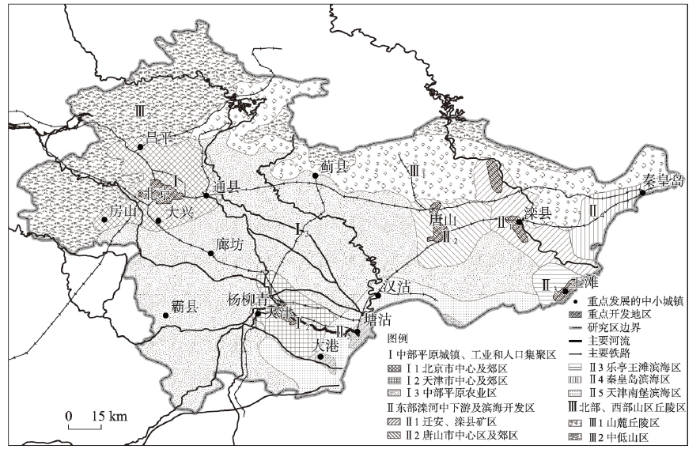
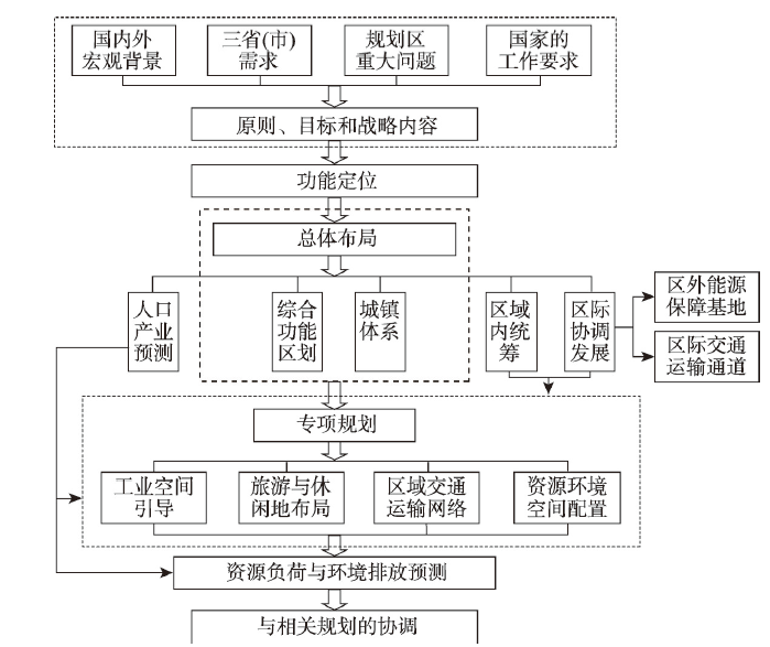
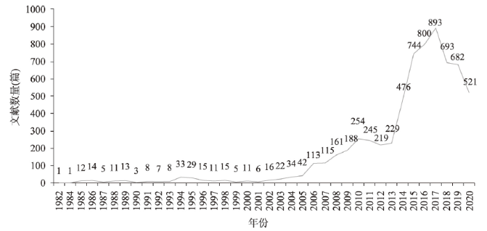

