

1 引言
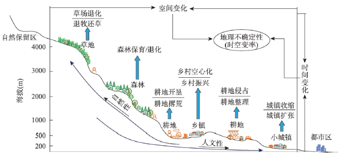
山地的存在让陆地表层空间变得更加多样化和复杂化,特别是在日益活跃的人类活动影响下,山区人文自然交互关系的时空动态性与不确定性不断增强,其交互性、耦合度存在鲜明的分异性[1-2]。在人文自然交互过程中的动态性与复合性的塑造下,山区国土空间呈现出显明的不确定性、变化性(缓变、急变)、交互性与过渡性,如城乡过渡区[3]、农牧过渡区[4]、生态过渡区[5]与地形阶梯过渡区[6]等。在这些过渡区中,山区部分的人文活动与自然景观的空间分布、过程模式与区域关联深刻地受到山区地表过程的复杂性、分异性与多样性的影响[7-8]。山区最为直观、最为基础的过渡性特征便是地形的起伏与变化,由此塑造了山地表层过程的空间分异,进而决定了地理景观的格局与分异规律。如地形梯度变化对植被垂直带谱与景观的影响[9⇓-11],山区在全球变化影响下物种与群落变化更加敏感与不稳定[12],山区也面临着比平原区更高的气候变化风险与适应的不确定性[13]。不仅如此,山区对人类活动的限制性以及人类活动对山地环境的适应性表现出明显的过渡特征。相比平原区,山区的人类活动更加受限于海拔、坡度、降水与温度的变化等[6]。如人口和经济随海拔的递减性[7-8],城镇化所带来的人口流迁对山区土地利用转型[14]、植被覆盖[15]与经济社会发展[16]产生了一系列不同于平原区的新变化和影响[17]。在时空综合维度上,山区的人地关系也因地形位的影响其地域性具有明显的多尺度分异特征[18-19],如山区乡村性与区域发展模式的空间分异性更强,其发展政策更加要求因地制宜[16]。由此可见,山区的人文自然地理交互过程表现出更为显著的时空分异性、地域性与不确定性,进而呈现为典型的过渡性地理空间。
在现代地理过程的时空演变解析中,发现人文因素的驱动性日益显著。如人文过程中的城镇化推动人口集聚,进而引发GDP增长与城镇扩张[25-26]。自然过程虽然缓慢但影响范围巨大,如全球变化下气温与降水时空波动引发森林、草原与农田等生态系统的时空变化与响应[27⇓-29]。同时,人文自然过程均集中反映在土地利用变化过程中,如建设用地扩张、耕地撂荒、退耕还林与草场退化等[30-31]。这其中,人口、植被分别是人文与自然过程中最具代表性的地理要素[31],土地利用则成为人地关系与人文自然交互过程的指示要素[32]。因此,人口、植被与土地利用的时空变化可以看作人文与自然交互过程时空动态性的综合表征要素[21,33 -34]。
图1
在国土空间研究中,过渡性地理空间作为认知山区人地关系地域性及其演变的新窗口,对其识别应基于地理不确定性的视角[1],从多维度综合定量表征人文与自然要素的时空变率。虽然已有研究对各类单一性的过渡性空间进行研究,如城乡过渡区与生态过渡区等[5,36],但针对人文自然交互下的过渡性空间综合研究仍显匮乏。因此,对山区过渡性地理空间中的人文自然交互性的量化识别与表征,及其驱动因子与分异特征的解析,已成为新时代国土空间研究的重要科学问题[1]。山区作为新时代乡村振兴战略实施的关键区域,针对山区过渡性地理空间的研究,不仅可为生态要地与珍稀自然景观保留和人地关系协调提供具有决策价值的科学依据,还有助于制定更具弹性与针对性的山区空间规划与治理政策。
2 数据与方法
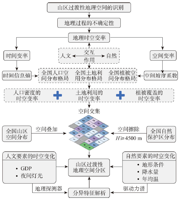
2.1 研究框架
本文遵循如下研究框架(图2):① 通过时空变率来表征地理过程的不确定性,并将地理时空变率分为时间变率与空间变率,并从人文自然交互角度选取人口密度、植被覆盖度(NDVI)分别作为人文性与自然性的正向表征指标,同时选取土地利用强度作为人文自然交互性的指示指标,土地利用强度越高,人文性越强,自然性越弱;② 采用时间信息熵与空间坡度系数分别计算所选地理要素的时间与空间变率,利用空间叠加法计算每个地理要素的时空变率指数,形成对应的空间分布图;③ 根据四等分法将各地理要素的时空变率指数的后三等分(≥ 25%)提取出来合并为地理时空变率指数,并叠加全国山区空间分布图,求取其空间交集。在此基础上,考虑到山区过渡性地理空间的人文自然复合的主体性特征,将属于纯粹自然性区域的国家自然保护区和极高山区(海拔H ≥ 4500 m)擦除,形成山区过渡性地理空间分布图;最后,根据中国自然地理区划对其进行分区,选取地形因子、降水量、年均温、GDP与夜间灯光5类指标,运用地理探测器解析各分区内关键驱动因子及其解析力,进而阐述山区过渡性地理空间的驱动力谱及其分异特征。
图2
2.2 数据来源
本文所用各类数据的时序年度、空间分辨率、格式与来源如下(表1),所有栅格数据集空间分辨率、行列号与投影坐标系均实现统一。其中2000—2015年土地利用数据来自中国科学院资源环境科学与数据中心,2020年数据来自自然资源部的Globe Land 30项目,分类标准统一为Globe Land 30的分类系统(10个一级类型);2000—2013年夜间灯光数据为DMSP影像,2014—2019年为VIIRS影像,通过归一法将VIIRS影像校正到DMSP影像辐射范围内。
表1 研究所用主要数据基本概况
Tab. 1
| 数据名称 | 年份(年度) | 空间分辨率 | 格式 | 来源 |
|---|---|---|---|---|
| 人口 | 2000—2020(21个年度) | 1 km | 栅格 | World Pop项目(www.worldpop.org) |
| NDVI | 2000—2020(21个年度) | 1 km | 栅格 | NASA的MOD13A3产品 ( |
| 土地利用 | 2000、2005、2010、 2015、2020(5个年度) | 30 m | 栅格 | 中科院资源环境科学与数据中心 ( |
| 数字高程DEM | / | 1 km | 栅格 | 中科院资源环境科学与数据中心 ( |
| GDP | 2000、2005、2010、 2015(4个年度) | 1 km | 栅格 | |
| 年均气温 | 2000—2015(16个年度) | 1 km | 栅格 | |
| 年降雨量 | 2000—2015(16个年度) | 1 km | 栅格 | |
| 夜间灯光 | 2000—2019(20个年度) | 1 km | 栅格 | NOAA的EOG项目 ( |
| 基础地理 | 2015 | 1∶100万 | 矢量 | 全国地理信息资源目录 ( |
| 山区分布 | 2000 | 1 km | 栅格 | UNEP-WCMC ( |
| 国家自然保护区 | 2018 | 1∶100万 | 矢量 | ArcGIS Online ( |
图3

图3
中国山区类型与国家自然保护区的空间分布
注:基于自然资源部标准地图服务网站GS(2019)1815号标准地图制作,底图边界无修改。
Fig. 3
Spatial distribution of the mountainous area categories and national nature reserves in China
2.3 研究方法
2.3.1 空间变率
地理要素的空间坡度体现出的是其空间变化过程。在均质空间中,地理要素的空间坡度为0,而在非均质的过渡性地理空间中,坡度随地理要素在各方向上的变化增大而增大。因此,空间坡度系数可以表征地理要素的空间变率及其过渡性与动态性,体现出空间过程中的地理不确定性。由此,本文使用空间坡度系数来测度地理要素空间变化的剧烈程度,并作为该要素的空间变率指数。计算公式如下[37]:
式中:
2.3.2 时间变率
本文利用线性回归表示时序过程,将时序上地理要素栅格相同位置的像元值归为一组样本矩阵,采用最小二乘法确定回归斜率与截距;据此计算时间点上的回归预测值,由预测值与观测值计算其样本残差及其占样本残差之和的比重(图4)。根据线性回归与信息熵的原理,观测值距离回归预测值距离越远,残差越大,地理事件的偶然性与异质性越强,其发生概率越小。
图4

图4
基于线性回归的地理要素发生概率计算示意图
Fig. 4
Calculation schematic representation of geographical events occurrence probability based on linear regression
由此,得到时序上地理事件发生概率的数学表达式如下:
在计算地理事件发生概率的基础上,根据信息熵的概念,概率越小,熵值越大,其时间变率越强。本文定义时间变率系数表达式如下:
式中:
2.3.3 地理时空变率
地理时空变率是包括人文自然多元要素的空间与时间变率,本文采用空间叠加法对时空变率进行复合,来确定山区过渡性地理空间的空间范围与地理时空变率指数。数学表达式如下:
式中:
2.3.4 土地利用强度
表2 基于Globe Land 30的土地利用强度分级指数
Tab. 2
| 强度类型 | 人工地类 | 半人工地类 | 半天然地类 | 天然地类 | |
|---|---|---|---|---|---|
| 土地利用类型 | 人造地表 | 耕地 | 林地、草地、灌木地、水域、湿地 | 苔原、裸地、冰川和永久积雪 | |
| 分级指数 | 4 | 3 | 2 | 1 | |
2.3.5 地理探测器
3 结果与分析
3.1 多元地理要素的时空变率
3.1.1 人口密度的时空变率
中国山区人口密度的时空变率整体上呈现东南高西北低的空间格局(图5a)。时空变率最高的区域主要位于江南丘陵、东北长白山等山区和山区城镇的周边,以及藏东南山区向藏北高原过渡的零星片区;山区人口密度时空变率的相对低值区主要分布在秦岭—巫山、云贵高原等山区,表明该区域人口分布的时空动态性不够明显。根据地形三大阶梯分区统计,结果显示第一、二、三阶梯人口密度时空变率均值分别为0.170、0.199和0.224,标准差分别为0.136、0.102、0.092。由此可以看出,中国东部山区人口密度的时空变率高于中西部山区,这表明山区人口的时空变率同人口密度在一定程度上呈正相关关系,即山区人口密度越高,其人口的时空动态性越强。
图5
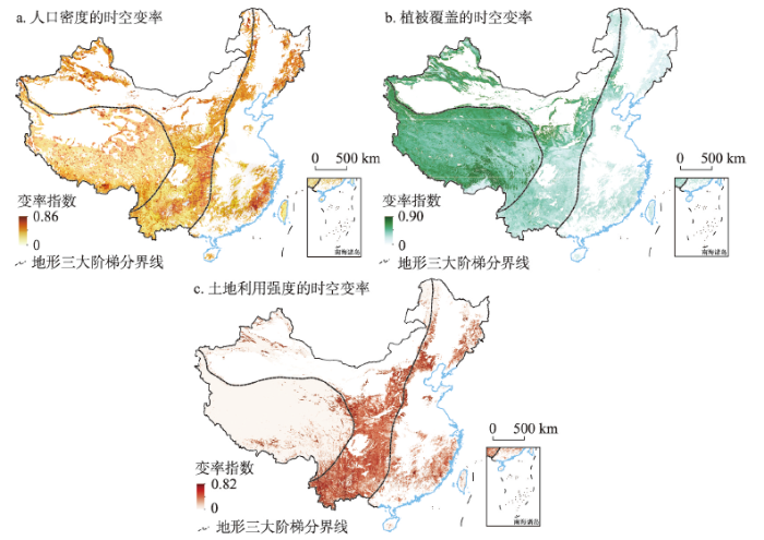
图5
中国山区人口密度、NDVI与土地利用强度的时空变率
注:基于自然资源部标准地图服务网站GS(2019)1815号标准地图制作,底图边界无修改。
Fig. 5
Spatiotemporal variability of population, NDVI and landuse intensity in mountainous areas of China
3.1.2 植被覆盖的时空变率
中国植被覆盖度(NDVI)的时空变率呈现出明显的西高东低、北高南低的趋势(图5b)。NDVI的时空变率较高的山区分布于藏东南山区、横断山区、昆仑山、天山、阴山、贺兰山与黄土高原等区域,其中藏东南山区与横断山区NDVI的时空变率最高;相较之下,长白山区、秦岭—巫山、云贵高原及东南丘陵区的NDVI时空变率相对较低,其时空动态性与分异度小于西北山区。第一、二、三阶梯山区NDVI的时空变率均值与标准差分别为0.376、0.317、0.218和0.111、0.112和0.062,这表明NDVI的时空变率明显同地形复杂度呈一定正相关关系,即地形起伏度越大,NDVI的动态性与时空格局的地理不确定性越强。
3.1.3 土地利用强度的时空变率
中国土地利用强度的时空变率呈现中间高、东西低的空间格局(图5c)。太行山—燕山、黄土高原与云贵高原等区域土地利用强度的时空变率最高,而青藏高原与西北山区除零星城镇区之外,整体较低,土地利用强度的动态性不明显。在东部山区、南方低山丘陵区及长白山部分地区其变率较高。统计第一、二、三阶梯土地利用强度时空变率均值和标准差分别为0.014、0.128、0.119和0.058、0.121、0.115,其中第二阶梯土地利用强度的动态变化度明显高于一、三阶梯。表明第二阶梯山区的土地开发利用度与干扰度的时空变率较高,域内土地利用时空格局处于快速动态变化过程中,其地理不确定性较强。
对比来看,人口密度、NDVI与土地利用强度的时空变率在三大阶梯间的空间格局是显著分异的,其分别在东部山区、西北部山区和中部山区的时空变率最为突出。三者间空间格局的宏观分异表明,单纯的人文或自然要素的时空变率无法完整地、全面地反映山区过渡性地理空间的人文自然交互性与地理不确定性,而是需要多元要素的时空变率来综合表征。
3.2 山区过渡性地理空间的识别与分类
3.2.1 人文自然交互的地理时空变率
图6
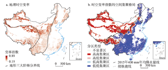
图6
中国山区过渡性地理空间的地理时空变率及其空间格局
注:基于自然资源部标准地图服务网站GS(2019)1815号的标准地图制作,底图边界无修改。
Fig. 6
The geographical spatiotemporal variability and its spatial pattern of MTGs in China
就山区过渡性地理空间的地理时空变率而言,总体上呈现西北高东南低的格局(图6a),地理时空变率较高的山区主要分布在天山、昆仑山—祁连山、黄土高原、太行山以及藏东南山区,而在秦岭、巫山、云贵高原等山区城镇周边与东南丘陵山区存在地理时空变率局部高值区;相比之下,南岭山区、秦岭腹地、横断山区西北部和云贵高原中南部的地理时空变率相对较低。分阶梯对山区地理时空变率进行统计,第一、二、三阶梯均值和标准差分别为0.369、0.336、0.295和0.080、0.081和0.056,可以看出,山区地理时空变率从第一阶梯到第三阶梯呈逐渐递减趋势。对山区地理时空变率进行空间自相关分析,全局莫兰指数为0.640(p ≤ 0.01),表明存在显著的正向空间集聚性;局部空间自相关分析显示(图6b),山区地理时空变率高值区集聚于西北部山区和藏东南山区,东南部山区相对较低,这种空间分异性大致与400 mm等降水量线吻合,即与胡焕庸线的空间格局相一致,表明自然地理分异对山区过渡性地理空间人文自然交互性时空格局的根本性塑造作用。
3.2.2 山区过渡性地理空间的分区
针对山区过渡性地理空间显著的分异性,本文在三大地形格局的基础上,结合地貌分区[42]、山地空间范围[43]、主要山脉与山峰位置[44]和人文地理综合区划[45],将中国山区过渡性地理空间分为12个分区(图7)。比较而言,本文分区与自然地域分区、人文地理分区等综合区划不同的是,分区方案主要针对山区过渡性地理空间的识别,并不完全覆盖全国山地或全国国土范围,更加强调与社会经济发展的关联。在分区方案中,地形格局与山区分布是首要考量因素,并兼顾地貌大区、植被类型区和人文地理大区的分布,突出人文自然复合特色,是对山区过渡性地理空间地域性特征的基本把握。在12个山区过渡性地理空间分区中,昆仑—祁连山分区面积最大,其次为天山—阿尔泰山分区,而内蒙古与宁夏的阴山—贺兰山分区面积最小,仅为昆仑—祁连山分区的九分之一,表明不同区域山区过渡性地理空间的分布差异性很大。
图7
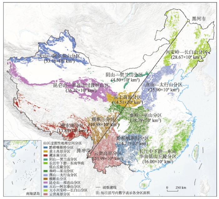
图7
中国山区过渡性地理空间的12个分区
注:基于自然资源部标准地图服务网站GS(2019)1815号的标准地图制作,底图边界无修改。
Fig. 7
The spatial divisions of mountainous transitional geospace (MTG) in China
统计各分区的地理时空变率及人口、NDVI与土地利用强度的时空变率指数(图8),可以发现昆仑—祁连山分区的地理时空变率最高,均值达到0.399,其次为天山—阿尔泰山分区、藏东南分区、阴山—贺兰山分区,变率均值都在0.370以上。南方山区过渡性地理空间均值较低,其中黔桂喀斯特分区均值最低,仅为0.269;在人口密度的时空变率方面,均值最高的是阴山—贺兰山分区,均值最低的是云贵高原分区,但在各分区间差异较小,表明全国山区人口的时空过程是趋同的;在NDVI方面,北方大部山区过渡性地理空间的NDVI时空变率明显高于南方山区,表明北方山区NDVI的时空动态度与不确定性高于南方,更容易受到人类活动与气候变化的影响;在表征人文自然交互性的土地利用强度时空变率上,均值最高的是燕山—太行山分区,均值最低的则是昆仑—祁连山分区。在空间格局上,南方山区和北方的燕山—太行山与黄土高原分区的均值明显大于西北山区过渡性地理空间,这显示出在人类活动影响下,这部分山区在人文自然交互关系上具有更高的动态性。
图8
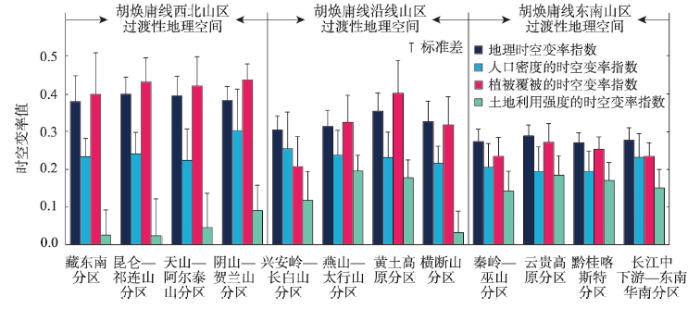
图8
不同分区的地理时空变率指数均值与标准差
Fig. 8
Mean and SD of geographical spatiotemporal variability index in each division of MTGs
对比各分区间的时空变率指数,可发现NDVI时空变率指数的分异性最强,其标准差达到0.087,其次是土地利用强度时空变率指数(0.067)与综合性的地理时空变率指数(0.049),最低的是人口密度的时空变率指数(0.029)。表明NDVI与土地利用强度在塑造山区地理不确定性的空间分异格局上起着主导作用,自然地理格局的塑造力总体是大于人文驱动力的。以胡焕庸线为界将各分区分为3类,并统计其各类时空变率指数。胡焕庸线西北山区过渡性地理空间在地理时空变率、人口与NDVI的时空变率指数上均明显大于胡焕庸线沿线与东南山区过渡性地理空间,自西北向东南呈递减趋势,其中NDVI的递减趋势更为显著。而在土地利用强度的时空变率上,呈现出自胡焕庸线东南向西北递减的趋势(0.162 > 0.130 > 0.046)。同时,NDVI与土地利用强度的时空变率在不同分区之间具有显著的负相关关系(r = -0.536,p ≤ 0.01)。表明NDVI不确定性较高的区域内土地利用强度相对稳定,而在NDVI时空动态相对稳定的山区,其土地利用强度却处在快速变化中。
3.3 山区过渡性地理空间的分异特征
3.3.1 山区过渡性地理空间驱动因子的选择
本文针对山区过渡性地理空间所呈现出来的人文自然交互性与区域分异性,从静态塑造与时空动态驱动两个视角分别选择基础地形、人文与自然驱动3类12个地理因子予以解析(表3)。① 将山区过渡性地理空间的地理时空变率及人口密度、NDVI与土地利用强度的时空变率4个指数作为待解析的因变量;② 将海拔、坡度、地形起伏度[7]与地形位指数[19](窗口为100 km2)作为基础地形因子,表征基础地理格局的静态塑造作用;利用变异系数和栅格坡度分析法,分别计算出GDP、夜间灯光、年降水量和年均温的时间变化性系数与空间坡度(多年均值)的空间栅格数值,得到表征人文和自然要素的时间变化性与空间分异性的8个因子;③ 建立起覆盖全国的蜂窝格网(考虑到计算量与栅格像元大小及噪声值,每个格网面积为100 km2),逐格网提取山区过渡性地理空间的各类变率指数及各因子栅格的均值,得到包括4个因变量与12个自变量的山区过渡性地理空间时空变率值及解析因子的数据集,以此作为地理探测器的输入数据。
表3 山区过渡性地理空间地理不确定性解析驱动因子的选择
Tab. 3
| 类别 | 名称 | 数据类型 | 变量符号 | |
|---|---|---|---|---|
| 因变量 | 山区过渡性地理空间的地理变率 | 空间栅格(1 km) | En_Mountain | |
| 山区过渡性地理空间人口时空变率 | 空间栅格(1 km) | En_Pop | ||
| 山区过渡性地理空间NDVI时空变率 | 空间栅格(1 km) | En_NDVI | ||
| 山区过渡性地理空间土地利用强度时空变率 | 空间栅格(1 km) | En_Land | ||
| 静态塑造 因子 | 基础地理 | 海拔 | 空间栅格(1 km) | DEM |
| 地形起伏度 | 空间栅格(1 km) | DEM_Relief | ||
| 地形坡度 | 空间栅格(1 km) | DEM_Slope | ||
| 地形位指数 | 空间栅格(1 km) | Topography_Index | ||
| 动态驱动 因子 | 人文驱动 | GDP时间变化性 | 空间栅格(1 km) | CV_GDP |
| 夜间灯光时间变化性 | 空间栅格(1 km) | CV_Night | ||
| GDP空间分异性 | 空间栅格(1 km) | Slope_GDP | ||
| 夜间灯光空间分异性 | 空间栅格(1 km) | Slope_Night | ||
| 自然驱动 | 年降水量时间变化性 | 空间栅格(1 km) | CV_Per | |
| 年均温时间变化性 | 空间栅格(1 km) | CV_Tem | ||
| 年降水量空间分异性 | 空间栅格(1 km) | Slope_Per | ||
| 年均温空间分异性 | 空间栅格(1 km) | Slope_Tem | ||
3.3.2 山区过渡性地理空间的整体驱动力谱
基于地理探测器得到基础地形因子与人文自然时空驱动因子对各类变率指数的解析力及其显著性(表4)。可以发现,基础地形因子与人文自然时空驱动因子均对土地利用强度的时空变率解析力最强(平均解析力0.125),且显著性最高。相较之下,人文自然驱动类因子对地理时空变率与人口时空变率的解析力较低。横向对比来看,空间驱动因子对各类变率指数的解析力最高(0.089),且显著高于时间驱动因子(0.077)与基础地形因子(0.078),尤其是在对人口与土地利用的时空变率解析上。对比各类别因子的平均解析力,可以发现,人文驱动因子对人口与土地利用的时空变率解析力最强,尤其是对人口密度时空变率的解析。在对综合指数地理时空变率的解析方面,基础地形因子的解析力大于人文自然驱动因子,但三者间的差距很小。
表4 各因子对山区过渡性地理空间各类变率指数的解析力
Tab. 4
| 因子 | 基础地形因子 | 时间驱动因子 | 空间驱动因子 | Mean | |||||||||||
|---|---|---|---|---|---|---|---|---|---|---|---|---|---|---|---|
| DEM | DEM _Relief | DEM _Slope | Topography Index | CV_ GDP | CV_ Night | CV_ Per | CV_ Tem | Slope _GDP | Slope _Night | Slope _Per | Slope _Tem | ||||
| En_Mountain | 0.084* | 0.047* | 0.055* | 0.033 | 0.041 | 0.058* | 0.046 | 0.065* | 0.036 | 0.079* | 0.050* | 0.048 | 0.054 | ||
| En_Pop | 0.049* | 0.038 | 0.049* | 0.038 | 0.020 | 0.131* | 0.028 | 0.019 | 0.071* | 0.192* | 0.038 | 0.040* | 0.059 | ||
| En_NDVI | 0.186* | 0.071* | 0.076* | 0.061* | 0.069* | 0.062* | 0.059* | 0.105* | 0.058* | 0.087* | 0.065* | 0.065* | 0.080 | ||
| En_Land | 0.185* | 0.093* | 0.101* | 0.081* | 0.156* | 0.143* | 0.014 | 0.139* | 0.168* | 0.234* | 0.092* | 0.094* | 0.125 | ||
| Mean | 0.126 | 0.062 | 0.070 | 0.053 | 0.072 | 0.099 | 0.037 | 0.082 | 0.083 | 0.148 | 0.061 | 0.062 | / | ||
注:*表示解析力在0.01水平上统计显著。
分类来看(表4),海拔对综合指数地理变率的解析力最强,时间驱动因子对其解析力最弱,这表明山区过渡性地理空间在地理时空变率上,受到基础地形因子的塑造力更强,并在空间过程上的动态性高于时间过程;对人口的时空变率而言,夜间灯光时间变化性(CV_Nigh)对其解析力最强,且远高于其他因子,这显示出人文经济活动对山区人口的时空动态性具有极强的驱动力;对NDVI时空变率解析力最强的因子为海拔,此外其余因子均对其具有显著解析力,且各因子解析力差异较小,这说明基础地形、人文经济活动与气候变化均对山区NDVI的时空动态具有显著影响,且地形仍是决定性要素;在土地利用时空变率方面,夜间灯光时间变化性(CV_Nigh)具有最强解析力,且人文要素的时空驱动因子及地形因子均对其表现出显著的解析力。除年降水量时间变化性(CV_Per)外,其余因子对土地利用时空变率解析力均较显著,且明显高于对另三类变率指数的解析力。表明土地利用强度的时空变率成为山区过渡性地理空间地理不确定性的主要表现形式,人文自然要素的时空动态变化通过驱动土地利用强度的时空演变,进而作用于山区过渡性地理空间人地关系的时空演变过程。
3.3.3 山区过渡性地理空间的分区驱动力谱
在基础地形因子方面(图9a~9d),海拔在藏东南分区、横断山分区和秦岭—巫山分区对NDVI与土地利用强度的时空变率解析力较高,而在阴山—贺兰山分区解析力较低;地形起伏度与坡度均在在燕山—太行山分区、云贵高原分区与长江中下游—东南华南低山丘陵区的解析力较高;而地形位指数则在长江中下游—东南华南低山丘陵分区具有较高解析力,尤其是对NDVI与土地利用强度的时空变率解析上。整体上,基础地形因子中,海拔在各分区的解析力最高,而地形起伏度、坡度与地形位指数仅在部分地形较为破碎的分区对NDVI与土地利用强度的时空变率具有较高解析力。表明海拔是塑造山区整体过渡性的关键因子,而在地形破碎化的山区,NDVI与土地利用强度的时空动态性受各类地形指数的显著影响,山区局域地形越破碎与复杂,其NDVI与土地利用强度的不确定性特征越明显。
图9
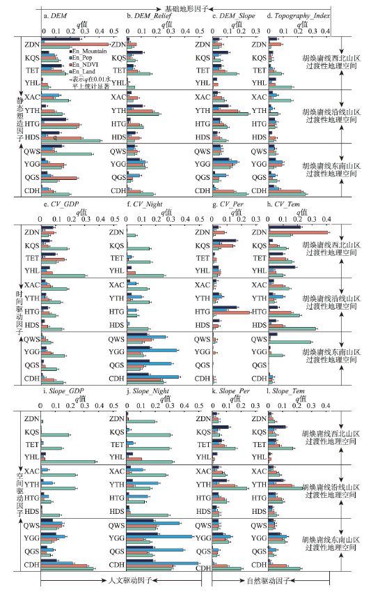
图9
不同山区过渡性地理空间的驱动力谱
注:藏东南分区(ZDN)、昆仑—祁连山分区(KQS)、天山—阿尔泰山分区(TET)、阴山—贺兰山分区(YHL)、兴安岭—长白山分区(XAC)、燕山—太行山分区(YTH)、黄土高原分区(HTG)、横断山分区(HDS)、秦岭—巫山分区(QWS)、云贵高原分区(YGG)、黔桂喀斯特分区(QGS)、长江中下游—东南华南低山丘陵分区(CDH)。
Fig. 9
The driving forces spectrum of humanistic and natural factors in each division of MTGs
在时间驱动因子中(图9e~9h),除GDP时间变化性(CV_GDP)之外,其余因子在各分区的解析力均有明显的分异性。具体来看,GDP时间变化性(CV_GDP)在各分区对土地利用强度时空变率具有较高解析力,尤其是在阴山—贺兰山分区。而在天山—阿尔泰山分区则对NDVI时空变率解析力最高,表明这些山区经济活动对土地利用强度与NDVI时空变化的影响很敏感;夜间灯光时间变化性(CV_Night)在胡焕庸线东南山区过渡性地理空间对各类变率指数的解析力明显高于胡焕庸线沿线及西北山区过渡性地理空间,尤其是在胡焕庸线东南侧对人口密度时空变率具有极高解析力,这显示出人文要素时间变化对胡焕庸线东南山区过渡性的巨大驱动力,并深刻影响了这类山区过渡性地理空间人文自然交互性的时空演变。值得注意的是,夜间灯光时间变化性(CV_Night)在胡焕庸线西北山区过渡性地理空间仅对土地利用时空变率具有较高解析力,这反映出西北山区过渡性地理空间的土地利用变化在人文活动下具有高度地理不确定性与明显的过渡性;不同的是,自然要素的时间变化因子年降水量时间变化性(CV_Per)和年均温时间变化性(CV_Tem)在胡焕庸线沿线与西北山区过渡性地理空间的解析力明显高于东南山区过渡性地理空间,尤其是年均温时间变化性(CV_Tem)在藏东南分区、黄土高原分区、横断山分区与秦岭—巫山等分区具有较高解析力。从变率类别来看,年降水量时间变化性(CV_Per)和年均温时间变化性(CV_Tem)主要对地理时空变率、NDVI与土地利用强度的时空变率解析力较高,而对人口时空变率的解析力微弱。这说明气温与降水的时间变化主要驱动NDVI与土地利用强度的时空动态演变,且这种影响主要集中于中国气候类型区分界处的山区与西北山区,揭示出这类山区过渡性地理空间对气候变化的敏感性。
在空间驱动因子中(图9i~9l),人文类因子在各分区间解析力的分异性强于自然类因子。具体而言,GDP空间分异性(Slope_GDP)与夜间灯光空间分异性(Slope_Night)在胡焕庸线东南山区过渡性地理空间对各类时空变率指数具有更大的解析力,其中夜间灯光空间分异性(Slope_Night)对地理时空变率、人口与NDVI的时空变率解析力远高于胡焕庸线沿线与西北山区过渡性地理空间,即人文要素对中国东南山区过渡性地理空间人文自然交互性的驱动作用大于西北山区过渡性地理空间。然而,GDP空间分异性(Slope_GDP)与夜间灯光空间分异性(Slope_Night)在胡焕庸线沿线与西北山区过渡性地理空间对土地利用的时空变率具有较高解析力,这说明人文活动的空间分异性对西北山区过渡性地理空间的土地利用变化影响显著;自然因子方面,年降水量空间分异性(Slope_Per)和年均温空间分异性(Slope_Tem)对天山—阿尔泰山分区、燕山—太行山分区与长江中下游—东南华南低山丘陵分区的NDVI与土地利用强度的时空变率具有一定解析力。但从整体而言,自然因子的空间分异性对各类变率指数的解析力相对较小且在各分区间变化不大,即自然要素的空间分异性对山区过渡性地理空间动态演变的驱动作用总体上弱于人文要素。
综上可见,海拔与夜间灯光空间分异性(Slope_Night)是大多数山区过渡性地理空间解析力最大的因子。对人口与土地利用时空变率指数而言,6个分区中,夜间灯光空间分异性(Slope_Night)是其解析力最大的因子。由此可见,基础地形塑造与人文活动是山区过渡性地理空间人文自然交互演变的关键主导因子与主要驱动力。整体上,各因子在云贵高原分区对综合指数地理时空变率和人口时空变率指数的平均解析力最高(0.080, 0.140),在长江中下游—东南华南低山丘陵分区,各因子对NDVI与土地利用的时空变率指数平均解析力最高(0.147, 0.199)。
4 结论与讨论
4.1 结论
本文遵循地理不确定性的概念,构建了地理时空变率指数,以人口密度、植被覆盖与土地利用强度作为人文自然交互的表征指标,识别出中国山区过渡性地理空间地域特征与分布格局,对其进行分区,并运用地理探测器从基础地形、人文自然驱动的角度探测各因子对其地理时空变率的解析力,进而阐释山区过渡性地理空间人文自然交互性的驱动力谱和分异特征。主要结论如下:
(1)中国山区过渡性地理空间是极为重要的国土空间,也是空间高质量发展与人地关系协调的关键区域,其总面积为238.32×10⁴ km2(约占全国陆表面积的24.83%),主要分布于中西部山区,其中过渡性特征最明显的山区过渡性地理空间分布于天山、昆仑—祁连山、黄土高原与太行山等地。山区过渡性地理空间的时空变率从第一阶梯到第三阶梯呈递减趋势,即东南山区过渡性地理空间的不确定性低于西北山区。
(2)中国山区过渡性地理空间可分为12个分区。其中昆仑—祁连山分区面积最大,阴山—贺兰山分区面积最小。相较而言,NDVI时空变率指数在各分区间的分异性最大,其次是土地利用强度时空变率指数,而人口密度的时空变率指数分异性相对较小,表明NDVI与土地利用强度在塑造山区过渡性地理空间不确定性的分异格局上起着主导作用,自然地理格局的塑造力总体上大于人文力。
(3)从静态塑造与时空动态驱动的视角解析山区过渡性地理空间的驱动力谱,发现人文驱动因子对人口与土地利用的时空变率解析力最强,基础地形因子对NDVI时空变率与综合指数地理时空变率指数的解析力最强;在不同指数间,各因子对土地利用强度的时空变率均具有最强解析力;在不同因子间,海拔是塑造山区过渡性地理空间的关键因子,而夜间灯光空间分异性对山区过渡性地理空间具有很强的表证性。
(4)不同类别因子对山区过渡性地理空间的塑造性分异明显。基础地形因子对破碎化山区的地理时空变率解析力更高;人文要素的时间与空间动态过程对东南山区过渡性地理空间的解析力最强;气温与降水的时间变化性和人文活动的空间分异性对西北山区过渡性地理空间的驱动力最高,但后者主要作用于土地利用强度的地理不确定性上。
4.2 讨论
本文重在刻画人文自然要素交互与时空动态过程下的山区过渡性地理空间特性,有益于促进过渡性地理空间研究从单一性与静态性向交互性与时空动态性发展。在理论上,基于时空变率指数的山区过渡性地理空间识别与表征,能够有机地将多元人文自然要素的地理不确定性编码到区域特征的识别、量值表征与区划中,这对于从人文自然交互视角认知人地关系的关联性、嵌套性及其系统性与综合性具有重要科学意义;在方法上,最具探索的是,本文尝试将线性回归引入到地理要素的时间过程模拟中,并用回归残差来表示地理要素时间过程中的波动性与不确定性,将此作为地理要素的发生概率,这进而为观测与模拟地理要素时间过程的平稳性与可预测性提供了参量。相比于使用固定均值与期望[46],本文所构建的方法将地理要素的期望视为随时间而变化的函数过程,这可以更好地模拟变化环境中人文自然要素宏观趋势之下的变异性与不确定性;在模型上,本文同时引入坡度系数与时间信息熵,基于时空变率的视角定量表征了地理过程的不确定性,将地理变化转换为地理过程,从而实现将多元要素的时空动态性编码到区域特性的表达中,这对研究山区地理空间的不确定性、弹性与稳定性、多样性与复杂性提供了定量分析工具。
山区过渡性地理空间作为国土空间中人地关系敏感性、复杂性与不确定性突出的区域,对其格局与过程的研究还需进一步加深。在指示要素选择上,本文仅选用人口、植被与土地利用3个典型表征要素予以刻画,而表征复杂人文活动与变化环境的人文自然要素也应纳入到研究框架中,以提高交互性识别与过渡性刻画的指示性与综合性;在时间尺度上,时空动态性是识别与表征过渡性与不确定性的关键路径,更长时间序列的数据有助于提升模型拟合的稳健性,且不同时间序列及未来情景下时空动态研究对于山区过渡性地理空间的识别与表征、时空演变、动态模拟至关重要,有利于认知山区过渡性地理空间的演变规律与人文自然复合机理;在空间尺度上,过渡性地理空间具有尺度依赖性,尤其是在山区。不同尺度下的过渡性地理空间具有关联性与嵌套性,其间的级联效应能够较好地指示国土空间功能的传递性及功能传递间的刚性约束与弹性权衡;在模型方法上,多元地理数据的复合应是未来模型改进的重要方向。在大区域研究中,为体现区域人文自然复合的分异性,不同区域内多元地理数据的复合权重应有所不同;在新型城镇化和乡村振兴背景下,山区过渡性地理空间的高质量发展面临诸多挑战,空间权衡问题复杂,人地关系协调难度大。因此,科学而深入地解析和认知这一特殊的国土空间本质与演变规律及人文自然交互机理亟待加强,这不仅可为区域地理学综合研究提供新的探索方向,其研究成果还可为山区国土空间开发格局的优化、促进其可持续发展提供科学认知与决策依据。
参考文献
Transitional geospace from the perspective of human-nature coupling: Concept, connotations, attributes, and the research framework
人文自然耦合视角下过渡性地理空间概念、内涵与属性和研究框架
DOI:10.11821/dlyj020200189
[本文引用: 4]

从人文自然耦合的视角看,过渡性地理空间是介于自然和人文之间的复合地带,凸显人地关系地域系统的特殊性与复杂性。其中,山区是过渡性地理空间的主体,是全国国土空间高质量发展与治理的关键区域,对其系统深刻理解与认知亟待全面加强。立足于人文自然耦合系统层面阐释过渡性地理空间的概念、内涵与属性,并借鉴多学科理论与方法,结合地理编解码技术,探索性提出基于色差渐变原理的过渡性地理空间研究的科学框架,以期深刻阐释过渡性地理空间人文自然耦合演化过程及其机理,并为提升过渡性地理空间国土空间功能与优化国土空间开发格局提供科学指导和决策依据,这对于丰富人地关系地域系统研究做出新的探索具有应用价值。
Urban-rural-natural gradient analysis with CORINE data: An application to the metropolitan France
DOI:10.1016/j.landurbplan.2017.11.005 URL [本文引用: 1]
The determination of urban-rural ecotones from the perspective of urban and rural landscape complexity
城乡景观复杂度视角下的城乡交错带界限确定: 以武汉市为例
Progress and perspective of agro-pasturage ecotone
农牧交错带研究进展
Spatial identification and scenario simulation of ecotone distribution in China
DOI:10.11821/dlxb202103010
[本文引用: 2]
Explicitly identifying the ecotone distribution and scenario change is of important significance to understand the response of ecosystem to climatic change. In this paper, a spatial identification method was developed to analyze the ecotone distribution in terms of the improved Holdridge life zone (iHLZ) model. Based on the climatic observation data of 782 weather stations of China in the T0 (1981-2010) period, and the climatic scenario data of IPCC CMIP5 RCP2.6, RCP4.5 and RCP8.5 in T1 (2011-2040), T2 (2041-2070) and T3 (2071-2100), the ecotones distribution and scenarios in China were simulated in the four periods. Moreover, a spatial shift trend model of mean center was introduced to quantitatively calculate the shift direction and distance of each ecotone type during the periods from T0 to T3. The simulated results show that there are 41 ecotone types in China, accounting for 18% of the total land area of China. The ecotones of cold temperate grassland / humid forest and warm temperate arid forest (564238.5 km2), cold temperate humid forest and warm temperate arid / humid forest (566549.75 km2), and northern humid / humid forest and cold temperate humid forest (525750.25 km2) are the main ecotone types, accounting for 35% of the total area of ecotones in China. Between T0 and T3, the area in the ecotone of cold temperate desert shrub and warm temperate desert shrub / thorn steppe will increase at a rate of 4% per decade, which is up by 3604.2, 10063.1 and 17242 km2 per decade under the RCP2.6, RCP4.5 and RCP8.5 scenarios, respectively. The cold ecotones will transform to the warm humid ecotones in the future. The average shift distance of mean center in the ecotone of north wet forest and cold temperate desert shrub / thorn grassland will be generally larger than that of other ecotones, whose mean center will move to the northeast, and the shift distance will be more than 150 km between T0 and T3. In addition, with a gradual increase of temperature and precipitation, the ecotones in northern China will show a shifting northward trend, while the ecotones in southern China will decrease gradually, and their mean center move to the high-altitude areas. The effects of climate change on ecotones will show an increasing trend in China, especially in the Qinghai-Tibet Plateau.
中国生态过渡带分布的空间识别及情景模拟
DOI:10.11821/dlxb202103010
[本文引用: 2]
在全球变化及其生态环境效应研究中,如何对生态过渡带的空间分布格局及变化情景进行空间定量识别和模拟分析,对揭示气候变化和人类活动对全球变化的响应及反馈具有指示性意义。在对HLZ模型进行修正和拓展的基础上,建立了生态过渡带类型的空间识别方法。并基于1981—2010年的全国782个气候观测站点数据,在实现全国生态过渡带类型及分布的空间识别基础上,结合3种气候情景数据CMIP5 RCP 2.6、RCP 4.5和RCP 8.5,实现了T0(1981—2010年)、T1(2011—2040年)、T2(2041—2070年)和T3(2071—2100年)4个时段内全国生态过渡带的空间分布格局及其未来情景模拟。另外,引入平均中心空间分析模型,对全国生态过渡带平均中心的时空偏移趋势进行了定量分析。结果显示:在T0~T3时段内,全国共出现41种生态过渡带类型,约占全国陆地面积的18%;冷温带草原/湿润森林与暖温带干旱森林过渡带(564238.5 km<sup>2</sup>)、冷温带湿润森林与暖温带干旱/湿润森林过渡带(566549.75 m<sup>2</sup>)、北方湿润/潮湿森林与冷温带湿润森林过渡带(525750.25 km<sup>2</sup>)是最主要的3种生态过渡带类型。面积占到全国生态过渡带总面积的35%;2010—2100年期间的冷温带荒漠灌丛与暖温带荒漠灌丛/有刺草原过渡带的增加速度最快,在3种情景RCP 2.6、RCP 4.5和RCP 8.5下,其面积将分别增加3604.2 km<sup>2</sup>/10a、10063.1 km<sup>2</sup>/10a和17242 km<sup>2</sup>/10a;寒冷型生态过渡带类型总体上呈向暖湿型过渡带类型增加的趋势;北方潮湿森林与冷温带湿润/潮湿森林过渡带的平均中心偏移幅度最大,在4个时段内整体向东北方向偏移,其偏移幅度将超过150 km。另外,随着气温的逐渐上升和降水量的增加,中国北方的生态过渡带整体呈向北偏移趋势,南方生态过渡带则逐渐减少且平均中心呈现逐渐向高海拔地区退缩的趋势,气候变化对青藏高原区生态过渡带时空格局的影响日益显著。
Spatial variations of terrain and their impacts on landscape patterns in the transition zone from mountains to plains: A case study of Qihe River basin in the Taihang Mountains
山地平原过渡带地形起伏特征及其对景观格局的影响: 以太行山淇河流域为例
Population-economy spatial pattern and impact mechanism of the Qinba mountain area based on topographic factors
DOI:10.13249/j.cnki.sgs.2020.05.014
[本文引用: 3]
Topography is an important factor affecting regional population distribution and social and economic development, and its influence and restraint effect is more obvious especially in mountainous areas. This study takes Qinba Mountain area as an example to analyze the pattern and differentiation characteristics of population and economic space on multiple scales with the help of a variety of spatial analysis and geostatistics methods. Based on 90 m resolution SRTM data, it extracts elevation and relief amplitude, with an emphasis on quantitatively revealing the relationship and influence degree between terrain and environmental elements and the population and economic space. The results show that: 1) The population, village and economic density of Qinba Mountain area show a significant differentiation. The results of Lorenz curve and Gini coefficient show that the population distribution is unbalanced, but the unbalance degree is lower than the national level. Besides, the results of Moran's index show that population and economic space have certain agglomerating characteristics, and the degree of agglomeration is more obvious at the cell scale. 2) The density of population and GDP shows the spatial pattern of external heat and internal cooling, and it is found that the differentiation of population and economic factors in the vertical direction is obvious through the analysis of spatial element density in the cell scale. 3) The change curve of the density of population and GDP and elevation in sample belt research show a reverse correlated relationship, and the population and economy have a certain adaptability to terrain in small scale range. 4) Economic development is more dependent on terrain conditions, and the adaptability of population and villages to topography is more obvious; the vertical differentiation of topography leads to the spatial difference of natural environment and regional development conditions, and then affects the spatial distribution pattern of population and economy.
基于地形因素的秦巴山区人口: 经济空间格局及其影响机制研究
DOI:10.13249/j.cnki.sgs.2020.05.014
[本文引用: 3]
地形是影响区域人口分布和社会经济发展的重要因素,尤其在山地区域其影响和约束作用更加明显。以秦巴山区为例,基于SRTM数据提取高程和地形起伏度,借助多种空间分析和地统计学方法,分多个尺度对人口、经济空间的格局和分异特征进行分析,重点从地形要素定量揭示其与人口、经济空间的相互关系和影响程度。研究表明:① 秦巴山区人口经济空间分异特征明显,Lorenz曲线和基尼系数结果显示,人口分布具有不均衡性,但不均衡程度低于全国水平,Moran's I指数结果说明人口、经济空间具有一定集聚特征,且在像元尺度下集聚程度更明显;②人口、GDP密度呈现外围热、内部冷的空间格局,通过像元尺度的空间要素密度分析发现人口、经济要素在垂直方向上的分异十分明显;③ 样带研究中人口、GDP密度与海拔的变化曲线呈反向相关,人口、经济在小尺度范围对地形有一定的适应性;④ 经济发展对地形条件依赖性更强,人口和村庄对地形的适应性更加明显;地形的垂直分异特征导致自然环境和区域发展条件的空间差异,进而影响着人口、经济的空间分布格局。
The relief degree of land surface in China and its correlation with population distribution
中国地形起伏度及其与人口分布的相关性
Spatial distribution patterns of Pinus tabulaeformis forest and Pinus massoniana forest in Qinling-Daba Mountains and the boundary of subtropical and warm temperate zones
DOI:10.11821/dlxb202011002
[本文引用: 1]
Qinling Mountains is not only the geographical boundary between North and South China, but also the boundary between subtropical and warm temperate zones. It plays an important role in the geo-ecological pattern of China. However, there is controversy about the specific location of this geographical boundary in academic community due to the complexity, transition and heterogeneity of the transitional zone, as well as the differences in the delimitation indicators and research purposes. To further reveal the characteristics of the North-South transitional zone and clarify the specific location of the geo-ecological boundary between North and South China, combined with SRTM topographic data, temperature and precipitation data, Pinus massoniana forest and Pinus tabulaeformis forest, which represent subtropical coniferous forests in South China and temperate coniferous forest in North China respectively, were chosen to analyze their spatial distributions in the Qinling-Daba Mountains and the climatic conditions at their boundary with the climatic indexes of annual precipitation, the coldest month (January) average temperature, the warmest month (July) average temperature and the annual average temperatures. The results show that: (1) Pinus massoniana and Pinus tabulaeformis forests and the climate indicators of their boundary can be used as one of the vegetation-climate indicators for the delimitation of subtropical and warm temperate zones. The boundary between the subtropical coniferous forest (Pinus massoniana forest) and temperate coniferous forest (Pinus tabulaeformis forest) in Qinling-Daba Mountains is located along the south slope of Funiu Mountain to the north edge of Hanzhong Basin (the south slope of Qinling Mountains) at an altitude of 1000-1200 m, where the climatic indictors are stable: the annual precipitation is about 750-1000 mm; the annual average temperature is about 12-14 ℃; the coldest monthly average temperature is 0-4 ℃; and the warmest monthly average temperature is about 22-26 ℃. (2) It could be more scientifically to delimitate the boundary of subtropical and warm temperate zones in China by comprehensively considering the vegetation-climate indicators. Additionally, the boundary between subtropical and warm temperate zones in Qinling-Daba Mountains should be a transitional zone consisting of the boundaries of coniferous forests, broad-leaved forests and shrubs between subtropical and warm temperate zones. The results provide a scientific basis for the selection of delimitation indicators of subtropical and warm temperate zones.
秦巴山区马尾松林和油松林的空间分布及亚热带与暖温带界线划分
DOI:10.11821/dlxb202011002
[本文引用: 1]
秦岭不仅是中国南北的地理分界线,也是中国亚热带和暖温带的气候分界线,在中国地理生态格局中占有重要的地位和作用。由于过渡带的复杂性、过渡性和异质性以及划分指标、研究目的的不同,学术界关于这一南北地理—生态分界线的具体位置一直有争论。为了进一步揭示秦巴山区过渡带的特征,明确中国南北地理—生态分界线的位置,本文选择马尾松(Pinus massoniana)林和油松(Pinus tabulaeformis)林这两类分别代表中国南方亚热带针叶林和北方温带针叶林的植被,结合研究区SRTM地形数据、气温和降水数据等,以年降水、最冷月(1月)气温、最热月(7月)气温和年均温为气候指标,详细分析了这两类植被在秦巴山区的空间分布及二者分界线处的气候条件。结果表明:① 马尾松林和油松林的分界线及相应位置的气候指标可以作为亚热带与暖温带界线划分的植被—气候指标之一。秦巴山区亚热带针叶林(马尾松林)与温带针叶林(油松林)的分界线位于伏牛山南坡至汉中盆地北缘一线(秦岭南坡)海拔1000~1200 m处;分界线处气候指标稳定:年降水750~1000 mm,年均温12~14 ℃,最冷月气温0~4 ℃,最热月气温22~26 ℃。② 通过综合的植被—气候指标来划分秦巴山区亚热带和暖温带的界线,能更科学地确定气候带分界线的位置及过渡带的特征,更全面地反映地表植被—气候格局的变化。此外,秦巴山区亚热带与暖温带的界线应该是由亚热带与暖温带针叶林分界线、阔叶林分界线、灌丛分界线等组成的一个过渡带。本文的研究结果为亚热带与暖温带划分指标的选取提供了一定的科学依据。
Assessment of spatio-temporal variations in vegetation cover in Xinjiang from 1982 to 2013 based on GIMMS-NDVI
1982-2013年基于GIMMS-NDVI的新疆植被覆盖时空变化
Gradient effects and ecological zoning of ecosystem services in transition zone of Beijing Bay
北京湾过渡带生态系统服务梯度效应分析及生态分区
Predicting species and community responses to global change using structured expert judgement: An Australian mountain ecosystems case study
DOI:10.1111/gcb.15750 URL [本文引用: 1]
High land-use intensity diminishes stability of forage provision of mountain pastures under future climate variability
Effect of rural ageing labor force on land transfer: Land complex or labor capability restriction dominates
劳动力老龄化对农村土地流转的影响: 土地情结与劳动能力限制准占主导
Impacts of rural-urban migration on vegetation cover in ecologically fragile areas: Taking Inner Mongolia as a case
DOI:10.11821/dlxb201510007
[本文引用: 1]
Improving the quality of environment in ecologically fragile areas had been paid much attention by scholars and government at different levels. Over the past decade, a large number of rural labors had migrated into urban areas. To what extent would the migration affect the changes of vegetation cover in ecologically fragile areas? In this study, we analyzed the spatio-temporal variation of vegetation cover and its relationship with human activities at the county level based on the NDVI data with a resolution of 1 km, meteorological data and economic data from 2000 to 2010 in Inner Mongolia. The major methods included trend line analysis method, significance testing and multi-regression analysis method. The main conclusions were as follows: (1) The vegetation cover of the study area increased by 10.1% during 2000-2010. More than 28% of the vegetation cover increased significantly, and only about 2% decreased evidently during the study period. (2) The area with significant degradation presented a banded distribution in the northern fringe of farming-pastoral ecotone in the central part of Inner Mongolia. It is shown that the ecological environment is still fragile in this area, which should be focused on. The area where vegetation cover significantly improved showed a concentrated distribution in the southeast and west of Inner Mongolia. (3) Effects of agricultural labor on vegetation cover had exceeded those of natural factors such as climate. The emigration of agricultural labor had improved vegetation cover significantly.
乡村人口迁出对生态脆弱地区植被覆被的影响: 以内蒙古自治区为例
DOI:10.11821/dlxb201510007
[本文引用: 1]
生态脆弱地区的生态环境状况改善和治理一直是各级政府部门和学者关注的焦点问题。过去10余年,中国城镇化进程发展迅速,生态脆弱地区乡村劳动力大量迁出。那么劳动力人口迁出会在多大程度上影响脆弱地区植被覆被状况的变化呢?本研究利用2000-2010年的NDVI数据、气象观测数据和社会经济数据,采用趋势线分析、显著性检验和多元回归分析等方法,对内蒙古地区植被覆被状况的变化进行了分析,并在县级尺度上定量评估了乡村劳动力人口迁移对区域植被覆被状况的影响。结果表明:① 2000-2010年,内蒙古自治区植被覆被总体呈上升趋势,其中超过28%的地区植被覆被状况显著改善,只有约2%的地区存在较强的退化趋势;② 植被覆被显著退化的地区呈条带状分布于内蒙古自治区中部农牧交错带北部边缘;植被覆被显著改善的地区主要位于内蒙古自治区的东南部与西部地区;③ 2000-2010年,农业劳动力对植被覆被状况的影响已经超过了气候等自然因素的作用,农业劳动力迁出对植被覆被状况提高有显著的促进作用。
Rurality spatial distribution and types of rural development in karst mountains: A case of Panzhou city in Guizhou province
喀斯特山区乡村性空间分异及发展类型: 以贵州省盘州市为例
Impacts by expansion of human settlements on nature reserves in China
Terrain gradient effect and spatial structure characteristics of land use in mountain areas of northwestern Hubei province
鄂西北山区土地利用的地形梯度效应与空间结构特征
Analysis of the spatial distribution pattern of land use in typical peak-cluster depression areas based on terrain gradient
基于地形梯度的典型峰丛洼地区土地利用空间分布格局分析
Identification of the main factors determining landscape metrics in semi-arid agro-pastoral ecotone
DOI:10.1016/j.jaridenv.2015.08.009 URL [本文引用: 1]
Relationships between urban development level and urban vegetation states: A global perspective
Evolution and effects of the social-ecological system over a millennium in China's Loess Plateau
Spatio-temporal coupling characteristic of water-land elements and its cause in typical mountains
典型山地水土要素时空耦合特征及其成因
DOI:10.11821/dlxb201911006
[本文引用: 1]
水土资源是人类生存的基础,山地水土要素耦合性与“三生空间”的功能性密切相关,其耦合的时空过程及规律关乎山区的生态服务与经济社会可持续发展。通过构建更加科学的水土要素耦合指数对太行山地、横断山地、黔桂喀斯特山地水土要素耦合特征进行大尺度、长时序的分析,并采用地理探测器方法分析了各时期水土耦合的影响因素。结果表明:① 三大山地水土要素耦合空间差异十分显著。太行山地以缺水区为主,横断山地以平衡区为主,黔桂喀斯特山地平衡区和充沛区兼有。② 垂直分异上,三大山地水土要素耦合指数分别在1300 m、1800~3400 m、500~1500 m处发生变异。各山地水土要素耦合指数在生态功能亚区表现为,林地生态亚区>林草复合生态亚区>农业生态亚区。③ 三大山地水土要素耦合的空间异质性是自然要素和人文要素综合作用的结果。其中,气候要素为主导驱动,地形地貌和土地利用居次,人为作用叠加在自然作用之上,加剧了水土要素耦合的时空复杂性和变异性。本文构建的水土要素耦合指数,加深了山地水土要素相互作用的时空过程研究,可为促进变化环境下的山区可持续发展提供决策依据。
Analysis of spatial and temporal variations in vegetation index and its driving force in Hubei province in the last 10 years
近10年湖北省植被指数时空变化特征及其驱动力
Spatial pattern of urban functional landscapes along an urban-rural gradient: A case study in Xiamen city, China
DOI:10.1016/j.jag.2015.11.014 URL [本文引用: 1]
Identifying the static and dynamic relationships between rural population and settlements in Jiangsu province, China
DOI:10.1007/s11769-020-1150-z URL [本文引用: 1]
Nonlinear relationship of vegetation greening with nature and human factors and its forecast: A case study of Southwest China
Quantifying the economic risks of climate change
DOI:10.1038/nclimate3411 URL [本文引用: 1]
Nonlinear relationship of greening and shifts from greening to browning in vegetation with nature and human factors along the silk road economic belt
Economic characteristics and the mechanism of farmland marginalization in mountainous areas of China
DOI:10.11821/dlxb201805002
[本文引用: 2]
Farmland marginalization has become the main trend of land-use change in the mountainous areas of China. Using the China Agricultural Production Costs and Returns Compilation (annual survey data of major agricultural production costs and earnings at national and provincial levels), this paper first analyzed the changes in the cost structure of agricultural production and the farmers' responses, under the context of the rapid rise in agricultural labor prices since 2003, and further compared the responses from the mountainous and plain regions. We found that farmers on the plains have reduced their labor input effectively through intensive use of agricultural machinery, which has minimized the impact of the increase in labor price. However, it is a severe challenge for farmers in the mountainous areas to use the same method due to the rough terrains. Thus, the agricultural labor productivity in these areas has increased relatively slowly, causing a widening gap in agricultural labor productivity between the two regions. With the rapid rise in labor costs, the marginalization of cultivated land in the mountainous areas is evident. In 2013, the profit of agricultural production in mountainous China, which takes maize cultivation as a representative, has fallen below zero. Since 2000, the land-use and land cover change in these areas has been characterized by the reduction of farmland area, reforestation, and the enhancement of the NDVI value. The high correlation between the NDVI change rate and the ratio of change in farmland (r = -0.70) and forest (r = 0.91) areas in mountainous areas at provincial level from 2000 to 2010, attests to the trend of farmland marginalization there. Finally, according to the analysis results, we summarized the mechanism of such marginalization against the backdrop of the rapid increase in the opportunity cost of farming and the sharp fall of agricultural labor forces. This study contributes to a deep understanding of the development process of farmland abandonment and forest transformation in the mountainous areas of China.
中国山区耕地利用边际化表现及其机理
DOI:10.11821/dlxb201805002
[本文引用: 2]
耕地利用边际化是当前中国山区土地利用主要变化趋势。利用《全国农产品成本收益资料汇编》资料,本文首先分析2003年以来农业劳动力价格快速上涨的背景下,中国农业生产成本的结构变化以及农户的响应,并对比平原和山区农户对劳动力成本上升的响应方式及程度的差异,发现平原地区能够通过大规模的农业机械替代减少劳动投入,进而有效减少劳动力价格上升所带来的影响,而山区因地形条件限制,劳动生产率提升相对缓慢,并与平原地区的差距不断扩大,导致农业劳动力成本占比不断上涨。随着劳动力成本的快速上涨,中国山区耕地边际化特征明显,以玉米为代表的种植业净利润在2013年普遍降至零以下。2000年以来,中国山区土地利用和植被变化表现为耕地面积减少、森林面积增加、NDVI指数增强,而且在省级层次上,山区县范围NDVI变化率与耕地和森林面积变化率分别具有很强的负相关(r = -0.70)和正相关(r = 0.91),证实了中国山区耕地当前边际化的发展态势。基于以上分析,本文最后对务农机会成本上升、农业劳动力快速析出背景下的山区耕地利用边际化机理进行了总结。这一研究有助于深入认识山区耕地撂荒和森林转型的发展过程。
Research progress and prospect of land-use conflicts in China
DOI:10.18306/dlkxjz.2020.02.011
[本文引用: 2]
China is in a critical period of economic transformation and social development, which brings great pressure and challenges to land use. Therefore, imbalanced land-use structure and conflicting land utilization become more common, which result in more attention to land-use conflicts and thus increasingly more related studies has appeared, but there is a lack of systematic review and compilation of existing research. This study examined the research related to land-use conflicts in China through literature analysis and comparative analysis, and identified the research trends. First, this article points out that land-use conflict refers to the phenomenon of spatial competition and conflicting interests between people and land caused by the way and structure of land use by stakeholders in the process of land use, which was defined by the comparison and identification among relevant concepts related to land-use conflicts in the existing literature. Second, the Chinese land-use conflict research results were summarized and elaborated from six aspects, including the theoretical basis of land-use conflicts, the stakeholders in land-use conflicts, the identification and intensity diagnosis of land-use conflicts, the forms and classification of land-use conflicts, the evolution of land-use conflicts and its driving mechanisms, and the reconciliation program of land-use conflicts. Finally, through reviewing and comparing Chinese and international research results, this article puts forward the future direction of China's land-use conflict research: 1) Complement and improvement of land-use conflicts theoretical system under the background of economic and social transformation. 2) Content expansion and paradigm innovation of land-use conflict research considering the global scale. 3) Spatial justice and efficiency of land-use conflict resolution in the context of rural revitalization strategy. 4) Quantitative and precision management of land-use conflicts with the support of participatory GIS. 5) Coordination and trade-off of land-use conflict resolution under the integration of national spatial planning systems. 6) Comprehensive analysis and results application of land-use conflicts from the perspective of multidisciplinary integration.
中国土地利用冲突研究进展
DOI:10.18306/dlkxjz.2020.02.011
[本文引用: 2]
中国正处于经济转型与社会发展的关键时期,土地利用面临着巨大的压力和挑战,土地利用结构失衡凸显,各类用地矛盾日趋激烈,由此引发的土地利用冲突问题日益受到重视,相关研究成果大量涌现却缺少系统的梳理与总结。论文运用文献资料法厘清国内土地利用冲突研究取得的成效,并通过文献总结和对比分析指出现有研究存在的不足,进而为中国土地利用冲突研究提出了新的方向。首先,在对已有文献中土地利用冲突相关概念辨析的基础上,指出土地利用冲突是土地资源利用过程中,利益相关者围绕土地利用方式与结构所产生的人地之间的空间竞争与权益冲突的现象。其次,从土地利用冲突的理论基础、土地利用冲突的利益相关者、土地利用冲突的识别与强度诊断、土地利用冲突的表现形式及分类、土地利用冲突的演变及其驱动机制、土地利用冲突的和解等6个方面对国内相关研究进行归纳和总结。最后,通过对国内外研究成果的梳理和比较提出了未来中国土地利用冲突研究的主要方向:① 经济社会转型背景下土地利用冲突理论体系的补充与完善;② 全球化背景下土地利用冲突研究的内容拓展与范式革新;③ 乡村振兴战略背景下城乡土地利用冲突的空间正义与效率;④ 参与式GIS技术支持下土地利用冲突的定量与定位治理;⑤ 国土空间规划体系整合下土地利用冲突的协调与权衡;⑥ 多学科融合视角下土地利用冲突的集成分析与成果应用。
Explanation of land use changes
土地利用变化的解释
Land use transition and rural spatial governance: Mechanism, framework and perspectives
DOI:10.1007/s11442-020-1784-x URL [本文引用: 1]
Combining natural and human elements to evaluate regional human settlements quality based on raster data: A case study in Beijing-Tianjin-Hebei region
基于栅格的区域人居自然和人文环境质量综合评价: 以京津冀地区为例
DOI:10.11821/dlxb201612006
[本文引用: 1]
区域人居环境质量对于区域社会经济发展具有重要意义。本文以京津冀地区为例,基于人居自然要素指数(地形起伏度、气候指数、水文指数和植被指数)和人文要素指数(夜间灯光指数、空气质量指数和交通通达指数)构建了人居环境质量综合指数(HSCI),分析了2010年其空间分异规律,并探讨了人口分布与人居环境质量的相关性。主要结论为:① 人居自然环境受距渤海距离和太行山脉的影响较为明显,呈现由东南向西北递减的空间分异规律。其中,紧邻渤海的天津市和沧州市最好,太行山西侧的张家口市和承德市最差。② 人居人文环境在城市地区明显优于非城市地区,并表现出与行政级别相一致的层级结构。同时由于南部空气质量较差,其人文环境整体劣于北部。其中,北京市人文环境最优,衡水市最差。③ 人居环境质量综合指数既表现出由东南向西北依次递减的规律,又表现出城市地区向非城市地区依次递减的圈层结构,以及高级别行政区优于低级别行政区的层级结构。其中,天津市和唐山市人居环境质量最优,张家口市和承德市最差。④ 京津冀地区人口并非在人居环境最好的地方分布最多,而是在人居环境中等的地方分布最多,二者呈正态分布规律。整体来看,人居环境质量综合指数大于0.6的土地约占35%,却聚集了约40%的人口,说明该区充分利用了高人居环境质量的土地,人口与人居环境质量分布较为协调。
Spatio-temporal patterns and characteristics of land-use change in China during 2010-2015
DOI:10.11821/dlxb201805001
[本文引用: 1]
Land use/cover change is an important theme on the impacts of human activities on the earth systems and global environment change. National land-use changes of China during 2010-2015 were acquired by the digital interpretation method using high-resolution remotely sensed images, i.e. the Landsat8 OLI, and GF-2 remote sensing images. The spatio-temporal characteristics of land-use changes across China during 2010-2015 were revealed by the indexes of dynamic degree model, annual land-use changes ratio, etc. The results indicated that built-up land increased by 24.6×10³ km2, while cropland decreased by 4.9×10³ km2, and the total area of woodland and grassland decreased by 16.4×10³ km2. The spatial pattern of land-use changes in China during 2010-2015 was concordant with that of the period 2000-2010. Specially, new characteristics of land-use changes emerged in different regions of China in 2010-2015. The built-up land in eastern China expanded continually, and the total area of cropland decreased, both at decreasing rates. The rates of built-up land expansion and cropland shrinkage were accelerated in central China. The rates of built-up land expansion and cropland growth increased in western China, while the decreasing rate of woodland and grassland accelerated. In northeastern China, built-up land expansion slowed down continually, and cropland area increased slightly accompanied by the conversions between paddy land and dry land. Besides, woodland and grassland area decreased in northeastern China. The characteristics of land-use changes in eastern China were essentially consistent with the spatial governance and control requirements of the optimal development zones and key development zones according to the Major Function-oriented Zones Planning implemented during the 12th Five-Year Plan (2011-2015). It was a serious challenge for the central government of China to effectively protect the reasonable layout of land use types dominated with the key ecological function zones and agricultural production zones in central and western China. Furthermore, the local governments should take effective measures to strengthen the management of territorial development in future.
2010-2015年中国土地利用变化的时空格局与新特征
DOI:10.11821/dlxb201805001
[本文引用: 1]
土地利用/覆被变化是人类活动对地球表层及全球变化影响研究的重要内容。本文基于Landsat 8 OLI、GF-2等遥感图像和人机交互解译方法,获取的土地利用数据实现了中国2010-2015年土地利用变化遥感动态监测。应用土地利用动态度、年变化率等指标,从全国和分区角度揭示了2010-2015年中国土地利用变化的时空特征。结果表明:2010-2015年中国建设用地面积共增加24.6×10<sup>3</sup> km<sup>2</sup>,耕地面积共减少4.9×10<sup>3</sup> km<sup>2</sup>,林草用地面积共减少16.4×10<sup>3</sup> km<sup>2</sup>。2010-2015年与2000-2010年相比,中国土地利用变化的区域空间格局基本一致,但分区变化呈现新的特征。东部建设用地持续扩张和耕地面积减少,变化速率有所下降;中部建设用地扩张和耕地面积减少速度增加;西部建设用地扩张明显加速,耕地面积增速进一步加快,林草面积减少速率增加;东北地区建设用地扩展持续缓慢,耕地面积稳中有升,水旱田转换突出,林草面积略有下降。从“十二五”期间国家实施的主体功能区布局来看,东部地区的土地利用变化特征与优化和重点开发区的国土空间格局管控要求基本吻合;中部和西部地区则面临对重点生态功能区和农产品主产区相关土地利用类型实现有效保护的严峻挑战,必须进一步加大对国土空间开发格局的有效管控。
Concept discrimination on "Rural-Urban Fringe" in land use science
土地利用科学中的“城乡交错带”概念辨析
Effect of DEM grid size on microrelief indexes estimation for sloping lands after reservoir tillage
Spatial pattern of land use intensity in China in 2000
DOI:10.11821/dlxb201607004
[本文引用: 1]
In this paper, according to the intensity of human impacts, a national hierarchical land use intensity classification system was designed based on comprehensive and high-resolution spatial datasets. According to the degree and reversibility of surface disturbance by human activities, we obtained data for four main groups of artificial land, semi-artificial land, semi-natural land and natural land, which were further divided into 22 classes based on indicators such as human population density, and cropping intensity. Land use intensity in China with a 1-km spatial resolution was obtained. The area proportions of artificial land, semi-artificial land, semi-natural land and natural land were 0.71%, 19.36%, 58.93% and 21%, respectively. Besides, significant spatial variability was demonstrated at national, regional and provincial levels. The southeastern region with denser population had more classes of land use intensity and was more intensive than the northwestern region with sparse population. With the increase of longitude, a transition in dominated land use intensity type was detected from natural and semi-natural land to semi-natural and semi-artificial land. The land use intensity in provinces of eastern China was the highest, followed by those in central and western regions. The land use intensity types showed a remarkable spatial differentiation of clustered distribution. Compared with the previous studies, our research effectively characterizes the spatial heterogeneity of land use intensity, which can help us to get a better understanding of spatial pattern of human-environment interactions and its eco-environmental impacts, which can provide scientific basis for sustainable land use policies.
21世纪初中国土地利用强度的空间分布格局
DOI:10.11821/dlxb201607004
[本文引用: 1]
土地利用强度直接反映了人类活动对自然生态系统的影响程度,成为全球环境变化的重要驱动力,也是土地利用可持续程度的重要测度指标。当前土地科学研究主要关注土地覆被变化及其对生态环境的影响,而土地利用强度的高分辨率时空表达尚在探索阶段。本文基于土地利用栅格成分数据、遥感数据、社会经济数据等空间化指标要素,根据地表被人类活动干扰程度及其可逆性分为人工地类、半人工地类、半天然地类、天然地类4个一级类型;依据耕作强度、人口密度等人类活动强度指标分为22个二级类型,获得空间分辨率为1 km的中国土地利用强度图。21世纪初全国人工地类、半人工地类、半天然地类和天然地类的面积比例分别为0.71%、19.36%、58.93%和21%,人口分布密集的东南部土地利用强度类型多样,且整体高于人口稀疏的西北部;随着经度的增加,土地利用强度类型由以天然地类和半天然地类为主转变为半天然地类和半人工地类为主;东部省市区土地利用强度高于中、西部,西部省市区土地利用强度最低;土地利用强度类型呈区域性集聚分布。与已有研究相比,该研究有效刻画了中国土地利用强度的空间异质性,有助于深入理解人类与自然生态系统的交互格局及其生态环境效应,为可持续土地利用政策的制定提供科学依据。
Geodetector: Principle and prospective
DOI:10.11821/dlxb201701010
[本文引用: 1]
Spatial stratified heterogeneity is the spatial expression of natural and socio-economic process, which is an important approach for human to recognize nature since Aristotle. Geodetector is a new statistical method to detect spatial stratified heterogeneity and reveal the driving factors behind it. This method with no linear hypothesis has elegant form and definite physical meaning. Here is the basic idea behind Geodetector: assuming that the study area is divided into several subareas. The study area is characterized by spatial stratified heterogeneity if the sum of the variance of subareas is less than the regional total variance; and if the spatial distribution of the two variables tends to be consistent, there is statistical correlation between them. Q-statistic in Geodetector has already been applied in many fields of natural and social sciences which can be used to measure spatial stratified heterogeneity, detect explanatory factors and analyze the interactive relationship between variables. In this paper, the authors will illustrate the principle of Geodetector and summarize the characteristics and applications in order to facilitate the using of Geodetector and help readers to recognize, mine and utilize spatial stratified heterogeneity.
地理探测器: 原理与展望
DOI:10.11821/dlxb201701010
[本文引用: 1]
空间分异是自然和社会经济过程的空间表现,也是自亚里士多德以来人类认识自然的重要途径。地理探测器是探测空间分异性,以及揭示其背后驱动因子的一种新的统计学方法,此方法无线性假设,具有优雅的形式和明确的物理含义。基本思想是:假设研究区分为若干子区域,如果子区域的方差之和小于区域总方差,则存在空间分异性;如果两变量的空间分布趋于一致,则两者存在统计关联性。地理探测器q统计量,可用以度量空间分异性、探测解释因子、分析变量之间交互关系,已经在自然和社会科学多领域应用。本文阐述地理探测器的原理,并对其特点及应用进行了归纳总结,以利于读者方便灵活地使用地理探测器来认识、挖掘和利用空间分异性。
Geographical detectors-based health risk assessment and its application in the neural tube defects study of the Heshun region, China
DOI:10.1080/13658810802443457 URL [本文引用: 1]
A measure of spatial stratified heterogeneity
DOI:10.1016/j.ecolind.2016.02.052 URL [本文引用: 1]
Geomorphological regionalization theory system and division methodology of China
DOI:10.11821/dlxb201905001
[本文引用: 1]
Geomorphological regionalization and geomorphological types are the two core contents of geomorphologic research. Despite that there are many research achievements on the study of geomorphological regionalization, defects still exist such as the inconsistence of landform indicators, the small quantity of division grades, the disparity of geomorphological characteristics, the difference of mapping results and the small scale of zoning maps. New requirements for the national geomorphological regionalization therefore should be proposed at the request of national geo-information surveying and other national specific projects. On the basis of combing the theories of geomorphological regionalization in China including plate tectonics and crustal features, geomorphological features from endogenic and exogenic forces, and differences and regional differentiations of geomorphological types, a new research program of China's geomorphological regionalization with five grades, that is, major region, sub-major region, region, sub-region and small region, was proposed based on the previous geomorphological regionalization proposed in 2013 which divided the whole China into 6 major geomorphological regions and 37 districts. The major contents of the new geomorphological regionalization program can be summarized as follows: (1) principles of the national multi-grades geomorphological regionalization were established, (2) hierarchical indicator systems of the geomorphological regionalization (i.e. characteristics of the terrain ladder under the control of tectonic setting, combinations of regional macro-form types, combinations of endogenic and exogenic force and basic types of morphology, combinations of regional morphological types, combinations of regional micro-morphological types) were constructed, (3) naming rules and coding methods of the geomorphological regionalization were proposed, (4) precise positioning techniques and methods of the multi-grades geomorphological regionalization based on multi-source data were developed. On the basis of this new geomorphological regionalization project, the partitioning works of national five-grade geomorphological regionalization of 1:250,000 of China were successfully completed. And the geomorphological regionalization systems of the whole China were divided into 6 major regions, 36 sub-major regions, 136 regions, 331 sub-regions and more than 1500 small regions. In addition, the database and the management information system of the national geomorphological regionalization were then established. This research is of important guiding significance for promoting the development of China's regional geomorphology and the application research based on geomorphological regionalization.
中国地貌区划理论与分区体系研究
DOI:10.11821/dlxb201905001
[本文引用: 1]
区划和类型是地貌学研究的两大核心内容。中国地貌区划已有诸多划分方案,比较而言,各种方案存在遴选指标不一、确定等级较少、反映特征各异、划分结果不同、成图尺度较小等不足。应中国地理国情普查等国家专项任务的需求,对较大尺度、多级地貌区划研究提出了新的要求。在梳理中国地貌区划的理论,包括板块构造与地貌圈特征、地貌形态与内外营力体系、地貌形态的类型组合与区域分异的基础上,基于2013年提出的中国地貌二级区划的新方案,归纳了全国多级地貌区划分的原则,提出了基于“大区—地区—区—亚区—小区”的全国五级地貌等级分区方案,建立了“大地构造控制下的地势阶梯特征—>区域宏观形态类型组合—>内外营力及基本形态类型组合—>区域内形态类型组合—>区域微地貌形态组合”的五级地貌分区指标体系,提出了五级地貌区划体系的命名规则和编码方式,构建了基于多源数据进行多级地貌区划单元精确定位的技术与方法,完成了全国1:25万尺度五级地貌区的划分,包括6个一级大区、36个二级地区、136个三级区、331个四级亚区、1500多个五级小区,并建立了全国地貌区划数据库。该研究对于促进中国区域地貌学的发展、基于地貌区划的应用研究等具有重要的指导意义。
Design and compilation of digital mountain map of China (1∶6700000) in vertical layout
竖版中国数字山地图(1∶670万)的设计与编制
Mountain ranges and peaks in China
DOI:10.17520/biods.2004025
[本文引用: 1]
In order to provide basic information on mountains of China for studies of macroecology and biogeography, geographic locations of major mountain ranges and peaks in China are given in the paper based on topographic characteristics, Digital Elevation Model (DEM) and Digital Topography Model (DTM) of China, as well as previously published data.
中国的主要山脉和山峰
DOI:10.17520/biods.2004025
[本文引用: 1]
基于我国的地貌特征、数字高程模型(DEM)以及数字地形模型(DTM)等资料,参考以往的研究文献,给出了我国主要山峰和山脉的分布图及相关的地理信息,为我国的宏观生态学和生物地理学研究提供基本的山地资料。
Comprehensive regionalization of human geography in China
DOI:10.11821/dlxb201702001
[本文引用: 1]
The comprehensive regionalization of Chinese human geography is based on the rules governing regional differentiation of Chinese physical geography factors. Based on regional differences and similarities in human factors, this study divides the whole country into two levels of relatively independent, complete and organically linked human geographic units. As a fundamental, comprehensive, cutting-edge, practical and important task, the comprehensive regionalization of human geography highlights the characteristics, regional and sub-regional features, complexity and variety of spatial differences between factors of Chinese human geography. It is capable of promoting the development of human geography based on local conditions, providing basic scientific support to national and local development strategies, such as the Belt and Road Strategy, new urbanization and environmental awareness, and creating a sound geopolitical environment in key areas. Using results from existing physical and human geography zoning studies, and in accordance with the principles of synthesis, dominant factors, the relative consistency of the natural environment, the relative consistency of economic and social development, the consistency of the regional cultural landscape, the continuity of spatial distribution and the integrity of county-level administrative divisions, and taking as its basis the division of human geography into 10 major factors (natural condition, the economy, population, culture, ethnicity, agriculture, transportation, urbanization, the settlement landscape and administrative divisions), this paper constructs an index system for the comprehensive regionalization of Chinese human geography through a combination of top-down and bottom-up zoning and spatial clustering analysis. In this study, Chinese human geography is divided into eight regions (first level) and 66 sub-regions (second level). The eight human geography regions are (I) Northeast China, (II) North China, (III) East China, (IV) Central China, (V) South China, (VI) Northwest China, (VII) Southwest China, and (VIII) Qinghai and Tibet. This zoning proposal fills gaps in studies involving the non-comprehensive regionalization of Chinese human geography. Each human geography region and sub-region has different topographical, climatic, ecological, population, urbanization, economic development, settlement landscape, regional cultural and ethno-religious attributes. This proposal on the comprehensive regionalization of Chinese human geography dovetails closely with previous studies on comprehensive regionalization in Chinese physical geography, Chinese economic zoning, and Chinese agriculture zoning. It shows that, under the dual roles of nature and humans, there are certain rules of regional differentiation that govern the comprehensive regionalization of Chinese human geography.
中国人文地理综合区划
DOI:10.11821/dlxb201702001
[本文引用: 1]
中国人文地理综合区划是以中国自然地理要素的地域分异规律为基础,充分考虑全国人文要素的地域分异性和相似性,将全国划分为不同空间层级、相对独立完整、并具有有机联系的特色人文地理单元。是一项基础性、综合性、前沿性与实用性的重要工作。通过人文地理综合区划,将突出中国人文地理要素的地域分异性、地方特色性和复杂多样性,因地制宜地推动人文地理学科发展,为面向国家和地方发展战略需求推动“一带一路”建设、新型城镇化和生态文明建设、为营造重点地区良好的地缘政治环境提供基础性的科学支撑。本文在吸纳已有的各类自然和人文地理区划成果的基础上,按照综合性、主导性、自然环境相对一致性、经济社会发展相对一致性、地域文化景观一致性、空间分布连续性与县级行政区划完整性等原则,以自然、经济、人口、文化、民族、农业、交通、城镇化、聚落景观和行政区划10大要素为基础划分依据,构建中国人文地理综合区划指标体系,采用自上而下与自下而上相结合的区划思路和空间聚类分析方法,将中国人文地理划分为东北人文地理大区Ⅰ、华北人文地理大区Ⅱ、华东人文地理大区Ⅲ、华中人文地理大区Ⅳ、华南人文地理大区Ⅴ、西北人文地理大区Ⅵ、西南人文地理大区Ⅶ和青藏人文地理大区Ⅷ共8个人文地理大区和66个人文地理区。该区划方案填补了中国人文地理没有综合区划的空白。各个人文地理大区和各个人文地理区之间呈现出不同的地形地貌属性、气候属性、生态属性、人口属性、城镇化属性、经济发展属性、聚落景观属性、地域文化属性和民族宗教属性。中国人文地理综合区划方案与已经划出的中国自然地理综合区划、中国经济区划、中国农业区划等有较大程度的吻合性,体现出在自然与人文要素双重作用下的中国人文地理综合区划的地域分异规律。
Spatio-temporal evolution and driving mechanism of urban land use structure with the context of urban shrinkage: Evidence from Northeast China
DOI:10.11821/dlyj020200410
[本文引用: 1]
Based on the analysis framework of spatio-temporal evolution of urban land use structure with the context of shrinkage, this study introduced the Information Entropy Model and the Shift-Share Model to examine the spatio-temporal evolution characteristics of urban land use structure in Northeast China, using panel data from 2000 to 2017. The dynamic mechanism of structural evolution of urban land use in Northeast China was analyzed by econometric model. The results demonstrated that: (1) the total area of urban land in Northeast China increased continuously since 2000, while the information entropy of urban land use structure increased firstly and then decreased. After 2011, with the improvement of diversity and equilibrium degree of urban land use structure, the order of urban land use structure has been enhanced and the leading role of single dominant land type has been significantly reduced. (2) The three types of urban land, i.e., land for public facilities, land for road, street and transportation and land for green space and square were growing, which is the main reason for the rapid increase of the total urban land area in the study region. (3) There exists significant spatial imbalance of competitiveness of different urban land types, which evolve constantly in different regions, and the overall spatial pattern is basically consistent with the distribution pattern of the two major urban agglomerations of central and southern Liaoning city groups and Harbin-Changchun megalopolis. Meanwhile the agglomeration effect of new-added urban land area is increasingly prominent. (4) The dynamic change of urban population, urban economic development, the upgrading and adjustment of industrial structure, and the improvement of urban living conditions all have significant positive impact on the dynamic evolution of urban land use structure in Northeast China. In the context of urban shrinkage, the effect of various factors is gradually weakened, and the binding force of national macro policies is increasing. Meanwhile, the demand for the improvement of urban public services has become the external driving force for the evolution of urban land use structure. To realize the overall revitalization of Northeast China, differentiated measures should be taken to reverse the trend of population loss, and boost the vitality of regional economic development.
收缩情境下城市用地结构时空格局演变及动力机制: 以中国东北地区为例
DOI:10.11821/dlyj020200410
[本文引用: 1]
构建城市用地结构时空格局演变分析框架,引入信息熵和偏移份额模型定量剖析2000—2017年中国东北地区城市用地结构时空格局演变特征,通过计量经济模型分阶段对比分析收缩情境下东北地区城市用地结构演变的动力机制。结果表明:东北地区城市用地总面积持续增长,用地结构信息熵整体呈现先上升、后下降的趋势。2011年以后,城市用地结构有序性、多样性不断提升,单一优势地类主导作用显著下降。公共设施用地、道路交通用地及绿地与广场用地为增长型地类,是东北地区城市用地规模扩张和结构演变的主要动因。用地结构竞争性偏移量具有显著的空间非均衡性,总体与辽中南和哈长两大城市群空间格局基本吻合,新增城市用地的集聚效应不断凸显。城市人口规模变迁、城市经济发展水平提升、产业结构升级与城市居住条件改善对城市用地结构演变具有显著的正向驱动作用。收缩情境下,各因素的拉动作用逐渐减弱,国家宏观政策的约束力不断增强,城市公共服务水平改善的强需求成为驱动用地结构演变的外在动力。
