

1 引言
青藏高原及横断山区位于中国西南部,地貌类型复杂,地质活动活跃[1]。此外,该区对气候变化较为敏感[2]。在气候及地质活动的双重作用下,该区域内泥石流,崩塌及滑坡等地质灾害频发[3]。2000年西藏波密县易贡藏布扎木弄沟发生特大滑坡,滑坡体量达3.0×10⁸ m3,堵塞了易贡藏布江,形成了堰塞湖,堰塞湖决堤后洪水下泄,造成了130余人伤亡[4]。2018年西藏江达县波罗乡白格村先后发生总体量为3000万m3的滑坡,在金沙江上游形成了库容达5×10⁸ m3的堰塞湖,泄洪后,洪峰达云南丽江,造成了严重经济损失[5⇓-7]。因此,对于该区域地质灾害易发区的精准识别与量化评估对区域地质灾害防范与防灾救灾具有重要意义。
滑坡、泥石流与崩塌等地质灾害具有瞬发性、区域分散性,对此类地质灾害实现大范围实时监测,极具挑战性。已有研究多采用In-SAR卫星观测资料对局地滑坡体形变及危险性进行监测与评估[8⇓-10],但是,In-SAR数据难以应用于大范围滑坡体的监测与危险性评估[11]。也有研究利用历史灾害点信息、气象及地质地貌条件与人类活动等构建了机器学习模型,开展大范围地质灾害易发区识别[12]。Zhao等[13]采用随机森林法分析孕灾环境数据集,预测了中国山洪易发区;张书豪等[14]采用支持向量机,随机森林,RBF支持向量机等方法预测云南香格里拉县与丽江玉龙县边界的金沙江流域泥石流灾害点,并与历史泥石流灾害点进行了交叉验证;Mahdi等[15]采用混合支持向量回归(HSVR)和自适应神经模糊推理系统(ANFIS)对韩国Icheon镇的滑坡易发区进行了预测。
青藏高原及横断山区范围广、区域内地质地貌条件复杂、地质灾害驱动因子多样,进一步增加了区域内地质灾害点模拟与预测难度与不确定性。基于此,本文首先采用K-means分类算法对研究区进行了综合分区(图1),并围绕各综合分区已知地质灾害点3~100 km范围内生成了与各分区灾害点数量相同的非灾害点样本集(随机划分各分区70%的样本为训练集,30%的样本为验证集),且将非地质灾害点与地质灾害点分别定义为0与1事件。进而,本文在各分区分别构建了基于随机森林的灾害点判识模型,并将点尺度的训练模型推演至各区域像元尺度,以实现各分区的地质灾害易发区域的空间特征识别与归因分析。
图1
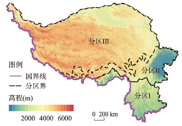
图1
研究区高程及其基于K-means聚类算法的综合分区
Fig. 1
DEM of the study region and the regionalization by K-means cluster method
2 研究区介绍
青藏高原位于26°00′N~39°47′N、73°19′E~104°47′E,是世界最高的高原,称为“世界屋脊”。受地壳运动影响,青藏高原地区山脉发育活跃,域内主要包括昆仑山脉、祁连山脉、唐古拉山脉、巴颜喀拉山脉与冈底斯山脉等[16⇓-18]。此外,青藏高原也是长江,黄河及澜沧江的发源地,河流沿山川河谷广为分布[18]。气候要素方面,青藏高原降水受印度洋西南季风及其暖湿气流的作用,在空间上自东南海拔较低区域向西北高海拔地区逐渐降低,其中东南部的年均降水为2000 mm,而西北部高原地区年均降水仅为50 mm左右;青藏高原气温主要受海拔影响,随着海拔的升高,气温逐渐降低,且昼夜温差较大,有利于促进岩石风化作用[19-20]。植被由于其自身生长对于气候要素的变化极为敏感,其在空间上也呈现自青藏高原东南部的林地向西北部草甸过渡的时空分布特征[16-17]。
横断山区位于24°40′N~34°00′N、96°20′E~104°30′E,西临青藏高原,东连四川盆地,是中国第一阶梯向第二阶梯的地势过渡区[21⇓-23]。地形地貌方面,受亚欧板块,印度板块与太平洋板块的挤压作用,横断山区地质活动活跃,形成了南北分布的金沙江断裂带与鲜水河断裂带等规模不一的断裂带[1]。在板块挤压与河流下切的综合作用下,横断山区逐渐形成了山高谷深的地貌特征,其中81.5%的区域相对高差
青藏高原及横断山区复杂的地貌特征及气候条件为滑坡、泥石流、崩塌等地质灾害形成了良好的孕灾环境[28-29]。从空间分布角度分析,研究区综合分区Ⅰ主要包括横断山区南部地区及青藏高原南部区域;研究区综合分区Ⅱ主要包括横断山区北部地区及青藏高原南部区域;研究区综合分区Ⅲ主要包括青藏高原大部分地区(图1)。综合分区的区域性特征也间接表明了青藏高原及横断山区地质灾害孕灾环境在空间上的差异性,而孕灾环境的空间分异也决定了不同分区内地质灾害致灾机理与成灾边界的分异性,进一步证明了地质灾害易发区随机森林预测模型分区训练的必要性。因此,本文进一步基于各分区地质灾害点对应的孕灾环境要素构建、训练与验证适合于各分区的地质灾害易发区随机森林预测模型。
3 数据及方法
3.1 数据
采用ERA5月尺度再分析降水与气温数据(1981—2020年)量化了研究区多年最大降水及最大温差的空间分布,空间分辨率为0.1
由于本文在建模过程中纳入了坡度因素,而其与坡高与相对高差均可基于DEM计算而来,其间具有较强相关性,故不宜同时纳入到随机森林模型中进行模型构建与预测,会人为增加DEM因素在随机森林预测结果中的影响权重。因此,本文采用基于DEM计算而来的坡度因素反映研究区地形特征对于地质灾害易发性的影响。此外,由于受数据限制,本文无法将青藏高原及横断山区的斜坡结构纳入建模过程。值得注意的是,斜坡的结构对于判断地区地质灾害易发性具有显著的指示作用,被广泛应用于小尺度的地质灾害易发性及危险性评估。在以后的研究中,我们将持续跟进纳入斜坡结构因素的地质灾害易发性评估模型的构建。本文仅通过坡度、岩性与距断层距离3个要素来综合评估地质地貌对于地质灾害的影响。
3.2 基于K-means聚类算法的综合分区划分
3.3 灾害点及非灾害点样本集
本文所采用的青藏高原及横断山区的地质灾害点数据获取自地质云水工环地质信息服务平台(
图2
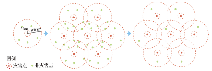
图2
地质非灾害点样本生成过程
Fig. 2
The generation process of non-geological disastrous points for each sub-region.
图3
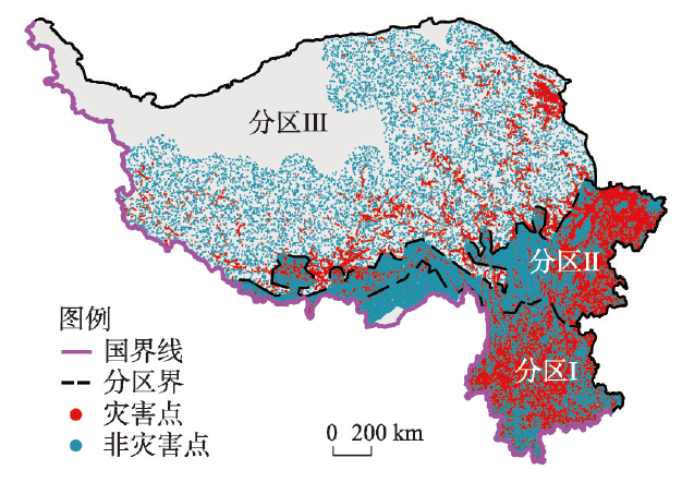
图3
青藏高原及横断山区地质灾害点与非灾害点
Fig. 3
Disastrous and non-disastrous points applied for training and validating of the random forest-based model over the study region
3.4 随机森林分类模型
本文基于R语言中的“Random Forest”包构建了研究区点尺度孕灾环境与灾害事件(0/1事件)的随机森林分类预测模型[32](式(1)),在由总数据集中随机选择的70%的样本组成的训练集进行训练,在剩余的30%的样本进行验证,以实现通过孕灾环境的组合条件来判断样本点是否为地质灾害点的预测目标。
式中:f(0,1)i, j为随机森林预测模型判断分区j中点(像元)i是地质灾害点/非地质灾害点的预测结果;Prmax、Tdmax、S、L、V、disroad、disriver与disfault分别为分区j中点(像元)i处的最大降水、最大温差、坡度、岩性、植被覆盖状况、像元距道路距离、像元距河流距离及像元距断层距离;ωPr、ωTd、ωS、ωL、ωV、ωdisroad、ωdisriver、ωdisfault分别表示分区j中点(像元)i处的最大降水、最大温差、坡度、岩性、植被覆盖状况、像元距道路距离、像元距河流距离及像元距断层距离的模型权重;
4 结果分析
4.1 气象要素空间特征
本文基于ERA5再分析降水数据集量化了青藏高原及横断山区1981—2020年月最大降水与最大温差的空间格局。研究区月最大降水在空间上整体呈南高北低的空间分布(图4a),其中65~95 mm的最大降水区间主要分布在青藏高原南麓地区,主要归因于5—10月东亚及南亚季风对青藏高原南麓地区的水汽输送作用,以及及青藏高原对来自印度洋水汽的拦阻作用[26-27]。在各分区尺度,综合分区Ⅰ内的月最大降水区域均值为20.68 mm;综合分区Ⅱ内的月最大降水区域均值为15.08 mm;综合分区Ⅲ内的最大降水区域均值为6.43 mm(图4b)。这与研究区最大降水整体“南高北低”的空间分布特征是一致的。此外,最大降水是地质灾害中滑坡与泥石流的主要驱动力之一。因此,从孕灾环境的角度,最大降水在综合分区Ⅰ内引发“暴雨—滑坡”与“暴雨—泥石流”两种灾害链的驱动作用高于综合分区Ⅱ~Ⅲ。
图4

图4
1981—2020年研究区气象条件空间特征
Fig. 4
Spatial pattern of the meteorological variables across the study region
4.2 下垫面空间特征
坡度高值区(> 20°)分布在横断山脉北部地区,横断山脉与喜马拉雅山脉交汇地区及东北部的昆仑山脉地区,而其低值区(0~20°)主要分布在青藏高原面,四川盆地及横断山区东南部地区(图5c)。在各分区尺度,分区Ⅰ~Ⅲ内的坡度区域均值分别为21.5°、21.8°及14.3°(图5d)。从滑坡与崩塌两种地质灾害的成灾机理分析,坡度大小决定了松散堆积物及破碎岩石在滑坡体滑动面及崩塌体崩塌面上受到重力作用的大小,即反映了重力作用对于滑坡与崩塌两种地质灾害的启动作用。在适宜坡度范围内,坡度越大,重力对于滑坡与崩塌两种地质灾害的启动作用越强[35]。结合研究区坡度的空间分布模式,重力作用在横断山脉北部地区,横断山脉与喜马拉雅山脉交汇地区及东北部的昆仑山脉地区对于松散堆积物及破碎岩石下落的启动作用显著强于青藏高原面,四川盆地及横断山区东南部地区的松散堆积物与破碎岩石下落的启动作用。
图5
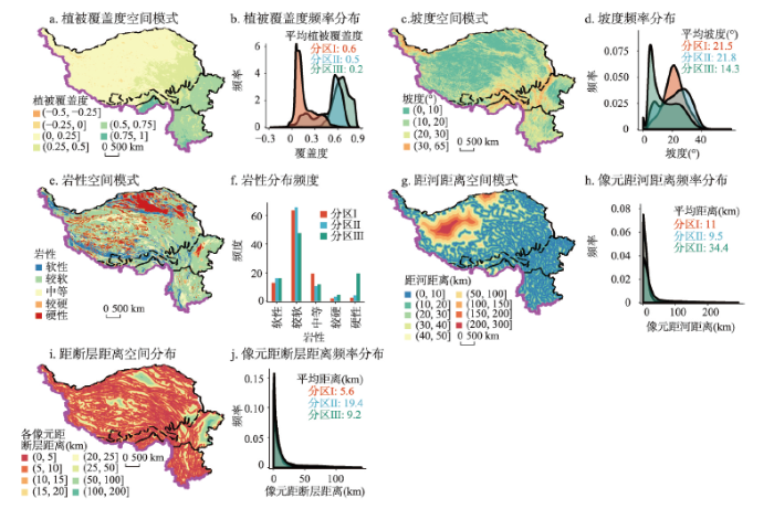
青藏高原及横断山区断层分布密度高,地壳活动活跃,极易发育崩塌、滑坡与泥石流等地质灾害[28-29]。受降水、气温、土壤、坡度、高程等影响,青藏高原及横断山区植被覆盖的空间格局呈南高北低(图5a)。在各分区尺度,综合分区Ⅰ~Ⅲ内的NDVI区域均值分别为0.6、0.5及0.2(图1、图5)。从滑坡成灾机理分析,植被对于滑坡的形成既具有抗阻作用,也具有加剧作用,需要结合坡度等坡面因素来综合分析[36]。在坡度小,坡面稳定,原生植被盖度大的区域,植被通过其根系的锚固作用及其叶面对于降水下落速度的降低作用可以增强保护作用;而在坡度大,坡面不稳定,植被的生长过程增加了坡面的生物量,同时通过根系延伸破坏了坡面的力学稳定性,进而加剧了滑坡的形成。结合上文的坡度分析结果,综合分区Ⅰ~Ⅱ内的坡度区间为0~65°,且该分区植被盖度高。对于综合分区Ⅰ~Ⅱ内坡度处于0~15°的地区,坡度较小且植被覆盖度高,植被对于坡面具有保护作用;而对于综合分区Ⅰ~Ⅱ内坡度>15°的地区,坡度较大且植被覆盖度高,植被生长对于该地区的地质灾害形成具有促进作用,会在坡面上形成具有标志性的醉林。而对于综合分区Ⅲ,该地区主要包括青藏高原的高原面,坡度较缓,植被类型以高原草甸为主,植被生长对于其大部分地区的坡面具有保护作用。而对于该地区一些峡谷地区(坡度>15°的地区),灌木林的生长对于该地区的地质灾害形成则具有加剧作用。
青藏高原及横断山区岩性以较硬性与硬性为主,仅有青藏高原北部地区与中部零散区域及横断山区北部区域岩性以软性为主(图5e)。在各分区尺度,综合分区Ⅰ内(横断山区南部区域)硬性岩、软硬性岩、中等硬性岩、较软性岩及软性岩分布面积占比分别为13%、63%、19%、2%及2%;综合分区Ⅱ内(横断山区东北部区域及青藏高原南部区域)硬性岩、软硬性岩、中等硬性岩、较软性岩及软性岩分布面积占比分别为16%、66%、11%、3%、4%;综合分区Ⅲ内(横断山区东北部区域及青藏高原南部区域)硬性岩、软硬性岩、中等硬性岩、较软性岩及软性岩分布面积占比分别为16%、48%、12%、5%及20%(图5f)。从滑坡及崩塌等地质灾害的致灾机理分析,岩性的软硬决定着坡面岩石抗剪与抗风化能力的大小,岩性越硬,其抗剪与抗风化能力越强,同等外部条件下更不容易形成滑坡与崩塌等地质灾害。对于分布在青藏高原北部地区与中部零散区域及横断山区北部区域的软性岩而言,软性岩(如泥岩等)较弱的抗风化与抗剪能力会使得该区域更易因岩石破碎或坡面失稳而发生不同规模的地质灾害。
研究区大部分区域距断层距离为0~25 km,仅有横断山区东北部边缘地区距离断层大于50 km,最远达到100~200 km(图5i)。在各分区尺度,综合分区Ⅰ~Ⅲ内的距断层距离区域均值分别为5.6 km、19.4 km及9.2 km(图5j)。从地质灾害成灾机理角度分析,活动断层诱发的地震活动,形成断层面,导致山体坡面失稳,进而引发“地震—滑坡”与“地震—崩塌”等地质灾害链[37-38]。而不同于活动断层,非活动断层不会诱发地震活动,但其断层面会促进滑坡等地质灾害过程中滑坡面的形成,进而促发滑坡等地质灾害。因此,本文选择研究区像元距离断层的空间距离来衡量像元受活动断层与非活动断层对于像元处地质灾害形成的影响程度,像元距离活动断层与非活动断层的距离越近,像元越容易受到活动断层与非活动断层的影响。
4.3 人类活动空间特征
研究区人类活动包括居民区建设、矿区建设、道路建设等,但由于研究区地质灾害多发在河谷地带,而该区人类活动主要为道路建设,因此,基于2020年研究区道路数据集对研究区1 km
图6
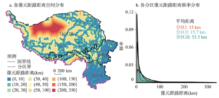
图6
研究区人类活动空间特征
Fig. 6
Spatial pattern of the human activities across the study region
4.4 地质灾害易发区空间特征分析
验证结果表明分区构建的随机森林模型在各分区内对于地质灾害点与非灾害点的预测判识精度均高于0.8(p < 0.05),分别为0.83、0.91与0.87,均可在点尺度准确预测各分区内的地质灾害点与非灾害点。此外,由于灾害点与非灾害点在综合分区Ⅰ(除西北部区域)与综合分区Ⅱ~Ⅲ内充分且均匀分布,经过灾害点和非灾害点数据集训练与验证的模型可被应用于各分区像元尺度地质灾害易发区的预测。根据本文模型的预测结果,研究区地质灾害易发区主要分布在横断山区南部与东北部以及青藏高原中南部地区(图7a)。具体而言,综合分区Ⅰ~Ⅲ内的地质灾害易发区面积分别为17.5万km2(占比44.5%)、17.4万km2(占比36.5%)及27.5万km2(占比12.8%)。
图7
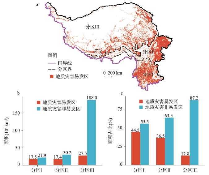
图7
研究区地质灾害间特征
Fig. 7
Spatial patterns of the geological disasters over the study region
然而,本文提出的模型仍有不足。由于在青藏高原西北部地区没有历史记录与统计的灾害点数据集,故本文构建的模型在该区域的预测结果存在不确定性。在以后研究中获取充分数据后,我们将进一步对该区域的地质灾害易发区情况进行研究与分析。
4.5 地质灾害易发区成灾归因分析
根据基于实际观测的地质灾害点数据对于青藏高原及横断山区的地质灾害规模的分级,本文对各分区的地质灾害点的规模进行分级统计,未统计无标记规模的地质灾害点数量为6756个。在整个青藏高原与横断山区,大型与特大型的地质灾害共计6640个,其中45%分布在综合分区Ⅰ(2989个),42%分布在综合分区Ⅱ(2774个),仅有13%分布在综合分区Ⅲ(877个)(图8)。大型及以上等级的地质灾害空间分布的差异主要归因于各分区不同的地质地貌特点。其中,青藏高原(综合分区Ⅲ)除南部喜马拉雅山脉地区落差较大以外,中北部地区地貌特征则以高原面为主,地势较为平缓。这种地质地貌特点也使得青藏高原大型及特大型地质灾害主要分布在其南部地区。不同于青藏高原地区,横断山区地区(综合分区Ⅰ~Ⅱ)的地质地貌构造中“沟壑纵横,地形落差大”的地质地貌特点更有利于形成大型及特大型规模的地质灾害。因此,共计超过87%的大型及特大型规模的地质灾害点主要分布在横断山脉地区。
图8
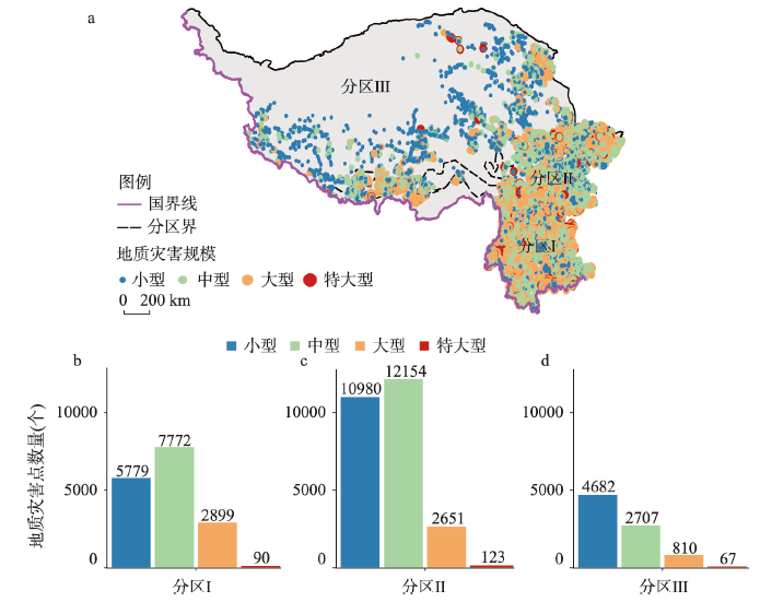
图8
各综合分区不同规模地质灾害分级统计
Fig. 8
Statistic of different scales of geological disasters within each sub-region
值得注意的是,青藏高原与横断山脉地区大型及特大型的地质灾害(包括滑坡、泥石流与崩塌等)主要是由于地质内、外动力作用下发生的。但是,在空间分布上,大型地质灾害的数量仅为少数,仍以中小型地质灾害为主。总体上,整个研究区中小型与中型规模的地质灾害点总计44074个,占所有规模地质灾害点(50714个)的87%。不同于大型及特大型的地质灾害,小型及中型的地质灾害的形成则是由地形地貌、气象及人类活动等综合因素共同引发的。具体而言,在综合分区Ⅰ(表1),导致小型及中型地质灾害的主要因素为距离道路距离(贡献率为20.2%),最大降水(贡献率为18.9%)与最大温差(贡献率为15.1%),表明综合分区Ⅰ内(横断山区中南部地区)小型及中型地质灾害的形成主要归因于道路建设导致的沿途坡面稳定性的变化,降水侵蚀驱动作用与岩石及松散堆积物风化;在综合分区Ⅱ(表1),导致小型及中型地质灾害的主要因素为植被覆盖状况(贡献率为23.6%),距离道路距离(贡献率为15.7%)与最大温差(贡献率为14.5%),表明综合分区Ⅱ内(横断山区北部地区及青藏高原东南麓地区)小型及中型地质灾害的形成主要归因于植被覆盖状况的变化对于坡面稳定性的影响,道路建设导致的沿途坡面稳定性的变化与岩石及松散堆积物的风化;在综合分区Ⅲ(表1),导致小型及中型地质灾害的主要因素为植被覆盖状况(贡献率为27.3%),距离河流距离(贡献率为17%)与距离道路距离(贡献率为16.8%),表明综合分区Ⅲ内(青藏高原大部分地区)小型及中型地质灾害的形成主要归因于植被覆盖状况的变化对于坡面稳定性的影响,河流对于周边坡面的侵蚀作用及道路建设导致的沿途坡面稳定性的变化。
表1 研究区地质灾害易发区成灾归因分析(%)
Tab. 1
| 成灾因素 | 综合分区Ⅰ | 综合分区Ⅱ | 综合分区Ⅲ |
|---|---|---|---|
| 最大降水 | 18.9 | 16 | 11.2 |
| 最大温差 | 15.1 | 14.5 | 11.8 |
| 植被覆盖状况 | 13.9 | 23.6 | 27.3 |
| 坡度 | 9.5 | 6.4 | 6.7 |
| 距河流距离 | 11.5 | 10.9 | 17 |
| 距道路距离 | 20.2 | 15.7 | 16.8 |
| 距断层距离 | 8.3 | 9.2 | 6.1 |
| 岩性 | 2.5 | 3.6 | 3 |
5 结论
为了精准识别青藏高原及横断山区不同地貌、气象条件与人类活动影响条件下地质灾害的易发区,本文在研究区各综合分区构建了基于随机森林算法的灾害点判识模型,并在点尺度完成精度验证后推演到整个研究区,对青藏高原及横断山区的滑坡、泥石流与崩塌等地质灾害的易发区进行了空间预测与成因分析,得出了以下结论。
(1)基于等量灾害点与非灾害点的样本集的随机森林灾害点判识模型在青藏高原及横断山区各综合分区的判识精度均高于0.8,分别为0.83、0.91与0.87,可准确预测研究区各分区的地质灾害点。
(2)青藏高原及横断山区地质灾害易发区主要分布在横断山区南部与东北部以及青藏高原中南部地区,综合分区Ⅰ~Ⅲ的地质灾害易发区面积分别为17.5万km2、17.4万km2与27.5万km2,分别占各分区面积的44.5%、36.5%与12.8%。
(3)受地质地貌空间分布差异,青藏高原及横断山区中87%的大型及特大型地质灾害点分布在地质地貌条件复杂,沟壑纵横,地形落差大的横断山区地区(综合分区Ⅰ~Ⅱ),仅有13%主要分布在青藏高原南部地质地貌条件复杂的喜玛拉雅山脉地区。此外,青藏高原及横断山区地区地质灾害规模以小型及中型为主,占比为87%。相比于主要在地质内、外动力作用下发生的大型及特大型地质灾害,小型及中型的地质灾害则是由地形地貌、气象及人类活动等综合因素共同引发的。
(4)由于青藏高原及横断山区地质地貌条件、气象条件与人类活动影响的空间差异性,研究区各分区地质灾害的成因具有空间分异性。在不考虑地质灾害规模分级的情况下,综合分区Ⅰ内(横断山区南部区域)小型及中型地质灾害的主要驱动力为道路建设导致的沿途坡面稳定性的变化(贡献率为20.2%);综合分区Ⅱ~Ⅲ内(横断山区东北部区域及青藏高原南部区域)小型及中型地质灾害的主要驱动力为植被覆盖状况的变化对于坡面稳定性的影响(贡献率分别为23.6%与27.3%),而综合分区Ⅱ~Ⅲ内第二大影响小型及中型地质灾害形成的因素分别为道路建设导致的沿途坡面稳定性的变化(贡献率为15.7%)与河流对于周边坡面的侵蚀作用(贡献率为17%)。
参考文献
A dynamic hazard assessment for mountain hazards in Hengduan mountain area
横断山区山地灾害的动态危险性评价
Dominant control of the South Asian monsoon by orographic insulation versus plateau heating
DOI:10.1038/nature08707 URL [本文引用: 1]
Debris flows resulting from Glacial-Lake outburst floods in Tibet, China
DOI:10.2747/0272-3646.31.6.508 URL [本文引用: 1]
Characteristics and mitigation of Yigong rapid huge landslide in Bomi, Tibet
西藏波密易贡高速巨型滑坡特征及减灾研究
Study on successive landslide damming events of Jinsha River in Baige village on October 11 and November 3, 2018
2018年10月和11月金沙江白格两次滑坡-堰塞堵江事件分析研究
Analysis on the formation mechanism and process of Baige landslides damming the upper reach of Jinsha River, China
堰塞金沙江上游的白格滑坡形成机制与过程分析
A preliminary analysis of the formation mechanism and development tendency of the huge Baige landslide in Jinsha River on October 11, 2018
金沙江“10.11”白格特大型滑坡形成机制及发展趋势初步分析
Types and characteristics of slow-moving slope geo-hazards recognized by TS-InSAR along Xianshuihe active fault in the eastern Tibet Plateau
DOI:10.1007/s11069-017-2943-y URL [本文引用: 1]
Early identification of serious geological hazards with integrated remote sensing technologies: Thoughts and recommendations
重大地质灾害隐患早期识别中综合遥感应用的思考与建议
Integrated space-air-ground early detection, monitoring and warning system for potential catastrophic geohazards
基于天-空-地一体化的重大地质灾害隐患早期识别与监测预警
Primary recognition of active landslides and development rule analysis for pan three-river-parallel
青藏高原泛三江并流区活动性滑坡InSAR初步识别与发育规律分析
Machine learning methods for landslide susceptibility studies: A comparative overview of algorithm performance
Mapping flood susceptibility in mountainous areas on a national scale in China
DOI:10.1016/j.scitotenv.2017.10.037 URL [本文引用: 1]
Debris flow susceptibility and its reliability based on random forest and GIS
随机森林与GIS的泥石流易发性及可靠性
Spatial prediction of landslide susceptibility using hybrid support vector regression (SVR) and the adaptive neuro-fuzzy inference system (ANFIS) with various metaheuristic algorithms
Terrestrial net primary production and its spatio-temporal patterns in Qinghai-Xizang Plateau, China during 1982-1999
1982-1999年青藏高原植被净第一性生产力及其时空变化
Spatial and temporal patterns of NPP and its response to climate change in the Qinghai-Tibet Plateau from 2000 to 2015
DOI:10.31497/zrzyxb.20201016 URL [本文引用: 2]
2000-2015年青藏高原植被NPP时空变化格局及其对气候变化的响应
Changes of climate and climate extremes in the Three-Rivers' headwaters region over the Tibetan Plateau during the past 60 years
青藏高原三江源地区近60年气候与极端气候变化特征分析
Study on spatial-temporal variation of net primary productivity for the Tibetan Plateau in recent 30 years
青藏高原近30年植被净初级生产力时空演变研究
Progress in research on soil erosion in Qinghai-Tibet Plateau
青藏高原土壤侵蚀研究进展
Spatial pattern and spatio-temporal change of territory space in Hengduan Mountains region in recent 25 years
DOI:10.11821/dlyj201803012
[本文引用: 1]

Hengduan Mountains have a high ecological value and offer resources for a variety of ecological services. However, the sustainable development and management of territory space has been challenged by increased human activities in recent years. In this paper, we used the land use data of Hengduan Mountains in1990, 2000, 2010 and 2015 to analyze the quantity and structural changes and spatial pattern changes on various types of territory space at different elevations, and reveal the characteristics and influencing factors of recent changes in various territory space patterns. The results show that, the territory space in the Hengduan Mountains has relatively high altitudes and significant vertical differences. Within the ecological-production-living space schema, the ecological space dominates the Hengduan Mountains, while the production and living space are mainly distributed in the southeastern Yunnan plateau. During the last 25 years, the ecological-production-living space changes in the Hengduan Mountains have been gradually accelerated and the regional differences have become more prominent. The agricultural production space has continuously decreased, while the industrial and mining production space has increased rapidly in the last 15 years. The living space has steadily increased, and the ecological space has increased with fluctuations. The territory space pattern in the study region is greatly restricted by the natural factors such as altitude and slope. The implementation of China Western Development strategy and Grain to Green Project have favorably promoted the changes of territory space pattern in this region. At present, the territory space in the Hengduan Mountains still faces the problems of destruction of ecological environment by high-altitude industrial and mining exploitation, soil erosion on sloping cultivated land and natural disaster. In the future, the national spatial optimization development in the Hengduan Mountains needs to strictly control the production space of industrial and mining industries, ensure the ecological space, carry out the protection of basic farmland, implement the reforestation of sloping cultivated land gradually, and strive to strengthen the construction of disaster prevention and mitigation system in living space.
近25年横断山区国土空间格局与时空变化研究
DOI:10.11821/dlyj201803012
[本文引用: 1]
横断山地提供多种生态系统服务,具有极高的生态价值,然而近年来面临人类活动强度增强所带来的国土空间可持续开发与管控挑战。利用横断山区1990年、2000年、2010年和2015年土地利用数据,分析不同海拔各种国土空间类型的数量、结构变化以及空间格局变化特征,揭示国土空间格局变化规律及影响因素。结果表明,横断山区国土空间海拔较高,垂直差异性明显,并且以生态空间为主体,生产、生活空间主要分布于东南部云南高原地区。25年间,三生空间变化加快且区域差异更突出,农业生产空间持续减少,工矿生产空间后十五年迅速增加,生活空间持续增加,生态空间波动增加。横断山区自然要素显著影响国土空间格局。西部大开发战略和退耕还林工程的实施明显带动横断山区国土空间格局变化。
Natural geographical differentiation and natural division of Hengduan Mountains area
横断山区自然地域分异和区划
Geomorphologic regionalization of the Hengduan Mountains region
横断山区地貌区划
Division of geologic structure in the Hengduan mountainous region
横断山区地质构造分区
Spatial pattern of debris-flow catchments and the rainfall amount of triggering debris flows in the Hengduan Mountains region
DOI:10.11821/dlxb201911008
[本文引用: 1]
Environmental factors determine the spatial and temporal distribution of debris flows. Understanding the relationship between debris flows and their effective factors is important for debris flows risk assessment at regional scale. In this paper, geographic detectors and gray correlation analysis are used to explore the relationship between 11 influencing factors, including precipitation, climate, landforms, geology, land cover type, soil thickness and topographic wetness, and the spatial distribution of debris flows-prone catchments, as well as the spatial and temporal correlation between precipitation and debris flows disasters in the Hengduan Mountains region. The results show that the topographic wetness index is the most dominant factor controlling the spatial distribution of the catchments, followed by topographic relief and soil thickness. Temporal correlation between debris flows disasters and precipitation characteristics has large regional heterogeneity. The rainfall characteristics of debris flows disaster events in different regions exhibit significant difference. The frequency of debris flows with rainfall, topographic wetness, topographic relief and soil thickness in the Hengduan Mountains region varies significantly in different zones, which indicates that not only the rainfall but also the other factors controlling the spatial pattern of debris flows should be reflected in debris flows early warning model in the region.
横断山区泥石流空间格局和激发雨量分异性研究
DOI:10.11821/dlxb201911008
[本文引用: 1]
地形、降雨等环境因子决定了泥石流的时空分布特征,理解泥石流与这些因子的关系有助于区域泥石流灾害风险评估与防灾减灾工作。以横断山区为研究区域,选取降水、气候、地貌、地质、土地覆盖、土壤厚度、高差势能以及湿度指数等因子,利用地理探测器和灰度关联分析等方法,探讨了环境因子与泥石流沟空间分布的关系以及降水特征与泥石流灾害的时间关联性。结果表明,湿度指数是决定泥石流沟空间格局的最主要因子,其次是高差势能和土壤厚度,多年平均分布的降水特征对泥石流沟分布的影响较小。泥石流灾害事件与降水特征的时间关联具有较大的区域异质性。泥石流发生地的激发雨量、湿度指数、高差及土壤厚度的统计分布在不同地貌、地质和气候单元中有明显差异。这表明泥石流预警不仅需要考虑雨量等激发因子,还必须考虑其他影响因素的空间差异性。
Variation character of annual, seasonal and monthly temperature and precipitation
横断山区气温和降水年季月变化特征
A study of ecosystem changes in longitudinal Range-gorge region and transboundary eco-security in southwest China
纵向岭谷区生态系统变化及西南跨境生态安全研究
Development characteristics of landslide hazards in Three-rivers Basin of southeast Tibetan Plateau
青藏高原东南三江流域滑坡灾害发育特征
Research on the mountain disaster and geological alignment fundamental of Sichuan-Tibet railway running through N-S mountain area
横断山区川藏线山地灾害和地质选线原则研究
Long-term groundwater storage variations estimated in the Songhua River Basin by using GRACE products, land surface models, and in-situ observations
DOI:10.1016/j.scitotenv.2018.08.352
[本文引用: 1]
Influences of climatic change and anthropogenic activities on the terrestrial water storage (TWS) change are significant in the mid- and high-latitude areas. Since 2002, the Gravity Recovery and Climate Experiment (GRACE) satellite mission has provided quantitative measurements of TWS changes with unprecedented accuracy at global, regional and basin scales. In this study, the noise level of various GRACE-derived TWS anomalies (TWSA) data were evaluated by using a generalized three-cornered hat (GTCH) method A time-dependent weights approach was adopted to obtain a combined TWSA series over the Songhua River Basin (SRB) from 2003 to 2013. Monthly TWSA data during the past decades (1982-2002) were reconstructed by using an artificial neural network (ANN) approach with the good performance evaluated by the correlation coefficient of 0.89 and the Nash-Sutcliff efficiency of 0.79 over the study region. In-situ groundwater level measurements were used for validation of the groundwater storage (GWS) changes (estimated by using GRACE-derived TWS changes in association with the other simulated components of water storage changes from land surface models (LSMs)). The primary driving factors of spatiotemporal variations of GWS, as well as their inter-/infra-annually varying characteristics, were explored:Me present study revealed that the variations of GWS featured a "downward fluctuations" (1982-1994), "stable upward" (1998-2008) and "decreasing dramatically" (2009-2013) period, respectively, over the SRB. In general, GWS had varied in a steady decline trend at a decreasing rate of 1.04 +/- 0.59 men year(-1) from 1982 to 1994. With the enhanced climatic and anthropogenic influences over the region since 2000, several severe fluctuations characterized the GWS variations with occurrences of spring droughts and flooding over the region, which suggested significant effects of global changes posed on GWS variations of the region. (C) 2018 Elsevier B.V.
Some methods for classification and analysis of multivariate observations//Cam L M L, Neyman J (ed.). Proceedings of the Fifth Berkeley Symposium on Mathematical Statistics and Probability
Mismatch in elevational shifts between satellite observed vegetation greenness and temperature isolines during 2000-2016 on the Tibetan Plateau
DOI:10.1111/gcb.14432 URL [本文引用: 1]
A calculation method for predicting landslides volumes of the debris flows in the Wenchuan earthquake area
汶川震区泥石流流域内滑坡物源量计算方法探讨
Identification and main controlling factor analysis of collapse and landslide based on fine DEM: Taking Jiacha-Langxian section of Yarlung Zangbo Suture zone as an example
基于精细DEM的崩塌滑坡灾害识别及主控因素分析: 以雅鲁藏布江缝合带加查-朗县段为例
Effect of ecological restoration plants root on slope reinforcement in shallow landslide prone region
浅层滑坡多发区典型植被恢复树种根系对土壤抗剪强度影响
Evolution characteristics of landslides triggered by 2008 MS8.0 Wenchuan earthquake in Yingxiu Area
2008年MS8.0 汶川地震诱发滑坡灾害在映秀地区的演化特征
