

1 引言
2020年5月习近平总书记考察山西时指出:“历史文化遗产是不可再生、不可替代的宝贵资源,要始终把保护放在第一位”①(①2020年5月11—12日习近平在山西考察时的讲话。)。作为中国文化遗产的重要组成部分,传统村落蕴含多重价值[1],其保护关乎文化多样性的存续和乡村重构与建设的成败。在乡村现代化和城镇化浪潮中,越来越多传统村落正面临“持续性破坏”甚至濒临消亡的严峻形势。如何保护并利用好传统村落成为不可忽视的重要实践问题和研究课题[2]。为全面掌握中国传统村落的生存状态和构建科学有效的保护体系,住房城乡建设部、文化部、国家文物局、财政部联合于2012年起开启五批传统村落评选运动,共计6819个村落列入国家传统村落名录。但名录评选仅是保护工作的开端,实现传统村落可持续发展与中华文明传承才是最终目标,因此传统村落保护仍任重道远。
传统村落研究已取得丰硕成果。金其铭在20世纪80年代就指出中国乡村聚落形成与地理环境存在密切关系[3]。自20世纪90年代开始被学者重视[4]至今,传统村落已吸引社会[5]、地理[6]、建筑[7]、经济[8]和旅游[9]等多学科研究者,探索其演化、布局、建筑、遗产、文化、环境、产业、开发与保护等主题,理论解释力不断加强。在研究方法方面,定性分析仍为主流,定量方法日益凸显。传统定量方法多应用于社区尺度研究,如聚焦传统村落价值[10]、乡村性[11]、活态性[12]、脆弱性[13]、环境[14]、乡村文化[15]、保护水平[16]、利用度[17]、旅游发展[18]的评价,或聚焦居民感知[19]、公民性[20]、旅游适应性[21]和乡愁[22]等利益相关者感知评价。近年来计算机技术的发展和空间分析技术的引入不仅开启可视化表达,更实现对地理因素的整合和从微观向宏观的突破。如将聚落配置图数学模型化[23],或基于地理信息系统技术(GIS)辅助空间重构或分析传统村落空间分异[24,25]、演化[26]、影响因素[27]等,或进一步使用形态指数[28]和分形维数[29]、空间句法[30]、引力模型[31]、景观基因组图谱[32]等研究聚落不同尺度的体系特征和划分标准。也有学者探索量化动态研究方法,如适用于乡村系统情景规划的系统动力学模型和适用于村落形态规划的元胞自动机模型等[33]。
目前传统村落保护研究仍有待突破:① 亟待个案向整体提升。研究对象和方法的局限导致当前研究多停留在个案层面,知识贡献零散,未能纳入或形成宏观理论框架。② 评价体系框架缺失。完整、稳定、明晰的保护评价体系缺失,导致难以进行保护水平的横向比较与纵向追踪,阻碍理论对话有效推进。③ 研究方法有待优化。微观定性研究难以实现从个案向整体跨越,GIS叠置技术解释存在较大主观性。一些研究引入局部空间关联指标(LISA)分析属性聚类关系,用于测度海拔、水系等地理数据可行,但测度大于村落地理范围的统计数据,则不满足局部空间自相关统计量构建的基本条件:一是局部空间自相关统计量之和等于相应全局空间自相关统计量;二是能够指示每个空间位置观察值是否与其邻近位置观察值具有相关性[34]。地理加权回归是处理空间关系的较好方法,但需解决传统村落相关变量的尺度和数据可得性问题。
“西南地区”沿袭自《西南夷列传》的狭义“西南”,后衍生出广义“西南地区”概念[35]。其边界因文化过渡性和渐变性而具有不确定性,因此本文采用行政区域划分,即包含云南、贵州、四川、重庆、西藏。国家传统村落名录中28%的村落都位于西南地区。童恩正认为“西南地区全境高度相差悬殊,动植物垂直分布差异很大,十分适宜原始人类繁衍生息,是链接亚洲大陆腹地与印巴次大陆及中南半岛的枢纽”[36]。地理区位的独特性、自然与人文生态的多样性、村落类型的完整性、人口的多民族性等决定西南地区传统村落蕴含着丰富的人地关系和文化景观,但也导致其保护与利用问题更突出。因此,西南地区是中国传统村落保护研究的最重要和最典型区域。
本文在理论层面构建传统村落保护研究模型,并以西南地区为例,使用地理分析技术探讨以往较为忽视的宏观视角下传统村落区域保护水平及影响因素。本文是对传统村落保护研究体系由个案向整体、由微观向宏观、由零散向系统、由单一向多元方法的推进,具有重要理论和实践价值。
2 传统村落保护研究模型构建
作为独特的人地景观,传统村落保护研究应载入地理要素,并区分不同时空尺度下的保护评价、影响因素和研究方法。传统村落既是村民生活社区,也是族群或地域共有遗产;其保护不仅是社区责任,也是各级行政单位乃至国家责任;其发展既受独特小环境影响,也卷入更广阔地域中。因此,本文基于宏观和微观基本尺度,构建包括评价体系和影响因素的传统村落保护研究模型。
2.1 传统村落评价体系模型
传统村落评价体系模型包含从宏观到微观的村落时空分布、整体保护水平和单一属性3个层次(图1)。宏观层次的时空分布是对一定区域内传统村落分布特征进行评价,凸显地理要素作用,但忽略了历史基数。微观层次的村落单一属性评价,可以精准聚焦某一属性,但难以兼顾传统村落多维属性的均衡。整体保护水平评价是秉持可持续发展观探讨传统村落整体保护情况,分为微观社区保护水平(Community Protection Level, CPL)和宏观区域保护水平(Region Protection Level, RPL)。社区保护水平CPL是在社区尺度评价特定村落整体保护水平,基于社区发展子系统和遗产保护子系统计算其可持续发展综合评价指数和协调发展度[37]。理论上通过计算区域内所有传统村落综合评价指数的算术平均值,即可推演该地区的区域保护水平,但耗时耗力。
图1
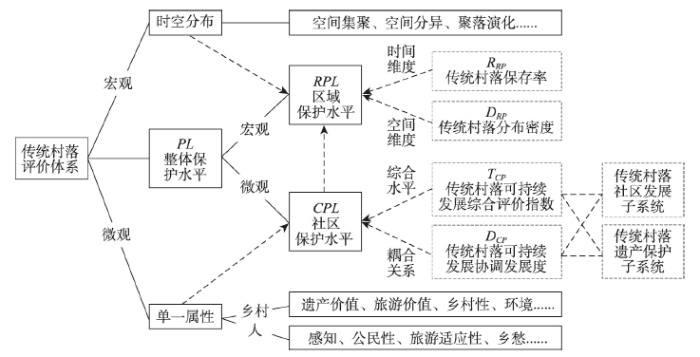
宏观层面的传统村落整体保护水平可直观体现为某地区在时间和空间两个维度是否保留更多的传统村落。同时,国家传统村落名录弥补了历史文化名城系列村落偏少的缺憾,完善了传统聚落体系[38],使得区域评估可行。因此,通过传统村落保存率RRP和传统村落分布密度DRP评价区域保护水平RPL,是更为宏观且简易的评价方法。
传统村落保存率RRP从时间维度评价区域传统村落保护水平,表征一个地区在现代化进程中保留下的传统村落比例,可以剔除村落形成时期的历史因素影响,其计算公式为:
式中:Ntv为区域所辖列入国家传统村落名录的村落数量;Nv为区域全部村级行政单位数量。综合考虑近年来“撤村并村”政策和数据可得性,Nv应选取较早时间截点。本文使用2005年数据。
传统村落分布密度DRP从空间维度评价区域传统村落保护水平,表征一个地区现存的传统村落空间分布密度。其计算公式为:
式中:Ntv为区域所辖列入国家传统村落名录的村落数量;A为该区域面积。
2.2 传统村落保护影响因素模型
传统村落保护的影响因素研究多为微观个案研究,在深入解读内在机理的同时,也囿于个案特殊性而降低普遍解释力,难以形成宏观保护理论。在“微观村落”和“整体社会”间找到结合点、建立具有广泛解释力的分析框架具有重要意义。
一个传统村落的发展历程可抽象简化为形成期、发展期、稳固期和衰落期(图2a)。在形成期即选址和聚落初步形成时期,村民生计依赖的自然基底成为主导因素;在发展期,随着人口增加、生产发展、社群形成和对外交往,自然因素影响力逐步下降,社会因素影响力逐步上升并超过自然因素成为主导;在稳固期,社会和自然因素长期保持稳定和良性平衡,村落规模稳定或缓慢增长,孕育和积淀丰富的文化遗产;在衰落期,社会和自然因素迅速变化、失衡且影响力增大,使得村落衰落乃至解体。在全球化和现代化裹挟下,社会因素往往成为衰落主导因素,并导致自然因素变迁。因此,在时间维度,自然因素是影响选址的主导因素,而社会因素成为影响其当代保护的主导因素。
图2
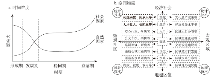
图2
传统村落保护影响因素模型
Fig. 2
Influencing factors model of traditional villages development
基于空间划分的传统村落保护影响因素模型包含空间尺度和要素类型两个坐标轴(图2b)。纵轴表征地理区位和经济社会两大影响因素类型,涵盖地形、水系、区位、交通、人口、经济和文化等主要因素。纵轴左侧和右侧分别表征这些因素在微观社区和宏观区域的表现形式。传统村落保护受到社区内外、微观和宏观力量共同作用,不同尺度研究重点和定量分析方法不同。当研究特定传统村落时,第三、四象限为主导影响因素,第一、二象限为次要影响因素,且宏观因素通过第三、四象限的微观因素发挥作用。当研究区域整体保护水平时,第一、二象限成为主导因素。
表1 西南地区传统村落区域保护水平的解释变量和分析方法
Tab. 1
| 类型 | 地理区位因素 | 经济社会因素 | ||
|---|---|---|---|---|
| 因变量 | 传统村落空间分异 | 区域传统村落保存率 | ||
| 区域传统村落分布密度 | ||||
| 解释变量 | 海拔 | 人口 | 人口密度 | 人口数/行政区域面积(人/km2) |
| 人口结构 | 城镇化率(%) | |||
| 水系 | 经济 | 经济发展 | 国内生产总值(万元) | |
| 产业结构 | 第二产业占国内生产总值比重(%) | |||
| 中心城市 | 交通 | 交通建设 | 公路里程(km) | |
| 交通流动 | 公路客运量(万人次) | |||
| 交通干道 | 文化 | 非遗规模 | 国家及省级非物质文化遗产项目数量(个) | |
| 分析方法 | 地理叠置分析 | GWR回归 | ||
3 研究方法
3.1 数据来源
传统村落数据来自住房城乡建设部、文化部、财政部联合公布的5批传统村落名录名单,西南地区共1910个传统村落入选。通过高德地图坐标拾取器获取地理坐标,将每一个传统村落抽象为空间上的点,运用ArcGIS 10.2将坐标数字化并导入矢量地图,构建传统村落空间属性数据库,并形成分布图(图3a)。行政区划矢量数据来自自然资源部标准地图服务网站;地形地貌数据来自中国科学院数据云中心90 m分辨率的数字高程数据DEM;水体、河网及公路网络空间数据来自ArcGIS Online所提供最新矢量数据。经济及社会发展数据来自《中国城市统计年鉴2019》、各省2019年统计年鉴和各城市2019年统计公报;2005年各城市所辖村委会(社区居委会)数量来自《中国民政统计年鉴附录2006》。考虑到西藏自治区无法准确获取全部统计数据、重庆市无法获得与其他地级市相同准则的非遗数据,为保证研究准确性,回归分析中剔除西藏所辖各市和重庆市。
图3
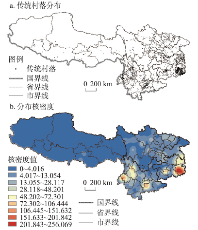
图3
西南地区传统村落分布图和分布核密度图
注:基于自然资源部标准地图服务网站下审图号为GS(2016)2923号的标准地图制作,底图边界无修改。
Fig. 3
Distribution and kernel density of traditional villages in Southwest China
3.2 研究方法
3.2.1 最临近点指数 最邻近距离表示点状事物在地理空间中相互邻近程度,其计算方法为测定每个点与其最邻近点之间的距离r1,其平均值
式中:m为点数;A为区域面积;D为点密度。最邻近点指数R为实际最邻近距离与理论最邻近距离的比值,其计算公式为:
当R = 1时,点要素为随机分布;当R > 1时,点要素为均匀分布;当R < 1时,点要素为集聚分布。Z得分和p值判断是否具有统计显著性。
3.2.2 核密度估计法 核密度估计法是一种非参数估计方法,即借助一个移动单元格对给定区域的点或线格局的密度进行估计。核密度估计方法不利用数据分布的先验知识、不附加任何假定,是从数据样本本身出发研究数据分布特征的方法[34]。核密度估计函数的计算公式为:
式中:K(∗)为核函数形式;h为带宽;x-xi表示估计点x到已知xi点的距离。
3.2.3 地理叠置分析 叠置分析是将同一地区两组或两组以上要素进行叠置,产生新特征的分析方法[41]。将传统村落地理位置信息与数字高程地图(DEM)、五级水系、主要交通线路(高速公路、国道和省道)、中心城市分布数据在ArcGIS 10.2中进行叠加,以揭示上述地理区位因素对于区域保护水平的影响。
式中:y为观测的因变量;xk为第k个自变量的值;n为自变量个数;α0为常数项估计值;αk为第k个自变量的系数估计值;ε为误差项。
继而将通过检验的自变量进行GWR分析,其模型[34]为:
式中:(ui, vi)为第i个样点的地理坐标;yi为第i个样点的观测值;xik为第k个自变量的值;n为自变量个数;β0(ui, vi)为第i个样点的常数项估计值;βk(ui, vi)为第i个样点的第k个自变量的系数估计值;εi为第i个样点的误差项。
使用高斯(Gauss)核函数法作为空间权函数,其函数形式[34]为:
式中:dij为空间单元i与j之间的距离;b为带宽,本文选取AICc最小化准则确定最优带宽。
4 西南地区传统村落区域保护水平的空间分异
4.1 西南地区传统村落分布的空间分异
2020年西南地区共有传统村落1910个,占全国总数的28.01%,是传统村落最集中的地区。贵州、云南、四川、重庆和西藏分别有传统村落724个、708个、333个、110个和35个,分别占西南地区的37.91%、37.07%、17.43%、5.80%和1.83%,分别占全国的10.62%、10.38%、4.88%、1.61%和0.51%,西藏远低于全国平均水平。黔东南州共有传统村落409个,占西南地区的21.41%;保山市、大理州、红河州、重庆市、铜仁市均超过100个;有20个地级市超过20个(表2)。西南地区传统村落分布极不均衡,云贵两省占比高达74.97%,6个地级市占比53.04%,20个地级市涵盖83.14%的传统村落。
表2 2020年西南地区传统村落数量、保存率、分布密度排名(前10名)
Tab. 2
| 排名 | 地级市/ 直辖市 | 数量 (个) | 百分比 (%) | 累计 百分比(%) | 地级市/ 直辖市 | 保存率 (%) | 地级市/ 直辖市 | 分布密度 (个/万km2) |
|---|---|---|---|---|---|---|---|---|
| 1 | 黔东南州 | 409 | 21.41 | 21.41 | 丽江市 | 15.04 | 黔东南州 | 134.82 |
| 2 | 保山市 | 130 | 6.81 | 28.22 | 迪庆州 | 14.29 | 安顺市 | 72.30 |
| 2 | 大理州 | 130 | 6.81 | 35.03 | 保山市 | 14.21 | 保山市 | 66.20 |
| 4 | 红河州 | 124 | 6.49 | 41.52 | 黔东南州 | 12.03 | 铜仁市 | 61.06 |
| 5 | 重庆市 | 110 | 5.76 | 47.28 | 大理州 | 11.57 | 大理州 | 44.07 |
| 5 | 铜仁市 | 110 | 5.76 | 53.04 | 红河州 | 9.56 | 红河州 | 37.69 |
| 7 | 甘孜州 | 71 | 3.72 | 56.75 | 西双版纳州 | 7.05 | 自贡市 | 29.67 |
| 8 | 黔南州 | 68 | 3.56 | 60.31 | 德宏州 | 6.53 | 丽江市 | 26.27 |
| 9 | 安顺市 | 67 | 3.51 | 63.82 | 日喀则市 | 5.59 | 黔南州 | 25.96 |
| 10 | 丽江市 | 54 | 2.83 | 66.65 | 玉溪市 | 5.29 | 玉溪市 | 24.09 |
注:各州名称使用了简称,如黔东南州指黔东南苗族侗族自治州、红河州指红河哈尼族彝族自治州。
西南地区传统村落整体最邻近指数为0.4236(表3),信度检验极度显著,呈显著集聚分布。重庆、云南、贵州、四川最邻近指数为0.5380~0.6697,信度检验极度显著,呈明显集聚分布,且集聚程度依次增加。西藏则倾向于均匀分布,信度检验不显著。
表3 西南地区传统村落最邻近指数及分布类型
Tab. 3
| rE | R | Z | p | 分布类型 | ||
|---|---|---|---|---|---|---|
| 西南地区 | 0.0882 | 0.2082 | 0.4236 | -48.1877 | 0.000*** | 集聚 |
| 贵州 | 0.0491 | 0.0833 | 0.5888 | -21.1687 | 0.000*** | 集聚 |
| 云南 | 0.0837 | 0.1388 | 0.6032 | -20.1986 | 0.000*** | 集聚 |
| 四川 | 0.1240 | 0.2304 | 0.5380 | -16.1281 | 0.000*** | 集聚 |
| 重庆 | 0.1220 | 0.1821 | 0.6697 | -6.6270 | 0.000*** | 集聚 |
| 西藏 | 0.6602 | 0.6513 | 1.0137 | 0.1543 | 0.877 | 均匀 |
选取带宽80 km为搜索半径,按照自然断点法(Jenks)分为9类密度区,获得边缘平滑且层次感较强的传统村落分布核密度图(图3b)。西南地区形成贵州东部、中部和云南西南、东南、北部5个传统村落热点集聚区。其中密度最高的贵州东部集聚区邻近贵州省界,次高的云南西南集聚区邻近中缅边境,热点集聚区和其他密度较高地区均邻近各市交界处,说明在行政区划边界地区传统村落分布较集中,而在腹地分布相对较少。
4.2 西南地区传统村落区域保护水平的空间分异
图4
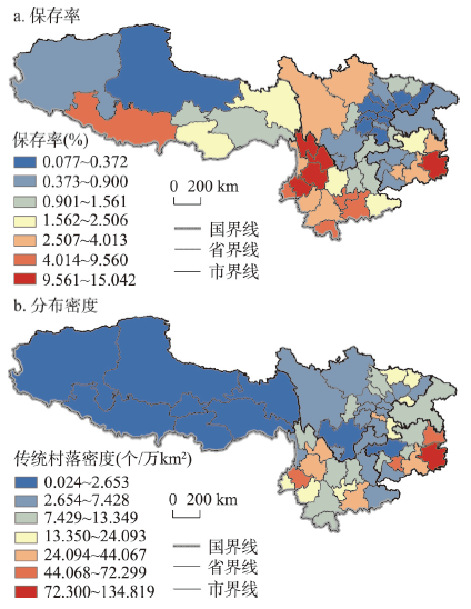
图4
西南地区区域传统村落保存率和分布密度的空间分布
注:基于自然资源部标准地图服务网站审图号为GS(2016)2923号的标准地图制作,底图边界无修改。
Fig. 4
Spatial distribution of retention rates and distribution densities of traditional villages in Southwest China
5 西南地区传统村落区域保护水平的影响因素
5.1 地理区位因素
5.1.1 海拔 西南地区传统村落在胡焕庸线两侧形成显著分布差异,左侧青藏高原片区分布密度最低,右侧形成云贵高原、四川盆地和云贵高原—湘桂丘陵盆地过渡地带3个高密度区(图5a)。从整体看,西南地区传统村落于500~1000 m分布最多,在其他海拔分布较均衡。位于海拔2000 m以上、1500~2000 m、1000~1500 m、500~1000 m和200~500 m的村落分别为327个(17.12%)、340个(17.80%)、347个(18.17%)、671个(35.13%)和225个(11.78%)。从局部微环境看,传统村落更多分布于高海拔地区的相对低海拔山谷和低海拔地区的相对高海拔山地中,在云南西南、四川东北部和青藏高原较显著。西南地区多变的地貌结构造就众多类型迥异的地理单元、多样化的气候特征和丰富的生物资源,为传统村落发育和保护提供了基础,形成自然景观和民族文化差异显著的西南村落景观。
图5

图5
西南地区传统村落海拔和水系分布
注:基于自然资源部标准地图服务网站审图号为GS(2016)2923号的标准地图制作,底图边界无修改。
Fig. 5
Elevation and river system distribution of traditional villages in Southwest China
5.1.2 水系 西南地区是中国水系最发达的地区之一,含长江、黄河、珠江、桂南沿海诸河、红河、澜沧江、怒江和伊洛瓦底江八大水系[45],占全国水资源总量的38.66%[46]。在五级河流缓冲区内传统村落分布数量最多(2 km缓冲区内347个,5 km缓冲区内649个),特别是下游水系发达地区传统村落分布多、密度大(图5b)。在四级及以上河流缓冲区分布减少(四级河流2 km缓冲区内99个,5 km缓冲区内151个;三级以上河流2 km缓冲区内133个,5 km缓冲区内274个),上游水流湍急、冲刷力强、暴雨洪水等自然灾害频发,不适合居住和村落长期保存。在村落选址和营建中,水系是最重要的生产生活和交通基础。村落一般选址于水系缓冲区内,而小型河流水系有利于聚落形成和延续。
5.1.3 中心城市 利用ArcGIS测算西南地区传统村落距省界平均为77.80 km,约为距省会城市距离(249.66 km)的1/4(表4),分别选择带宽60 km、30 km、5 km生成省会城市、地级市和传统村落分布核密度图(图6a)。距离中心城市30 km以内、30~60 km、60~90 km、90~120 km 和超过120 km的传统村落分别有318个(16.65%)、547个(28.64%)、473个(24.76%)、330个(17.28%)和242个(12.67%)。传统村落主要分布于中心城市核心辐射区的外围地区,呈现空间边缘化特征。现代化城市的规模膨胀和空间蔓延[39],加速了其辐射区内传统村落的消亡和对外围传统村落的侵蚀。因此城市核心区内与空间边缘化的传统村落应成为两种不同的研究类型。
表4 西南地区传统村落到省会城市和省界的平均距离
Tab. 4
| 区域 | 西南地区 | 重庆 | 四川 | 贵州 | 云南 | 西藏 |
|---|---|---|---|---|---|---|
| 距省会城市平均距离(km) | 249.66 | 196.20 | 262.58 | 188.03 | 286.51 | 314.98 |
| 距省界平均距离(km) | 77.80 | 15.70 | 72.93 | 52.22 | 76.69 | 93.64 |
图6
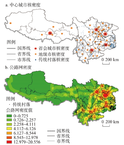
图6
西南地区中心城市核密度与公路网密度
注:基于自然资源部标准地图服务网站审图号为GS(2016)2923号的标准地图制作,底图边界无修改。
Fig. 6
Kernel density of central cities and density of highway network in Southwest China
5.1.4 交通干道 西南地区地形复杂、多山地峡谷,公路为主要交通方式。将高速公路、国道和省道形成公路网密度图,并与传统村落叠加(图6b)。按照自然断点法将公路网密度分为由高到低7个区间,其所覆盖的传统村落数量依次为5个(0.26%)、66个(3.46%)、215个(11.26%)、510个(26.70%)、450个(23.56%)、383个(20.05%)和281个(14.71%)。传统村落在公路网密度高值区分布稀疏,中值区分布最密集,低值区分布次密集。位于交通干道附近的传统村落更易卷入全球化和现代化浪潮,远离则可能面临空心化问题。处于适度距离区域既可保障生产生活需求和与现代社会的适度联系,又可延缓村落现代化进程和外部冲击。
5.2 经济社会因素
表5 OLS模型回归分析结果
Tab. 5
| 自变量 | 因变量 | 区域传统村落保存率 | 区域传统村落分布密度 | VIF | ||||||
|---|---|---|---|---|---|---|---|---|---|---|
| 初步回归 | 最终回归 | 初步回归 | 最终回归 | |||||||
| p | 标准化系数 | t | p | p | 标准化系数 | t | p | |||
| 人口 | 人口密度 | 0.020** | -0.444 | -3.542 | 0.001*** | 0.038** | 0.295 | 2.114 | 0.041** | 1.844 |
| 人口结构 | 0.144 | 0.261 | 2.440 | |||||||
| 经济 | 经济发展 | 0.287 | 0.014** | -0.370 | -2.727 | 0.009*** | 2.793 | |||
| 产业结构 | 0.478 | 0.251 | 1.510 | |||||||
| 交通 | 交通建设 | 0.014** | -0.322 | -2.246 | 0.030** | 0.670 | 1.809 | |||
| 交通流动 | 0.620 | 0.050** | -0.217 | -1.822 | 0.076* | 1.410 | ||||
| 文化 | 非遗规模 | 0.019** | 0.396 | 2.700 | 0.010*** | 0.000*** | 0.848 | 6.631 | 0.000*** | 2.053 |
| 模型指标 | R2:0.375 F:8.412 p:0.000*** | R2:0.532 F:11.637 p:0.000*** | ||||||||
注:*表示p<0.10,**表示p<0.05,***表示p<0.01。
将数据标准化后进行GWR回归,GWR模型R2(0.501和0.613)均高于对应OLS模型(0.375和0.532),阿凯克信息准则AICc值(116.24和105.35)均低于对应OLS模型(119.39和108.79)(表6)。当AICc值相差大于3,则具有较低AICc值模型更优[34],可见GWR模型均为更优模型。保存率模型局域R2为0.264~0.545,从东北向西南递减。分布密度模型局域R2为0.015~0.733,从东向西递减(图7)。95.65%的城市局部回归模型通过残差检验。保存率GWR模型中,回归系数由高到低依次为非遗规模、人口密度和交通建设,与OLS模型不一致。分布密度GWR模型中,回归系数由高到低依次为非遗规模、经济发展、人口密度与交通流动,与OLS模型一致。
表6 GWR模型回归分析结果
Tab. 6
| 自变量 | 因变量 | 区域传统村落保存率 | 区域传统村落分布密度 | ||||||||||
|---|---|---|---|---|---|---|---|---|---|---|---|---|---|
| Cave | Cmin | C25 | Cmed | C75 | Cmax | Cave | Cmin | C25 | Cmed | C75 | Cmax | ||
| 人口 | 人口密度 | -0.379 | -0.214 | -0.255 | -0.308 | -0.535 | -0.636 | 0.278 | 0.011 | 0.234 | 0.326 | 0.339 | 0.379 |
| 经济 | 经济发展 | -0.330 | -0.054 | -0.301 | -0.367 | -0.398 | -0.438 | ||||||
| 交通 | 交通建设 | -0.288 | -0.167 | -0.218 | -0.269 | -0.364 | -0.448 | ||||||
| 交通流动 | -0.169 | 0.004 | -0.134 | -0.187 | -0.230 | -0.270 | |||||||
| 文化 | 非遗规模 | 0.416 | 0.343 | 0.388 | 0.407 | 0.414 | 0.593 | 0.688 | 0.007 | 0.569 | 0.791 | 0.886 | 0.944 |
| 模型指标 | 带宽:46 R2:0.501 调整后R2:0.406 | 带宽:45 R2:0.613 调整后R2:0.529 | |||||||||||
注:Cave、Cmin、C25、Cmed、C75、Cmax分别表示回归系数的平均值、最小值、下四分位值、中位值、上四分位值和最大值。
图7

图7
西南地区传统村落保存率和分布密度的R2和标准化残差值的空间分布
注:基于自然资源部标准地图服务网站GS(2016)2923号标准地图制作,底图边界无修改。
Fig. 7
Spatial distribution of R2 and standardized residuals of retention rates and distribution densities of traditional villages
5.2.1 人口因素 人口因素包含人口密度和城镇化率两项指标。人口密度对西南地区传统村落区域保护水平具有显著影响。时间维度中,人口密度与保存率负相关。回归系数呈现从西南向东北递减的圈层结构(图8a),高值区集中于云南西南部的少数民族集聚区,低值区集中于四川和贵州人口密度较高的城市群区域。人口高密度地区易发展经济产业,继而对周边资源产生虹吸作用而发展为更大规模的城镇,进一步推动城市建设加速、规模扩张和人口集聚,传统村落被挤压而快速消失;人口低密度地区产业基础薄弱、城市化滞后,有利于传统村落保留。空间维度中,人口密度与传统村落分布密度呈现正相关,回归系数从东向西递减(图8b)。传统村落是保存至今的古代人口集中分布区,因此人口高密度地区的历史基数较大;另一方面,人口空心化会进一步加剧人口低密度地区传统村落的衰败。
图8
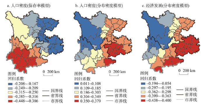
图8
西南地区人口因素和经济因素回归系数的空间分布
注:基于自然资源部标准地图服务网站GS(2016)2923号标准地图制作,底图边界无修改。
Fig. 8
Spatial distribution of regression coefficients of population and economic factors
城镇化率对于西南传统村落区域保护水平没有显著影响。一方面,城镇化率是城镇人口占全部人口比重,代表农业人口向非农人口的转型趋势。随着人口流动加快,传统户籍的非农人口类型已经不能完全表征地区城镇化发展水平。未来可通过新型城镇化相关指标再确认二者关系。另一方面,传统村落多分布于远离核心城市的乡村区域,城镇化率对区域传统村落保护水平影响可能较弱。
5.2.2 经济因素 宏观经济因素包括地区经济发展水平和产业结构。空间维度上,经济发展与传统村落分布密度呈负相关关系。回归系数从东南向西北递减(图8c),高值区为贵州和云南东南部,低值区为四川西部和云南西北部。经济发展对分布密度的影响力由东南向西北随海拔升高而递减,即在高海拔高原地区,经济发展对分布密度影响较小,而在低海拔的云贵高原—湘桂丘陵盆地过渡地区影响较显著。低海拔地区经济发展速度快、易于快速规模建设,而高海拔地区由于自然地理条件所限,缓慢的开发速度和严格的开发限制则有利于传统村落保存。经济发展与保存率无显著相关关系,产业结构与传统村落区域保护水平无显著相关关系。因此,传统村落保护不应排斥经济发展或特定类型产业,而应通过全面评估,避免过度快速扩张和建设性破坏,以更为平缓方式在保护中发展经济。
5.2.3 交通因素 交通因素包括硬性交通建设和软性交通流动,与传统村落区域保护水平负相关。交通建设与传统村落保存率负相关,相关系数由东向西、由腹地向边境增加(图9a)。一方面西南与腹地长期存在自然交通屏障、联系少;另一方面西南内部各少数民族村落受地理环境自然割裂而呈现小聚居特征,村落自给自足,彼此少有往来。系统动力学认为系统内部联系越弱,其修复力越差。一旦受到外来因素强力作用,如交通建设打破地理阻隔,西南传统村落更易受到剧烈冲击。因此交通基础越薄弱的地区,交通建设对于传统村落保存率影响越大。交通流动与传统村落分布密度呈现负相关,相关系数由东南向西北递减(图9b)。交通流动表征空间中人的流动性,人口高流动加剧流出地传统村落空心化和衰亡,加剧流入地因现代多元生活方式渗入而导致的异化和传统流失。
图9
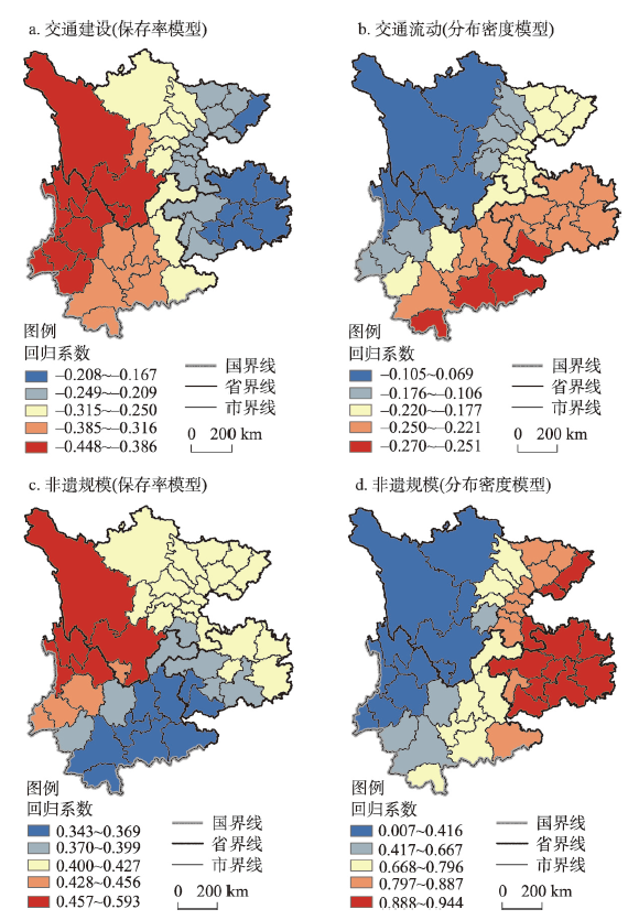
图9
西南地区交通和文化因素回归系数的空间分布
注:基于自然资源部标准地图服务网站GS(2016)2923号标准地图制作,底图边界无修改。
Fig. 9
Spatial distribution of regression coefficients of traffic and cultural factors
5.2.4 文化因素 文化是传统村落保护中最为显著的影响因素。非遗规模对传统村落保存率和分布密度都有显著正向影响。保存率模型中(图9c),回归系数高值区位于区域西北部,而低值区位于东南部。分布密度模型中(图9d),回归系数由东向西递减,区域间差异极大。其原因可能为:① 传统村落是文化遗产体系的重要组成。非遗根植于特定传统聚落环境,其规模在一定程度上代表地区传统文化基底,而传统村落名录评选也非常重视对非遗的考察。② 传统建筑与聚落是物质外在,而非遗是精神内核。村落空间结构是居民生活与文化的具体外在表现[48]。西南少数民族特定世居地文化系统共享生存空间、民间信仰对象与仪式,具有自我封闭的交流体系、知识系统和资源分配方式。村落是民族文化的基本展现地带和产生及传承基础[49]。当内核的非物质文化被传承,外在的村落物质表现才得以存续。③ 非遗作为地区政府管理和申报项目,其规模反映地区政府对于文化保护的态度和力度。在重视传统村落物质空间保存的同时,更需重视传统文化在传统村落保护中的重要作用。
6 结论与展望
6.1 结论
本文在理论层面构建传统村落保护研究模型,并以西南地区为例,使用地理分析技术着重探讨宏观视角下传统村落区域保护水平及影响因素。结论如下:① 传统村落保护的研究模型涵盖评价体系和影响因素两个子模型。传统村落评价体系模型包含从宏观到微观的村落时空分布、整体保护水平和单一属性三个层次,其中整体保护水平分为宏观区域和微观社区两个亚层,保存率和分布密度是评价区域保护水平的简易方法;传统村落保护影响因素模型则包含基于时间和空间划分的两类基本分析模型。② 西南地区传统村落区域保护水平呈现显著集聚分布。贵州东部、中部和云南西南、东南、北部形成热点集聚区,在行政区划边界地区分布较集中、腹地分布较少。云南西北部集聚区内的丽江市、迪庆州、保山市、黔东南州和大理州保存率最高,即时间维度的区域保护水平最优;黔东南州、安顺市、保山市和铜仁市分布密度最高,即空间维度的区域保护水平最优。③ 影响西南地区传统村落宏观保护水平的地理区位因素为海拔、水系、中心城市和交通干道,经济社会因素为人口、经济、交通和文化因素。保存率模型中,非遗规模为正相关,人口密度、交通建设为负相关。分布密度模型中,非遗规模、人口密度为正相关,经济发展、交通流动为负相关。各因素相关系数存在空间分异,其中非遗规模为最重要的影响因素。
6.2 讨论
本文构建的传统村落保护研究模型,突破定性研究局限,从横向、纵向与尺度三方面以定量分析拓展传统村落保护研究。不仅厘清保护评价和影响因素分析理论框架,也能有效指导实践。但本文仍存在诸多不足:① 影响因素的精准识别。本文中传统村落保护影响因素模型重在构建坐标维度的概念化模型,各象限具体因素有待完善。未来可通过对不同区域、尺度和类型传统村落保护水平的持续研究,不断识别各象限中的潜在影响因素库,并建立分地区、分类型的主要影响因素模型,以精准指导传统村落保护工作。② 影响因素的全面分析。本文所涉及村落数量庞大,且重点关注宏观保护水平评价和影响因素,未能分析微观因素。未来可进一步通过社区尺度的统计和地理数据(如村落海拔、500 m内水系等级、距离中心城市的时间距离等)更为精准分析微观影响因素。③ 叠加效应的谨慎识别。一方面是保护体系的叠加效应。部分城镇中心传统村落已成为城镇社区,并作为历史文化名镇名城的一部分得以保护,享有更高热度、更多资金和更优发展条件。这部分村落可能会放大或弱化某些因素影响力,需要谨慎考虑叠加效应。另一方面是影响因素的叠加效应。本文仅使用单一象限因素回归,但四个象限因素间具有潜在耦合关系,需要通过多重共线性进行剔除或通过已有研究识别不同象限因素间的叠加效应。④ 研究对象的动态追踪。国家传统村落名录是目前涵盖最为广泛的传统村落体系,但受到地方政府积极性、倾向性等非保护相关因素影响,同时一些列入名录的村落也可能因保护不善而衰败或异化。因此,应逐步落实传统村落保护评价和退出增补机制,并纳入具有一定价值而未列入名录的村落作为研究对象。
致谢
感谢匿名审稿专家对本文模型和逻辑给予宝贵修改意见。
参考文献
Tourism and the reconfiguration of host group identities: A case study of ethnic tourism in rural Guangxi, China
Reconstruction of Guangzhou urban villages' traditional lineage culture in the context of rapid urbanization: From spatial form of ancestral hall to behavioral patterns of villagers
DOI:10.11821/dlxb201512010
[本文引用: 1]

China is a country with exuberant cultural traditions, yet little of which has been paid attention to in rapidly urbanizing context in contemporary China. Lineage refers to the organized group of descendants of a single ancestor by which the lineage membership is determined. Despite the disappearance of many villages in the city, the ancestral hall often survived as the symbolic tie between the single-lineage villagers. Previous studies on Chinese rural restructuring mainly focus on the societal and cultural consequences. What these two aspects in studies of rural areas tend to vanish, or only take it implicitly, is the spatial processes that is closely related to the societal and cultural restructuring. Therefore, this paper intends to apply the sociological architecture thinking in space syntax methodology to explore the social logic behind the transforming spatial character of the typical lineage architecture, the ancestral hall. Taking two typical ancestral halls located respectively in Liede and Zhucun urban villages in Guangzhou as the research objects, the paper has unfolded the relationship between the morphological characteristics and behavioral patterns of villagers. Through field survey and mapping and face-to-face interviews in the Leide and Zhucun villages, it is found that (1) The newly-built ancestral hall in Liede village shows great difference compared with the old one in Zhucun village owing to the need to adapt to the new social functions, which is embodied in such transformation in spatial form as the breaking of axial symmetry pattern and the declining position of the sacred space in the overall spatial organization; (2) The decline and restructuring of spatial functions and the correspondent spatial organization highly conforms to the waning of the lineage consciousness, in which many traditional sacrificing activities are replaced by entertainment activities, and recreation and feasting have become the primary activities for villagers in the ancestral halls. Compared with the old ancestral halls, the newly-built ones in the central locations, as in our Leide case, evolved into non-excluded space that is aimed at profit-generating in the course of urbanization; (3) As the representative for lineage culture, the evolving spatial morphology of the ancestral halls is the intuitive evidence of lineage culture's recession and reconstruction, reflecting the changing mode of villager behaviors; (4) In the time of the couple made??families after the 20th century, the lineage consciousness of villagers is in the gradual recession, especially when the overall cultural environment for traditions has changed drastically. To sum up, the study not only provides new perspective for studying the traditional architectural type and traditional villages, but also in practical terms gives valuable suggestions to the protection and regeneration of traditional architecture and milieu in the context of rapid urbanization.
城市化进程中广州城中村传统宗族文化的重构
Application and embodiment of local characteristics in the planning of tourism-oriented minority villages: The case of New Five-Trees village in Shilin
地方特色在旅游型民族村落规划中的应用和体现: 以石林五棵树新村为例
Tracing the density impulse in rural settlement systems: A quantitative analysis of the factors underlying rural population density across south-eastern Australia, 1981-2001
DOI:10.1007/s11111-006-0018-1 URL [本文引用: 1]
Community participation in tourism of Yubeng village: Means of participation and its significance for empowerment
雨崩村社区旅游: 社区参与方式及其增权意义
The discussion on evaluation and sustainable development models of traditional villages in western mountainous area of Beijing: A case study of traditional villages in Mentougou District of Beijing
北京市郊区传统村落价值评价及可持续利用模式探讨: 以北京市门头沟区传统村落的调查研究为例
The rurality appraisal and characteristics of different types of traditional villages in southern Jiangsu province: Based on surveys of 12 traditional villages in Suzhou
DOI:10.11821/dlyj020180535
[本文引用: 1]
As an essential attribute, rurality is the key to the survival of the villages. However, in the face of intense internal and external restructuring and differentiation, their rurality has been damaged, neglected or even buried in different degrees. This paper takes 12 traditional villages in Suzhou as the research objects, divides them into four categories according to the development paths, and constructs an index system of traditional villages to evaluate their own rurality. The result shows that the traditional villages in Suzhou have basically maintained a high level in rurality. But the compositions of rurality in different development paths have different characteristics. Rurality of skill-based villages is enhanced and balanced, which is driven by industry. Rurality of tourism development villages is polarized in one-sided activation. Self-exploration of comprehensive development villages maintains balanced rurality. And life service-oriented villages face the danger of rurality decay in urban-rural interaction. It is believed that the protection and development of traditional villages should be guided by the overall balanced improvement of rurality and choose an appropriate development path.
苏南不同类型传统村落乡村性评价及特征研究: 基于苏州12个传统村落的调查
Quantitative evaluation on the living state of traditional villages
DOI:10.13249/j.cnki.sgs.2020.06.006
[本文引用: 1]
Based on the theory of living state, this article aims to build an index system of the living state of traditional villages according to material heritage system, intangible heritage system and village residents system. The author obtained these data through literature review, field survey, questionnaire survey and local interview and other methods to quantitatively evaluate the living state of three different types of traditional villages in Xiangxi, Hunan Province. The results shows that: First, the problem of inactivation is relatively common among these villages, and Dongshan village has the worst living state, then Xiaoshi village, and Disun Miao village has the best living state. Second, from the perspective of the system level, material heritage is the most important factor affecting the living state of traditional villages; and from the perspective of the element level, demographic structure, historical buildings and pattern texture are the main factors that affect the living state of traditional villages. Third, from the perspective of system level, intangible heritage is the main factor that leads to the inactivation of traditional villages in Xiangxi area; from the perspective of elements level, population, traditional skills, and natural ecological environment are the main factors that lead to the inactivation of traditional villages. In general, the living state of tourism traditional villages is better than that of urbanized villages and traditional villages. However, there still has some differences between active contribution factors and inactivation factors in different types of villages.
传统村落活态性定量评价研究
The vulnerability factors of tourism traditional villages based on the interpretation structural model
基于解释结构模型的旅游型传统村落脆弱性影响因子研究
Suitability of human settlement environment in Buyi traditional villages in rocky desertification area of Guizhou, China
DOI:10.13287/j.1001-9332.201909.015
PMID:31529896
[本文引用: 1]
To investigate the traditional village living environment adaptability to desertification and topography, the suitability evaluation index system and weight of traditional Buyei traditional villages in the rocky desertification area human settlement were quantified using Delphi method and comprehensive weighting method. We calculated human settlements environment suitability value and threshold to comprehensively analyze the human settlements environment suitability. The results showed that 10% of the traditional Buyei traditional villages were located in the rocky desertification areas with high intensity and extremely high intensity and had the tradition of selecting the best environment. The index system of residential environment suitability was composed of five first-level indices (economy, historic culture, ecology, society, and building environment suitability) and 26 second-level indices. This index system was applicable to villages in karst regions. The comprehensive environmental suitability value (2.81-3.77), the economy value (0.77-1.17), the historic culture value (0.39-0.50), the ecology value (0.83-1.07), the social environment value (0.38-0.53) all decreased with the increasing intensity of rocky desertification, but the suitability value of building environment did not change, which ranged from 0.43 to 0.51. Rocky desertification had profound and synergistic impacts on economy, historic culture, ecology and social environment. The floor level of the human settlement suitability threshold was 2.93. If the threshold was lower than 2.93, it could be considered to move or take measures to improve its value. The suitability value (3.56) of traditional village living environment in mountain slope was higher than that in depression (3.42) and valley (3.16). The human settlement suitability of traditional villages in rocky desertification area was higher than that of ordinary villages, but was lower than that of normal landform, with the differences in economy and ecology being the main reasons. To improve the living environment of traditional villages in rocky desertification areas, we should strengthen the comprehensive control of rocky desertification and policy support, develop ecological economy and tourism, protect historic culture or choose ecological migration. This research could provide theoretical base for the planning and construction of village living environment protection in karst areas.
贵州石漠化区布依族传统村落人居环境适宜度
Cultural landscape protection compensation model of traditional villages and its application in Xiangxi
DOI:10.11821/dlxb202002012
[本文引用: 1]
Cultural landscape protection compensation is a new topic in modern human geography. In this paper, we firstly proposed the theoretical framework of cultural landscape protection compensation of traditional villages, and then set up the cultural landscape protection compensation model on the basis of proposed theoretical framework. Finally, we discriminated the driving factors and offered a proof to the model, which takes Xiangxi nationality autonomous prefecture in Hunan province as a case study. The results can be concluded as follows: (1) From the aspects of the traditional architectural style, the location and pattern of villages, dynamical inheritance of the intangible cultural heritage of villages, and the level of their social and economic development of villages, traditional villages in Xiangxi conforming to the implementation conditions of cultural landscape protection compensation. (2) From the aspects of landscape characteristics and values, external market recognition, self-loss, government management, etc., cultural landscape protection compensation of traditional villages in Xiangxi conforms to the proposed cultural landscape protection compensation model. (3) From the aspects of its driving factors, cultural landscape protection compensation features of the 82 traditional villages in Xiangxi are in accordance with the comprehensive driving mode of landscape characteristics, government management, external market and self-loss. (4) In the traditional villages of Xiangxi, the cultural landscape protection compensation can be divided into three types, namely, social and economic compensation, historical and cultural compensation, and natural environment compensation. The factors of each type, such as social economy, historical culture, natural environment, all influence the structure of the compensation model.
传统村落文化景观保护性补偿模型及湘西实证
The protection and its evaluation system of traditional village: A case study of traditional village in human province
传统村落保护度评价体系及其实证研究: 以湖南省首批中国传统村落为例
Study on utilization and its evaluation system of traditional villages: A case study of traditional villages in Hunan Province
传统村落利用度与评价指标体系研究: 以湖南省首批中国传统村落为例
Preliminary study on the assessment of tourism sustainability in ancient village: Taking world cultural heritage site Hongcun as an example
古村落旅游可持续性评估的初步研究: 以世界文化遗产地宏村为例
Spatial form and spatial cognition of traditional village in syntactical view: A case study of Xiaozhou Village, Guangzhou
句法视角下广州传统村落空间形态及认知研究
The impact of tourism development on the construction of citizenship for ancient village residents in rural China: The case study of Kaiping Diaolou Complex
DOI:10.11821/dlxb201808013
[本文引用: 1]
Since they were inscribed on the World Cultural Heritage List, ancient villages in rural China, which used to be relatively stable and closed communities, have embraced economic change that happened to the ways of life for the local residents as a result of the newly introduced economy and the flood of visitors. This paper takes Diaolou complex, a UNESCO Would Heritage site in China as a case study. It is found, after a seven-year study, that there is a significant correlation between the level of tourism development and the civic participation of local village residents. In this paper, a comparison is made between the conditions in three different ancient villages before and after they were recognized as World Cultural Heritage Sites. With a further analysis of the data provided by the current local authorities and travel agencies concerning the main sources of income and the new economic structure, we found that there are some discrepancies in tourism development among the three ancient villages. Furthermore, to provide a plausible explanation of the interaction between tourism development and the construction of local civil society and citizenship, this paper first articulates the concept of "citizenship" in the literature, and then examines the results from in-depth interviews and field researches.It is found that tourism development does bring about citizenship, viewed as a universal value, in the three adjacent ancient villages with similar governance patterns and similar traditions. In explaining the cultivation process and transformation mechanism of citizenship in traditional Chinese societies, this paper contributes to the studies in moral geography in China.
旅游发展对古村落村民公民性建构的影响: 以开平古碉楼群为例
The influencing factors and evaluation of farmer's adaptability towards rural tourism in traditional village: Based on the survey of 6 villages in Xiangxi Prefecture, Hunan
DOI:10.13249/j.cnki.sgs.2018.05.013
[本文引用: 1]
Based on the analytical framework of the adaptability of farmers toward rural tourism in traditional villages, this study constructs an adaptive evaluation index system, and takes 327 households of 6 traditional villages in Xiangxi Autonomous Prefecture, Hunan Province, as samples. Participatory rural appraisal (PRA) method is used to obtain data, and principal component analysis and cluster analysis are applied to analyzing the adaptability types, degree and influencing factors of farmer’s adaptability towards rural tourism in traditional villages. The results showed that: 1) The types of farmers' adaptability can be divided into 6 types: comprehensive adaptation, the cognition deficit, the ecological dominance, the policy deficit, the cultural dominant, and the lagging development, of which different types of characteristics are different. 2) The overall adaptability degree of comprehensive adaptation is relatively adaptive, and those of the other 5 farmers' adaptation are generally adaptive, but on the whole, the traditional village farmers in Xiangxi are adapting to the development of rural tourism. 3) Each adaptation type shows internal differences in the adaptability of the 6 factors that are policy, economy, culture, ecology, society and psychology, and other adaptation types in social, cultural and economic adaptability of the three factors are generally low except the farmers of comprehensive adaptation type. 4) The 13 impact factors of policy, social, ecological, economic and psychology factors, have obvious influences on the adaptability of farmers toward rural tourism, and the degree of influence are different. Finally, from the three aspects of farmers, communities and government, this article puts forward countermeasures and suggestions to improve the rural tourism adaptability of traditional village farmers.
传统村落农户乡村旅游适应性评价与影响因素研究: 基于湘西州6个村落的调查
The measurement of xiangchou and its resource value in traditional village tourism destinations: A case study in southern Jiangsu
DOI:10.31497/zrzyxb.20200707 URL [本文引用: 1]
传统村落旅游地乡愁的测度及其资源价值: 以苏南传统村落为例
Spatial differentiation and influencing factors of Chinese traditional villages
中国传统村落空间分异及影响因素
The characteristic of regional differentiation and impact mechanism of architecture style of traditional residence
DOI:10.31497/zrzyxb.20190906 URL [本文引用: 1]
中国传统民居建筑风貌地域分异特征与形成机理
Spatial morphology evolution of rural settlements induced by tourism: A comparative study of three villages in Yesanpo tourism area, China
DOI:10.11821/dlxb201404009
[本文引用: 1]
As the main reception base and important tourism attraction, tourism village is the core element of the tourism destination system, and has also become one of the most important forms of rural urbanization in China. Integrating the method of PRA (participatory rural assessment), GIS technology and HD remote sensing images, this study aims to analyze the spatial morphology evolution of rural settlements induced by tourism through a comparative study of three tourism villages in Yesanpo tourism destination. The results suggest that there exists a "core-periphery" pattern of the spatial evolution of rural settlements. The closer to the core scenic spot, the higher degree of land-use intensity the village shows, as well as the more mature tourism function and greater change in landscape pattern. In the research, Gougezhuang shows an increase of the floor area ratio from 0.17 to 0.44, with the most mature tourism function and destroyed landscape authenticity as well and it has the lowest authenticity index of 0.448. Liujiahe has gone through a largest increase of 96.54% in construction land area, with moderately mature tourism function and relatively stable authenticity of 0.566. Shangzhuang, in contrast, has the lowest construction land scale and intensity, with the poorest tourism function and most well-preserved landscape authenticity of 0.942. Overall, in term of the spatial morphology, the three villages are characterized by "modern town", "semi-urbanization" and "traditional village", respectively, in corresponding to three land development types: "intensive reconstruction type", "enclave extension type" and "in situ using type". Tourism village is the basic spatial unit of rural tourism. The spatial evolution patterns of these three villages present the spatial characteristics of the touristization of traditional villages in different stages, and also has great representative value for the management of rural settlements in tourism destinations of China.
旅游地乡村聚落演变与土地利用模式: 野三坡旅游区三个旅游村落案例研究
Spatial-temporal distribution and controlling factors of traditional villages in Huizhou region
DOI:10.13249/j.cnki.sgs.2018.10.013
[本文引用: 2]
Traditional ancient villages are the crystallization of Chinese rural civilization. Carrying out this study is particularly important and urgent for the sustainable development and cultural heritage protection of the traditional villages in the ancient Huizhou. The study chose 119 national traditional villages of the ancient Huizhou by Ministry of housing and urban-rural development of the People’s Republic of China official which has already been released as the research object, and took the methods of literature analysis and GIS spatial analysis as the research way. And the distribution characteristics of the traditional villages in the ancient Huizhou were revealed from the temporal and spatial scales, which were mainly used by the method of the GIS technology. And the factors which affected the temporal and spatial distribution of traditional villages in the ancient Huizhou were also discussed. It is found that the spatial distribution of traditional villages in the ancient Huizhou is clustered, obviously in basin, adjacent water as well as the marginal area, and it presents the distribution pattern that the number of the traditional villages on the around is more than the middle. Specifically, Yixian county has the largest number of traditional villages and the highest distribution density, which has formed the main gathering area of the ancient Huizhou traditional villages, followed by the ancient Huizhou district and Shexian county has formed a secondary core area of ancient Huizhou traditional villages. From the time point of view, the Song Dynasty (Northern Song and Southern Song) and the Tang Dynasty are the main period of the formation of the ancient Huizhou traditional villages, these two dynasties retained the most ancient villages, and the scope distribute are also the most widely. Finally, the article focused on the natural environment, population, transportation, urbanization and economic development level and other factors, which ancient Huizhou traditional villages have showed those distribution characteristics. As well as the research has found that the basin terrain with surrounded landscape, the moved central plains immigrants with all ethnic, the road traffic with less development, the relatively backward social economy and the protection policies with local governments are all the very important conditions for the retention and renewal of the traditional Huizhou villages, and to a certain degree, it has already become the key factor for the spatial and temporal distribution that affected the traditional villages in the ancient Huizhou. And in the long run, it is helpful to study the whole distribution of the traditional villages, which can protect the traditional villages in the ancient Huizhou, and it is also helpful to explore the social, economic and cultural development in the historical period of the ancient Huizhou.
徽州传统村落的时空分布及其影响因素
Research on spatial evolution of traditional settlements: The case study of Qianzhong Tunpu
DOI:10.1080/00420988720080041 URL [本文引用: 1]
传统乡村聚落空间形态及演变研究: 以黔中屯堡聚落为例
Muti-level spatial aggregation character of the settlement system of Zhenjiang in Jiangsu province: A case of reunion-like settlements system
江苏镇江地区聚落体系的空间集聚性多级分形特征: 以团聚状聚落体系为例
A space syntax analysis of hakka historical villages in Meizhou
传统村落之空间句法分析: 以梅州客家为例
Rural settlements restructuring based on analysis of the gravity model at village level: The case of Dazhu village, Chongqing, China
基于引力模型的村域农村居民点空间重构研究: 以整村推进示范村重庆市合川区大柱村为例
Research on the cultural heritage landscape genome maps of traditional villages in Shaanxi province
陕西省传统村落文化遗产景观基因组图谱研究
Advances in quantitative research methodologies for the spatial layout of rural settlement in recent 20 years
近20年国内外乡村聚落布局形态量化研究方法进展
Study of regional architecture culture of SW China
[D].
中国西南地域建筑文化研究
[D].
Construction and empirical research on the evaluation system of sustainable development of Chinese traditional villages
DOI:10.11821/dlxb202104010
[本文引用: 1]
As important carriers of Chinese civilization, traditional villages are endowed with rich and diversified values. Although the government and academia have implemented lots of programmes on protections and researches, the sustainable development still has a long way to go. Therefore, it is of profound significance to establish an evaluation system for the sustainable development of Chinese traditional villages and to evaluate the sustainable development level of Chinese traditional villages. Through long-term field survey of traditional villages, this study proposes that understanding the two basic attributes of community and heritage is the key to cognizing the sustainable development of traditional villages. Then it uses the analytic hierarchy process and Delphi method to construct the index system of community development subsystem and heritage protection subsystem, and applies an expert judgment matrix and the Delphi method to determine the index weights of the subsystems at all levels, and constructs the systems of data collection, assignment, and standardization for each secondary index. The comprehensive evaluation index is used to evaluate the development level of traditional villages, and determine the criteria for ranking. In order to better evaluate the sustainable development level of traditional Chinese villages, a coupling coordination model is further introduced to construct an evaluation system. Finally, through the evaluation of 10 traditional Lingnan villages in Guangzhou, Foshan and Zhongshan cities of Guangdong province, the validity of the index system is verified and further revised. This index system can not only promote the research paradigm of traditional villages, coupling degree and sustainable development assessment, but also widely guide and apply to the protection practices of traditional villages in China.
中国传统村落可持续发展评价体系构建与实证
Appraisal and selection of Chinese traditional village and study on the village distribution
中国传统村落评选及分布探析
The marginal tendency of the traditional village distribution: The case study of Hunan province
DOI:10.11821/dlyj201608010
[本文引用: 1]
With the rapid urbanization process in China, the development of Chinese traditional villages presents a marginal characteristic compared with those urbanized areas. The paper studies 723 Chinese traditional villages, particularly in Hunan province. Along with the tool of ArcGIS 10.0, four key factors, namely, agricultural resources, economy, space composition and traffic system, have been carefully selected and used to investigate the impact of urbanization on the spatial distribution of villages. The study takes the scale of county as the basic unit. The core and edge regions of urbanization in Hunan province have been evaluated. The paper has superimposed two datasets, and the results show the marginalization tendency of traditional villages in Hunan province. Then the paper analyzes the formation mechanism of the marginalization feature of traditional villages, and puts forward some suggestions to help the conservation as well as sustaibable development of these Chinese heritages.
传统村落分布的边缘化特征: 以湖南省为例
Temporal-spatial distribution and formation of historic and cultural villages in China
The ancient village possesses unique regional characteristics, integrated building structure, abundant material and intangible cultural heritage, and more importantly, they are still be used today. The rapid development of urbanization brings chances for the ancient villages and also deeply affects transformation of social economic structures of ancient villages. The thesis selects some representative old villages—historical cultural villages to analyze the balanced degree of spatial distribution of ancient villages, then discusses the influencing factors and finally puts forwards strategies to keep spatial balance of ancient villages and further lead simultaneous development of all the old villages in order to promote the progress of urban and rural integration. The study shows: (1) Chinese historic cultural villages have different characteristics in spatial distribution, spatial form, river system distribution, regional culture and transportation system. The majority of these villages are distributed along the river and are cultural centers, traffic hubs and birthplace of civilization in history; the villages form three centers, three sub-centers and four transition diffusion areas, and cultivate six cultural centers. (2) Chinese historic cultural villages mainly built in the Tang, Song, Ming and Qing dynasties, have a long history. Among the villages, the Ming Dynasty dominates the number and spatial distribution. (3) The reasons for their spatial uneven distribution include the resource endowment, limited selection criteria, economic development level and regional policy making.
中国历史文化名村的时空分布特征及成因
Spatio-temporal distribution and evolution of hakka traditional villages in Ganzhou
赣州客家传统村落分布的时空格局与演化
Geographically weighted regression: The analysis of spatially varying relationships
DOI:10.1111/ajae.v86.2 URL [本文引用: 1]
The settlement's growth and evolution primary research in Yunnan
[D].
云南聚落的生长与发展研究初探
[D].
The water resources of southwest China and their evaluation
西南地区水资源及其评价
Hydrological features of rivers in southwest China
中国西南地区河流水文特性
The space structure of the Tus village and the space view of the Tu
土族村落的空间结构及土族的空间观
