

1 引言
伴随着城市化和全球经济一体化进程的不断加快,以及现代科技的快速发展,文化多样性正趋于淡化[1]。非物质文化遗产是文化多样性的具体体现,是可持续发展的重要保障[2-3],是国际社会衡量一个国家或民族创造力和综合竞争力的重要因素。丰富多彩的非物质文化遗产是中国传统文化的重要组成,体现着中华民族独特的精神价值和文化生命力,对于加强中华民族的文化自觉和文化认同,提高对中华文化整体性和历史连续性的认识[4],推动社会主义文化繁荣兴盛具有重要意义。但是,随着经济、社会深刻变革,新媒体和新技术不断发展,中国的文化生态变化剧烈,非遗及其生存环境受到强烈冲击,加强非物质文化遗产的保护刻不容缓。如何科学、合理、有效地认识、开发和保护非遗,已成为世界各国政府和学界共同关注的焦点。
目前,国内外学者对非物质文化遗产的概念、内涵与特征[5⇓⇓-8],保护传承路径[9⇓⇓⇓⇓-14]等方面进行了大量研究。研究视角以民俗学、民族学、文化学、旅游经济学等为主,地理学的研究视角相对较少。根据中国知网检索结果,截至2020年末在地理学领域“非遗”主题的发文量仅占总发文量的0.4%左右,是非物质文化遗产研究的薄弱领域。已有的非遗地理学研究中,研究内容集中在非遗旅游资源开发利用和非遗的空间格局及其影响因素研究方面,对源于不同历史时期的非遗的空间分布特征的研究尚少。研究区域以省、市(州)、县(区)以及文化生态保护(实验)区居多[15],侧重于小尺度的挖掘,伴以少部分的区域性研究[16],关于全国尺度的非遗空间格局的研究相对较少[17⇓-19],全国范围的非遗谱系年代研究尤为缺乏,从历史范畴分析各要素对源于不同历史时期的非遗项目分布重心变动的影响的研究也较少。研究方法大都采用点格局分析的核密度、最近邻、K函数、分形等[20⇓-22],这并不符合非遗在地域空间上的面状流布特征。事实上,非遗的历史价值一直是非遗项目评定的重要因素,利用空间分析的手段和方法,对非遗项目谱系年代、空间结构进行研究,对于客观了解非遗空间分布格局形成的原因、流传的路径具有重要意义,可以帮助我们提高对中华文化整体性和历史连续性的认识。此外,通过揭示非遗在空间分布上的形态差异,可以帮助地方了解本地非遗的发展情况、确定文化核心区的位置,推动地方对非遗的挖掘、保护和申报力度,制定有针对性的保护措施[23]。
鉴于此,本文试图从地理学视角出发,重点关注基于流布范围的非遗空间分布特征、非遗分布重心变迁的历史过程及结构性动力。本文一改以点位来表达非遗空间位置的模式,尝试基于国家级非遗项目的流布范围对非物质文化遗产进行空间解构,以反映国家级非遗的集中分布情况、地方文化认同及区域一致性。此外,收集了全国共2162个国家级非遗项目的源起时期数据,尝试揭示国家级非遗的谱系年代和空间分布重心变迁的历史过程,同时采用时空演化树模型将该特征以一种简单清晰可视化的形式表达出来,并尝试以定性和定量相结合的方法对非遗空间分布及其重心变迁的影响因素进行分析,以期进一步丰富非遗的地理学研究成果,拓展研究方法和手段,更清晰地了解国家级非遗的分布规律、类型、特点和发展过程,为积极探索非物质文化遗产保护与发展的新思路提供相应的参考。
2 数据来源与研究方法
2.1 数据说明
研究数据包括全国四批次十大类共3145个国家级非物质文化遗产代表性项目(简称国家级非遗项目)数据(暂未含中国台湾地区),反映地形、气候、水文、人口、经济社会发展等自然和人文特征的数据等。国家级非遗项目数据来源于国务院公布的国家级非物质文化遗产代表性项目名录,共包含全国四批次十大类共1372个国家级非遗项目,其中子项有3145项(对分布于多个所属地的非遗项目按分布区进行拆分后得到的数据),属性涵盖项目名称、申报批次、申报地区、流布范围、保护单位、代表性传承人等信息,该名录是由国务院文化主管部门组织专家评审小组和专家评审委员会进行多次论证和评估后确定的,是目前唯一可获取的、可靠的、由官方公布的非遗数据来源。列入该名录的非遗项目体现了中华民族优秀传统文化,在历史、艺术、文学与科学等方面均具有重要价值,呈现出鲜明的地域特色,是各地非物质文化遗产的代表,能够较大程度地反映中国非遗现状。国家级非遗项目源起时期数据通过逐个搜索查询相关资料获取,剔除部分源起时期不可考的非遗项目,共含2162个有效信息。气候数据(近地面气温、近地面空气比湿、近地面全风速、地面降水率共4个要素)来源于国家青藏高原科学数据中心《中国区域地面气象要素驱动数据集(1979—2018)》[24];DEM数字高程数据来源于地理空间数据云平台(
2.2 研究方法
2.2.1 基于流布范围的非遗空间分布格局分析方法
非物质文化遗产具有无形性特征,是一种能够被传承的意识形态和抽象的文化思维,其依附于实体存在但不是简单的实体。此外,非物质文化遗产具有地域性,其在地域空间上具有流传分布(简称流布)属性,呈现面域特征,因此以点位来表达非遗的空间位置具有一定局限性。诸如昆曲、格萨尔这种大范围流布的非遗项目并无法用具体的某个点来表达其空间位置。因此,本文基于非物质文化遗产的流布范围对国家级非遗项目进行空间解构。流布范围数据来源于国家级非物质文化遗产代表性项目名录,按照申报地区属性可分为省域流布(申报地区为全省)、地市流布(申报地区为全市)、县域流布(申报地区为县区)三个层级①(①如果非遗项目的申报地区为县区,则说明该项目通常在整个县域范围或者绝大部分县域范围内有流布,若为市,则在整个市域范围或大部分市域范围内有流布,以此类推。此外,根据《国家级非物质文化遗产代表作申报评定暂行办法》,中央直属单位可直接向部际联席会议办公室提出申报。由于中央直属单位非遗项目流布范围界定较为复杂,无法直接确定,故未纳入该分析过程。)。具体思路为:以国家级非遗代表性项目名录中的最小地域单元——县级行政单元为基础统计单元,统计每个县(区)及其所属的地市域、省域范围流布的非遗数量并累加,从而得到每个县级行政单元流布的非遗项目的实际数量(图1)。基于流布范围的非遗空间分布格局分析方法能够反映非遗的集中分布情况,同时也能间接反映哪些地区的非遗项目流布范围更广、一致性更强、地方认同感更高。
图1
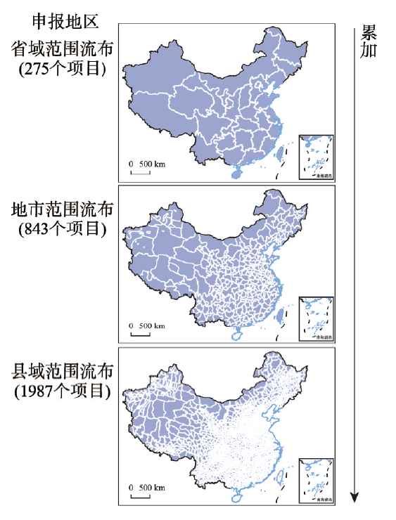
图1
基于流布范围的非遗空间分布格局分析方法示意图
注:基于自然资源部标准地图服务网站审图号为GS(2019)1835号标准地图制作,底图边界无修改。
Fig. 1
Schematic of method of analysis for acquiring the spatial distribution patterns of intangible cultural heritage based on the range of spread
2.2.2 时空演化树模型
时空数据是时空过程的产物,因此并不是一堆杂乱无章的数字沙堆,而人为界定在一维、二维或高维笛卡尔坐标系统,未必能够充分地表达出时空过程[26]。作为一种可视化手段,时空演化树建立了属性状态空间和时空格局之间的映射关系[27]。由于直接将非遗项目叠加到地图上无法同时直观有效的对空间分布、时间发育和类型丰富度及数量进行综合性分析,本文采用时空演化树模型对空间位置、形成时间、类型丰富程度、数量等多维数据进行分析,将数据中可能蕴藏的关联脉络和时空分布格局以一种简单清晰可视化的形式表达出来。在本文中,“树干”表示时间发展,按先秦、秦汉、魏晋、隋唐、宋、元、明、清、1912年至今的历史发展脉络顺序排布;一级分支按东北、华北、华东、华中、华南、西南、西北七大地理分区顺序排布;二级分支代表非遗类型,按民间文学、传统音乐、传统舞蹈、传统戏剧、曲艺、传统体育游艺与杂技、传统美术、传统技艺、传统医药、民俗十大类别顺序排布;叶片表征数量,颜色越深表示数量越多。
2.2.3 地理探测器
式中:h为变量Y或因子X的分层;N表示单元数;
3 结果分析
3.1 国家级非遗项目空间分布格局
3.1.1 总体分布特征
国家级非遗项目总体上呈现东密西疏的空间分布特征,集中分布在华北平原和长江中下游平原地区,浙江、山东、山西是国家级非遗项目数量最多的省份(图2)。国家级非遗项目中,传统技艺类占比最大,占总数的16.09%,传统体育、游艺和杂技类占比最低,仅3.94%。国家级非遗形成了以传统技艺类为主,传统体育、游艺与杂技类稀缺的结构特征。
图2
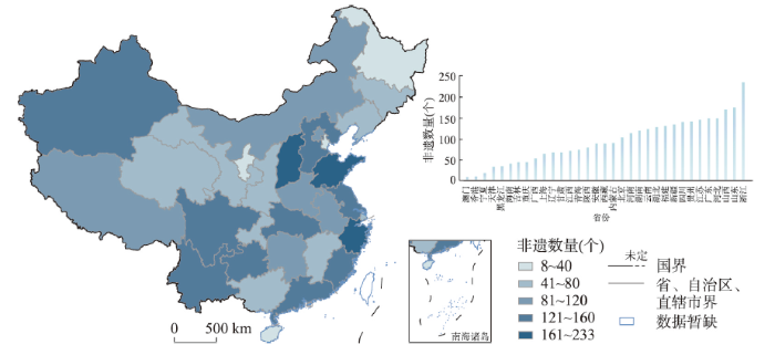
图2
2020年中国国家级非遗项目省域分布特征
注:基于自然资源部标准地图服务网站审图号为GS(2019)1835号标准地图制作,底图边界无修改。
Fig. 2
Distribution characteristics of national intangible cultural heritage at the provincial level
3.1.2 基于流布范围的国家级非遗空间分布格局
北京和西藏内部一致性较高,江浙地区呈现大分散小聚集特征,各类型非遗主要聚集在发展水平较高、民族特色突出、文化积淀深厚、自然条件优渥的地区。
图3
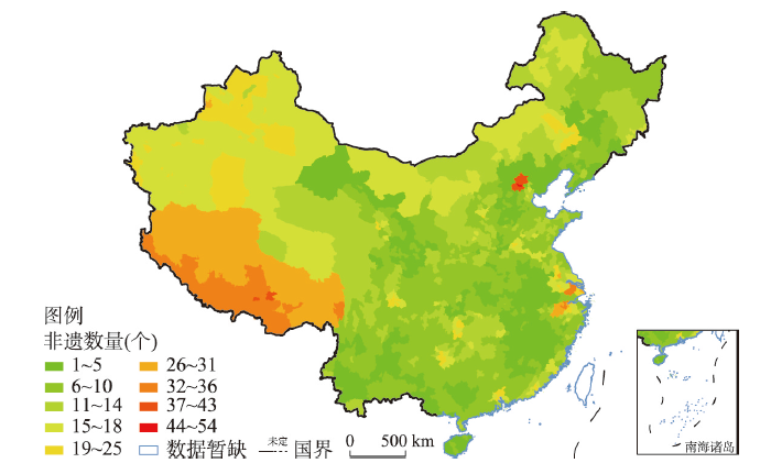
图3
2020年中国国家级非遗项目空间分布格局
注:基于自然资源部标准地图服务网站审图号为GS(2019)1835号标准地图制作,底图边界无修改。
Fig. 3
Spatial distribution pattern of national intangible cultural heritage
图4
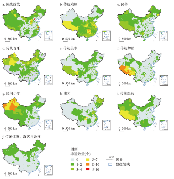
图4
2020年中国十大类国家级非遗项目空间分布格局
注:基于自然资源部标准地图服务网站审图号为GS(2019)1835号标准地图制作,底图边界无修改。
Fig. 4
Spatial distribution pattern of national intangible cultural heritage by type
结合省域分布特征和各类型非遗分布特征可以发现,北京和西藏的非遗项目总数虽不多,但拥有数量较多的流布范围较广的非遗项目(北京39项全市流布,西藏29项全区流布),区域内一致性和文化认同感较高。西藏特殊的自然地理条件使其形成一个相对封闭的环境,受到的外界干扰相对较少,文化生态系统相对稳定,因此区域内部一致性和文化认同感相对更高,民族特色十分鲜明。北京有着3000年的城市史和800年的建都史,从元大都开始,历经元明清三代形成独具特色的都城文化[30],且由于近数百年来都是中国的政治、经济、文化中心,文化形态保存较好,因此区域内一致性和认同感较高。江浙地区的非遗项目数量总体较多,但在全省范围流布的非遗项目数量较少,集中于市域流布,在空间上呈现大分散小聚集的特征,主要聚集在杭州、苏州、扬州等地。山东、山西的非遗项目数量较多,但省内分布较为分散,全域流布的非遗项目较少,各县(市、区)的独立性较强(表1)。
表1 基于流布范围的国家级非遗项目空间分布特征
Tab. 1
| 类型 | 集中流布区 | 数量最多 的省份 | |
|---|---|---|---|
| 内部一致性较高的区域 | 大分散小聚集地区 | ||
| 传统技艺 | 北京 | 江浙、山西的部分区域 | 浙江 |
| 传统戏剧 | 湖南、江苏、上海、西藏 | 陕西南部、山东西部的部分区域 | 山西 |
| 民俗 | 西藏 | 贵州、新疆、内蒙古、海南的部分区域 | 贵州 |
| 传统音乐 | 新疆、内蒙 | - | 湖北 |
| 传统美术 | 西藏、北京 | 江苏、广东的部分区域 | 广东 |
| 传统舞蹈 | 西藏 | - | 西藏 |
| 民间文学 | 新疆 | 浙江的部分区域 | 山东 |
| 曲艺 | 天津、黑龙江、重庆 | 浙江、江苏、山东、四川的部分区域 | 浙江 |
| 传统医药 | 西藏、上海 | 新疆、青海、内蒙、广东、贵州、浙江的部分区域 | 浙江 |
| 传统体育、游艺和杂技 | 北京 | 河北的部分县(市、区) | 河北 |
3.2 国家级非遗项目谱系年代
3.2.1 非遗谱系年代研究的意义讨论
非物质文化遗产指各族人民世代相承的、与群众生活密切相关的各种传统文化表现形式和文化空间[4]。建立国家级非物质文化遗产代表作名录的目的之一是要“推动我国非物质文化遗产的抢救、保护与传承,加强中华民族的文化自觉和文化认同,提高对中华文化整体性和历史连续性的认识”。因此,国家在评选非遗代表性项目时,具体评审标准包括“具有展现中华民族文化创造力的杰出价值”“扎根于相关社区的文化传统,世代相传,具有鲜明的地方特色”“具有促进中华民族文化认同的作用”“是文化交流的重要纽带”“具有见证中华民族活的文化传统的独特价值”“对维系中华民族的文化传承具有重要意义”[4]等。这些标准强调非遗项目需要具备久远的历史传统和活态传承的存续状况,传承脉络或谱系清楚,其历史价值是重要的一个维度。虽然非遗项目是现有话语体系下评定出来的产物,但重要的是,它还是历史积淀的产物,是中华文明绵延传承的生动见证,其起源和发展在时间维度上具有一定差异性。从历史起源和发展的视角考察非遗,对非遗项目谱系年代进行研究,能帮助了解非遗空间分布格局形成的原因、流传的路径,帮助我们提高对中华文化整体性和历史连续性的认识。
3.2.2 源于唐宋、明清时期的非遗项目数量较多,其中清朝最多
将中国历史时期划分为先秦(夏商周)、秦汉、三国魏晋南北朝(简称魏晋)、隋唐(包括五代十国)、宋、元、明、清、1912年至今共9个阶段,分别统计源于各历史时期的国家级非遗项目总数。总体上,源于唐宋、明清时期的非遗项目数量较多,源于三国魏晋南北朝、元朝以及1912年至今的非遗项目数量较少,其中源于清朝的非遗项目数量最多(图5)。在类型上,魏晋南北朝因当时道教和佛教的快速增长[31]而存续了不少以宗教文化为主题的非遗项目,石雕艺术也在这一时期得到极大发展[32]。木雕艺术和陶瓷烧制技艺在隋唐时期呈现蓬勃发展的新局面,而织造、纺织技艺多源于宋元。民俗活动兴盛于唐宋,鼎盛于明清。此外,戏曲在明清出现新的发展阶段,是源于明清的非遗项目中最主要的类型,明清共存续345项传统戏剧类非遗项目和153项曲艺类非遗项目,分别占该类型总数的86%和94%。
图5
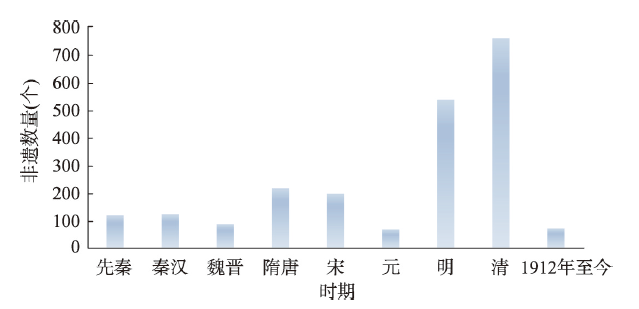
图5
国家级非遗项目谱系年代分布
Fig. 5
Chronological distribution of national intangible cultural heritage
3.2.3 魏晋时期非遗分布重心南移,自明起以华东为核心区、以华北为次核心区的非遗分布格局确立并延续至今
源于先秦时期的非遗项目主要分布在黄河中下游地区。秦汉时期由于运河的开凿,地区间经济联系加强,黄河中下游地区城市蓬勃发展[33],加之地方官员尤其是东汉循吏大力开发,江南地区经济也得以缓慢却持续稳定的增长[34],山东、江苏成为源于秦汉的非遗项目的分布核心区。此外,随着汉朝对匈奴战争的节节胜利,西北边疆得以开拓发展[35],西北地区源于这一时期的非遗项目数量也大幅增加。三国魏晋南北朝时期,由于战乱和瘟疫频发,社会环境不稳定,北方流民大量南迁,南方得以发展[36],源于这一时期的非遗项目分布重心由黄河中下游地区移向长江中下游地区(尤以浙江、江苏为甚)。隋唐时期,浙江等华东地区存续的非遗项目数量最多且类型丰富,此外,随着与西域、吐蕃的往来日益繁盛,隋唐时期西南、西北地区的文化也得以迅速发展,尤其是当时的吐蕃。吐蕃王朝的稳定繁荣使其成为西藏文化最开放的兴盛时代[37],也是西藏存续非遗项目最繁盛的时期,西藏源于隋唐时期的非遗项目数量约占源于各历史时期非遗项目总数的三分之一。与此同时,在这一时期,福建得到了更大范围的开发,隋唐五代成为福建历史发展的转折时期,源于这一时期的福建非遗也得到了较大发展[38-39]。宋朝,宋金、宋元的对峙以及黄河流域生态环境的恶化,促使北方民众一次次南迁[36],以浙江为中心的华东地区是源于宋朝的非遗项目的主要分布区,此外,加之华南地区经济的快速发展,福建、广东的源于两宋时期的非遗项目也得到较大发展。元朝在北方游牧民族的统治下,全国政治中心北移,北方文化得到新的发展。此外,元朝非常重视对西南边疆民族地区的开发和治理,在蒙元的积极经营下,西南边疆快速发展,留存了较多的源于该时期的非遗项目[40⇓-42]。源于明朝的非遗项目的分布实现了全覆盖,华东地区依然是非遗项目的核心聚集区,其次是经济得以恢复的华北地区。清朝,京杭大运河沿线和沿海地区存续的非遗项目数量进一步增多,华东和华北地区存续的非遗项目数量占总数的50%以上,依然是非遗形成发展的最核心区域,且这种分布格局一直延续至今(图6、图7)。
图6
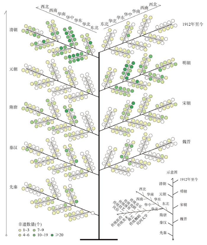
图6
国家级非遗项目时空演化树
Fig. 6
Evolution tree of national intangible cultural heritage
图7
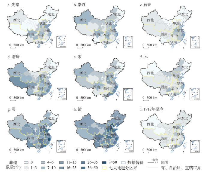
图7
源于不同历史时期的国家级非遗项目空间分布特征
注:基于自然资源部标准地图服务网站审图号为GS(2019)1835号标准地图制作,底图边界无修改。
Fig. 7
Spatial distribution characteristics of national intangible cultural heritage originating from different historical periods
3.3 影响因素分析
文化是一个在特定的空间发展起来的历史范畴[18],不同的地理生活环境和不同的历史发展阶段孕育着独特的文化类型,并呈现出显著的地域性特征。非物质文化遗产作为文化的重要组成部分,其形成和分布受自然地理环境和人文要素共同影响。本文以进行空间解构后的非遗项目数量为因变量,选取近地面气温、近地面空气比湿、近地面全风速、地面降水率、坡度、高程、NDVI、径流量、非遗保护专项资金、路网密度、文化和传媒财政支出、城镇化率、人均GDP、人口密度为自变量指标,利用地理探测器识别非遗项目空间分布的影响因子,同时将非遗空间分布格局与自然及人文要素的空间分布格局进行叠加统计以做进一步的分析。此外,由于历史文化因素衡量标准复杂多元,无法选取合适数值表示,故定性分析各历史文化要素对非遗项目空间分布特征和非遗分布重心变动的影响,以期可以在更宏观层面、更大地理单元上直观地理解影响非遗项目分布的主要因素。
3.3.1 非遗分布密集区的地理环境特征
运用地理探测器识别非遗项目空间分布的影响因子,结果表明:近地面气温、地面降水率、近地面空气比湿、径流量、非遗保护专项资金、路网密度、文化和传媒财政支出、城镇化率、人均GDP、人口密度的影响较显著,近地面全风速、坡度、高程、NDVI的影响不显著,其中,非遗保护专项资金的影响较大。
统计结果表明,较多的非遗项目聚集在多年平均近地面空气比湿在6~12 g/kg,近地面气温在10 ℃以上,地面降雨率大于0.06 mm/h的区域,也就是说非物质文化遗产多分布在湿润温暖的地区。水资源丰富的地区也是非遗项目数量较多的地区,分布在平水、多水、丰水带的非遗项目数量比重高达89%。另外,特殊的自然地理条件还会孕育特殊的非遗,比如二十四节气、藏族天文历算等非遗项目的形成依赖于区域气候条件,川江号子、河图洛书等依托于当地水文条件而产生。
人是文化产生和发展的根本推动力,人口的聚集带来文化的诞生。非遗分布密集区多分布在人类活动频繁的人口密集区、经济发达地区和交通便利地区。此外,地方对文化的重视程度与保护水平关系着非遗的挖掘、发现、申报、认定和发展。总体来看,地区文化和传媒财政支出较高、非遗保护专项资金较多的地区,非遗项目数量通常也较多。这两项指标从侧面反映了一个地区对文化的重视程度及保护水平。由于非遗具有无形性、活态性、脆弱性特征,其挖掘、保护、传承和发展的难度较大,通常来说,对文化越重视、对文化发展投入越多的地区,对非遗的挖掘和保护力度更大,申报积极性也更强,因此非遗项目的数量也更多。
3.3.2 非遗分布重心变迁的影响因素
(1)自然因素。自然因素是先民赖以生存、发展的环境基础,是一个由多要素构成的彼此联系、相互作用的整体[43],其对非遗总体分布特征的影响是基础性的。
近两千年来,中国气候的总趋势是逐渐变冷[44]。早期黄河流域气候较今温暖湿润,低温和干旱威胁较轻,是森林茂盛、水土肥沃、雨水充沛、气候适宜的富饶之地,再加上黄土的特性和平坦的地形,易于开垦耕种,适宜人类生存和生产,成为早期的人口分布重心,文化发展更为繁荣,文明程度更高。相形之下,长江流域当时过分炎热潮湿,疾病易于流行,加之土壤黏密、地形复杂、山岭崎岖、湖沼众多,导致开垦困难,不如黄河流域宜居,其早期经济文化发展落后于黄河流域[43,45]。《汉书·严助传》记载,汉武帝遣两将军将兵诛闽越,淮南王刘安上书谏止,认为“南方暑湿,近夏痒热,暴露水居,蝮蛇篇生,疾病多作”,这样的恶劣气候会导致军队大量减员[46]。但随着气候变冷,长江流域及其以南的气候变得更适于人类居住和生产生活。据王子今[46]考证,至东汉中期以后,南方气候环境逐渐转好,更切合中原人所谓“风雨顺节”的评断。这为人口南迁进行生产生活活动奠定了环境基础。相反,黄河流域气候逐渐趋于寒冷干燥,水体减少,且由于过度开发,导致生态环境破坏严重,森林被毁、水土流失、土地沙化、泥沙淤积、水患频发、土壤贫瘠,生态环境发生巨大改变,加之战乱频繁,导致人口大量南迁,重心移至长江流域,非遗的分布重心也随之从黄河流域移向长江流域。
(2)人文因素。影响非遗项目分布重心变动的因素是多元的,自然要素的影响是基础性的,而改变其变化强度和迁移方向的最重要因素则是人类活动[47]。
① 人口迁移。文化是人精神世界和意识形态的体现,人是文化产生和发展的根本推动力。人口的聚集带来文化的诞生,人口的迁移和增长带来文化的交流碰撞和繁荣兴盛。从历史发展来看,人口峰值的变化与非遗数量的变化呈现一致性,人口数量越多的历史时期,存续的非物质文化遗产的数量通常也越多(图8)。
图8
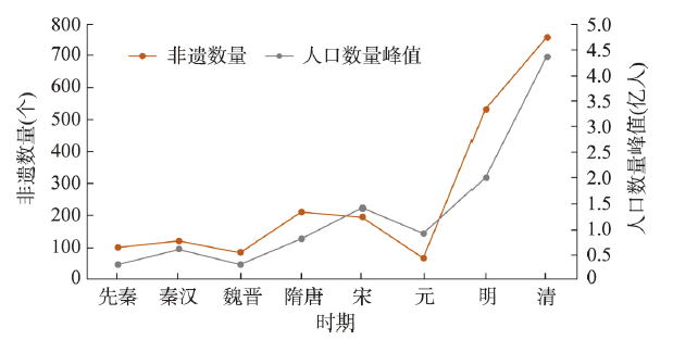
图8
历史人口峰值与源于不同历史时期的非遗数量
Fig. 8
Historical population peaks and the number of intangible cultural heritage projects originating from different historical periods
从中国古代人口分布来看,秦汉时期,人口主要集中于黄河中下游和淮河下游地区[48],源于该时期的非遗项目主要集中在山东、江苏。此外,随着对匈奴战争的节节胜利,西域归入中原版图,为加强边疆建设,朝廷积极实行移民实边、兴办屯田的政策,例如汉武帝向西北边疆移民达70余万[36]。这些移民既是建设边疆的劳动生产者,同时也是中原文化和先进技术的推广传播者,他们凭借较高的生产劳作技术和经验,使得西北地区得以发展,经济文化交流得以增强[49],西北地区源于这一时期的非遗数量也在增加。魏晋时期,战乱频发,人口大规模地从黄河流域流向长江流域,北方流民的南下,大大增加了南方的劳动力,给南方带来了先进的生产技术[48],长江流域被迅速开垦和发展起来,长江中下游地区源于这一时期的非遗项目数量得以增加,非遗分布重心由黄河中下游地区转向长江中下游地区。隋朝统一后,北方人口约占全国人口的70%,但唐中期后,由于战乱频发,人口重心南移至长江流域。唐元和年间,秦岭淮河一线以北地区的人口占比降至32%,以南地区人口占比上升至68%[48]。宋朝,宋金、宋元的对峙以及黄河流域生态环境的恶化,使得北方广大地区的人民不堪忍受残酷的统治和民族压迫,被迫从黄河流域大量向南方迁徙。同时,南方相对稳定的社会环境和大量尚未开垦的良田土地吸引了大批王公贵族、官员百姓纷纷涌向南方。“中原士民,扶携南渡,不知几千万人”。北方民众一次次南迁,带来了大量劳动力与先进的技术,人口分布南重北轻的特点日益凸显[50]。自此,华东地区(尤其是江浙一带)成为非遗分布的稳定核心地带,华南地区源于唐宋时期的非遗项目数量也有所增长。元明时期,湖南、山西、四川等地的大量民众迁往云贵,各族百姓杂居相处交往交融,使贵州地区的社会经济及文化迎来新的发展[40⇓-42]。明朝前期,为恢复北方的社会经济系统,巩固新政权,数拨移民迁往北京、河北、河南、山东等地[36],尤其在永乐年间,陆续从江苏、山西、山东、湖广等地多次向北直隶移民,由此引发了明代向京津所在的海河流域中下游的大移民浪潮[51],华北地区人口增加,相应的,起源于明朝的非遗数量也在增加,成为仅次于华东的次核心区。
具体到非遗项目看,众多非遗项目都带有人口迁移留下的印证。泉州傀儡戏,古称“悬丝傀儡”,今称提线木偶戏,于晋唐时随中原移民南迁入闽[52]。福建省中部大田县的国家级非遗“大田板灯龙”源于唐末,据玉田村范氏族谱记载,天祐元年(904年),中丞御史范元超因朝纲不振,辞官携眷辗转南迁,定居于闽中腹地大田均溪河畔。祖居江宁、流落异乡的范元超,每逢元宵佳节,总会忆起金陵古都灯火穿梭、龙舟竞渡的江夜胜景,于是制作了“旱龙”以慰藉思乡之情,从而有了“大田板灯龙”的雏形[53]。山西的大槐树祭祖习俗见证了中国历史上规模最大的移民运动,其中以明代洪武初年至永乐十五年之间的50余年为高潮(共18次从山西迁出移民)。这场中国历史上规模最大的移民运动,它直接涉及1230个姓氏和汉、回、蒙古等多个民族,移民迁徙地遍及全国18个省(市)的498个县(市)[52]。贵州安顺的屯堡文化来源于明朝朱元璋大军的“调北征南”,这使得屯堡人的文化中保留了诸多江南的文化特质,比如广负盛名的安顺地戏。安顺地戏的传承虽源自江南,但经屯堡人移植于黔中以后生根发芽,枝繁叶茂,“成为贵州境内堂戏班子最多、剧目独特、唱腔古老、面具个性鲜明、数量惊人的民间傩戏”[54]。
② 经济发展。区域经济社会要素是影响非遗形成与分布的重要因子,经济社会的大发展往往是文化繁荣兴盛的重要推动力量。从历史时期看,据《史记·货殖列传》记载,战国秦汉时期,全国经济都会共有27处,多集中于黄河流域,其中,崤山以东15处,崤山以西7处,其余在江南地区。至东汉永和年间已形成郡县二级城镇体系,其中40%分布于黄河中下游地区,14%分布于淮河流域[48],是全国的经济重心,农业和手工业发展迅速,良好的经济社会条件促进了文化的产生和发展,在这一时期,黄河流域和淮河流域的广大地区,如山东、江苏,是源于秦汉的非遗项目的分布核心区。秦汉对西北边疆的治理促进了西北地区经济的发展。晁错称“要害之处,通川之道,调立城邑”,这一计划在西北地区付诸实施,河西的金城、武威、张掖、酒泉、敦煌均建于要害之处、通川之道,朔方、五原、云中、渔阳、上谷,莫不如此。这些城镇的兴建,促进了地区经济的稳定发展,还起着对外经济交流的作用——南通印度,西通中亚、西亚,远至地中海、欧洲,而这也带来了文化上的广泛交融[49]。新疆和田地区洛浦县的手工地毯是当地著名的工艺品,目前有16种传统样式,其中伊朗努斯卡系从伊朗传来,阿拉班尼努斯卡系从阿塞拜疆传来,扎伊乃玛子努斯卡是随伊斯兰教传入的祈祷毯[52]。魏晋时期的长期动乱和战争给黄河中下游地区的社会经济秩序带来严重破坏,是中国古代城市经济最衰落的时期[33],文化的发展也受到冲击,黄河中下游地区不再是源于这一时期非遗项目分布的最核心地带。隋唐时期,大运河和长江沿岸因水运便利兴起一批城市,经济重心进一步南移,扬州、益州(今成都)的经济地位超过长安和洛阳[48],长江流域尤其是江南地区成为非遗分布的稳定的核心地带。公元7世纪藏王松赞干布统一了分散部落建立了吐蕃王朝,并不断加强与邻近的印度及中原唐朝等地的交流与合作,积极进行社会经济发展和文化开发,推动了藏地文化的相互交流,实现了藏地文化的整合与发展,松赞干布时期成为西藏文化最开放的兴盛时期[37],也是西藏存续非遗项目最繁盛的时期。在源于这一时期的许多藏族非遗中,我们均可看到藏汉文化交融的身影。比如藏族造纸技艺源自唐朝文成公主远嫁吐蕃时传入的中原造纸术,藏族人民出于译经需要,在此基础上不断改进,融入地方原材料,生产出了独具特色的藏纸[52]。五代十国战乱割据中闽国的出现是华南地区重要的历史转折,不仅改变了人们对南海山区蛮荒的普遍认知,还逐渐以经济繁荣、文化发达闻名于东南,两宋以后还以经济发展先进地区的优势辐射影响全国[39,55]。官营经济的引入促进华南地区造船、制香、制茶等手工业的发展;面对海洋的开放政策,广州、泉州等东南沿海港口城市快速发展,成为商业最发达的区域[55]。曾在历史中一直处于非遗分布稀缺区的东南沿海地区存续的非遗数量在这一时期得到新的发展。明朝前期多次的移民活动加速了华北地区农业经济的恢复和繁荣。明清时期社会的安定繁荣局面为文化的繁荣兴盛提供了物质基础,带动了南北方文化的交流与融合,文学、戏剧、曲艺、美术、杂技、手工艺、民俗活动等文化形态百花齐放,华北地区也由此成为非遗分布的另一重心。
③ 战乱灾害。战乱灾害对非遗分布重心变动的影响主要体现在两方面。一是在战乱和灾害频发的历史时期,人民生产生活活动受到极大制约,民众的生存难以为继,文化的发展亦受到严重阻碍,非遗很难在这样的历史背景下形成并得以发展延续。东汉末年和魏晋时期的战争动乱给黄河流域城市的社会经济秩序带来严重破坏。“名都空而不居,百里绝而无民者,不可胜数。”黄河流域原有的城市体系遭到严重破坏。北宋时期黄河河患十分严重,从10世纪初至11世纪40年代(五代末至北宋庆历年间)的140年中,决溢共95次,给黄河下游平原城市带来严重影响[33]。此外,与辽、夏的战争对黄河流域城市经济社会发展的负面影响也颇为巨大。灾害和战乱使得黄河流域城市经济发展远不及南方。在这样的背景下,黄河中下游地区的非遗的保护、传承和发展受到极大阻碍,非遗分布重心逐渐转向经济社会更加稳定繁荣的南方。二是政权变更、动乱爆发以及政治中心转移等成为激发都城及其附近地区移民浪潮的最主要的动力源[56],也因此使得文化的重心随之变化。历史时期发生的最著名的三次大规模移民运动——魏晋“永嘉南渡”、唐代“安史之乱”之后的人口迁移以及北宋“靖康南渡”——均由政治动乱引起,也因此改变了中国人口分布格局,且由于移民中增加了皇族、官僚等统治阶级的上层人士和文人学士、艺人工匠等,南方的文化水平得以提高[46],文化发展迅速,非遗的分布重心也随之改变。
4 结论与展望
4.1 结论
本文通过采用基于流布范围对非遗进行空间解构的方法从宏观尺度解析了非物质文化遗产的地方文化认同和区域一致性,为非遗空间格局分析方法的改进以及非遗地方认同的研究提供了新的思路和参考。同时,通过对非遗项目谱系年代的分析,探索了非遗空间分布重心变迁的历史过程及结构性动力,对于提高对中华文化整体性和历史连续性的认识具有一定价值。主要结论如下:
(1)国家级非遗主要聚集在发展水平较高、民族特色突出、文化积淀深厚、自然条件优渥的地区,华北平原和长江中下游平原是国家级非遗的聚集中心。基于非遗流布范围的空间解构结果表明,北京和西藏文化形态保存较好,内部一致性和文化认同感较高;江浙地区的非遗项目集中在苏州、杭州、扬州等城市,在空间上呈现大分散小聚集的特征。
(2)源于各历史时期的非遗项目的分布重心总体上呈现自西向东、自北向南的变化路径。自魏晋时期至宋,随着人口的大规模南迁,存续非遗项目的分布重心从黄河中下游和西南、西北、华中地区逐步转移到长三角,形成了以长三角为中心的稳定的华东非遗分布核心。明朝后,随政治中心的北移和系列恢复北方经济的举措,华北地区形成并存续的非遗数量占比逐渐增大,自此,形成了以华东为核心区、以华北为次核心区的非遗分布格局,并延续至今。
(3)自然要素对非遗项目分布的影响是基础性的,而改变非遗分布重心变化及变化速度与强度的最重要因素则是人类活动。总体看来,国家级非遗多分布在湿润温暖、水资源较为丰富、人口密集、经济发达、文化受重视程度高的地区。生态环境的变化、人口的迁移、经济发展格局的变动、政治中心的转移和战乱灾害的发生是促使非遗分布重心转移的关键因素。
4.2 讨论
(1)非遗代表性项目名录是目前唯一可获取的可靠的官方的非遗分析数据来源,当前尚未有未列入名录的潜在非遗资源数据库,目前学界对非遗从宏观和整体上进行的研究均基于非物质文化遗产代表性项目名录。该数据是各地非物质文化遗产的代表,能够较大程度地反映中国非遗现状,但仍存在一定局限性,未来需要对非物质文化遗产的调查记录及评定加强研究。
(2)在非遗项目谱系年代分析部分,本文按照非遗的起源时间进行分析,但事实上,可能存在小部分项目现流布地与诞生地不一致的现象。由于资料和数据的限制,我们现阶段无法对每一个非遗的形成发展过程进行详细梳理,因此,只能从宏观上梳理非遗的空间分布重心变动过程。未来将尝试对这部分内容进行微观分析。
(3)非物质文化遗产是活态的文化和历史积淀产物,它根植于其生长的自然和人文环境并处于不断地变化之中,其影响因素及作用机制纷繁复杂且互相交织,涉及政治、军事、经济、社会、文化、自然生态等方方面面。目前对非遗时空演化影响机制的研究还存在诸多难点,本文仅在更宏观的层面和更大地理单元上直观地理解影响非遗分布的主要因素,对影响机理的分析还需要不断的去探寻和钻研。
(4)基于国家级非遗项目空间分布及谱系年代特征,对非遗及中国区域文化的保护发展有以下几点建议:① 加强非物质文化遗产的评定研究,完善非遗的认定机制,提高地方非遗项目申报的积极性,加大非遗项目保护资金投入,提高非遗保护力度,重点加强西部地区、少数民族地区非遗资源的挖掘和开发利用,给予适当的政策倾斜。② 要发挥高校和研究机构力量加大对非遗的研究力度,加强非遗历史发展演化研究,阐释其蕴含的中国文化基因及其在中华文明传承发展中的地位、作用和价值。③ 非遗根植于其所生长的地理环境,不同地域有不同的生活方式,形成不同的文化,产生各具特色的非遗,地方性是区域发展的文化力或文化软实力[57],因此在非遗保护中要始终体现因地制宜、分类指导、多样保护的原则,深入挖掘地方性,比如黄河流域应着重加强对涉及文明起源文化发祥的非遗项目的保护和研究,尝试建立中华文明基因的种子库。④ 每一种非物质文化遗产与孕育它的民族、地域生长成一个文化综合体,是文化生态系统的核心要素,因此对于非遗的保护传承,不能脱离于其孕育发展的人文环境和自然环境,应在发展中明确区域文化竞争力,以人为本地推动文化遗产的整体性保护,维护文化生态系统的平衡和完整。
致谢
感谢高松凡老师、徐成东老师、陈子华师兄,以及各位审稿专家在论文写作过程中给予的意见和建议。
参考文献
Intangible cultural heritage: The living culture of peoples
DOI:10.1093/ejil/chr006 URL [本文引用: 1]
Interim Measures for the Application and Evaluation of National Intangible Cultural Heritage Representatives
[EB/OL].
国家级非物质文化遗产代表作申报评定暂行办法
[EB/OL].
Interpretation and reconstruction of the concept of intangible cultural heritage
非物质文化遗产概念的诠释与重构
A series of studies on intangible cultural heritage: The concept and components of intangible cultural heritage
非物质文化遗产系列研究(一): 非物质文化遗产的概念与构成要件
Safeguarding intangible cultural heritage: Key factors in implementing the 2003 convention
Intangible cultural heritage: Safeguarding for creativity
DOI:10.1016/j.ccs.2012.10.003 URL [本文引用: 1]
On the spreading and spreaders of non-material cultural heritage protection
论非物质文化遗产保护中的传承及传承人
Thoughts on the basic ideas and models of the construction of cultural and ecological reserves
关于文化生态保护区建设基本思路和模式的思考
The protection and utilization of the intangible cultural heritage in the context of digitization
数字化背景下非物质文化遗产的保护与利用
A brief discussion on the digital protection and inheritance of intangible cultural heritage
非物质文化遗产数字化保护与传承刍议
Roles of intangible cultural heritage in tourism in natural protected areas
DOI:10.1080/1743873X.2016.1245735 URL [本文引用: 1]
Productive protection and derivative product development of intangible cultural heritage
非物质文化遗产的生产性保护与衍生产品开发: 基于传承与传播的探讨
Spatial-temporal distribution characteristics of the intangible cultural heritage in Hubei Province
湖北省非物质文化遗产的时空特征研究
Spatial-temporal characteristics and evolution of intangible cultural heritage in the Yangtze River Economic Zone
长江经济带非物质文化遗产的类型时空特征及演化
The spatial distribution and relevant factors of China's different types intangible cultural heritages
中国不同类型非物质文化遗产的空间分布与成因
Geographical distribution and affecting factors of the intangible cultural heritage in China
DOI:10.13249/j.cnki.sgs.2013.010.1166
[本文引用: 2]

:Intangible cultural heritage is defined as a spectral cultural heritage that has important historical and art values. Research on the geographical distribution and affecting factors of the intangible cultural heritage in China is important for the improvement of heritage protection and management. Data from 2 376 items concerning intangible cultural heritage in China are collected on a national level and analyzed based on the Geographic Information System. Research shows that the structural types of intangible cultural heritage in China can be divided into three classes. The first class includes traditional craft and traditional opera. This class is considered the most predominant class among the intangible cultural heritage classes in China. The second class, which is less predominant, includes traditional music, customs, dancing, art, and literature. The third class, which is the least predominant among the classes, includes traditional physical education, medicine, and drama. Numerous types of intangible cultural heritage exist in China that were influenced by the nationality and rationality of the population. Most of these types of heritage can be found in the rich history, popular culture, and minority regions of China. The structural level of the heritage is unbalanced and exhibits zone and block shapes. The intangible cultural heritage in China is mainly distributed in the Eastern and Middle regions, whereas only a few are distributed in the Western region. The number and density of intangible cultural heritage in Southern China are bigger than that in Northern China. Intangible cultural heritage in China is also preserved by communities along the Changjiang River. Heritage distribution has a certain correlation with big river systems. The number and density of intangible cultural heritage is greatly unbalanced in the Eastern, Middle, and Western regions of China. Eastern China has the highest density of intangible cultural heritage followed by Middle China and Western China. Intangible cultural heritage is highly dense in Eastern China and sparse in Western China. The factors that affect the distribution of intangible cultural heritage are as follows. First is the geographic environment. More intangible cultural heritage can be found in areas rich in products and human activities. Second, the distribution of intangible cultural heritage has certain correlations with livable environmental conditions and minority regions because these areas are characterized by long histories and rich cultures. Third, minority regions along border areas are subjected to less cultural invasion. Although intangible cultural heritage items are divided in this paper to assess their precise spatial distributions, distinguishing these items is difficult because of carrier movement. The evaluation of intangible cultural heritage by the National Cultural Relics Administration is also limited. Thus, research on evaluation of intangible cultural heritage should be reinforced in the future.
中国非物质文化遗产的空间分布特征及影响因素分析
DOI:10.13249/j.cnki.sgs.2013.010.1166
[本文引用: 2]
研究中国非物质文化遗产的空间分布特征及影响因素, 是提高非物质文化遗产的管理和保护水平的重要路径。通过GIS空间分析技术研究了2 376项中国国家级非物质文化遗产项目(台湾地区除外)。研究表明:非物质文化遗产呈带状、组团状分布, 分布不均衡。从全国看,非物质文化遗产呈组团状分布在东部(尤其是东部沿海地区)和中部地区, 而西部相对稀少,呈现西疏东密的空间分布;从南北看, 南方分布数量与密度均大于北方,且主要分布于长江流域带。影响空间分布的主要原因: 一是受地理大环境的影响,物产丰富和人类活动较多的地区非物质文化遗产较多; 二是与人类的宜生环境和民族性地域性有关;三是少数民族聚居区,由于地处边疆,较少受到外来文化的入侵,文化传统不易被破坏。
Spatial distribution characteristics of the intangible cultural heritage in China
中国国家级非物质文化遗产的空间分布特征及影响因素
Spatial distribution of traditional villages and influence factors in Hunan Province
Geographical distribution of the intangible cultural heritage in Shanxi province
山西省非物质文化遗产空间分布格局及影响因素探析
Analysis of structural characteristics and spatial distribution of the national intangible cultural heritage in China and its policy implications
Spatiotemporal data analysis in geography
DOI:10.11821/dlxb201409007
[本文引用: 1]
Following the emergence of large numbers of spatiotemporal datasets, the literatures related to spatiotemporal data analysis increase rapidly in recent years. This paper reviews the literatures and practices in spatiotemporal data analysis, and classifies the methods available for spatiotemporal data analysis into seven categories: including geovisualization of spatiotemporal data, time series analysis of spatial statistical indicators, coupling spatial and temporal change indicators, detection of spatiotemporal pattern and abnormality, spatiotemporal interpolation, spatiotemporal regression, spatiotemporal process modelling, and spatiotemporal evolution tree. We summarized the principles, input and output, assumptions and computer software of the methods that would be helpful for users to make a choice from the toolbox in spatiotemporal data analysis. When we handle spatiotemporal big data, spatial sampling appears to be one of the core methods, because (1) information in a big data is often too big to be mastered by human physical brain, so has to be summarized by statistics understandable; (2) the users of Weibo, Twitter, internet, mobile phone, mobile vehicles are neither the total population nor a random sample of the total population, therefore, the big data sample is usually biased from the population, and the bias has to be remedied to make a correct inference; (3) the data quality is usually inconsistent within a big data, so there should be a balance between the variances of inferences made by using data with various quality and by using small but high quality data.
地理学时空数据分析方法
DOI:10.11821/dlxb201409007
[本文引用: 1]
随着地理空间观测数据的多年积累,地球环境、社会和健康数据监测能力的增强,地理信息系统和计算机网络的发展,时空数据集大量生成,时空数据分析实践呈现快速增长。本文对此进行了分析和归纳,总结了时空数据分析的7类主要方法,包括:时空数据可视化,目的是通过视觉启发假设和选择分析模型;空间统计指标的时序分析,反映空间格局随时间变化;时空变化指标,体现时空变化的综合统计量;时空格局和异常探测,揭示时空过程的不变和变化部分;时空插值,以获得未抽样点的数值;时空回归,建立因变量和解释变量之间的统计关系;时空过程建模,建立时空过程的机理数学模型;时空演化树,利用空间数据重建时空演化路径。通过简述这些方法的基本原理、输入输出、适用条件以及软件实现,为时空数据分析提供工具和方法手段。
Cities evolution tree and applications to predicting urban growth
DOI:10.1007/s11111-011-0142-4 URL [本文引用: 1]
Geodetector: Principle and prospective
DOI:10.11821/dlxb201701010
[本文引用: 2]
Spatial stratified heterogeneity is the spatial expression of natural and socio-economic process, which is an important approach for human to recognize nature since Aristotle. Geodetector is a new statistical method to detect spatial stratified heterogeneity and reveal the driving factors behind it. This method with no linear hypothesis has elegant form and definite physical meaning. Here is the basic idea behind Geodetector: assuming that the study area is divided into several subareas. The study area is characterized by spatial stratified heterogeneity if the sum of the variance of subareas is less than the regional total variance; and if the spatial distribution of the two variables tends to be consistent, there is statistical correlation between them. Q-statistic in Geodetector has already been applied in many fields of natural and social sciences which can be used to measure spatial stratified heterogeneity, detect explanatory factors and analyze the interactive relationship between variables. In this paper, the authors will illustrate the principle of Geodetector and summarize the characteristics and applications in order to facilitate the using of Geodetector and help readers to recognize, mine and utilize spatial stratified heterogeneity.
地理探测器: 原理与展望
DOI:10.11821/dlxb201701010
[本文引用: 2]
空间分异是自然和社会经济过程的空间表现,也是自亚里士多德以来人类认识自然的重要途径。地理探测器是探测空间分异性,以及揭示其背后驱动因子的一种新的统计学方法,此方法无线性假设,具有优雅的形式和明确的物理含义。基本思想是:假设研究区分为若干子区域,如果子区域的方差之和小于区域总方差,则存在空间分异性;如果两变量的空间分布趋于一致,则两者存在统计关联性。地理探测器q统计量,可用以度量空间分异性、探测解释因子、分析变量之间交互关系,已经在自然和社会科学多领域应用。本文阐述地理探测器的原理,并对其特点及应用进行了归纳总结,以利于读者方便灵活地使用地理探测器来认识、挖掘和利用空间分异性。
Temporal and spatial distribution of intangible cultural heritage and its influencing factors in Jiangsu Province
DOI:10.13249/j.cnki.sgs.2021.09.011
[本文引用: 1]
Intangible cultural heritage is the product of cultural-ecological environment, and analyzing its spatial distribution characteristics and influencing factors will help to further improve the management and protection of intangible cultural heritage. Therefore, taking Jiangsu Province as an example, the nearest neighbor index method and nuclear density estimation method are used to visualize the temporal and spatial distribution of intangible cultural heritage at the provincial level and above, and the buffer analysis method and geodetector model are used to analyze the influencing factors of the distribution of intangible cultural heritage. The conclusions can be drawn as follows: 1) There are differences in the distribution of Jiangsu intangible cultural heritage in time and space dimensions. The intangible cultural heritage in different historical stages has obvious differences in quantity and type due to the economic, cultural and political influence of the time. At the same time, the intangible cultural heritage center of Jiangsu has shown a ‘circular southward’ development trajectory in the time dimension. From the perspective of spatial distribution, the overall distribution is in a cluster shape, forming six high-density core areas, two sub-high-density core areas and six low-density core areas. 2) The temporal and spatial distribution of intangible cultural heritage in Jiangsu is affected by natural, social and economic factors. First of all, natural factors have a significant impact on the distribution of intangible cultural heritage by river systems. Secondly, the policy-oriented factors among social factors have the greatest impact on the distribution of intangible cultural heritage. The influence of historical and cultural factors on intangible cultural heritage is mainly manifested in the number, type and artistic characteristics of intangible cultural heritage. Finally, economy has a direct relationship with the generation and inheritance of intangible cultural heritage, and the economic level directly affects the degree of attention to intangible cultural heritage. The countermeasures can be proposed as follows: 1) Construct the Grand Canal Cultural Belt (Jiangsu Section) to promote the protection and utilization of intangible cultural heritage. In the process of promoting the construction of the Grand Canal Cultural Belt (Jiangsu Section), the protection and development of intangible cultural heritage along the Grand Canal should be placed under the overall planning and overall coordination of the cultural belt. 2) Attention should be paid to the overall protection of the intangible cultural heritage ‘cultural ecosystem’. The protection of intangible cultural heritage should rely on the original cultural ecosystem to establish different cultural protection areas, and carry out effective inheritance and development of intangible cultural heritage, so as to ensure the subsequent survival of intangible cultural heritage and maintain the local cultural characteristics. 3) Take a correct view of the reasonable interaction between intangible cultural heritage and the economy. On the premise of ensuring that the core of intangible cultural heritage remains unchanged, giving full play to the economic role of intangible cultural heritage and promoting the integration of intangible cultural industry and tourism will not only benefit the development of local folk economy, but the resulting economic benefits can still feed back protection and inheritance of intangible cultural heritage.
江苏非物质文化遗产的时空分布及其影响因素
DOI:10.13249/j.cnki.sgs.2021.09.011
[本文引用: 1]
以江苏为例,运用地理学相关方法将非遗的时空分布可视化,并探讨其分布的影响因素。研究表明:江苏非遗在时间上呈“迂回向南”发展轨迹,其数量和类型在不同阶段具有明显差异;在空间上呈聚集性分布,分别在苏州、扬州、南京、常州、镇江和南通形成6个高密度核心;通过地理探测器分析,得知河流水系、政策导向、历史文化和经济等因素对非遗的时空分布有较大影响。由此得出重视江苏大运河文化带建设、将非遗纳入文化生态系统内整体性保护、正视非遗与经济合理互动等启示。
The influences of regional culture on subway site design with Beijing characteristics
地域文化对北京特色地铁站点设计的影响
Research on the relationship between Taoism and Buddhism in the Wei, Jin, Southern and Northern dynasties
魏晋南北朝道教、佛教思想关系研究
The evolution of stone sculpture in Chinese buildings
中国建筑石雕的演变历程
The environmental changes and the rise and fall of the city in the Yellow River Basin in the historical period
历史时期黄河流域的环境变迁与城市兴衰
The development stages and characteristics of cities in Jiangnan in the Qin-Han dynasties
秦汉江南地区城市发展的阶段与特征
Population migration in Chinese history
中国历史上的人口迁移
A brief history of Tibetan dance
西藏舞蹈发展简史(上)
On the development of Fujian in Sui, Tang and Five dynasties and the formation of its cultural characteristics
论隋唐五代福建的开发及其文化特征的形成
The rise and continuing of Min kingdom's civilization
闽国文明的崛起及其延续
The governance of Guizhou Chieftains in Yuan Dynasty and its influence
制度、开发与认同: 元朝对贵州土司的治理及其影响
The people who had immigrated from outside in Guizhou Province in the Yuan Ming Qing period
元明清时贵州地区的外来移民
The dominion thought and administrative policy of Mongol Empire and Yuan Dynasty
蒙元经营西南边疆的统治思想及治策
Historical investigation on the influence of natural environment change on population migration
自然环境变迁影响人口迁移的历史考察
A preliminary study on climate change in China in the past five thousand years
中国近五千年来气候变迁的初步研究
On the significance of climate change in the Qin and Han dynasties to the economic and cultural development of Jiangnan
试论秦汉气候变迁对江南经济文化发展的意义
Spatio-temporal characteristics of cultural sites and an analysis of their driving forces in the Ili River Valley in historical periods
DOI:10.11821/dlxb201505010
[本文引用: 1]
This paper presents an analysis of the spatio-temporal distribution of cultural sites in the Ili River Valley in Northwest China based on the application of ArcGIS software. It further explores the relationships between the spatio -temporal evolution of the sites, human history, and the natural environment. The results indicate that the numbers and proportions of the sites, and the frequency of their occurrence, exhibited an inverted V-shaped change trend during six historical periods. These covered the initial, peak, and declining stages of six periods extending from the Xia-Western Zhou dynasties to the Qing-Modern period. The spatial distribution pattern shifted from "high in the east and low in the west" during the first three periods to "high in the west and low in the east" during the latter three periods, illustrating a change in the spatial center of gravity of human activities. The sites were mainly distributed on slopes of grades 1-5. The proportion of sites increased from 75% during the Spring and Autumn-Qin dynasties to 93.75% during the Qing-Modern period. The concentrated distribution of site elevations shifted from grades 4-8 during the Spring and Autumn-Qin dynasties, and the Western Han-Northern and Southern dynasties to grades 1-4 during the latter three periods. The number of sites showed a shifting trend from high mountains and hills to low plains, and from high slopes to low slopes. In particular, the evolutionary pattern of sites in the study area exhibited a special "moist" pattern of migration from middle and upstream areas to downstream areas, as opposed to the migration pattern of sites located in typical arid areas. The paper also includes a discussion of factors influencing the distribution and spatio -temporal evolution of cultural sites, notably, human factors such as politics, economy, and productivity, and natural factors such as geomorphology, altitude, slope, and climate. Although the distribution and spatio -temporal evolution of cultural sites exhibited an orientation toward natural laws pertaining to factors such as river valleys, terraces, plains, and water resources, they presented a significant orientation toward laws, relating to human-driven forces including productivity levels, political stability, economic development, business and trade, and transport, which were more evident during the latter historical periods.
历史时期伊犁河谷文化遗址时空特征及驱动力分析
DOI:10.11821/dlxb201505010
[本文引用: 1]
运用ArcGIS软件对伊犁河谷文化遗址时空分布进行分析,探讨了遗址时空演变特征与人文历史、自然环境的关系。结果表明:① 从夏—西周到清—近现代6个时期中,遗址数量及在总数中的比重、出现频率呈倒“V”型变化,从萌芽阶段到巅峰阶段,至衰落阶段。② 遗址的空间分布格局由前3个时期的“东高西低”转变为后3个时期的“西高东低”,人类活动空间重心发生了转移。③ 遗址主要分布在1~5级坡度上,其比重由春秋—秦时期的75%增至清—近现代时期的93.75%;而遗址集中分布高程则由春秋—秦和西汉—南北朝时期的4~8级转移到后3个时期的1~4级,且其数量表现出明显的从高海拔的山地丘陵向低海拔平原、从高坡度向低坡度转移。④ 研究区遗址演变模式与典型干旱区遗址迁移模式相反,表现为特殊的“中上游→下游”迁移的“湿润模式”。⑤ 研究区文化遗址分布、时空演变受政治、经济、生产力等人文因素和地貌、海拔、坡度、气候等自然因素的综合影响。由于其气候湿润,水资源丰富,虽然遗址分布和演变表现出一定的河谷谷地、阶地、平原、水资源等“自然因素”指向性规律,但更突出表现为生产力水平、政治稳定、经济发展、商贸交通等“人文力量”指向性规律,这一点在中后期表现得更为明显。
Changes of the physical and human geographical environment in China during the past 2000 years
DOI:10.11821/dlxb202101001
[本文引用: 5]
Understanding the changes of physical and human geographical environment during the past 2000 years in China is beneficial to establish the position, direction, focus areas, and initiatives of "Beautiful China" construction. In this paper, we integrated the results published in research papers, summarized the general characteristics of geographical environment changes in the history, and explored the implications of these changes on the construction of ecological civilization. The results implied that historical changes in China's land surface had been mainly manifested by the multi-scale quasi-periodic fluctuations and regional differentiation of climate, the fragmentation of the Loess Plateau, the expansion of desertified land in the northern regions, the gradual migration of delta coasts, the large scale shrinkage of lake systems especially in the Yellow River and the Yangtze River basins, and the decline in area of forests and the grasslands of northern China. Meanwhile, the economic and social changes were prominently reflected in the population growth and pattern changes, the migration of economic center to the southeast, the expansion of cultivated land to the periphery, and the transportation network evolution. From the above results, we could achieve the following enlightenments: in the future, the deserts in the northern region would still exist, and the lake systems in the middle and lower reaches of both the Yellow River and the Yangtze River were difficult to restore. The grain transportation from the south to the north disappeared in the history. But there was still much room for improvement in the coverage rate of forests, the transportation network could still achieve a higher level, and at the same time, we must mitigate the risk from climate change in the coastal cities.
两千年来中国自然与人文地理环境变迁及启示
DOI:10.11821/dlxb202101001
[本文引用: 5]
科学理解中国自然与人文地理环境变迁的历史逻辑、基本规律和发展趋势,有助于找准历史方位,确立国土空间开发保护格局优化方向,推进“美丽中国”建设与经济社会可持续发展。本文集成现有研究成果,梳理了两千年来中国自然与人文地理环境变迁过程,总结了主要要素的变迁特点,探讨了这些历史变迁对“美丽中国”建设的启示。研究表明,两千年来中国自然地理环境变化主要表现为气候的多尺度准周期波动、黄土高原破碎化、北方地区沙漠化土地扩张、河口三角洲海岸在泥沙沉积作用下逐步外移、黄河和长江中下游湖泊萎缩、森林和温带草原面积下降。人文地理环境变迁突出表现在人口增长和格局变化、经济中心向东南迁移、耕地向外围扩张、交通网络由道路网和运河网向立体化综合交通网转变。依据上述变化的历史逻辑,未来基本自然地理格局和地理界线仍将长期存在,长江和黄河中下游星罗棋布的湖泊水系已难再现,南粮北运成为历史,但森林覆盖率仍有较大提升空间,交通网络建设仍需进一步推进,同时还要加强沿海城市应对气候变化威胁的防控体系建设。
A preliminary study on the migrations and their social effects in the district of the middle and lower reaches of the Yellow River during the early period of the Ming dynasty
DOI:10.11821/yj1987030005
[本文引用: 1]
During the years of Hong Wu and Yongle in the Ming Dynasty, there appeared several largescaled, organized migrations along the middle and lower reaches of the Yellow River. This article discusses the social background of them, the process and the social functions of such migrations. It focuses on the following points.Each migration in the early years of Ming Dynasty is the result of one of the measures taken by the rulers to prevent the economy depressed by war from decline. The removal of the country's political center (i.e. the removal of capital from Nanjing to Beijing) greatly diverts the migrations. Such changes stabilized the society then, quickeming the step of the economic blooming and flurishing, and developing the cultural intercourse among the people of the several provinces along the middle and lower reaches of the Yellow River. Especially the large scaled migrations from the area around Shanxi province into Beijing greatly balanced the population, and solidified Beijing's position in politics, economy and military superiority.
明朝前期黄河中下游地区的移民活动及其社会作用初探
DOI:10.11821/yj1987030005
[本文引用: 1]
明朝洪武、永乐年间,黄河中下游地区发生过多次有组织的大规模人口迁移活动。本文初步探讨了它们的社会背景、迁移过程及其在不同时期的特点,论述了人口迁移在稳定社会局势、恢复农业经济、促进文化交流等方面的作用。
China Intangible Cultural Heritage Network·China Intangible Cultural Heritage Digital Museum
[DB/OL]
中国非物质文化遗产网·中国非物质文化遗产数字博物馆
[DB/OL].]
Datian Ban Deng Long
大田板灯龙
Intangible cultural heritage: Cultural expression and cultural grammar
非物质文化遗产: 文化的表达与文化的文法
On the historical position of Fujian economy and culture in Song Dynasty
论宋代福建经济文化的历史地位
Study on some laws of migration in ancient China
DOI:10.11821/yj2004050011
[本文引用: 1]
Exploration and summarization of the laws of migration is one of the important topics in the historical migration study. Long history and complexity of migrating movements which happened in ancient China provides abundant sources for our research. Chinese scholars paid more attention to case studies of migration and have published a lot of papers and works (e.g. Chinese History of Migration, 1997), but little progress has been made on presentation of migration theories. As an tentative work, using the foreign scholars' successful experience (e. g. Ravenstein's laws of migration) for reference, basing on many other Chinese scholars' achievement in this field, the author of this paper deduces five categories of migration laws from Chinese history: 1. Political dominance. Political factors usually play the most important role in many mass migrations. It is easily found that in many dynasties forced migration and free migration made the capital the most populous region. Chaos in transition of dynasties produced a large numbers of refugees and forced them leave their homeland to find shelters. Forced current inevitably produced a compensating countercurrent. 2. Density of population and carrying capacity. Carrying capacity is the key factor for the quantity of population who lived in a certain place. People tend to move to those regions of low population density. On the other hand, overcrowding would force some inhabitants to move to other places. 3. Impelling of disaster and famine.Chinese people were subject to repeated natural disasters in long history. Fierce disaster would damage agriculture badly and lack of food often threatened peoples' lives. Fleeing to other places to seek food gave people a way of saving their lives. The more fierce famine emerged, the more residents left their hometown. 4. Migration of ethnic groups. The basic distribution pattern of ethnic groups in ancient China was formed from pre-Qin period. The Han people gathered in the Central Plain and other ethnic groups scattered the frontiers and border regions. As a moving trend, people of other ethnic groups tried to move into the Central Plain, while the Han people escaped to border regions to avoid heavy taxation and corvee. 5. Migrant and regional characteristics of culture. Migrants are the most important carrier of culture and customs. The cultural characteristics of migrant region were determined by the selection of migrants. Most migrants liked to accept the elegant culture achievement of the Han people while they kept their original customs and dialects.
历史时期中国人口迁移若干规律的探讨
